Disaster Research Center
University of Delaware
Center for Applied Social Research
University of Puerto Rico, Mayagüez
Physical Oceanography Laboratory
University of Puerto Rico, Mayagüez
Population Composition, Geographic Distribution, and Natural Hazards: Vulnerability in the Coastal Regions of Puerto Rico
Final Report to the University of Puerto Rico Sea Grant Program
January 5, 2007
Principal Investigators:
Havidán Rodríguez, Ph.D. (DRC, UDEL)
Walter Díaz, Ph.D. (CISA, UPRM)
Aurelio Mercado, M.S. (POL, UPRM)
Graduate Assistant:
Jenniffer Santos (DRC, UDEL)
Undergraduate Assistants
María V. Badillo (CISA-UPRM)
Caroline Bomfim (DRC-UDEL)
Johan Burgos (CISA-UPRM)
Christopher Colindres (DRC-UDEL)
Claudia Flores (DRC-UDEL)
Meghan Gunyuzlu (DRC-UDEL)
Carla Russell (DRC-UDEL)
José Santiago (CISA-UPRM)
Jennifer Westfall (DRC-UDEL)
Julie Wurcel (DRC-UDEL)
Project Summary
Given its geographic location and climatological conditions, Puerto Rico is highly susceptible to natural hazards (e.g., hurricanes, floods, tsunamis, and earthquakes). Coastal or riverine flood areas and steep mountains characterize much of Puerto Rico. Hurricanes San Ciriaco (1899), San Felipe (1928), San Ciprián (1932), Santa Clara (1956), Hugo (1989), and Georges (1998), have had a significant social and economic impact on the Island’s population and economy. As a result of changing social and demographic patterns in Puerto Rico, there has been a significant increase in population density, in the proportion of the elderly and physically disabled population, and an increasing concentration of residents in flood and/or landslide prone areas, and especially, along the coastline. According to the Insurance Commissioner’s Office, as of June 2003, 160,000 families were living in flood prone areas in Puerto Rico, of which 43,568 (27.2%) did not have flood insurance. These factors have contributed to the increasing vulnerability to natural hazards on the Island. The primary goal of the proposed project is to understand how these and other factors contribute to the vulnerabilityof the Puerto Rican population living in coastal regions, how they have changed from 1990 to 2000, and how does risk and vulnerability vary according to different social, economic, and demographic variables
To accomplish the aforementioned goal, we propose to generate geographical maps, in both paper and GIS format, of the coastal areas of Puerto Rico that will include detailed demographic and socioeconomic data of the resident population. Using the 1990 and 2000 Census data we will be able to generate a vulnerability index for this segment of the population, using variables such as household income, level of poverty, percent of female headed households, sex and age distribution and disability status of household members, and housing tenure, among others.
This research project will allow us to develop a better understanding regarding the demographic and socio-economic factors that contribute to vulnerability, perception of risk, disaster mitigation, and preparedness among communities on the Island’s coastal regions. Further, it will also provide government agencies and emergency management organizations with detailed information that will allow them to play a critical role in mitigating the effects of natural hazards in Puerto Rico.
Objectives
The primary objective of the project is to develop a vulnerability model of the form: V = f(H,Pv,Sv)
Wherein V is an overall index of vulnerability to coastal flooding from hurricane storm surge, H refers to a geographic area’s exposure to said flooding event, Pv is a measure of physical vulnerability to coastal flooding events and Sv represents a measure of the social vulnerability for the geographic area in question. We expect that this index will yield a useful summary for individual and community vulnerability that can be validated against real world data on disaster losses in Puerto Rico.
Further objectives of the project include:
1. Develop GIS-based coastal flooding vulnerability maps integrating current flood maps, census data on population characteristics, topographic information, road maps, and satellite imagery. This information and data will be made available to emergency managers, planners, and other public officials concerned by the consequences of flooding events.
2. Make the GIS-based maps available to the public via internet access; this is a long-term initiative which will require additional funding to complete.
3. Develop flood exposure and vulnerability based sampling frames to facilitate survey work with threatened populations.
Data and Methods
Our project made use of the following data sets:
1. United States Census data (1990 and 2000)
2. Storm surge maps provided by the United States of Engineers (USACE), and the Puerto Rico Planning Board (Junta de Planificación de Puerto Rico)
3. Tsunami flood maps provided by Prof. Aurelio Mercado at the UPRM-Physical Oceanography Laboratory
4. Satellite imagery provided by the Puerto Rico Planning Board and Property Tax Assessment Agency (Centro de Recaudos e Impuestos Municipales de Puerto Rico)
5. The research team also had to digitize paper flooding maps for most of south eastern Puerto Rico as none of the aforementioned agencies had computerized versions of these maps
The following procedure was used to create the vulnerability maps and datasets:
1. Incorporate satellite imagery, census data, and storm surge and tsunami flooding maps as separate layers into a GIS program
2. Intersect census block maps and storm surge maps to create a new layer consisting of census blocks within storm surge areas
3. Compute the area of each of the resulting flood prone blocks
4. Compute the proportion of the original census block which is prone to surge flooding
5. Use that proportion as a weight for computing estimates of persons and housing exposed to surge flooding
This procedure allowed us to generate maps and datasets on vulnerability at the census block level (instead of the block group and census tract levels, commonly observed in the literature on vulnerability). Furthermore, our weighting schemes resulted in the generation of more realistic estimates of exposure and vulnerability to coastal flooding by avoiding the assumption that every housing unit on a block is exposed to flooding if any portion of the block is exposed to it.
Accomplishments
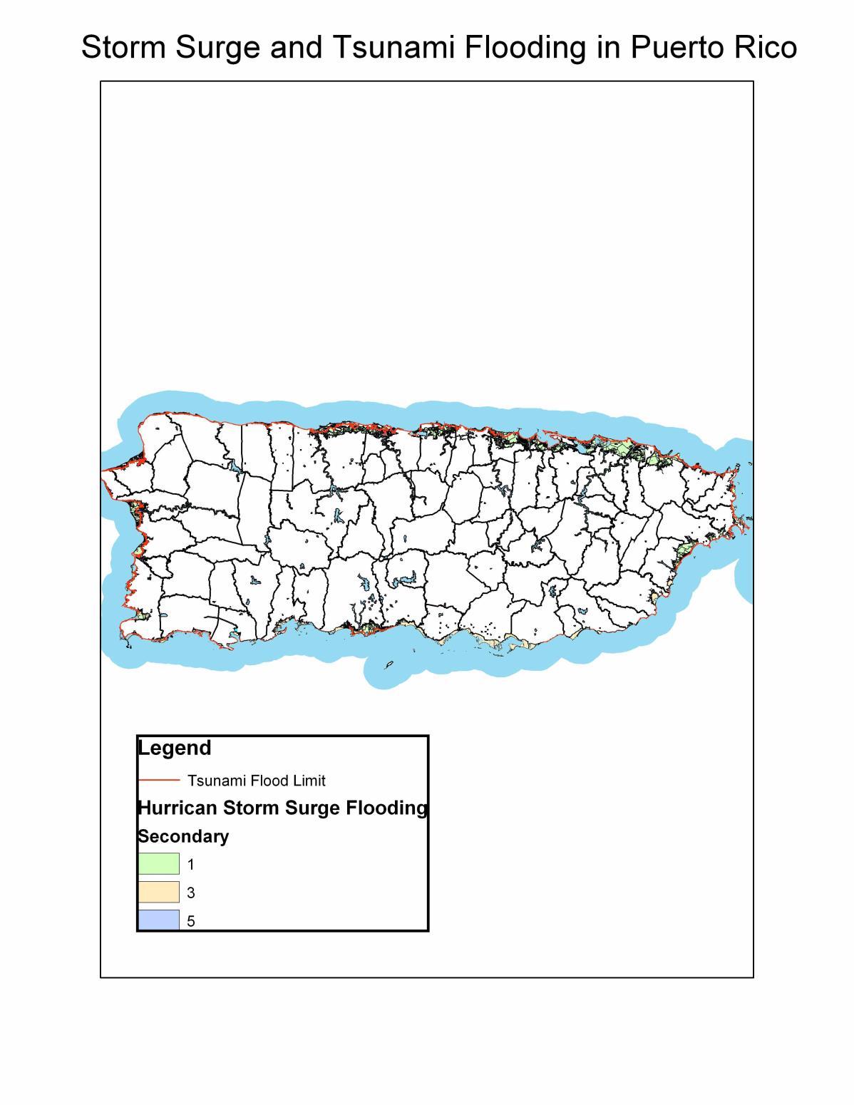
1. Completed digitizing Puerto Rico Storm Surge) into shape file formats for use in GIS applications. (see Figure 1 in the appendix for an example)
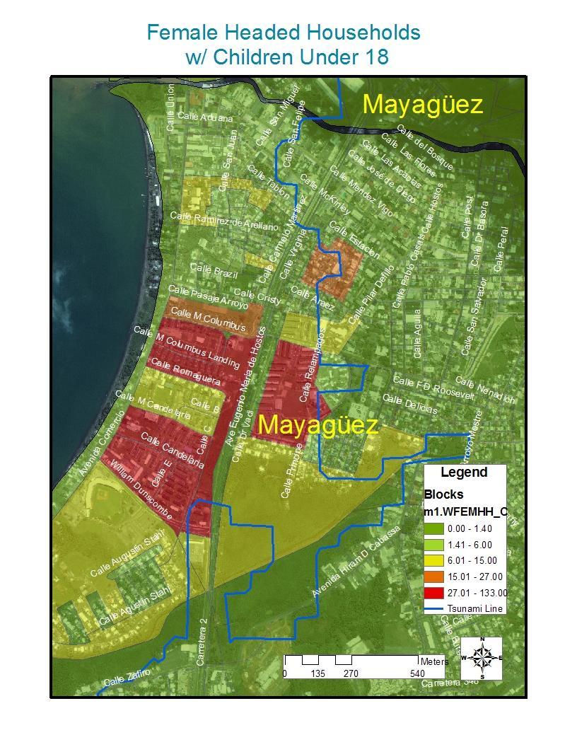
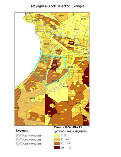
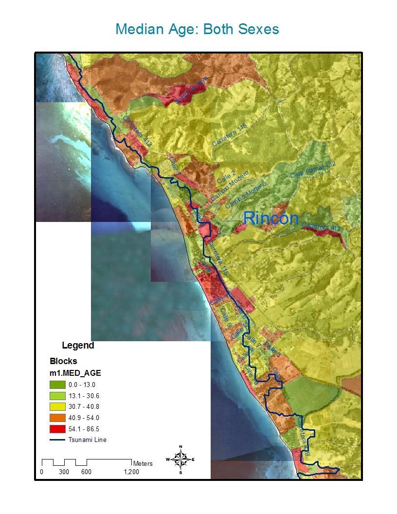
2. Created GIS based maps integrating coastal flooding, 2000 census, topographic, built infrastructures, and satellite data for all of Puerto Rico (Figures 2, 3, 4 and 5 and Table in Appendix 1 for examples
3. Integrated tsunami flooding data into the aforementioned maps. Using these maps, we produced estimates of the amount of people and housing units threatened or exposed to tsunamis and storm surge in Puerto Rico at the census block level of resolution. This significantly reduces problems associated with aggregation effects present in previous work on these issues in the United States wherein Census tracts were used for estimation (See Table 2 in the appendix for an example).
4. Jenniffer Santos has completed the estimation of the first version of the aforementioned vulnerability to storm surge flooding for Puerto Rico. This is an additive index that includes population density and 10 other variables considered to be important determinants of social vulnerability by the literature on disasters (see Table 3 in the appendix).
5. Jenniffer Santos is completing her master’s thesis titled “Development, Vulnerability and Natural Disasters in Puerto Rico” in the Department of Sociology and Criminal Justice at the University of Delaware. For her thesis, Jenniffer generated and used a significant proportion of the data and methods of the Sea Grant project.
Impacts
1. The Disaster Research Center at the University of Delaware has purchased the software necessary to publish on the internet, in an interactive format, the vulnerability maps that we have developed. The maps will be published once the geographic information engine is developed. Again, this will require additional funding to complete.
2. The infrastructure and maps developed as part of this effort have played an important role in the Puerto Rico Tsunami Hazard Mitigation Program, (Christa G. von Hillebrandt, PI) which led NOAA to declare Mayagüez as a Tsunami Ready City in March 2006. The same effort is currently in progress for the town of Añasco.
3. The development of the sampling frame is underway and will be the basis for a survey of evacuation behavior in Puerto Rico to be financed by the United States Army Corps of Engineers during FY 2006-07.
4. Jenniffer Santos, as part of her participation in the Puerto Rico Student Led Test Bed of the NSF Engineering Research Center (ERC) for the Collaborative Adaptive Sensing of the Atmosphere (CASA), is currently leading an interdisciplinary research effort that is building on the data and maps developed as part of the Sea Grant project to construct a vulnerability model that incorporates the social, physical, and built-environment into a GIS-based platform. At this point, the goal is to develop a model that provides a realtime estimate of areas susceptible to floods in Western Puerto Rico.
CASA is a ten-year interdisciplinary research project developing a user-driven network of low-cost, low powered DCAS (Distributed Collaborative Adaptive Sensing) radars with the ability to scan the lower troposphere, where a variety of atmospheric events form. Radars will be placed in locations that allow a greater coverage of the most vulnerable areas to quickly provide end-users with high quality data that could enhance their decision-making process. One 30km polarimetric magnetron radar is already installed in the roof of the Stephanie Building at the University of Puerto RicoMayagüez and the location for four 10km off-the-grid (solar powered) radars is to be determined by April 2007. The research effort is currently working in three proofs of concept test-beds: Oklahoma, Texas, and Puerto Rico.
5. The University of Delaware (UDEL) is engaged in the Coastal Community Development Program, which is a three-college (e.g., College of Agriculture and Natural Resources, College of Marine and Earth Studies, and the College of Human Services, Education, and Public Policy) project focusing on the challenges and difficulties that coastal communities (primarily Sussex County) in the State of Delaware are confronting. Quite similar to the case of Puerto Rico, coastal communities in Delaware have experienced significant population growth, continued residential and commercial development, and the continued expansion of the tourism industry. Consequently, there are increasing concerns regarding the impact of this growth and changes on coastal communities in Delaware. As part of UDEL’s Coastal Community Development program, a number of projects are being developed to focus on recommendations for the enhancement of these communities. As a direct result of our UPR Sea Grant-funded project, researchers from UDEL’s Coastal Community Development Program have asked us to meet with them to discuss how our research can be developed and implemented for coastal communities in Delaware. Havidán Rodríguez already met with one of UDEL’s principal investigators to discuss potential collaborative initiatives based on our research in Puerto Rico. Another meeting is scheduled for January 11, 2007 in which all UD Coastal Community Project principal investigators will meet with Rodríguez, Díaz, and Santos to discuss our Puerto Rico project, findings, and recommendations and to determine how a similar project can be developed for the state of Delaware in conjunction with the Coastal Community Development Program.
6. Finally, it is important to highlight, that the UPR Sea Grant program authorized Dr. Rodríguez to use some of the UDEL-DRC Sea Grant funding to study the aftermath of the 2004 Indian Ocean Tsunami. The DRC team traveled to some of the most affected areas in India and Sri Lanka. The team engaged in a two-week field research expedition that yielded important and perishable data on disaster preparedness, response, and recovery from this devastating tsunami. The team visited and extensive number of fishing and coastal communities in both India and Sri Lanka. Consequently, a significant
number of presentations, reports, and research articles were published (see publication and presentation section below) all which recognized the funding provided by the UPR Sea Grant Program (also see http://www.udel.edu/DRC/tsunami/index.html).
Publications
Rodriguez, H., Wachtendorf, T., Kendra, J. and Trainor, J. (2005). “The Great Sumatra Earthquake and the Indian Ocean Tsunami of December 26, 2004: A Preliminary Assessment of Societal Impacts and Consequences.” Earthquake Engineering Research Institute (EERI) Newsletter, Report No. 4. May 2005, Vol. 39, No. 5:1-7
Rodriguez,H., Wachtendorf,T., Kendra,J., and Trainor, J. (March 2006). “A Snapshot of the 2004 Indian Ocean Tsunami: Societal Impacts and Consequences. Disaster Prevention and Management. Vol. 15, Issue No. 1:163-177.
Trainor, J., Rodriguez, H., Wachtendorf, T., and Kendra, J. (2005). “More than a Wave: Exploring the Social Impacts of the Indian Ocean Tsunami.” Natural Hazards Observer, May 2005, Vol. XXIX, No. 5:1-3.
Wachtendorf, T., Kendra, J.M., Rodriguez, H., and Trainor, J. (June, 2006). “The Social Impact and Consequences of the December 2004 Indian Ocean Tsunami: Observations from India and Sri Lanka.” Earthquake Spectra, Vol. 22, No. S3:S693-S714.
Planned publications (2007-2008)
1. Díaz, Rodríguez and Santos, refereed journal article analyzing vulnerability to storm surge and tsunami flooding in Mayagüez, Puerto Rico.
2. Santos, Masters thesis to be completed during the Spring semester of the 2006-07 academic year at the University of Delaware.
Presentations
Díaz, Walter “Population Composition, Geographic Distribution, and Natural Hazards: Vulnerability in the Coastal Regions of Puerto Rico.” Presented at the Congreso Anual de la Agencia Estatal para el Manejo de Emergencias y Desastres de Puerto Rico San Juan, PR. May 5th, 2005. With Havidán Rodríguez (PI), Jenniffer Santos and Aurelio Mercado.
Díaz, Walter. “Population Composition, Geographic Distribution, and Natural Hazards: Vulnerability in the Coastal Regions of Puerto Rico II.” Presented at the 2nd Annual Symposium for Coastal and Marine Applied Research, University of Puerto Rico Sea Grant College Program. Mayagüez, Puerto Rico. October 5, 2006. With Havidán Rodríguez (PI), Jenniffer Santos and Aurelio Mercado.
Díaz, Walter “Population Composition, Geographic Distribution, and Natural Hazards: Vulnerability in the Coastal Regions of Puerto Rico.” Presented at the 1st Annual
Symposium for Coastal and Marine Applied Research, University of Puerto Rico Sea Grant College Program. Mayagüez, Puerto Rico. September 2, 2005. With Havidán Rodríguez (PI), Jenniffer Santos and Aurelio Mercado.
Rodriguez, H. “A Snapshot of the 2004 Indian Ocean Tsunami: Societal Impacts and Consequences.” Presented at the 1rst Annual Symposium for Coastal and Marine Applied Research, University of Puerto Rico Sea Grant College Program, Mayagüez, Puerto Rico, September 2, 2005 (with Tricia Wachtendorf, James Kendra, and Joseph Trainor).
Rodriguez, H. “Building Sustainable Recovery and Development Initiatives: A Critical Overview of India and the Indian Ocean Tsunami.” Paper presented at the Natural Hazards Workshop in the Plenary Session, “Asian Tsunami: Impacts and Sustainable Recovery.” Boulder, Colorado, July 11-13, 2004.
Rodriguez, H. “From the Indian Ocean Tsunami to Katrina: The Social Construction of Disasters and Catastrophes.” Presented at the Annual Faculty Lecture, University of Delaware Morris Library, Newark, Delaware, June 1, 2006.
Rodriguez, H. “Societal Impacts of the Indian Ocean Tsunami: Preliminary Findings from India and Sri Lanka.” Presented at the EERI Technical Briefing: The Great Sumatra Earthquake and Tsunami of December 26, 2004, Marvin Center, George Washington University, May 23, 2005 (with Tricia Wachtendorf, James Kendra, and Joseph Trainor).
Rodriguez, H. “Socio-economic Impact and Consequences of the Indian Ocean Tsunami: Preliminary Findings from India and Sri Lanka.” Presented at the 2005 NDMS Disaster Response Conference Orlando, Florida, May 4, 2005 (Funded by FEMA) (with Tricia Wachtendorf, James Kendra, and Joseph Trainor).
Rodriguez, H. “The 2004 Indian Ocean Tsunami: The Social Science Implications of Response and Recovery Initiatives.” Presented at the International Conference on Energy, Environment, and Disasters (INCEED 2005). Charlotte, North Carolina, July 24-30, 2005 (with Tricia Wachtendorf, James Kendra, and Joseph Trainor).
Rodriguez, H. “The Indian Ocean Tsunami: A preliminary Assessment of Societal Impacts and Consequences.” Paper presented at the FEMA Emergency Management Higher Education Conference, Emmitsburg, Maryland, June 7-9, 2005 (with Tricia Wachtendorf, James Kendra, and Joseph Trainor).
Rodríguez, H.; Díaz, W.; Santos, J.; Mercado, A. “Population Composition, Geographic Distribution, and Natural Hazards: Vulnerability in the Coastal Regions of Puerto Rico”. First Annual Symposium on Coastal and Marine Applied Research. University of Puerto Rico-Mayagüez. September 2, 2005.
Santos, J. “Development, Capital and Disasters: Social Vulnerability in Puerto Rico’s West Coast” Third Puerto Rican Conference on Public Health. Graduate School of Public Health. University of Puerto Rico-Medical Sciences Campus. San Juan Convention Center. Forthcoming May 8-10, 2007. Abstract Submitted.
Santos, J. “Geographic Information Systems and Social Scientific Research: Understanding Vulnerability to Disasters in Puerto Rico’s West Coast” Disaster Saloon Series. Disaster Research Center. University of Delaware. Forthcoming March, 2007.
Santos, J., Rodríguez, H. Díaz, W. “Agency, Inequality and Power: Vulnerability to Disasters in the West Coast of Puerto Rico” 31st Annual Hazards Research and Applications Workshop. University of Colorado-Boulder. July-9-12.
Santos, J., Rodriguez, H. Diaz, W. Mercado, A. “Population Composition, Geographic Distribution, and Natural Hazards: Vulnerability in the Coastal Regions of Puerto Rico”. First Annual Symposium on Coastal and Marine Applied Research. University of Puerto Rico-Mayagüez. Poster Presentation. September 2, 2005.
Wachtendorf, T. Rodriguez, H., Kendra, J., Trainor, J. “Societal Impacts of the Indian Ocean Tsunami: Preliminary Findings from India and Sri Lanka.” Presented at the Disasters Roundtable on the Indian Ocean Tsunami Disaster: Implications for U.S. and Global Disaster Reduction and Preparedness. National Research Council, The National Academies, Washington, DC: June 21, 2005.
Conclusion
The major objectives established by the project’s proposal have been accomplished in spite of important obstacles regarding the availability of the necessary flooding data. Furthermore, our research, as shown in this document, is already impacting other research and outreach efforts and initiatives such as the aforementioned projects by the Puerto Rico Seismic Network, NOAA, NSF and the United States Army Corps of Engineers.
Appendix – Tables and Figures

2: Female Headed Housing Units with Children Under 18 in Exposed Census Blocks in Mayagüez


4: Ponce-Population Over 65 Years of Age Exposed to Coastal Flooding

5: Topography and Median Age in Exposed Census Blocks

Table 1: Puerto Rico-Some Indicators of Social Vulnerability to Storm Surge Flooding**
* Population data obtained from the U.S. Census 2000
Table 2: Social/demographic vulnerability to Tsunamis within the Mayagüez Tsunami Hazard Area* **
*Weighted estimates ** Population data obtained from the U.S. Census 2000
%
