Final Report
-Title: Coastal Ecosystem Assessment, Development, and Creation of a Policy Tool using Unmanned Aerial Vehicles (UAVs) for A Case Study of Western Puerto Rico Coastal Region
-Name and affiliation of researchers:
Jonathan Muñoz Ph.D.
Associate Professor, Department of Civil Engineering, University of Puerto Rico-Mayaguez
-Background
Coastal monitoring is fundamental to understand the morphological changes in coastal environments and the vulnerability of low-lying coasts to erosion and flooding. For this reason, this study was focused on monitoring coastal erosion in different areas distributed along the western region of Puerto Rico using small unmanned aerial vehicles (UAVs). These UAVs provided rapid-assessment and high-resolution images for shoreline monitoring from 2016 to 2018. The images served to establish a baseline aerial analysis useful to quantify the erosion rate using the Digital Shoreline Analysis System (DSAS) and computing the rate-of-change statistics of the coastal zones from multiple historic (1930 to 2010) shoreline positions. In addition, XBeach was implemented to simulate swell events generated by Hurricane Matthew (Category 4) in 2016. The results demonstrated the synergy of low-cost small UAV surveys and XBeach modeling to monitor the coastal zones and determine morphological changes in coastal environments.
Other tasks from this work included outreach and educational training on UAVs for environmental monitoring. One special topic course - INCI 4998 Geospatial Mapping Using UAVs, was offered at the Department of Civil Engineering (spring 2017), two students were sponsored to obtain their FAA – Small UAV Pilot and one graduate student completed her thesis using data gathered by this research initiative.
-Results and findings:
UAV Monitoring:
All observational sites that encompass the denoted Caribbean Littoral Aerial Surveillance System (CLASS) were established and the historical shoreline position and erosion rate from 1930 to 2018 determined (Appendix A – Progress Report March 2018)
During the performing period of this project; 2 major storms directly impacted Puerto Rico On September 6, 2017, hurricane Irma passed north of Puerto Rico causing adverse maritime conditions and on September 20, 2017, hurricane Maria (Category 4 - Saffir-Simpson Hurricane Wind Scale) directly impacted Puerto Rico, causing major storm surges and floods across the coastal region. An extensive data collection program was executed. Aerial imagery was collected for Hurricane’s Irma and Maria As well, a new set of aerial images was acquired 180 and 365 days after the Hurricane Maria. All images were post-processed to observe the shortterm recovery of the coastal zone and are available to the scientific community
Case Study:
Modeling Analysis Effects of Hurricane Matthew at Cofresí Beach, Rincón, PR:
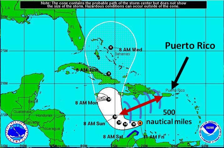
In October 2016, UAVs were deployed to perform a rapid assessment and evaluate the effects (pre and post) of the Hurricane Matthew (Category 4) at Rincón, PR. This hurricane was 500 nautical miles away and the southwestern direction of the generated swell severely impacted the western region of Puerto Rico (Figure 1).
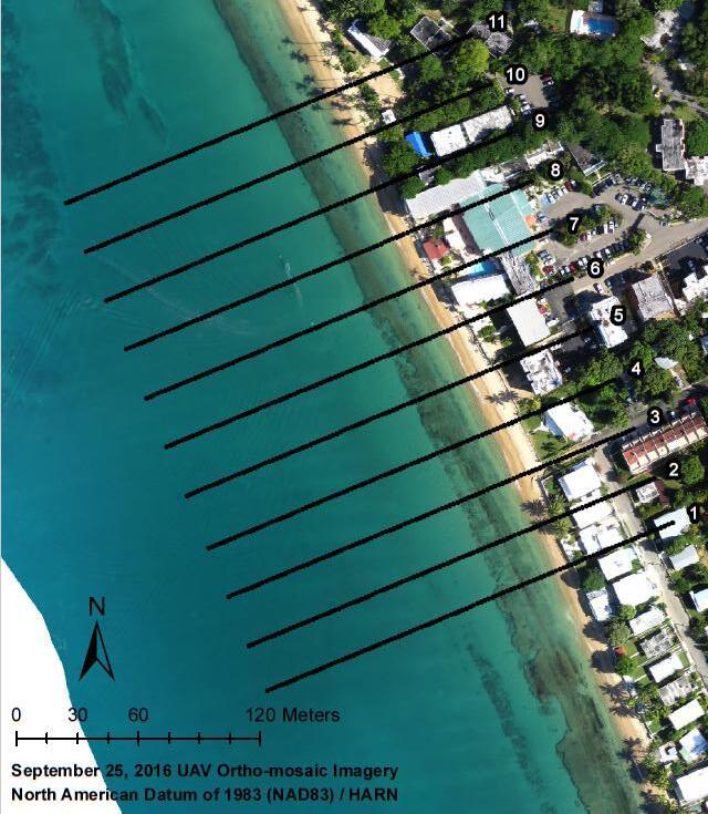
For this event XBeach was used to evaluate the morphological changes at the foreshore induced by this storm event at Rincón. The results were validated using UAV derived digital surface models (DSMs). XBeach showed potential to determine the morphological changes in the coastal zone and quantify the erosion or accretion events caused by the hurricane.
Figures 3-4 and tables 1-3 provide the modeled simulation, the comparison between numerical simulation and field observations, and a correlation analysis of beach profiles. As well, beach profiles were generated to represent the initial bed level and simulated bed level results obtained from the numerical simulations, each profile has a subplot that contains the beach portion of each transect to easily compare the variation (see: https://scholar.uprm.edu/handle/20.500.11801/1952).
Table 1. Average erosion results of the XBeach simulation in the vertical direction
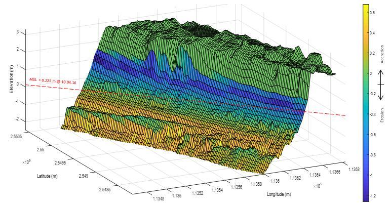
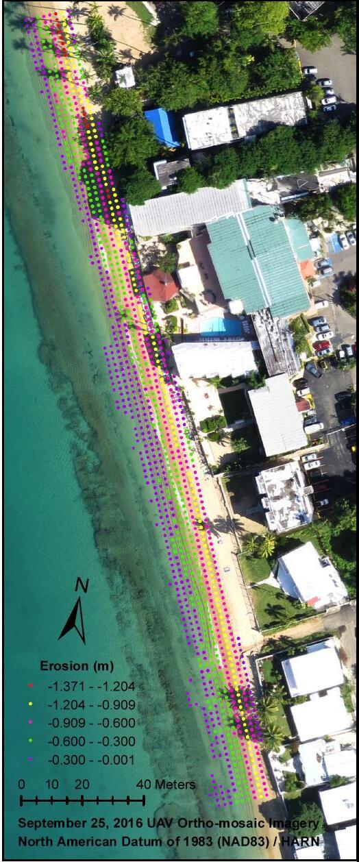
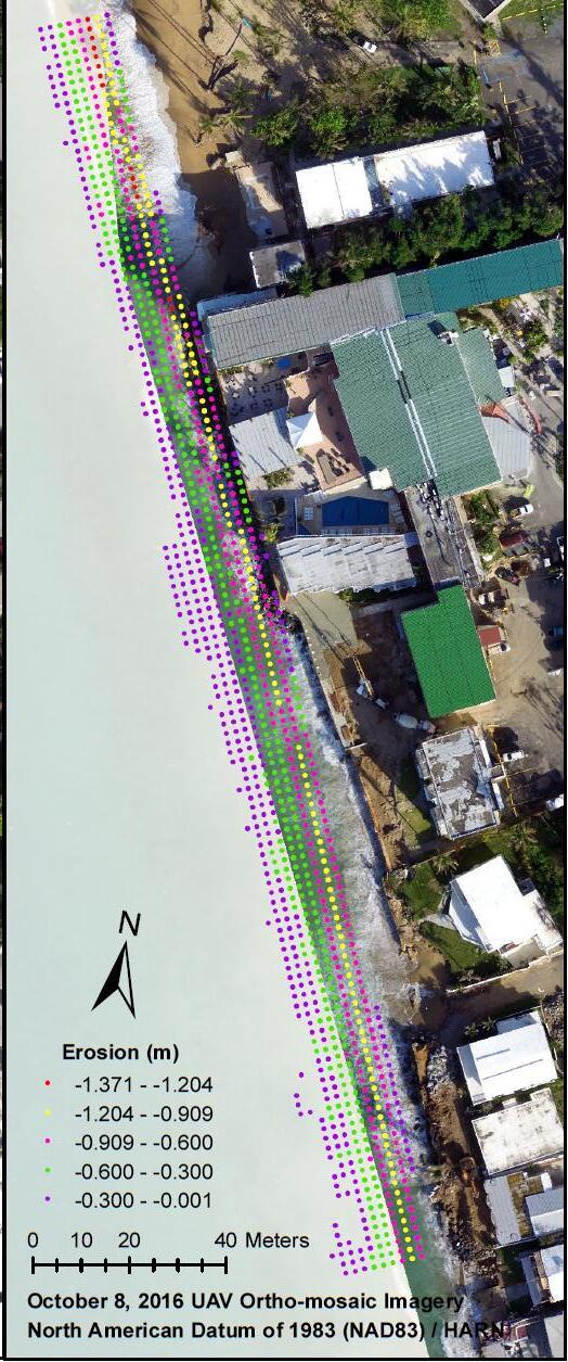
Figure 1. Erosion values from the simulation results along the coastline using UAV ortho-mosaic images (a) before and (b) after Hurricane Matthew. Image (a) shows the modeled erosion over the pre event aerial image (25 September 2016).
For the validation of the model output (vertical direction-elevation), the average and the standard deviation was calculated from the UAV and XBeach average erosion. A statistical analysis including the MBE, MAE, RMSE, and R was performed considering both data sets (Table 2).
Table 2. Statistical analysis for the erosion results in the vertical direction
Based on the average results, XBeach underestimated the erosion in the vertical direction. The average erosion obtained between UAVs and XBeach was -0.747 meters. For the standard deviation, UAV values seemed to be more spread out compared to the XBeach values. When determining the MAE among all the analyzed profiles, a discrepancy of 0.464 meters was observed between both samples. This discrepancy was equivalent to a 62% of the total erosion. However, when determining the MBE, an error of -10 centimeter was obtained; indicating that positive and negative errors cancelled out. The XBeach model and UAV results showed great variability, however, the overall results were consistent between both. The negative error indicated that XBeach prediction results were smaller in value than UAV observations. The RMSE value was 0.556 meters, indicating a moderate error associated with the simulation results; and the coefficient of correlation was 0.513, indication a moderate lineal relationship.
Table 3. UAV and XBeach pre- and post-storm profile correlation results
For the correlation results before Hurricane Matthew, almost all transects showed high R2 values. The results may have been influenced since the DSM had the bathymetry data combined with the topography. The post-storm results, compared with the pre-storm results, were lower almost in all transects. Similarly, this could have been caused since the used DSM did not have bathymetry information. The DTM R2 results were quite similar with the DSM, except for a few transects. Overall, the average R2 values from pre- and post-storm were acceptable, and the difference between the used of DSM and DTM for the detection of morphological changes was almost negligible. The R2 post-storm results could improve by implementing a hybrid model that includes bathymetry data and optimizing the DSM and DTM with more ground control points.
Project Conclusions:
In this study the erosion rates were determined for the periods 1930-2004, 2004-10, 2010-16, 2016-17, 2017-18, and 1930-2018. Specifically, the erosion events after Hurricane María were determined and the results were -1.42 m/yr, -38.11 m/yr, and -3.82 m/yr for Jobos Beach at Isabela, Crash Boat Beach at Aguadilla, and Cofresí Beach at Rincón respectively, other coastal areas were analyzed. These results demonstrate the vulnerability of these beaches, and that government attention is required.
XBeach numerical model simulations showed potential to determine morphological changes in the coastal zones. Additionally, the numerical model results demonstrate capabilities to simulate erosion and/or accretion events using real-time meteorological and oceanographic data. Both vertical and longitudinal results were consistent with UAV data. However, the results showed in this study were obtained using a model simplification by implementing uniform wave conditions; hence, a sensitivity analysis needs to be performed.
The UAV data was used to validate the XBeach simulation and the results shows potential to use UAV data in combination with bathymetry data as model input. The results from the validation showed that both methodologies coincide when determining erosion and/or accretion events. In order to optimize the results, it is recommended to calibrate the way in which the shoreline is delimited using UAV images, optimize the modeling by considering variable wave conditions, and increasing the grid resolution. The implementation of a model that predicts the swell is recommended in combination with XBeach to capture accurately the morphological changes along the coasts. It is also recommended the systematic collection of UAV images that match with the tide pre-conditions.
To conclude, the methodology implemented as part of this Sea Grant project could be readily implemented in other areas of Puerto Rico where a rapid assessment is needed after any meteorological event. The results obtained from this analysis may be used as a tool to educate the population living near the coastal zone about the actual problems the coastal communities are suffering. It is recommended to outreach public awareness of coastal risk communities and to include transitioning monitoring for local emergency managers.
Direct products of this research include:
1) Historic Accretion and Erosion Rates at selected coastal zones of western Puerto Rico.
2) Modeling approach combining XBeach, UAVs Imagery and CARICOOS Data to predict coastal erosion.
3) Training for students in UAVs technologies.
-List PI’s supported
Jonathan Muñoz (PI) oversees the design and supervision of all tasks. 22% of his time is dedicated to this effort (3 credits/semester released load)
-List students supported:
Graduate Students
1) Name: Glorimar Torres: (MSc. Civil Engineering)
Degree: MSc. Civil Engineering (Geotechnical)
Email: glorimar.torres@upr.edu
Time/Effort: 2 years ( 20 months )($24,000 total amount)
Task: Collection, calibration, and analysis of data @ CLASS Sites
Glorimar’s was the lead student for this endeavor. She oversaw and conducts the tasks stated in the proposal regarding the collection and interpretation data. She wrote her Master Thesis on the subject and graduated on date June 2018. She currently works as Geospatial Analyst at the US Army Corps of Engineering, Jacksonville District.
2) Francisco Villafañe
Degree: MSc. Civil Engineering (Structural)
Email: francisco.villafane@upr.edu
Task: UAV Pilot – Data Collection
Francisco Villafane: was partially supported by this project and completed his Master of Science in Civil engineering during fall 2017.
Undergraduate
3) Priscilla Vargas-Babilonia (Civil Engineering)
Degree: B.Sc. Civil Engineering
Task: Data Analysis
Graduated June 2018
4) Alexander Perez-Ortiz
Degree: B.Sc. Land Surveying
Email: alexander.perez8@upr.edu
Task: UAV Pilot – Data Collection
5) Jorge Soldevila
Degree: B.Sc. Land Surveying Task: GIS – Data Collection
6) Michael Quinones
Degree: B.Sc. Land Surveying Task: GIS – Data Collection
Table 4 Supported Students 2017-2019
Other
-Publications:
1) J. Muñoz, and G. Torres. “Rapid Storm Damage Assessment using Unmanned Aerial Vehicles”, to be submitted to Natural Hazards and Earth System Sciences (In preparation)
2) L. Aponte, J.Muñoz, F. Villafañe and G. Torres. “Huracán María: Sinopsis y Análisis Preliminar del Impacto en la Infraestructura de Puerto Rico”, published at Dimension (ISSN 2167-7832)
3) L. Aponte, J.Muñoz, F. Villafañe and G. Torres. “Impacto de la erosión costera a la infraestructura de Rincón, Puerto Rico”, published at Dimension (ISSN 2167-7832)
-Presentations:
1) J. Muñoz, L. Aponte, and G. Torres (2017), Coastal Erosion assessment using Unmanned Aerial Vehicles(UAVs) for: A Case Study of Western Puerto Rico Coastal Region. AGU Fall Meeting, December 13, 2017, New Orleans, Louisiana. (Oral)
2) G.Torres and J. Munoz (2018), Coastal Erosion assessment using Unmanned Aerial Vehicles(UAVs). NOAA’s 9th Biennial EPP Forum, Mar 18-2, 2018, Washington DC
3) J. Munoz, L Aponte and P. Chardon (2018), Post-Disaster Assessment Monitoring Hurricane Maria in Rincón CIAPR – Civil Engineering Institute “Mega Martes Civil”, May 6, 2018, Mayaguez, PR.
-Recap:
UAV’s were being used to assess and create a baseline of coastal erosion in the Puerto Rico Western region. UAV’s where deployed before and after hurricanes Irma and Maria. As well short-term recovery of the coastal zone is being analyzed.
-Relevance:
Several reports about Puerto Rico shorelines indicate increased erosion losses in certain parts of the shore. To mitigate these problems is important to monitor the erosion over time, with a special interest in pre/post-storm events.
-Response:
One of the many contributions of this work is the establishment of the 5 observational sites that encompassed the denoted Caribbean Littoral Aerial Surveillance System (CLASS). The idea behind CLASS is to produce a robust data set of coastal erosion and vegetation evolution, allowing local stakeholders to develop policy tools. Low-cost imagery was collected before and after hurricanes Irma and Maria.
-Results:
Effective shoreline monitoring systems are needed to provide the foundation to determine erosion or accretion rates along the island and its impact on coastal infrastructure. Such actions will lead to the development of effective action plans to be implemented by the Government of Puerto Rico and its Coastal Municipalities.
