Exec utive Su mmary
Pro ject title: A Pilot Study to Investigate the Possible Linkages Bet ween Subm arine Groundwater Fluxes and Amphitheate r-Sh aped Sca rps on the Northern Insular Margin o f Puerto Rico
Dat e: May 20, 2008
Pro ject Nu mbe r: #R-122-1-04
Investigators an d a ffiliation:
Principal Investigator: Nancy R Grindlay, C enter for Marine S cience , University of North Carolina
Wilmington
Co-Principal Investigator: Willard S Moore , Departm ent of Geological Scien ces, University of South Carolina
Dat es Cover ed : Mar ch 1, 2004 - F ebruary 28, 2008
Su mma ry of I mpac ts an d Co ntri butions inclu ding:
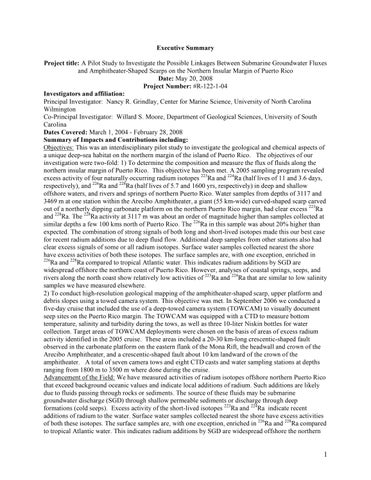
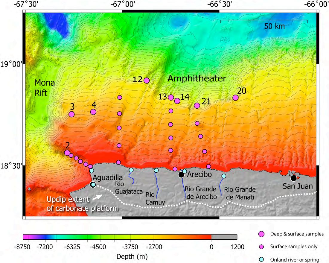
Objectives: This was an interdisciplinary pilot study to investigate the geological and che mical aspects of a unique de ep-sea habitat on the northern ma rgin of the island of Puerto Rico Th e objectives o f our investigation were t wo-fold: 1) To deter mine the co mp osition and measur e the flux of fluids along the northern insular margin of Pu erto Ri co This objective has been met A 2005 sa mpling progra m r evealed excess a ctivity of four n aturally occu rring radiu m isotopes 223Ra and 224Ra (half lives o f 11 and 3 6 days, respectively), and 226Ra and 228Ra (h alf lives of 5 7 and 1600 yrs, r espectively) in de ep and shallow offshore waters, and rivers and springs of northe rn Pu er to Rico. Water sa mples f rom depths of 3117 and 3469 m at one station within the Ar ecibo Amphitheater , a giant (55 k m- wide) curv ed-shaped scarp ca rved out of a no rtherly dipping carbonate platfor m on the no rthern Pu erto Rico margin, had clear exc ess 223Ra and 228Ra. The 228Ra a ctivity at 3117 m was about an or der of m agnitude higher than s amples collected at similar depths a fe w 100 k ms north of Pue rto Rico . The 226Ra in this sample was about 20 % higher than expected. The combination of strong signals of both lo ng and short-lived isotopes m ade this our b est cas e for r ecent radium additions due to deep fluid flo w Add itional deep samples fro m other stations also had clear excess signals of som e or all r adium isotopes. Sur face wate r sa mples collect ed ne arest the shore have ex cess a ctivities of both these isotopes. The surf ac e sa mples ar e, with one exception, enriched in 226Ra and 228Ra co mpar ed to tropical Atlantic water . Th is indicates radium additions by S GD are widespre ad of fshore the northern coast of Pue rto Rico . Ho wev er, analyses of coastal springs, se eps, and rivers along the north coast sho w relatively lo w activities of 223Ra and 224Ra that are similar to low salinity samples we have measur ed else wh ere .
2) To conduct high-resolution geological mapping of the a mphitheater-shap ed sca rp, upper platfo rm and debris slopes using a to wed ca mer a system . This obje ctive was met. In Septe mber 2006 we conducted a five-day c ruise that included the use o f a deep -towed c a mer a system ( TOWC AM) to visually document seep sites on the Pue rto Rico m argin. Th e TOWC AM was equipped with a C TD to measur e bottom temper ature, salinity and turbidity during the tows , as well as thre e 10-liter Niskin bottles for water collection. Target ar eas of TOWC AM deploym ents we re chosen on the b asis of are as of excess radium activity identified in the 2005 cruise . Th ese are as included a 20 -30 km -long cres centic-shaped fault observed in the carbonat e platfor m on the e astern fl ank of the Mona Rift, the he ad wall and cro wn of the Ar ecibo Amphitheater, and a cresc entic-shaped fault ab out 10 km land ward of the cro wn o f the amphitheater A total of sev en c am era tows and eight C TD c asts and water s ampling stations at depths ranging fro m 1800 m to 3500 m where done du ring the cruise. Advan cem ent of the Field: We h ave me asured activities of r adium isotopes offshor e northern Pu erto Ri co that exceed background oce anic values and indicate loc al additions of radium Such additions are likely due to fluids passing through rocks or sedim ents The s ource of these fluids may be sub marine groundwate r discharg e ( S GD) through shallow per me a ble sediments or discharge through deep formations ( cold seeps) Excess activity of the short-li ved isotopes 223Ra and 224Ra indicate r ecent additions of radium to the wate r. Sur fac e wat er sa mples collected n earest the shore have exc ess activities of both these isotopes Th e surf ace sa mples ar e, with o ne exc eption, enrich ed in 226Ra and 228Ra co mpar ed to tropical Atlantic water This indicates radium additions by S GD ar e widespre ad of fshore the northern
coast of Puerto Rico. A d eep-to wed ca me ra syste m was used to visually docum ent seep sites on the margin. Digital still images docu mented white halos, pr esumably c arbonate deposits associated with seeps, around a string of E- W trending fissures at the cr own o f an a mphitheater-shap ed sca rp whe re clear radium excess was measur ed The TOWC AM system measur ed ne ar-bottom turbidity and te mpe rature anomalies associated with these fe atures.
Pro ble ms enco un ter ed: Cr u i s e Del a y : The initial m ar ine field progra m was originally scheduled to be conducted aboa rd the R/ V Ch a p ma n , o wned and oper ated by the Unive rsity of Pu erto Mayagü ez, in late January 2005 Ho wev er, in mid- Dec emb er of 2004, Gr indlay was inform ed that the R/ V Ch a p ma n did not have the n ecessa ry length of C TD cable for deep - water sa mpling and would not b e av ailable for either field progra m. Grindlay was able to resch edule the crui se aboard the UNOLS v essel R/ V Pel i ca n op erated by Louisiana Unive rsity Ma rine Consortium. The first cruise was postponed until Mar ch 28- April 2 , 2005 The se cond field p rogra m was delayed until Sept ember 2006 (b eyond the original gr ant timef ra me)
Res earc h I mpacts: This preliminary study is a first ste p towa rds ev aluating the ground water contribution to the coastal waters of f northe rn Pu erto Rico This is a n important and practic al issue that ne eds to be addressed in ord er to qu antify the a mount of potential pollutants (e.g excess nutrients) that contaminate the coastal waters I f these onland springs and rivers ar e the sourc es of exc ess radiu m of fshore northe rn Puerto Rico, very l arge volu mes of S GD a re required to balance the coastal signal Th erefo re eff ective manage ment of runo ff and ground water qu ality onshore is impe rative given the potentially significant impact on the coast o cean environm ent
Oth er importa nt impacts or pro du cts:
Peer - Revie wed Publications:
Grindlay, N R., M He arne , and P Mann , A High Risk of Tsunami in the Northe rn C aribbean , Eo s Tr a n s a ct i o n s . A m er i ca n Geo p h ys i ca l Un i o n , 86(12) , 12 1, 2005.
He arne , M., N. R. Grindlay, and P. M ann, Re current submarine landsliding offshore northern Pue rto Rico, M a r i n e Geo l o g y , in r evision.
Hornba ch, M , Mond ziel, S., Grindlay, N R., P. Mann, and Frolich, C , Did a subma rine slide trigger the great 1918 Puerto Rico tsuna mi? S ci en ce o f Ts u n a mi H a z a r d s , in revie w.
Grindlay, N.R. and Moor e, W.S. ,Evidenc e fo r de ep ad vective fluid flo w on the northern Pue rto Rico margin, in prep . Geo ch e mi s t r y, Geo p h ys i cs , G eo s ys t e ms , Anticipated submission July 2008
Grindlay, N.R., Mondziel, S ., M ann, P., Es colona, A an d Ab ra ms, L., C retac eous-re cent extension of the northern Pue rto Rico Margin: Te ctonic evolution of the Mona C anyon, in p rep. Ma r i n e G eo l o g y, Anticipated sub mission August 2008.
Abstra cts and Presentations (*denotes presente r):
Grindlay, N.R.* and Moor e, W.S., A Pilot Study to Inv estigate the Possible Linkages Bet ween Subm arine Ground wat er fluxes and Amphitheater -Shap ed S carps on the Northern Insular Ma rgin of Puerto Rico, Un i ver s i t y o f Pu er t o Ri co S ea Gr a n t 1 st An n u a l S y mp o s i u m o n Co a s t a l a n d Ap p l i ed Ma r i n e Res ea r ch , a b s t r a ct vo l u me, 3 , 2005
Grindlay, N.R. and Moor e, W.S.* , Evidenc e of significant deep and shallo w adv ective fluid flo w offshore northern Pue rto Rico , Eo s Tr a n s a ct i o n s . A mer i ca n G eo p h ys i ca l Un i o n , 87(36), Oc ea n S ci . Me et . S u p p l , Abstract OS14 A-06, 2006
Mondziel, S.* , Grindlay, N R , M ann, P. and Ho rnbach , M., Tsuna mi potential offshore NW Pue rto Rico I: M apping sctive gaults and mass wasting featur es in t he Mon a Rift, G eo l o g i ca l S o ci et y o f A m er i ca
An n u a l Me et i n g Ab s t r a ct s wi t h Pr o g r a ms , 39 (6) 57-21 , 2007.
Hornba ch, M * , Frolich, C , Mann, P , Mondziel , S. an d Grindlay, N R Tsuna mi potential offshor e NW Puerto Rico I I: R e-ev aluating the source of the 1918 Pu erto Rico Tsunami , Geo l o g i ca l S o ci et y o f
A mer i ca An n u a l Meet i n g , Ab s t r a ct s wi t h Pr o g r a ms , 39 (6) 57-22, 2007
Grindlay, N R*, Moore, W S. and P E06-45 Shipboard Scientific Party, A d eep-to wed ca mer a investigation of deep fluid flo w sites of fshore no rthern Puerto Rico, Eo s Tr a n s a ct i o n s A mer i ca n
Geo p h ys i ca l Un i o n , Oc ea n S ci Me et S u p p l , Abstra ct 89-1400, 2008
Grindlay, N.R.* , Mondziel, S ., P . Mann and A. Esc alona, Mid- Oligocene- Re cent extension on the northern Pue rto Rico m argin, 1 8 th Ca r i b b ea n Geo l o g i c a l Co n f er en ce , Do mi n i ca n R ep u b l i c, M eet i n g a b s t r a ct s a n d p r o g r a m, Abstra ct 54, p 28 , 2008
Grindlay, N R.* , S. Mondzi el, P. M ann and A Escalon a, Mid- Oligocene- Re cent rifting in the norther m Mona Passage , Tectonophysics in the Northe astern Car ibbean Plate and Associated S eismic and Tsuna mi Ha zards: A revie w fro m current knowl edge to Future Res ear ch Confer ence , Madrid, Sp ain, June 2007
Grindlay, N R.* , M. Hornba ch, S. Mondziel, and P. M a nn, R e-evaluating the cause of the 1918 Tsuna mi, Te ctonophysics in the Northeastern C aribbean Plate an d Associat ed S eismic and Tsuna mi Ha zards: A Revie w fro m Current Kno wl edge to Future Rese arch C onferenc e, M adrid, Spain, June 2007
Grindlay, N R., Risk of Tsuna mi in the Northern C arib bean: Pue rto Rico Tren ch, Se mi-annual Boa rd of Trustees M eeting, Unive rsity of North Carolina Wilmi ngton, October 2007
Grindlay, N R., Th e Risk of Tsuna mi: Ho w, Wher e and When? , Planet Ocean Se minar series , Center for Marine S cience , University of North Carolina Wil mington, M ay 2008
Stu de nt involve men t in res earc h c ruises:
Jennie M ancinone – University of North Ca rolina Wilmington graduate
Kelly Robertson – Unive rsity of North Ca rolina Wilmi ngton undergraduate
Brant And erson – Unive rsity of South Carolina Colum bia undergraduat e Ve ronica Di az – University of Puerto Rico May agüez u ndergraduate
Steve Mondziel - University of North Carolina Wil mington, graduate
Kassy Rodriguez - University of North Ca rolina Wilmi ngton, graduate
Stu de nt Researc h Su ppo rte d ( Th eses a bstrac ts in Appe ndix III):
Meghan Hea rne – University of No rth C arolina Wilmin gton Geology MS , In ves
l a n d s l i d es a l o n g t h e n o r t h er n Pu er t o Ri co - Vi r g i n Is l a n d s ma r g i n , p.87, 2004., graduated August, 2004, now at Mindo and Moore, S an Diego, C A, m eggiehearne @yahoo.co m
Steve Mondziel – University of No rth C arolina Wilmin gton Geology MS , Mo r p h o l o g y,
d t ect o n i c evo l u t i o n o f Mo n a Ca n yo n , Pu er t o Ri co , p . 93 , 2007, gr aduated Dec. 2007, no w at Hess Corporation, Houston, TX, smondziel @yahoo .co m
Sour ces of mat ching fu nds: University of No rth C arol ina Wilmington, C enter for Ma rine Scienc e, $10,000.
Ne w ext ra mu ral f un ds in additio n to matc h: None
Ben efits: Compilation of existing multibeam b athymetr y and marine geophysical data for the proje ct led to the identification of seve ral mass- wasting features in the c arbonate platfo rm at the head of the Mon a Canyon offshor e NW Pu erto Rico. One such featur e ha s been used to succ essfully model the tsunami runup heights for the great 1918 Pue rto Rico tsunami which, until rec ently, was assumed to be caused by seafloor rupture associated with 1918 M7 .3 e arthquake . Although not typically thought to be tsunamigenic, given the steep and na rro w insular shelf, and the block failure o f the carbon ate platfor m that surrounds the island, this study showed that sub ma rine landslides can pose a serious thre at to the coastal co mmunities of Pue rto Rico .
Pro ject Nar rative
State men t of th e Pro ble m
The C aribbean ecor egion is considered one of the most challenging regions in the world in ter ms of understanding its undersea habitats The g eology is widely divers e with shallow shelf are as f alling off to deep wat er only a short distance fro m many island shorelines A striking exa mple of this extre me change in se afloor relief is found 150 k m north o f the is land of Pu erto Rico whe re the sea floor plunges to 8400m in the Puerto Rico Tr ench, one o f the deepest r egions of all the wo rlds oce ans, and the d eepest point in the Atlantic Ocean The Puerto Rico Trench , a n east- west tr ending submarine valley, delineates the boundary bet we en the Ca ribbean and North Ame ric a plates The tr ench extends over 700 km bet we en the Lesser Antilles Island arc ch ain to the e ast and the Hispaniola de form ed belt to the west
A combination of sever al physical, che mical and geolo gic elem ents m ake the northern insular margin of Pu erto Rico a unique de ep-sea habitat The northern shelf and slope of Pue rto Rico consist of a steep, north ward dipping (4-5o), mixed clastic-ca rbonat e platfor m r anging in depth fro m 0 -6700 m and from 70-90 km in width ( Moussa et al. 1987; van Gestel et al. 1999). The uppe r slope is cut by a numbe r of nea rly straight, do wnslope trending canyons fro m 1 to 3 km wide and up to 400 m deep . These c anyons have be en interpreted as o ffshore transport conduits for shelf sedim ents probably in the for m of turbidity currents Two giant amphitheate r-shaped subma rine sc arps occu r half way bet ween the shelf br eak and base of slope at a depth o f about 3000 m. Th e larg est s carp is about 55 km a cross and repr esents the removal of an estim ated 1500 k m 3 of the upper most ca r bonate strata (Sch wab et al 1991).
The largest amphitheate r, the proposed study site on th e northern insular m argin of Pue rto Rico , is rich in habitat diversity and includes the r elatively stable ca rbonate platfo rm plus the eroding edges of this platform and its head wall sc arps We believe that t he head wall scarp is associated with cold seeps based on the following compelling geologic and hydrologic evidence:
1 The northward dipping ca rbonate platfo rm found on the northern Puerto Rico shelf and slope extends from offshore to onland and co mprises the north coast l imestone aquife r system including the world’s third largest underground rive r, the Rio C amuy ( Torr es- Gonzale z, 1983). The regional hydrologic units of this aquifer system consist of an upp er water t able aq uifer, an intervening confining unit and a lower aquifer. Both the confining unit and lower aquifer cont ain water under artesian p ressure (Rodrique zMartinez , 1995) Thes e dipping units provide the poten tial for topographically driven aquifer flo w on the northern m argin of Pue rto Rico . High ave rage- annual r ainfall (60 to 80 in/yr) , the gener al lack of sur fac e drainage f eatures and the highly developed ka rst topography in the highlands suggests that re charge to the ground water system is substantial and rapid. A g roundwat er budget analysis along a small portion (200mi2) of the upper aquifer in the Agu adilla to Rio C amuy are a that tak es into ac count leakage to streams and pu mpage estimates that nea rly half o f the o utflow is discharg ed to the sea ( Tucci and Martinez , 1995) .
2. The HM R1 sidesc an sonar imag ery sho ws that most of chutes associated with the h ead wall sc arp are not continuous with submarine c anyons found higher o n the slope suggesting an alternative geo morphic process at wo rk fluid expulsion along the scarp . Simil ar he adless canyons and gullies associated with submarine discha rge v ents have been observed on the s eafloor north o f Hispanoila ( Orange and Bre en, 1992).
3. During an ALI VN dive trav ersing up the east wall of the Mona Rift (dive 640, western edge of carbonate platform offshor e PR) He ezen et al (1985) identified very distinct karst morphologies in the carbonate strata at depths of 2100 to 1100 m . These ka rsts, however , o ccur in water depths too gre at to have ev er b een exposed above sea level and probably r epresent zon es of fresh water/salt wate r mixing whe re li mestone dissolution is occurring (c f. Land and Paull, 2000).
We kno w from the catalog of seep habitats that there ar e at le ast t wo major types of hydrogeological settings for cold se eps: acc retionary pr isms of a ctive margins whe re comp ressional forces p romote fluid flo w, and erosional landslides, oft en at the headsc ars of large -scale debris slides, as seen on the Pe ru margin and the J apan Tr ench (Sibuet a nd Olu, 1998). The amphitheate r setting of the northern slope of Pue rto Rico is of the erosional class a nd is geologically more closely r elated to the Florida Esca rpment setting, wher e sulfidic brines s eep out at the interf ace bet ween the eroding, steep wall of the Florida c arbonate platfo rm and the abyssal pel agic sedim ent (P aull et al 1984)
If se eps ar e pr esent along the a mphitheater-shaped sca r p, they r epresent an i mportant path way for transferring mate rial fro m land (e g exc ess nutrients an d pollutants) to the costal oce an This study will
help to evaluate the ground wate r contribution of the co astal waters o ff no rthern Puerto Rico. The amphitheater-sh aped sc arps fo rm distinct circular emb a yments cha racte ristic of the failure surfa ce o f larg e submarine slides We, ho wever , h ave an insufficient u nderstanding of the pro cesses that led to the formation these sca rps It is possible that these scarps f ormed as the result of slow, block-by-block failure through dissolution and head ward erosion. Ho wever , if these sc arps r epresent catastrophic slope failure , the displaced sea floor was of suf ficient size to gene rate a major tsunami affe cting the northern coast of prehistoric Puerto Rico This study will help to constra in the m echanism (s) that r esulted in the form ation of the a mphitheater -shaped sc arps and thus, will help to constrain the tsuna mogenic potential of the northern Pue rto Rico m argin
Metho ds Use d
Two 5 -day resea rch cruises abo ard the R/ V Pel i ca n of LUMC ON we re conducted across the shelf and upper slope offshore northern Pue rto Rico in M arc h 2005 and Septe mber 2006 C TD casts and wate r sampling occur red during both cruises A d eep-to wed digital camer a was deployed du ring the second cruise to visually docum ent the se abed in are as of suspected se ep sites
Chemical Approach
During the first c ruise we conducted a s eries of C TD ro sette 24/10 liter Niskin casts along tra cks oriented perpendicula r to the gener al E- W trend o f the northern Pue rto Rico m argin ( Fig 1 ). In addition we collected water sa mples at a range of depths in the v icinity of the a mphitheater-shaped sca rp and in an attempt to pinpoint areas of high fluid flux. Sa mples we re an alyzed i mm ediately for indicators of fluid flux including 224Ra and 223Ra. The findings of the casts collected during the first c ruise we re used to determine the location of deep -sea ca mer a d eployments during the se cond cruise .
To estimate the fluid flux into the study are a, we used t he approa ch dev eloped e arlier (Moor e, 1996, 2000). This approach first establishes the o ffshor e mixing r ate of the study a rea and the offshor e 226Ra gradient The product o f these ter ms is the of fshore 226Ra flux If the syste m is steady state, the offshore 226Ra flux must be supported by a flux o f fluid s enriched in 226Ra. Dividing the offshore 226Ra flux by the a ctivity of 226Ra in the fluids yields the fluid flux. In August 2005 we also sa mpled groundwate r wells and seeps along the coast to establish the ave rage fluid co mposition (Fig. 1) .
Geo l o g i ca l Ap p r o a ch
Multibeam bathymetry data collected from various cruises in the study ar ea over the past 12 y ears we re me rged to g ener ate at 150-m grid DTM that was u sed to guide sa mpling and c am era tows Digital mosaicking of the im agery collected during s even to ws by the To wC am was p erfor med post-cruise (see Quick Tim e movies on DVD). The structural relationships of fe atures mapped on the s eafloor were evaluated by cre ating a se ries of color 2- D and 3- D b athymetric maps at va rious contour intervals with overlays of ta rgets identified in mosaics of the digital i magery Th e structural and geologic interp retations using the existing sidescan sonar i magery and b athymet ry DTM , and ne wly acquired still photographs we re inco rporated into a GI S d atabase Th e GIS also includes geo-re fer enced cataloguing of fluid compositional data to allo w for the re cognition of spatial trends and corr elation of sa mples with r espect to structural and se afloor topographic fe atures such as f au lts and debris flo ws
Res ults an d Fi ndings
A 2005 sampling progr am rev ealed excess activity of f our naturally occu rring r adium isotopes 223Ra and 224Ra (half lives of 11 and 3 6 days , r espectively), and 226Ra and 228Ra (half lives of 5 7 and
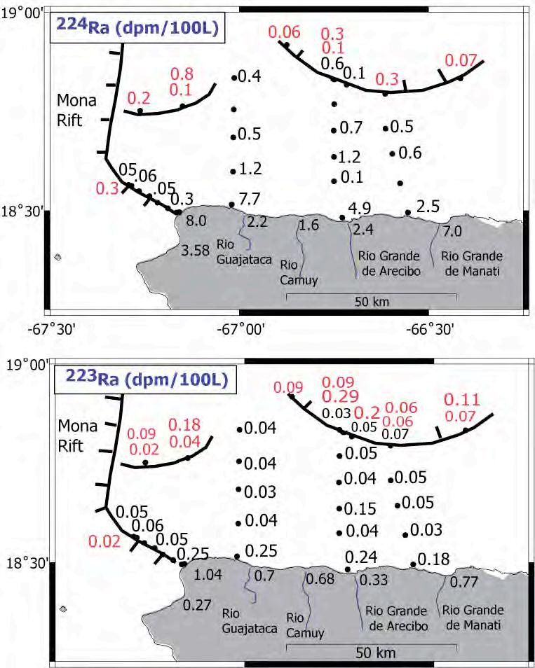
1600 yrs, r espectively) in de ep and shallow offshor e waters, and rive rs and springs o f northern Pue rto Rico Water sa mples fro m d epths of 3117 and 3469 m at one station within the Ar ecibo Amphitheater, a
giant (55 km- wid e) curved-shap ed sca rp c arved out of a northerly dipping ca rbonate platfor m on the northern Pue rto Rico m argin, had cl ear exc ess 223Ra an d 228Ra (Fig. 2; Appendix I ). Th e 228Ra activity at 3117 m was about an orde r of m agnitude higher than s a mples collected at simila r depths a f e w 100 k ms north of Pu erto Rico Th e 226Ra in this sa mple was abo ut 20% higher than expected The co mbination of strong signals of both long and short-lived isotopes m a de this our best case for rec ent radiu m additions due to deep fluid flo w. Additional deep sa mples f rom o ther stations also had cle ar excess signals of som e or all radiu m isotopes Surf ace water sa mples collected nearest the shore h ave excess activities of both these isotopes The sur fac e sa mples are , with one exc ep tion, enriched in 226Ra and 228Ra compa red to tropical Atlantic water This indicates radium additions by S GD are widespre ad offshor e the northern coast of Puerto Rico Ho wev er, analyses o f co astal springs, seeps, and rivers along the north co ast show relatively low activities of 223Ra and 224Ra that are similar to lo w s alinity samples we have m easured elsewh ere ( Appendix I ).
A deep-to wed ca me ra syste m was used to visually document se ep sites on the m argin Digital still images docu mented white halos, presum ably c arbonate deposits associated with seeps , a round a string of E- W trending fissures at the cro wn of an amphitheater-sh aped sc arp wh ere clea r radium excess was measur ed at station #13 (Fig 3) No che mosynthetic faunal com munities were observed at the seep sites
The TOWC AM system m easured nea rbottom turbidity and temper ature anom alies associated with these featur es ( Fig 4) Only one location along the amphitheate r provided visual documentation of a se ep site, although excess r adium activity was identified associated with a 100-200 m high cr escentic scarp on the e astern flank of the Mona Canyon (station #4). No r were seeps or seep deposits found associated with a 100-m high crescentic scarp located ~10 km southwest o f the amphitheate r he adscarp . This suggests that these sca rps have for med fro m te ctonic mech anisms r ather than erosion (dissolution) associated with deep fluid flo w.
Compilation of existing multibeam bathymetry and m arine g eophysical data for the project led to the identification of sever al mass- wasting f eatures in the c arbonate platform at the he ad of the Mona C anyon offshore NW Pu erto Rico ( Fig 5 ). One such feature has be en used to successfully model the tsunami run-up heights for the gre at 1918 Puerto Rico tsunami which, until recently, was assum ed to be caus ed by se afloor rupture associated with 1918 M7 3 earthquake ( Hornbach et al, sub mitted).
Obj ectives Acco mplishe d
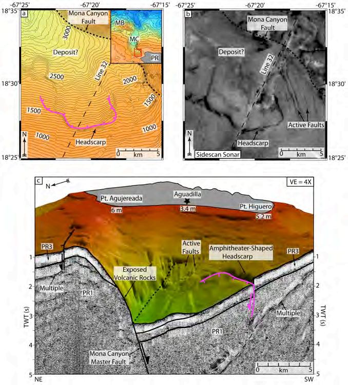
Fig 5 S o u th ern Mo n a Ca n yo n ma ss
wa stin g f ea tu re . a . Ba th ym et ri c -co n to u r
ma p o f so u th e rn Mo n a Ca n yo n in r eg io n
o f su b ma rin e ca b le b r ea k s ca u sed
d u rin g th e 1 9 1 8 ea rth q u a k e a n d t su n a mi
a s n o ted b y R eid a n d Ta b er , 1 9 1 9 G rid
in te rva l i s 1 0 0 m, co n to u r in t e rva l i s 5 0
m ; PR – Pu er to Ri co , MC – Mo n a
Ca n yo n , MB – Mo n a Blo ck b S id e s ca n
so n a r ma p o v er sa m e reg io n a s (a )
No te fa u lt s b r ea k in g su r fi cia l sed im en t s
a s f ir st d es c rib ed b y Ga rd n e r et a l
(1 9 8 0 ) c P e rsp ec ti ve v iew o f so u th e rn
Mo n a Ca n yo n sh o win g b a th yme tr y w ith
cu t-a wa y sh o win g EW9 6 0 5 S CS Lin e 3 2
o ve r sa me ma ss wa s tin g f ea tu r e.
This was an interdisciplinary pilot study to investigate the geological and che mical aspects of a unique deep-sea habitat on the northern ma rgin of the i sland of Pu erto Rico Th e objectives of our investigation were t wo-fold:
1) To d et er mi ne t he co mp
Pu er t o Ri co This objective has been m et We hav e me asured a ctivities of radium isotopes offshore northern Pue rto Rico that ex ceed background o ceanic v alues and indicate local additions of radium Such additions are likely due to fluids passing through rocks or sediments The source of these fluids m ay be submarine g roundwater discha rge (S GD) through shall ow p er meable sedim ents or discharg e through de ep formations ( cold seeps) . Excess activity of the short-li ved isotopes 223Ra and 224Ra indicate re cent additions of radium to the wate r Sur fac e wat er sa mples collected n earest the shore have exc ess activities of both these isotopes ( Fig. 2a ). The sur fac e sa mples a r e, with one exc eption, enrich ed in 226Ra and 228Ra compar ed to tropical Atlantic water . This indicates radi um additions by S GD a re widespr ead o ffshore the northern coast o f Pu erto Rico.
2) To co nd uct hi g h -r es o l ut i o n g eo l o g i ca l ma p p i ng o f t he a mp hi t h ea t er -s ha p ed s ca r p , up p er p l a t fo r m a nd d eb r i s s l o p es us i ng a t o w ed ca mer a s ys t em . This o bjective was met. In Septe mber 2006 we conducted a five-day cruise that included the us e of a d eep-to wed ca mer a system ( TOWC AM) to visually document se ep sites on the Pue rto Rico m argin. The TOWC AM was equipped with a C TD to me asure bottom tempe rature , salinity and turbidity during the to ws. Targ et ar eas o f TOWC AM d eployments we re
chosen on the b asis of areas of excess radium activity identified in the 2005 c ruise. These ar eas included a 20-30 k m-long 100-200m -high c rescentic-shap ed f au lt observed in the carbonate platfor m on the eastern fl ank of the Mona Canyon, the he ad wall and cr own o f the Are cibo Amphitheater , and a 100mhigh crescentic-shap ed f ault about 10 k m land wa rd of the cro wn of the a mphitheater. A total of seven cam era tows and eight C TD casts and water sa mpling stations at depths ranging fro m 1800 m to 3500 m whe re done during the cruise. Digital photos wer e mos aicked into Quick Time movies for eas e of vie wing and interpretation Geor efe renc ed still photos we re use d to docum ent fault locations and seep sites on high-resolution multibeam bathym etry DTMs
Discussion of Proje ct I mpacts and Pro duc ts
This preli minary study is a first step to wa rds evaluating the ground water contribution to the coastal waters off northern Puerto Rico This is an imp ortant and pra ctical issue that n eeds to b e addressed in ord er to qu antify the a mount of potential pollutants (e.g excess nutrients) that contaminate the coastal waters I f these onland springs and rivers ar e the sourc es of exc ess radiu m of fshore northe rn Puerto Rico, very l arge volu mes of S GD a re required to balance the coastal signal Th erefo re eff ective manage ment of runo ff and ground water qu ality onshore is impe rative given the potentially significant impact on the coast o cean environm ent
Although not typically thought to be tsunamigenic, giv en the steep and n arro w insular shelf, and the block failure of the c arbonate platfo rm that surroun ds the island, this study showed that subm arine landslides can pose a serious thr eat to the coastal com m unities of Puerto Rico. Th e c ause of the landsliding along the northern Pue rto Rico re mains spe culative. An approxi mate 100 m long E- W trending line of se ep sites was located 1-2 km south of amphitheater suggesting a c ausal r elationship betwe en fluid discharg e and we akening/dissolution of the ca rbonate platfor m . Ho wever , the extent of the seepage was ve ry limited and evidenc e of fluid flo w wa s not found along larg e offs et sca rps in the platform else where .
Re co mme nda tions
This was a pilot study that rev ealed a nu mber of s cientific questions that wer e beyond the scope of this project. We make the follo wing re com mendatio ns for r esear ch to b e pursued in further detail.
Ad d i t i o na l nea r s ho r e wa t er s a mp l i ng
Additional nearshor e, sh allow water sa mpling particula rly in the vicinity of the Rio Gr ande d e Ar ecibo rive r and estuary. Ou r r esults clearly indicate significant S GD contributions. Additional, detailed sampling, p erhaps using an autonomous unde r wat er vehicl e, along the northern Pu erto Rico shelf, would allo w sci entists to pinpoint the locations of the discha rge and sa mple fo r nutrients.
Nu meric al mod eling of the hydrologic flo w within the north coast aquife rs that incorpor ates the Ra fluxes m easur ed in this step is the n ext step to a ccur ately constrain the hydrologic budget for the region
Ad d i t i o na l hi g h-r es o l ut i o n ma p p i ng o f s h el f ed g e a nd a g e-d
Our study showed that subm arine l andsliding is a plausible mech anism for tsuna mi gene ration offshore Puerto Rico The insular shelf of Puerto Rico is very steep and given the rel atively high seismic activity, prone to mass- wasting Scientists have ve ry little understanding of the frequen cy of these events Dating of m ass- wasting deposits and additional high re solution mapping to identify past and potential failure sites will provide a better assessm ent of the pote ntial risk of tsunami for the coastal com munities of Pue rto Rico
Bibliography
Brooks, J .M ., M .C . Kennicutt II , C.R. Fisher , S .A. Mac ko, K. Cole , J .J. Childress, R. Bidigar e, and R.D. Vetter 1987 De ep-sea hydroca rbon seep co mmunitie s: Evidenc e for ene rgy and nutritional carbon sources S cience 238:1138-1142
Bugna, G.C., Chanton, J .P., Cable , J.E., Bu rnett, W.C . and C able, P.H. 1996. The importanc e of groundwate r discharg e to the m ethane budgets o f ne ars hore and continental shelf waters of the northeastern Gulf o f Mexico , Geo chimica et Cosmo chimica Acta. 60: 4735-4746
Cable, J E , W C. Burn ett, J P Chanton, and G L Weatherly 1996 Estimating ground wate r discharg e into the northeastern Gulf of Mexico using radon-222, Ea rth Plan et Sci Lett 144: 591-604
Cai W J and Y Wang, 1998 The che mistry, fluxes, an d sources of c arbon dioxide in the estuarine waters of the Satilla and Alta maha Rive rs, Georgia. Limnol Oceo 43 657-668
Carney , R.S. 1994 Consideration of the o asis analogy for ch emosynthetic co m munities at Gulf of Mexico hydro carbon v ents Geo- Ma rine Lett 14:149-159
Cathles, L M. 1990 Scales and effe cts of fluid flo w in t he upper crust, Scien ce. 248: 323-330
Grindlay, N , Mann , P., and Dolan, J , 1997 Rese arch e rs investigate submarine faults north o f Pu erto Rico, Eos Trans AGU 78: 404
Grindlay, N , Mann , P., Dolan, J and van Gestel, J-P , Neote ctonics and subsidence of the northern Pue rto Rico- Virgin Islands margin in response to the oblique s ubduction of high-standing ridges, GS A Special Pape r “ Active tectonics and seismic h aza rds of Puerto Rico , the Vi rgin Islands and o ffshore areas” , eds., P . Mann and C. Pr entice, 2005.
He ezen , B C., Nesterof f, V , Ra wson, M , Fre em an- Ly nde, R P 1985 Visual evidenc e for subduction in the western Puerto Rico Trench Geodynamiques d es C aribes, Symposium P aris, Editions Technip Hornba ch, M ., Mond ziel, S., Grindlay, N.R., P. Mann, and Frolich, C ., Did a subma rine slide trigger the great 1918 Puerto Rico tsuna mi? S ci en ce o f Ts u n a mi H a z a r d s , in revie w.
Hussain, N., T.M . Church , and G. Kim . 1999. Use of 222Rn and 226Ra to tr ace ground water discharge into the Chesap eake B ay M ar. Ch em 65: 127-134
Jickells T.D. 1998. Nutrient biogeoche mistry of the co a stal zone, Scien ce. 281: 217-222.
Kulm , L.D., Suess, E., Moore J., C arson, B., Le wis, B., Ritger, S ., Kadko, D., Thornburg , T. Embley, R . Rugh, W. Massoth, G., Langseth , M. Coch rane , G. and Sca mm an, R . 1986. Oregon subduction zone: Venting, fauna and carbonat es. Scienc e. 231: 561-566.
Land , L.A. and Paull, C.K. 2000. Sub marine karst b elt rimming the continental slope in the Straits of Florida, Geo- Marine Lett. 20 :123-132.
Moore , W.S . 1996. Larg e ground wate r inputs to coastal waters reve aled by 226Ra enrich ments, Nature . 380:612-614.
Moore , W. S. and Ralph Arnold. 1996. M easure ment o f 223Ra and 224Ra in coastal waters using a delay ed coincidence counter. J. Geophys. Res. 101:1321-1329.
Moore , W S. 1999 The subterr anean estuary: a re action zone o f ground water and se a water, Marine Chemistry. 65: 111-126.
Moore , W. S. 2000. Deter mining coastal mixing rates u sing radium isotopes. Cont. Shelf. Res., 20:19932007
Moussa, M T , Seiglie, G Mey ehoff, A , Taner , I 1987 The Quebradillas Li mestone ( Miocen e-Plioc ene), northern Pue rto Rico , and tectonics of the northe astern Caribbean m argin GS A Bull 99:427-439
Mullins, H.T., Gardulski, A. F. and Hine , A.C . 1986. C atastrophic collapse of the west Florida carbon ate platform ma rgin, Geology 14:167-170
Mullins, H T , Hin e, A C. 1989 Scalloped bank m argin s: Beginning of the end fo r c arbonate platforms ?, Geology 17:30-33
Mullins, H T , and 8 others 1991 Retr eat of ca rbonate platforms: Response to tectonic proc esses: Geology 19:1089-1092
Mullins, H T , Br een, N , Dolan , J , Wellner, R , P etruc cione, J , Gaylord, M , Andersen , B., Mellillo, A , Jurgens, A and Orange , D 1992 C arbonate platforms along the Southeast Bah am as- Hispaniola collision zone, M arine Geology 105:169-209
Or ange, D. and Br een, N. 1992. Th e e ffe cts of fluid esc ape on acc retionary wedges 2. Seep age forc e, slope failure, headless sub marine canyons and vents, J. Geophys. R es.97: 9277-9295.
Or ange, D , Green e, H, Re ed, D , Martin J , Mc Hugh , C., Ryan, W, M aher , N , Stak es D , B arry , J 1999 Widespr ead fluid expulsion on a translational continent al m argin: Mud volcanoes , f ault zones, headless canyons, and o rganic-rich substrate in Monter ey B ay, California , GS A Bull. 11: 992-1009.
Olu, K., Dupe rret, A., Sibuet, M . Foucher , J- P., and Fia la-Medinoi, A. 1996. Structure and distribution of cold seep com munities along the Peruvian active ma rgin: Rel ationship to geological and fluid patterns Marine Ecology P rogress Series 132 :109-12 5
Olu, K , S Lan ce, M. Sibuet, P. Hen ry, A Fiala- Médi oni, and A Dinet 1997 Cold s eep com munities as indicators of fluid expulsion patterns through mud volc anoes sea ward o f the Ba rbados a ccr etionary prism. De ep-S ea Res 44:811-841
Paerl H W 1997 Co astal eutrophication and har mful al gal blooms: Impo rtance of atmospheric deposition and ground water as ''ne w' ' nitrogen and other nutrient sources, Limnol Oceo 42: 1154-1165
Paull, C., Ke cker , R., Fre em en- Lynde, R P , Neu mann, C., Corso, W Golubic, S., Hook, J Sikes, E and Curray , J 1984 Biological co mmunities at the Florida Esc arpm ent res emble hydrotherm al vent tax a, Science 226:965-967
Paull, C. and Ne wm ann, A 1987 Continental margin brine seeps: Their geological consequ ences, Geology 15:545-548
Paull, C., Speiss, F., Curray , J and Twi chell, D 1990 Origin of Florida Canyon and the role o f spring sapping on the for mation of submarine box c anyons, GS A Bull.102:502-515.
Paull, C.K , Ussler, W , W S Boro wski, and F.N Spiess 1995 Methan e-rich plumes on the Carolina continental rise: Associations with gas hydrates Geolo gy 23:89-92
Paull, C.K., R . Matsumoto, P .J. Wallac e, et al. 1996. S ITE 996. P roc. ODP , Init. R ep., 164:241-275. College St ation TX ( Ocean Drilling Progra m) . Richardson, M .D., K.B . Briggs, F.A. Bo wles, J. H. Tietjen. 1995. A dep auperate benthic assemblage fro m the nutrient-poor sediments o f the Pue rto Rico Trench Deep- Se a Resea rch I 42:351-364
Rodriguez- Martine z, J . 1995. Hydrogeology of the Nor th Coast Lim estone Aquifer Syste m of Pu erto Rico. U.S. Geological Su rvey Water- Resour ces Inv estigation Rpt. 94-4249, 22p.
Sch wab , W.C ., Danforth , W., Sc anlon, K. and Masson, D. 1991. A giant sub marine slope failure on the northern insular slope of Pue rto Rico , Ma rine Geology. 96: 237-246.
Sibuet, M., and Olu, K. 1998 . Biogeography, biodiveristy and fluid dependen ce o f de ep-sea cold-se ep com munities at active and passive m argins. Deep- Sea Res, 45:517-567.
Sibuet-M ., Juniper -S- K., P autot-G.1998. Cold-seep ben thic com munities in the Japan subduction zones: Geological control of com munity developm ent. J . Mari ne R es.. 46: 333-348.
Stakes, D., Or ange, D., Paduan , J., Sala my, K. and Mah er, N. 1999. Cold-seeps and authigenic ca rbonate formation in Monter ey B ay, C alifornia, Ma rine Geology. 159:93-110.
Torr es-gonzale z, A 1983 Hydrologic study of the Rio Ca muy c ave syste m, Puerto Rico: Unive rsity of Puerto Rico unpublished m asters thesis, 115p.
Tuc ci, P. and Ma rtinez, M . 1995. Hydrology and si mulation of ground water flo w in the Aguadilla to Rio Ca muy ar ea , Puerto Rico US GS Water- Resour ces Inv e stigations Rpt 95-4028: 39p
Valiela , I , J Costa, K Fo re man, J M Te al, B. Ho wes , and D Aubr ey 1990 Tr ansport of ground waterborne nutrients fro m watersheds and their eff ects on coastal waters: Biogeoche mistry 10:177-197
Van Dover , C.L. Com munity structure in d eep-se a hydr othermal v ent mussel b eds. Marine Ecology Progress Series (in pr ess).
van Gestel, J P., Mann , P., Grindlay, N R., and Dolan, J 1999 Thr ee-ph ase te ctonic evolution of the northern m argin of Pue rto Rico as inf erred fro m an inte gration of seismic re flection, well, and outcrop data. Ma rine Geology 161:257-286
van Gestel, J P , Mann, P , Dol an, J , and Grindlay, N R 1998 Structure and tectonics of the upper Cenozoic Pue rto Rico- Vi rgin islands carbonate platfor m as deter mined from seismic re flection studies, J Geophys R es 103:30505-30530
von Hu ene, R . Bourgois, J., Miller, J. Pautot, G. 1989. A large tsunamogenic landslide and deb ris flo w along the P eru Tr ench, J. Geophys. Res . 94:1703-1714.
von Hu ene, R and Lalle mand, S 1990 Tectonic erosion along the Jap an and Pe ru conve rgent margins, GS A Bull 102:704-720
ch 2 0 0 5 Cr ui s e Sampl e col l. col l. Vol. Sal. ex Ra224
r-0 5
28-Ma r-0 5 14:5 3
6-0 28-Ma r-0 5 15:1 2 200 35. 79
1 7-0 28-Ma r-0 5 15:4 2 200 35 83 0 4 1
28-Ma r-0 5 16:0 8 200 35. 88 -0.0 5
r-0 5 16:2 5 200 35. 82 1.0
10-0 28-Ma r-0 5 16:4 7 200 35. 79
39 1.1 1 11-0 28-Ma r-0 5 21:0 8 200 35. 12 4.8 8
39
26
3 X 13-0 28-Ma r-0 5 21:2 8 200 35 78 0 6 3
19 3
1-Ap r 10:4
Ap p end i x I I I : St ud e nt s Th es es Ab s t r a ct s
He arne , Meghan , 2006, Investigation of sub marine lan dslide deposits along the northern margin of Pu erto Rico, Unpublished Master 's thesis, Unive rsity of North Carolina Wil mington, p 87.
ABS TR AC T
The seismogenic northeastern North Americ a- Caribbea n oblique-slip plate boundary includes the 8 5-km deep Pue rto Rico trench , 120 k m north o f the densely populated islands of Puerto Rico and the Virgin Islands Th e northern insular margin of Pu erto Rico, adjacent to the Puerto Rico tr ench, is chara cterized by fr equent seismi city, rapid Neogene tre nchward tilting, and ove rsteepened slopes Multibeam bathymetry , sidescan sonar , and single-chan nel seismic refle ction data r eveal extensive submarine landslide d eposits on the m argin that c an be traced upslope to t wo , larg e (up to 55km ac ross and 6 1 k m d eep) a mphitheater-shaped headsc arps along the edge of the Pu erto Rico – Virgin Islands (PR VI) carbonate platfor m. The cro wn o f the l arger , westernmost sc arp, incises the platfor m at 2600 mbsl, 40 k m o ff the north coast of Puerto Rico The associated landslide deposits extend up to 80 km trench ward , a ffe cting a total se afloor a rea of 4313 km2 S eismic refle ction data sho w a maxi mum debris deposit thickness of 2850 m The debris d eposit consists of multiple layers e ach approximately 200 m thick This suggests that slope failure m ay oc cur as multiple failure ev ents, r ather than a single, large catastrophic event Taking compa ction into consideration yields a volume for the amphitheater of 1378 km3, co mpar able to the cal culated co mpact ed landslide debris volume o f 1426 k m 3 Given these r esults, it is likely that the collection of deb ris layers is associat ed with the fo rm ation of the giant amphitheate r over time This also suggests that the debris is not b eing re moved by tr anslation or subduction, unlike other converg ent m argins Although the exact triggerin g me chanism(s) for slope f ailure is not kno wn, the west wa rd migration of the overthickend (20+ km ) sout heastern Baha mas Province bene ath the PR VI
margin is a likely c andidate. The present-day collision zone is interpret ed to be offshore north western Puerto Rico, an are a ch ara cterized by mid-slope uplift, anomalously high seismicity and cres centic c racks in the P R VI carbonate platfor m that are similar in size and shape to the a mphitheaters further east.
Evidence of multiple landslide deposits adjacent to the uplifted Mona Block and within the Mona Rift suggest that the d evastating 1918 tsunami could h a ve been gener ated by a seis mically triggered submarine mass wasting event. Moreov er, the proximit y of c rescentic-sh aped se afloor cra cks to the tectonically active Mona Rift make the m likely candida tes for sites of future bre aka way scarps and catastrophic landslides. A mode rn day inundation woul d have d etrimental eff ects on Puerto Rico whos e population has dram atically increas ed over the p ast cen tury to about four million.
Mondziel, Steve , 2008, Morphology, Stru cture and Te c ontic Evolution of Mona Canyon, Pu erto Ri co, Unpublished M aster's thesis, University of No rth C arol ina Wilmington, p 93.
ABS TR AC T
The Mon a Canyon is a z -shaped, 20-30 k m- wide, 140 k m-long, and 2-3.5 km -deep atypical submarine canyon that incises the Gr eater Antilles island arc off the north west coast of Pue rto Rico . This is the first study to systematically integrat e multiple sets of marine geophysical data , including multibea m bathymetry, sidescan sona r im agery , single- and multi-channel seismic re flection profiles, and earthquakes to evaluate the morphology, structure , and the tectonic evolution of the Mon a Canyon. The data suggest that the Mona C anyon is a half-gr aben stru cture that is controlled by the listric Mona Canyon master fault on the east side of the c anyon, and antithetic faults on the west side of the canyon.
The interpreted m arine g eophysical data l eads to a prop osed extensional model for the for mation of the Mona Canyon. A structural restoration of the c e ntral Mona C anyon per form ed in this study indicates that extension in the Mona Canyon appea rs to have initiated in the Middle Oligocen e, approximately 30 M a. This is in contrast to the pr evious estimate o f 1 2 Ma that was pr edicted using differential GPS vectors b etween Hispaniola and Puert o Rico Th e extension is proposed to have occurred over two phases Phase I o ccurr ed f rom the Middle Oligocene to Late Mioc ene, and was a slo w, initial stage of at le ast 1.66 k m. Phase II occur red from the Late Miocene to the Rec ent, and was a mor e rapid, late stage extension of at least 4 39 km , fo r a tota l minimum extension through the Re cent of 6 05 km.
On October 11, 1918, a M7 2 e arthquake near the south ern end of the Mon a Canyon gen erated a 4-6 m-high tsuna mi that inundated the north west co ast of Pue rto Rico , and clai med ov er 100 lives This study presents evidence for a 7 km - wide, 200 m -high a mphitheater-shaped heads carp in the southern Mona Canyon that is located in the sa me region as two submarine cable b reaks that occur red after the 1918 tsunami Num erical modeling pe rfor med using th e southern Mona Canyon mass wasting fe ature as a source m echanis m for the d eadly 1918 tsunami gener ates a wave that m atches well with the observ ed 46 m-high run -up, phas e, and timing