
University of Puerto Rico at Mayaguez Mayaguez, Puerto Rico


Project Summary
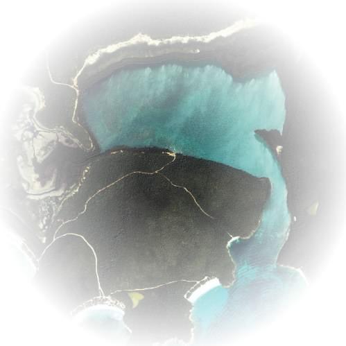
Puerto Mosquito Bay is one of the most magnificent examples of the world's few remaining bioluminescent bays. It lies within a basin formed along the southern edge of volcanic upland that comprises much of the bedrock of Vieques. Bioluminescence (the emission of light by living organisms) in Puerto Mosquito is caused almost exclusively by microscopic phytoplankton called dinoflagellates. This splendor of light may be in peril due to the unsustainable human activities in the surrounding uplands and along the shoreline of this shallow marine environment. With the increased tourist activities and the current development practices within the surrounding area, bioluminescence in this bay may be at risk in the near future resulting from excessive erosion and deposition of sediments and contaminants. The main objective of this work was to evaluate the relationship between physical parameters, sediment composition, and land use-land cover of the area by using traditional sampling methods and remote sensing. Sediment was collected monthly over an eight months period using three sediment traps located in the bay. Sediment composition, X-Ray Diffraction, sieving and serigraph analyses were part of the methodology. Temperature measurements were also registered at each trap The analyses demonstrate that 45% was carbonate material, 33% was terrigenous material, and 22% was organic material. It was also showed that the temperature can change over four degrees along the day in the sampled stations. However, a relationship between sedimentation and temperature was not found. The results from Puerto Mosquito Bay were compared with the same type of data collected during the same period in La Parguera Bioluminescent Bay in Lajas, Puerto Rico. In La Parguera the carbonate material was only 10%, while terrigenous material was 65% and the organic material was 25%. On the other hand the temperature follows the same trend as Puerto Mosquito. This study clearly demonstrates that La Parguera Bay received much more terrigenous material than Vieques Bay during the studied period, suggesting important differences in the processes affecting the sedimentation. In order to evaluate this problem IKONOS images were used to determine the changes in Land Use and Land Cover of the surrounding areas in both bays. The analyses showed that La Parguera has less vegetation and more human activity closed to the bay than in Vieques. Such condition in combination with the geology of the areas could explain the sedimentation trends found during this study. A baseline database has been created for Puerto Mosquito and La Parguera bays, but
further studies are necessary to fully understand the contaminant and erosion control in these bioluminescent bays.
Evaluation of Sedimentation Effects
Abstract - A comparative study between sediment of La Parguera bioluminescent bay and Puerto Mosquito Bay in Vieques was conducted during 2004. The main objective of this research was to compare the differences of sediment composition and the geology of the area. This study was undertaken to understand how natural and human induced factors may affect sediment composition and deposition and how that affects the quality and quantity of light in the water column of the bays. There is no information on how sediment affects the dinoflagellates that produce the bioluminescence in these bays. This study compared the differences in the sedimenthology of both bays and how it may affect the life of these organisms. Sediment was collected every 24 days over a 2 month period using three sediment traps in each bay. Sediment composition, XRD (DEFINE), sieving and sedigraph analyses were part of the methodology. The study showed that there is less suspended sediment in Puerto Mosquito and that the sediments are coarser in comparison to those in La Parguera Bay.
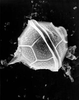
Introduction - Dense blooms of bioluminescent dinoflagellates occur sporadically in tropical latitudes around the world. In lower latitudes, as a result of unique topographic and meteorological conditions, certain bioluminescent bays exhibit persistent high concentrations of bioluminescent dinoflagellates (Walker, 1997). Bioluminescence in these bays is mostly produced by the unicellular dinoflagellate, Pyrodinium bahamense (Figure 1). There are several bioluminescent species in both bays, but Pyrodinium is the dominant light producer. Several theories have been developed of why these organisms glow, but it is generally accepted that it is a type of primitive defense mechanism. They do not have control over their luminescence, they simply emit a bright glow whenever they are agitated or disturbed. For a single-celled creature, the brief flash may make them seem larger than they really are and scare away possible predators. These organisms requires specific environmental conditions for living and reproduction. There are several factors that account for high concentrations of dinoflagellates in these bays; it should be surrounded by mangrove trees, be remotely located with a narrow
entrance, ability to maintain warm water temperatures and calm water (Seixas, 1988). The tourist exploitation of the places where these organisms live is causing irreversible damage (Nixon, 1995). Waves generated by boat traffic, alter movement dynamics in waters no adapted to the natural influence of wind generated waves (Nemeth, 1998), with direct effects on these phytoplanktonic organisms due to the light reduction caused by the re-suspension of sediments (Vermaat y De Bruyne, 1993). These effects could be significant in shallow bays with fine sediments (Smart et al., 1985)
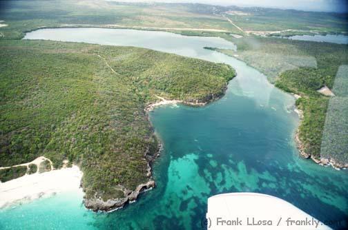
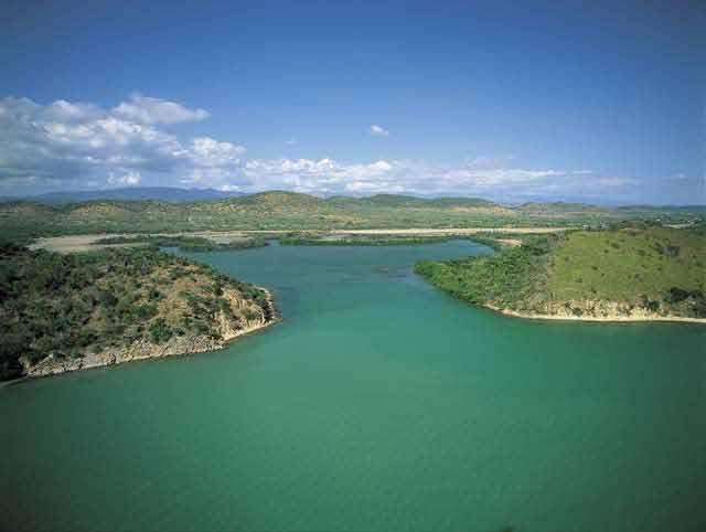
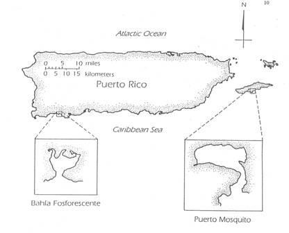
La Parguera bioluminescent bay is located along the southwest coast of Puerto Rico between 17˚58’ N and 67o10’ W and has an approximate depth of 4.5 meters in the inner bay and approximately 2.3 meters at the mouth of the bay. Puerto Mosquito bay is located along the south coast of Vieques between 18˚6’ N and 62˚ 26’ W and has a depth of 3.9 meters in the inner bay and 1.8 meters at the mouth (Figure 2).
La Parguera Bay has shown a decrease in its bioluminescence by approximately 80% in the past 10 years compared with Puerto Mosquito (Walker, 1997), which still has a magnificent bioluminescence. A comparative study of these two bioluminescent bays was conducted in 1996 by Alfredo Sanjuan and Juan Gonzalez. The main objective of that research was to determine how boats that enter La Parguera bay move sediments, and how this affects the bay. They found changes in sediment where the upper layers represent accumulations of finer sediments (particulate organic material) in cores collected when compared to cores collected in the deeper part of the bay that present the normal conditions of the bay with coarser sediments composed mostly of diatoms, spicules, ostracods, marine algae and mangrove leaves (Sanjuan and Gonzalez, 1996).
Marine sediments can be divided into three categories, based on their composition and mode of deposition origin. Sediment composition provides important information about the origin of individual grains, and energy levels during transport and deposition, especially in areas dominated by clastic sediments of terrigenous origin Clastic marine sediments can be divided into two broad categories; terrigenous and carbonate. The processes that are responsible for their formation and deposition can be different. Terrigenous sediments are most often of silicate origin They are derived from the erosion of upland or coastal areas and transported over considerable distances to their ultimate environment of deposition. Terrigenous sediments can also contain eroded carbonate that has been lithified and uplifted. A very clear relationship exist between grain size and energy level, coarser sediments generally reflect higher energy, while quieter areas are dominated by mud. Abrasion during transport might significally reduce the size of some rock fragments and may even be responsible for total destruction of others (Friedman, 1978). Suspension and transportation of sediments depends on the size and/or weight of the particle.
In the marine environment carbonate sedimentation depends on factors such as, temperature, salinity, water depth, nature of water currents, light penetration due to water turbidity (Miall, 1984). Under optimum conditions calcium carbonate accumulation can be extremely rapid, such conditions include, warm, clear, shallow water of normal marine salinity. Carbonate grains are controlled by the skeletal architecture of the organisms from which the
organism is derived. Physical breakage by abrasion in agitated waters is one of the factors that break carbonates into lime mud.
The sorting in carbonate environments can be complex. The variable grain size and the high porosity of some particles (Halimeda or foraminifera with natural pores and chambers) can make them more susceptible to transport than terrigenous sediments. Terrigenous sediments are derived from the breakdown of crystalline volcanic rocks that are deposited as sedimentary rocks that are again eroded to provide grains, material that is deposited as marine sediments. The principal source of terrigenous marine sediments is river discharge. Rivers transport more than 18 x 109 metric tons of suspended solids to the world’s oceans annually (Holeman, 1968).
Suspended sediments affect the amount of light that penetrates the water column; therefore it is an important factor in the life of these organisms because of the need of light for photosynthesis. The objective of this research is to measure the impact of sediment movement, caused by different natural and human induced changes in the bays and how they are related to the dinoflagellate population.
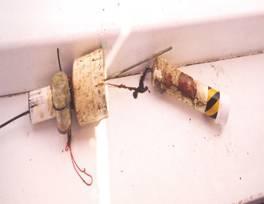
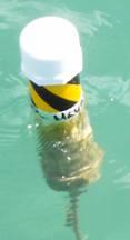
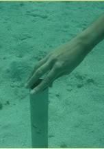
Methodology - Sediment traps were made with 15cm wide and 15cm long PVC tubes with a rod of 2cm wide and 1 meter long for stabilizing the trap in the bottom (Figure 3). For the second part of the project sediment traps were made from 20cm wide and 20 cm long PVC tubes. These traps were placed at three different sites in both bays. The sediment was collected every 24 days during an eleven months period, and dried in the laboratory. The weight of each sample was calculated by separating the samples of the different traps into three groups.
The samples for X-Ray Diffraction (XRD) analyses were dried and pulverized and placed in sample holders. XRD analysis is a technique based on differential passage of X-ray radiation through a sample onto a special film.
Sieve analysis measures grain diameter by allowing sand to settle through a set of sieves. Each sieve is a cylinder floored with a wire-mesh screen with squares apertures of fixed dimensions (Prothero and Schwab, 1999). Phi units express grain size as the negative logarithm of grain diameter in millimeters to the base 2. Wet sieving was used after mixing the sample with sodium methaphosphate at 0.5%. This process was used to separate the clay from sand. The samples were washed and dried for normal dry sieve analysis. Sediments larger than 4 Φ were separated and taken to the sedigraph machine. Sedigraph is an x-ray process that “sieves” sediments > 4 Φ using sodium methaphosphate to separate clay from sand. Sorting was used to express the number of significant size classes in the samples; this may reflect variations in the velocity and the ability of a particular process to transport and deposit (Prothero and Schwab, 1999). Skewness was measured to understand the symmetry of the distribution. With negative skewness, coarser grains are less well sorted than finer grains. With positive skewness finer grains are more poorly sorted than coarser grains. Transporting agents differ in their ability to entrain, transport and deposit coarse versus fine material (Prothero and Schwab, 1999).
For sediment composition, the samples were washed with Clorox, washed, dried and weighed for second time in order to remove the organics. Then it was washed with HCl at 10% in order to remove the carbonates The sample was dried and weighted again. Only terrigenous materials remained after this process.
Temperature was measured every two hours using HOBO thermistors.
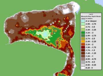
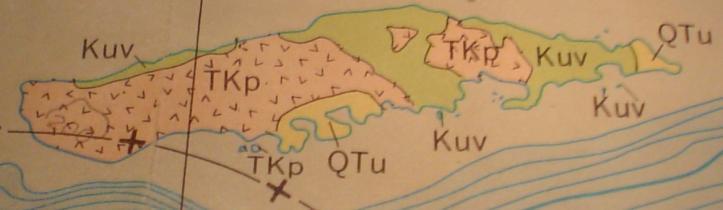
Sediment mineralogy of the bay was compared to the geology of the area that surrounds it using geological maps and rock samples to understand the origin of the minerals present in the sediments.
Results and Discussion - The amount of sediment collected in La Parguera was much higher than the one collected in Vieques (Figure 4), except for the sample of September 04, which was higher in Vieques. This anomaly was related to tropical Storm Jeanne, which brought approximately 27 inches of rain to Vieques Island, while in La Parguera weather conditions were
normal. It has been suggested that a storm can move more sediment during one episode than the one transported in a year.
Collected Sediment
Figure 4: Average amount of sediment collected during the study period.
Boat traffic in La Parguera is significally higher than in Vieques (Figure 5). This could be responsible for re-suspending the fine layer of sediments that leads to sediment abrasion It is important to understand that continuous abrasion of the sediments may cause carbonate particles to become lime mud (Prothero and Schwab, 1999), a possible explanation for the change in sedimentation in La Parguera bay.
Bioluminescence has decreased more than 80% in the past 10 years in La Parguera bay (Gonzalez, Personal Communication), while in Vieques Pyrodinium bahamense has maintained high populations throughout this time period (Walker, 1997).
As we can see in Figure 6, the sediment composition in Vieques Bay are mostly coarser grained carbonates that are not easily re-suspended, while in La Parguera we have mostly terrigenous sediments. Average grain Composition
La Parguera bay is characterized by very fine sediments between 2Φ and 5Φ, while in Vieques they are between -1Φ and 2Φ (Figure 7). Therefore, La Parguera sediments are terrigenous mud and Vieques sediments are coarse carbonate sand. Terrigenous sediment distribution in the marine environment is primarily a function of the interaction between the strength of waves and currents and the size of individual sediment grains. Although produced locally, carbonate sediments are also redistributed by these same processes. Sediment particles respond to hydraulic forces such as shear and lift, whose effects are related to current speed, particle size, shape and density (Morelock, internet information).


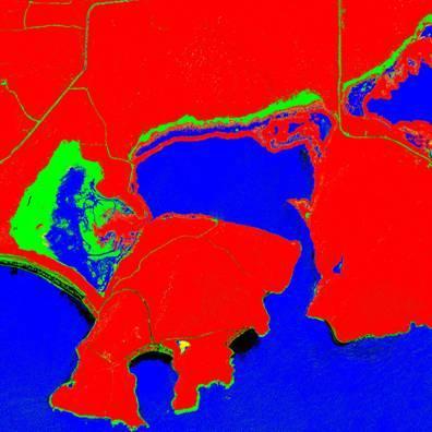
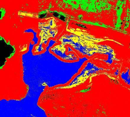
There is a difference in the geology of the area that surrounds the bays as we can see in Figure 8. La Parguera Bay is surrounded by Parguera Limestone which is volcanic rocks and chert with minor serpentinite and amphibolites which when eroded become terrigenous sediment that is exactly what we found in the sediment composition of this bay and in the XRD analysis. But also we found Basaltic andesite, beach deposits and alluvium which is clay, silt, sand, gravel and sparse lenses of coarse grained light-gray bioclastic limestone which consist of skeletal debris including fragments of mollusks, solitary corals, and larger foraminifera. In 1961 Margalef found more carbonates in this same area, which suggests that the continuous abrasion of the sediments throughout the years accounts for fewer carbonates and more terrigenous mud.
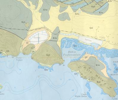
On the other hand, Vieques is mostly composed of sedimentary deposits, undivided marine limestone, calcarenite, sandstone, shale, marl, chalk, sand and clay; and alluvial landslide beach, dune, swamp, marsh and reef deposits. This explains the amount of carbonate fund in the samples.
Conclusions - The objective of this research was to examine the differences between sediment composition and its relationship with the geology of the area for both bays. We found differences in sediment size and mineralogy as well as differences in sediment suspension between the two bays. The difference in the sediment mineralogy may be related to the distinct geology of each area. Different processes like abrasion may be contributing to the process of evolution of carbonates to lime mud.