A Sedimentary Record of Marine Flooding Events from Coastal Salt Ponds, Southwest Puerto Rico
UPR Sea Grant Project# R-94-2-10
Final Project Report
Submitted to University of Puerto Rico Sea Grant College Program 27 April 2015
Clark E. Sherman Department of Marine Sciences
University of Puerto Rico – Mayagüez
Project period: 1 February 2010 to 31 December 2014 (including no-cost extensions)
Executive Summary
Summary of Impacts and Contributions
Objectives
Objective 1 – Document the Chronology and Frequency of Marine Flooding Events
The documented stratigraphy reveals a dramatic change along this coastline involving an abrupt transition from normal marine conditions to restricted hypersaline lagoons. Radiometric data indicate that this transition first occurred ~1400-1700 yr BP, with a second transition occurring ~400-500 yr BP. The sharpness of each of these shifts suggests that they may have been event driven. A shell-hash layer dated at ~600 yr BP indicates an overwash event that may have been responsible for the second transition documented in the core stratigraphy. Current salt pond settings are geologically quite young and seem to have been established only ~400 yr BP. Within the salt pond sediments, thin carbonate sand layers in some cores suggest overwash events. However, because they are so recent, their precise age cannot be established by radiocarbon methods. It appears that there may been 2-3 overwash (marine-flooding) events over the last ~400 yr.
Objective 2 – Document the Physical Character and Composition of Marine Flood Deposits
The character and composition of all primary facies have been documented to determine deposition setting and environmental changes over time as well as differentiate potential washover deposits. Three primary facies have been described, the Halimeda facies, peat facies, and organic-rich mud facies. Potential washover deposits occur as thin (~1 cm) layers of coarser marine grains consisting primarily of mollusk fragments (i.e., shell hash) within the organic-rich muds of Unit I.
Objective 3 – Correlate Marine Flood Records with Historical and Other Geologic Records
The most striking feature of the documented stratigraphy is the abrupt transition from normal marine conditions to mangrove swamp and isolated hypersaline pond. Radiocarbon ages
indicate that this transition occurred at ~1400-1700 yr BP and may have been relatively sudden. A reconstruction of hurricane activity based on cores from Laguna Playa Grande, Vieques, PR, identifies a period of intense tropical storm activity occurring between ~2500 to 1000 yr BP, with a particularly large storm occurring ~1500 yr BP. This period of intense hurricane activity coincides with abrupt and significant changes occurring along the coast of southwest Puerto Rico. Additionally, the Vieques record also documents a prominent event occurring at ~500 yr, which roughly corresponds to the second transition noted in the Cabo Rojo record. Thus, timing of environmental changes documented in the salt ponds of southwest Puerto Rico may reflect intervals of intense hurricane activity.
Other geological records of interest for comparison include elevated shoreline deposits near Rincón, PR with ages that range from ~1350-1900 yr BP. Recent tectonic movements have been proposed as an explanation for these deposits. Records from the southern Caribbean suggest the occurrence of three large tsunami events occurring at ~500, 1500 and 3500 yr BP. Interestingly, the timing of the younger two tsunami (i.e., 500 and 1500 yr BP) roughly corresponds to the timing of stratigraphic/environmental changes in our cores from Cabo Rojo.
Advancement of the Field
This study documents geologically recent and significant changes occurring along the coast of southwest Puerto Rico. Based on comparison with other records, timing of these changes may reflect intervals of increased hurricane activity. Other possible causes could include coseismic displacements or tsunami strikes. The current hypersaline pond environments and geologically young, becoming isolated from the adjacent ocean only ~500 yr BP. Regardless of the cause of the documented changes, this work highlights the dynamic nature of this coast and its acute sensitivity to environmental changes. Future tropical cyclones and projected sea-level rise over the coming century should be expected to have a significant impact on this delicate system.
Impacts and products
Students
Joel O. Fernández Ramos (MS candidate)
Department of Marine Sciences, University of Puerto Rico at Mayagüez Email: joel.fernandez@upr.edu
Total Salary (SG Funds): $37,350; September 2010-May 2013; 20 hrs/week
Presentations
Fernández, J. and Sherman, C., Depositional history and coastal evolution of salt ponds, southwest Puerto Rico. 62nd Annual Meeting of the Southeastern Section of the Geological Society America, San Juan, Puerto Rico, 20-21 March 2013.
A record of late Holocene coastal evolution and relative sea-level change from a coastal salt pond, southwest Puerto Rico. UPR Sea Grant Fifth Applied Research Symposium, Mayagüez, Puerto Rico, 20 February 2014.
[2]
Sherman, C. and Fernández, J., A record of late Holocene coastal evolution and relative sea-level change from a coastal salt pond, southwest Puerto Rico 2014 GSA Annual Meeting, Vancouver, British Columbia, 19–22 October 2014.
Final Report Narrative
Statement of Problem
Tropical cyclones and tsunami represent the preeminent coastal hazards in Puerto Rico. Lying directly within the Caribbean hurricane belt, a hurricane or tropical storm passes over the island or its adjacent coastal waters about once every four years (Bush et al., 1995). Puerto Rico also lies within a tectonically active region subject to numerous local and regional earthquakes and submarine landslides with the potential to generate tsunami (Morton et al., 2006) Both hurricanes and tsunami can generate devastating coastal marine flooding events that inundate low-lying coastal areas with seawater causing widespread property damage and potentially loss of life. Though potentially devastating, strong hurricanes and large tsunami are infrequent events in Puerto Rico on human timescales and often outside the collective memory of community officials, planners and the general public. Instrumental records are generally short and historical accounts are often vague and insufficient to gain meaningful information on the characteristics or patterns of these events. It is therefore important to identify proxy records of past storm or tsunami activity in order to establish patterns in their occurrence, frequency and magnitude. This will provide important information to various stakeholders in coastal areas by providing examples of past events in the region and help in assessing the vulnerability of the area to hurricane and tsunami activity.
Coastal marine flooding events generated by either tropical cyclones or tsunami can transport large amounts of sediment inland where it can be preserved as a record of the event (Donnelly, 2005; Donnelly and Woodruff, 2007; Morton et al., 2006; Woodruff et al., 2008). In particular, backbarrier lagoon or tidal flat settings are especially useful as they represent settings with high preservation potential of marine flooding deposits. During an event, nearshore environments, beaches or low dunes along the shore provide a source of coarser-grained sand and carbonate shell material and the low energy lagoon or tidal flat environment serves as a trap for the high-energy marine sand overwash deposit (ibid.). The coarse-grained marine flood deposits contrast sharply with the fine-grained, organic-rich mud and peat deposits typical of lagoonal and tidal flat settings. Thus, marine flood deposits are easily identifiable in the sedimentary record. Therefore, coring in these settings can provide long-term, millennial-scale records of coastal marine flooding events that can serve as a proxy of past tropical cyclone and tsunami activity.
Cabo Rojo, the southwestern point of Puerto Rico, is an ideal setting to conduct such a study. Several backbarrier hypersaline lagoons, or salt ponds, occupy the low-lying coastal regions around the rocky headland. During normal conditions, the lagoons are isolated from the open ocean by narrow beaches and dunes. During marine flooding events, the beaches and dunes can be overtopped and coarse, skeletal sands transported into the low-energy lagoons leaving behind a record of the event. A coring study of the Cabo Rojo lagoons builds upon previous work in Puerto Rico and reveals an important new millennial-scale record of coastal changes that can improve upon risk assessments of the region.
Methods Used
Cores were recovered using Wildco stainless steel hand corers of 1.2 and 2.4 m lengths. Core material was recovered in plastic liner tubes with an internal diameter of 48 mm. After recovery, cores were split lengthwise and their sedimentology and stratigraphy described with regard to sediment type, grain size, color and the character of transitions between sedimentary layers. Macrofossils were also identified to assist with environmental interpretations. Bulk carbon composition of core material (total carbon, total inorganic carbon and total organic carbon) was determined by carbon coulometry. Coulometric results are converted to percent calcium carbonate, percent organic material and percent other. These data are important to characterize stratigraphic units as well as document the nature of transitions. Mineralogy of sediments was determined by x-ray diffraction and aided in determining their provenance as well as screening samples for radiocarbon dating. Samples of inorganic carbonate (mollusk shells) and organic carbon (mangrove roots) were selected to determine, or bracket, the age of core materials. Numerical ages of material are determined using radiocarbon (14C) methods at the National Ocean Sciences Accelerator Mass Spectrometry Facility at Woods Hole Oceanographic Institution.
Results and Findings
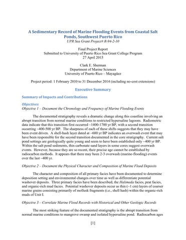
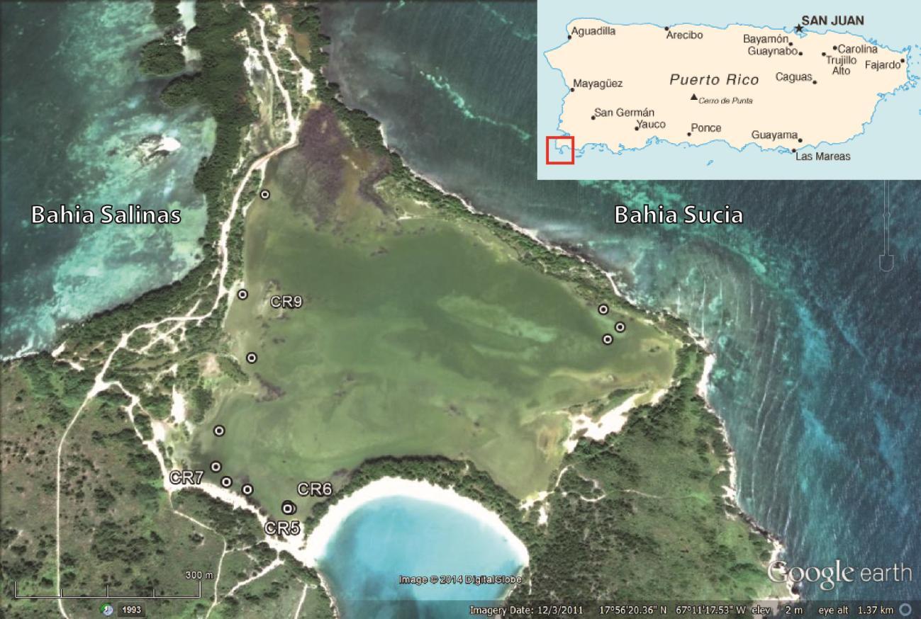
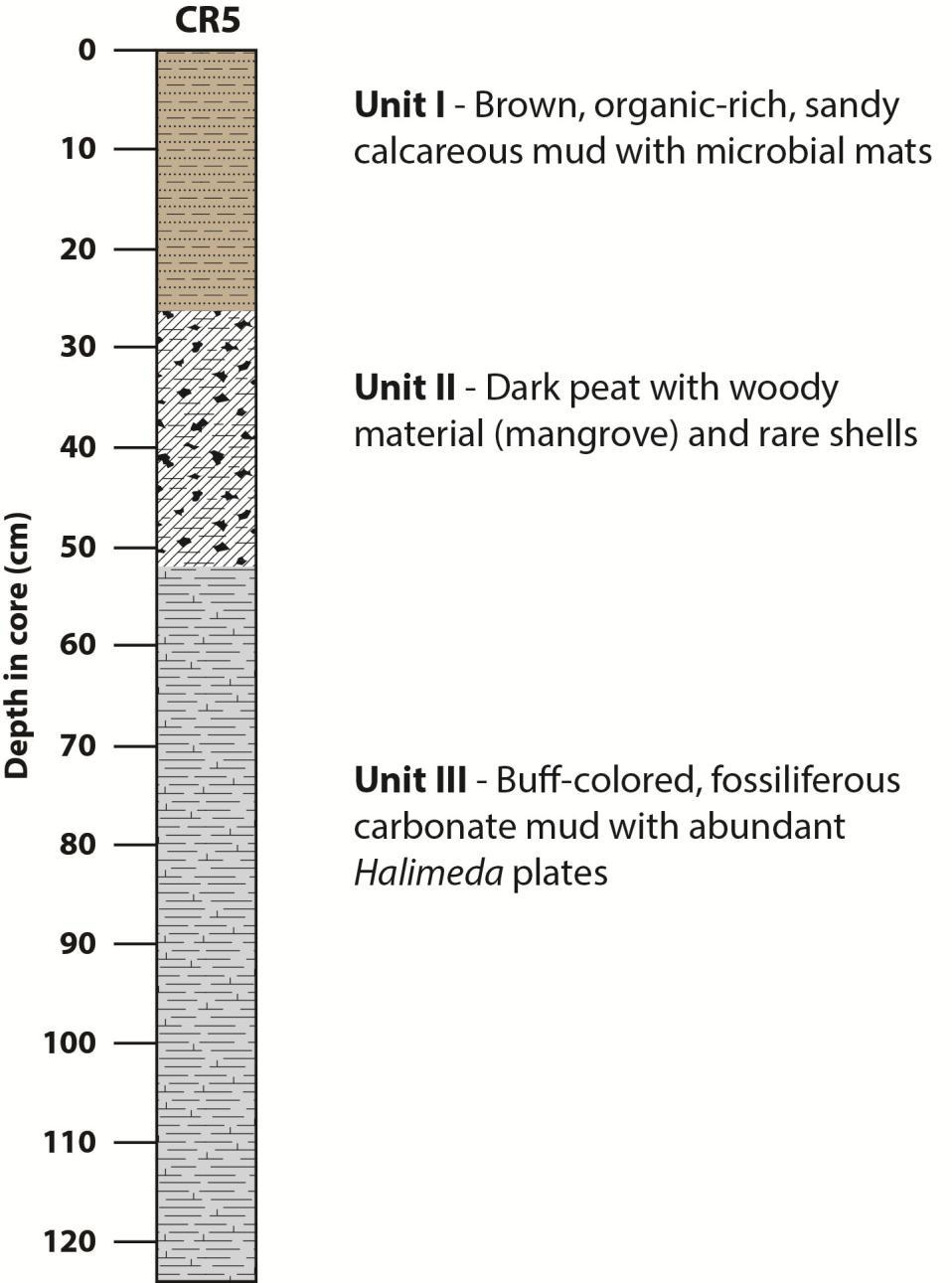
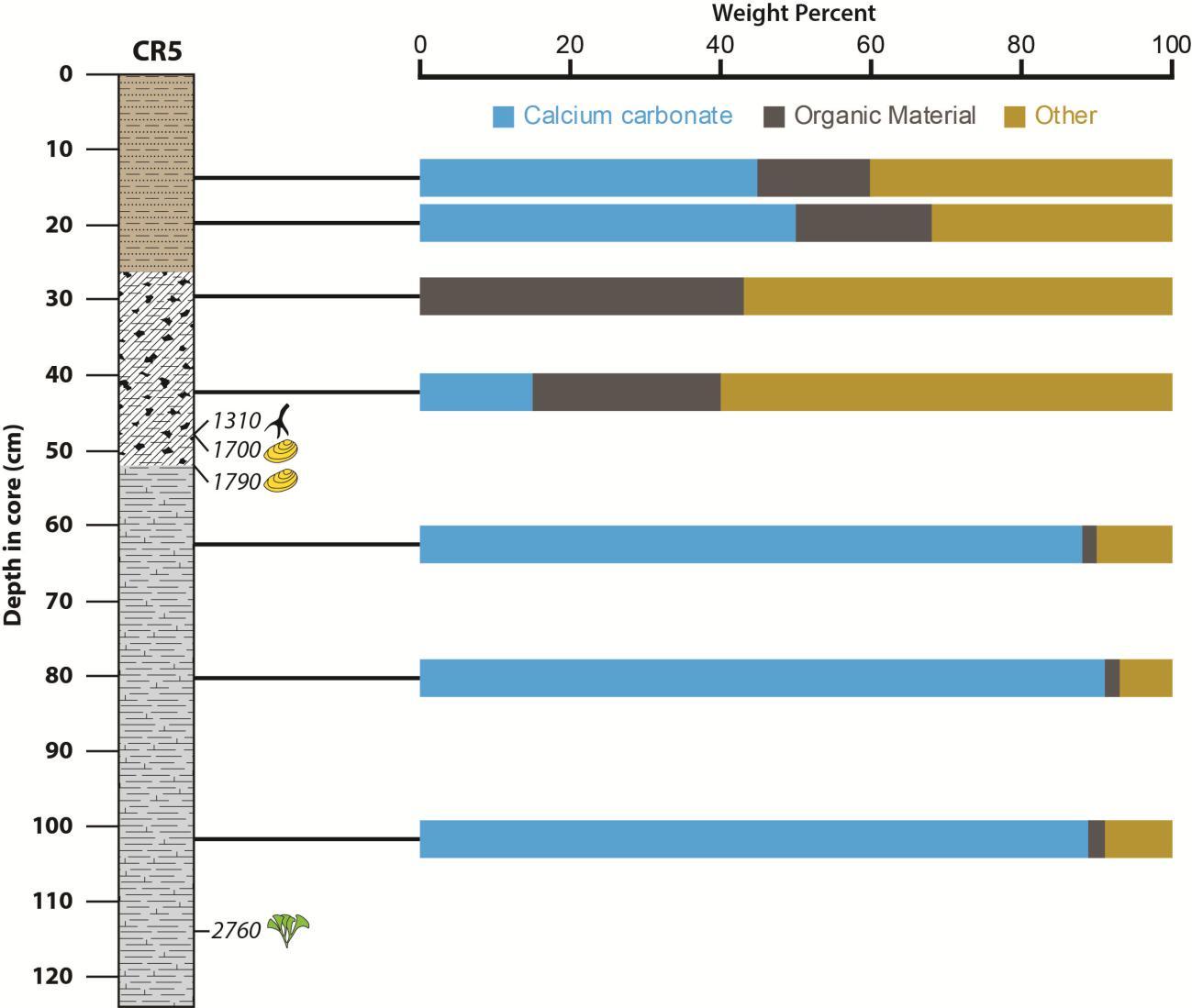
Work focused primarily on coring of the southernmost coastal salt pond at Cabo Rojo. Fifteen sites were cored along the margins of the pond (Fig. 1). Cores penetrated to a depth of ~2.4 m below the sediment surface. The stratigraphy and sedimentology was described. In addition, macrofossils, primarily mollusks, were identified to aid in environmental interpretations. All cores display a similar stratigraphy consisting of three primary units or facies (Fig. 2). The uppermost unit, Unit I (organic-rich mud faces), extends from the sediment surface to depths of ~20-30 cm (not corrected for compaction) and consists of a brown, organic-rich, sandy calcareous mud with microbial mats. This material is consistent with the current hypersaline pond environment. Unit II (peat facies) extends from ~25-50 cm (not corrected for compaction) and consists of a dark brown to black peat with woody material (mangrove) and rare shells. This material probably accumulated in a mangrove swamp similar to those currently found around the margins of the pond. Recovery of mangrove peat in all cores, suggests that mangroves were either more extensive in the recent past or have slightly shifted their location in response to environmental changes and establishment of the pond. Unit III (Halimeda facies) extends from ~50 cm (not corrected for compaction) to the base of the cores and consists of a buff-colored, fossiliferous carbonate mud with abundant plates of the calcareous green alga Halimeda. This material is indicative of open to semi-protected, shallow, normal marine conditions. Similar sediments are currently accumulating in adjacent nearshore coastal areas. In some cases, the lowermost unit of the cores consists of dark yellowish brown, muddy carbonate sand, suggesting slightly higher energy conditions than the Halimeda facies. Additional information on grain size and bulk carbon composition is shown in Figures 3 and 4.
The most striking feature of the documented stratigraphy is the abrupt transition from Unit III/Halimeda facies to overlying mangrove peats and organic-rich muds. The Halimeda facies is in stark contrast to the current environmental setting and suggests that the pond was previously an open or semi-restricted marine lagoon connected to the adjacent Caribbean. The sharp contact between the carbonate mud and overlying peats and organic-rich muds suggests that the transition from open lagoon to mangrove and restricted salt pond may have happened relatively quickly. Radiocarbon ages of mollusk shells, Halimeda plates and mangrove wood
[4]
sampled from the three primary facies provide an indication of the timing of these transitions (Table 1, Figs. 5 and 8). Radiocarbon ages of material from the bottom of cores indicate that the recovered records extend back to ~ 2600 to 2800 yr BP (yr BP = calendar years before present, where present is defined as 1950 AD). Ages of the carbonate material indicate that normal marine conditions existed from at least ~2800 yr BP to ~1400-1700 yr BP. At this time the lagoon was abruptly isolated from adjacent coastal waters. Following isolation of the lagoon, deposition of mangrove peats began. Ages of woody material/mangrove root from the base of this layer display a broad range of ages from ~600 to 1300 yr BP. These ages may reflect a significant lag time between isolation of the lagoon and establishment of mangroves as well as some loss or reworking of materials. Mangroves appear to have dominated up until ~400 yr BP when there was a transition to the current hypersaline pond conditions. Overall, this stratigraphy is reflective of a relative sea level fall and progradation of the shoreline.
With isolation from the adjacent coastal ocean at ~1400-1700 yr BP, the environment became conducive to the recording of marine flooding events and overwash. Within the mangrove peats (Unit II) that were deposited from ~1300 to 400 yr BP, there are only a few isolated marine mollusk shells and no distinct event deposits. The current hypersaline pond appears to have been in existence for the last ~400 years (Unit I). Sand and silt-sized skeletal carbonate grains of marine origin, such as Halimeda plates, foraminifera and mollusk fragments, are common within the organic-rich pond muds. This suggests that there is regular connection and influx of sediments from the adjacent coastal ocean. It may also be an indication that the
[5]
pond sediments are fairly well mixed. Although marine sediment grains are common in the pond muds, distinct event layers of marine origin traceable among the cores are not as evident. Within several cores, there are thin (~1 cm) layers of coarser marine grains consisting primarily of mollusk fragments. These may represent larger overwash events. Still, these are not welldefined or traceable among the cores, consistent with washover being deposited as fans rather than a broad sheet. Using these layers as a rough approximation of overwash, it appears that ~23 larger overwash events have occurred in the last ~400 years. Radiocarbon ages of emergent coral cobbles and mollusk shells found just adjacent to the pond on the western barrier that separates the pond from Bahía Salinas are all less than ~200 yr BP and consistent with recent overwash (samples CR-C1, CR-C3, CR-M1; Table 2).
In addition to the primary study site, two cores were also collected from Fraternidad, the (managed) salt pond ~2.5 km to the north (Fig. 6). These cores recovered slightly different facies, though the timing of transitions was similar to those found in the southernmost pond (Table 3 and Fig. 7). The base of the longer core consists of an organic-rich peat interlayered with several centimeter-thick layers of shell hash. This may represent initial flooding of the coastal zone with rising sea level ~4,000 years ago. Overlying the peat and shell hash is a dark gray fossiliferous carbonate mud, indicative of normal marine conditions. This is overlain by a lighter gray carbonate mud with very sparse fossils and suggests isolation of the pond ~15001600 yr BP. Another shell hash layer caps the carbonate mud and suggests an overwash event occurring at ~600-700 yr BP. This is overlain by organic-rich muds and microbial mats, reflective of current conditions. Thus, timing of transitions in Fraternidad are similar to those that occurred in the southernmost pond indicating similar causes.
4. Representative bulk carbon composition of the three primary facies.
Overall, the stratigraphy of both ponds is reflective of a relative sea level fall and progradation of the shoreline. A relative fall in sea level is somewhat problematic as most accepted sea-level curves for this time period indicate sea level slowly rising towards its current position. Isolation of the pond may have been the result of changes in sedimentary dynamics and barrier development associated with slowly rising sea level. However, there are other nearby records that indicate at least local sea-level and coastal change and this time. USGS workers have identified elevated shoreline deposits near Rincón, PR with ages that range from ~13501900 yr BP. Recent tectonic movements have been proposed as an explanation for these deposits. In addition, we have dated coral and bivalve samples (PH-C1 and PH-M1) from an extensive emergent shell deposit that occurs along the landward margin of coastal mangroves ~10 km to the east of our primary study site. Both samples have ages of ~1900 yr BP (Table 2, Figs. 6 and 8). Ages of these deposits and those described in Rincón overlap with the timing of
deposition of the marine facies in both pond records. All of these records are consistent with relative sea-level fall and shoreline progradation and indicate recent and significant changes along the coast of western and southwestern Puerto Rico.
It may also be plausible that barrier formation and isolation of the ponds was a result of large-scale depositional events associated with tropical cyclones or tsunami. The stratigraphy from both ponds displays an abrupt transition from normal marine to isolated conditions. Radiocarbon ages indicate that this transition occurred at ~1400-1700 yr BP and may have been relatively sudden. A reconstruction of past hurricane activity based on cores from Laguna Playa Grande, Vieques, PR, identifies a period of intense tropical storm activity occurring between ~2500 to 1000 yr BP, with a particularly large storm occurring ~1500 yr BP (Donnelly and Woodruff, 2007). This period of intense hurricane activity coincides with abrupt and significant changes occurring along the coast of southwest Puerto Rico. In a core record from Laguna Grande, (northeastern) Puerto Rico, Lane et al. (2013) cite evidence of frequent breaches of the barrier separating Laguna Grande from the adjacent ocean occurring about 1550 yr BP. The Vieques record also documents a prominent event occurring at ~500 yr BP, which roughly corresponds to the second transition noted in the Cabo Rojo record (Donnelly and Woodruff, 2007). Thus, timing of environmental changes documented in the salt ponds of southwest Puerto Rico may reflect intervals of intense hurricane activity.
In the Fraternindad cores (Fig. 7), the uppermost shell hash layer, indicative of overwash dates to ~600-700 yr BP. No younger overwash deposits were noted. Radiocarbon ages of cores from the southern pond indicate that the current hypersaline pond conditions were established only about 400 years ago (Figs. 5 and 8). While coarser sediments are found within the salt pond muds, they are restricted and not traceable among all of the cores. If these are indicative of overwash events, it indicates that event sediments were deposited as isolated fans rather than a broad sheet over the pond floor. Using these isolated coarse-grained layers as an approximate indicator of overwash, it appears that there may have been ~2-3 larger overwash events over the last ~400 years. Lane et al. (2013) found a similar frequency of overwash for the last ~575 years based on a core record from Laguna Grande, Puerto Rico.
The Caribbean is a tectonically active region and, in addition to hurricanes, is also subject to tsunamis. Sedimentary records from the southern Caribbean suggest the occurrence of three large wave-impact events, possibly tsunamis, occurring around 3300, 2000–1700 and shortly before 500 yr BP (Engel et al., 2010; Scheffers, 2004). The oldest of these events roughly corresponds to the age of shell hash layers near the base of the Fraternidad cores (Fig. 7). The event at 2000–1700 may correspond to the initial transition from open-marine to isolated conditions notes in the records from both ponds (Figs. 5, 7 and 8). The wave event occurring shortly before 500 yr BP may correlate to the uppermost shell hash layers in the Fraternidad cores (Fig. 7) and the transition from mangrove to hypersaline pond conditions in the southern pond (Figs. 5 and 8). Thus, the impacts of tsunamis must also be considered when assessing the causes of coastal changes seen in the Cabo Rojo record.
Table 1. Calibrated radiocarbon ages of core materials from the southernmost salt pond at Cabo Rojo. Shading groups samples by core.
1 Years BP
2 Reported 14C age too young for valid calibration. Sample assumed to be indistinguishable from modern.
Table 2. Calibrated radiocarbon ages of emergent carbonate gravels. PH-C1 and PH-M1 recovered from location C in Figure 6.
1
2 Reported14C age too young for valid calibration. Sample assumed to be indistinguishable from modern.
Table 3. Calibrated radiocarbon ages of core materials from Fraternidad salt pond at Cabo Rojo (location B in Figure 6). Shading groups samples by core.
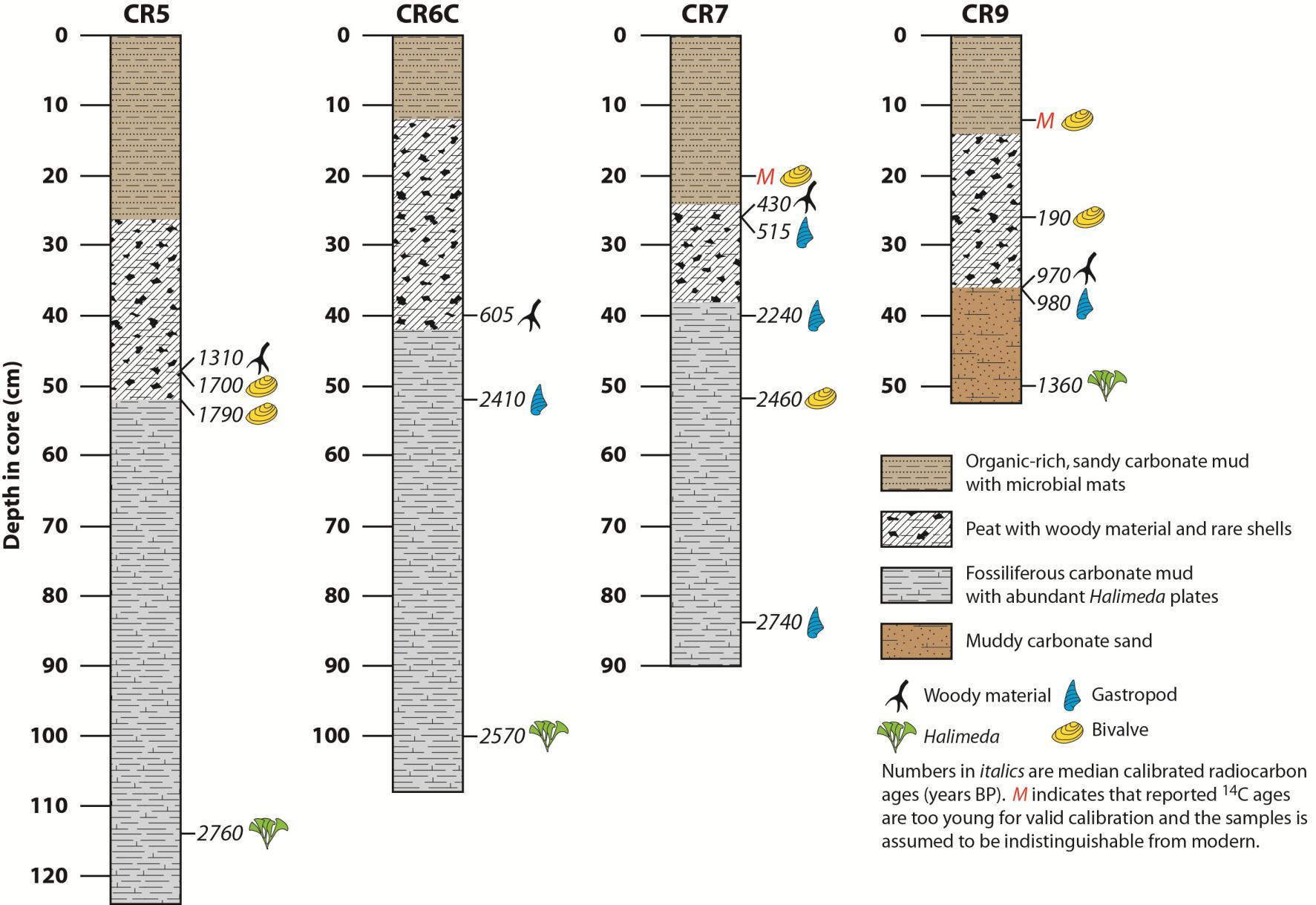
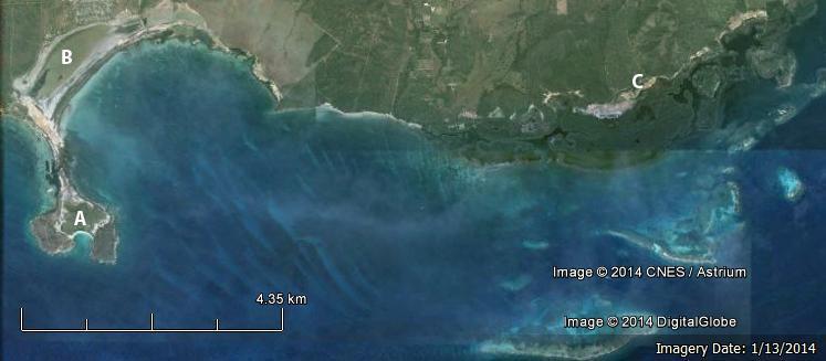
Fig. 6 Southwest Puerto Rico showing locations where cores and emergent carbonate gravels were recovered. A) Southernmost pond; B) Fraternidad Pond; C) Location where emergent carbonate gravels were recovered.
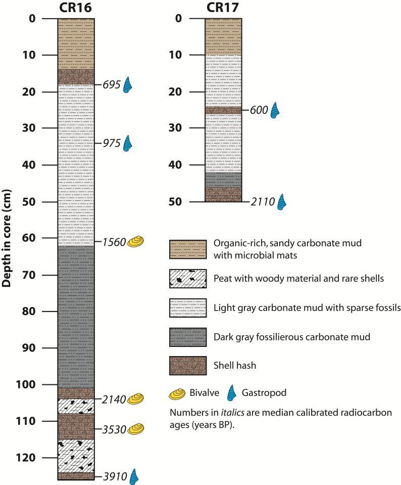
Fig. 7 Stratigraphy and calibrated radiocarbon ages of core material from the Fraternidad pond at Cabo Rojo.
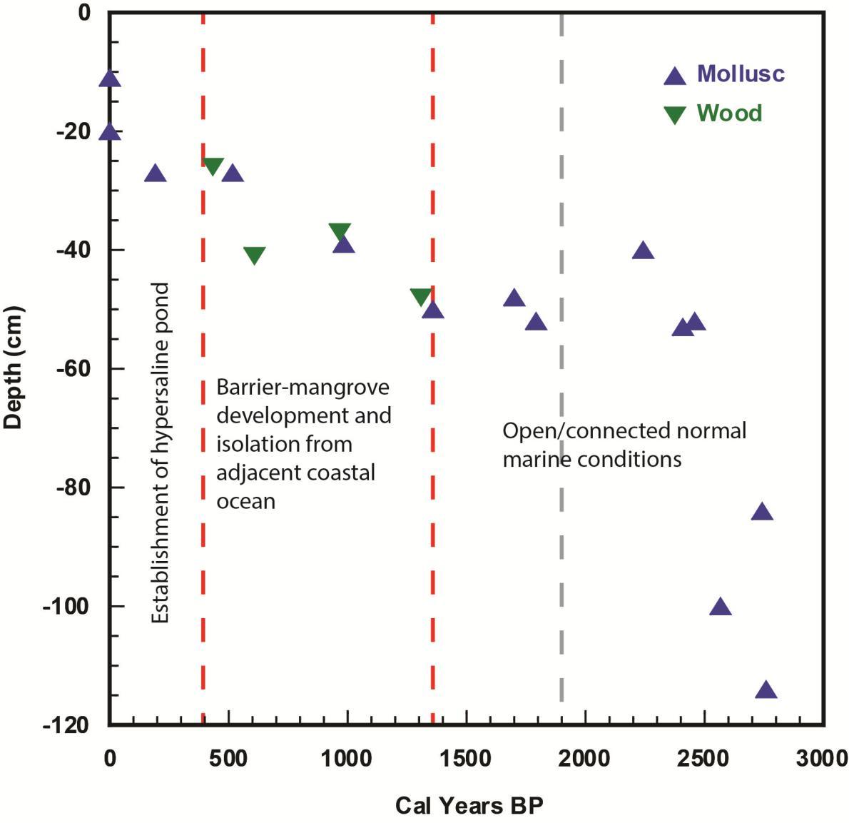
Fig. 8. Calibrated radiocarbon ages versus depth in core of carbonate grains and woody material from the Cabo Rojo cores. Dashed red lines indicate the approximate timing of environmental changes recorded in the cores. Dashed grey line indicates approximate age of emergent carbonate gravels found a t a site ~10 km to the east of the pond (samples PH-C1 and PH-M1; Table 2).
Objectives
Objective 1 – Document the Chronology and Frequency of Marine Flooding Events
The documented stratigraphy reveals a dramatic change along this coastline involving an abrupt transition from normal marine conditions to restricted hypersaline lagoons. Radiometric data indicate that this transition first occurred ~1400-1700 yr BP, with a second transition occurring ~400-500 yr BP. The sharpness of each of these shifts suggests that they may have been event driven. A shell-hash layer dated at ~600 yr BP indicates an overwash event that may have been responsible for the second transition documented in the core stratigraphy. Current salt pond settings are geologically quite young and seem to have been established only ~400 yr BP. Within the salt pond sediments, thin carbonate sand layers in some cores suggest overwash events. However, because they are so recent, their precise age cannot be established by
radiocarbon methods. It appears that there may been 2-3 overwash (marine-flooding) events over the last ~400 yr.
Objective 2 – Document the Physical Character and Composition of Marine Flood Deposits
The character and composition of all primary facies have been documented to determine depositional setting and environmental changes over time as well as differentiate potential washover deposits. Three primary facies have been described, the Halimeda facies, peat facies, and organic-rich mud facies. Potential washover deposits occur as thin (~1 cm) layers of coarser marine grains consisting primarily of mollusk fragments (i.e., shell hash) within the organic-rich muds of Unit I.
Objective 3 – Correlate Marine Flood Records with Historical and Other Geologic Records
The most striking feature of the documented stratigraphy is the abrupt transition from normal marine conditions to mangrove swamp and isolated hypersaline pond. Radiocarbon ages indicate that this transition occurred at ~1400-1700 yr BP and may have been relatively sudden. A reconstruction of hurricane activity based on cores from Laguna Playa Grande, Vieques, PR, identifies a period of intense tropical storm activity occurring between ~2500 to 1000 yr BP, with a particularly large storm occurring ~1500 yr BP. This period of intense hurricane activity coincides with abrupt and significant changes occurring along the coast of southwest Puerto Rico. Additionally, the Vieques record also documents a prominent event occurring at ~500 yr, which roughly corresponds to the second transition noted in the Cabo Rojo record. Thus, timing of environmental changes documented in the salt ponds of southwest Puerto Rico may reflect intervals of intense hurricane activity.
Other geological records of interest for comparison include elevated shoreline deposits near Rincón, PR with ages that range from ~1350-1900 yr BP. Recent tectonic movements have been proposed as an explanation for these deposits. Records from the southern Caribbean suggest the occurrence of three large tsunami events occurring at ~500, 1500 and 3500 yr BP. Interestingly, the timing of the younger two tsunami (i.e., 500 and 1500 yr BP) roughly corresponds to the timing of stratigraphic/environmental changes in our cores from Cabo Rojo.
Impacts and products
This study documents geologically recent and significant changes occurring along the coast of southwest Puerto Rico. Based on comparison with other records, timing of these changes may reflect intervals of increased hurricane activity. Other possible causes could include coseismic displacements or tsunami strikes. The current hypersaline pond environments and geologically young, becoming isolated from the adjacent ocean only ~500 yr BP. Regardless of the cause of the documented changes, this work highlights the dynamic nature of this coast and its acute sensitivity to environmental changes. Future tropical cyclones and projected sea-level rise over the coming century should be expected to have a significant impact on this delicate system
Students
Joel O. Fernández Ramos (MS candidate) Department of Marine Sciences, University of Puerto Rico at Mayagüez
[15]
Email: joel.fernandez@upr.edu
Expected graduation December 2015
This study forms the basis of Mr. Fernández’ thesis.
Total Salary (SG Funds): $37,350; September 2010-May 2013; 20 hrs/week
Presentations
Fernández, J. and Sherman, C., Depositional history and coastal evolution of salt ponds, southwest Puerto Rico. 62nd Annual Meeting of the Southeastern Section of the Geological Society America, San Juan, Puerto Rico, 20-21 March 2013.
A record of late Holocene coastal evolution and relative sea-level change from a coastal salt pond, southwest Puerto Rico. UPR Sea Grant Fifth Applied Research Symposium, Mayagüez, Puerto Rico, 20 February 2014.
Sherman, C. and Fernández, J., A record of late Holocene coastal evolution and relative sea-level change from a coastal salt pond, southwest Puerto Rico. 2014 GSA Annual Meeting, Vancouver, British Columbia, 19–22 October 2014.
Publications
A manuscript is being prepared for submission to the Journal of Coastal Research.
References
Bush, D.M., Webb, R.M.T., Hyman, L., Gonzalez Liboy, J. and Neal, W.J., 1995. Living with the Puerto Rico Shore. Living with the Shore. Duke University Press, 193 pp. Donnelly, J.P., 2005. Evidence of past intense tropical cyclones from backbarrier salt pond sediments: a case study from Isla de Culebrita, Puerto Rico, USA. Journal of Coastal Research, SI(42): 201-210.
Donnelly, J.P. and Woodruff, J.D., 2007. Intense hurricane activity over the past 5,000 years controlled by El Niño and the West African monsoon. Nature, 447(7143): 465-468.
Engel, M., Brückner, H., Wennrich, V., Scheffers, A., Kelletat, D., Vött, A., Schäbitz, F., Daut, G., Willershäuser, T. and May, S.M., 2010. Coastal stratigraphies of eastern Bonaire (Netherlands Antilles): New insights into the palaeo-tsunami history of the southern Caribbean. Sedimentary Geology, 231(1-2): 14.
Lane, C.S., Clark, J.J., Knudsen, A. and McFarlin, J., 2013. Late-Holocene paleoenvironmental history of bioluminescent Laguna Grande, Puerto Rico. Palaeogeography, Palaeoclimatology, Palaeoecology, 369(0): 99-113.
Morton, R.A., Richmond, B.M., Jaffe, B.E. and Gelfenbaum, G., 2006. Reconnaissance investigation of Caribbean extreme wave deposits - preliminary observations, interpretations, and research directions, Open File Report 2006-1293. US Geological Survey, pp. 46.
Scheffers, A., 2004. Tsunami imprints on the Leeward Netherlands Antilles (Aruba, Curaçao, Bonaire) and their relation to other coastal problems. Quaternary International, 120: 163172.
Woodruff, J.D., Donnelly, J.P., Mohrig, D. and Geyer, W.R., 2008. Reconstructing relative flooding intensities responsible for hurricane-induced deposits from Laguna Playa Grande, Vieques, Puerto Rico. Geology, 36(5): 391-394.
[16]