The Murillo Bulletin Journal of
PHIMCOS
The Philippine Map Collectors Society Issue No. 1 February 2016


A Message from the President page 2 News and Events in 2015 3
PHIMCOS Exhibition: The First Philippine Republic & the United States: 1898–1907 7 Shopping for Islands: Behind The Door Bargaining for the Philippines in The Treaty of Paris 9 The Quiet Santa Mesa Hill: The Start of the Philippine-American War 10 Emilio Aguinaldo y Famy: A Great Asian Leader for All Times 11 Socializing with the Tafts 12
PHIMCOS Roving Exhibition 13 Buying the Duke of Northumberland’s Murillo Velarde Map 15 A Blast from the Philippine Past: The Island of Palmas Case 17
PHIMCOS Board Members and Members 2015 19
PHIMCOS Committee Members 2015 and Membership & Enquiries 20
The Philippine Map Collectors Society (PHIMCOS) was initiated in 2007 by a group of five enthusiasts in Manila who conceived the formation of the first club for map collectors in the Philippines. Membership of the Society, which has now grown to a current total of 25 active members, is open to anyone interested in collecting maps, historical prints, paintings, and old photographs of the Philippines. At the Society’s general meetings, held quarterly, members discuss club business, exchange cartographic news, and show each other items of interest. After dinner a member or invited guest (or sometimes both) will give a presentation. The Society also sponsors exhibitions, lectures and other educational events.

IT IS with great pleasure that we start the new year by publishing this inaugural issue of
The Murillo Bulletin, the journal of the Philippine Map Collectors Society (PHIMCOS). Through this journal we hope to share with you, the readers, details on the activities of the Society as well as the wealth of information that we generate through our various events.
Although our Society is relatively young, we have had five successful exhibitions to date featuring European Impressions of the Philippines in the 16th and 17th Centuries; First Impressions: Early Views of the Philippines; Three Hundred Years of Philippine Maps 1598–1898 (covering the period of Spanish colonial rule); the brief British Occupation of Manila and Cavite in 1762-64; and in 2015 The First Philippine Republic & the United States 1898–1907
Well-researched, fully illustrated catalogues were published for the latter three exhibitions to give the attendees and other interested parties not only a useful guide but also a unique memento of the event. All of the maps and images shown during the exhibitions were laboriously gathered from private collections, making it virtually impossible to again view all of the items in one setting.
During the recent exhibitions, lectures were held on carefully selected topics given by well-known experts and scholars. These sessions provided the participants not only valuable information relating to the history and culture of the period covered, but also the opportunity to discuss matters relevant to the topic being presented.
At our quarterly membership meetings, we schedule two or three presentations primarily by members on selected matters of interest to the Society. We continue to be amazed by the breadth and depth of the knowledge and expertise of our members.
Another activity about which we are particularly proud is our Roving Exhibition Program where we organize events in different schools around the country to show their students and faculty copies of selected maps accompanied by important related historical information. The events also often feature a lecture by a well-known expert to provide the students and their professors a historical overview of the subject matter.
I would like to thank the Communications Committee of PHIMCOS and Peter Geldart, the committee chairman and editor of the journal, for the outstanding work done on this first issue of The Murillo Bulletin
We appreciate your interest in our Society’s activities and we welcome your feedback on the matters covered by our journal.
Jaime C. González PresidentTHE Philippine Map Collectors Society (PHIMCOS) was enthusiastically supported in 2015. Membership of the Society continues to grow, and we were very pleased to welcome six newcomers during the year (see page 19). Our four meetings were all very well attended, and we enjoyed a record number of stimulating presentations. 2015 was also the year in which we sponsored another highly successful exhibition.

At our first meeting of the year, held at the Manila Polo Club on March 9, the annual election of new board members and officers was confirmed. Having undertaken the role since he formed the Society, Nito Cacho announced that he was stepping down as President, and Jimmie González was formally welcomed as the new PHIMCOS President. We are delighted that, notwithstanding his busy travel schedule, Nito remains actively involved with PHIMCOS as Chairman Emeritus.
We also welcomed Yvette Montilla as the new PHIMCOS Assistant. Yvette has replaced her sister, Mariros Ripoll, whose tireless contributions as Assistant since the inception of PHIMCOS are remembered with great thanks.
After dinner Rolf Lietz showed the meeting a copy of the “Treaty of Paris Map” published by the U.S. Government as an attachment to the Treaty of Peace between the United States of America and the Kingdom of Spain of 1898. The map, published in 1899, comprises a montage of six seacharts by the U.S. Hydrographic Office that are themselves based on six British Admiralty charts first published between 1856 and 1867 The map is enormous (107.5” x 56.6”) and includes 11 inset charts of important ports, bays and islands.
The Treaty of Paris map (see also page 8) ˃
On April 29 we held the official opening of the PHIMCOSsponsored exhibition The First Philippine Republic & the United States: 1898–1907, which was open to the public until July 9 and was very well attended. In conjunction with the exhibition, PHIMCOS arranged for a series of talks given by eminent academics on related topics; the lectures were popular, and some were attended by over 80 members of the Society, students and members of the public.
An account of the exhibition is given on page 7, followed by summaries of four of the lectures.
The Society’s second meeting of 2015 was held at the Tower Club on May 13, and maiden presentations were given by two members. First, Carlos Madrid spoke on Hidden Treasures in the Maps of Francisco Coello From 1849 to 1852 Francisco Coello de Portugal y Quesada, a Spanish cartographer and lieutenant colonel in the Spanish Army Corps of Engineers, published three maps of the Philippines as part of his monumental Atlas de España y sus posesiones de Ultramar. To quote Carlos Quirino: “Each sheet measured about 30 by 42 inches, and together form the largest map ever published of the archipelago. Its preparation is credited to Antonio Morata and the historical information written on its face to Pascual Madoz.”
Coello’s maps were the finest and most detailed of the Philippines published in the 19th century. Dr. Madrid explained how the accuracy of the topographic and hydrographic information in the maps, especially in the highly-detailed insets of important areas such as the city of Manila, can be shown by comparison with modern satellite imagery.
These comparisons can be used to track changes in topography and climate, and to rediscover monuments and buildings that have since been modified or destroyed. For example, superimposing sections of Coello’s plan of Manila in the 1840s on today’s Google map shows the changes that have occurred over the past 165 years in such districts as Intramuros, Malacañan, the Isla de Convalecencia and Binondo (notably in Jaboneros and Sevilla streets), and to the circular municipal cemetery built by the Dominicans in the 1820s which is now known as Paco Park.
Inset plan of Manila from Francisco Coello’s Islas Filipinas Primera Hoja Central, 1852 (Photograph courtesy of Gallery of Prints)

Hans Sicat then gave a presentation on a map of the East Indies by Nicolas de Fer which he and his wife Gi (both of whom grew up with a strong interest in history and geography) were thrilled to find when on holiday in Maui, Hawaii in the early 1990s
The map, “a charming hand-coloured miniature map of the East Indies, including the Philippines”, was published in Paris in 1702 when France was the dominant European power. Nicolas de Fer was a cartographer, geographer, engraver and prolific publisher, and although “his works focused more on quantity than quality, [and] were more artistic than accurate”, he became the official geographer for both Louis XIV of France and Philip V of Spain.

Nicolas de Fer
Les Isles Philippines, Molucques et de La Sonde, 1702

Our third meeting was also held at the Tower Club, on August 12, 2015, and after dinner Alberto Montilla showed members present a book published in 1933 together with the printing plate for a reduced copy of the Murillo Velarde map included therein This was followed by a talk by Christian Perez and Peter Geldart on The Naming and Mapping of the Batanes Islands, with the subtitle “Mapmakers have a Problem with Batanes”. The presenters explained how the cartographic names, shapes and deemed locations of the islands have changed repeatedly from the 17th century to the present day The presentation is available on the PHIMCOS website and will be published as an expanded article in the next issue of The Murillo Bulletin.
For the last meeting of the year, on November 11, members enjoyed a new venue (the Arya Residences in Bonifacio Global City) and no less than three presentations. The first was The Restoration of a 1788 Murillo Velarde Map by Alberto Montilla and Christian Perez. Mr. Perez explained how he had acquired a very rare map, the small 1788 edition of Murillo Velarde’s Carta Hydrographica y Chorographica delas Yslas Filipinas which had been published in the first volume of the scarce Historia General de Philipinas by Fray Juan de la Concepción.
The map, printed on extremely fragile paper, was torn, folded, glued to acidic blue paper, and covered with flaking brown varnish. Although he did not think it could be restored, Christian bought the map because so few copies of the 1788 state of the Murillo Velarde map have survived.


However, Alberto Montilla suggested that there would be little to lose if restoration of the map was attempted by a team of three restorers mentored by Alberto who now work for the Ortigas Foundation. The process of restoration, which took the team a total of 159 hours over a period of several months, was photographed at each stage, and the audience was able to see how the map was repeatedly washed in pH-balanced water, the varnish painstakingly removed, the backing paper peeled off and replaced with new acid-free Japanese paper, tears repaired and lost paper replaced. At the end of the presentation, the restored map was made available for all to admire.
Velarde map before restoration
Raphael Lotilla then gave a talk entitled A Blast from the Philippine Past: Maps and Territorial Title in which he set out the details of the Island of Palmas Case. As the case involved claims of sovereignty over the island, and was decided against the United States and in favour of the Netherlands (now Indonesia) largely on the grounds of that country’s ability to prove continuous and peaceful state authority over the island, there are lessons to be learned that are relevant to the current territorial disputes in the West Philippine Sea. Of particular note, the arbitrator stated that “a map affords only an indication – and that a very indirect one – involving recognition or abandonment of [sovereign] rights.” A full summary of the case can be read in the article on page 17.
To conclude the meeting, our invited guest Mel Velasco Velarde recounted how he was able to buy, at auction, a previously unknown original copy of the most famous map of the Philippines, the Carta Hydrographica y Chorographica delas Yslas Filipinas, published by Fr. Pedro Murillo Velarde in 1734 Mr. Velarde’s account of his purchase can be read on page 15, and PHIMCOS thanks him for his decision to donate the map to the National Museum of the Philippines as a bequest to the nation.
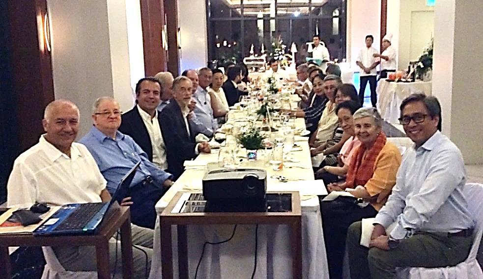
Members and guests at the PHIMCOS meeting of November 11, 2015

IN 2015 PHIMCOS organised the fifth in its series of sponsored exhibitions; The First Philippine Republic & the United States: 1898–1907 featured historical and rare maps, prints, photographs, flags, medals and other memorabilia commemorating the eventful years from the Battle of Manila Bay on May 1, 1898 until the opening of the Philippine Assembly on October 16, 1907 The exhibition, held at the Yuchengco Museum, was open to the public from May 1 to July 9, 2015.

The exhibition was officially opened on April 29, 2015 by U.S. Ambassador H.E. Philip S. Goldberg, Yuchengco Museum Curator Jeannie Javelosa and PHIMCOS board members, in the presence of representatives of the exhibition’s sponsors (notably the Gold Sponsors, Coca-Cola and Fundación Santiago, and the Silver Sponsors, AES Philippines, CBRE Philippines and GE Philippines), PHIMCOS members and their guests.

Vince Perez, Jaime Laya, Philip Goldberg, Jeannie Javelosa & Nito Cacho cut the ribbon
Arranged across three large rooms, the exhibition was divided into sections covering the SpanishAmerican War (from the Battle of Manila Bay on May 1, 1898 to the First Battle of Manila on August 13, 1898); the Philippine-American War, including the role in the Philippine revolution played by General Emilio Aguinaldo, the battles of Caloocan, Cavite and Malolos, and the fighting in Northern & Southern Luzon and in Mindanao; the Philippine Exposition at the St. Louis World Fair of 1904; Governor-General William Howard Taft; and the Philippine Assembly of 1907.
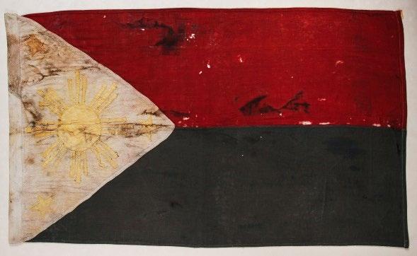
Highlights of the exhibition included a photograph of the U.S. invasion fleet at anchor in Hong Kong; military maps of the Spanish, American and rebel front lines; revolutionary flags; photographs of the generals and other officers, the troops, battlegrounds, casualties and civilians; contemporary illustrated newspapers; souvenirs of the 1904 World Fair; postcards from the visit of William H. Taft in 1905; coins, medals and insignia; and a wide selection of contemporary maps of the Philippines and plans of Manila, notably the enormous “Treaty of Paris” map.
The Battle of Manila Bay painted by F. Fetherstone; copyrighted by M.F. Tobin U.S.V. Navy, New York 1898


The spectacular Treaty of Paris map on display with (from left) Nito Cacho, Manny Ticzon, Peter Geldart, Christian Perez, Vince Perez, Yvette Montilla, Alberto Montilla, Alfredo Roca and J.M. Arcadio Malbarosa

A synopsis of the lecture given by John L. Silva on May 9, 2015
DURING the fall of 1898 the representatives of the United States and Spain met in a mansion on the Quai d’Orsay in Paris to negotiate the treaty that would end the Spanish-American War John Silva described the protagonists, the setting for the talks, the rules of protocol, and the tortuous progress of the negotiations. Throughout October the talks were bogged down; but terms were eventually agreed for the acquisition of Cuba by the United States, and in early November the commissioners (who knew little about the country) turned to the Philippines.
For the Americans, commercial and economic issues were paramount, with the Philippines seen as a stepping-stone to the markets of China. President McKinley was indecisive and “prayed to Almighty God for light and guidance”; one night it came to him that “giving the archipelago back to Spain would be cowardly and dishonorable, … leaving the Filipinos to rule themselves was not feasible for they were unfit for self-government, and … the United States must acquire the islands”.
In the Philippines, General Emilio Aguinaldo announced independence from Spain and tried hard to prove that his revolutionary government was one to contend with. Aguinaldo sent Felipe Agoncillo to the U.S. as ambassador, but McKinley would not allow him to participate in the treaty negotiations. Neither the Filipino nor the Cuban representatives would be allowed to enter the Foreign Ministry in Paris; although the Commission did receive extensive documents from Ambassador Agoncillo, they were to be of no purpose.
After hard bargaining, and with Christmas fast approaching, the Spanish government “by lofty reasons of patriotism and humanity … and in order to avoid all the horrors of war” capitulated to a U.S. ultimatum and agreed to sell Cuba, Puerto Rico, Guam and the Philippines to the United States for US$20 million. The Treaty of Paris was signed on December 10, 1898, but needed to be ratified. In Spain the Queen Regent overrode the Cortes and signed. In the U.S. there was strong opposition from the Anti-Imperialist League, but when war with the First Philippine Republic broke out on February 4, 1899 Congress ratified the treaty by just one vote.
U.S. Secretary of State John Hay signs the Treaty of Paris on December 10, 1898

A synopsis of the lecture given by Dr. Benito Legarda Jr. on May 23, 2015
THE Philippine-American war started on February 4, 1899. Contrary to popular belief, it did not start at San Juan Bridge but, as Dr. Legarda explained, a little distance away from the river. The previous year President Aguinaldo had returned from exile in Hong Kong, and the Filipino revolutionary forces had encircled Manila; but the Americans were in possession of Manila and Cavite. The American military governor, Gen. Elwell Otis, was under explicit instructions to avoid conflict, and he had agreed to Aguinaldo’s occupation of the Spanish blockhouses that ringed the city (called bahay kalapati as they resembled oversized dovecots).

Rules of engagement along the line allowed unarmed men to cross back and forth freely; but the road to Blockhouse 6 passed through American-held territory, and there were armed intrusions by Filipino troops (and also by American troops behind Filipino lines). On the evening of February 4, the war started with an exchange of fire between an American patrol and Filipino troops outside the stone-built Blockhouse 7 in Santa Mesa. The official reports agree that the first shot was fired by the Americans, and do not mention any casualties (notwithstanding later claims that on “the quiet Santa Mesa hill ... a dusky warrior fell in death”).
Rockets went up, firing broke out along the line, and the Filipinos attacked across the Balsa Bridge. Following the impulsive encounters during the night, February 5 became a day of deliberately planned attacks. At Balic-Balic Blockhouse 5 and the little church of San Isidoro were destroyed by field guns; the Filipinos were driven out of Barrio Santol and Blockhouse 6; Blockhouse 4 was taken with no American casualties; and after an attack by infantry supported by artillery Blockhouse 7 fell with 43 Filipinos killed (most of the garrison). The Americans crossed the San Juan River, and by mid-afternoon the Filipino troops abandoned Mandaluyong.
The capture of a blockhouse and a revolutionary flag
The fighting was followed by burning, looting and pillage. In all 14 blockhouses had been captured, and the Filipino hero José Torres Bugallon was killed in battle. Aguinaldo sent the Americans a message that he wished to stop further hostilities, but General Otis replied that: “The fighting having begun, must go on to the grim end.” The English barrister Richard Brinsley Sheridan spoke up for the independence of the Filipinos and against the “fearful slaughter”, but the retort from an American officer was: “The United States wants the Philippines, and we have got to take them!”
DR. QUIASON presented General Emilio Aguinaldo as “a true nationalist and patriot” who lived a multi-faceted life. Born in Cavite on March 22 1869 with a principalia pedigree, in his late twenties Aguinaldo led the Magdalo faction of revolutionaries against Spain. Despite having no formal military training, he had a flair for guerrilla tactics and gained a reputation for bravery, calmness, good organization and caring for his soldiers. The death of his brother in the Battle of Binakayan, his greatest victory, did not diminish Aguinaldo’s resolve to carry the fight to the enemy.
Following the Tejeros Convention, friction arose in the Katipunan between Aguinaldo’s faction and the Magdiwang faction led by Andrés Bonifacio (whom Aguinaldo did not hold in high esteem). The Magdalo faction believed the execution of Bonifacio in May 1897 and assassination of Antonio Luna in June 1899 (in which Aguinaldo’s role is still subject to debate) were necessary sacrifices in order to achieve unity in the fight against “the forces of tyranny”. Following proclamation of the Malolos Constitution, on January 23, 1899 Aguinaldo was inaugurated as President of the First Republic of the Philippines.
Aguinaldo was a softly-spoken teetotaller whose many admirable traits included humility, hard work, tenacity, discipline and dignity. Despite his youth, short stature and relative inexperience he impressed foreigners, notably the British military observer Major George Younghusband and the American journalist Muriel Bailey. As President he strove to demonstrate the capability of Filipinos to govern themselves.
After his “deceitful” capture by U.S. forces in Palanan on March 23, 1901, Aguinaldo took an oath of allegiance to the United States, thereby formally ending the First Republic. But after the war he declared: "I have sworn that as long as life lasts I shall labor until I gain the … independence of the Philippines."
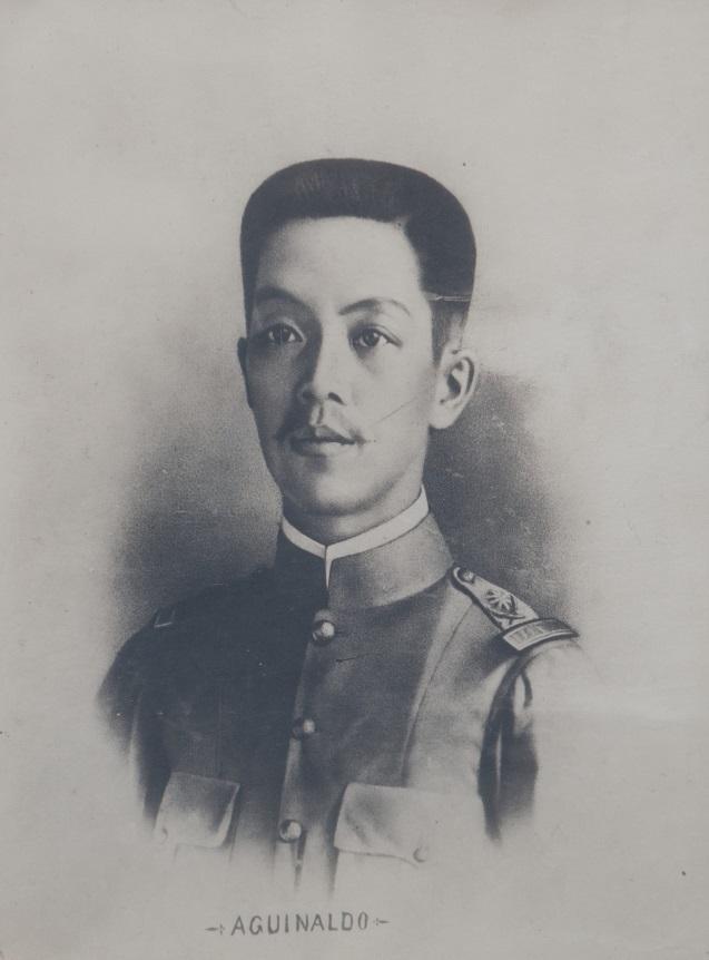
General Emilio AguinaldoAguinaldo continued to be a proud nationalist, and although he was subsequently accused of collaboration with the Japanese during World War II, he was granted a presidential amnesty. A year before he died on February 6, 1964, at the age of 94, Emilio Aguinaldo donated his mansion in Kawit to the Philippine government “to perpetuate the spirit of the Revolution of 1898”.
A synopsis of the lecture given by Martin Imperial Tinio, Jr. on July 9, 2015
WILLIAM HOWARD TAFT was born to a family of distinguished Republicans in Cincinnati, Ohio in 1857; in 1879 he met his future wife, Helen Herron, also from a prominent local political family. Taft was large (6’2” tall and 354 pounds) and athletic, and at 32 he became the youngest U.S. Solicitor General; “Nellie” was ambitious, musical, quite liberated (she smoked, gambled and drank) and, from the age of 17, determined to live in the White House.
Taft arrived in the Philippines on June 3, 1900 as Head of the Philippine Commission, tasked with setting up a civilian government to replace U.S. military rule, and was appointed as the first civilian Governor-General of the Philippines on July 4, 1901. Within two years the Commission enacted legislation to set up a civil service, enforce law and order, build infrastructure, integrate the school system, and establish new municipal and provincial codes.
As the commissioners travelled around the country, Taft identified Baguio as a suitable summer “hill station’, started the construction of Kennon Road, survived an assassination attempt in Batangas City, and made treaties with the local sultans in Mindanao. In 1902 he went to Rome to negotiate the purchase of church lands from Pope Leo XIII, for which the U.S. paid US$7 million.
Helen Taft upset the military establishment by learning local customs and attending Filipino functions, but also set up a nutrition program to safeguard children from deadly epidemics of beriberi. As music-lovers, the Tafts also established the Philippine Constabulary Band, which performed at the St. Louis Exposition of 1904, the presidential inaugural festivities in 1909, and at other occasions in Washington D.C.
In 1904 Taft returned to the U.S. as Secretary of War, but he remained involved with the Philippines and returned in April 1905 on the “Imperial Cruise” accompanied by 7 senators, 23 congressmen, and President Teddy Roosevelt’s eldest daughter Alice In 1906 he was appointed Provisional Governor of Cuba, but he visited Manila again in 1907 for the inauguration of the first Philippine Assembly. In 1908 (with the energetic support of his wife) Taft was elected the 27th President of the United States, but was overwhelmingly defeated in his bid for a second term in 1912. Subsequently he achieved his life-long ambition of becoming Chief Justice of the Supreme Court, until his death in 1930.
William H. Taft and Alice Roosevelt in the Philippines on board the Manchuria, April 1905

IN 2012 PHIMCOS took the initiative to arrange an exhibition that would display reproductions of important maps of Southeast Asia and the Philippines, which could be used to educate the public, schoolchildren and university students unfamiliar with cartography. The captions, in both English and Pilipino, were designed to explain the historical importance of cartography and how the Philippines emerged in maps. The exhibition titled Ang Paglalatag ng Pilipinas sa Mapa – Putting the Philippines on the Map took shape as a series of twelve large panels, with pictures of maps dating from 1525 to 1760, and explanatory text written by Dr. Leovino Ma. Garcia.
The first PHIMCOS Roving Exhibition took place at the Mall of Asia in 2013, and the second at the Intramuros campus of the Lyceum of the Philippines University in Manila in 2014. In 2015 PHIMCOS arranged Roving Exhibitions at five venues, all of which were well-attended and received with enthusiasm by the hosts and their students:

1. SM San Pablo City, Laguna, from 4 to 14 June 2015.
2. Far Eastern University, Manila, from 29 June to 17 July 2015.
3. Department of Foreign Affairs Head Office, Pasay City, from 4 to 14 August 2015.
4. Jose Rizal University, Mandaluyong, from 24 August to 4 September 2015.
5. Beacon Academy, Binan, Laguna, from 21 September to 2 October 2015.
˂ Students examining exhibition panels at Beacon Academy, Binan, Laguna

Marinela Fabella, Manny Ticzon, Maribel Ongpin & Alberto Montilla viewing maps from the collection of the late Armand Fabella at José Rizal University, Mandaluyong ѵ

UNTIL recently, only a dozen or so original copies of the most famous map of the Philippines, the Carta Hydrographica y Chorographica delas Yslas Filipinas drawn by Francisco Suarez, engraved by Nicolás de la Cruz Bagay, and published by the Jesuit Fr. Pedro Murillo Velarde in 1734, were known to have survived. Most of these original copies are in institutional collections in Europe and the United States, with no more than three or four examples held in private hands.
But on November 4, 2014, Sotheby’s in London sold a previously unrecorded copy of this iconic map “by order of the [12th] Duke of Northumberland and the Trustees of the Northumberland Estates”. One of the Duke’s ancestors (possibly Hugh Percy, the 2nd Duke (1742-1817), who was an officer in the British army and later a British peer) may have acquired the map after the occupation of Manila by the British in 1762-64; it remained hidden in the family residence at Alnwick Castle until 2012, when the collapse of a drainage culvert on the Duke’s estates forced him to raise £12 million by selling 80 family heirlooms at auction.

The map is important not only for the size, accuracy, detail and æsthetics of the map itself, but also for the twelve detailed engravings in the two side-panels. Eight of these engravings depict different ethnic groups living in the Philippines, and include two rural scenes with domestic and wild animals including carabao, monkeys and a crocodile The other four engravings are maps of Guajam (Guam), Manila, Samboangan and Cavite.
In his seminal book Philippine Cartography 1320-1899 Carlos Quirino comments: "So important is Pedro Murillo Velarde's map to Philippine cartography, so neat is the engraving and so faithful are the illustrations, that in all likelihood it will continue to be reproduced periodically in the years to come".
Mel Velarde heard about the map for sale from Supreme Court Justice Antonio T. Carpio, who urged him to acquire the map in order to sell it (at cost) to the National Museum of the Philippines. He was particularly taken by the thought that he is a namesake of the author, and decided he should be the buyer of the map.
At Sotheby’s bidding for the map was fierce. Although the pre-sale estimate was only £20,000£30,000, in order to secure ownership of the map Mr. Velarde’s winning bid (including the buyer’s premium} was £170,500 (over ₽12 million) Consequently he has decided not to sell but to donate the map to the National Museum as a bequest to the nation.
(Photographs courtesy of Sotheby’s)
Because it is the first chart to use the name “Panacot” for the reef now better-known as the Scarborough Shoal, the Duke of Northumberland’s Murillo Velarde map has been put on display in The Hague in conjunction with the case filed by the Philippines with the Permanent Court of Arbitration under the United Nations Convention on the Law of the Sea in respect of the dispute with China over artificial reclamation of reefs in the Spratly Islands.
The map is backed with canvas and, as some panels are loose, it requires restoration. Mr. Velarde showed the meeting a full-sized copy of the map which he has had printed on canvas, and his intention is to distribute 49,000 of these copies to all schools in the Philippines, together with a book explaining the historical, cultural and geopolitical significance of the Murillo Velarde map.

 by Raphael P.M. Lotilla
ON APRIL 4, 1928 the Permanent Court of Arbitration sitting in The Hague published its decision in the Island of Palmas Case, a highly influential precedent for island territorial conflicts. The case was “rendered in conformity with the special agreement concluded on January 23, 1925, between the United States of America and the Netherlands relating to the arbitration of differences respecting sovereignty over the Island of Palmas (or Miangas)”. Although the case is important, the island itself is of little economic value; it has a population of no more than 750, and is located some 50 miles southeast of Cape San Augustin in Mindanao and a bit less than 70 miles north of the Nanusa Islands in Indonesia.
The U.S. claim to sovereignty was derived from Spain by way of cession under the Treaty of Paris, and Max Huber, the Swiss arbitrator, found that although the Treaty “comprises the island in dispute within the limits of cession” it had “not created in favour of the U.S. any title of sovereignty such as was not already vested in Spain”. The U.S. argued that Spain acquired sovereignty from (a) discovery of the “Ilha das Palmeiras” by Spanish and Portuguese explorers in the 16th century; (b) the provisions of the Treaties of Münster (1648) and Utrecht (1714) between Spain and the Dutch Republic; and/or (c) the principle of contiguity, i.e. that a small island is part of the territory of the nearest continent or large island.
The arbitrator rejected all three of the U.S. claims on the grounds that (a) discovery can give rise only to an inchoate title, and the U.S. failed to provide evidence that Spain had effectively occupied the island; (b) recognition by treaty did not apply since Spain would have been deprived of any rights she may have held in 1648 by her acquiescence in the possession of the island by the Netherlands after 1677; and (c) title based on contiguity has no standing in international law and, if followed, would lead to arbitrary results.
The Netherlands based its claim to sovereignty on the title of continuous and peaceful display of state authority over the island, and the arbitrator agreed that the evidence showed this to be the case since (a) “Meangis” formed part of two native states which, from 1677, were connected to the Dutch East India Company (and thereby with the Netherlands) by contracts of suzerainty, and (b) effective authority by these powers was shown to have been exercised between 1700-1898, and between 1898-1906.
Consequently the arbitrator ruled against the U.S. and in favour of the Netherlands, and Miangas is now part of the Indonesian province of North Sulawesi (although the adjacent maritime borders with the Philippines are still a subject of disagreement).
One aspect of the Island of Palmas Case which is of particular interest (and potential relevance to other, similar disputes) was the unimportance given to maps as evidence in the case. In his judgement, the arbitrator stated “that only with the greatest caution can account be taken of maps in deciding a question of sovereignty. Any maps which do not precisely indicate the political distributions of territories ... must be rejected forthwith, unless they contribute to the location of geographical names [and] the cartographer has not merely referred to already existing maps ... but that he has based his decision on information carefully collected for the purpose.”
Mr. Huber went on to stress that “the first condition required of maps that are to serve as evidence on points of law is their geographical accuracy”, and points out that “a comparison of the maps submitted ... shows that there is doubt as to the existence or the names of several islands which should be close to Palmas” (notably St. John’s Island). After commenting on specific maps submitted by both parties, he concluded: “Anyhow, a map affords only an indication – and that a very indirect one – and, except where annexed to a legal instrument, has not the value of such an instrument, involving recognition or abandonment of [sovereign] rights.”
The judgement in the Las Palmas/Miangas case afforded the legal community a platform for articulating principles that are the starting point for an evolutionary process. As the technology of mapping has evolved towards ever-greater accuracy, the legal value of maps has evolved as well.
Detail from J.W. Norie’s A New Chart of the China Sea, and East India Archipelago of 1841; Miangas is said to be “Imperfectly known”, and is indeed very imperfectly depicted.

MARIANO CACHO, JR., Chairman Emeritus
JAIME C. GONZÁLEZ, President
JAIME C. LAYA Ph.D., Vice-President EMMANUEL A. TICZON, Secretary VINCENT S. PEREZ, Treasurer RUDOLF J. H. LIETZ, Director PETER GELDART, Director ALFREDO ROCA, Director
Assistant to the PHIMCOS Board: YVETTE MONTILLA
MARGARITA V. BINAMIRA* MARIANO CACHO, JR. MARINELA FABELLA PETER GELDART JAIME C. GONZÁLEZ RICHARD JACKSON
JAIME C. LAYA BENITO LEGARDA RUDOLF J. H. LIETZ RAPHAEL P.M. LOTILLA JOSE L. MABILANGAN* CARLOS MADRID* FRANCISCO ROMERO MILAN* ALBERTO MONTILLA
MARIA ISABEL ONGPIN CHRISTIAN PEREZ VINCENT S. PEREZ MARTHA ISABEL PERIQUET DIETER REICHERT ALFREDO ROCA MATTHEW SUTHERLAND EMMANUEL A. TICZON JONATHAN WATTIS
LEGISPRO CORP. (representatives: Hans B. Sicat* & Regina F. Sicat*)
ORTIGAS FOUNDATION, INC (representatives: Jonathan Best & Beatriz V. Lalana)
* New members who joined in 2015
Communications Committee: Peter Geldart (Chairman)
Francisco Romero Milan Maria Isabel Ongpin Christian Perez
Education Committee: Emmanuel A. Ticzon (Chairman) Margarita Binamira Alberto Montilla Maria Isabel Ongpin
Membership Committee: Carlos Madrid (Chairman) Raphael P.M. Lotilla Hans B. Sicat
PHIMCOS welcomes new members with a keen interest in collecting maps, historical prints, paintings, and old photographs of the Philippines. Prospective members must be nominated by a current member, and will be invited to a general meeting as a guest in order to become acquainted with the officers and other members of the Society.
The initial fee for Individual Membership is ₽6,000, with subsequent dues of ₽6,000 per annum; for Corporate Membership (with 2 nominees) the initial membership fee is ₽10,000, with subsequent dues of ₽10,000 per annum Members and guests who attend general meetings also pay a contribution towards the cost of dinner and drinks of ₽1,000 per person. The membership application form is available for download from our website: www.phimcos.org
For additional information, and enquiries regarding the purchase of PHIMCOS exhibition catalogues, please contact Yvette Montilla at: phimcosinc@gmail.com
Enquiries regarding The Murillo Bulletin, including advertising and letters for publication, may be sent to the Editor at: pcgeldart@gmail.com
Front Cover: A U.S. Army map c1900 (cropped) showing the Department of North Philippines and the Department of South Philippines
Back Cover: Plan of Manila and Suburbs 1899 by George C. Sellner
Printed by Kayumanggi Press, 940 Quezon Avenue, Quezon City, Philippines

