
MOUNTAIN RECREATION CENTRE AND ACCOMMODATION
CONTEXT
1. Location
2. Site
3. Motives
RESEARCH AND ANALYSIS
1. History of the place
2. Degrees of intervention in the natural surroundings and landscape
3. User groups
4. Annual events
5. Current state of existing facilities
6. Comments and opinions
7. The Balkan mountain range. Concept of spatial planning and development
8. Along the route of Botev’s detachment – from Kozloduy to Okolchitsa
9. Pilgrimage route St. Ivan Rilski - from Veliko Tarnovo to Rila Monastery
10. Vrachanski Balkan Nature Park
10.1. Borders, roads, towns and other localities
10.2. Protected nature areas, rocks, caves, mines
10.3. Water resources
10.4. Tourist trails and thematic routes
10.5. Shelters
10.6. Churches and monasteries
10.7. Management plan – zones
10.8. Management plan – urbanized areas
10.9. Management plan – restrictions and recommendations
CONCEPT
1. The locality
1.1. Current state
1.2. Project
2. The Hut Okolchitsa
2.1. Functional structure
2.1.1. Development of the functional model of the hut (hypothesis)
2.1.2. Research on building typologies
2.1.3. Functional groups
2.1.4. Levels of access and ways of functioning
3. Volumes and spatial composition
PROJECT
1. Site
2. Ground floor +-0.00
3. First floor (accommodation type 1) +1.40, +2.70, +3.00, +4.20, +4.45
4. Second floor (accommodation type 2) +4.40, +5.70, +6.00, +7.20, +7.45
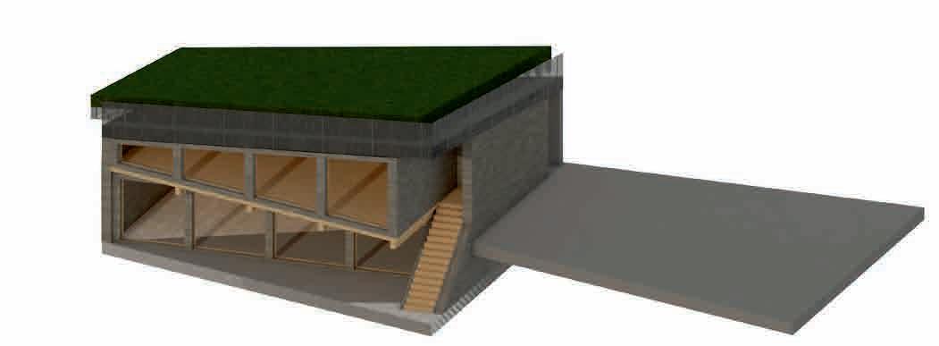
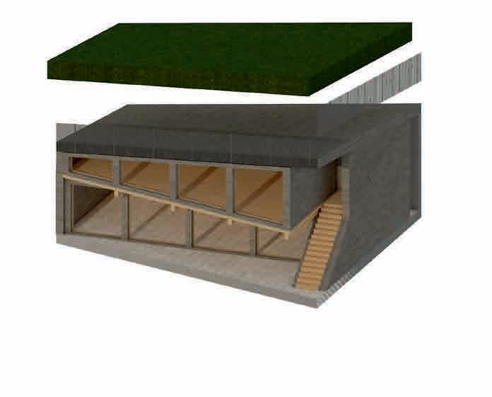
5. Roof
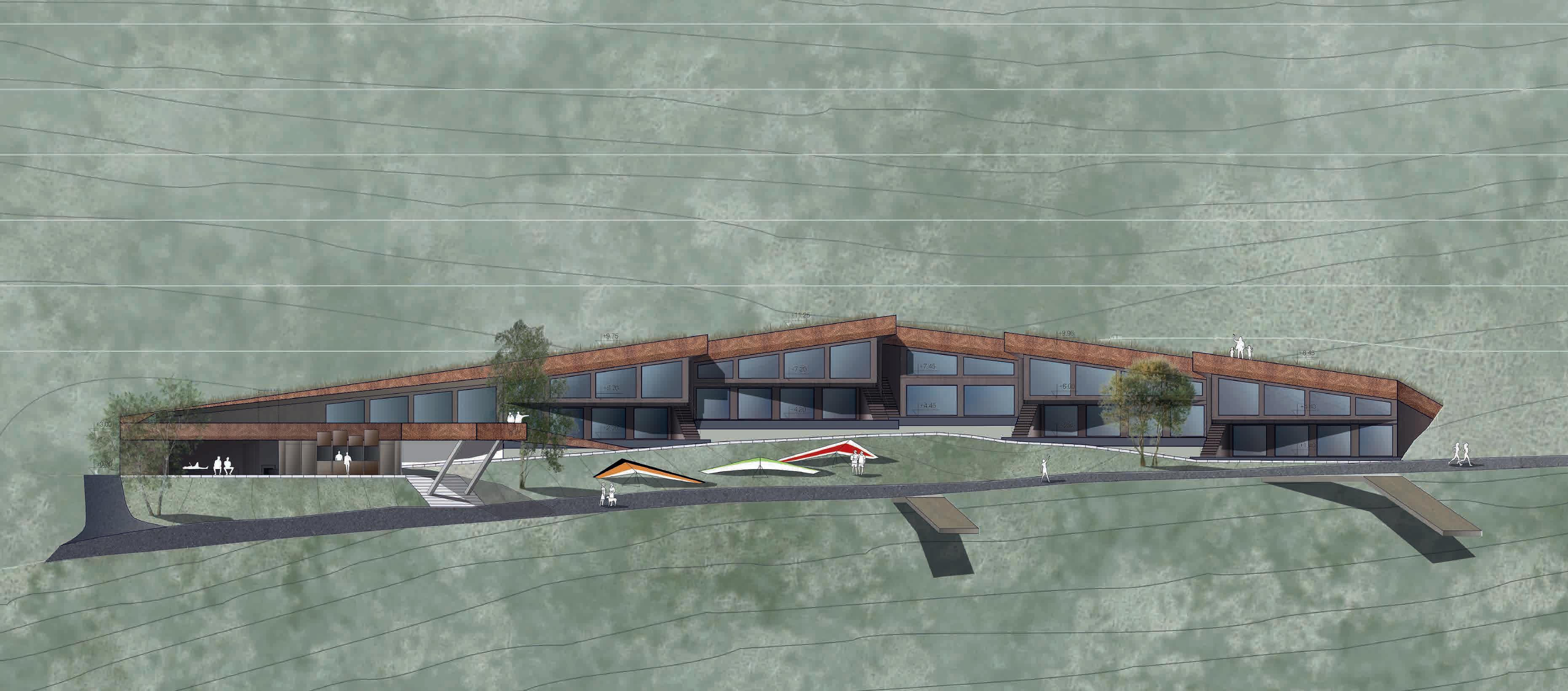
6. East elevation
7. Section A-A
8. Detailed fragment of the accommodation unit
9. Perspective views
10. Sources
CONTEXT
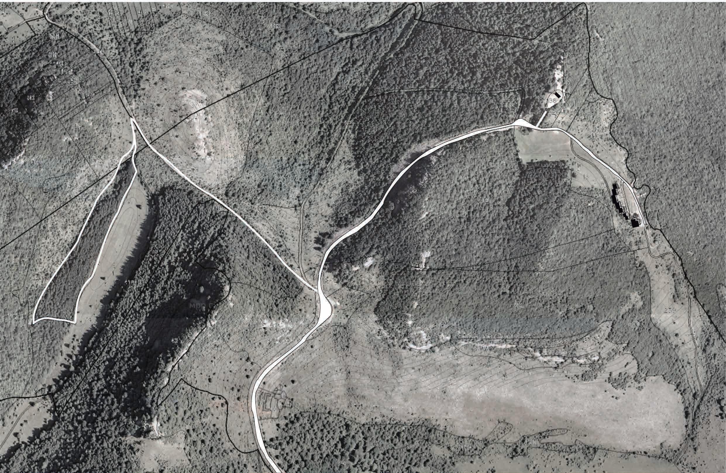
Okolchitsa peak (1048 m) is located in the the Balkan Range, about 20 km from the city of Vratsa, near the village of Chelopek.
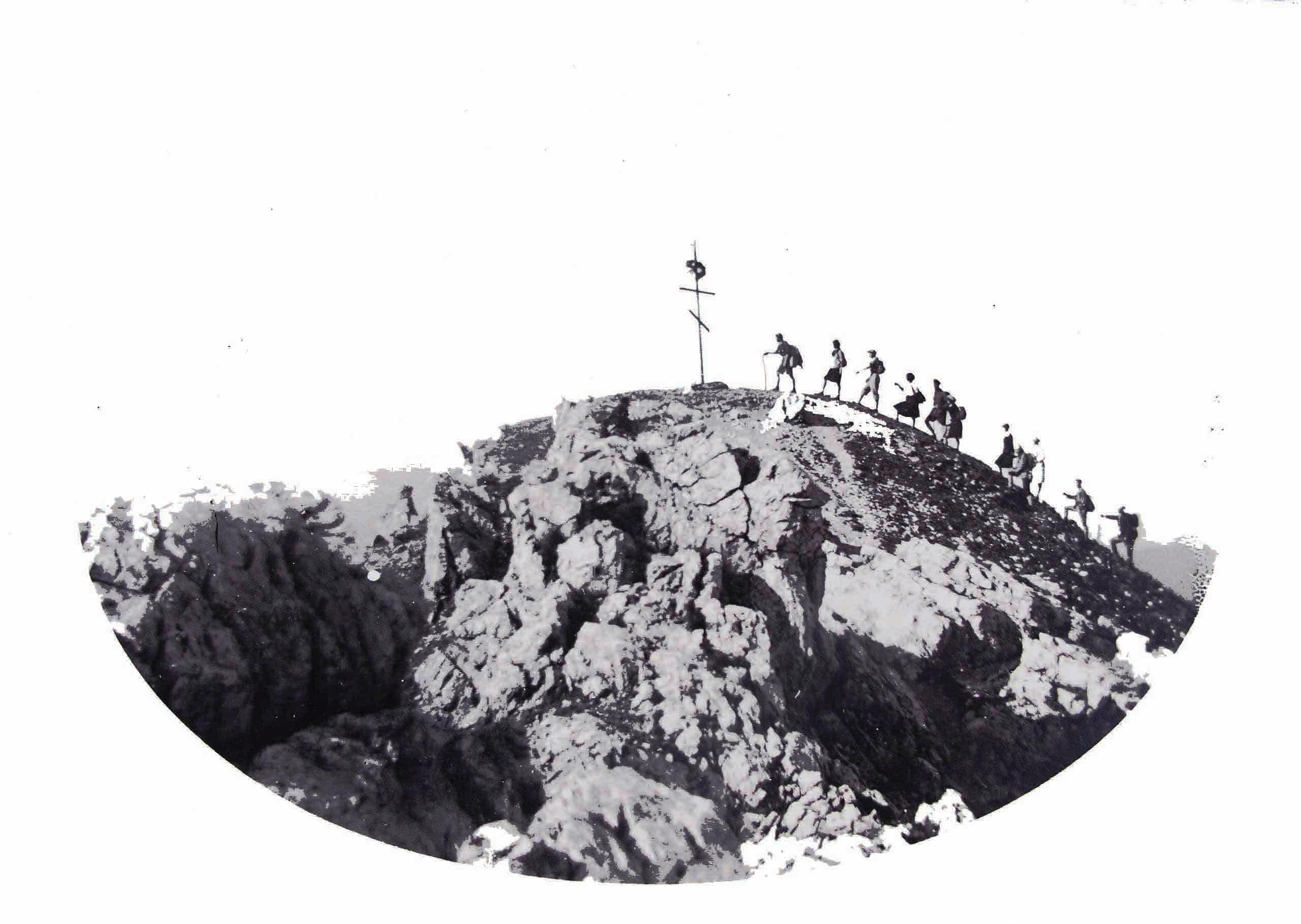
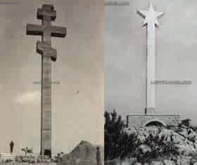
A monument stands at the top, honoring the feat of the poet and revolutionary Hristo Botev and his detachment, who died in 1876 in context of the April Uprising for liberation of Bulgaria from the Ottoman Dominion.
The place was chosen as the most accessible and closest to the place of the last battle of the detachment. There are numerous information signs in the park, describing the historic events of 1876. The actual place of Botev’s death is not far from there, on the Kamarata peak over the Yolkovitsa hollow.
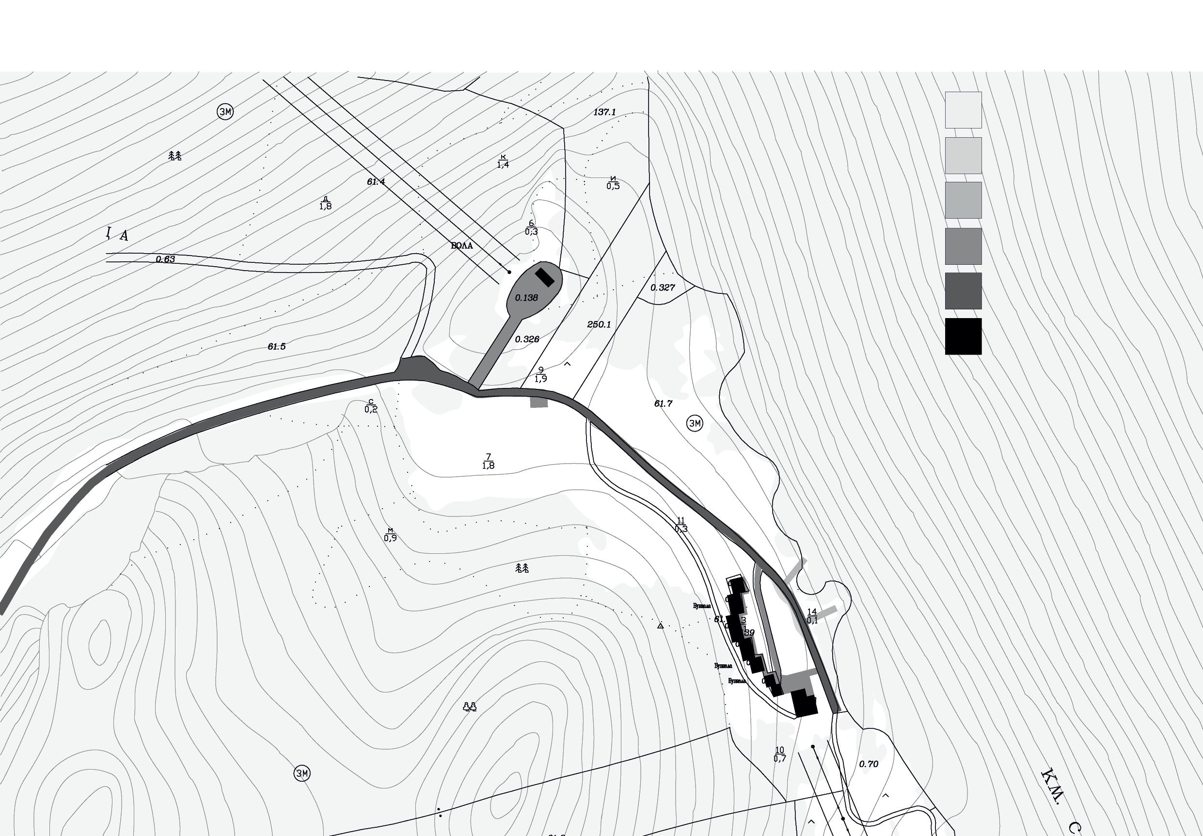
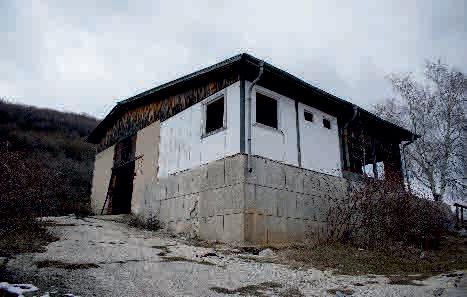
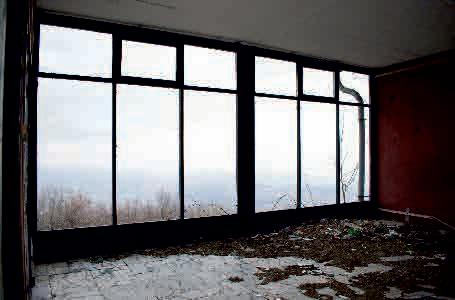
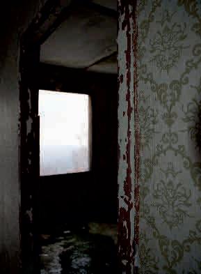
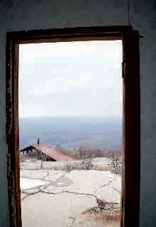
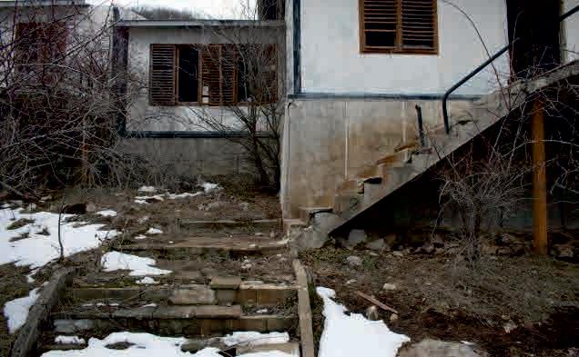
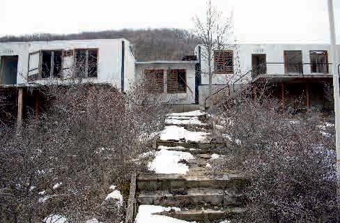
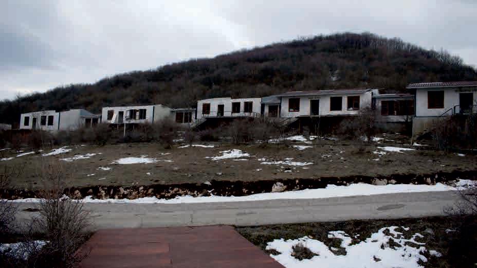
Hut Okolchitsa, about 300 m east from the peak, is a complex of five prefabricated bungalows which once were able to give shelter to 84 guests as total. The whole complex was abandoned. Many of the structures are still standing today, and can be visited despite their poor -condi tion.
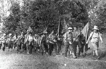
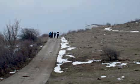
This is the end point of the national hiking expedition along the route of Botev’s detachment. It has taken place every year since 1946. People from across the country – enthusiasts, pupils, students and teachers – cover the 120 km path that Botev took from the Danube town of Kozloduy to the summit of Okolchitsa.
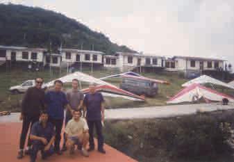
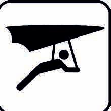
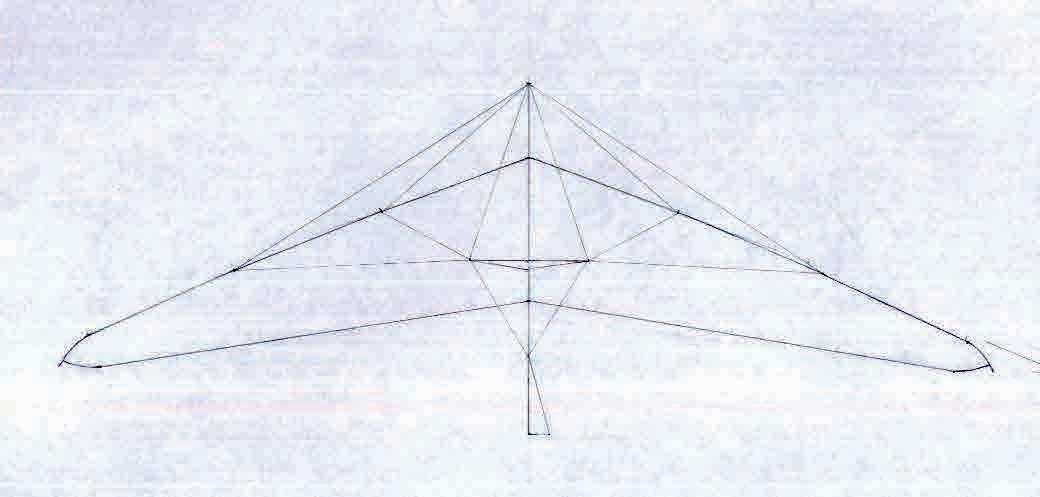
The Okolchitsa peak is a favorite place for hang-gliders from the country and abroad and a preferred place for relaxation during the weekends.
CONTEXT
CONTEXT
CONTEXT 1. LOCATION
Beli izvor
Vratsa
Stoyanovo
Dolno Orizovo
Dolna Bela rechka
Gorna Bela rechka
Gorno Orizovo Lyutadzik
Vratsa
Okolchitsa
Druzhevo
Milanovo
Svrazhen Rakovo
Gara Lakatnik
Opletnya
Ochin dol Eliseyna
Bulgaria
Pavolche Zgorigrad
Chelopek Lyutibrod
Zverino Kostalevo Nefela
CONTEXT 2. SITE
place of Botev’s death
monument
Hut Okolchitsa
CONTEXT 3. MOTIVES
The place is full of life and activities
Research and analyses show that new activities are taking place on the site - rest on weekends, music festivals, practising paragliding and hang gliding. It is recognized by a wide range of users - local communities, pilgrims, tourists and travelers, athletes.
The place is quite problematic and contradictory There is a tangible contradiction between the historical and natural context and the poor condition of the material infrastructure.
The site is part of a larger network part of the national hiking expedition Along the route of Botev’s detachment; part of the pilgrimage route St. Ivan Rilski from Veliko Tarnovo to Rila Monastery; part of a system of urban areas in the territory of the Vrachanski Balkan Nature ParkAs such the site has the potential to activate a whole system of sites
RESEARCH AND ANALYSES
RESEARCH AND ANALISES 1. HISTORY OF THE PLACE
marking the place of Botev’s death and selecting a place for the monument

first official commemoration
raising a cross made of steel raising the monumenta cross made of reinforced concrete
declaration of the route as a cultural heritage
planning and building of the Okolchitsa Hut complex
abandonment and plundering of the Hut - it becomes property of the Local Administration of Vratsa

afforestation of the monument area
first information on hang-gliding and paragliding practice
restoring the original monument restoring the original monument
transformation of the monument into a five-pointed star
the route of Botev’s detachment from Kozloguy to Okolchitsa

first celebration of Vola Open Air Festival
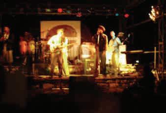
2000 1950 1900 1901 1926 1936 1939 1946 1947 1949 1954 1958 1980 1981 1991 1992 2008 2012
RESEARCH AND ANALISES 2. DEGREES OF INTERVENTION IN THE NATURAL SURROUNDINGS AND LANDSCAPE
natural vegetation and afforestation
beaten tracksidetracks and pahs
temporary structureshang-gliding ramps
pavement asphalt road object
RESEARCH AND ANALISES 3. USER GROUPS


SCIENCE AND EDUCATION

REST AND RECREATION


CULTURE AND HISTORY SPORTS
RESEARCH AND ANALISES 4. ANNUAL EVENTS
1 2 3 7 4 5 6 31 30 29 24 23 22 27 28 26 25 17 16 15 20 21 19 18 10 9 8 13 14 12 11 1 2 3 7 4 5 6 29 24 23 22 27 28 26 25 17 16 15 20 21 19 18 10 9 8 13 14 12 11 JANUARY 1 2 3 7 4 5 6 31 30 29 24 23 22 27 28 26 25 17 16 15 20 21 19 18 10 9 8 13 14 12 11 MARCH 1 2 3 7 4 5 6 30 29 24 23 22 27 28 26 25 17 16 15 20 21 19 18 10 9 8 13 14 12 11 APRIL 1 2 3 7 4 5 6 31 30 29 24 23 22 27 28 26 25 17 16 15 20 21 19 18 10 9 8 13 14 12 11 AUGUST 1 2 3 7 4 5 6 31 30 29 24 23 22 27 28 26 25 17 16 15 20 21 19 18 10 9 8 13 14 12 11 JULY 1 2 3 7 4 5 6 30 29 24 23 22 27 28 26 25 17 16 15 20 21 19 18 10 9 8 13 14 12 11 JUNE 1 2 3 7 4 5 6 31 30 29 24 23 22 27 28 26 25 17 16 15 20 21 19 18 10 9 8 13 14 12 11 MAY 1 2 3 7 4 5 6 30 29 24 23 22 27 28 26 25 17 16 15 20 21 19 18 10 9 8 13 14 12 11 SEPTEMBER 1 2 3 7 4 5 6 31 30 29 24 23 22 27 28 26 25 17 16 15 20 21 19 18 10 9 8 13 14 12 11 OCTOBER 1 2 3 7 4 5 6 30 29 24 23 22 27 28 26 25 17 16 15 20 21 19 18 10 9 8 13 14 12 11 NOVEMBER 1 2 3 7 4 5 6 31 30 29 24 23 22 27 28 26 25 17 16 15 20 21 19 18 10 9 8 13 14 12 11 DECEMBER FEBRUARY period
(birds)
of nesting
pilgrimage route St. Ivan Rilski from Veliko Tarnovo to Rila Monastery national hiking expedition along the route of Botev’s detachment hang-gliding and paragliding season Vola Open Air Festival


570 sq m
TE OF EXISTING FACILITIES
6. COMMENTS AND OPINIONS
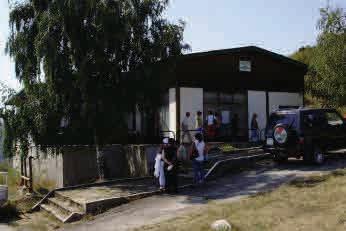
Since 2005 the Hut is property of the Local Administration of Vratsa. Thefts have en place before, but in 2012, the vandals completely destroyed it. "The doors were broken, the windows and all of the installations, the beds were all taken, most of the roof structures are demolished, the view is very unpleasant at the moment" explained the chief expert at the Local Administration Sylvia Pelova.
Dozens of foreigners practising hang gliding and paragliding are also disappointed, because they have nowhere to stay. The biggest shame is on the local community of the nearest village Chelopek, because some of the thieves are local.
Young people were coming back from Okolchitsa, I stopped them and I asked them to tell me what they saw at Vola –“It’s all ruined" said Pavel Grigorov of Chelopek village.
The case against the five perpetrators is scheduled for December 17 in the District Court, the damage is estimated at BGN 2,000, but the restoration of the complex will cost tens of thousands. One option is to apply for finance with a project, the other is to rent it out. An urgent solution is needed in order to stop the devastation of one of the hundred national tourist sites.
source: BTV News
Cornelia Popova attended one of the summer school camps when she was in third ade. "We stayed at comfortable rooms with luxury beds that many people couldn't afford in their own homes, toilets, baths, there was a great restaurant."
Now everything is destroyed.
“There aren’t a lot of places in the world where you have a decent accommodation and a restaurant in close proximity to the take off area (hang gliding ramps), it's just like a eam. It’s a pitty to see it in that horrible state, it can become a wonderful center for hang gliding and paragliding” says Nikolay Yotov, an instructor.
Hang glider pilots from Russia wanted to stay for the night on top of Okolchitsa and they were disappointed, realizing they couldn't."The complex is nice, unfortunately it doesn’t work. We would be happy next time to find a beautiful and comfortable place to stay. ” shared Valery Arhipov.
source: BTV News
RESEARCH AND ANALISES 7. THE BALKAN MOUNTAIN RANGE.
CONCEPT OF SPATIAL PLANNING AND DEVELOPMENT
MODELS OF LAND USE BASED ON THE SPECIFIC CHARACTER OF A MOUNTAIN RANGE
STRUCTURE AND COMPOSITION OF THE BALKAN MOUNTAIN RANGE
transversal - parallel model radial model nerwork model
Western Balkan Mountains
Central Balkan Mountains
conclusions:
- Transversal crossing of mountain ranges can cause significant damage to the mountain balance
-The settlements are formed on the periphery, leaving large modules of free untouched areas between them
Central Balkan mountainstransversal - parallel model
Osogovo
Vitosha
Sredna gora Rila
Balkan mountain rangetransversal - parallel model
-The great length of the Balkan mountain range demands crossings at a certain distance, in order to connect North and South Bulgaria / passes of general and national importance /. These crossings should not be very frequent (it can cause significant damage to the mountain balance), leaving large modules of free untouched areas between them (15/20/30 - 40 km)
AREA A nature area under protectionnature reserve and protected natural sites AREA B modules of free non-urbanised areasagricultural and forest area, rest and recreation areas AREA C - tourist sitestowns and localities
Pirin
Rila-Rhodope massifnerwork model
source: Mountain resorts, Petko Evrev, 1987
BULGARIA - MOUNTAIN PASSES
mountain passes:
1. Petrohan
2. Vladaya
3. Klisura
4. Troyan Karnare
5. Rozhen
6. Shipka
7. Pass of the Republic
8. Kotel
9. Dyulinski
10. Rish
11. Aytos
13. Pomoriyski
15. Tvardishki
16. Vratnik
17. Vitinya
road sections:
12. Karnobat Vetren
14. Kaspichan Varna
main road sections bypasses
source: Road Insfrastructure Agency
VRACHANSKI BALKAN NATURE PARK
conclusions:
- Similar principles(above - mentioned) could be found at a micro level. Within the Vrachanski Balkan Nature Park, such zoning is observed. The site of Okolchitsa falls into the peripheral urbanized territories, suitable for the development of recreation and tourism, without endangering the integrity and balance of the existing structures.
Okolchitsa
RESEARCH AND ANALISES 8. ALONG THE ROUTE OF BOTEV’S DETACHMENT -
RESEARCH AND ANALISES 9. PILIGRIMAGE ROUTE ST. IVAN RILSKI -
FROM KOZLODUY TO OKOLCHITSA FROM VELIKO TARNOVO TO RILA MONASTERY
Okolchitsa
Kozloduy
Rila monastery
Veliko Tarnovo
RESEARCH AND ANALISES 10. VRACHANSKI BALKAN NATURE PARK
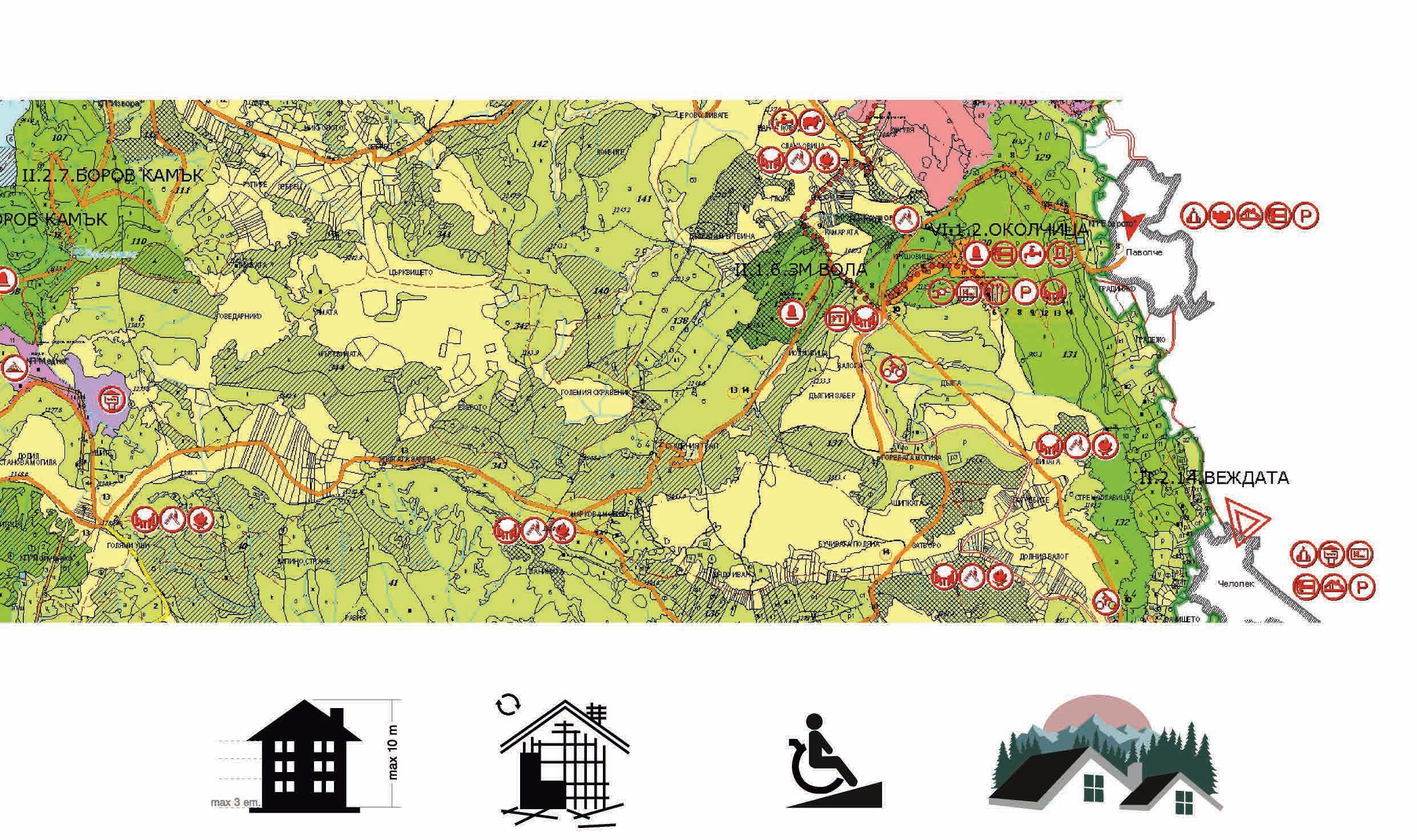
10.1. BORDERS, ROADS, TOWNS AND OTHER LOCALITIES
Beli izvor
Stoyanovo
Dolno Orizovo
Gorno Orizovo
Nefela
Kostalevo
Vratsa
Dolna Bela rechka
Lyutadzik
Gorna Bela rechka
Zgorigrad
Druzhevo
Milanovo
Rakovo
Svrazhen
Gara Lakatnik
Opletnya
Okolchitsa
Pavolche
Ochin dol Eliseyna
Zverino
Chelopek
Lyutibrod
RESEARCH AND ANALISES 10. VRACHANSKI BALKAN NATURE PARK
10.2. PROTECTED NATURE AREAS, ROCKS, CAVES, MINES
Beli izvor
Stoyanovo
Dolno Orizovo
Gorno Orizovo
Nefela
Kostalevo
Vratsa
Dolna Bela rechka
Lyutadzik
Gorna Bela rechka
Borov kamak Protected Area
Druzhevo
Milanovo
Rakovo
Svrazhen
Gara Lakatnik
Opletnya
Ochin dol Eliseyna
Vratsa Karst Nature Reserve
Zgorigrad
Okolchitsa
Pavolche
Chelopek
Vezhdata Protected Area reserves and protected areas rocks caves mines
Zverino
Lyutibrod
Karst zones:
G - Gladna
LE - Ludoto ezero
B - Bistrets
Mt - Matnitsa
S - Stoyanovo
BI - Beli izvor
Z - Zgorigrad
P - Pavolche
Chsh - Cherepish
Md - Medna
Chr - Cherna
BR - Byala Rechka
springs:
1. Ludiyat bigor
2. Gal.680
3. Tsonovoto
4. Ludoto ezero
5. Bistrets
6. Chigoril
7. Spring St. Ivan Rilski monastery
8. Spring of the Residencе
9. Beli izvor
10. Spring St. Ivan Pusti monastery
11. Bigora
12. Vayevete
13. Ezeroto
14. Krushovitsa
15. Spring Cherepish station
16. Lyutibrod
17. Medna
18. Dudil
19. Cherniyat izvor
20. Rakyov kladenets
21. Spring The house
22. Spring Gorna Bela rechka
23. Zhitolyub
24. Petar
Gornoyursko - dolnokreden karst aquifer
Triarski karst aquifer border between karst basins border between karst zones
Zgorigrad Chelopek Bigoro
CHANSKI BALKAN NATURE PARK Vratsa Pavolche
Borov kamak Shopkata
Zhenskata voda
Lyutibrod Zverino Chsh Md G LE P
Nefela Beli izvor Ochin dol Eliseyna
- Cherepishki basin
Medkovsko ripalo Skaklya
Kostalevo
Pavolche
CHANSKI BALKAN NATURE PARK
TOURIST TRAILS
Vratsa eco trail “Borov kamak” – 3 h
Vratsa – Locumcheto locality – Zambina mogila locality – Patshevitsa hut – 4 h
Vratsa – Skaklya waterfall – Patleyna locality –Izbata locality – Peak Okolchitsa – 3 h
Vratsa – Medkovets quarter– Jenskata locality – Peak Okolchitsa – 3 h
Botev’s route: Vratsa – Yolkovitsa locality – Peak Okolchitsa – 3 h
Peak Okolchitsa – Pogledets locality – Rashov dol locality – Lutibrod village – 3 h
Parshevitsa hut – Borov kamak locality – Tsarevo livage locality – Peak Okolchitsa – 4,5 h
Ochin dol village – Parshevitsa hut – 4 h
Lakatnik railway station – Milanovo village – Parshevitsa hut – 5 h
Zverino village – Peak Yavorets – Peak Okolchitsa – 4 h
THEMATIC ROUTES
Historical trail In the footsteps of Botev– 1 h
Historical trail Ancient and medieval Vratsa – 1 h
Thematic rail Vratsa – Cave Ledenika – 3 h
Thematic trail Karst and biodiversity– 1,5 h
Thematic trail Mountaineering for beginners – 2 h
Thematic trail Cave Ledenika – Gorno Orizovo village – 5 h
Thematic trail Griffon vulture In Vrachanski Balkan National Park – 2 h
Thematic trail Griffon vulture In Vrachanski Balkan National Park – 2 hours
Sport-tourist trail “Forest trail of health” – 50 min
Tourist and bike trail Svrazhen – Staro selo – 1,5 h
Thematic trail „Voyvodin dol – Skaklya waterfall“ – 4 h
Thematic trail Eco trail “Belite skali” (The white rocks) – 1 h
Thematic trail “Forest world” – 1 h
Location for camping and picnic - Career locality - near Zgorigrad
Okolchitsa Pavolche Zgorigrad Chelopek Lyutibrod Zverino Kostalevo Nefela Beli izvor Ochin dol Eliseyna 1 10 10 13 1 2 2 3 3 7 4 4 5 6 1 2 3 4 5 6 7 8 9 10
Vratsa
1 2 3 4 5 6 7 8 9 10 11 12 13
RESEARCH AND ANALISES 10. VRACHANSKI BALKAN NATURE PARK
10.5. SHELTERS
Vratsa Okolchitsa Pavolche Chelopek Lyutibrod Zverino Kostalevo Nefela Beli izvor Stoyanovo Dolno Orizovo Gorno Orizovo Lyutadzik Gorna Bela rechka Dolna Bela rechka Druzhevo Milanovo Gara Lakatnik Svrazhen Rakovo Opletnya Ochin dol Eliseyna hut shelter holet / lodge / guest house cabins tent camping caravan camping Hut Parshevitsa Hut Ledenika Forest home Vrachanski Balkan Complex Ledenika AETS Kozloduy EAD Hotel Momina salza Hotel Kiparis Hotel Chayka Camping Karierata Shelter Vratsata The alpinist’s home Shelter Borov kamak Shelter Ochin dol Zgorigrad
RESEARCH AND ANALISES 10. VRACHANSKI BALKAN NATURE PARK
10.6. CHURCHES AND MONASTERIES
Beli izvor
Stoyanovo
Dolno Orizovo
Gorno Orizovo
Nefela
Kostalevo
Vratsa
Dolna Bela rechka
Lyutadzik
Gorna Bela rechka
Zgorigrad
Druzhevo
Milanovo
Opletnya
Okolchitsa
Pavolche
Ochin dol
Rakovo
Svrazhen
Zverino
Chelopek
Lyutibrod
Gara LakatnikEliseyna church monastery
RESEARCH AND ANALISES 10. VRACHANSKI BALKAN NATURE PARK
10.7. MANAGEMENT PLAN - ZONES
Druzhevo
ZONES - zone with a status of natural
I. Nature reserve
II. Protection of biodiversity, landscapes and cultural heritage -zone with a status of natural sites and protected areas -zone of major importance for wild flora and fauna
III. Water catchment areas -protection buffer areas around water catchment facilities
IV Technical and biological recultivation
-damages areas by the mining industry
V. Tourism
VI. Buildings and facilities (urbanized areas for recreation and tourism)
VI. Buildings and facilities (urbanized
VII. Sustainable use of renewable resources
-forest areas
VIII. Recommended alterations in the
-agricultural areas
VIII. Recommended alterations in the limits of the park
Vratsa OkolchitsaPavolche Zgorigrad
Chelopek Lyutibrod Zverino Kostalevo
Nefela
Beli izvor Stoyanovo
Dolno Orizovo Gorno Orizovo Lyutadzik
Gorna Bela rechka
Dolna Bela rechka
Milanovo
Gara Lakatnik
Svrazhen
Rakovo
Opletnya Ochin dol Eliseyna
RESEARCH AND ANALISES 10. VRACHANSKI BALKAN NATURE PARK
10.8. MANAGEMENT PLAN - URBANIZED

AREAS
URBANIZED AREAS FOR RECREATION AND TOURISM - 305,3 HA (1,06% OF THE PARK)
Vratsa Okolchitsa Pavolche Zgorigrad Chelopek Lyutibrod Zverino Kostalevo Nefela
izvor Stoyanovo
Orizovo
Orizovo Lyutadzik Gorna Bela rechka
Bela rechka Druzhevo Milanovo Gara Lakatnik Svrazhen Rakovo Opletnya Ochin dol Eliseyna
Beli
Dolno
Gorno
Dolna
planned new bulidings visitors’ centre Service and administrative centre Service and administ ative cent e Scientific and educational complex - Vrachanski Balkan National park Demont ative centre of dairy farm Parshevitsa VI.1.4. “Parshevitsa” 8,5 ha VI.1.2. “Okolchitsa” 13,8 ha VI.1.5. “Chayka” The alpine home19,8 ha VI.1.5. “Ledenika” 86,7 ha “Ledenika” 86,7 ha “Okolchitsa” 13,8 ha Parshevitsa” 8,5 ha “Chayka” The Alpine home 8,5 ha “Hashove” 2 ha Technomarket 8,5 ha VI.1.3.
locality
locality “Zambina mogila”, locality “Forest home”, locality Tsarkvitse” - 166,0 ha locality “Teachers’ colonies”, locality “Zambina mogila”, locality “Fo est home”, locality Tsarkvitse” 166,0 ha
Vrachanski Balkan”
Teachers’ colonies”,
RESEARCH AND ANALISES 10. VRACHANSKI BALKAN NATURE PARK 10.9. MANAGEMENT PLAN - RESTRICTIONS AND RECOMMENDATIONS
the natural environment and the legislation in
1. New building structures – low-rise buildings up to 3 floors and up to 10 m height (according to Territorial Development Act)
2. Replacement of semi-massive buildings and all kind of structures in a bad state for the needs of recreation and tourism with appropriate sustainable structures;
3. Adaptation of existing infrastructure and buildings for the use of disabled people;
4. The architecture of the reconstructed and /or new buildings, as well as the treatment of their surroundings, should take into consideration
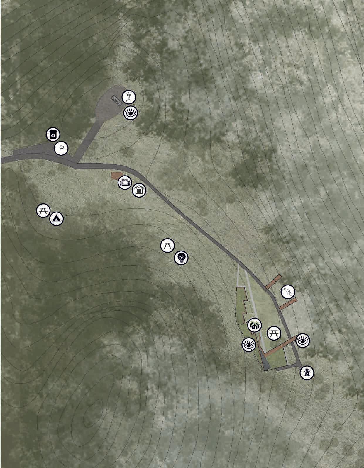
1 2 3 4 5 6
parking area
monument Okolchitsa
outdoor stage
7
8
tent camping training camp - hang gliding and paragliding take-off area - hang gliding and paragliding Hut Okolchitsa service and technical infrastructure area in use (currently) not in use (currently)
6
7
8
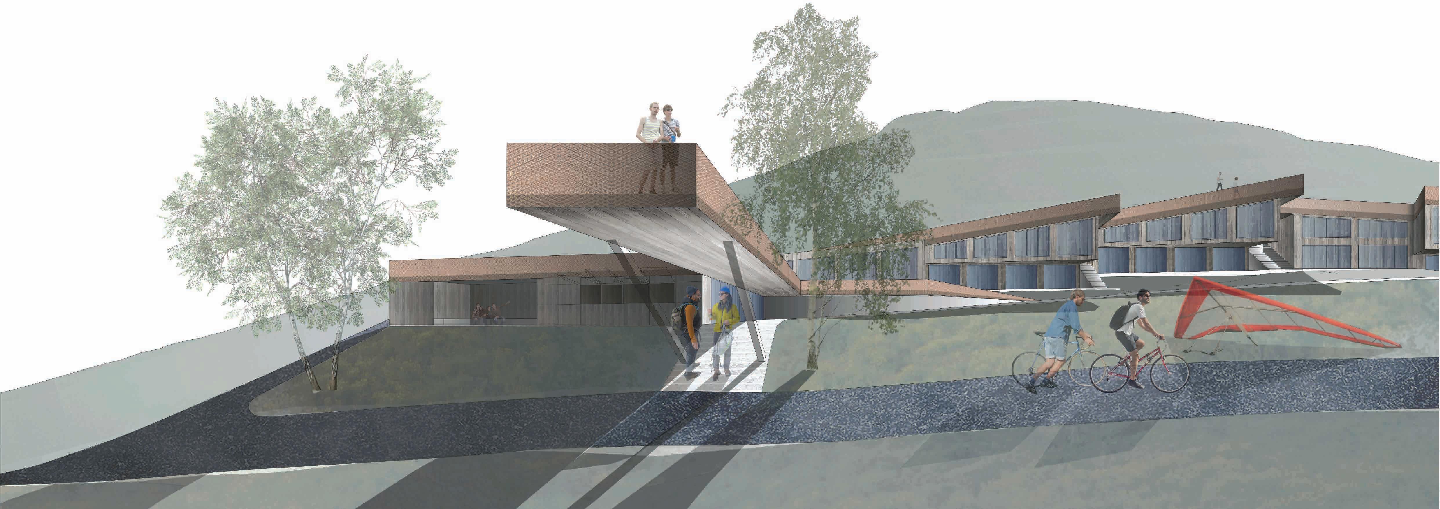
CONCEPT 1. THE LOCALITY 1.2. PROJECT
ЗА ФУНКЦИОНА ЛНО ЗОНИРАНЕ НА ЗОНАТА
зона паркинг
зона „паметник Околчица“
зона сцена на открито
зона палатки
учебна зона за делта- и парапланеризъм
зона излитане делта- и парапланеризъм
зона „хижа Околчица“
зона техническа инфраструктура
1 2 3 4 5 6 7 8
1 2 3 4 5 6 7 8 ПРЕДЛОЖЕНИЕ
P
1 1
2
3
4
5 6 6
7
8
АКТ УА ЛНО С ЪСТОЯНИЕ НА ЗОНАТА
2
3
4
5
7
8
monument
Okolchitsa
parking area
outdoor
stage tent camping training area - hang gliding and paragliding take-off area - hang gliding and paragliding Hut Okolchitsa service and technical infrastructure area
2.1.1. DEVELOPMENT OF THE FUNCTIONAL MODEL OF THE HUT
How it used to work? (hypothesis) closed model
What appears lately? process of self-organisation
What’s next? in search of a new working model
monofunctional model
зона паркинг
„паметник Околчица“
зона палатки
учебна зона за делта- и парапланеризъм
излитане делта- и парапланеризъм
„хижа Околчица“
техническа инфраструктура
складиране на оборудване
площадки
зона паметник
polyfunctional model
CONCEPT 2. THE HUT OKOLCHITSA
2.1. FUNCTIONAL STRUCTURE
зона къмпинг зона делта- и парапланеризъм зона излитане паркиранг учебна зона място за сцена на открито кътове за отдих и почивка зона зрители зона събиране на отпадъци зона база за отдих и почивка „Околчица“ зона техническа инфраструктура изгледни
P
зона
зона
зона сцена на открито 1 2 3 4 5 6 7 8
зона
зона
CONCEPT 2. THE HUT OKOLCHITSA 2.1. FUNTIONAL STRUCTURE
2.1.2. RESEARCH ON BUILDING TYPOLOGIES, BULGARIA
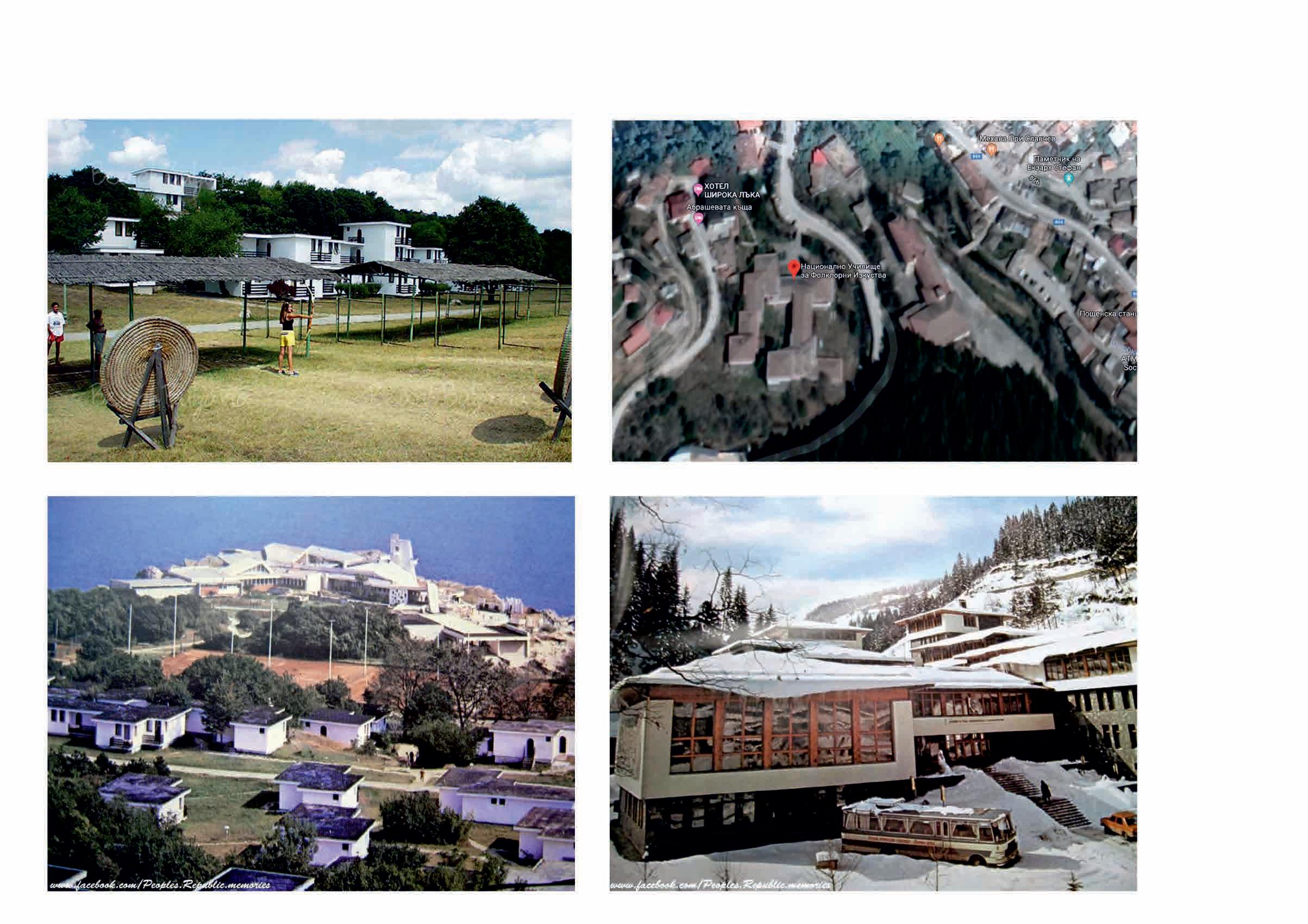
Holiday village “Rusalka”, 1980
Music school, Shiroka Laka
CONCEPT 2. THE HUT OKOLCHITSA 2.1. FUNCTINAL STRUCTURE
2.1.2. RESEARCH OF BUILDING TYPOLOGIES, SPAIN
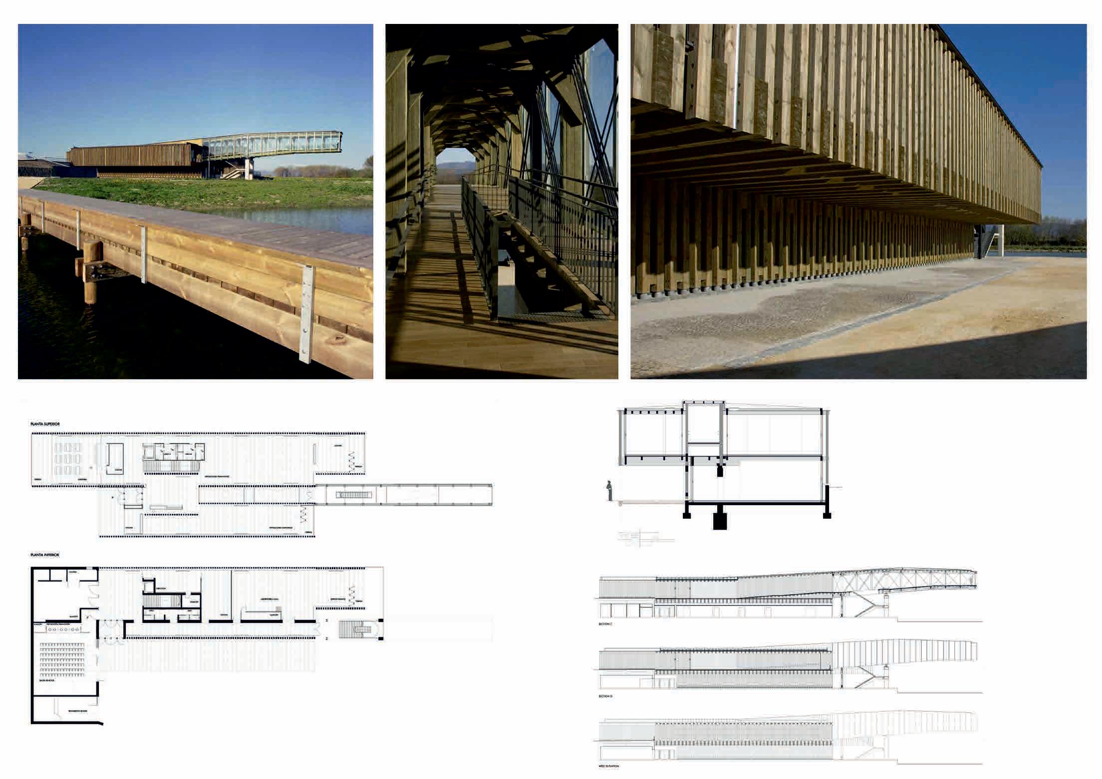
 Salburua Nature Interpretation Centre / QVE Arquitectos, Basque
CONCEPT 2. THE HUT OKOLCHITSA 2.1. FUNCTIONAL STRUCTURE
2.1.2. RESEARCH ON BUILDING TYPOLOGIES, NEW ZEALAND

The Routeburn Track, New Zealand
dining room + kitchen, eation areas
TION


SHARED AREAS
spaces for events, projections, exhibitions, co-working spaces, library
SPECIFIC INFRASTRUCTURE
ramps for hang gliding and paragliding - 3 pcs.
stage structure viewpoint
CONCEPT 2. THE HUT OKOLCHITSA
2.1.4. LEVELS OF ACCESS AND WAYS OF FUNCTIONING
SHELTER seatings outdoor fireplace medicine chest water toilet
VIEWPOINT (observation deck)
GREEN ROOF (viewpoint tribune)
CELEBRATIONS AND FESTIVALS
PAVILION
(option to rent it as a cafe or еquipment shop)
STORAGE
(mobile stages, chairs, music equipment, sport equipment)
ACCOMMODATION
(sleeping unit type 1 sleeping unit type 2)
*maintenance staff before and after accommodation is needed
GROUP VISITS
KITCHEN AND DINING ROOM
(in case of food delivery, staff is needed visitors can use the kitchen themselves without service staff)
MULTIFUNCTIONAL HALL
1 1 2 2 3 3 4 4 5 5 6 6 6 7 7 8 8
groups of hang gliding and paragliding pilots
seminars and team buildings for companies and non-governmental organizations green schools
friends and families
24/7
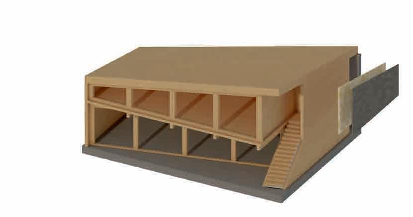
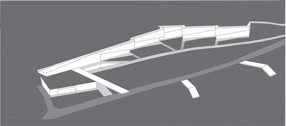
CONCEPT 2. THE HUT OKOLCHITSA 3. VOLUMES AND SPATIAL COMPOSITION

PROJECT

А А B B pavilion (for rent) shelter WC WC kitchen staff kitchen staff storage storage ±0.00 3330 820 140 2370 2400 2100 2850 0 5 10 20 m 1500 installations accommodation living room / dining room
GROUND FLOOR
PROJECT 1. SITE 2.


CONCEPT 6. EAST ELEVATION
А А B B
60200 1120 0 5 10 20 m +3.00 3330 2370 2400 2850 32600 PROJECT
0 5 10 20 m
5. ROOF
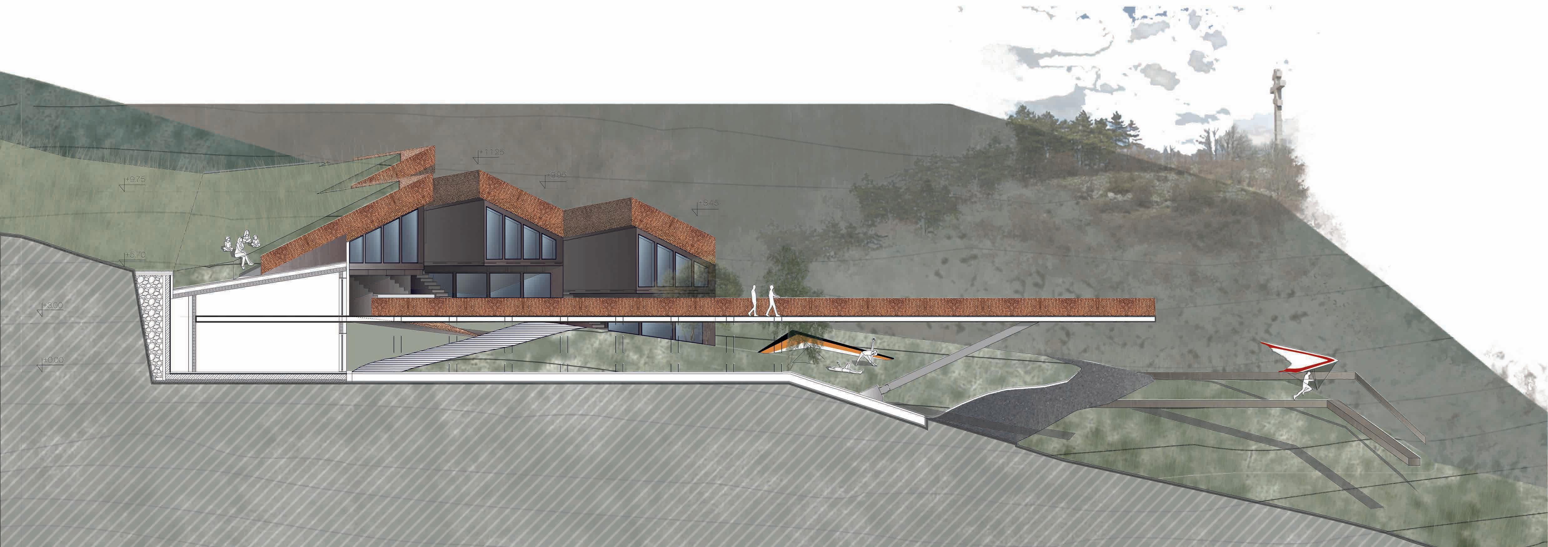
CONCEPT 7. SECTION A - A
+8.45 +11.25 +9.95 +9.75 +5.70 +3.00 ±0.00 0 5 10 20 m


SECTION B - B 1:100 DETAILS - CLT PANELS CONCEPT
+9.75 +5.70 +2.70
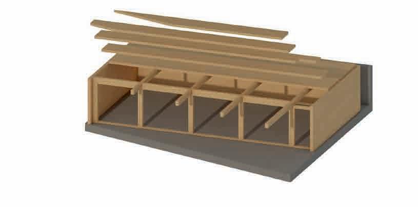
8. DETAILED FRAGMENT OF THE ACCOMMODATION UNIT
CONCEPT 8. DETAILED FRAGMENT OF THE ACCOMMODATION UNIT
FLOOR STRUCTURE +5.70 1:100 FLOOR STRUCTURE +5.70 1:100
+5.70 CLT PANELS CLT PANELS 8150 8150 12650 3350 3350 15000 15000 3350 1600 3350
CONCEPT 8. DETAILED FRAGMENT OF THE ACCOMMODATION UNIT

+9.75 +5.70 +2.70 +4.20 +7.20 +11.25
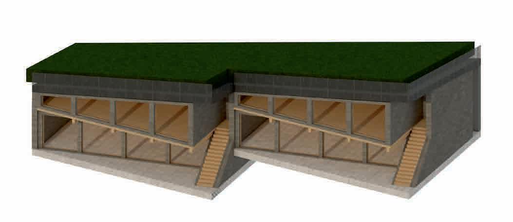
PROJECT 9. PERSPECTIVE VIEWS
PROJECT 9. PERSPECTIVE VIEWS
CONCEPT 10. SOURCES
Vrachanski Balkan Nature park
Mountain resorts, Petko Evrev
Agency of geodesy, cartography and cadastre
Agency of roads’ infrastructure
Wikipedia
tourism-bg.net
forum.deltaclub.bg
tramping.net.nz/huts-routeburn-greenstone-caples/ mantinela.blogspot.com
kartanavremeto-vratsa.org/story/654/32
Concept of the development of the paragliding and hang gliding practise - Vitosha Nature park