15 minute read
hacia la frontera oriental del tawantinsuyu


to the eastern frontier of tawantinsuyu
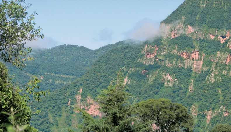
El borde oriental del Tawantinsuyu se caracteriza por una tupida vegetación selvática y por abruptos relieves que anteceden a las interminables llanuras amazónicas y chaqueñas. Para los incas, ésta fue una zona apetecida pero indómita y desconocida. Prácticamente no hubo rincón en toda el área andina que no haya sido conquistada o pretendida por los cusqueños. Para ello, se valieron principalmente de alianzas y acuerdos pacíficos, pero también llegaron a protagonizar cruentas confrontaciones allí donde fueron rechazados. Por eso, uno de los grandes y permanentes conflictos para los incas fueron los habitantes del borde oriental, con quienes debieron librar múltiples batallas y efectuar numerosas negociaciones con mayor o menor éxito.
Advertisement
Las etnias selváticas poseían una forma de organización social sin la centralización y la jerarquización andina, lo que generó mayores dificultades para un sometimiento masivo. Esto condujo a un panorama bastante difícil para los incas puesto que estas regiones ofrecían gran cantidad de materias primas y productos altamente cotizados por las culturas andinas, no solo para el uso doméstico, como metales, maderas, miel y frutos, sino también para el consumo ritual o como elementos que otorgaban prestigio social. Entre ellos figuraban coloridas plumas de aves tropicales, pieles de jaguar, especies silvestres de coca, plantas medicinales y especies psicotrópicas, tales como el cebil y la ayahuasca.
The Eastern frontier of Tawantinsuyu was a region of dense jungle and rugged topography that gave way to the vast plains of the Amazon and Chaqueña regions. For the Incas, this was a very attractive yet unknown and untamable land. There was virtually no corner of the Andean region that had not been conquered or claimed by the people from Cusco. For the most part the Incas relied on making peaceful, but they also unleashed bloody attacks in places where their offer was refused. One of the greatest ongoing conflicts they engaged in was with the inhabitants of this eastern frontier region, with whom they battled and negotiated with varying degrees of success.
The jungle societies were not centrally organized and hierarchical like Andean societies, which made it very difficult to conquer them en masse. This presented a major challenge for the Incas, as these regions offered many raw materials and products that were highly prized in the Andes. Some were for everyday use, such as metals, wood, honey and nuts, but others were valued as ritual items and prestige goods. These included colorful tropical bird feathers, jaguar hides, wild coca plants, medicinal plants and psychotropic substances such as cebil and ayahuasca chaco, purun y auca runa ~ Los temibles chiriguanos chaco, purun runa and auca runa ~ The dreaded Chiriguano
Una forma de acceso a tales recursos fue a través de la alianza con otras etnias que ya hubieran entablado contacto con los grupos orientales. Es el caso, por ejemplo, de la nación de los chichas del altiplano meridional de Bolivia, previamente conquistados por los incas, y que por su condición de grandes guerreros adquirieron un importante estatus social en el Tawantinsuyu. Entre otras actividades productivas, los chichas se incorporaron a los ejércitos del Inca como mitmakunas, es decir poblaciones trasladadas para el servicio del Estado, y se establecieron en los puestos de frontera para contener los avances de grupos guaraníes de la región, que azotaban esporádicamente la frontera oriental. Esta zona, correspondiente al borde noreste del Collasuyu se asociaba, desde la mirada geográfica y cultural incaica, al Antisuyu, es decir, la frontera selvática de las laderas orientales de los Andes, que en estas latitudes era denominada por los quechuas como El Chaco.
One way the Incas could obtain these resources was to enter into alliances with other ethnic groups that had already made contact with the peoples of the Eastern Jungle. The Chica people of the southern Altiplano region of Bolivia were a case in point: they had already been brought under Inca rule and their warriors, known for their imposing size, had attained high social status in Tawantinsuyu. Among other productive activities they engaged in, the Chica warriors served the Inca armies as mitmakunas—groups that were moved around at the State’s pleasure—establishing frontier outposts to control incursions by Guarani groups that occasionally raided the eastern borderlands. Culturally and geographically, this zone along the northeastern border of Collasuyu was known as Antisuyu by the Incas. It comprised the jungle frontier on the eastern slopes of the Andes and was also known as “El Chaco” among the Quechua people.
Los indígenas que habitaban el actual Chaco boliviano y argentino eran peyorativamente denominados chiriguanos por los incas y posteriormente serían también un dolor de cabeza para los conquistadores españoles. Los relatos de las primeras crónicas hispanas, aprendidos y escuchados de los propios incas, reflejan esta percepción de los guaraníes como un pueblo extremadamente “salvaje”:
The indigenous groups that inhabited the area known today as the Chaco region of Bolivia and Argentina were pejoratively called “Chiriguanos” by the Incas. These groups would later prove troublesome to the Spanish conquistadors. Accounts from the earliest Spanish chronicles, obtained from the Incas themselves, reflected their perception of the Guarani as an extremely “savage” people:
Los ambientes selváticos y agrestes eran habitados, según la mirada de los incas, por poblaciones que pertenecían a generaciones antiguas o arcaicas.
From the Inca perspective, jungles and wilderness areas were inhabited by peoples who belonged to ancient or archaic times.
La generación guerrera de los auca runa, desde la mirada del cronista indígena Guaman Poma de Ayala en 1614.
Auca runa from the perspective of indigenous chronicler Guaman Poma de Ayala en 1614.

“
También había y hay al presente unos indios de guerra los cuales comen carne cruda y humana; llámanse Chiriguanaes y Caribes, los cuales tienen muy perversas costumbres y fealdades, y siempre en tiempo del Inga las tuvieron; y cuando alguno dellos enferma, aunque sea de los más familiares y amigos y parientes más cercanos, los matan, y muchas veces los comen, porque dicen que no conviene que con la enfermedad se corrompan las carnes; y lo mismo hacen con sus propias mujeres e hijos o hijas…
(Martín de Murúa, 1615)
Also there were and still are some warrior Indians who eat raw meat and human flesh; they go by the name of Chiriguanaes and Caribes, and they have many depraved and ugly customs, and they have had them since the time of the Inga [Inca]; and when one of them becomes ill, even an immediate family member, friend or close relative, they kill them, and very often eat them, because they say it is better not to let the disease corrupt the meat; and they do the same with their own women and sons or daughters …
(Martín de Murúa, 1615)
Por su condición de poblaciones de frontera y como era el caso de la mayoría de las culturas consideradas “distintas” por los incas, los chiriguanos fueron categorizados como purun y auca runa
Las culturas que no pertenecían al mundo del Inca y de sus aliados, eran consideradas como sociedades del pasado, correspondientes a edades o generaciones antiguas. Los purun y auca runa pertenecían a una época anterior a la era del Inca y al estado de “orden social” que ésta representaba. Pero no se trataba de generaciones extinguidas. Sus “restos” seguían coexistiendo con los tiempos incaicos y representaban a aquellos grupos humanos considerados como en estado “salvaje”. Estos mitos andinos simbolizaban las diferencias étnicas y culturales desde la perspectiva de las sociedades dominantes.
Like most cultures that the Incas considered “different”, and especially because they were frontier groups, the Chiriguanos were classified as purun runas and auca runa
Cultures that were not part of the world of the Incas and their allies were considered societies of the past, leftovers from ancient times or past generations. The purun runa and auca runa were thought to belong to an era before that of the Incas and the “social order” that they represented. They were not considered extinct societies. Their “remains” continued to exist during Inca times and were thought to represent humans in a “savage” state. These Andean myths addressed existing ethnic and cultural differences from the perspective of the dominant society.
La adaptación de la ingeniería vial incaica a las condiciones extremadamente húmedas de esta región, permitió la conservación de caminos y escalinatas de piedra.


En el caso de los incas, este discurso se proyectaba especialmente hacia aquellos grupos que se encontraban en los márgenes o en los “límites del mundo”, es decir, del Tawantinsuyu Los purun runa eran quienes procedían de un tiempo muy antiguo, de cuando aún no había Sol. Generalmente vivían de la caza y recolección, más que de la agricultura. Políticamente, se trataba de quienes no tenían “ley ni rey”, es decir, que no estaban sometidos a un gobierno central. Por su parte, los auca runa eran de un tiempo posterior, pero marcado por el desorden, la guerra y la ingobernabilidad.
La toponimia chacu (chaco), estaba también asociada a estas diferencias. Aludía a la idea de desorden, de formas distintas de subsistencia, de “inferioridad” étnica y de marginalidad; al concepto de frontera cultural y geográfica. De allí que la región conocida como El Chaco, en las selvas orientales de Bolivia y del norte de Argentina, fuera la que designara a este territorio de frontera simbólica, ecológica y social. Sus habitantes, los chiriguanos, nunca llegaron a ser sometidos por el Tawantinsuyu
Sin embargo, aunque desde las voces incas y desde los escritos españoles se haya insistido en que éste fue un espacio de permanentes confrontaciones, las investigaciones arqueológicas han revelado la existencia de una serie de sitios y caminos vinculados al Tawantinsuyu, sugiriendo una frontera más permeable y dinámica que defensiva o militar. La explotación minera, la construcción de terrazas de cultivo, de pequeños poblados y centros administrativos, de lugares ceremoniales y de una red de caminos construidos y adaptados a este abrupto y húmedo territorio, son testimonio de una “convivencia” mayor a la que establecen los relatos épicos incaicos, señalando un vínculo más estrecho entre el mundo del altiplano andino y el de la selva.
In the case of the Incas, this discourse was projected especially onto groups that lived on the margins or the “edge of the world”, meaning on the edge of Tawantinsuyu. The purun runa, then, were considered people from an ancient time, before the birth of the Sun. They usually lived by hunting and gathering rather than by farming. Politically, they were groups that had “neither law nor king”, meaning that they were not ruled by a central government. The auca runa were thought to be from a later time, but one plagued by disorder, war and ungovernability.
The place name Chacu (Chaco) was associated with these different groups, and alluded to the idea of disorder, of different modes of subsistence, ethnic “inferiority” and marginality; it contained the concept of the cultural and geographic frontier. Thus the region known as El Chaco, in the eastern jungles of Bolivia and Northern Argentina, referred to a symbolic, ecological and social frontier land. Its inhabitants, the Chiriguanos, never came under the rule of Tawantinsuyu
However, although the Incas’ own voices and accounts left by the Spanish describe the region as an arena of ongoing confrontation, archeological investigations have uncovered a series of sites and roads associated with Tawantinsuyu, suggesting that the frontier was more permeable and fluid and not simply defensive or military. Mining operations, agricultural terraces, small settlements and administrative centers, ceremonial sites and a network of roads built and adapted to this rugged, tropical territory all bear witness to a greater degree of “coexistence” than that conveyed in the epic Inca narratives, pointing to a closer linkage between the world of the Andean Altiplano and that of the jungle.
Camino se desplaza sobre los de neblina, en

Un Paisaje De Frontera
a landscape from a frontier
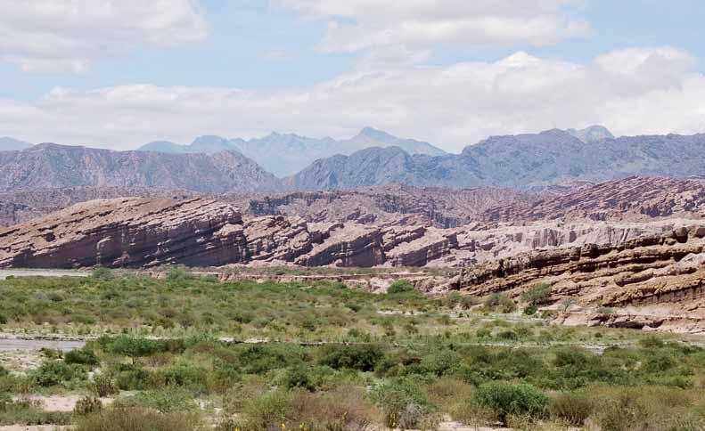
La serranía de Calilegua se localiza en los departamentos Valle Grande y Ledesma en los actuales límites argentino-bolivianos. Se inserta en el último cordón montañoso andino que se enfrenta a la extensa llanura chaqueña. Estas montañas constituyen una barrera orográfica que cautiva los vientos húmedos del Atlántico dando lugar a una franja selvática denominada comúnmente “yungas”. El relieve de la serranía, dominado por los cerros Amarillo (3.600 m) y Hermoso (3.500 m), alterna cumbres, mesetas de altura y estrechos valles. La zona se identifica por su notable biodiversidad y su gradiente altitudinal demarca cuatro pisos ecológicos muy diferenciados. En su base, la selva pedemontana de bosques tropicales se extiende hasta los 700 metros. Más arriba, la selva montana de laderas abarca hasta los 1.500 metros, recibiendo altísimas precipitaciones pluviales. Sobre este nivel y hasta los 3 mil metros, se encuentran los bosques montanos, de escarpado relieve, llamados también “bosques nublados”. Finalmente, por encima de los 3 mil metros, los pastizales de neblina coronan un abrupto territorio montañoso cuyas cumbres sobresalen por sobre las nubes.
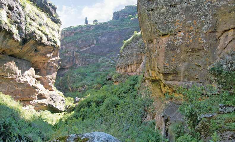
Algunas de estas montañas selváticas fueron transformadas en santuarios de altura, como es el caso del cerro Amarillo, que alberga un prominente espacio ceremonial compuesto por un conjunto de siete plataformas distribuidas sobre el filo, construidas con espesos y elevados muros de pirca. A escasos 4 kilómetros al sur se localiza otro santuario sobre la cumbre del cerro Hermoso.
El dominio visual que se alcanza en la localización particularmente extrema de las plataformas del cerro Amarillo, dispuestas sobre el borde de un
The Calilegua range is located in the departments of Valle Grande and Ledesma, on the presentday Bolivia-Argentina border. It is part of the last mountain chain before the Andes give way to the vast Chaqueña plain. These mountains act as an orographic barrier that captures the humid winds from the Atlantic Ocean, producing a stretch of jungle that is commonly called “Yungas”. The landscape here is dominated by the peaks of Amarillo (3600 m) and Hermoso (3500 m), its soaring peaks alternating with high plateaus and narrow valleys. The area boasts outstanding biodiversity and an altitude gain that envelops four very distinct ecological strata. At its base, the piedmont tropical forest extends up to 700 meters above sea level. Further up, the montane hillside jungle extends up to 1500 meters, and receives extremely high precipitation. The montane forest, also called the “cloud forest”, covers the steep slopes above this altitude up to 3000 meters. Lastly, above 3000 meters the high-altitude grasslands lay like a garland upon this rugged land of mountains, the summits of which rise above the clouds.
The Incas transformed some of these jungle-covered mountains into high-altitude shrines. One of them is Cerro Amarillo, which contains an outstanding ceremonial complex consisting of seven platforms distributed along a mountain ridge and built of thick, elevated dry stone walls. Another shrine is found just four kilometers south, on the summit of Cerro Hermoso.
The commanding view from the Cerro Amarillo platforms, which are situated on the edge of a deep, cloud-covered precipice, expresses the Incas’ ritual
La abrupta gradiente altitudinal determina importantes diferencias en profundo precipicio y frente a densas masas de nubes, es una expresión de que los incas se encontraban en un proceso de conquista ritual de este indómito espacio. Creando lugares e hitos sagrados, buscaban el dominio del nuevo ambiente, de sus recursos y de sus habitantes.
The sharp altitude gradient determines significant differences in rainforest ecological environments.

La metalurgia fue uno de los principales intereses de los incas en el borde selvático oriental, como se aprecia en estas piezas de estilo incaico halladas en sitios arqueológicos de la región.

Metallurgy was one of the main activities of the Incas on the eastern, rainforest edge of their territory, as shown by these Inca-style pieces found in the region’s archeological sites.

Estos espacios rituales están asociados a otros puntos de carácter productivo, como yacimientos mineros y lugares de cultivo. Los sitios e instalaciones se encuentran integrados entre sí por senderos y caminos empedrados y con escalinatas que conforman una red que recorría la serranía de Calilegua y se conectaba al norte con un ramal del Qhapaq Ñan. Los múltiples recursos económicos del área explican la energía invertida por el Tawantinsuyu en su expansión meridional en donde, una vez más, podemos apreciar una voluntad de apropiación simbólica de ese espacio a través del establecimiento de santuarios y de redes de caminos.
De acuerdo al relato de Juan de Betanzos, luego de enfrentarse y dar batalla a los chiriguanos, Tupac Inca Yupanqui continuó hacia el sur por la llanura chacopampeana, hacia la tierra de los zuríes: conquest of this indomitable space. Indeed, the Incas created such sacred spaces and landmarks to exert control over new environments, their resources and inhabitants.
These ritual spaces are associated with other sites that were built for productive purposes, such as mining operations and agricultural fields, and all were connected to each other by a network of trails, stone paths and staircases that ran through the Calilegua range and joined up in the north with a branch of the Qhapaq Ñan. The many economic resources available in the area explain the energy that the Empire of Tawantinsuyu invested in expanding southward, where again we see the expressions of the Incas’ desire to symbolically appropriate spaces by establishing shrines and trail networks.
According to an account written by Juan de Betanzos, after coming upon the Chiriguanos and engaging them in battle, Tupac Inca Yupanqui continued southward across the Chacopampeana plain toward the land of the “Zuri” people:
“Tuvo noticia de la provincia de los zuríes y mandó encaminar su campo para allá y como a ellos llegasen, tuvo con ellos su batalla y reencuentro e al fin los venció y sujetó (…) La gran provincia es de grandes montañas y tierras donde hay muchas avestruces y la más ropa que los naturales desta provincia visten es de pluma de aquellos avestruces.
(Juan de Betanzos, 1551)
He received word about the province of the Zuríes and sent his troops, which, upon arriving, engaged them in battle twice, finally defeating them and subjugating them (…) This great province is a land of high mountains and is populated by many ostriches, and the clothing of the people there consists of little more than the feathers of those ostriches.
(Juan de Betanzos, 1551)
Samaipata, el principal centro ceremonial incaico de la vertiente oriental andina. Se puede observar la roca labrada y las bases de lo que fue una imponente kallanka de 75 metros de largo.
Samaipata, the main Inca ceremonial center of the eastern slopes of the Andes. The carved stone and bases of a significant kallanka, 75 meters or 250 feet long, can be made out.


El nombre zuríes proviene de zuri, el pequeño avestruz andino. Estas poblaciones, también vistas como purun runa, habitaban la actual región argentina de Santiago del Estero. El Inca, luego de vencerlos, continuó bordeando las fronteras orientales hasta alcanzar el Río de la Plata, desde donde decide torcer su rumbo y cruzar hacia Chile. El relato de Betanzos no nos entrega mayores detalles de las hazañas del Inca en un territorio de tal relevancia para el Tawantinsuyu como lo fueron las quebradas y valles orientales de la cordillera de los Andes.

Se estima que la presencia inca en estas vastas regiones del noroeste argentino se fue desarrollando entre los siglos XIV y XV. Es decir, bajo sucesivos gobernantes, los incas habrían ido conquistando territorios y poblaciones correspondientes a las actuales provincias de Jujuy, Salta, Catamarca, La Rioja, San Juan y parte de Tucumán y de Santiago del Estero. Sin embargo, si siguiéramos literalmente lo que nos relatan los cronistas del
The name “Zuri” is taken from the word “Suri”, the name for the small Andean ostrich. These peoples, who were also considered purun runa, lived in what is now the Argentinean region of Santiago del Estero. After defeating them, the Inca continued along the eastern frontier until reaching Río de la Plata, from whence he decided to change course and head in the direction of Chile. Betanzos’ account, however, gives no further details of his exploits in the valleys and ravines of the Eastern Andes Mountains, a territory that was highly important to Tawantinsuyu
It is believed that the Incas were present in these vast regions of Northwest Argentina in the 14th and 15th centuries. In other words, under successive rulers the Incas conquered territories and peoples in the present-day provinces of Jujuy, Salta, Catamarca, La Rioja, San Juan and parts of Tucumán, as well as Santiago del Estero. However, if we take literally the accounts left by the chroniclers of Tawantinsuyu itself, we would have to believe that the main figures of this period—Pachacuti Inca Yupanqui and Tupac Inca Yupanqui—lived and ruled for more than a hundred years in order to have accomplished all the deeds attributed to them by the nobles of Cusco. In fact, history and political memory were often reinterpreted by later generations of incas as they rose to power, allowing them to situate and even adjust past and present events and simultaneous and cyclical acts of conquest within a timeframe that was imprecise. In this context, it can be useful to examine some contributions from regional archeology from the past few decades, while not distancing ourselves too much from our original sources.
Tawantinsuyu, deberíamos asumir, por ejemplo, que los héroes principales de nuestros relatos, Pachacuti Inca Yupanqui y Tupac Inca Yupanqui, habrían vivido y gobernado más de cien años para poder cubrir todas las hazañas que la memoria de las elites cusqueñas les atribuye. La historia mítica y la memoria política, constantemente reinterpretada por los sucesivos linajes incas que asumían el poder, permitía ajustar o situar en un tiempo impreciso, de pasado y de presente, simultáneo y cíclico, todos estos procesos de conquista. Resulta interesante, sin la intención de desprendernos de la lectura de nuestras fuentes de origen, detenernos brevemente en algunos aportes de la arqueología regional de las últimas décadas.