3 minute read
cruzando el umbral de vaquillas


Hacia el corazón del Despoblado
crossing the vaquillas threshold Into the heart of the ‘Unpopulated Lands’
Advertisement
Una vez en el portezuelo, se inaugura hacia el norte un espacio y un paisaje notablemente diferente. Hasta esa altura, la sequedad del ambiente se veía aplacada en alguna medida por un sistema de quebradas y hoyas hidrográficas que regaban con sus aguas intermitentes las faldas cordilleranas en un sentido este-oeste pudiendo favorecer el acceso a vegas o pastizales más altos con relativa frecuencia. Ahora, cruzando Domeyko por Vaquillas, entramos a la gran cuenca del salar de Punta Negra y al corazón del Despoblado. Desde el portezuelo se abre hacia el norte una amplia meseta cuyas alturas promedian los 4 mil metros. Al noreste, el imponente volcán Llullaillaco domina toda la cordillera andina y el paisaje general de la cuenca; es aquí donde se registran las condiciones más duras de la travesía. En general, la meseta supera los 4 mil metros y está muy expuesta a los fuertes y fríos vientos que soplan durante el día y a las gélidas temperaturas de la noche. Desde el portezuelo, que se aprecia como un amplio umbral señalado en sus extremos por pequeñas y arenosas colinas, el camino del Inca desciende por una suave pendiente y dibuja un recto trazado durante unos 20 kilómetros. No obstante sus condiciones extremas éste es uno de los tramos con mayor densidad de restos arqueológicos de todo el trayecto, entre otros, refugios y paravientos asociados a actividades de caza, pastoreo y tráfico caravanero.
The pass to the north marks the beginning of a notably different landscape and space. Up to this point, the aridity of the environment had been offset somewhat by a system of ravines and water basins that irrigated the foothills with their seasonal eastto-west flows, providing access to many upland meadows and grasslands. Now, crossing the Domeyko Range over the Vaquillas Pass, we enter into the great basin of the Punta Negra salt flat and the heart of the Unpopulated Lands. The pass leads to a broad meseta to the north, with an average altitude greater than 4000 meters above sea level. Northeast, the imposing Llullaillaco Volcano towers above the Andean skyline and the landscape of the basin. This is the harshest part of the journey. The meseta remains generally above 4000 meters and is very exposed to the strong, frigid daytime winds and freezing nighttime temperatures. From the pass, which looks like a broad doorway with small, sandy hills on either side, the Inca Trail descends down a gentle slope and runs in a straight line for some 20 kilometers. Despite the harsh conditions here, this segment of the trail boasts one of the highest concentrations of archeological remains in the entire Inca Trail system, including refuges and wind shelters associated with hunting activities, herding and caravan traffic, among other things.
Aquí, a escasos kilómetros del inicio del descenso desde el portezuelo de Vaquillas, es donde se encuentran las sayhuas o columnas del camino inca que, según las crónicas del siglo XVI, señalaban una importante frontera:
“
Here, just a few kilometers beyond the Vaquillas Pass, are a series of sayhuas or stone columns that mark an important border, according to 16th Century chronicles:
Están en este valle los mojones altos y grandes que dividían las provincias de Chile de las del Perú en tiempo de los Ingas, y en medio de él un arroyo pequeño que se dice Auchillulca, que quiere decir “muy mentiroso”, porque a ciertas horas del día llega el agua del al camino real del Inga, a causa de que se hiela en su nacimiento y solo corre cuando hay sol. ”
(Juan López de Velasco, 1574)
“There are in this valley large, high markers that divided the provinces of Chile from those of Peru during Inca times, and in the middle of it, a small stream that is called Auchillulca, which means “big liar”, because the water only reaches the Royal Inca Trail at certain times of the day, because it freezes at its source and only flows when the sun shines. ”
(Juan López de Velasco, 1574)
¿Qué podía significar esta “frontera” en pleno Despoblado de Atacama y en medio “de la nada”? ¿Qué relación podía tener con ella un río “mentiroso” que solo corría con el sol?
What could this “border” be, in the heart of the Unpopulated Atacama and in the middle of nowhere? What relation could it have with a “big liar” river that only flows when the sun shines?
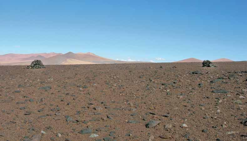
Vista desde el norte de las sayhuas del portezuelo de Vaquillas, umbral simbólico y fuertemente sacralizado por los incas. La erosión, sin embargo, no permite visualizar el camino en la actualidad.
View from the north sayhuas of Vaquillas Pass, a symbolic threshold that was very sacred to the Incas. Today, however, erosion has rendered the trail invisible.


