8 minute read
del


Inca y
The Empire Expands
Advertisement
The mythical journey of the Inca and the Sun
Así como Pachacuti Inca Yupanqui encarnó un rol político y simbólico de gran importancia al poner nuevamente el mundo en “orden”, su sucesor Tupac Inca Yupanqui, destacó como un gran estratega político y militar y como el Inca que conquistó definitivamente al Collasuyu en toda su inmensa extensión y hasta sus confines meridionales. Guayna Capac, quien lo sucedió en el poder, hizo otro tanto, consolidando la conquista del Ecuador y estableciendo las fronteras septentrionales del Chinchaysuyu en Pasto, actual territorio colombiano.
Los españoles escucharon y transcribieron los relatos incas sobre estos procesos de conquista y, gracias a ello, podemos conocer cómo los incas narraban sus hazañas siempre asociando el avance del Imperio con la construcción o la extensión de sus caminos. Varios relatos incaicos registrados en la conquista refieren, más que a acontecimientos históricos, a recorridos míticos que asocian el desplazamiento del Inca con el circuito o desplazamiento anual del Sol. A través de estos relatos los dos grandes caminos —el de “la Sierra” al este y el de “los Llanos” al oeste— demarcan la ruta ritual del Inca y de Inti, y representan aspectos fundamentales de la cosmología de los fundadores del Imperio.
Just as Pachacuti Inca Yupanqui played a highly important political and symbolic role in the reorganization of the Inca world, his successor Tupac Inca Yupanqui was celebrated for being a great political and military strategist and the leader responsible for conquering the vast expanses of Collasuyu, to its southernmost reaches. Guayna Capac, who succeeded him, also made his mark with the conquest of Ecuador and the establishment of the northern Inca border of Chinchaysuyu near the modern day town of Pasto, Colombia.
The Spanish listened to the Incas’ tales of these conquests and wrote them down, and thanks to them we can hear the Incas’ own stories of their exploits—always associating the expansion of the Empire with the construction or extension of its trails. Many Inca stories of conquest and expansion refer less to historic events and more to mythical journeys that link the Inca advancement with the annual circuit of the Sun. Through these stories the two great trails—that of the Mountains in the East and the Plains in the West—delineate the ritual path of the Inca and the Inti and represent fundamental aspects of the cosmology of the founders of the Empire.
El circuito anual del Sol representaba un conjunto de acontecimientos de profunda significación para los incas. El calendario cusqueño combinaba los ciclos solares (solsticios y equinoccios) con los meses y ciclos de la Luna (quilla, en quechua), y con la observación de los movimientos siderales. Estos ciclos astrales eran simbolizados como el recorrido que realizaba Inti (el Sol) durante el año andino. El solsticio es el momento en que el Sol llega a los puntos extremos, al norte o al sur, de su aparente movimiento con respecto a la línea ecuatorial. Es decir, el punto más septentrional o meridional donde sale y se pone en el transcurso de un año. A partir de ese momento, el Sol comienza a “devolverse” para completar su circuito. Esta fase del calendario andino es considerada, hasta la actualidad, como un período en que el Sol “se detiene” en el cielo para luego recomenzar su regreso. En la tradición oral incaica, como lo relata el cronista indígena Guaman Poma de Ayala, el solsticio, que puede abarcar algunos días, era simbolizado como aquel momento en que el Sol “se sentaba en su silla”, para luego comenzar a “caminar sin descansar” en sentido contrario. Es decir, desde su silla en el sur, el Sol “caminaba” de enero hasta junio por el oeste, hasta su “silla” en el norte, y de allí por el este, hasta su “silla” en el sur, describiendo una circunferencia en el sentido del reloj.
Estos mitos permitían explicar los calendarios productivos del año y la organización de las festividades religiosas del Estado inca, pero a la vez representaban el discurso político del dominio y de la expansión incaica por las regiones más extremas del Tawantinsuyu. Los procesos de conquista de nuevos territorios, la paulatina apropiación del espacio andino y de sus ambientes ecológicos tan diversos, eran pensados y relatados por los sabios del Imperio, los quipucamayoc, como el recorrido sacralizado que los propios gobernantes incas, teniendo al Cusco como origen y centro, seguían al conquistar nuevas provincias.
The annual circuit of the Sun envelops several events of profound significance to the Incas, whose calendar combines the solar cycle of solstices and equinoxes with the months and cycle of the moon (quilla, in Quechua), and with astronomical observation. These astral cycles were symbolized by the journey made by Inti during the Andean yearly cycle. The solstice is the time when the sun’s apparent position in the sky is furthest from the equator; in other words, it is the southernmost (or northernmost) point at which the sun rises and sets during the year. At that time, the Sun begins to ‘return’ to its previous position, thus completing the cycle. Even today this phase of the Andean calendar is thought of as the time when the Sun stops in the sky before continuing with its return journey. In the Inca oral tradition, as related by the indigenous chronicler Guaman Poma de Ayala, the period of the solstice—which can cover several days—was characterized as the time when the Sun ‘sat down in its chair’ to then begin its ‘tireless trek’ in the opposite direction. That is, from its chair in the South, the Sun ‘walked’ to the West from January until June, reaching its chair in the North, and then journeyed eastwards back to its chair in the South, thus describing a circle in a clockwise direction.
These descriptions provided a rationale for the yearly agricultural calendar and the organization of the Inca State’s religious festivals, but they also represented the discourse of Inca political domination and expansion to the furthest reaches of Tawantinsuyu. The conquest of new territories and the gradual appropriation of the Andean space and its widely diverse ecological environments were envisioned and spoken of by the quipucamayoc, the elders of the Empire, as the sacred journey that the Inca rulers themselves undertook to conquer new provinces, always with Cusco as the origin and centre.


Según estas tradiciones orales, el circuito de Tupac Inca Yupanqui, uno de los principales conquistadores incas y sucesor de Pachacuti, se inicia en el valle sagrado cuando envía a sus ejércitos en las cuatro direcciones de los suyus, tomando él personalmente el camino del Collasuyu. Saliendo del Cusco, el Inca comienza un itinerario por el este en dirección al Titicaca en la provincia de los collas o aymaras, desde donde continúa hacia el sur sometiendo los valles sudorientales de Bolivia (chichas), cerca de la frontera con la selva. Al igual que el trazado del camino “de la Sierra”, sigue por el oriente de los Andes hacia el sur. Luego atraviesa de este a oeste la cordillera y conquista los valles centrales de Chile. Desde allí “amojona” los límites meridionales del Imperio y recomienza su circuito por el oeste hacia el norte, hasta arribar y someter al valle de Copiapó. Se interna después por la travesía del gran Despoblado hasta la “provincia” de Atacama. Una vez allí, nuevamente divide a sus ejércitos en cuatro caminos, tomando él mismo el de los Lípez, hacia el altiplano sur de Bolivia, para finalmente volver victorioso a la capital del Cusco.
La memoria oral sobre el gobierno de Tupac Inca Yupanqui destacaba, entre sus múltiples hazañas, la construcción o creación de los caminos de la sierra y de los llanos en la región del Collasuyu, es decir hacia el sur del Cusco. A su sucesor, Guayna Capac, se atribuía un modelo similar, esta vez hacia el norte. Como señala el cronista Zárate, en 1555, este Inca había partido desde el Cusco con el objeto de conquistar la provincia de Quito, para lo cual se le construyó un camino por la cordillera y, a su regreso, otro por los llanos.
According to these oral histories, Tupac Inca Yupanqui, successor of Pachacuti and one of the leading Inca conquerors, began his circuit in the sacred valley when he sent his armies in the four directions of the suyus, taking for himself the path to Collasuyu. Departing Cusco, the Inca set off eastwards towards Titicaca, in the province of the Collas or Aymaras, from whence he continued southwards, subjugating the southeastern valleys of modern day Bolivia (Chichas), coming almost to the edge of the Amazon rainforest. Like the route followed by the Trail of the Mountains, he continued southward along the eastern side of the Andes. He then cut west over the mountains and conquered the central valleys of what is now Chile. There he marked the southern border of the Empire and continued his journey to the west and then northwards, conquering the valley of Copiapó. From there he journeyed across the great Unpopulated Lands to the ‘province’ of Atacama. There, he once again divided his army into four, personally leading one segment towards Lípez, in the southern Altiplano of Bolivia, and finally returned victorious to the capital of Cusco.
The oral history about the rule of Tupac Inca Yupanqui highlights, among his other feats, the construction or creation of both the mountain and plains trails in the region of Collasuyu, to the south of Cusco. A similar achievement is attributed to his successor, Guayna Capac, in this case to the north. In the words of the chronicler Zárate, in 1555, the latter Inca departed Cusco with the aim of conquering the province of Quito, building a trail through the mountains for that purpose and another trail through the plains on his return.
Estos recorridos de ida y vuelta por distintos caminos, estableciendo un circuito, recuerdan las ceremonias del Inti Raymi o Fiestas del Sol, en las que se efectuaban muchos sacrificios a las wakas de la región del Cusco al amanecer, al mediodía y al ocaso, y donde las procesiones seguían un itinerario circular en el que “iban por un camino y volvían por otro”. En ese sentido, los recorridos míticos de conquista de Tupac Inca Yupanqui en el “hemisferio sur” y de Guayna Capac, que parece simbolizar el “hemisferio norte”, reproducen los movimientos aparentes del Sol e inscriben en el espacio sometido el orden cósmico simbolizado a través de los caminos del Inca.
These return trips that involved taking different paths on the outward and return journeys, thus establishing a circuit, are reminiscent of the ceremonies of Inti Raymi, the Feast of the Sun. At these events, many sacrifices were made to the wakas in Cusco region at dawn, noon, and sunset, the processions following a circular route in which they ‘left by one path and returned by another’. In this regard, the legendary journeys of conquest made by Tupac Inca Yupanqui in the ‘southern hemisphere’ and Guayna Capac, who seemed to have symbolized the ‘northern hemisphere’, reproduced the apparent movement of the Sun and inscribed the cosmic order upon the spaces they conquered in the symbolism of the Inca Trail.

Collasuyu
Voces en el Camino
~ Parte 2 ~ collasuyu
Voices from the Road
~ Part 1 ~
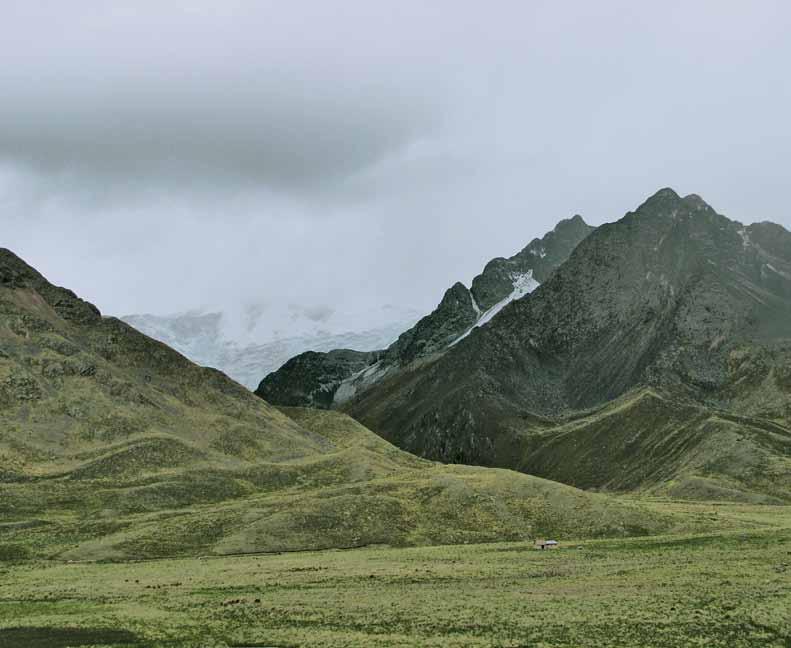
En el abra o portezuelo de La Raya, los incas establecieron una frontera simbólica con los collas. En la actualidad es el límite entre los departamentos peruanos de Puno y Cusco.
At the pass or gateway of La Raya, the Incas built a symbolic boundary between the Collas. This is currently the border between the Peruvian regions of Puno and Cusco.