

MetroNetworkandTODtimeline
LocationofNCR,Delhianditssatellitetowns
Delhianditssatellitetowns
Since1901to2031 nGhaziabad
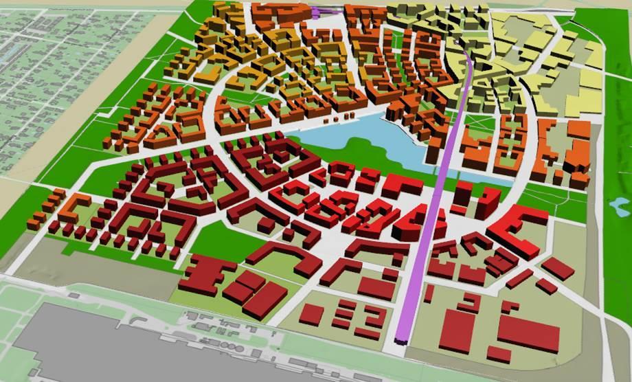
MapshowingareaofstudyandinterventionwithinGhaziabadcity
available
Existingpopulationdensity(inPPH)withinInfluenceZoneArea
landuseonexisting/proposedpublictransitfacilities
FARutilizationoncommercialandotherplotsgreaterthan0.5haarea
ProposedRoadhierarchymapandcompletingthegrid
ofstudyarea
Existingandproposedlandusearea(inha)withinInfluenceZoneArea
AssumptionsforotherLandUses(Commercial,Industrial,Institutionaletc.)


This model was developed to
Historyofurbantransportmodes


were known as transit adjacent
 Copenhagen’sFingerPlanconceptofTOD
structure
Copenhagen’sFingerPlanconceptofTOD
structure
Values(Vs)ofTODShowingbenefitsofTODkindofdevelopment
Disadvantages:
Implementationsteps
Implementationsteps
Implementationsteps
Implementationsteps
ContextofTOD
DifferentscalesofTOD(stationareas)
DifferentstakeholdersinTODprocess
ThemesofTOD

2ConvenientaccesstoPublicTransit
Singaporecityanditssatellitetowns
SingaporeTODstrategy
Location
RailNetworkalonghighdenseareas
Skylineandrailways
Locationandgrowth
DDA Delhi,
MetroNetworkandTODtimeline
TODtimelinestrategyatbuiltlevel
indicatorsofTOD


 National Capital Region (NCR), India
PopulationgrowthofDelhi
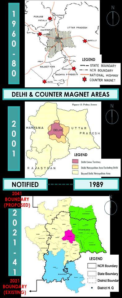
ofNCR
(Survey,2006)


 HistoricaltimelineofGhaziabadcity
HousingandEconomicprofileofGhaziabad
HistoricaltimelineofGhaziabadcity
HousingandEconomicprofileofGhaziabad
ExistingLandcovermapofGhaziabadcity
Ghaziabadcity
Publictransportationanalysis,Ghaziabad inGhaziabad inGhaziabad
RegionalcommuteperdayviarailwaysinGhaziabad
SWOTanalysis,Ghaziabad
MapshowingareaofstudyandinterventionwithinGhaziabadcity
inGhaziabadcity
DifferencebetweenRRTSandMetro
OverallimpactofRRTSonNCR
Delhi

areawithmodepreferencetoreachmetrostation
Sahibabadstudyarea
vertically stretching on outer roads with large commercial areas in front. Industrial
Sahibabadstudyarea
Sahibabadstudyarea
 Sahibabad
Sahibabadstudyareawithmodepreferencetoreachmetrostation
Sahibabadstudyarea
Land zone of RRTS station Sahibabadstudyarea
Sahibabadstudyarea
Sahibabadstudyarea
Sahibabad


ProposedlandusezonesforInfluenceZoneArea
Existingpopulationdensity(inPPH)withinInfluenceZoneArea
ConsiderationsfromtheUttarPradeshTODpolicy

FARutilizationonresidentialplotsgreaterthan0.5haarea
Existingscenarioofstreetswithinstudyarea
)


