YORKS ISLAND RANCH 8278 Hwy 287, Townsend, Montana Presented by Trent Lister of PureWest Ranches & Mike Schlauch of Platinum Properties PureWest Christie’s

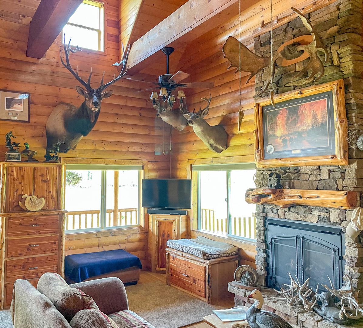
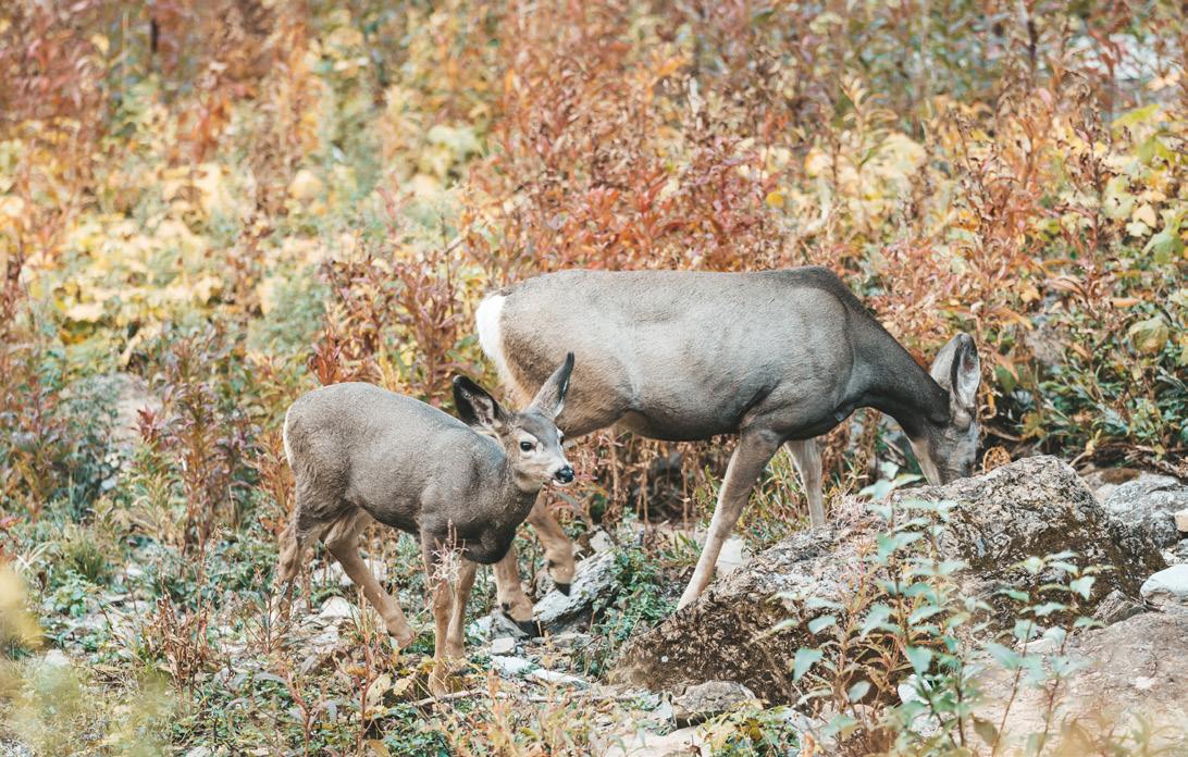
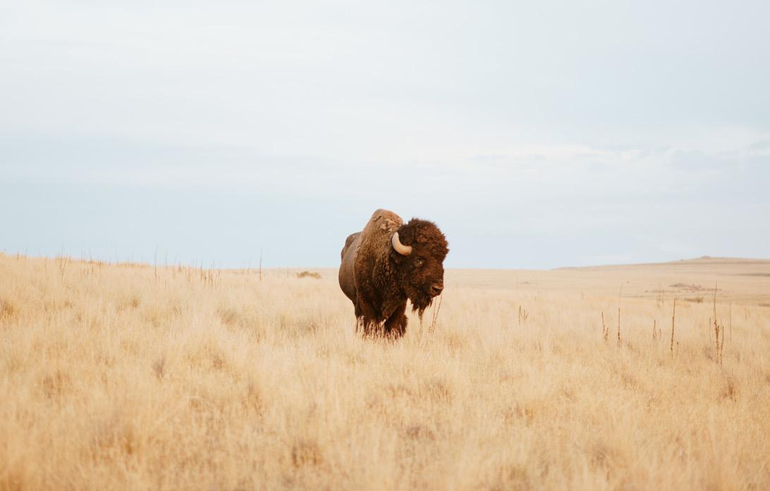
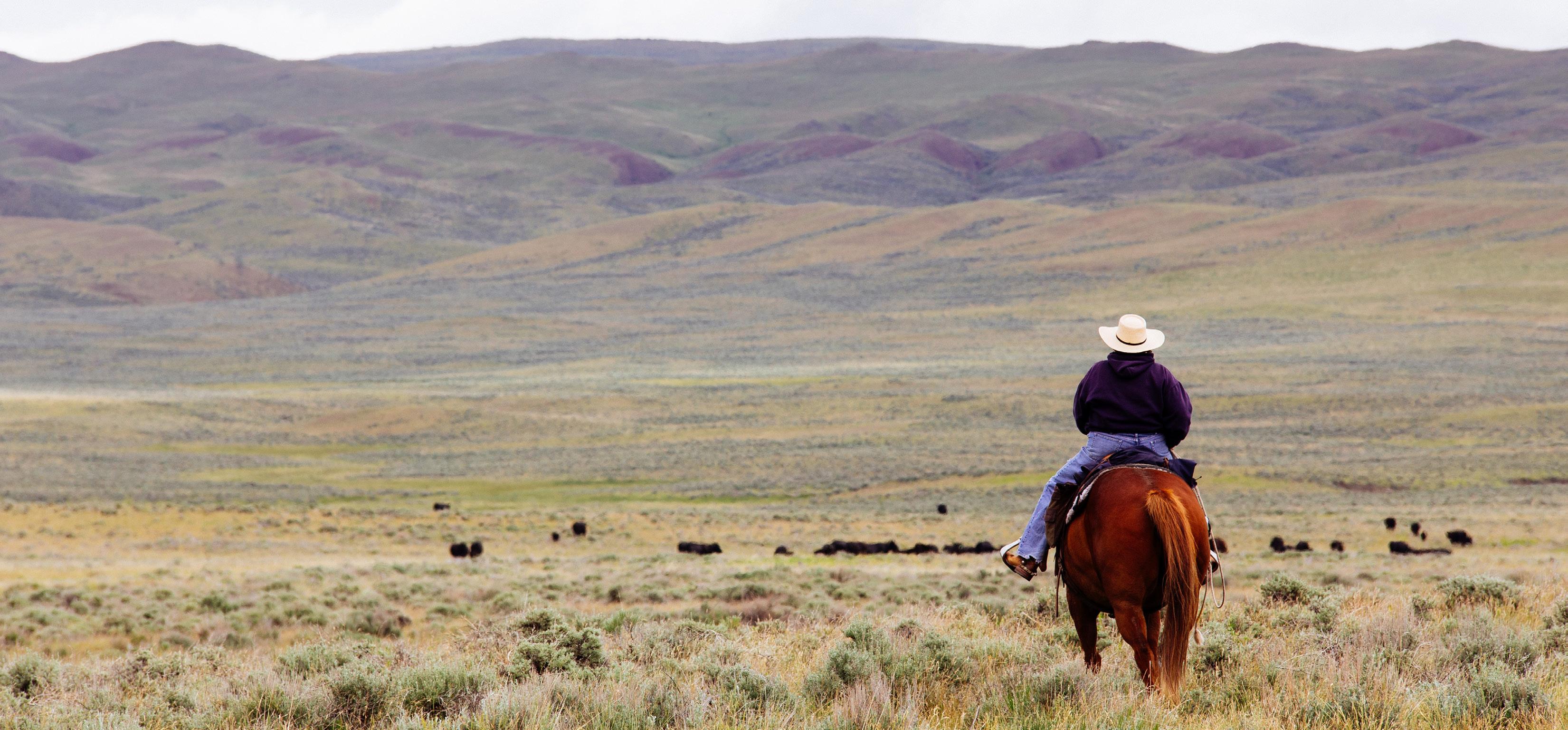
The recreational aspects of this property are second to none, between the upland bird and waterfowl hunting opportunities to the lush green river bottoms that provide the perfect sanctuary for elk to feed during the fall and winter, this property is a sporting paradise. In addition, the ranch has been developed as a world-class dog training facility, specializing in Labrador Retrievers.
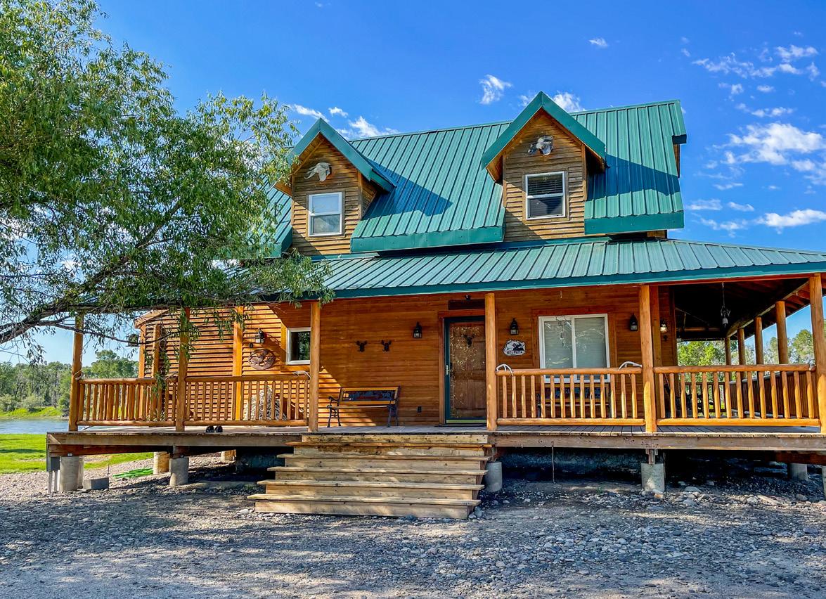
Welcome To YORKS ISLAND RANCH
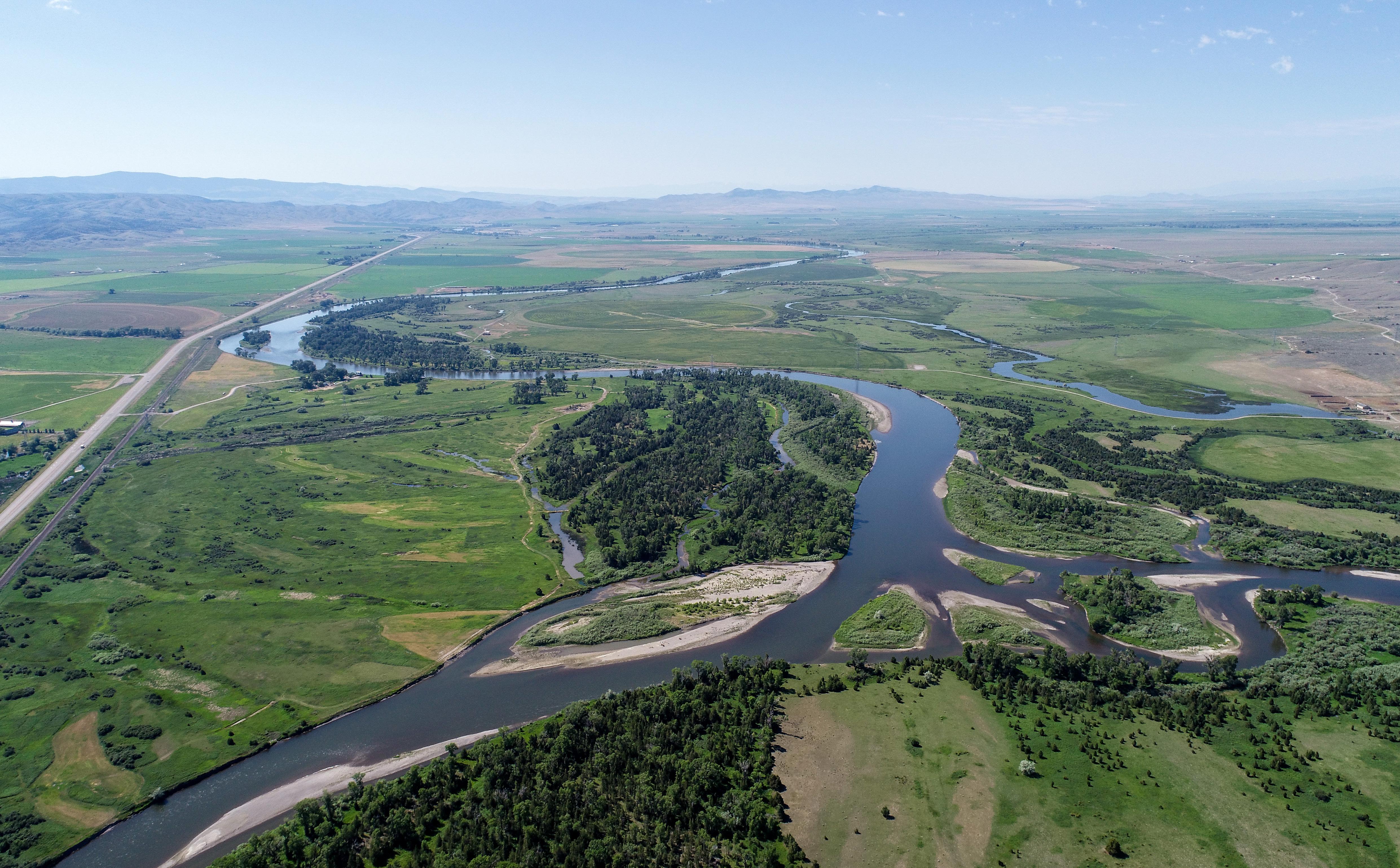
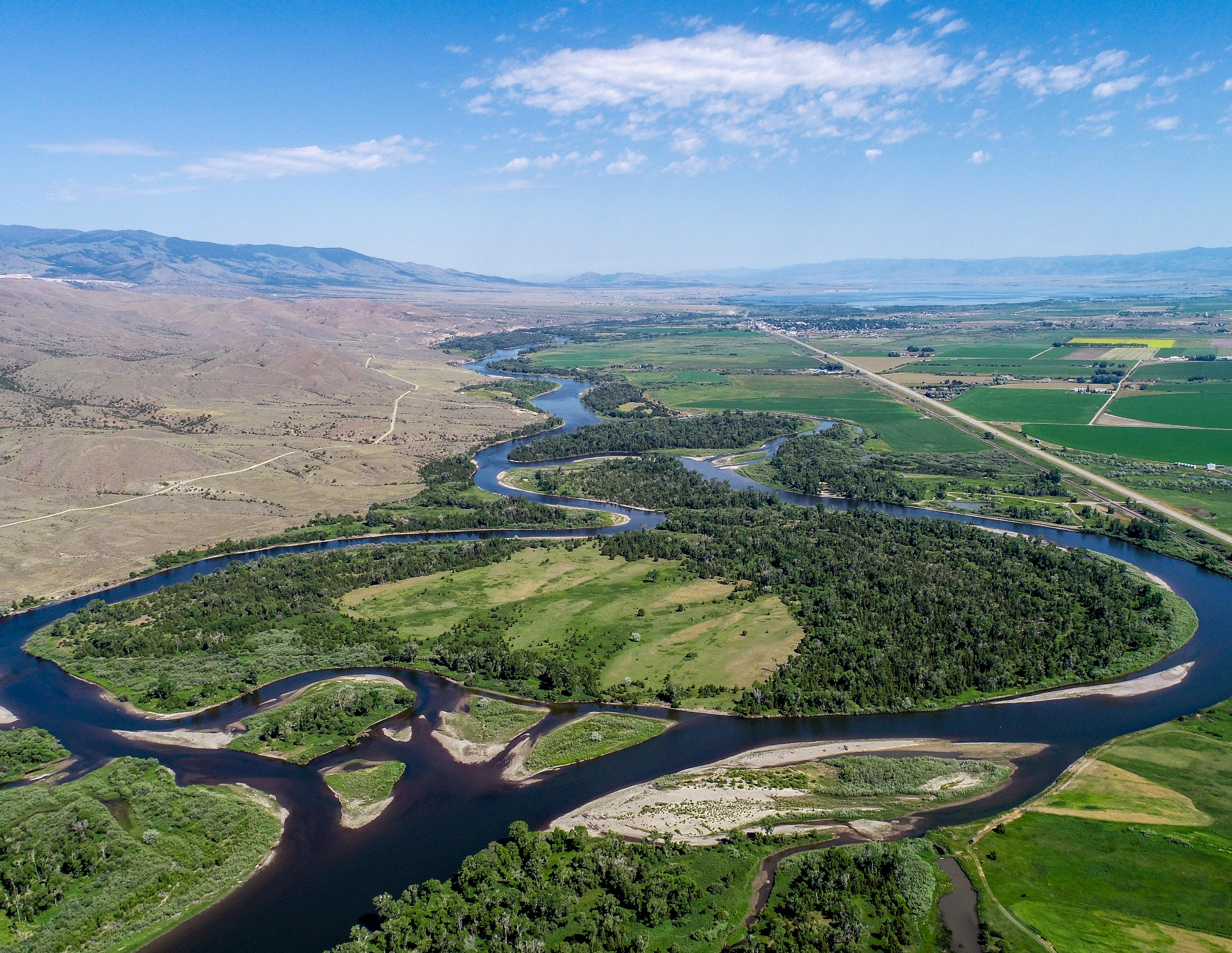
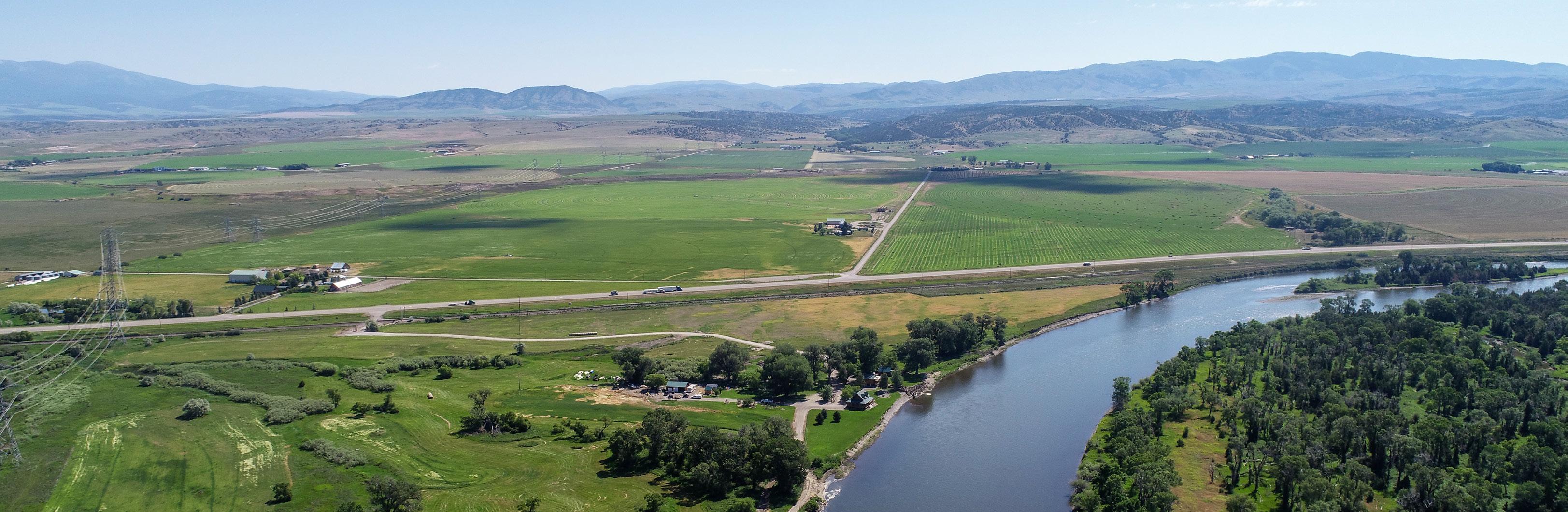
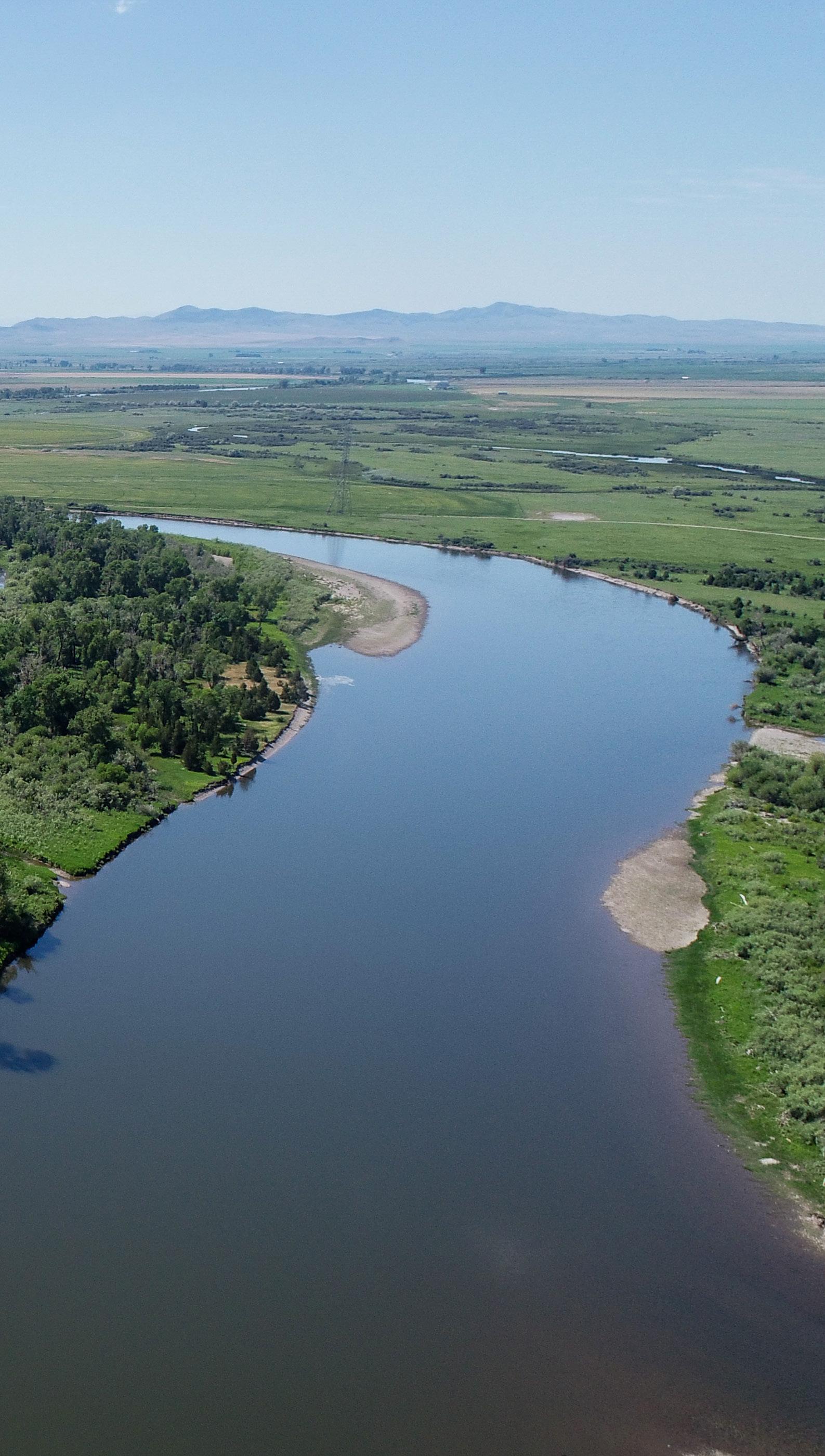
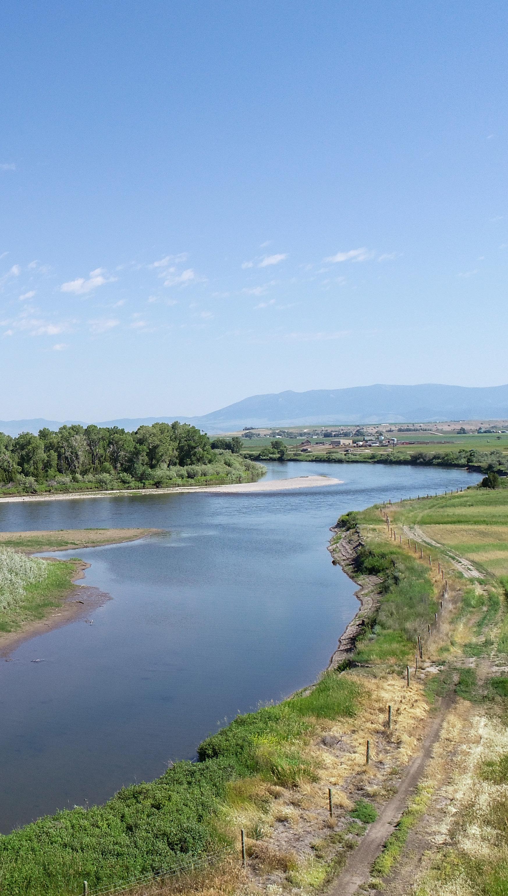
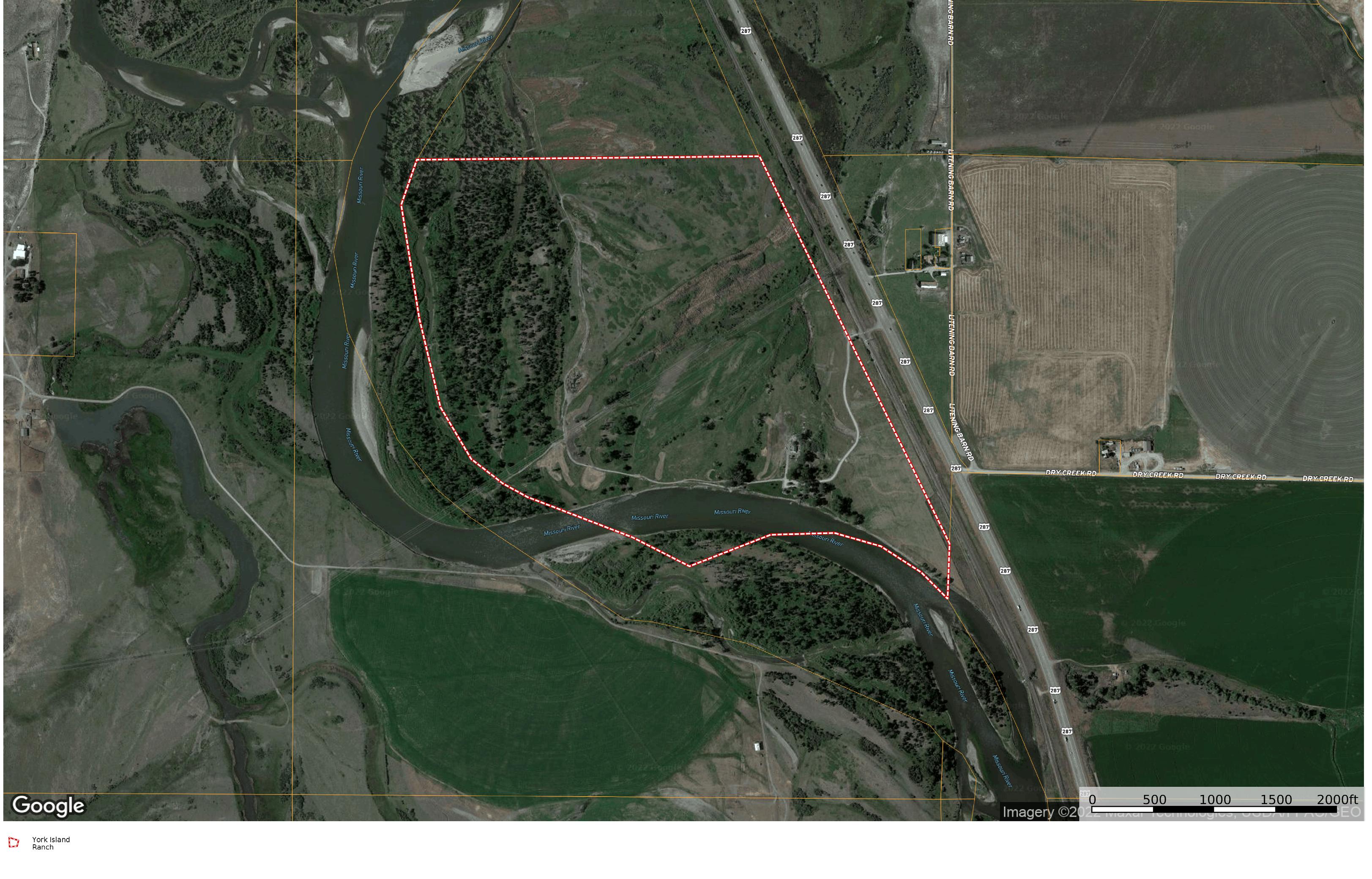
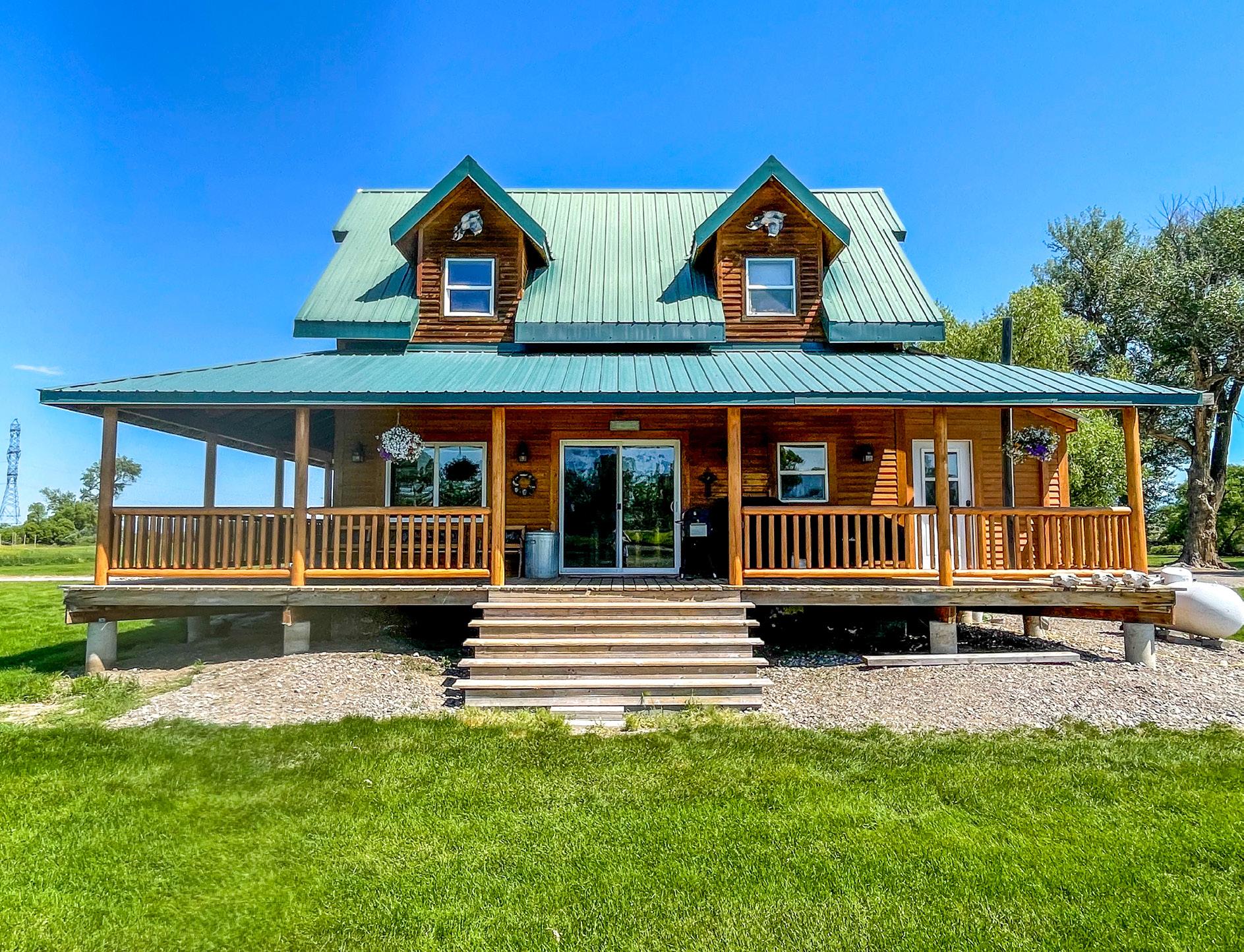
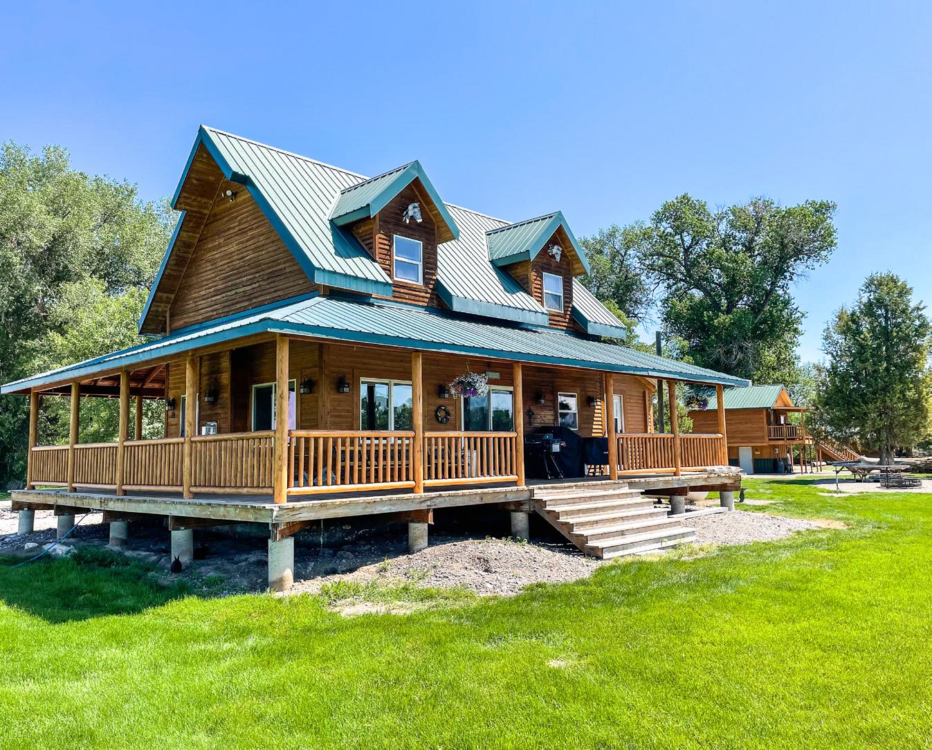
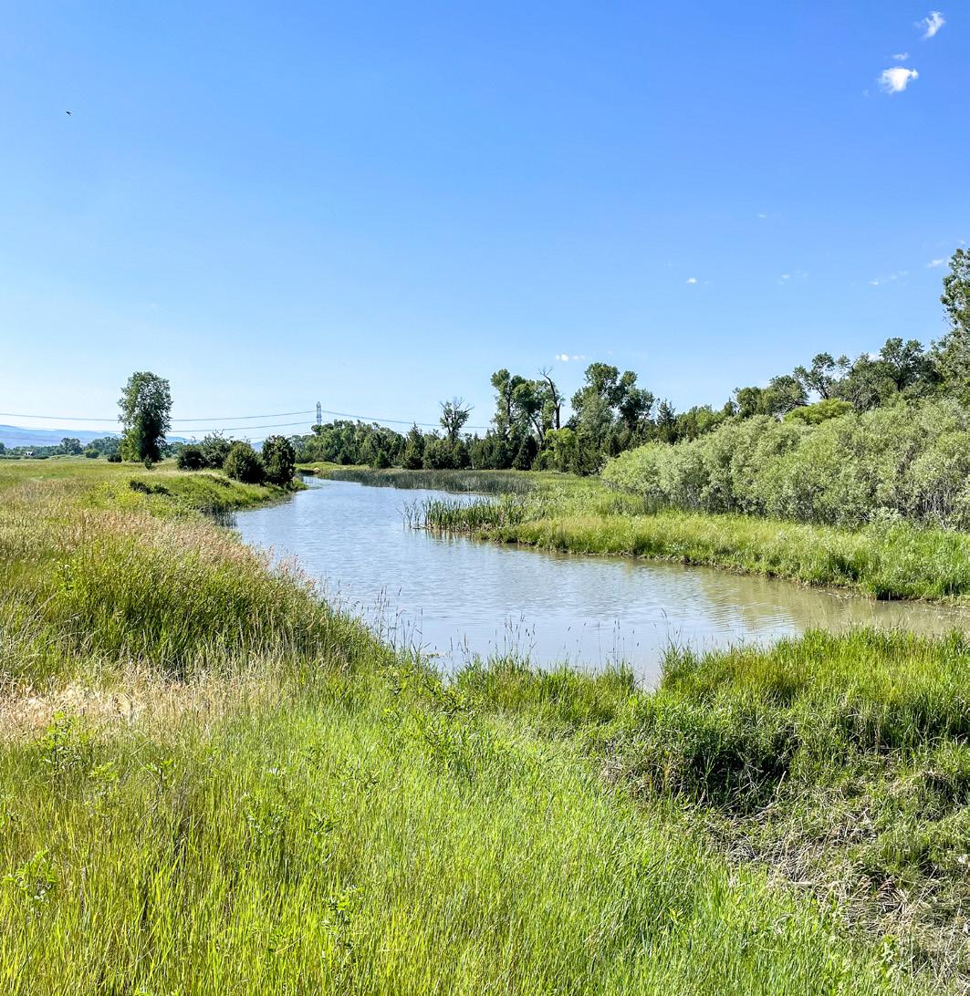
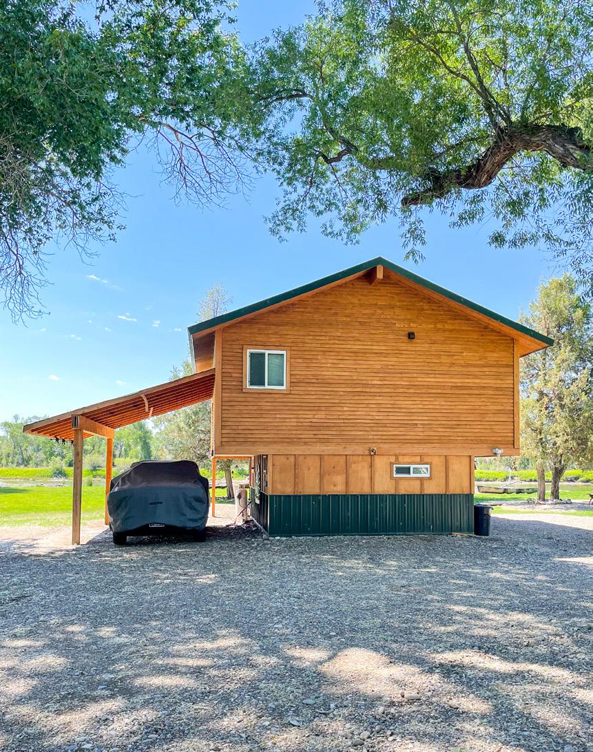
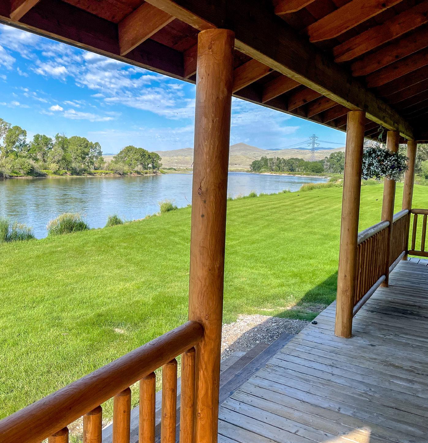
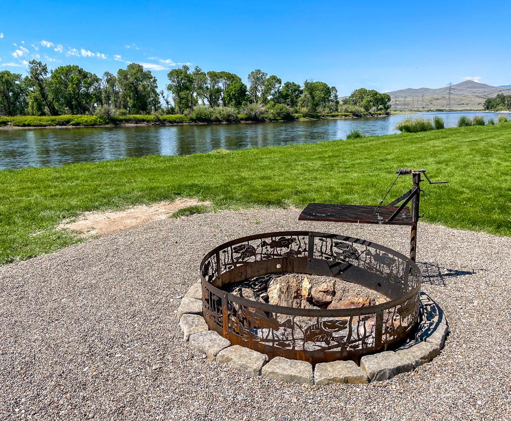
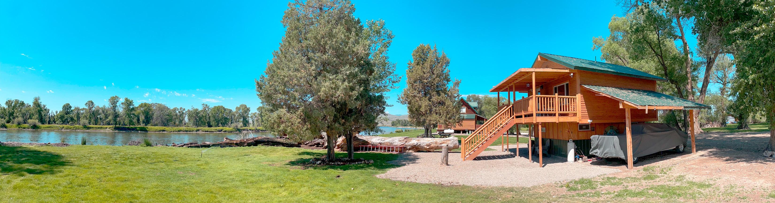
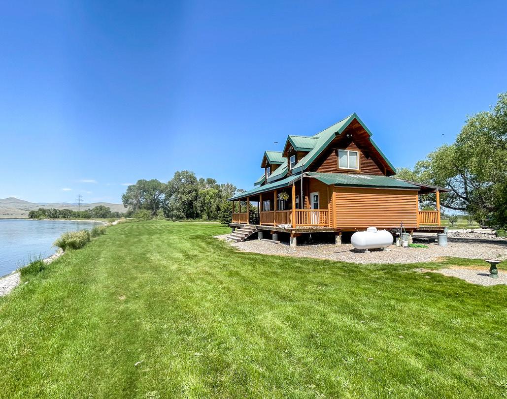
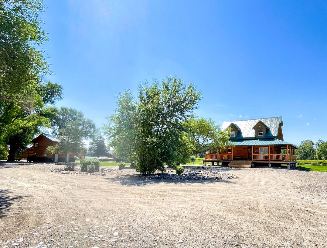
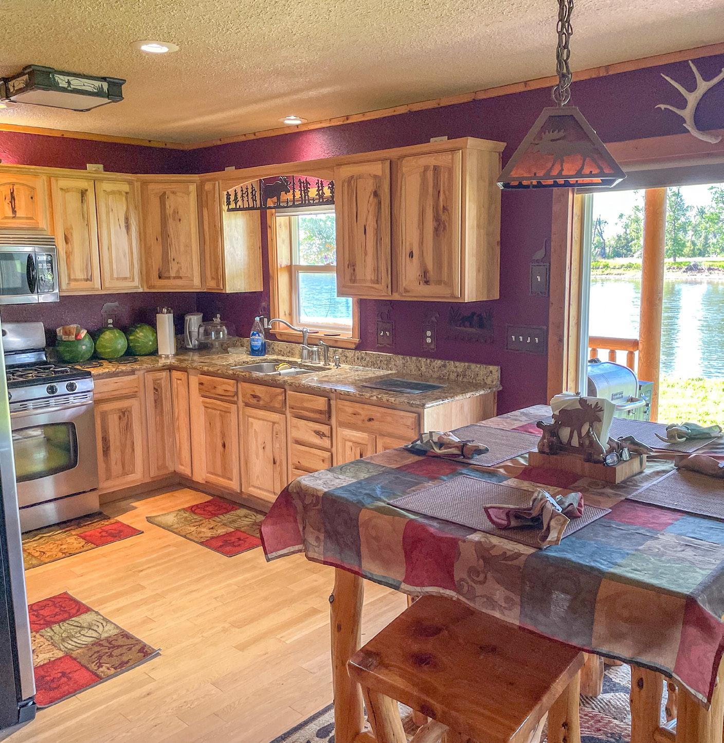
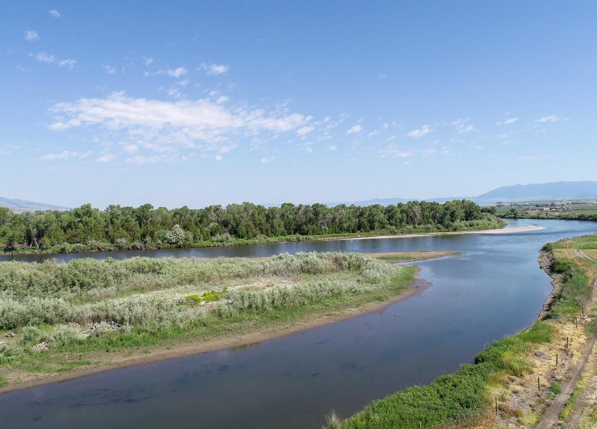
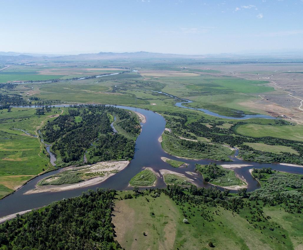
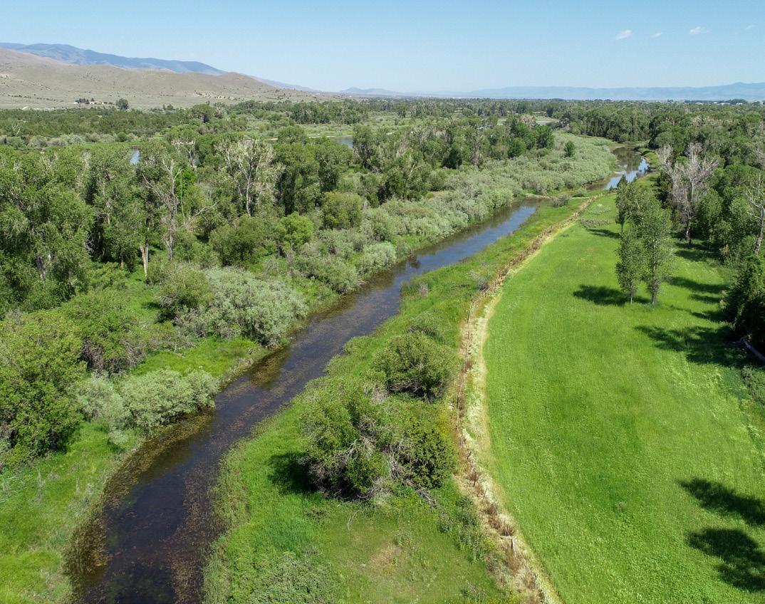
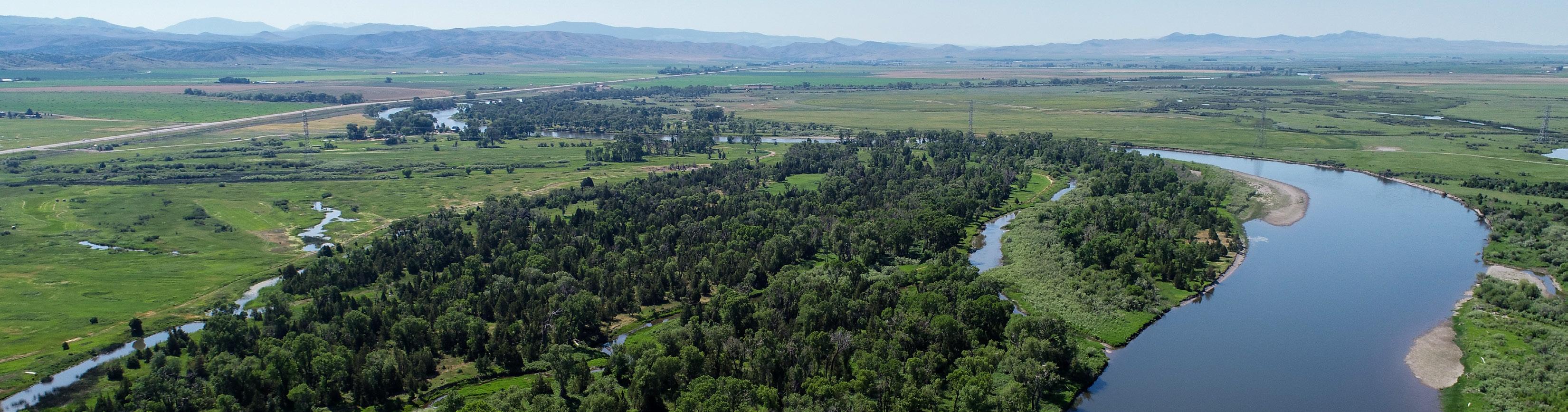
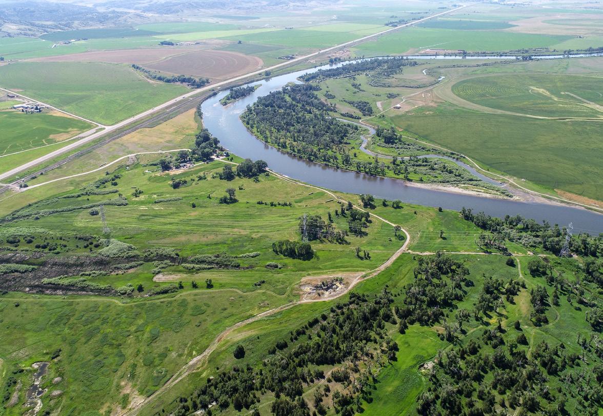
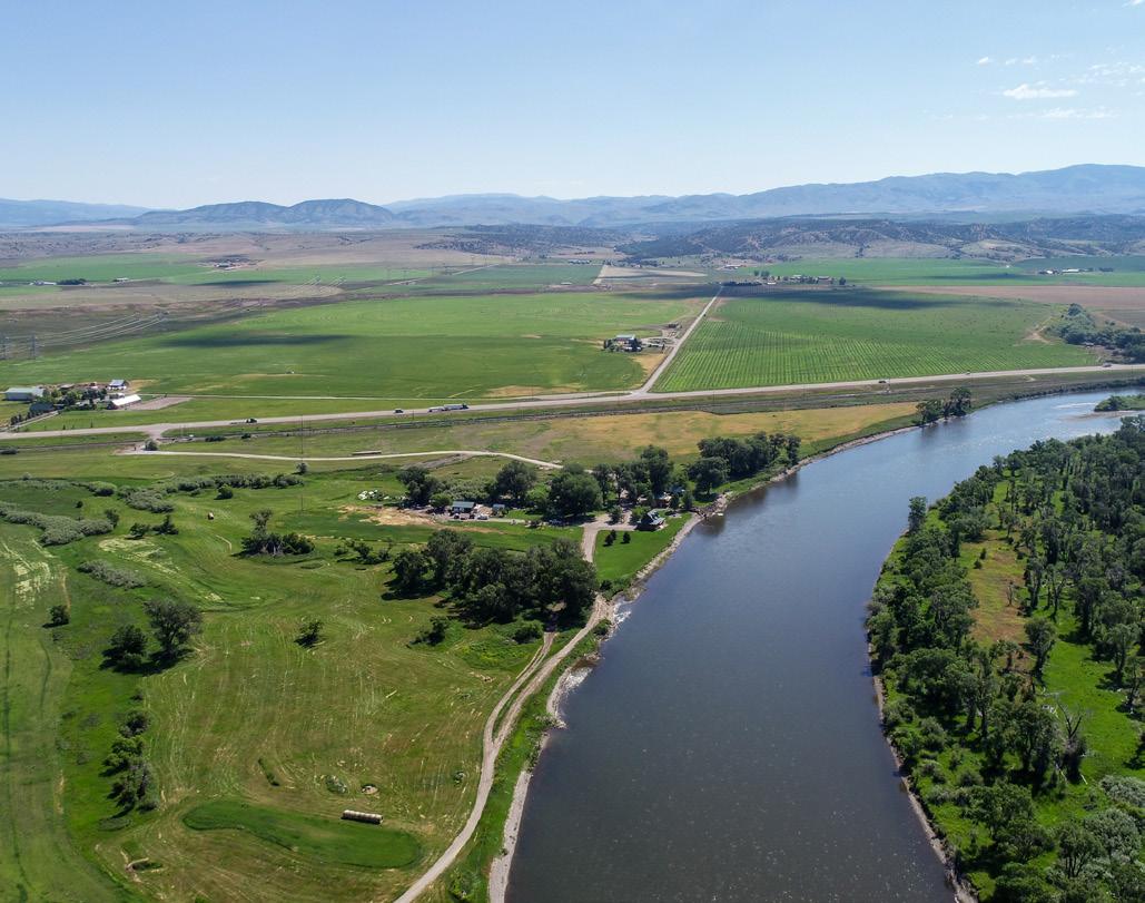
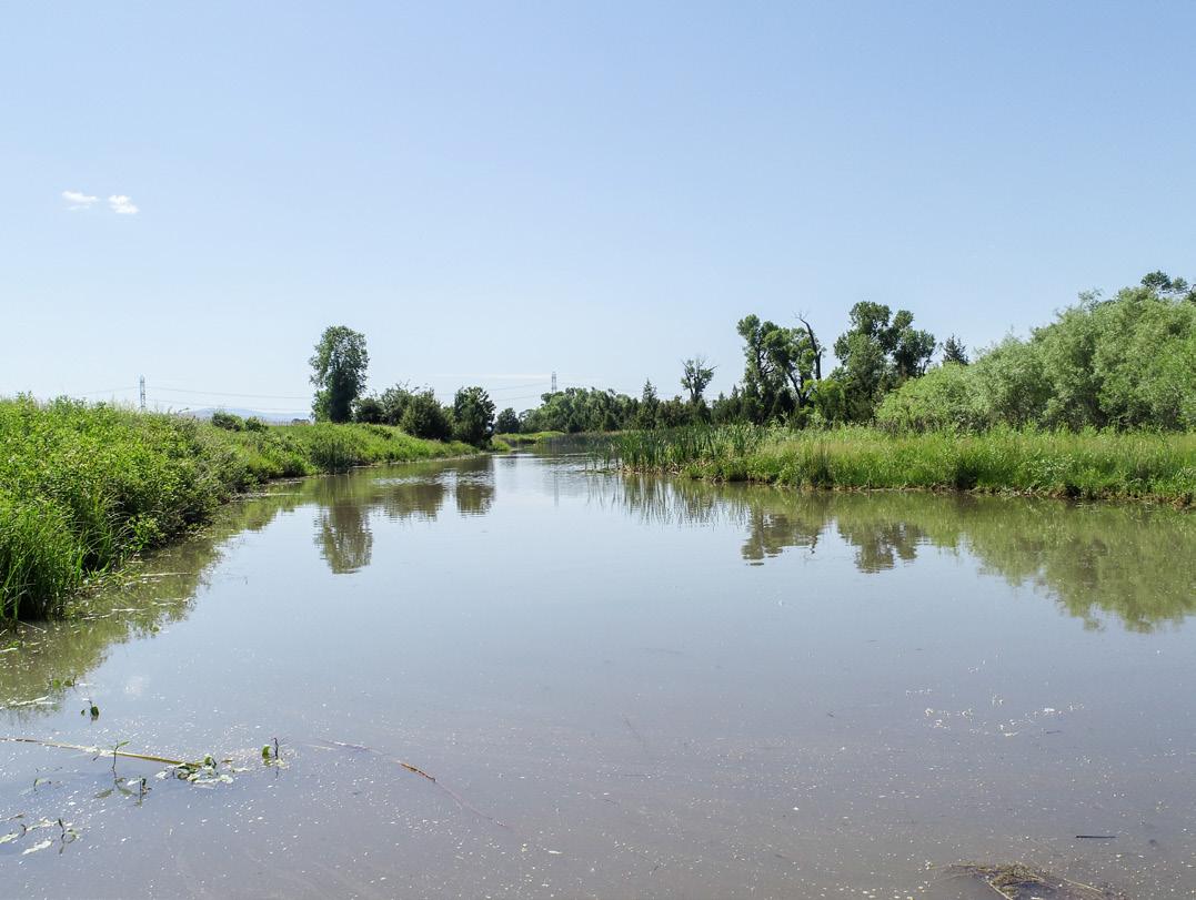
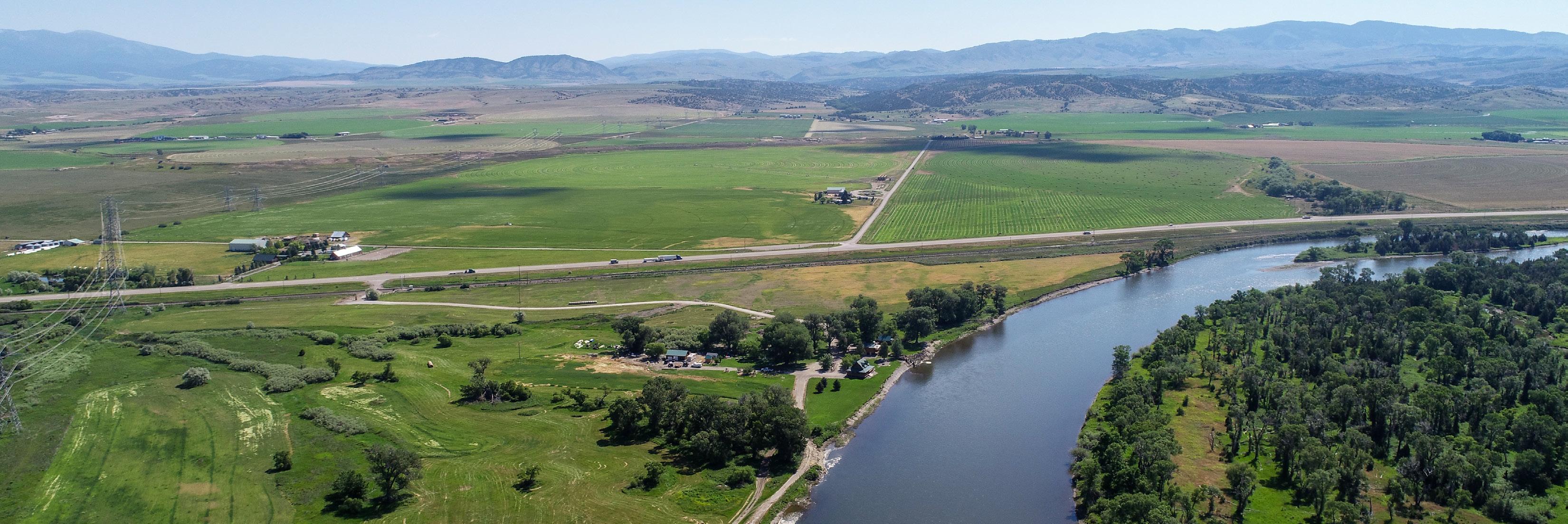
Situated on the banks of the Missouri River, this property possesses complete privacy and is a one-of-a-kind sporting paradise. Boasting approximately a mile and a half of frontage on the mighty Missouri River, York Island Ranch is teeming with wildlife and provides first-class fishing with some of the best Walleye and Rainbow Trout literally out your back door. This property has been managed exclusively for habitat over the past 15 years, in turn creating a sanctuary-like setting for whitetail deer, pheasants, turkeys, and an incredible influx of elk during the fall. The waterfowl hunting opportunities are superb, with multiple ponds, back channels, and food sources connected directly to the river flyway. A comfortable but modest 1 bed, 1 bath owner’s residence and recently completed 2 bed, 1 bath guest cabin round out this tremendous offering less than an hour to Bozeman or Helena and 15 minutes to Townsend and Canyon Ferry Reservoir.


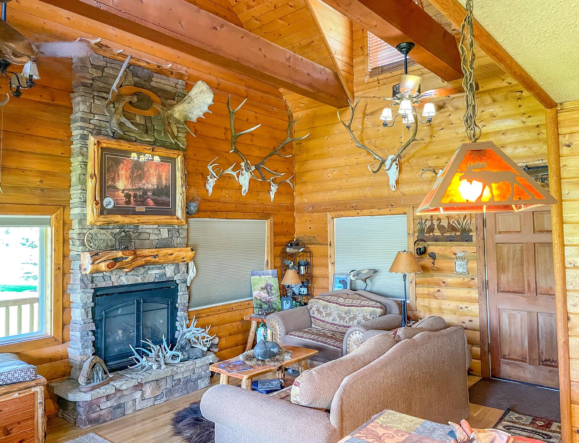
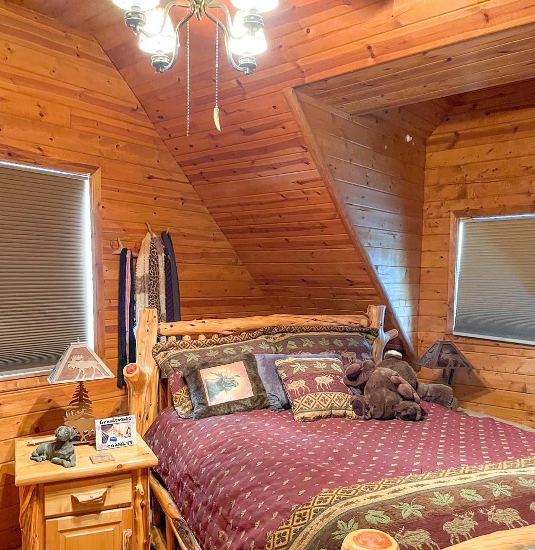
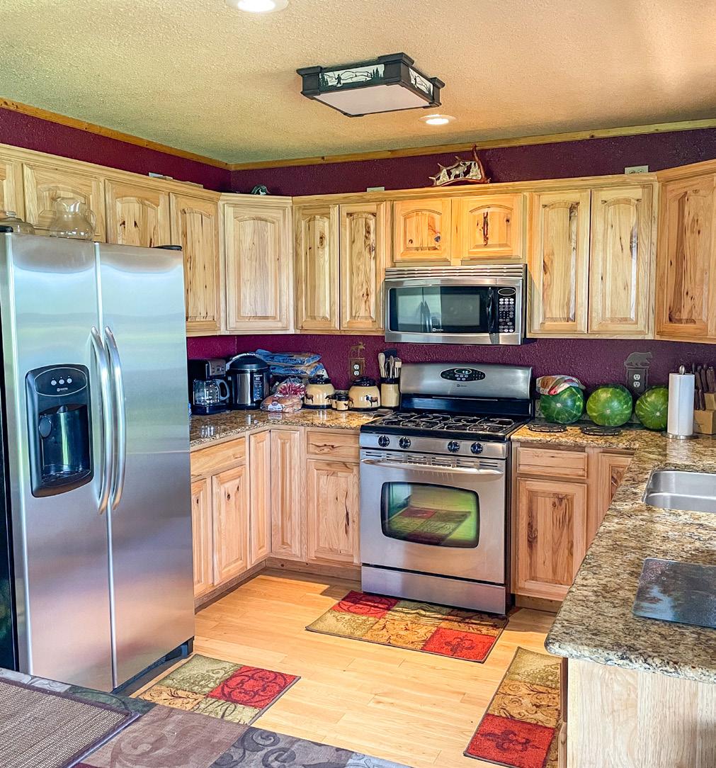
ABOUT YORKS ISLAND RANCH PRICE $2,900,000 MLS 371693 ACREAGE ~225± Acres RIVER FRONTAGE Approximately 1.5 miles PRIMARY HOUSE YEAR BUILT 2006 TOTAL SQUARE FOOTAGE 784sqft TOTAL 1 Bed, 1 Bath MAIN LEVEL FEATURES 560 sqft Kitchen, dining, and living area Floor to ceiling rock fireplace UPPER LEVEL FEATURES 224 sqft One bedroom HEATING/COOLING Central/Forced Air FEATURES 3/4 Wrap around porch
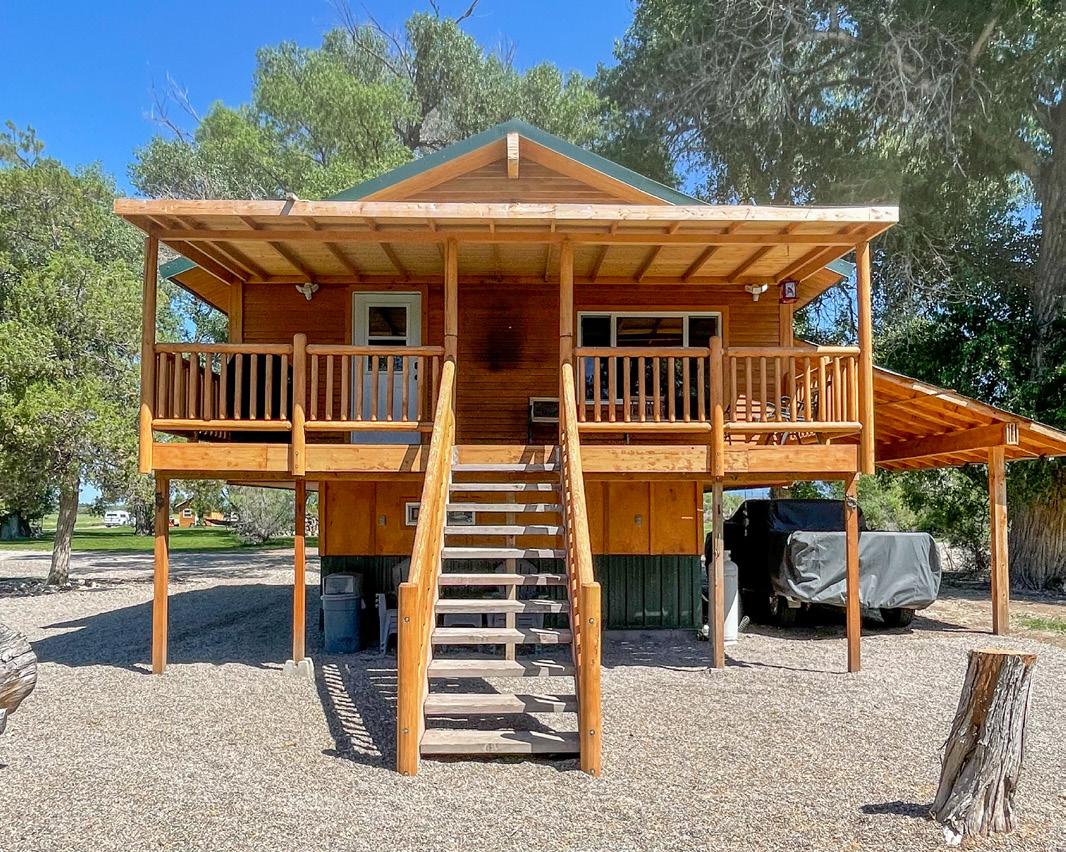
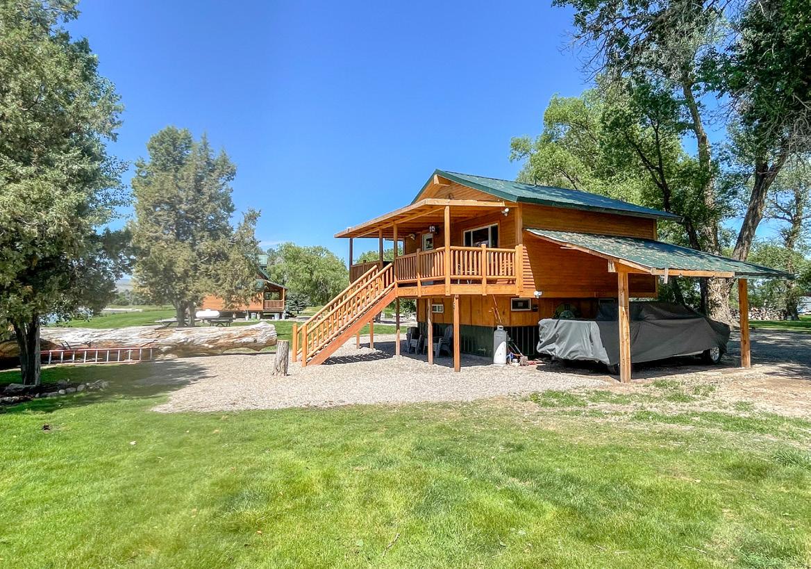
ABOUT YORKS ISLAND RANCH PROPERTY FEATURES Managed for 15 years for trophy elk, whitetail deer, and upland game World-class dog training property Abundance waterfowl First-class fishing 14 miles from Canyon Ferry Reservoir Close proximity to numerous national forest access points 2.5 hours from Yellowstone 3.5 hours from Glacier National Park 63 miles from Great Divide Ski Area (Marysville, MT) 79 miles from Bridger Bowl Ski Area (Bozeman, MT) GUEST CABIN Recently completed additional guest cabin Upper Level – 2 Bed, 1 Bath Lower Level – opportunity to complete/add more finished space TAXES (2021) $1,894 NO COVENANTS
RANCHES.PUREWESTREALESTATE.COM
BROADWATER COUNTY
EXPERIENCE BROADWATER
Townsend is situated approximately 35 miles from Helena, the state capital and 35 miles from the convergence of the Jefferson, Madison, and Gallatin rivers which form the headwaters of the Missouri River.
In 1805, Lewis and Clark passed through on their voyage of discovery, although the first settlers, homesteaders and Civil War veterans in search of gold, did not arrive until the late 1860s. In 1883, a rail stop was established as businesses became established supporting gold mining in the region.
TOWNSEND
Townsend is a city in and the county seat of Broadwater County, Montana.
Nicknamed “the first city on the Missouri River”, Townsend sits nearby the southern tip of Canyon Ferry Lake which is a popular recreation destination and Montana’s third largest body of water.
B roadwater county is perhaps best known as the home of Canyon Ferry Lake, providing essential irrigation to local farms, and serves as a recreation destination for the region, with fishing, boating, swimming, camping, and wildlife viewing opportunities. The boundaries of the county are roughly formed by the Big Belt Mountains to the east and north, the Elkhorn Mountains to the west, and the Horseshoe Hills to the south. In 2020, the population was 6,774. The county was named for Charles Arthur Broadwater, a noted Montana railroad, real estate, and banking magnate.

CANYON FERRY RESERVOIR
GETTING THERE
Bozeman Yellowstone International Airport is just under one hour from the property. Southwest Airlines, Alaska, Allegiant, American Airlines, Delta, Frontier, Jet Blue, and United all fly in and out of Bozeman. As the busiest airport in Montana, Bozeman Yellowstone International Airport offers direct flights to over 20 different cities including: Denver, Salt Lake, Las Vegas, Seattle, Nashville, Boston, New York, Chicago, Dallas, and more.
H elena Regional Airport is also just under one hour from the property. You can find airlines including Delta, Alaska and United flying in and out.
RANCHES.PUREWESTREALESTATE.COM
Covering 35,000+ acres and 76 miles of shoreline, Canyon Ferry is Montana’s third largest body of water. Formed by the building of Canyon Ferry Dam, which was completed in 1954 and has been used for electricity, irrigation, and flood controls since.
C anyon Ferry reservoir provides outdoor enthusiasts with boating, fishing, bow & arrow fishing for Carp, water skiing, parasailing, wind surfing, sailing, ice fishing and ice boat sailing. The area is truly a sportsman paradise with hunting, fishing, hiking, camping, horseback riding, bird & big game watching, ATV & dirt bike areas and trails, snowmobiling, downhill and cross country skiing, virtually out the back door.
opertyRecorPM3:015/2/22,PrintPrdCarddData?Geocode=43149528201010000&year=2022opertyRecoropertyRecorsvc.mt.gov/msl/MTCadastral/PrintPrdCard/GetPrdCar1/4 P r o p e r t y R e c o r d C a r d S u m m a r y P r i m a r y I n f o r m a t i o n P r o p e r t y C a t e g o r y : R P S u b c a t e g o r y : A g r ic u lt u r a l a n d T im b e r P r o p e r t ie s G e o c o d e : 4 3 1 4 9 5 2 8 2 0 1 0 1 0 0 0 0 A s s e s s m e n t C o d e : 0 0 0 7 0 0 0 1 5 9 P r i m a r y O w n e r : P r o p e r t y A d d r e s s : 8 2 7 8 U S H W Y 2 8 7 V A R D E L L M I C K I J T O W N S E N D , M T 5 9 6 4 4 P O B O X 1 3 C O S P a r c e l : T O W N S E N D , M T 5 9 6 4 4 0 0 1 3 N O T E : S e e t h e O w n e r t a b f o r a ll o w n e r in f o r m a t io n C e r t i f i c a t e o f S u r v e y : S u b d i v i s i o n : L e g a l D e s c r i p t i o n : S 2 8 , T 0 6 N , R 0 2 E , L O T S 5 8 9 1 0 ; N E 4 N W 4 ; N E 4 W & S O F R R R / W L a s t M o d i f i e d : 4 / 3 0 / 2 0 2 2 2 : 3 7 : 1 6 P M G e n e r a l P r o p e r t y I n f o r m a t i o n N e i g h b o r h o o d : 2 4 3 0 0 1 P r o p e r t y yT p e : F A R M R F a r m s t e a d R u r a l L i v i n g U n i t s : 1 L e v y D i s t r i c t : 4 3 1 0 5 0 7 O U T Z o n i n g : O w n e r s h i p % : 1 0 0 L i n k e d P r o p e r t y : N o lin k e d p r o p e r t ie s e x is t f o r t h is p r o p e r t y E x e m p t i o n s : N o e x e m p t io n s e x is t f o r t h is p r o p e r t y C o n d o O w n e r s h i p : G e n e r a l : 0 L i m i t e d : 0 P r o p e r t y F a c t o r s T o p o g r a p h y : F r o n t i n g : U t i l i t i e s : P a r k i n g yT p e : A c c e s s : P a r k i n g Q u a n t i t y : L o c a t i o n : P a r k i n g P r o x i m i t y : L a n d S u m m a r y L a n d yT p e A c r e s V a l u e G r a z i n g 2 2 4 0 0 0 0 0 0 0 F a l l o w 0 0 0 0 0 0 0 0 I r r i g a t e d 0 . 0 0 0 0 0 . 0 0 C o n t i n u o u s C r o p 0 0 0 0 0 0 0 0 W i l d H a y 0 0 0 0 0 0 0 0 F a r m s i t e 1 0 0 0 0 0 0 0 R O W 0 . 0 0 0 0 0 . 0 0 N o n Q u a l L a n d 0 0 0 0 0 0 0 0 T o t a l A g L a n d 2 2 5 0 0 0 0 0 0 0 T o t a l F o r e s t L a n d 0 0 0 0 0 0 0 0 T o t a l M a r k e t L a n d 0 0 0 0 0 0 0 0 D e e d I n f o r m a t i o n : D e e d D a t e B o o k P a g e R e c o r d e d D a t e D o c u m e n t N u m b e r D o c u m e n t yT p e 4 / 4 / 2 0 0 6 9 2 8 3 4 2 / 6 / 1 9 9 2 2 2 6 9 7 6 / 1 2 / 1 9 9 0 1 7 3 9 3
opertyRecorPM3:015/2/22,PrintPrdCarddData?Geocode=43149528201010000&year=2022opertyRecoropertyRecorsvc.mt.gov/msl/MTCadastral/PrintPrdCard/GetPrdCar O w n e r s P a r t y # 1 D e f a u l t I n f o r m a t i o n : V A R D E L L M I C K I J P O B O X 1 3 O w n e r s h i p % : 1 0 0 P r i m a r y O w n e r : " Y e s " I n t e r e s t yT p e : C o n v e r s io n L a s t M o d i f i e d : 3 / 1 1 / 2 0 1 1 8 : 5 4 : 1 7 A M O t h e r N a m e s O t h e r A d d r e s s e s N a m e yT p e P E T R O V I S H W I L L I A M J J R L A d d it io n a l L e g a l O w n e r s N o o t h e r a d d r e s s A p p r a i s a l s A p p r a i s a l H i s t o r y T a x Y e a r L a n d V a l u e B u i l d i n g V a l u e T o t a l V a l u e M e t h o d 2 0 2 1 2 3 2 8 0 1 6 9 4 8 0 1 9 2 7 6 0 C O S T 2 0 2 0 2 1 1 8 8 1 4 9 1 9 0 1 7 0 3 7 8 C O S T M a r k e t L a n d M a r k e t L a n d I n f o N o m a r k e t la n d in f o e x is t s f o r t h is p a r c e l D w e l l i n g s E x i s t i n g D w e l l i n g s D w e l l i n g yT p e S t y l e Y e a r B u i l t S F R 0 8 C o n v e n t io n a l 2 0 0 6 D w e l l i n g I n f o r m a t i o n R e s i d e n t i a l yT p e : S F R S t y l e : 0 8 C o n v e n t io n a l Y e a r B u i l t : 2 0 0 6 R o o f M a t e r i a l : 5 M e t a l E f f e c t i v e Y e a r : 0 R o o f yT p e : 3G a b le S t o r y H e i g h t : 1 . 0 A t t i c yT p e : 3 G r a d e : 5 E x t e r i o r W a l l s : 1 F r a m e C l a s s C o d e : 3 1 1 0 E x t e r i o r W a l l F i n i s h : 6 W o o d S id in g o r S h e a t h in g Y e a r R e m o d e l e d : 0 D e g r e e R e m o d e l e d : M o b i l e H o m e D e t a i l s M a n u f a c t u r e r : S e r i a l # : W i d t h : 0 M o d e l : L e n g t h : 0 B a s e m e n t I n f o r m a t i o n F o u n d a t i o n : 2 C o n c r e t e F i n i s h e d A r e a : 0 D a y l i g h t : B a s e m e n t yT p e : 0 N o n e Q u a l i t y : H e a t i n g / C o o l i n g I n f o r m a t i o n yT p e : C e n t r a l S y s t e m yT p e : 5 F o r c e d A ir F u e l yT p e : 3 G a s H e a t e d A r e a : 0 L i v i n g A c c o m o d a t i o n s B e d r o o m s : 1 F u l l B a t h s : 1 A d d l F i x t u r e s : 5 F a m i l y R o o m s : 0 H a l f B a t h s : 0 A d d i t i o n a l I n f o r m a t i o n F i r e p l a c e s : S t a c k s : 0 S t o r i e s : O p e n i n g s : 0 P r e f a b / S t o v e : 1
opertyRecorPM3:015/2/22,PrintPrdCarddData?Geocode=43149528201010000&year=2022opertyRecoropertyRecorsvc.mt.gov/msl/MTCadastral/PrintPrdCard/GetPrdCar3/4 G a r a g e C a p a c i t y : 0 C o s t & D e s i g n : 0 F l a t A d d : 0 % C o m p l e t e : 0 D e s c r i p t i o n : D e s c r i p t i o n : D w e l l i n g A m e n i t i e s V i e w : A c c e s s : A r e a U s e d I n C o s t B a s e m e n t : 0 A d d i t i o n a l F l o o r s : 0 A t t i c : 2 2 4 F i r s t F l o o r : 5 6 0 H a l f S t o r y : 0 U n f i n i s h e d A r e a : 0 S e c o n d F l o o r : 0 S F L A : 7 8 4 D e p r e c i a t i o n I n f o r m a t i o n C D U : P h y s i c a l C o n d i t i o n : V e r y G o o d ( 9 ) U t i l i t y : G o o d ( 8 ) D e s i r a b i l i t y : P r o p e r t y : A v e r a g e ( 7 ) L o c a t i o n : V e r y G o o d ( 9 ) D e p r e c i a t i o n C a l c u l a t i o n A g e : 1 4 P c t G o o d : 0 8 8 R C N L D : 0 A d d i t i o n s / O t h e r F e a t u r e s A d d it io n s L o w e r F i r s t S e c o n d T h i r d A r e a Y e a r C o s t 1 1 P o r c h , F r a m e , O p e n 1 5 2 0 0 0 1 1 P o r c h , F r a m e , O p e n 6 4 0 0 T h e r e a r e n o o t h e r f e a t u r e s f o r t h is d w e llin g O t h e r B u i l d i n g s / I m p r o v e m e n t s O u t b u i l d i n g / Y a r d I m p r o v e m e n t # 1 yT p e : A g D e s c r i p t i o n : R R G 3 G a r a g e , f r a m e , d e t a c h e d , u n f in is h e d Q u a n t i t y : 1 Y e a r B u i l t : 2 0 0 6 G r a d e : 5 C o n d i t i o n : F u n c t i o n a l : C l a s s C o d e : 3 1 1 0 D i m e n s i o n s W i d t h / D i a m e t e r : 2 7 L e n g t h : 3 8 S i z e / A r e a : 1 0 2 6 H e i g h t : B u s h e l s : C i r c u m f e r e n c e : C o m m e r c i a l E x i s t i n g C o m m e r c i a l B u i l d i n g s N o c o m m e r c ia l b u ild in g s e x is t f o r t h is p a r c e l A g / F o r e s t L a n d A g / F o r e s t L a n d I t e m # 1 A c r e yT p e : G G r a z in g I r r i g a t i o n yT p e : C l a s s C o d e : 1 6 0 1 T i m b e r Z o n e : P r o d u c t i v i t y Q u a n t i t y : 0 5 9 8 C o m m o d i t y : G r a z in g F e e U n i t s : A U M / A c r e V a l u a t i o n A c r e s : 8 9 . 5 4 5 P e r A c r e V a l u e : 0 V a l u e : 0 A g / F o r e s t L a n d I t e m # 2 A c r e yT p e : G G r a z in g I r r i g a t i o n yT p e : C l a s s C o d e : 1 6 0 1 T i m b e r Z o n e : P r o d u c t i v i t y Q u a n t i t y : 0 6 8 2 C o m m o d i t y : G r a z in g F e e
opertyRecorPM3:015/2/22,PrintPrdCarddData?Geocode=43149528201010000&year=2022opertyRecoropertyRecorsvc.mt.gov/msl/MTCadastral/PrintPrdCard/GetPrdCar U n i t s : A U M / A c r e V a l u a t i o n A c r e s : 2 1 2 9 P e r A c r e V a l u e : 0 V a l u e : 0 A g / F o r e s t L a n d I t e m # 3 A c r e yT p e : F S A F a r m s it e o n a g r ic u lt u r a l la n d I r r i g a t i o n yT p e : C l a s s C o d e : 2 0 0 1 T i m b e r Z o n e : P r o d u c t i v i t y Q u a n t i t y : 0 C o m m o d i t y : N / A U n i t s : V a l u a t i o n A c r e s : 1 P e r A c r e V a l u e : 0 V a l u e : 0 A g / F o r e s t L a n d I t e m # 4 A c r e yT p e : G G r a z in g I r r i g a t i o n yT p e : C l a s s C o d e : 1 6 0 1 T i m b e r Z o n e : P r o d u c t i v i t y Q u a n t i t y : 0 . 0 4 3 C o m m o d i t y : G r a z in g F e e U n i t s : A U M / A c r e V a l u a t i o n A c r e s : 4 9 8 4 9 P e r A c r e V a l u e : 0 V a l u e : 0 A g / F o r e s t L a n d I t e m # 5 A c r e yT p e : GG r a z in g I r r i g a t i o n yT p e : C l a s s C o d e : 1 6 0 1 T i m b e r Z o n e : P r o d u c t i v i t y Q u a n t i t y : 0 1 7 4 C o m m o d i t y : G r a z in g F e e U n i t s : A U M / A c r e V a l u a t i o n A c r e s : 6 3 3 1 6 P e r A c r e V a l u e : 0 V a l u e : 0
OptionsOtherREPORTLOGWELLANAMONTwellMontanalicensedaofactivitiesthereportslogwellThisdriller,servesastheofficialwaterofamountthedescribesandcasing,andboreholethewithindoneworkofrecordWGroundtheofcontentsthefromelectronicallycompiledisreportThisencountered.aterwelltheisrightswaterAcquiringsite.thisfordatabase(GWIC)CenterInformationreport.thisoffilingthebyaccomplishedNOTisandresponsibilityowner's menutoReturnAtlasDigitalLibraryStateinsitethisPlotMapsGoogleinsitethisPlotAM)10:50:37(8/8/2006logwellscannediewV PETROVISH,Name:SiteBILLANDMICKI227648Id:GWICOwner(s)ellW1:Section(MAIL)MICKIANDBILLPETROVISH,1)RDCOACHOLD12050[05/18/2006]59752MTFORKSTHREELocation2:SectionT o w n s h i p R a n g e S e c t i o n Q u a r t e r S e c t i o n s 0 6 N 0 2 E 2 1 S E ¼ S W ¼ C o u n t y G e o c o d e B R O A D W A T E R L a t i t u d e L o n g i t u d e G e o m e t h o d D a t u m 4 6 2 5 5 4 1 3 6 2 5 5 5 1 1 1 4 8 6 2 2 0 2 1 9 T R S S E C N A D 8 3 G r o u n d S u r f a c e A l t i t u d e G r o u n d S u r f a c e M e t h o d D a t u m D a t e A d d i t i o n B l o c k L o t WofUseProposed3:SectionaterD O M E S T I C ( 1 )WofypeT4:SectionorkD r i l l i n g M e t h o d : R O T A R Y S t a t u s : N E W W E L LDateCompletionellW5:SectionD a t e w e l l c o m p l e t e d : T h u r s d a y , M a y 1 8 , 2 0 0 6 W6:SectionellConstructionDetailsB o r e h o l e d i m e n s i o n s F r o m T o D i a m e t e r 0 1 8 8 1 8 6 0 6 C a s i n g F r o m T o D i a m e t e r W a l l T h i c k n e s s P r e s s u r e R a t i n g J o i n t yT p e 2 6 0 6 0 2 5 0 W E L D E D S T E E L C o m p l e t i o n ( P e r f / S c r e e n ) F r o m T o D i a m e t e r # o f O p e n i n g s S i z e o f O p e n i n g s D e s c r i p t i o n 6 0 6 0 6 O P E N B O T T O M A n n u l a r S p a c e ( S e a l / G r o u t / P a c k e r ) F r o m T o D e s c r i p t i o n C o n t . F e d ? 0 0 B E N T O N I T E Y W7:SectionellTestData60Depth:otalT4Level:aterWStaticemperature:TaterWestTAir *atsetstemdrillwithgpm5060feetfor1hours.recoveryofimeT0.33hours.levelwaterRecovery4feet.levelwaterPumpingfeet.* uniformasbeshallratedischargethetestwelltheDuringasyieldsustainablethebenotmayormayrateThispossible.ofthewell.ofreservoirtheincludenotdoesyieldSustainablethewellcasing.Remarks8:SectionLogellW9:SectionSourceGeologicUnassignedF r o m T o D e s c r i p t i o n 0 2 T O P S O I L 2 5 B L A C K S I L T 5 1 3 S A N D A N D G R A V E L 1 3 2 3 S A N D 2 3 2 9 S I L T Y T A N C L A Y 2 9 3 4 S A N D 3 4 5 1 S A N D A N D G R A V E L 5 1 5 4 S A N D Y S I L T 5 4 5 6 S A N D 5 6 6 0 S A N D A N D G R A V E L CertificationDrillerlogwellthisinreportedandperformedworkAllisincompliancewithbestthetotrueisreportThisstandards.constructionwellMontanatheknowledge.myofN a m e : M A R K M I L L E R C o m p a n y : A 1 0 D R I L L I N G L i c e n s e N o : W W C 6 1 1 D a t e C o m p l e t e d : 5 / 1 8 / 2 0 0 6
OptionsOtherREPORTLOGWELLANAMONTwellMontanalicensedaofactivitiesthereportslogwellThisdriller,servesastheofficialwaterofamountthedescribesandcasing,andboreholethewithindoneworkofrecordWGroundtheofcontentsthefromelectronicallycompiledisreportThisencountered.aterwelltheisrightswaterAcquiringsite.thisfordatabase(GWIC)CenterInformationreport.thisoffilingthebyaccomplishedNOTisandresponsibilityowner's menutoReturnAtlasDigitalLibraryStateinsitethisPlotMapsGoogleinsitethisPlotAM)10:50:22(8/8/2006logwellscannediewV PETROVISH,Name:SiteBILLANDMICKI227649Id:GWICOwner(s)ellW1:Section(MAIL)MICKIANDBILLOVISH,PET1)RDCOACHOLD12050[05/19/2006]59752MTFORKSTHREELocation2:SectionT o w n s h i p R a n g e S e c t i o n Q u a r t e r S e c t i o n s 0 6 N 0 2 E 2 1 S E ¼ S W ¼ C o u n t y G e o c o d e B R O A D W A T E R L a t i t u d e L o n g i t u d e G e o m e t h o d D a t u m 4 6 2 5 5 4 1 3 6 2 5 5 5 1 1 1 4 8 6 2 2 0 2 1 9 T R S S E C N A D 8 3 G r o u n d S u r f a c e A l t i t u d e G r o u n d S u r f a c e M e t h o d D a t u m D a t e A d d i t i o n B l o c k L o t WofUseProposed3:SectionaterD O M E S T I C ( 1 )WofypeT4:SectionorkD r i l l i n g M e t h o d : R O T A R Y S t a t u s : N E W W E L LDateCompletionellW5:SectionD a t e w e l l c o m p l e t e d : F r i d a y , M a y 1 9 , 2 0 0 6W6:SectionellConstructionDetailsB o r e h o l e d i m e n s i o n s F r o m T o D i a m e t e r 0 1 8 8 1 8 6 0 6 C a s i n g F r o m T o D i a m e t e r W a l l T h i c k n e s s P r e s s u r e R a t i n g J o i n t yT p e 2 6 0 6 0 2 5 0 W E L D E D S T E E L C o m p l e t i o n ( P e r f / S c r e e n ) F r o m T o D i a m e t e r # o f O p e n i n g s S i z e o f O p e n i n g s D e s c r i p t i o n 6 0 6 0 6 O P E N B O T T O M A n n u l a r S p a c e ( S e a l / G r o u t / P a c k e r ) F r o m T o D e s c r i p t i o n C o n t F e d ? 0 0 B E N T O N I T E Y W7:SectionellTestData60Depth:otalT5Level:aterWStaticemperature:TaterWestTAir *atsetstemdrillwithgpm5060feetfor1hours.recoveryofimeT0.33hours.levelwaterRecovery5feet.levelwaterPumpingfeet.* uniformasbeshallratedischargethetestwelltheDuringasyieldsustainablethebenotmayormayrateThispossible.ofthewell.ofreservoirtheincludenotdoesyieldSustainablethewellcasing.Remarks8:SectionLogellW9:SectionSourceGeologicUnassignedF r o m T o D e s c r i p t i o n 0 2 T O P S O I L 2 1 1 B L A C K S I L T 1 1 2 6 S A N D 2 6 3 2 S I L T Y G R A Y C L A Y 3 2 3 6 S A N D 3 6 4 6 S A N D A N D G R A V E L 4 6 4 9 S A N D S I L T 4 9 5 4 S A N D 5 4 6 0 S A N D A N D G R A V E L CertificationDrillerlogwellthisinreportedandperformedworkAllisincompliancewithbestthetotrueisreportThisstandards.constructionwellMontanatheknowledge.myofN a m e : M A R K M I L L E R C o m p a n y : A 1 0 D R I L L I N G L i c e n s e N o : W W C 6 1 1 D a t e C o m p l e t e d : 5 / 1 9 / 2 0 0 6
PM3:005/2/22,Searchopyear=2021&Histyeadl.php?customer_id=3081&ntax_id=0007000159&xdate=MDUvMDIvMjAyMg==&pr.mtcounty.com/bmsrhttps://wwwdl/bmsr1/1 /2/050e:atD22p5:3:030e:miT1m yuCoatadorBwerntT,anFasselMirksreasureryaado551Brw 5000000:axTID719pyTe:Real dAddaneamNressOCKIMELLDARVIJPETRVISHJJAMLLIWIR3OPOBX130-065OTWNSENDMT9441 gyypoPrertTaxQuerTWRaneSCDescriptionSE4;/2E/060N21Geo1495-21-2-04-01-0000LOTS2-5-6W&SOF;/2E/0/RRRW06N28Geo1495-28-2-01-01-0000LOTS5-8-9-10N;W4NE4NE4W&SOFRRR/W |CountyBroadwaterDetailyaenaeDaxaeDa.tnIRYtTtTxAmtPltInterestTotalAmt/2/3/2/1daiP2112611101935.9118.734.10 ,8194.62 /2/3/2/1daiP2112610512935.880.000.00/2/3/2/00daiP212901100833.6216.692.06 ,6185.98 /2/3/2/00daiP212900601833.610.000.00/1/0/1/1daiP1912391229740.2114.792.23 ,5126.62 /2/0/2/180daiP19100610740.2014.7914.40/1/3/1/38daiP111081108713.190.000.00 ,4126.34 /1/3/1/38daiP105190519713.150.000.00/1/3/1/2daiP1711971107721.940.000.00 ,4173.71 /1/3/1/180daiP17780518721.9114.4415.42/1/0/1/16daiP112261256619.5412.401.18 ,2152.64 /1/3/1/16daiP112260517619.520.000.00/1/3/1/3305daiP1061105655.9313.1221.72 ,3146.67 /3305daiP10/1606/30/16655.900.000.00/1/0/1/0daiP1412141214648.200.000.00 ,2196.38 /1/0/1/0daiP1412140615648.180.000.00/1/3/1/0603daiP1241103589.2211.7928.25 ,2130.60 /1/3/1/0603daiP1240514589.2211.790.33/1/3/1/3daiP1211021102657.400.000.00 ,3114.79 /1/3/1/3daiP1211020513657.390.000.00/1/3/1/0daiP1111811101634.060.000.00 ,2168.11 /1/3/1/0daiP1111810512634.050.000.00ggyp©Coriht2022.AllRihtsReserved
20222,MayPage1of1CLAIMOFSTATEMENT3014735641I Number:RightWaterUse:ofPlaceRgeTwpSecQtrLotGovtIDSecCountyAcres2128 6N6N 2E2E BROADWATERBROADWATER NWSENWNWNWNW 12 Date:Priority 194931,DECEMBER Rate:FlowMaximum Owners: JRPETROVISHJWILLIAM13BOXPO59644-0013MTTOWNSEND, Right:HistoricalofType USE MONTANAOFSTATECONSERVATIONANDRESOURCESNATURALOFDEPARTMENT59620-1601MONTANAHELENA,201601P.O.BOXAVENUE9TH1424ABSTRACTGENERAL Remarks: Version: RIGHTORIGINAL--1 AbstractGeneral3014735641IUSETHISBECAUSEDECREEDBEENNOTHASRATEFLOWSPECIFICAAFROMORSOURCE,THEFROMDIRECTLYDRINKINGSTOCKOFCONSISTSAMOUNTMINIMUMTHETOLIMITEDISRATEFLOWTHESYSTEM.DITCHPURPOSE.THISSUSTAINTONECESSARYHISTORICALLYFORUSEDCONSUMPTIVELYWATEROFAMOUNTTHEINCLUDESRIGHTTHISPERDAYPERGALLONS30OFRATETHEATPURPOSESWATERINGSTOCKCARRYINGREASONABLEONBASEDBESHALLUNITSANIMALUNIT.ANIMALWATERTHISBYSERVICEDAREATHEOFUSEHISTORICALANDCAPACITYSOURCE. Volume:Maximum WATERSURFACE Type:Source Name:Source RIVERMISSOURISPRING,RgeTwpSecQtrLotGovtIDSecCounty Diversion:ofMeansandDiversionofPointSOURCEFROMDIRECTLIVESTOCKSOURCEFROMDIRECTLIVESTOCK Means:DiversionMeans:Diversion Diversion:ofPeriodDiversion:ofPeriod 31DECEMBERTO1JANUARY31DECEMBERTO1JANUARY 12 2128 2E2E 6N6N NWSENWNWNWNW BROADWATERBROADWATER (use):Purpose STOCK Use:ofPeriod 31DECEMBERto1JANUARY Geocodes/Valid: Y-43-1495-28-2-01-01-0000Y-43-1495-21-2-04-01-0000ISSUED.DECREEBASINTHEININCLUDEDNOTWASNUMBERCLAIMTHISPROPERTYTHE07/09/2020,OFASRECORDS,OWNERSHIPPROPERTYCADASTRALTOACCORDINGWILLIAMANDVARDELLJ.MICKIBYOWNEDBETOAPPEARSUSEDISRIGHTWATERTHISWHICHONJR.PETROVISHJ.INFORMATIONFROMREFINEDBENOTCOULDDESCRIPTIONLANDLEGALDIVERSIONOFPOINTTHEFILE.CLAIMTHEIN Date:PriorityEnforceable 194931,DECEMBER Status:Version ACTIVE
20222,MayPage1of2CERTIFICATEWATERGROUND3002532341I Number:RightWaterUse:ofPlaceUse:ofPlaceUse:ofPlace IDIDID LotGovtLotGovtLotGovt SecQtrSecQtrSecQtr SecSecSec TwpTwpTwp RgeRgeRge CountyCountyCounty AcresAcresAcres 212121 6N6N6N 2E2E2E BROADWATERBROADWATERBROADWATER SESWSESWSESW 111 Date:Priority A.M.11:56at200617,NOVEMBER Rate:FlowMaximum Owners: JRPETROVISHJWILLIAM13BOXPO59644-0013MTTOWNSEND, MONTANAOFSTATECONSERVATIONANDRESOURCESNATURALOFDEPARTMENT59620-1601MONTANAHELENA,201601P.O.BOXAVENUE9TH1424ABSTRACTGENERALVersion: RIGHTORIGINAL--1 AbstractGeneral3002532341IGALLONS35TOUPUSEDAMOUNTACTUALTHETOLIMITEDISRIGHTTHISMINUTE.PERACRE-FEET.10TOUPUSEDAMOUNTACTUALTHETOLIMITEDISRIGHTTHIS Volume:Maximum GROUNDWATER Type:Source Name:Source GROUNDWATERRgeTwpSecQtrLotGovtIDSecCounty Diversion:ofMeansandDiversionofPointWELL Means:DiversionDiameter:Casing INCHES6.00 Level:WaterStatic FEET4.00 Depth:Well FEET60.00 Diversion:ofPeriod 31DECEMBERTO1JANUARY BROADWATERSESW6N2E211 (use):Purpose DOMESTICGARDENANDLAWNIRRIGATIONSTOCK Households:Volume:Volume:Volume:Volume: (Use):Purpose(Use):Purpose(Use):Purpose(Use):Purpose DOMESTICGARDENANDLAWNIRRIGATIONSTOCK Use:ofPeriodUse:ofPeriodUse:ofPeriodUse:ofPeriod 31DECEMBERto1JANUARY31OCTOBERto1APRIL31OCTOBERto1APRIL31DECEMBERto1JANUARY Date:PriorityEnforceable A.M.11:56at200617,NOVEMBER Status:Version ACTIVE
RANCHES.PUREWESTREALESTATE.COM 20222,MayPage1of2CERTIFICATEWATERGROUND3002532441I Number:RightWaterUse:ofPlaceUse:ofPlaceUse:ofPlace IDIDID LotGovtLotGovtLotGovt SecQtrSecQtrSecQtr SecSecSec TwpTwpTwp RgeRgeRge CountyCountyCounty AcresAcresAcres 212121 6N6N6N 2E2E2E BROADWATERBROADWATERBROADWATER SESWSESWSESW 111 Date:Priority A.M.11:55at200617,NOVEMBER Rate:FlowMaximum Owners: JRPETROVISHJWILLIAM13BOXPO59644-0013MTTOWNSEND, MONTANAOFSTATECONSERVATIONANDRESOURCESNATURALOFDEPARTMENT59620-1601MONTANAHELENA,201601P.O.BOXAVENUE9TH1424ABSTRACTGENERALVersion: RIGHTORIGINAL--1 AbstractGeneral3002532441IGALLONS35TOUPUSEDAMOUNTACTUALTHETOLIMITEDISRIGHTTHISMINUTE.PERACRE-FEET.10TOUPUSEDAMOUNTACTUALTHETOLIMITEDISRIGHTTHIS Volume:Maximum GROUNDWATER Type:Source Name:Source GROUNDWATERRgeTwpSecQtrLotGovtIDSecCounty Diversion:ofMeansandDiversionofPointWELL Means:DiversionDiameter:Casing INCHES6.00 Level:WaterStatic FEET5.00 Depth:Well FEET60.00 Diversion:ofPeriod 31DECEMBERTO1JANUARY BROADWATERSESW6N2E211 (use):Purpose DOMESTICGARDENANDLAWNIRRIGATIONSTOCK Households:Volume:Volume:Volume:Volume: (Use):Purpose(Use):Purpose(Use):Purpose(Use):Purpose DOMESTICGARDENANDLAWNIRRIGATIONSTOCK Use:ofPeriodUse:ofPeriodUse:ofPeriodUse:ofPeriod 31DECEMBERto1JANUARY31OCTOBERto1APRIL31OCTOBERto1APRIL31DECEMBERto1JANUARY Date:PriorityEnforceable A.M.11:55at200617,NOVEMBER Status:Version ACTIVE
MIKE SCHLAUCH Owner of Platinum Properties mike@suplatinum.com406.580.8380 TRENT LISTER Broker | trent@purewestmt.com406.595.0149Owner WHO WE ARE
Mike Schlauch, a native Montanan, graduated from Montana State University with a degree in Construction Engineering Technology. Mike spent the next 13 years working throughout the U.S. managing complex construction projects in the mining, utility, manufacturing and refining industries, before returning to Montana in 1997. He co-founded Schlauch/Bottcher Construction, Inc. (SBC), one of the largest and most respected custom home construction companies in the region. As the owner of the Platinum Team, Mike brings his solid work ethic, extensive construction and business knowledge along with his love, history and respect for Montana to all his clients and transactions.
A Montana native, Trent has an increasingly rare work ethic and positive attitude that is contagious. He graduated from Montana State University with degrees in Business Management and Entrepreneurship. Trent then obtained his professional guide license and Backcountry First Responder certification. He went on to guide hunters in the Lee Metcalf Wilderness and on ranches outside of Whitehall, Roundup and White Sulphur Springs. With Sage Peak Outfitters he also managed the hunting operations on both the Sitz and Rice Angus Ranches in Harrison, MT. Trent obtained his Broker license and earned an opportunity to become an owner at PureWest. He sits on the board of directors for SWMT SCI as well as a national committee of the Realtors Land Institute.


RANCHES.PUREWESTREALESTATE.COM AT PUREWEST RANCHES, our mission is to honor and pay forward your ranches heritage. This piece of land, where your family built a life, deserves that. Memories should be cherished. History should be preserved. Stories should be told. This is what we do. WE WERE BORN HERE. THE MOUNTAINS MOLDED US. THE LANDSCAPES RAISED US. AND IN THIS PLACE, WE CREATED RELATIONSHIPS FOR LIFE. Working with PureWest Ranches isn’t just transactional. It’s the creation of a lifelong relationship with you. Our experienced professionals are exceptionally well-versed in complex properties and have the means to tell the story that deserves to be told. WITH OFFICES IN: WHITEFISH 401 BAKER WHITEFISH,AVE.MT 59937 COLUMBIA FALLS 494 ST. ANDREWS DR. COLUMBIA FALLS, MT 59912 BIGFORK 420 ELECTRIC AVE. BIGFORK, MT 59911 KALISPELL 17 1ST AVE. KALISPELL,EASTMT59901 LAKESIDE HWY 93 & 115 BILLS ROAD LAKESIDE, MT 59922 POLSON 50249 US HWY 93 POLSON, MT 59860 MISSOULA 101 RAILROAD ST WEST MISSOULA, MT 59802 HAMILTON 140 CHERRY STREET #101 HAMILTON, MT 59840 BIG SKY 88 OUSEL FALLS, SUITE B BIG SKY, MT 59716 BOZEMAN 708 NORTH ROUSE AVE. BOZEMAN, MT 59715 ENNIS 222 E MAIN ST, SUITE A ENNIS, MT 59729 BILLINGS 1321 DISCOVERY DRIVE BILLINGS, MT 59102 RED LODGE 21 BROADWAY AVE N RED LODGE, MT 59068
All information contained herein is gathered from a variety of sources deemed reliable. It is not guaranteed or verified by PureWest Ranches, PureWest Christie’s, or any of its associates or clients. We urge independent verification of all items submitted to the satisfaction of any prospective buyer.