


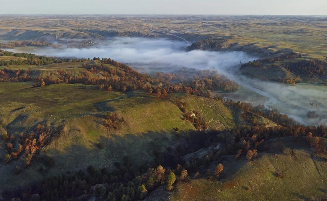
This is what the people of Cherry County set out as their vision for the Comprehensive Plan in 1997, and what they wanted to be able to say about their community in the future. We also seek to likewise honor our roots as we plan for the future grounded in this timeless Cherry County vision.
(FromtheCherryCountyComprehensivePlan1997)
Cherry County is a great place to live. The changes recent years have brought to our landscape have been well-managed by the community itself. There are still far more cattle than people, and everyone finds that balance acceptable.
The county's residents and communities are separated by many miles, but united by a shared history, the mutual respect of good neighbors, pride in being skilled stewards of the Sandhills landscape, and active participation in governing the communities, the county, the state, and the nation; Cattle Country traditions are cherished, but the cultures of all residents are respected. People care about each other and the land and water resources on which everyone depends.
Cherry County residents enjoy healthy lifestyles, a safe environment, and a stable economy. Public facilities and services, health care, education, and training, recreation and ·entertainment, and
employment and 'business opportunities are adequate to meet the needs of people of all ages. Efficient transportation and communication systems link people with each other, and the world, enhancingthe sense of communityand prosperity.
Private and public land and water resources are used wisely, sustaining for generations the ecological, economic, social,cultural, recreational, and aesthetic values that support the quality of life treasured by county residents. Maintaining these values also ensures that visitors have a memorable experience.
People could live other places. They choose to live in Cherry County.
Cherry County was named in honor of Lt. Samuel A. Cherry of the fifth United States Calvary of Ft. Niobrara, who was murdered May 11, 1881 in the line of duty. Cherry County is the largest county in Nebraska and the 44th largest in the United States comprised of 3,828,500 acres. Established on April 4th, 1883, it is located in north central Nebraska, along the Nebraska-South Dakota state line. The county is bounded on the north by the State of South Dakota and the Rosebud Indian Reservation, on the east by Brown County and Keya Paha County, on the south by Grant, Hooker, Thomas, and Blaine Counties, and on the west by Sheridan
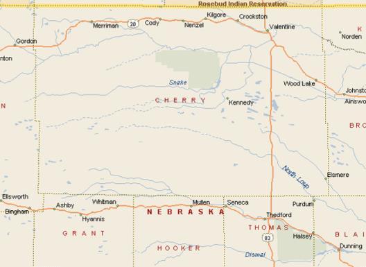
County.
Seven highways cross the county including Nebraska Highways 12, 61, 97, Spur 16B, Spur 16 F, US Highway 20 and US Highway 83. The county is home to the communities of Cody, Crookston, Kilgore, Merriman, Nenzel, Valentine (county seat) and Wood Lake; plus, the unincorporated communities of Brownlee, Elsmere, Purdum, Sparks and Eli.
Since the County’s founding, agriculture has been the way of life for the residents of Cherry County and the cause of the citizens’ economic prosperity. This continues today where beef cattle ranching is the dominate industry, earning Cherry County the national recognition of being the largest beef producing county in the United States. The robustness of this industry has occurred through the exceptional private land stewardship of its citizens, which has resulted in the improved grass cover of the unique sand dune system, known as the Sandhills, that dominates the Cherry County landscape.
The goals, objectives, and policies of this plan are designed to ensure this essential agriculture industry and those services that support it, work together to ensure the citizens will retain the ability to adapt, improve and advance their agriculture operations far into the future by maximizing effective land stewardship practices, protecting the private property rights of the citizens, and limiting government and other restrictions that diminish these rights.
The purpose of the Cherry County Comprehensive Plan is to help citizens and decision makers guide change into the framework of this vision, which includes both a traditional respect for property rights and a strong sense of responsibility and stewardship.
The goals, objectives and policies set forth in this Comprehensive Plan are developed to fulfill the following core principles:
1. All programs, services, activities and land-uses shall support, and not diminish, the continuation of the agriculture industry that is the foundation of Cherry Countyculture and prosperity;
2. Private property rights shall be fully protected, and those activities that erode the full use and enjoyment of these rights by the citizens shall be deterred or prohibited as allowed bylaw;and
3. Protecting the health, safety, and welfare of the citizens in the County’s highest priority and is the purpose for the policies contained within this plan.
These core principles are set forth to ensure the full measure of Article 1.1 of the Constitution of the State of Nebraska will be honored in Cherry County, which states:
“All persons are by nature free and independent, and have certain inherent and inalienable rights; among these are life, liberty, the pursuit of happiness, and the right to keep and bear arms for security or defense of self, family, home, and others, and for lawful common defense, hunting, recreational use, and all other lawful purposes, and such rights shall not be denied or infringed by the state or any subdivision thereof. To secure these rights, and the protection of property, governments are instituted among people, deriving their just powers from the consent of the governed.” (Neb. Const. art. I, sec. 1 (1875); Amended 1988, Initiative Measure No. 403.)
The Cherry County Comprehensive Plan is designed to promote orderly growth and development for the county, as well as providing policy guidelines to enable citizens and elected officials to make informed decisions about the future of the county.
The Comprehensive Plan will provide a guideline for the location of future developments and uses within the planning jurisdiction of Cherry County. The Comprehensive Plan is intended to encourage a strong economic base for the county so all goals can be achieved.
The Comprehensive Plan is intended as an information and management tool for county leaders to use in their decision-making process when considering future developments. The Comprehensive Plan is not a static document; it should evolve as changes in the land use, population or local economy occur during the planning period. This information is the basis for Cherry County’s evolution as it achieves its physical, social,and economic goals.
The Comprehensive Plan begins with the development of general goals and policies, based upon current and future issues faced by the county and its residents.These are intended to be practical guidelines for addressing existing conditions and guiding future growth.
In conjunction, the data collection phase will be occurring. Data is collected to provide a snapshot of the past and present conditions within the county. Analysis of data provides the basis for developing forecasts for future land use demands, as well as future needs regarding housing and facilities.
The Comprehensive Plan is a blueprint designed to identify, assess, and develop actions and policies in the areas of population, land use, transportation, housing, economic development, county facilities, and utilities. The Comprehensive Plan contains recommendations, when implemented, that will be of value tothe Countyand its residents.
The Comprehensive Plan identifies the tools, programs, and methods necessary to carry out the recommendations. Nevertheless, the implementation of the development policies contained within the Comprehensive Plan is
dependent upon the adoption of the Plan by the governing body, and the leadership exercised by the present and future elected and appointed officials of the County.
The Plan was prepared under the direction of Cherry County Planning Commission, with the assistance and participation of the Cherry County Board of Commissioners, Cherry County staff, the Plan Review Committee, and citizens of Cherry County. The time period for achieving the goals, programs, and developments identified in the Cherry County Comprehensive Plan is 20 years. However, the County should review the Plan annually and update the document every 10 years, or when major,unanticipated issues arises.
Completing updates every ten years or so will allow the County to incorporate ideas and developments not known at the time of the present comprehensive planning process.
Nebraska State Statutes require the inclusion of certain elements in a Comprehensive Plan. A “Comprehensive Plan,” as defined in Neb. Rev. Stat. § 23-114.02 (Reissue 1997), “shall consist of both graphic and textual material and shall be designed to accommodate anticipated longrangefuturegrowth”andcontainthefollowing elements:
1. A land-use element which designates the proposed general distribution, general location, and extent of the uses of land for agriculture, housing, commerce, industry, recreation, education, public buildings and lands, and other categories of public and private use of land;
2. The general location, character, and extent of existing and proposed major streets, roads, and highways, and air and other transportation routes and facilities;
3. When a new comprehensive plan or a full update to an existing comprehensive plan is developed,an energyelement which:
a. Assesses energy infrastructure and energy use by sector, including residential, commercial,and industrial sectors;
b. Evaluates utilization of renewable energy sources;
c. promotes energy conservation measures that benefit the community;and
4. The general location, type, capacity, and area served of present and projected or needed
community facilities including recreation facilities, schools, libraries, other public buildings, and public utilities and services.
The Cherry County Comprehensive Plan is comprised of the following chapters:
• Introduction
• Population
• Housing
• Economics/Economic Development
• CountyFacilities
• Parks and Recreation
• Public Safety
• Communication, Utilities,and Energy
• Hazards
• Natural Resources and the Environmental
• Land Use
• Transportation
• Implementation
Analyzing past and existing demographic, housing, economic and social trends permit the projection of likely conditions in the future. Projections and forecasts are useful tools in planning for the future; however, these tools are not always accurate and may change due to unforeseen factors. Also, past trends may be skewed or the data may be inaccurate, creating a distorted picture of past conditions. Therefore, it is important for Cherry County to closely monitor population, housing and economic conditions that may impact the County. Through periodic monitoring, the County can adapt and adjust to changes at the local level. Having the ability to adapt to socio-economic change allows the County to maintain an effective Comprehensive Development Plan for the future, to enhance the quality of life, and to raise the standard ofliving for all residents.
The Comprehensive Plan records where Cherry County has been, where it is now, and where it likely will be in the future. Having this record in the Comprehensive Development Plan will serve to inform County officials as much as possible.
Nebraska Revised Statutes §23-114.03 states: Zoning regulations shall be adopted or amended by the county board only after the adoption of the county comprehensive plan by the county board and the receipt of the planning commission's specific recommendations. Such zoning regulations shall be consistent with an adopted comprehensive plan and designed for the purpose of promoting the health, safety, morals, convenience, order,
prosperity, and welfare of the present and future inhabitants of Nebraska, including, among others, such specific purposes as:
1. Developing both urban and nonurban areas;
2. Lessening congestion in the streets or roads;
3. Reducing the waste of excessive amounts of roads;
4. Securing safetyfrom fire and other dangers;
5. Lessening or avoiding the hazards to persons and damage to property resulting from the accumulation or runoff of storm or flood waters;
6. Providing adequate light and air;
7. Preventing excessive concentration of population and excessive and wasteful scattering ofpopulation or settlement;
8. Promoting such distribution of population, such classification of land uses, and such distribution of land development as will assure adequate provisions for transportation, water flowage, water supply, drainage, sanitation, recreation, soil fertility, food supply, and other public requirements;
9. Protectingthe tax base;
10. Protecting property against blight and depreciation;
11. Securing economy in governmental expenditures;
12. Fostering the state's agriculture, recreation, and other industries;
13. Encouraging the most appropriate use of land in the county;and
14. Preserving, protecting, and enhancing historic buildings,places,and districts.
The Comprehensive Plan provides policy direction for the elements listed above that are issues of concern and relevant to Cherry County. These can be found at the end ofthe Chapter discussions.
Zoning regulations shall be reviewed and developed to comply with the updated and approved Comprehensive Plan. Zoning regulations must comply with, and be consistent, with the adopted comprehensive plan.
The Cherry CountyBoard of Commissioners,which is a board of elected officials, performs the governmental functions for the County. Each incorporated community in Cherry County also has elected officials and officers overseeing how their communityis governed.
The planning and zoning jurisdiction of Cherry County, pursuant to Neb. Rev. Stat. § 23-114 (Reissue 1997), includes all of the unincorporated portions of the County, excluding the established extraterritorial jurisdiction of each incorporated city or village.
The Cherry County Comprehensive Plan is the one unifying plan that takes into consideration all the different land uses, types of land ownership, management objectives of Federal and State agencies, as well as the needs and requirements of cities and special districts within the County’s jurisdiction. The purpose of the Comprehensive Plan is to ensure the activities of all these entities are harmonized and do not conflict with each other or the Counties policies, to ensure the health, safety andwelfareofCherry County’scitizens.
Because of this responsibility, delegated by the State of Nebraska to Cherry County, all entities must consider and coordinate their management plans with the Cherry County Comprehensive Plan as required by State and Federal Law.



Population is the major catalyst driving everythingin a municipality or a county including housing, local employment, economies and fiscal stability. It is critical to understand how past population trends, when applied to the future, impacts the overall area. Cherry County needs to understand where the County has been, where it is currently, and where it appears tobe going.
Understanding the historic populations aid in identifying where the population may go in the future and aids in determining potential impacts on future housing, retail, medical, employment, and educational needs within Cherry County. In addition, when future populations appear to be declining, it provides a benchmark from which to direct and gauge economic development activities.
Projections provide an estimate for the County to base future land use and development decisions. However, population projections are only estimates and unforeseen factors may affect projections significantly.
The population from 1980 through the 2020 Environmental Systems Research Institute (ESRI) estimates can be found in Figure 2.1 for Cherry County, as well as the incorporated communities within the county, and the unincorporated areas. The data provide a look at where the county has been and allows for the eventual projection of populations in the County. Figure 2.2 contains the population data for each community, for the same period, but shown at a more legible scale.
Overall, Cherry County has seen a –10.0% (-673 people) decline in population from 1980 to 2020. This decrease was based mostly on the population loss in the unincorporated portions of the county. The unincorporated portions of Cherry County declined by 640 people or –18.8% from 1980 to 2020. Valentine saw an actual increase of 11 people or 0.4%. Growth within the smaller municipalities has been mixed with some slight decreasesand increases.
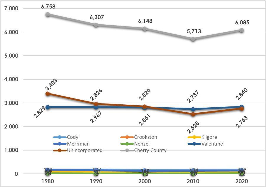
Source: U.S. Census Bureau 1980 - 1990, 2000, 2010, ESRI Business Analyst 2020
IGURE 2.2: COMMUNITY POPULATIONS, CHERRY COUNTY 1980 TO 2020
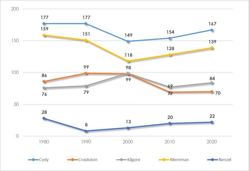
Source: U.S. Census Bureau 1980 - 1990, 2000, 2010, ESRI Business Analyst 2020
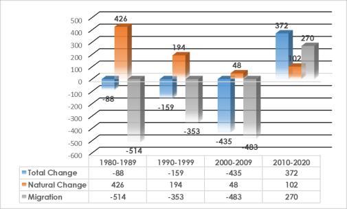
Sources: Nebraska DHHS 1980-2018, ESRI Business Analyst 2020
Migration Analysis is a tool which allows the County to understand critical dynamics of the population shifts. Total Migration indicates the population size migrating in or out of the County over a given period oftime.
Figure 2.3 indicates the overall population change, countywide, as well as the two key components of population change,migration and natural change.
Overall from 1980 to 2020, Cherry County has declined by 310 people. The overall decline was mostly associated with out-migration, which saw 1,080 people move out of Cherry County over the 40 year period.
During the 40 year period births exceeded deaths every decade between 1980 and 2020. During the time period, there were 770 more births in Cherry Countythan deaths.
Age structure is another important component of population analysis. By analyzing age structure, one can determine a key dynamic affecting the population of Cherry County. Note: the data in Figure 2.3 is based on a calendar year and the data in Table 2.1 is for 2012 and 2022.
Each age group affects the population in a number of different ways. For example, the existence of large younger age groups (20-44 years) means there is a greater ability to sustain future population growth compared to large older age groups. Understanding what is happening within the age
Source: American Community Survey 2008-2012 & 2018-2022.
groups of the county’s population is necessary to effectivelyplan for the future.
Table 2.1 contains the age group structure for Cherry County in 2012 and 2022. The examination of age structure provides an understanding of where some of the population shifts are occurring. These data allow for a better understanding of what could occur in the future. Reviewing population in this manner permits a detailed analysis of which specific groups are moving in and out of the county. Negative changes in a group indicate out-migration or a combination of outmigration and deaths.
Cherry County saw growth in five age groups. The 0-4 and 5-9 groups are always an increase, since these individuals were not alive for the 2012 American Community Survey. Outside of the 2022 age groups of 0-4 and 5-9 years,the other increases were in the 10-14, 15-19, 30-34, 35-39, and 40-44 age groups. Overall, there was an increase of 1,086 persons in these age groups. When you eliminate the first two younger populations, 365 people actually moved into Cherry County during this period. This population increase consisted primarily of familyaged adults and children.
There were five age groups from 2012 with declining numbers in 2022. The group with the greatest loss was the 85 years+ (2022), which lost 379 persons over the period. This loss can be attributed totwocauses: 1) people moving on after
75 years to other communities and senior care facilities, or 2) a dying population base. The latter is most likelysince between 2010 and 2020 there were 629 resident deaths in Cherry County. Overall, Cherry County saw significant decreases in key age groups with nearly all of the losses attributed to outmigration.
Between 2012 and 2022, the median age in Cherry County decreased from 47.1 years to 41.5 years. This decrease equaled approximately 6.0 years or -11.0% for the period. During this same period, the state of Nebraska increased its Median Age from 36.3 in 2012 to 36.9 in 2022 or an increase of 0.6 years or 1.6%.
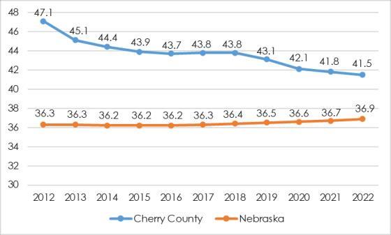
Source: American Community Survey 2008-2012 & 2018-2022.
Dependency ratios examine that portion of Cherry County’s population which is supporting age groups historically dependent upon others for survival (18 years and under and 65 years and older), see the box above for details on calculating the ratio. The importance of this ratio focuses on the number of dependent persons and is there enough employed persons in the county to support these populations as wellas themselves.
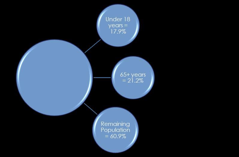
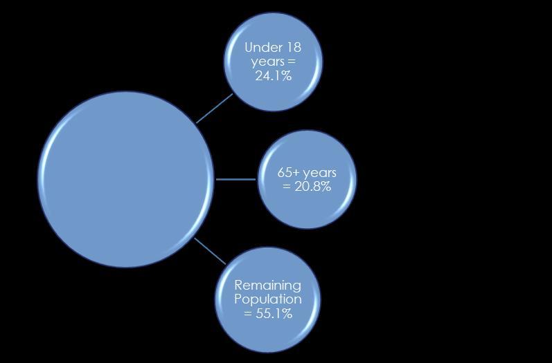
Figures 2.5 and 2.6 indicate the dependency ratios for 2012 and 2022 in Cherry County. The portion of persons less than 18 years of age increased by 6.2% between 2012 and 2022; while those aged 65 years and older decreased by –5.8%overall.

The dependency ratio examines the portion of a community’s earnings that is spent supporting age groups typically and historically dependent on the incomes of others.
< 1: 1 Independent resident is able to support more than 1 Dependent resident
=1: 1 Independent resident able to support 1 Dependent resident
>1: 1 Independent resident able to support less than 1 Dependent resident
(%18 years and younger + %65 years and older) % of remaining population
Dependency Ratio = 0.75
In 2012, Cherry County had a Dependency Ratio of 0.75 (39.1%/60.9%); however, by 2022 the Ratio had increased to 0.81 (44.9%/55.1%). This is supported by the increase in the 18 and under age group, plus the decrease in the 65 and older group.
Cherry County saw increases in most non-white ethnic groups between 2012 and 2022.
Source: American Community Survey 2018-2022
Cherry County during the past decade has seen a slight shift in ethnicity within the County. Analysis of the ethnicity provides more detail as to the changes being seen in a county. Ethnicity is more than additional people living in the county since these new residents bring their own cultures and beliefs to the area; some of these may not mesh well with those already in place. The changes in
Source: American Community Survey 2008-2012 & 2018-2022.
The largest changes (numerically) were the Two or More Races and the White alone population. The Two or More Races population saw an additional 296 people (209.9%); while, the White alone shrunk by178 people (-3.3%)between 2012 and 2022.
The third largest change (numerically) was the Hispanic of any race population. The Hispanic population shrunk by 80 (11.1%) people between 2012 and 2022.
Population projections are estimates based upon past and present circumstances. The use of population projections allows Cherry County to estimate the potential population in future years by looking at past trends. By scrutinizing population changes in this manner, the County will be able to develop a baseline of change from which future scenarios can be generated. A number of factors (demographics, economics, social, etc.) may affect projections positivelyor negatively.
At the present time, these projections are the best crystal ball Cherry County has for predicting future population changes. There are many methods to project the future population trends; the projection technique used below are intended to give Cherry County a broad overview of the possible population changes that could occur in the future.
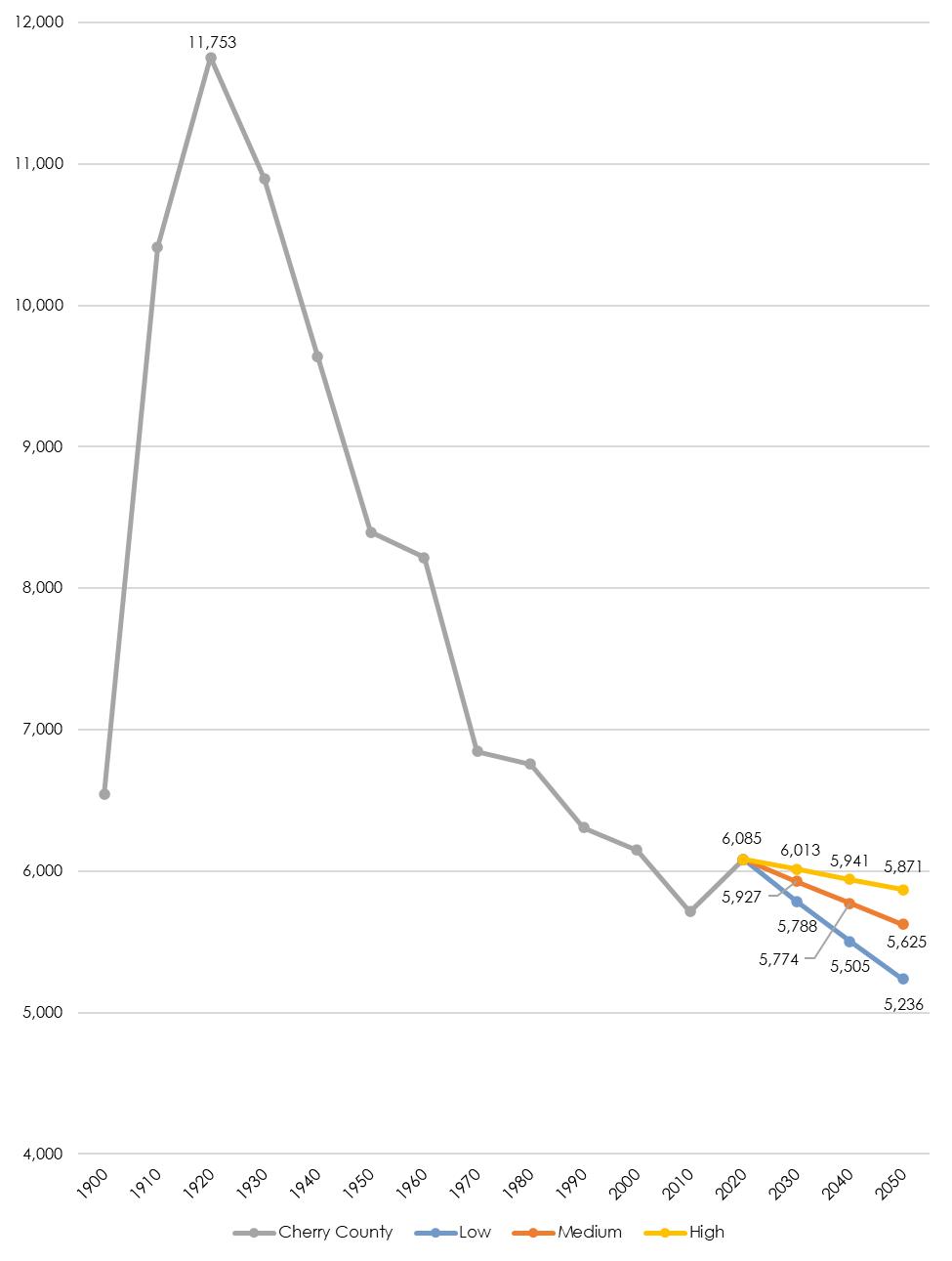
Trend Line Analysis is a process of projecting future populations based upon changes during a specified period of time. In the analysis of Cherry County, four different trend lines were reviewed: 2000 to 2020, 1980 to 2020, 1990 to 2020, and 1960 to 2020. A review of these trend lines indicates Cherry County will see varied levels of population changes between now and 2050. The following projections summarize the decennial population for CherryCountythrough 2050.
Three population projection scenarios were selected and include (1) a Low Series; (2) a Medium Series; and, (3) a High Series.
LOW: The 60-year projections are the Low Series and may be considered a worst-case scenario. This is unlikely to occur yet serves as a baseline for planning purposes. If the County is prepared for population at this level, they will be prepared for more moderate population change.
MEDIUM: The long-term 40-year trend serves as the Medium Series.
HIGH: The 30-year trend was selected as the High Series. This is an optimistic scenario which can also serve as a goal to continue the recent trend moderating the historical contraction of population and working
Cherry County Trend Analysis
persons
persons
5,505 persons
5,236 persons
to 2020
persons
persons
5,774 persons
5,625 persons
towards growth.
Figure 2.7 reviews the population history of Cherry County between 1900 and 2020, and identifies the three population projection scenarios into the years 2030, 2040, and 2050. Figure 2.7 also indicates the peak population for Cherry County occurred between 1910 and 1930. Since 1930, the population of the County has been on a declining trend line; however, the trend between 2010 and 2020 indicated an upward trend with growth of 6.51% or 372 people.
to 2020
persons
persons
persons
5,871 persons
persons
persons Low = 1960 to 2020
persons
persons
persons
persons Medium = 1980 to 2020
persons
persons
persons
5,625 persons High = 1990 to 2020
persons
persons
5,941 persons
5,871 persons
Sources: U.S. Census Bureau 1970 - 2020, Marvin Planning Consultants




The Housing Profile identifies existing housing characteristics and conditions for Cherry County. The primary goal of the housing profile is to allow the County to examine past and present conditions, while, identifying potential needs including provisions for safe, decent, sanitary, and affordable housing for every family and individual residing withinthe County.
Projecting future housing needs requires several factors to be considered. These factors include population change, household income, employment rates, land use patterns, and residents' attitudes.
The following tables and figures provide the information to aid in determining future housing needs and develop policies designed to accomplish the housing goals for Cherry County.
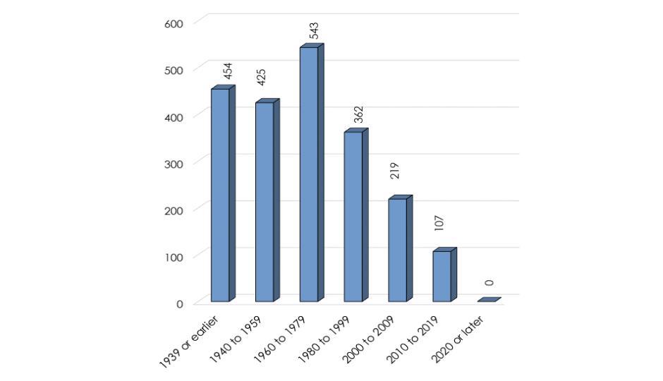
An analysis of the housing stock age can reveal a great deal about population and economic conditions of the past. Examining the housing stock is important in order to understand the overall qualityof housing in Cherry County.
Sources: American Community Survey 2018-2022
Figure 3.1 indicates 454 homes, or 27.4% of Cherry County’s 1,656 total housing units,were constructed prior to 1940. This statistic is county- wide, including each community, and will consist of older well-kept homes as well as homes likely in need of repair or demolition.
Cherry County saw very positive construction activity between 1960 and 2009 with 1,330 (80.3%) homes constructed. This was especially true between 1960 and 1999 which saw 1,859 (58.4%) new homes built during the four decades. These data indicate the economy was relatively good during these decades. Between 2000 and 2009, Cherry County saw new housing drop off to only 219 units and then only 107 units between 2010 and 2019.
A total of 85.8% of all housing units in Cherry County were constructed prior to 1980. Due to the age of these homes, there may be a need for special weatherization programs in the County and communities to bring these homes up to current energyefficiencystandards.
Figures 3.2 through 3.10 identify several different housing characteristics in Cherry County. The figures indicate the breakdown between owner– and renter-occupied housing as well as the number of people living in group quarters.
PERSONS IN HOUSEHOLDS/GROUP QUARTERS
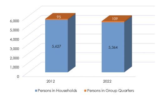
In 2022 there were 263 less people living in households than in 2012, this represents a change of –4.6%. Between 2012 and 2022, the number of people living in group quarters went from 95 people in 2012 to109 in 2022,a change of 14.7%.
PERSONS PER HOUSEHOLD
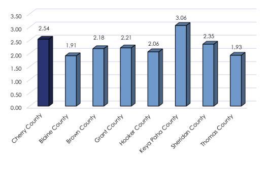
Figure 3.3 also includes the number of persons per household. The average persons per household in Cherry County in 2020 was 2.54 persons. The trend
FIGURE 3.2: HOUSING POPULATIONS
Sources: American Community Survey 2008-2012 & 2018-2022.
FIGURE 3.3: PERSONS PER HOUSEHOLD - 2020
Source: American Community Survey 2018
nationally has been towards a declining household size; however, the persons per household in Cherry County is average for the entire north-central Nebraska region. The region average is 2.28 persons per household. The surrounding counties in 2022 were:
• Blaine Countyhas 1.91 persons/household
• Brown Countyhas 2.18 persons/household
• Grant Countyhas 2.21 persons/household
• Hooker Countyhas 2.06 persons/household
• Keya Paha Countyhas 3.06 persons/household
• Sheridan Countyhas 2.35 persons/household
• Thomas Countyhas 1.93 persons/household
OCCUPIED VS. VACANT HOUSING UNITS
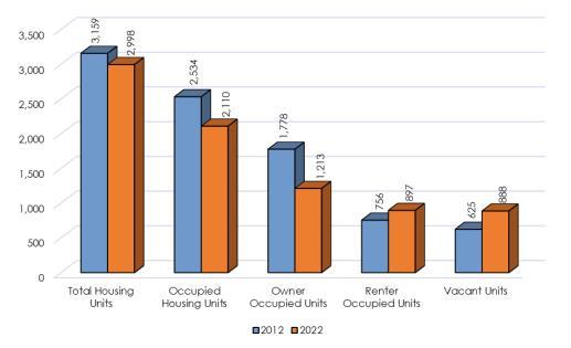
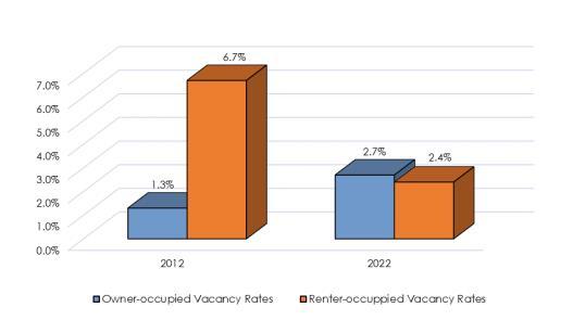
Occupied housing units in the County decreased by -16.7% between 2012 to 2022; this was a 424 unit increase over 2012. During the same time frame, vacant housing units increased from 625 units to 888 units or 42.1%. Between 2012 and 2022 vacancy rates basically tightened up with owner-occupied
FIGURE 3.4: OCCUPIED VS. VACANT HOUSING
Sources: American Community Survey 2008-2012 & 2018-2022.
FIGURE 3.5: VACANCY RATES BY TYPE OF UNIT
Sources: American Community Survey 2008-2012 & 2018-2022.
rate increasing slightly from 1.3% to 2.7% and renteroccupied dropped from 6.7%to2.4%in 2022.
MEDIAN GROSS RENT
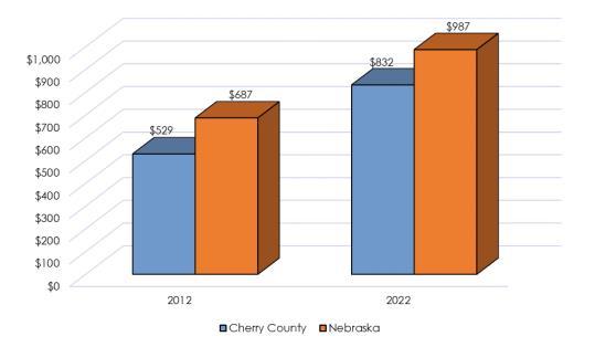
Median gross rent in Cherry County increased from $529 per month in 2012 to $832 per month in 2022, or 57.3%. The State’s median monthly gross rent increased by 43.7%. This indicates Cherry County has seen a gross rent increase 84.2% of the State. However, the County’s median gross rent was 77% of the State’s median gross rent in 2012. Meaning the county lost ground to the state in this housing condition.
Comparing changes in monthlyrents between 2012 and 2022, with the Consumer Price Index (CPI), enables the local housing market to be compared to national economic conditions. Inflation between
FIGURE 3.6: MEDIAN GROSS RENT CHERRY COUNTY AND NEBRASKA 2012-2022

= 25%

Sources: American Community Survey 2008-2012 & 2018-2022.
2012 and 2022 increased at a rate of 25%, indicating Cherry County’s rents increased over 1.5 times the rate of inflation for the 10-year period. Thus on average, Cherry County tenants were paying considerably more in monthly rents in 2022, in terms of real dollars, than they were in 2012. Landlords were potentially making more on their investment.
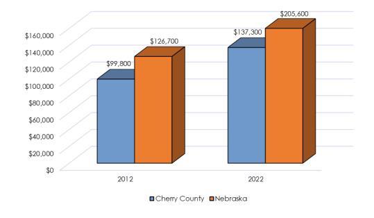
The median value of owner-occupied housing units in Cherry County increased from $99,800 in 2012 to $137,300 in 2022, and represents an increase of 37.5%. The median value for owner-occupied housing units in the state showed an increase of 62.2%. Housing values in Cherry County grew at approximately 0.8 times slower than the state. In addition, the median value of an owner-occupied unit in Cherry County was 78.7% of the state median in 2012 and 66.7%in 2022.
In comparison to the CPI, the local value of owneroccupied housing increased at a rate greater than the CPI. This indicates housing values in the County were worth more in 2022 compared to2012 dollars.
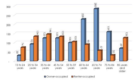
Figure 3.8 and 3.9 show tenure (owner-occupied and renter-occupied) of households by number and age of persons in each housing unit. Analyzing these data gives Cherry County the opportunity to determine where there may be a need for additional housing.
IGURE 3.7: MEDIAN VALUE OWNER-OCCUPIED CHERRY COUNTY AND NEBRASKA 2012-2022


Sources: American Community Survey 2008-2012 & 2018-2022.
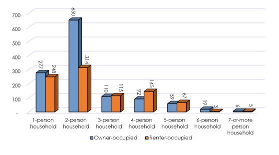
Sources: American Community Survey 2018-2022. FIGURE 3.8: PERSONS BY HOUSEHOLD TYPE - 2022
In 2022, the largest section of owner-occupied housing in Cherry County was in the two-person household, with 650 units or 53.6% of the total owner-occupied units. The largest household size for renter-occupied units was also two-person households with 314 renter-occupied housing units, or 35%of the total rentals.
In 2022, the age cohorts representing the largest home ownership group were those 65 to 74 years. Of the total residents living in owner-occupied housing units, 23.5% were between 65 and 74 years of age. The 60 to 64 age group was second with 18.8% of the total owner-occupied units.
The renter-occupied housing was also dominated by the four different cohort groups; 35 to 44 years (16.3%), 25 to 34 years (14.9%), 45 to 54 years (14.8%), and 85 years and older (14%). These four cohorts represent 60% of all the renter-occupied units in 2022.
Cherry County was comprised of 1,489 1- or 2person households, or 70.9% of all households; which represents 7/10 households in Cherry County. Countywide, households with 5- or more persons accounted for 159 units, or 7.6% of the total.
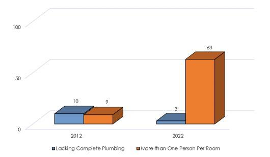
According to the U.S. Department of Housing and Urban Development (HUD) guidelines, housing units lacking complete plumbing or that are overcrowded are considered substandard housing units. HUD defines a complete plumbing facility as hot and cold-piped water, a bathtub or shower, and a flush toilet; overcrowding is more than one person per room. In addition, anytime there is more than 1.0 persons per room, the housing unit is
Sources: American Community Survey 2018-2022.
considered overcrowded,thus substandard.
This criteria, when applied to Cherry County, 19 units were substandard in 2012. This figure was reached by adding the number of housing units meeting one criterion to the number of housing units meetingthe other criterion.
In 2022, the total number of substandard housing units increased to 66 units. The primary contributing factor was overcrowding, which accounted for nearly 87.5% of the substandard issue. There was a 2000% percent increase in overcrowded units in Cherry County over the past decade from 3 units to 63 units.
What these data fail to consider are housing units that have met both criterion and counted twice. Even so, the County should not assume these data overestimate the number of substandard housing. Housing units containing major defects requiring
Sources: American Community Survey 2008-2012 & 2018-2022.
rehabilitation or upgrading to meet building, electrical, or plumbing codes should also be included in an analysis of substandard housing. A comprehensive survey of the entire housing stock should be completed every five years to determine and identify the housing units that would benefit from remodeling or rehabilitation work. This process will help ensure that a county maintains a high quality of life for its residents through protecting the qualityand quantityof its housing stock.
Housing Goal 1
Housing developments other than those associated with a farming or ranching operation should be located in or adjacent to the municipalities of the county.
Housing Policies and Strategies
H-1.1 Subdivision developments should be limited in the rural areas of Cherry County.
H-1.2 Housing density should be established in the Cattle Country Agricultural District for housing not associated with a farming or ranching operation.



Economic data are collected in order to understand local changes in economic activityand employment needs and opportunities within Cherry County. In this section, employment by industry, household income statistics, and commuter analyses were reviewed for Cherry County and Nebraska.
Income statistics for households are important in determining the earning power of households in a county. The data within show household income levels for Cherry County in comparison to the state. These data were reviewed to determine whether households experienced income increases at a rate comparable to the state of Nebraska and the Consumer Price Index (CPI).
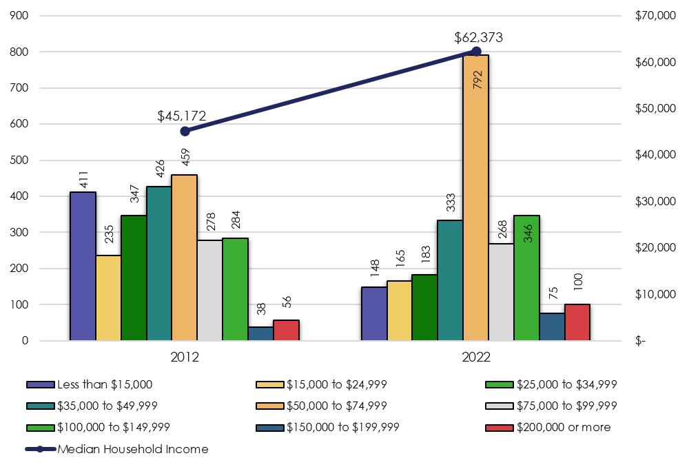
Figure 4.1 indicates the number of households in each income range for Cherry County for 2012 and 2022. In 2012, the household income range most commonly reported was $50,000 to $74,999, which accounted for 18.1% of all households.
In 2022, the $50,000 to $74,999 range was also the most commonly reported income range and represented 32.8% of the total households.
Those households earning less than $15,000 decreased from 16.2% in 2012 to 6.1% in 2022. The level of change was based upon more households moving into the middle to lower-high income ranges. However, those households earning less than $15,000 account for the poorest of the poor in the county.
In addition, the households earning less than $35,000 in 2012 accounted for 39.2% of the households. By 2022 the numbers decreased to 20.5% of the households. Therefore, in 2023 79.5% of the households were earning more than $35,000.
The median household income for Cherry County was $45,172 in 2012, which was considerably less than State median income of $51,381. In 2022 the median household income was at $62,373 or an increase of 38.1% since 2012. However, the 2012 and 2022 median household incomes were still less than the State of Nebraska median household income.
The CPI for this period was 25%, which indicates household incomes in Cherry County exceeded inflation. Therefore, households were actually earning more in real dollars in 2022 than in 2012. This difference basically indicates for every $1.00 earned in a household during 2012, it was earning over $1.25 in 2022.
FIGURE 4.1: HOUSEHOLD INCOME


Source: American Community Survey 2008-2012 & 2018-2022.
FIGURE 4.2: INCOME BY SOURCE 1982 TO 2022


Source: Bureau of Economic Analysis, Regional Economic 1982-2022


Source: BEA, Regional Economic 1982-2022
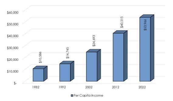
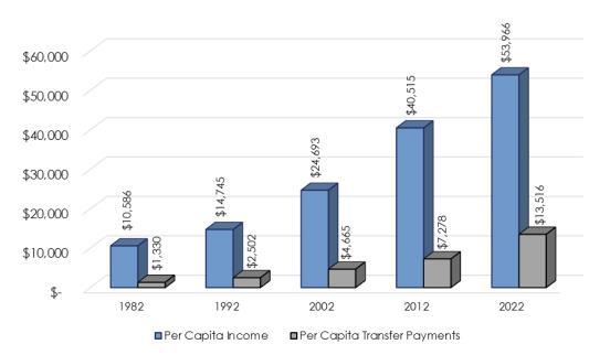
The graph to the left (Figure 4.2) shows personal income by source for Cherry County. These data are compared to the CPI, in order to determine if increases are consistent with inflation and in terms of real dollars.Between 1982 and 2022,the CPI was 204%.
Overall Personal Income in Cherry County went from $71,591,000, in 1982, to $294,869,000, in 2022 or an overall increase of 311.9%. Total personal income for the county increased by around 1.1 times the rate of inflation over the 40 year period.
Non-farm income increased from $61,702,000 in 1982 to $262,568,000 in 2022, or an increase of 325.5%, which was around 1.2 times the CPI. By 2022, farm income had risen from $9,889,000 to $32,301,000, or 226.6%, surpassing the CPI.
The per capita income in Cherry County increased from $10,586 in 1982 to $53,966 in 2022, or an increase of 409.8%, which was 2.0 times the CPI. Cherry County’s per capita income was 84.0% of the state’s per capita income level of $64,263 (Figure 4.3).
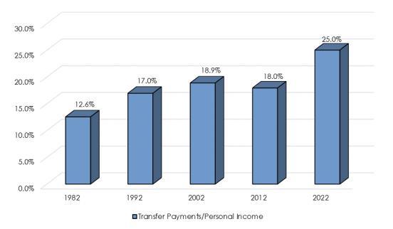
The trend for transfer payments per capita between 1982 and 2022 indicates payments increased significantly to individuals in Cherry County, increasing by nearly 916.2% in 40 years. However, transfer payments, as a proportion of per capita income, increased at a much lower rate between 1982 and 2022. In 1982, transfer payments comprised 12.6% of total per capita income, and
Source: BEA, Regional Economic 1982-2022
Source: BEA, Regional Economic 1982-2022
in 2022, transfer payments were 25.0% of total per capitaincome,which is an annual increase of 0.3%.
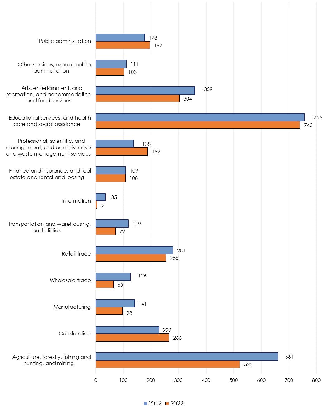
Analyzing employment by industry assists a community in determining the key components of their labor force. This section indicates the type of industries making up the local economy, as well as identifying particular occupations employing residents. Figure 4.7 indicates employment size by industry for Cherry County for 2012 and 2022 (these data indicate the types of jobs residents have, not the number of jobs locally).
The employment sector with the most employees in 2012 was Educational services, and health care and social assistance. This sector employed 756 people or 23.3% of the total employed residents in 2012. In 2022, the largest employment sector was
Source: American Community Survey 2008-2012 & 2018-2022.
In 2012, the overall top five industries in Cherry County were as follows: Industry People
Educational,health,and social services 756
Ag./forestry/Fishing/and Hunting and Mining 661
Arts,Entertainment,recreation,accommodations, and food services 359 Retail Trade 281
Construction 229
By2022, the overall top five industries in Cherry Countywere as follows:
Arts,Entertainment,recreation,accommodations, and food services 304
Construction 266 Retail Trade 255
still Educational, health, and social services with 740 employees or 25.3% of the total. The second largest sector in 2022 was Agriculture, forestry, fishing and hunting, and mining with 523 employees or 17.9% of the total.
The following data examine five occupational areas established by the U.S. Census Bureau to evaluate trends in employment and the area economy. Basic employment and non-basic employment are defined as follows:
• Basic employment is business activity providing services primarily outside the area through the sale of goods and services, the revenues of
which are directed to the local area in the form of wages and payments tolocal suppliers.
• Non-Basic employment is business activity providing services primarily within the local area through the sale of goods and services, and the revenues of such sales re-circulate within the community in the form of wages and expenditures bylocal citizens.
In order to establish a number of Basic jobs, a comparative segment or entity must be selected. For purposes of this analysis, the state of Nebraska will be used. This allows the analysis to establish where Cherry County is seeing exports from the state as a whole.
This analysis is used to further understand which occupational areas are exporting goods and
TABLE 4.1: BASIC/NON-BASIC BY OCCUPATIONS - 2022
Source: American Community Survey 2018-2022
services outside the area, thus importing dollars into the local economy. The five occupational categories used in the analysis are listed below:
• Managerial business, science, and arts occupations
• Service occupations
• Sales and office occupations
• Natural Resources, construction and maintenance occupations
• Production, transportation and material moving occupations
A related concept to the basic/non-basic distinction is the Base Multiplier.The base multiplieris a number, which represents how many non-basic jobs are supported by each basic job. A high base multiplier means that the loss of one basic job will have a large potential impact on the local economy if changes in employment occur. The rationale behind this analysis is that if basic jobs bring new money into a local economy, that money becomes the wages for workers in that economy. Therefore, more money brought in by basic jobs creates more non-basic jobs that are supported.
The occupation categories are compared to the same categories for the state and where Cherry County’s percentage exceeds the state’s percentage there is Basic employment. Table 4.1 indicates there are two categories, in the light blue color, having Basic employment. These two occupation sectors are Service occupations and Natural Resources, construction and maintenance occupations.
Overall, 15.3% of the employment base in Cherry County is tied to the exportation of goods or services. The county needs to continually work on their Business Retention and Expansion process in order to make these employers stay in Cherry County.
The information in Table 4.1 shows Cherry County has a base multiplier of 2.7, which means for every job considered to be basic, 2.7 other jobs in the county are supported and/or impacted. This is illustrated by comparing the basic and non-basic percentages against each other. Therefore, if Cherry County lost just one of the jobs tied to exports then there is the potential to lose approximately 2.7 other jobs from the non-basic
employment side.
There is no magical multiplier a county can aim to achieve. Every county is different and the dynamics involved are different. The unique and ever changing dynamics are what make a particular county unique and attractive to different employers. It is critical for a county to determine their future vision for business and industry and work towards that end. As previously mentioned it is also critical to diligently work towards a successful Business Retention and Expansion program to support those employers already located in the county. Some counties become too focused on attracting the next big catch and forget about the opportunities existing employers can offer through expansion of their operations.
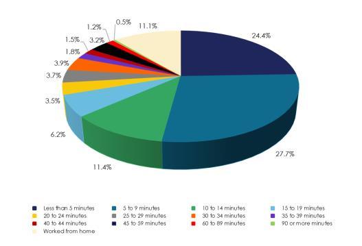
Figure 4.8 show the commuter characteristics for Cherry County in 2022. Travel time to work is another factor used to gauge where Cherry County’s workforce is employed. Figure 4.8 indicates, in 2022, 52.1% of the commuters were traveling 10 minutes or less to work. In addition, 11.1% work from home. 25.4% of commuters traveled 20 minutes or more towork.
Table 4.2 identifies key components affecting Cherry County’s agricultural profile. This Table examines the number of farms, size of these farms, cropland data, and certain value criteria for these farms.The data are for 1997 through 2017.
The table indicates the number of farms within Cherry County increased between 2002 and 2022,
Source: American Community Survey 2018-2022
breaking the trend throughout Nebraska. The total number of farms increased from 557 in 2002 to 610 in 2022,a change of 9.5%.
Table 4.2 also shows the total land in farms within Cherry County. From 2002 to 2022, Cherry County had a slight increase in the total land considered to be in farms. The overall increase was 0.49% or an approximate increase of 18,494 acres. The total land in farms accounts for 98.7% of the total acres in Cherry County, which is an increase from 98.2% in 2002.
The average size of each farm decreased from 6,781 acres in 2002 to 6,223 in 2022. This is in opposition to the national trend of farms increasing in size. The overall decrease was -8.2%. The total cropland in Cherry County increased from 425,907 acres in 2002 to435,881 acres in 2022.
The next data to review is harvested cropland. Harvested cropland is as it sounds, cropland actually harvested and yielded a crop. In 2002, the Harvested Cropland in Cherry County was 334,745 (78.5%) of Total Cropland and only 8.8% of the Total Land in Farms). By 2022 the Harvested Cropland increased to 355,077 acres (81.4%) of Total Cropland and only 9.3% of the Total Land in Farms).
Table 4.2 also shows the Estimated Market Values of Land and Buildings, both by average per farm and average per acre. In 2002, the average value per farm acre was $225. The average value increased in every Census of Agriculture until it reached an average per acre of $1,224 in 2022; an increase of 444.0%. The CPI for this same period was approximately 61%; therefore the average value per acre increased nearly 8 times the rate of inflation in Cherry County.
The increase in the average per acre also translates into an increase in the average per farm. The average value per farm in 2002 was $1,088,912 and increased to $7,616,737 in 2022, an overall increase of 599.4%. Again, this increase exceeded the CPI and the rate of inflation for the period. The average per farm, statewide, was $723,863 in 2002 and $3,397,806 in 2022, an increase of 369.4%. Therefore, the average farm value in Cherry County is over double the state average and the value has been growing at a greater rate thanthe state.
TABLE 4.2: AGRICULTURAL PROFILE CHERRY COUNTY 1997 TO 2017
Source: U.S. Census of Agriculture, 2002, 2007, 2012, 2022
Note: this data is self reported, and may reflect operations in more than one county. (D) Data Disclosure - Information Withheld
Source: U.S. Census of Agriculture, 2002, 2007, 2012, 2022
Note: this data is self reported, and may reflect operations in more than
Table 4.3 indicates the number of farms by size from 2002 to 2022. All categories experienced increases over the time period. The farm size indicating the greatest increase was the 1 to 9 acres which grew 24 farms or an increase of 600.0%. Overall, Cherry County went from 557 farms in 2002 to 610 farms in 2022 or a change of 9.5% for the period.
Table 4.4 indicates the number of farms and livestock by type for Cherry County between 2002 and 2022. The predominant livestock raised in Cherry County have been cattle and calves. Cattle and calves have been followed byBeef Cows. Both types of livestock production saw increases in the total operations in place. Both of these operation types saw an increase in the Average Number of Livestock Per Farm; Cow and calves went from 614 animals in 2002 to 701 per farm in 2022, which is the peak during the period. Beef Cows went from 355 per farm in 2002 to 396 per farm in 2022. There was one category which saw a decrease in both farms and animals;Milk Cows.
Table 4.5 indicates the number of farms and crop by type for the period from 2002 to 2022. The table shows the prominent crops grown in the county. In addition, the table indicates the total number of farms producing the specific crop and finally an average per farm.
Source: U.S. Census of Agriculture, 2002, 2007, 2012, 2022 Note: this data is self reported, and may reflect operations in more than one county.
Hay and Corn have been the two most frequently raised crops in Cherry County since 2002. Three of the seven categories shown increased in acres farmed; these include Corn for Grain, Wheat, and Soybeans. The crop with the largest percentage increase (acres) was Soybeans at 954.2%, while Corn for Grain increased by 158.5% and Wheat increased by15.2%.
Agriculture has historically been a major part of the Cherry County economy. It appears its importance
Source: U.S. Census of Agriculture, 2002, 2007, 2012, 2022 Note: this data is self reported, and may reflect operations in more than one county.
will only grow during the planning period of this document. It will be critical to maintain a balance in the type of livestock and grains raised in order to minimize future economic downturns.
With agriculture’s importance in the Cherry County economy,
strategies expanding this sector or at least maintaining its impact on the county’s economy. Even though agriculture, as shown in Figure 4.2, makes up 10.9% of the total Personal Income for Cherry County, the remaining 89.1% would be considerablylower or nonexistent.
Economic Goal 1
This plan and the accompanying zoning regulations should protect the culture and agricultural industry that is the foundation of Cherry County’s economic prosperity.
Economic Policies and Strategies
ECON–1.1 Conservation easements should be reviewed by the Planning Committee and Board of Commissioners pursuant to Neb. Rev. Stat. §76-2112(3) to ensure that proposed easements do not inhibit the continuation of unrestricted use of the lands for agriculture purposes. (See Conservation Easement Policy, Chapter 11)
ECON-1.2 Policies need to be adopted regulating non-agricultural uses within the Agricultural Districts.
Economic Goal 2
The plan and accompanying zoning regulations should protect the value and productivity of the land, to ensure the current and future economic stabilityof the Countyand its citizens.
Economic Policies and Strategies
ECON–2.1 Conservation easements and all conservation programs that change the use of the land should be reviewed by the Planning Committee and Board of Commissioners pursuant to Neb. Rev.
Stat. §76-2112(3) to ensure that proposed easements and programs do not reduce the taxable value of the land in the short-term nor in perpetuity. (See Conservation Easement Policy, Chapter 11)
Economic Goal 3
As a result of the conservation practices of the Cherry County agriculture community, Cherry County is home to some of the States most unique recreational uses. The economic policies of Cherry County will continue to foster “the state’s agriculture, recreation and other industries,” as required by Nebraska statue, by ensuring agriculture continues to be the priority use of the majorityof lands in the County.
ECON-3.1 Cherry County should require the review of all conservation easements and conservation programs that prioritize recreation uses and conservation purposes above agriculture use.
ECON-3.2 Easements transferred to a non-profit or entity potentially exempt from paying property taxes, should be reviewed by the Planning Commission and Board of Commissioners pursuant to Neb. Rev. Stat. §76-2112(3) to ensure proposed easements do not permanently reduce the taxable value of the lands. (See Conservation Easement Policy, Chapter 11)
ECON-3.3 Encourage additional tourism by promoting points of interest, recreation, hunting, fishing and the scenic beauty of Cherry County and the Niobrara River
valley. These items should always be driven by the local property owners and not state or federal governments. Expansion of recreational uses should be established in a manner that they protectthe existing localtax base.
Economic Goal 4
Recognizing that the local farmers and ranchers are by far the best individuals to decide the longterm economic and conservation practices of the region, the County should advance policies that help landowners productively use their lands independent of federal, state and other local programs that may lead to increased restrictions on the uses of the land.
ECON-4.1 The County encourages landowners to carefully review federal conservation agreements, for provisions which may lead to the restriction of land uses and reduction in the countytax base.
ECON-4.2 Cherry County desires for all landowners to enjoy the freedoms associated with land for future generations, as well as, protect the tax base allowing the County to provide specific services and protections toall.


State and local governments provide a number of services to their citizens and are referred to as public facilities. Public facilities represent a wide range of buildings and services built and maintained by the different levels of government.
It is important for all levels of government to anticipate the future demand for their services if they are to remain strong and vital. The analysis of existing facilities and future services are contained in the County Facilities Chapter. Alternatively, in some instances, there are a number of services not provided by the local or state governmental body and are provided by non-governmental private or non-profit organizations for the community as a whole. These organizations are important providers of services and are in integral part of the community.
The Facilities Plan component of a Comprehensive Development Plan reviews present public and private facilities and services.
The Facilities Plan for Cherry County is divided into the following categories:
• CountyBuildings
• Historic Sites and Places
• Education
• Health Care
COUNTY COURTHOUSE
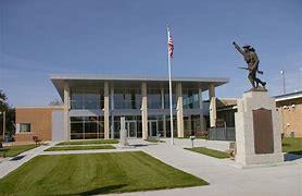
The original Cherry County Courthouse in Valentine was completed in 1901. This original courthouse was a masonry structure building. The courthouse had an annex constructed, in 1954, next to the 1901 structure. The annex contained many of the offices as well as the countyjail.
In 2011, the county added a new Justice Center to the existing County Courthouse Annex. The new Justice Center facility includes a 30-bed jail, law enforcement offices, courtroom and support offices, new entrance, lobby and circulation
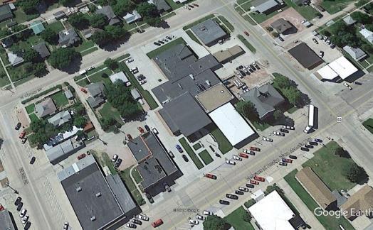
space. Areas of the existing courthouse Annex were also renovated to provide law enforcement space.
Source: https://www.beckenhauerconstruction.com
The courthouse houses the offices of the Clerk, Assessor, Treasurer, Election Commissioner, County Commissioners, Highway/County Road Department, Veteran’s Services Office, Nebraska Department of Health and Human Services, Justice Center, Clerk of the District Court, County Court, Emergency Management, Planning and Zoning, Extension Office, Register of Deeds, Weed Superintendent,andSheriff’sOffice.
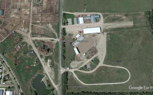
The Cherry County Fair takes place in August each year in Valentine and is operated by the Cherry County Ag Society. The grounds have a recently renovated hall, a new pavilion, two barns, a large rodeo arena,and parking.
Source:http://www.cherrycofairgrounds.com/
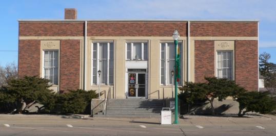
FORMER VALENTINE UNITED STATES POST OFFICE
The former Valentine United States Post Office, constructed in 1936-37, is a one-story, brick and limestone Modernistic style building. While the building retains a high degree of integrity, its historical significance derives from the mural painted on an interior wall. Through New Deal programs such as the Public Works of Art Project and the WPA Federal Art Project, thousands of artists were employed. In 1934, the Section of Painting and Sculpture (renamed the Section of Fine Arts in 1938) was organized under the auspices of the Treasury Department to provide murals and sculptures for the many federal buildings
constructed during the New Deal era. Between 1938 and 1942 the Treasury Department's Section of Fine Arts (generally known as "the Section") commissioned twelve murals for twelve newly constructed post offices in Nebraska. Valentine, along with the other eleven post office murals in Nebraska,represent the Section's goal of making art accessible to the general population by reserving one percent of new building construction budgets for art. Source: Nebraska Historical Society
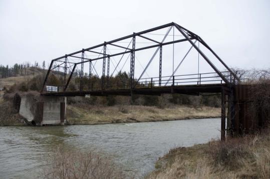
The County Line Bridge is a well preserved example of a Pratt through truss bridge type and retains all seven aspects of integrity. Following the flood of 1916, the Pratt through truss was widely used to replace damaged and destroyed bridges along the Niobrara River. It represents a once common bridge type for medium length river crossings in Cherry County, Nebraska. Source: Nebraska Historical Society
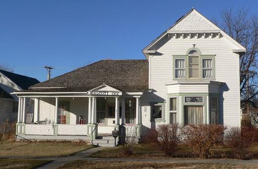
This one-and-one-half-story frame house, located in Valentine, is a simplified example of a NeoClassical Revival dwelling, based upon earlier Greek Revival style houses in the eastern and midwestern states. F. M. Walcott established one of the largest legal practices inthe state and alsoheld the offices of county judge and county attorney. Source: Nebraska Historical Society
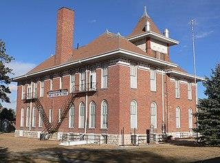
The bond issue to build the Valentine Public School was approved in February 1897. It was designed by Omaha architect Charles F. Beindorff, and construction was completed in 1898. The two-story brick structure was built for primary and secondary students of Cherry County School District 1. The building incorporates Queen Anne and Romanesque Revival design elements. The school is owned by the Centennial Hall Corporation, a nonprofit organization which uses it for community functions.Source: Nebraska Historical Society
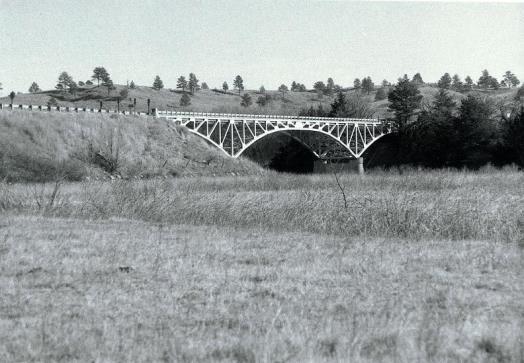
The Bryan Bridge, constructed in 1932, is located on a turnout off of U.S. Highway 20/83 over the Niobrara River about two miles southeast of Valentine. The 289-foot bridge consists of a 145-foot central steel pin-connected cantilever arch with 72foot half-arch anchor arms at each end. It was named after former governor Charles W. Bryan and is the only one of its kind in Nebraska. Source: Nebraska Historical Society
Although Cherry County is the largest county (in square miles) in Nebraska, early settlement did not occur until the late 1870s. By the early 1880s, however, settlement began to increase, spurred on in part by the construction of the railroad. In 1883 Cherry County was organized. The following year Valentine, the county seat, was incorporated. Initially, the county rented office space in Valentine. In 1900, voters approved a bond issue

to finance the construction of a courthouse. Events moved quickly thereafter and in November 1901 the courthouse opened its doors. Source: Nebraska Historical Society
The history of Sandhills ranch life is on display at Arthur Bowring Ranch State Historical Park, a 7,202acre ranch located three miles north and east of Merriman off Highway 20. Former U.S. Senator Eve Bowring managed the ranch until her death in 1985 at age 92. Her wish was to preserve the ranch as a turn-of-the-20th-century working cattle ranch and living historymuseum.
It’s a great opportunity to see ranch life up close. A visitor center houses artifacts and memorabilia of early ranching days. Corrals, barns, bunkhouses, and even a sod house are open to the public. The park also boasts a collection you might not expect on a ranch. Eve Bowring was a world traveler and passionate collector of antique china, silver, and glass. Her amazing collection is displayed inside the ranch house.
Buildings and grounds are open Memorial Day weekend through Labor Day, 8 a.m. to 5 p.m. The grounds are open from 9 a.m. to sunset the rest of the year. Source: https://visitvalentine.org/arthurbowring-ranch-state- historical-park/
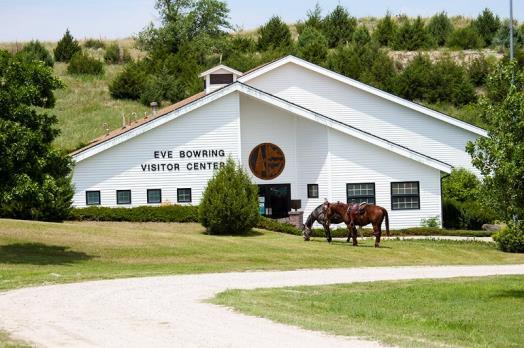
Photograph 6.9 Eve Bowring Visitor Center
Source: http://outdoornebraska.gov/bowringranch/
The Cherry County Historical Society Museum is a virtual treasure trove of the history of Cherry County, beginning with how it was settled and by whom. The museum has a variety of displays devoted to early-day cattlemen, Fort Niobrara, Native Americans, U.S. Wars, and the daily life of the pioneer era. An archival library includes historic newspapers and genealogical records. Located at the corner of Main Street and Highway 20, the museum is open Memorial Day to Labor Day, Thursday through Saturday from 1:00 p.m. to 5:00 p.m. or by appointment. Source: https:// visitvalentine.org/places/cherry-county-historicalsociety-museum/
The public schools in Nebraska are grouped into six classes, depending upon the type of educational services provided and the size of the school district. Cherry County is served by a total of seven public school districts:
• Cody-Kilgore Public Schools
• Gordon-Rushville
• Hyannis Area Schools
• Mullen Public Schools
• Thedford Public Schools
• Valentine CommunitySchools
The Cody-Kilgore Unified Schools serves approximately 158 PreK-12th grade students. It is located in North Central NE with a sparsely populated constituency yet covering one of the largest geographic areas among NE Class II Districts. The district provides regular transportation services for students that cover a 312 mile round trip in a 553 square mile area. Some students log as many as 76 miles round trip in a day on our buses. Our staff is 100% NCLB Qualified. They have received an Entrepreneurship and Incubator Business Grant with the Village of Cody. This enhances our Career Education curriculum by providing real world experiences. Expanded Distance Learning and Dual Credit classes are helping them provide more curriculum offerings. At CKUS they are: Committed, Knowledgeable, Unified,and Successful.


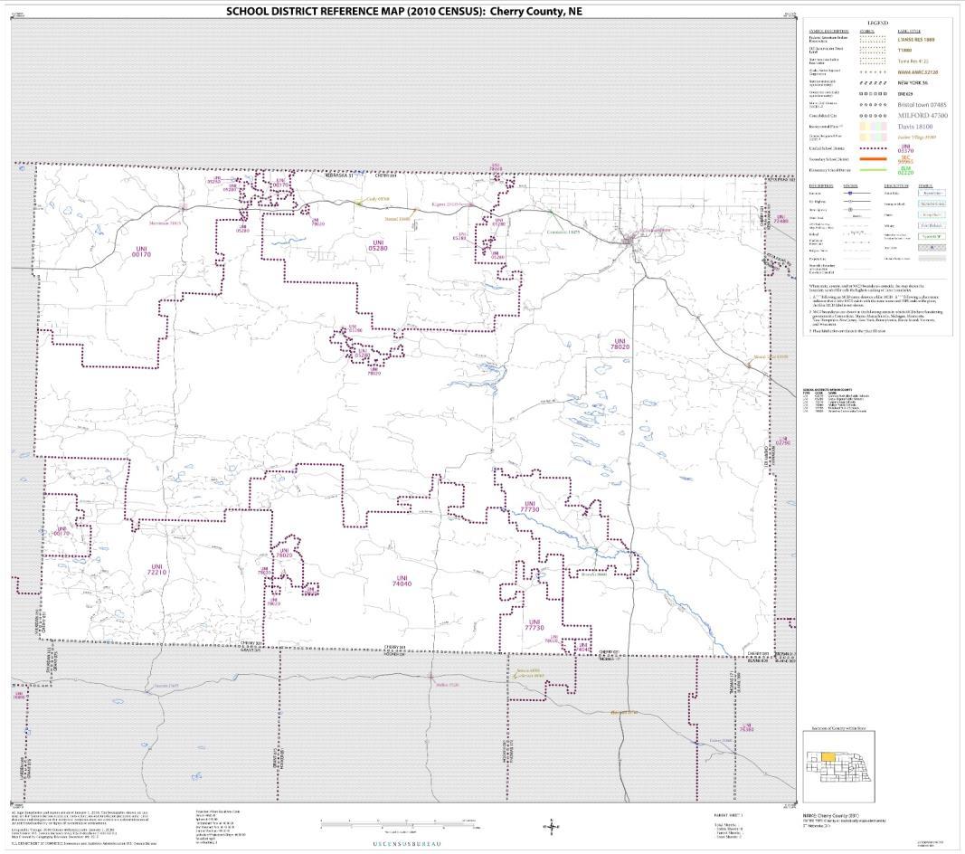


Source: US Census Bureau
There are twoschools in the District.
• Cody-Kilgore Elementary School located in Kilgore
• Cody-Kilgore Middle/High School located in Cody.
Source: https://nep.education.ne.gov//snapshot.html#81-0010000
GRPS is a consolidated district. The district covers 2300 square miles consists of one 9-12 high school located in Gordon, a 6-8 middle school located in
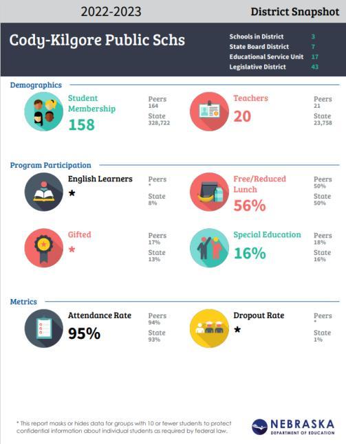
Source: Nebraska Department of Education
Rushville and two K-5 elementary schools including Pre-K located in Rushville and Gordon. Schools in the district are AdvancEd and NDE accredited. With a high poverty rate, bordering a socioeconomically impacted area, they are striving to positively impact student populations geographically and economically. GRPS has an enrollment of approximately 550 students and serves a population that is one fourth Native American. The district offers courses through distance learning and other modes of technology in addition to the district taught curriculum. The staff and students actively work with mentoring programs to build relationships, develop cultural awarenessand promote positive choices.
Source: https://nep.education.ne.gov//snapshot.html#81-0010000
Hyannis Area Schools is located in four different counties (Arthur, Cherry, Grant, and Sheridan) encompassing over 1,755 square miles. The district
Source: Nebraska Department of Education
has 20.0 FTE teachers and 1.5 FTE administrators. All teachers have been involved in the standards/ assessment process. The beautiful Nebraska Sandhills serve as a backdrop for the school district.
Source: https://nep.education.ne.gov//snapshot.html#81-0010000
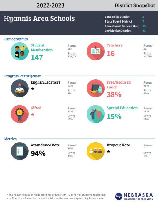
The Mullen School District is a Class III K-12 District encompassing an area of 1,383.8 sq. miles, including all of Hooker Co., 520 sq. miles of Cherry Co. and 72 sq. miles of Thomas Co. To meet these
Source: Nebraska Department of Education
needs of the vast district, Mullen Public Schools have adopted the Nebraska Standards and Assessment system. The elementary staff includes nine teachers and the secondary staff includes 15 teachers in particular content areas. All staff members have received extensive training provided by ESU #16. All Mullen teachers, K-12, have been trained through the Academic Literacy Project through ESU #10. A.L.P. helps teachers to focus on engagement, vocabulary and comprehension. Teachers share their expertise through structured learning walks allowing them to collaborate on improvement of instruction. Mullen experiences little student mobility and low staff turnover creating a very personal and positive learning environment. The school also participates in DIBELS, ACT,and NWEAMAP tests.
Source: https://nep.education.ne.gov/snapshot.html#46-0001000/about
THEDFORD PUBLIC SCHOOLS
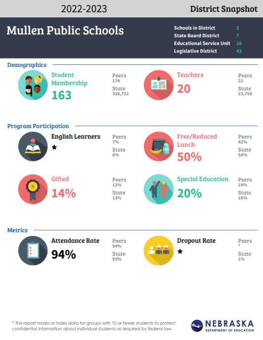
Thedford Public Schools is a Class III school located in the Sandhills cattle country of Nebraska. The student population consists of students covering a
Source: Nebraska Department of Education
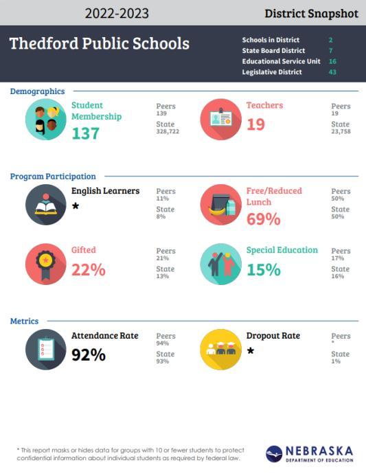
large, rural area. Many of the students drive from 5 to 50 miles to school each day. Total enrollment for the school, grades K-12, is 137 students. Preschool is offered to 3 and 4 year old students. They are at the crossroads of Highways 83 and 2 and are a hour from Broken Bow, North Platte, and Valentine. The student to teacher ratio is about 7:1, they offer iMac Laptops for students in grades 7-12, and have iMac carts and iPads for elementary students. They offer many activities outside of athletics, including HAL. SkillsUSA, FFA, FCCLA, One Act,and Speech. Source:https://nep.education.ne.gov//snapshot.html#81-0010000
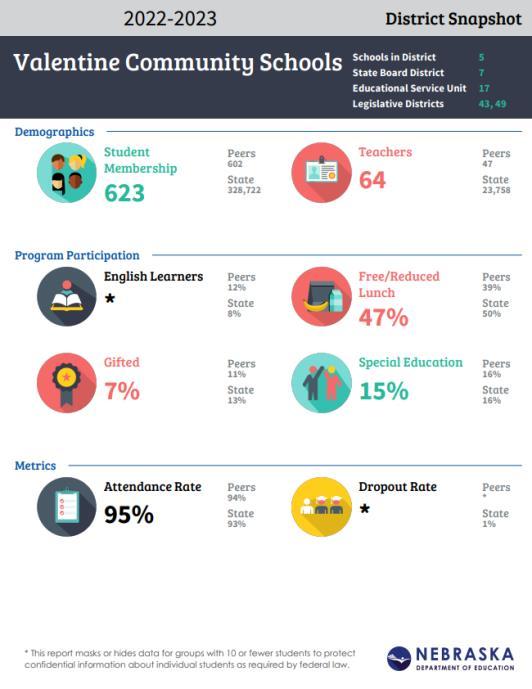
Valentine Community Schools is a class 3 district located in north central Nebraska. The district is comprised of Valentine High School, Valentine Middle School, Valentine Elementary, and four rural
FIGURE 5.6: DISTRICT SNAPSHOT - THEDFORD PUBLIC SCHOOLS (2022-2023)
Source: Nebraska Department of Education
attendance centers. Valentine Community Schools encompasses a geographic area of approximately 3400 square miles covering most of Cherry County. Source:https://nep.education.ne.gov/snapshot.html#16-0006000/about
PAROCHIAL SCHOOLS SERVING CHERRY COUNTY
There are two parochial school located in Cherry County.
Zion Lutheran School (K-8)in Valentine
Grace Lutheran School (K-8)in Valentine
FIGURE 5.7: DISTRICT SNAPSHOT - VALENTINE COMMUNITY SCHOOLS (2022-2023)
Source: Nebraska Department of Education
There is one post-secondary educational facility located in the county in Valentine. Mid-Plains Community College offers college classes, dual credit classes for high school students, and services as GED and English as Second Language classes.
The residents of Cherry County and the surrounding area have a large selection of in-state postsecondary schools to select. Some Nebraska institutions include:
• Chadron State College
• Northeast Community College
• Wayne State College
• Universityof Nebraska-Lincoln
• Hastings College
• Nebraska Wesleyan
• Union College
• Southeast CommunityCollege
• Central CommunityCollege
• Universityof Nebraska-Kearney
• Universityof Nebraska-Omaha
• Creighton University
• Universityof Nebraska Medical Center
• Methodist College of Nursing and Allied Health
• Midland University
Health care facilities in Cherry County are limited. There is only one hospital located in the county. The facility is Cherry County Hospital and Clinic located in Valentine.The Hospitalis a CountyHospital run by an appointed board.
Cherry County Hospital provides general medical and surgical care for inpatient and outpatient, as well as providing an emergency room. Below is a listing of several of their services, but it is not exhaustive. Among the services theyprovide are:
• Ambulance Service,
• Cardiology,
• Dialysis,
• Emergency Room,
• Home Health,
• Laboratory,
• Nursing Service,
• Physical Therapy,
• Occupational Therapy,
• Prenatal Care/Labor/Delivery,
• Radiology,
• Respiratory Therapy,
• Surgery
Source:www.cherrycountyhospital.org/getpage.php? name=mission&sub=About+Us
Educational Goal 1
Quality education is a vital component of positive growth. Although the County's role is limited, objectives and policies need to be established with regard to locating development to insure cost effective use of existing facilities.
Educational Policies and Strategies
ED-1.1 Continue to cooperate with the school systems in expanding public uses of educational facilities.
ED-1.2 The school districts should review all new development proposed within the zoning jurisdiction of Cherry County so they can accommodate future school populations.
Educational Goal 2
The county should coordinate with the school districts to insure adequate areas for future educational needs. Above all, the main goal is to encourage excellence in the school curriculum and facilities.
Educational Policies and Strategies
ED-2.1 Cooperate with school systems on any future expansion or the development of new joint facilities.
ED-2.2 Work with students to continually identify new facilities needed in the future.


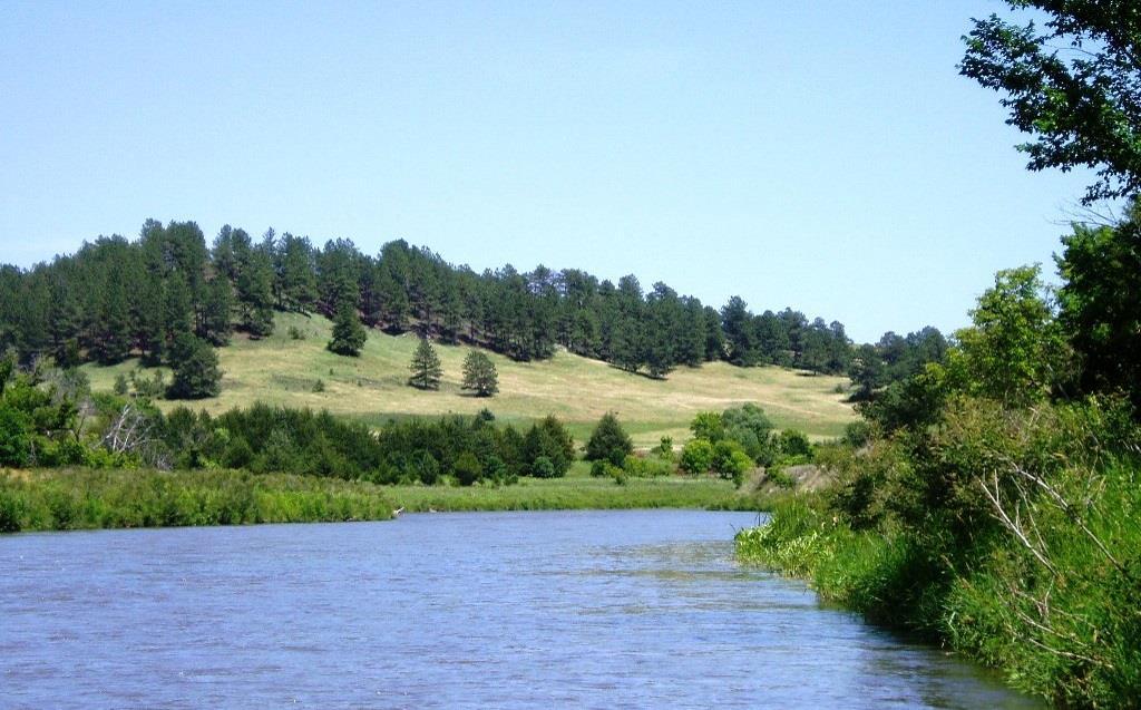
Cherry County has the most protected acres of land managed by the federal government in Nebraska. It is also home to several state parks and the Niobrara Wild and Scenic River.
Over the past decade the recreation use of the federal and state lands in the County has increased. The openness of Cherry Countyprovides many recreational opportunities for residents and visitors, winter and summer. Conflicts between recreation users and other users of the lands are minimal, and can be kept to a minimum when federal and state land managers coordinate their planning efforts and management activities with the County.
The following is a brief description of the facilities within the jurisdiction of Cherry County that are operated by the U.S. Department of Interior, Fish and Wildlife Service and National Park Service, the U.S. Department of Agriculture, Forest Service, the Nebraska Game and Parks Commission, and CherryCounty.
FORT NIOBRARA NATIONAL WILDLIFE REFUGE
Fort Niobrara National Wildlife Refuge (NWR) is 19,131 acres in size and located along the Niobrara

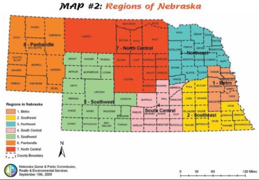
Source: Nebraska Game and Parks Commission
River in north-central Nebraska. Fort Niobrara NWR was established by Executive Order in January, 1912 as a “preserve and breeding ground for native birds.” Its purpose was expanded later that same year to include the preservation of bison and elk herds representative of those that once roamed the Great Plains. Furthermore, the unusual, and unique assemblage of plant communities currently present at the Refuge (Sandhills Prairie, Mixed Prairie, Rocky Mountain Coniferous Forest, Eastern Deciduous Forest, and Northern Boreal Forest) support a rich diversity of wildlife generally unchanged from historic times. Under the Wilderness Act of 1964, a
4,635-acre portion of Fort Niobrara was designated a Wilderness Area in 1976; a portion of the Niobrara River through the Refuge was designated a National Canoe Trail by Congress in 1982; and, in 1991, a 76 mile stretch of the Niobrara River including the River through this Refuge was designated Scenic under the National Wild and Scenic Rivers Act. (Fort Niobrara Comprehensive Conservation Plan - September 1999)
Fort Niobrara National Wildlife Refuge is managed as part of the Fort Niobrara/Valentine National Wildlife Refuge Complex. Included in this complex is the Valentine and John W. and Louise Seier National Wildlife Refuges. The Refuge Complex headquarters is located at: Fort Niobrara National Wildlife Refuge, 39983, Refuge Road, Valentine, Nebraska 69201.
Valentine National Wildlife Refuge was created by Executive Order 7142 in 1935. The facility is managed as part of the Fort Niobrara/Valentine National Wildlife Refuge Complex. A National Wildlife Refuge Complex is an administrative grouping of two or more refuges, wildlife management areas or other refuge conservation areas that are primarily managed from a central office location. Refuges are grouped into a complex structure because they occur in a similar ecological region, such as a watershed or specific habitat type, and have a related purpose and management needs. Typically, a project leader or complex manager oversees the general management of all refuges within the complex and refuge managers are responsible for operations at specific refuges. Supporting staff, composed of administrative, law enforcement, refuge manager, biological, fire, visitor services, and maintenance professionals, are centrally located and support all refuges within the complex.
Prior to the creation of the wildlife refuge, the lands were grazed by livestock owned by Cherry County ranchers. Since the refuge was established, livestock grazing has been significantly reduced as the Service has prioritized bison and wildlife management. This has harmed the County’s ability to protect the backbone of its agriculture economic engine, making it more difficult for the County to support the essential services that allow hunters, fisherman, and other recreationist to enjoy the refuge and other recreational areas within CherryCounty.
It is because of this experience the County opposes the additional expansion of the refuge system through federal or state land acquisitions, or by conservation easements held by government or non-profit entities without prior Countyapproval.
Managed by the United States Forest Service Located south of Nenzel in Cherry County, the Samuel R. McKelvie National Forest is a 116,000acre area representing the unique Nebraska Sandhills. The area is used by the public for hunting, fishing, horseback riding, camping, and bird watching. There is one small campground located on the southwestern edge of the forest, Steer Creek Campground, which has 23 campsites, 8 horse corrals, potable water, and the 1-mile Blue Jay hikingtrail.
The Niobrara River Canoe Launch is a day use site on the Niobrara River for launching small watercraft. Fishing is available in the nearby Merritt Reservoir. The Lord Lakes wetland complex has been recognized for its outstanding fishing. Source: https://www.fs.usda.gov/recarea/ nebraska/recreation/ hiking/recarea/? recid=30324&actid=50
Managed by the U. S. National Park Service and Niobrara Council
The 76 miles of the Niobrara National Scenic River was set aside by Congress in 1991 to preserve "outstandingly remarkable values" including Fish and Wildlife, Scenery, Fossil Resources, Geology, and Recreation. The river was designated by Backpacker magazine as one of the 10 best rivers for canoeing in the United States.
Along the National Scenic River are numerous waterfalls that empty into the river from the surrounding cliff and canyon walls; the highest one is Smith Falls, which drops almost 63 feet (19 m) into the river valley. There are short sections of Class I and II rapids on the river, and several locations further downstream require a portage around the rapids. The westernmost 26 miles (40 km) of the Scenic River section, from the Fort Niobrara National Wildlife Refuge (just east of Valentine) to the Rocky Ford portage, offer outstanding canoeing, kayaking,and tubing opportunities.
The river has retained its world-renowned qualities largely because it has been properly managed and conserved for generations by the private landowners that surround its banks. It has been this stewardship of the river that attracted national attention and led to its Wild and Scenic designation. The landowners remain the rivers most important conservationists. Access to many resources.
Around 75,000 people visit the river annually, with the months of June through August being the busiest. Water levels decline slightly in late summer, but the river can still be enjoyed by canoe, kayak, and inner tube. To reach the first public access on the Scenic River is on Nebraska Highway 12, northeast of Valentine.
Considered an extraordinary example of a Great Plains river, the Niobrara is home to over 500 plant species many at or beyond their usual range, including many not otherwise naturally found within several hundred miles. These species include birch, ponderosa pine and a rare hybrid aspen (quaking X bigtooth). Species from six different vegetation communities can be found in proximity. Northern boreal forest types occur on north facing slopes where shade and abundant ground water create cooler microclimates. Species growing here include paper birch, aspen, ferns and club mosses. Rocky Mountain forest plants include ponderosa pine, serviceberry, and horizontal juniper. Eastern deciduous forests grow on the moist bottom lands and islands of the Niobrara. They include American elm, basswood, cottonwood, green ash, bur oak, hackberry and box elder. Three types of prairie are found in the river valley, displaying a botanical transition between among the eastern tallgrass prairie, the Sandhills mixed-grass prairie, and Northern Mixed-grass prairie. Mule deer, beaver, mink, pronghorn, river otter and even bison can be found in the area. Approximately 300 bison and a few dozen elk are protected in the 19,000 acre (77km2) Fort Niobrara National Wildlife Refuge, whichis located along the river.
In the Niobrara river, minnows such as sand shiners, red shiners and flathead chubs search for their food of aquatic insects near streambank margins. Larger fish, such as rainbow and brown trout,prefer cooler, clear water where springbranch canyon tributaries enter the river. Channel catfish, a popular game fish, prefer deeper waters or cover during the day and feed at night in the riffles. Softshell, snapping or
painted turtles may be found sunning on logs in summer.
The scenic river is spanned by 15 bridges, including six which are listed on the National Register of Historic Places.Source:https://en.wikipedia.org/wiki/ Niobrara_National_Scenic_River
ARTHUR BOWRING RANCH STATE HISTORICAL PARK
See Chapter 5 of this Plan.
Scenic Smith Falls State Park is home to Nebraska’s highest waterfall, also called Smith Falls. Smith Falls and the facilities are actually on private property with a 99-year lease given to the Nebraska Game and Parks Commission. The state park is a popular destination for campers, as well as canoers, kayakers, tubers and others who visit the area to experience the beautiful Niobrara River, a National Scenic River. Many outfitters use the park as a takeout spot, which make it a convenient camping site for those planning topaddle or float the river.
Smith Falls is named for Frederic Smith, who filed the first homestead patent on the land that encompasses the falls. The site became a state park in 1992. Not only is the land home to the beautiful falls, it is also an area of biological significance where several ice age species can still be found. Source: http://outdoornebraska.gov/ smithfalls/
Snake River Falls tumbles over a 54 foot wide ledge and flows 12 miles to the Niobrara River. When the Snake River is full, it is the largest waterfall in Nebraska by volume. The waterfall is located 23 miles southwest of Valentine on Highway 97. Only 3 miles from Merritt Reservoir. It is privately owned, but open for viewing.
MERRITT DAM
Located in a picturesque valley of the Snake River 26 miles southwest of Valentine. The facility is managed by the Nebraska Games and Parks Commission. Merritt Reservoir offers some of Nebraska’s best fishing, along with boating and camping.Itis a deep lake with excellent inflow from the Snake River and Boardman Creek. Merritt Dam has been designated as a dark skyarea.
The Reservoir provides water to irrigate approximately34,500 acres of farmland in the area.
The Ainsworth Canal originates at Merritt Dam outlet works and extends eastward through the Sandhills to the project lands. The canal is concrete lined for its entire length to minimize seepage losses in the sandy soils it traverses, is 52.8 miles long, and has an initial capacity of 580 cubic feet per second.
The lateral system which delivers the water to the project lands has a total length of 169.7 miles and the initial capacities range from 530 to 4 cubic feet per second. Five miles of surface water disposal drains and several disposal ponding areas have been constructed. Other surface water disposal and subsurface drainage facilities will be constructed as necessary.
There are 230 named natural lakes in Cherry County.
There are three golf courses serving the Cherry County area. One is The Prairie Club and the second is Fredrick Peak Golf Club; while the final is CapRock Golf Course.
The Prairie Club is a membership club containing two 18-hole courses (Par 73) called the Dunes Course and the Pines Course. The third course, the Horse Course, is a 10-hole Par 3 course. The Prairie Club is located south of Valentine on Highway97.
The Fredrick Peak Golf Club is located outside of Valentine. The course is a 10-hole course with driving range facilities. The golf club is open to the public.The clubhouse serves food and beverages.
CapRock Ranch is an 18-hole, private golf course tracing the caprock cliffs of the Snake River Canyon, in the Sandhills of Northwest Nebraska. Located south of Valentine on highway 97. Source: https://www.caprockranch.com/
Parks and Recreation Goal 1
In order to ensure the continued robust recreation and tourism activities, and the health, safety, welfare and economic prosperity of the citizens, the County requires that all state and federal agencies coordinate the management of the recreation and conservation lands with the County’s Comprehensive Plan, Natural Resource Plan and Zoning Regulations.
Parks and Recreation Goal 2
Coordinate with federal and state agencies to increase multiple recreation uses in Cherry County including on all federal agency administered lands located within its boundaries. These should include high quality recreational opportunities and experiences at developed and undeveloped recreation sites by allowing historic uses and access while maintaining existing amenities, and by providing new recreation sites for the public's enjoyment.
Coordinate with federal and state agencies to increase public access opportunities in both motorized and non-motorized settings. Recognize that multiple recreation uses are mandated by the multiple use concept and that adequate outdoor recreation resources should be provided on all federal and state agency's administered lands and waterways.
Parks and Recreation Goal 3
Cherry County will continue to work closely with different entities within the jurisdiction of the County, including the communities and Natural Resource Districts to maintain and enhance the existing parks, camps,riverfront, and lakes.
Parks and Recreation Policies and Strategies
PR-3.1 The County should continue promoting the area’srecreational destinations.
PR-3.2 The County should continue to promote local Agri-tourism.
Parks and Recreation Goal 4
There shall be no additional designations of Wild and Scenic Rivers in Cherry County without County approval, as the existing rivers, segments or tributaries do not meet the standards for designation.


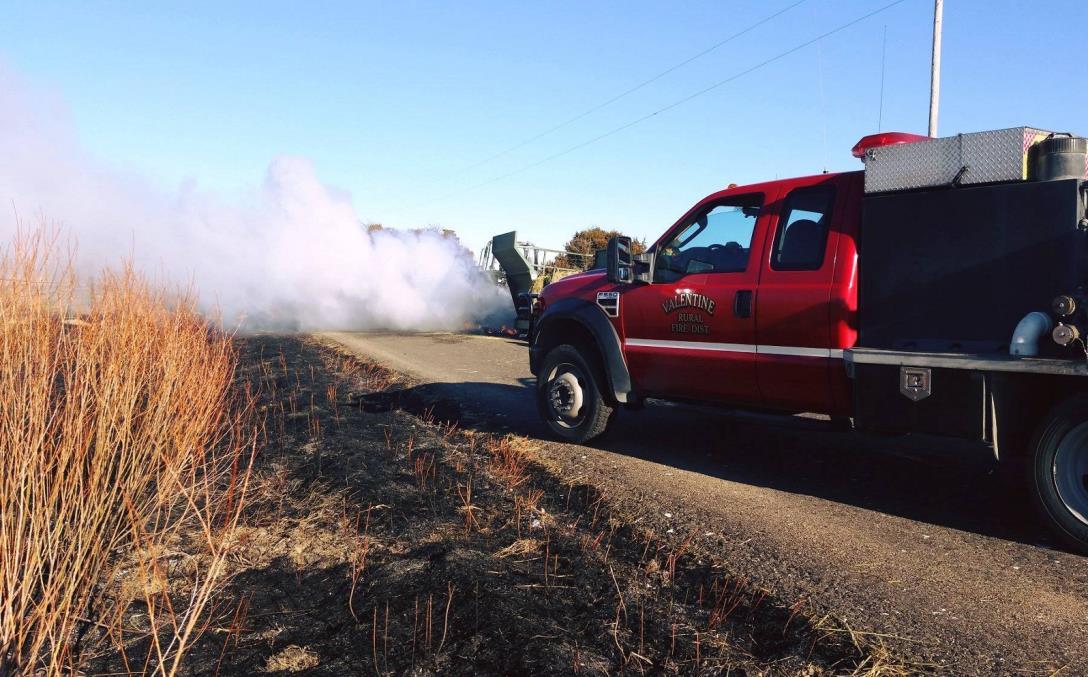
FIRE AND RESCUE

Fire and rescue in Cherry County is handled through 14 different departments/agencies:
• Barley
• Cody
• Gordon
• Hyannis
• Kilgore
• Merriman
• Mid-Cherry
• Mullen
• Purdum
• Thedford
• US Fish and Wildlife
• US Forest Service
• Valentine
• Wood Lake
Each of the agencies listed above, provide varying levels of fire and rescue service to their respective territories. Detailed information is not provided since the type and age of equipment can varyannually.
A map in the Appendices shows the location and boundaries of the 14 different agencies providing fire protection in Cherry County.
VALENTINE VOLUNTEER FIRE DEPARTMENT
Valentine Fire Departments provide fire protection and emergency response services to the Valentine, NE community with a mission to prevent the loss of life and property. In addition to responding to calls for fire suppression, Valentine Fire Departments respond to medical emergencies, incidents involving hazardous materials, rescue calls, and motor vehicle or other accidents. Source: https:// www.countyoffice.org/valentine-ne-firedepartments/
BARLEY RURAL FIRE DEPARTMENT
Barley Rural Fire Department is located approximately in the middle of Cherry County. The fire district covers approximately 156 square miles of CherryCounty.
CODY VOLUNTEER FIRE DEPARTMENT
The Cody Volunteer Fire Department is located in Cody. The district is in northwest Cherry County. The fire district covers approximately231 square miles.
GORDON VOLUNTEER FIRE DEPARTMENT
The Gordon Volunteer Fire Department is based in Gordon, within Sheridan County. The district covers approximately674 square miles of Cherry County.
The Hyannis Volunteer Fire Department is based in Hyannis, within Grant County. The district covers approximately457 square miles of Cherry County.
The Kilgore Volunteer Fire Department is based in Kilgore, in north-central Cherry County. The district covers approximately 190 square miles of Cherry County.
The Merriman Volunteer Fire Department is based in Merriman, in northwest Cherry County. The district covers approximately 750 square miles of Cherry County.
MID-CHERRY VOLUNTEER FIRE DEPARTMENT
The Mid-Cherry Volunteer Fire Department is based in central Cherry County. The district covers approximately336 square miles of Cherry County.
MULLEN VOLUNTEER FIRE DEPARTMENT
Mullen Volunteer Fire Department is based in Mullen within Hooker County. The fire district covers approximately719 square miles of Cherry County.
PURDUM VOLUNTEER FIRE DEPARTMENT
Purdum Volunteer Fire Department is based in Blaine County, southeast of Cherry County. The fire district covers approximately 390 square miles of CherryCounty.
THEDFORD VOLUNTEER FIRE DEPARTMENT
Thedford Volunteer Fire Department is based in Thedford in Thomas County, south of Cherry County. The fire district covers approximately 500 square miles of CherryCounty.
US FISH AND WILDLIFE FIRE DEPARTMENT
The US Fish and Wildlife Fire Department is a Federal agency and covers the two different refuges located in Cherry County. US Fish and Wildlife is responsible for approximately 128 square miles of CherryCounty.
US FOREST SERVICE FIRE DEPARTMENT
The US Forest Service Fire Department is a Federal agency and covers the National Forest lands located in Cherry County. The Forest Service is responsible for approximately 151 square miles of CherryCounty.
WOOD LAKE VOLUNTEER FIRE DEPARTMENT
Wood Lake Volunteer Fire Department is based in Wood Lake, in eastern Cherry County. The fire district covers approximately 450 square miles of CherryCounty.
CHERRY COUNTY SHERIFF’S DEPARTMENT
Cherry County is served by the Cherry County Sheriff’s Department, which provides policing services to a majority of the county as well as support and operation of the county courts. The Cherry County Jail is run by the County Commissioners and a jail administrator.
The following are other law enforcement agencies in Cherry County:
• Valentine Police Department
• US Fish and Wildlife
• US ForestryService
• Nebraska Game & Parks Game Warden
Based upon data from the Nebraska Commission on Law Enforcement and Criminal Justice, the Cherry County Sheriff’s Department had five fulltime sworn officers in 2016 and 2018. Table 7.1 shows the sworn officers for the past three years. When examining the number of sworn officers per 1,000 people, the Cherry County Sheriff’s Department had an average of 1.6 sworn officers per 1,000 people from 2016 to 2018. Table 7.1 also shows the Valentine Police Department has maintained between five and six sworn officers for the same period.
Source: Nebraska Commission on Law Enforcement and Criminal Justice 2016 through 2018
The ratio of law enforcement officers per 1,000 persons in the population for any given area is influenced by many factors. The determination of law enforcement strength for a certain area is based on such factors as population density, size and character of the county, geographic location and other conditions existing in the area. The data indicate Cherry County has been maintaining a ratio of 1.6 sworn officers per 1,000 people over a period of time; apparently this is a good balance for Cherry County. Table 7.1 also shows the number of sworn officers and officers per 1,000 persons in the surrounding counties.
Cherry County Emergency Management is locally operated by Cherry County. Emergency Management has a local Manager located in Valentine. However, the county’s office works directly under the state agency, Nebraska Emergency Management Agency (NEMA). The local offices were created under the Nebraska EmergencyManagement Act of 1996.
The Nebraska Emergency Management Agency (NEMA) is part of the Military Department. The state's Adjutant General serves as the director of the agency as well as the commanding officer of the Army National Guard and the Air National Guard. The three units comprise the Military Department.
Originally, the agency was located in a bunker built in the 1960s during the height of the Cold War. It was intended to serve as Nebraska's government headquarters if nuclear confrontation was likely. In 2012, the agency headquarters was relocated to the Joint Force Headquarters, on the Nebraska National Guard base in Lincoln. NEMA is a small agency with less than 40 full-time and part-time employees. Day-to-day operations are managed bythe assistant director.
Emergency management in the United States has been divided into four phases: preparedness, response, recovery, and mitigation. Even with the emphasis on terrorism since the 9/11 attacks, emergency management's role has not changed a great deal. Nebraska must still deal with a host of hazards,both natural and man-made.
During the preparedness phase, NEMA monitors the situation across the state. This is accomplished by using a duty officer system; state, National Weather Service and North American Warning and Alert System (NAWAS); local emergency management organizations, police and fire departments across the state andthe general public.
A member of NEMA staff serves as the duty officer on a rotational basis taking calls for a host of incidents in addition to severe weather such as tornadoes, floods and blizzards. A terrorist attack would be handled in the same manner as a tornado strike or flood.
During the preparedness phase, the agency coordinates the state Radiological Emergency Preparedness Program (REP), which develops emergency plans for the two nuclear power plants – Cooper and Ft. Calhoun Nuclear Stations.
The agency also monitors low-level and high-level radiological material shipments, which traverse the state by highway and railway. Any abnormality can trigger a call to the duty officer and alert the rest of Nebraska government.
NEMA conducts an extensive training program for emergency managers and first responders, such as police, fire and emergency medical personnel. The training classes cover a wide range of topics, including counter terrorism, hazardous materials, radiological emergency, public information and incident management. Classes, schedules and other information are listed on NEMA's training page.
An important part of preparedness is the development of state and local emergency operations plans, which NEMA coordinates. The agency has also developed an emergency operations exercise program that assists local jurisdictions in exercising their emergency plans.
Each year, once in the spring and again in the fall, the agency conducts public awareness campaigns. The severe weather awareness campaign tests the state's emergency systems in advance of the spring thunderstorm season and the winter weather awareness campaign does the same before winter. Both are sponsored by NEMA and the National Weather Service.
In the event of an emergency anywhere in the state, the local jurisdictions are responsible for first response to the emergency. If local resources are inadequate to deal with the situation, the local political leader declares an emergency and requests state assistance.
Normally, the agency would be aware of the developing situation and would have alerted the governor's office and other state agencies. NEMA could also activate the State Emergency Operations Center (SEOC) located in the agency headquarters. The SEOC becomes the center for any state response. Depending upon the nature of the emergency, state teams can be dispatched to the disaster area.
If deemed necessary the Federal Emergency Management Agency' s (FEMA) Region VII office, which is located in Kansas City, can be alerted. They, in turn, can notify FEMA National in Washington,D.C.
Upon the advice of the agency director, the governor can proclaim a state emergency and sign a declaration. This declaration formalizes the state response and places all the state's resources at the disposal of the adjutant general. This can involve the National Guard, State Patrol, Department of Transportation, Game and Parks Commission, Department on Aging, Health and Human Resources or any other agency that can be of assistance.
The formal declaration process also allows the adjutant general to use money in the governor's Emergency Fund to pay for the disaster costs. This fund, which was created and is maintained by the Legislature,usuallyis kept at around $1 million.
If the governor determines state resources are not sufficient to deal with the emergency, a federal disaster declaration can be requested. The issuance of a Presidential Disaster Declaration means all the resources of the federal government can be brought tobear on the emergency.
Under a Presidential Disaster Declaration, NEMA and FEMA coordinate state and federal activities in a Joint Field Office. The two disburse recovery funds for two types of federal disasters. A Presidential Disaster Declaration can be for public assistance, individual assistance or both.
Public assistance is used to help local and state governments recover their disaster expenses. Public assistance is used to pay for roads, bridges, public buildings and other facilities damaged in the disaster and to pay for costs such as the National Guard, police, fire and public works employee salaries and other costs. Normally, the Federal Government pays 75 percent of all eligible public costs. Traditionally, the state and local governments equallysplit the remaining 25 percent.
Individual assistance is provided to the survivors of the disaster. Individual assistance can come in the form of low interest loans both to families and businesses, or individual family grants to pay for losses to families or businesses that are not eligible for loans.
Following a federally-declared disaster, the state receives funding assistance for hazard mitigation. This can amount to substantial sums of money, because 15 percent of the total federal share of the disaster is earmarked for mitigation. Hazard mitigation is designed to lessen or mitigate the impacts of future disasters.
For example, hazard mitigation for flooding might mean the buyout of flood-prone structures in the disaster area, or it might involve raising structures above the 100-year flood level. In the case of tornadoes, mitigation might involve better warning systems or structural improvements. The state and federal governments must agree to whatever mitigation projects that are designed. Source: https://nema.nebraska.gov/overview/nemaoverview
Public Safety Goal 1
The goal of Cherry County is to maintain fire protection, rescue and ambulance programs by exploring programs and alternative services to ensure optimum service levels and public costs.
Public Safety Policies and Strategies
PS-1.1 The different fire and rescue organizations and the county should continue to work to maintain qualityequipment levels.
PS-1.2 The fire departments should continue to expand fire safety education and prevention throughout the county.
Public Safety Goal 2
Cherry County should work collectively to address and minimize wildfires within the county.
Public Safety Policies and Strategies
PS–2.1 Continuallytrain for wildfire conditions.
PS-2.2 Continue to work with state and federal entities on land management in order to prevent wildfires.
Public Safety Goal 3
The County will continue positive planning for law enforcement in Cherry County.
Public Safety Policies and Strategies
PS–3.1 The Countywill continue urging consultation, cooperation and coordination between federal and state agencies and local law enforcement personnel.
PS-3.2 The County will provide to protect all Cherry County citizens, private property rights, and natural resources located within the county while complying with Nebraska laws, the Nebraska Constitution, county ordinances, Federal laws and The United States Constitution.
Public Safety Goal 4
The goal of Cherry County is to maintain quality law enforcement throughout the county.
Public Safety Policies and Strategies
PS-4.1 Continue to identify specific ways to work cooperatively with the County Sheriff regarding protection inthe County.
PS-4.2 Continue to support minimum standards regarding equipment used by law enforcement.
Public Safety Goal 5
The goal of Cherry County is to maintain regulations to protect the general health and safety of all residents.
Public Safety Policies and Strategies
PS-5.1 Establish regulations protecting the county residents from the secondary effects of adult entertainment.


TELEPHONE SERVICES
The primary telephone providers in Cherry County include CenturyLink and Great Plains Communication.
RADIO STATIONS
There are multiple stations available to listeners in CherryCounty. Local stations (Valentine)are: KMBV 90.7 FM, KKNL 89.3 FM, KSDZ/KDJL 99.5, and KVSH 940 AM.
TELEVISION STATIONS
Presently there are no local television stations located in Cherry County. The over the air stations serving the area originate out of South Dakota, Colorado and Nebraska.
High speed Internet service in Cherry County is primarily provided by CenturyLink and Great Plains Communications. There are various other small providers in the area.
All of the mainstream cellular providers have a presence in Cherry County. Viaero, Verizon, and US Cellular have a local office in Valentine.
The residents of Cherry County are served locally by the Valentine Midland News which is a weekly paper. Daily news is provided by the Omaha World Herald, Scottsbluff Star-Herald, and the North Platte Telegraph.
Listed below are other newspapers with weekly circulation withinthe Cherry Countyarea:
• Hooker CountyTribune in Mullen
• Thomas CountyHerald in Thedford
• Sheridan CountyJournal-Star in Gordon
• Grant CountyNews
The sanitary waste in the rural parts of Cherry County is handled via individual septic systems. The level and complexity of these systems varies greatly throughout Cherry County due to soil conditions, see Chapter 11: Natural Resources and Soils for more detail.
Sanitary waste within the communities of Cherry County are typically addressed via communitywide collection and treatment systems if available.
Water in Cherry County is supplied by wells drawing groundwater up for consumption or other uses. The unincorporated communities and the farmsteads, and acreages typically have individual wells supplying the needs of the user. However, within some of the primary incorporated communities of the county, the wells are owned and operated by the local government. The local government runs a centralized system.
Sanitation collection in Cherry County is provided byprivate haulers.
Sanitary Improvement Districts in Nebraska are a form of taxation which allows a development group and/or homeowner’s association to establish a special taxing district for purposes of installing or improving infrastructure such as a water system and/or a sanitary sewer collection and treatment system. SID’s may also construct and/or maintain streets within such a district. The creation of an SID is controlled by the District Courts of Nebraska. Cherry Countydoesnot haveanySID’swithinthecounty.
The Nebraska Public Power District provides power to Cherry County retail and wholesale to local public power districts. There are five primary rural public power districts serving Cherry County:
• KBRRural Public Power
• Cherry-Todd Electric Cooperative
• La Creek Electric based in S. Dakota
• Northwest Rural Public Power District
• Panhandle Rural ElectricMembership,and
• Custer Public Power District
KBR Rural Public Power District is a non-profit public utility whose mission is to safely provide customers reliable, high quality and reasonably priced electricity and other energy related products and services. KBR is one of 32 rural electric systems located in Nebraska and one of nearly 1,000 electric systems nationwide. They provide electric service to over 5,400 electric accounts scattered across over 5,000 square miles of service area located in the counties of Brown, Rock, Keya Paha and Cherry in the sandhills of north-central Nebraska.
They are a distribution utility they do not generate electricity. They purchase all of their power from the Nebraska Public Power District through the Nebraska Electric G&T, both headquartered in Columbus, Nebraska.KBR has 17 full-time employees; three working out of our Valentine Outpost, three serving out of the Springview Outpost and the balance headquartered in the general office located in Ainsworth,Nebraska.
KBR is governed by nine elected board members, three from Keya Paha County, three from Rock County, two from Brown County and one from Cherry County. Each board member is elected at the November general election and is elected for a six-year term.
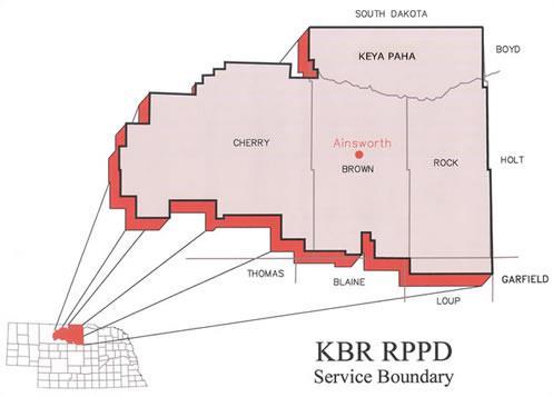
Source:https://kbrpower.com/
Cherry-Todd Electric Cooperative part of a Touchstone Energy Cooperatives. The Touchstone Energy Cooperatives brand represents a nationwide alliance made of more than 750 local, consumer-owned electric cooperatives in 46 states. Touchstone Energycoops collectivelydeliver power and energy solutions to more than 30 million members every day. Electric cooperatives distribute power for 56 percent of the U.S. land mass over 2.4 million miles of power lines.
Electric cooperatives were established to provide electricity to rural America, and now make up the largest electric utility network in the nation. Touchstone Energy is the national brand identity for that network.
Touchstone Energy co-ops are owned by the members they serve and are committed to providing reliable electricity at the lowest price possible. In short, co-ops “look out” for the members they serve. Sources: http://www.cherrytodd.com/
Lacreek Electric Association, Inc. was incorporated in 1948. It is headquartered at Martin, along the north edge of the Great Sand Hill Plains in southern South Dakota. LEA is a rural electric cooperative serving more than 4,000 members in six counties across 5,174 square miles of south central South Dakota and northern Nebraska.
Source:http://www.nrppd.com/
Northwest Rural Public Power District is located in the northern part of the Nebraska Panhandle, and is a Touchstone Energy partner. They provide electricity and many other quality products and services to customers in Northwest Nebraska. The service area covers the Oglala National Grasslands and the national forest and dryland wheat areas in the West, to the Pine Ridge Indian Reservation, pine trees and rugged rock terrain in the North, to the sandhills and cattle ranches to the East and to the irrigated farmlandtotheSouth.
The main office is located in Hay Springs, a town of 650 population with a high school, grade school, medical clinic, parks, swimming pool and much more. Ahospital and four-year college are within 20 minutes of HaySprings.
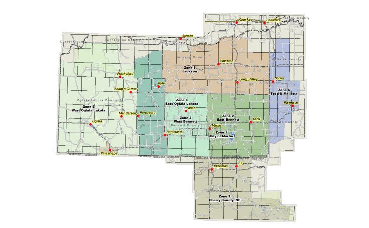
Source:lacreek.com
PREMA is a local rural electric cooperative. Articles of Incorporation were filed in the offices of the Secretary of State and County Clerk of Box Butte County on April 5th, 1945, organizing Panhandle Rural Electric Membership Association (PREMA). The goal of the organization being, "to provide electric service to every farm and ranch within our area." For more than 70 years we continue to provide power to all or parts of 11 western Nebraska counties which include; Arthur, Box Butte, Cherry, Dawes, Garden, Grant, Hooker, McPherson, Morrill, Sioux and Sheridan. Sources: http:// www.prema.coop

Source:https://www.custerpower.com
CUSTER PUBLIC POWER DISTRICT
Custer Public Power District believes community ties are what sets “Public Power” apart from other utility services. Public Power is owned by the customers we serve. Whether it is a residential, commercial, or agricultural account, that customer-owner has a voice. The Board of Directors are voted to the Custer Public Power District’s Board of Directors to represent the customer-owner. Custer Public Power District strives to provide the most reliable, affordable, and personal electrical service available. Providing “Public Power” to the communities, serving rural Nebraska, and powering the “Good Life”. Sources: https:// www.custerpower.com
ELECTRICAL DISTRIBUTION
The overall distribution systems are in good condition. The systems are owned and operated by each of the power districts. The distribution systems not only supply power throughout Cherry County but are the foundation for power transmitted to other customers in Nebraska.
Nebraska law requires that new or updated Comprehensive Plans include an energy element that “Assesses energy infrastructure and energy use by sector, including residential, commercial, and industrial sectors; evaluates utilization of renewable energy sources; and promotes energy conservation measures that benefit the community.” This section
addresses these issues by analyzing the energy use by residential, commercial, industrial and other users, and examining the different types of energy sources that are utilized by these different sectors, and available for future needs.
Within Cherry County, residential uses are provided a number of options for both power and heating and cooling. These include electrical power (both fossil fuel and renewable resources), oil, propane, and wood. The most dominant of the energy sources available and used by the residents of Cherry County is electricity produced from both fossil fuels and renewable resources. The use of oil, propane and wood will be found typically as heating sources during the winter months. The type of fuel used will depend a great deal on where a residence is located within the county. Residents located within the more urbanized parts of Cherry County are more likely to have electrical furnaces. Propane and wood stoves are most likely found in the rural parts of the county where other sources are not always available.
Cherry County’s commercial uses also have a number of options for both power and heating and cooling. These include electrical power (both fossil fuel and renewable resources), propane, oil and wood. The type of energy source is very dependent upon the specific commercial use and the facilities employed to house the use. The most dominant of the energy sources available is electricity produced from both fossil fuels and renewable resources. Similar to residential uses, the use of oil, propane and wood will be found typicallyas heating sources during the winter months. The type of fuel used will depend a great deal on the type of commercial use and the construction of the building(s)involved. The location of the commercial uses will also dictate, similar to residential uses, what type of heating fuels are used. However, in commercial uses such as repair garages and other uses in larger metal buildings, they may be dependent upon recycling used motor oils toheattheir facilities.
Cherry County’s industrial uses will be very similar to those discussed within the commercial section. However, in some cases, diesel fuel can play a role in both power generation and heating and cooling.
There are other energy sources advancing in technology that use wind, solar, water, geothermal and methane gas as an energy source. While Cherry County encourages the use of technological advances to improve and support the agriculture industry, this is done while carefully considering the long-term impact such systems may have on the unique Sandhills landscape.
Large-scale wind and solar farms in particular have a significant footprint on the landscape, requiring substantial infrastructure for roads, turbine and panel siting,and the required transmission lines.
Currently, the Valentine Wind LLC project consists of one 1.7 MW turbine to supply power to the city of Valentine.
In May 2007, Nebraska established an exemption from the sales and use tax imposed on the gross receipts from the sale, lease, or rental of personal property for use in a community-based energy development (C-BED) project. The Tax Commissioner is required to establish filing requirements to claim the exemption. In April 2008, L.B. 916 made several amendments to this incentive, including: (1) clarified C-BED ownership criteria to recognize ownership by partnerships, cooperatives and other pass-through entities; (2) clarified that the restriction on power purchase agreement payments should be calculated according to gross and not net receipts; (3) added language detailing the review authority of the Tax Commissioner and recovery of exempted taxes; and (4) defined local payments to include lease payments, easement payments, and real and personal property tax receipts from a C-BED project.
A C-BED project is defined as a new wind energy project that meets one of the following ownership conditions:
• For a C-BED project that consists of more than two turbines, the project is owned by qualified owners with no single qualified owner owning more than 15% of the project and with at least 33% of the power purchase agreement payments flowing to the qualified owner or owners or local community; or
• For a C-BED project that consists of one or two turbines, the project is owned by one or more qualified owners with at least 33% of the power purchase agreement payments flowing to a qualified owner or local community.
In addition, a resolution of support for the project must be adopted by the county board of each countyin whichthe C-BED project is tobe located.
Aqualified C-BED project owner means:
• a Nebraska resident;
• a limited liability company that is organized under the Limited Liability Company Act and that is entirely made up of members who are Nebraska residents;
• a Nebraska nonprofit corporation;
• An electric supplier(s), subject to certain limitations for a single C-BED project.
In separate legislation (LB 629), also enacted in May 2007, Nebraska established the Rural CommunityBased Energy Development Act to authorize and encourage electric utilities to enter into power purchase agreements with C-BED project developers.
Solar energy has been around for decades and it last hit a high in popularity in the 1970’s. However, today’s solar energy design is much more efficient and aesthetically pleasing. Some of the aesthetic improvementshave todowith thefactthat today’s systems are not as bulky as their ancestors. Today, solar is being used much like wind turbines, on a small-scale level (home or business) or a much grander level (solar farms). Small-scale levels are generallycompatible with Cherry County.
Geothermal energy is typically utilized through a process where a series of pipes are lowered into vertical cores called heat-sink wells. The pipes carry a highly conductive fluid that either is heated or cooled by the constant temperature of the ground. The resulting heat exchange is then transferred back into the heating and cooling system of a home or other structure. This is called a geothermal heat exchange system or ground source heat pump.
The use of methane to generate electricity is becoming more cost-effective to use in Nebraska. Methane electrical generation can be accomplished through the use of a methane digester which takes the raw gas, naturally generated from some form of decomposing material, and converts the gas into electrical power.
There have been some attempts to take the methane generated from animal manure and convert it into electricity; most have been successful but were costly to develop. Another approach to methane electrical generation is to tap into the methane being generated from a solid waste landfill; instead of burning off the methane, it can be piped into a methane convertor and generated into electricity for operating a manufacturing plant or placed on the overall grid for distribution.
Methane convertors make use of unwanted gases and are able to produce a viable product. As long as humans need to throw garbage into a landfill or the production of livestock is required, there will be a source of methane to tap for electrical generation.
LB 436, signed in May 2009, established statewide net metering rules for all electric utilities in Nebraska. The rules apply to electricity generating facilities which use solar, methane, wind, biomass, hydropower or geothermal energy, and have a rated capacity at or below 25 kilowatts (kW). Electricity produced by a qualified renewable energy system during a month shall be used to offset any kilowatt-hours (kWh) consumed at the premisesduring the month.
Any excess generation produced by the system during the month will be credited at the utility's avoided cost rate for that month and carried forward to the next billing period. Any excess remaining at the end of an annualized period will be paid out to the customer. Customers retain all renewable energy credits (RECs) associated with the electricity their system generates. Utilities are required to offer net metering until the aggregate generating capacity of all customer-generators equals one percent of the utility's average monthly peak demand for that year.
Nebraska's solar and wind easement provisions allow property owners to create binding solar and wind easements for the purpose of protecting and maintaining proper access to sunlight and wind. Originally designed only to apply to solar, the laws were revised in March 1997 (LB 140) to include wind. Counties and municipalities are permitted to develop regulations, or development plans protecting access to solar and wind energy resources if they choose to do so. Local governing bodies may also grant zoning variances to solar and wind energy systems that would be restricted under existing regulations, so long as the variance is not substantiallydetrimentaltothe public good.
LB 568, enacted in May 2009, made some revisions to the law and added additional provisions to govern the establishment and termination of wind agreements. Specifically, the bill provides that the initial term of a wind agreement may not exceed forty years. Additionally, a wind agreement will terminate if development has not commenced within ten years of the effective date of the wind agreement. If all parties involved agree to extend this period, however, the agreement may be extended.


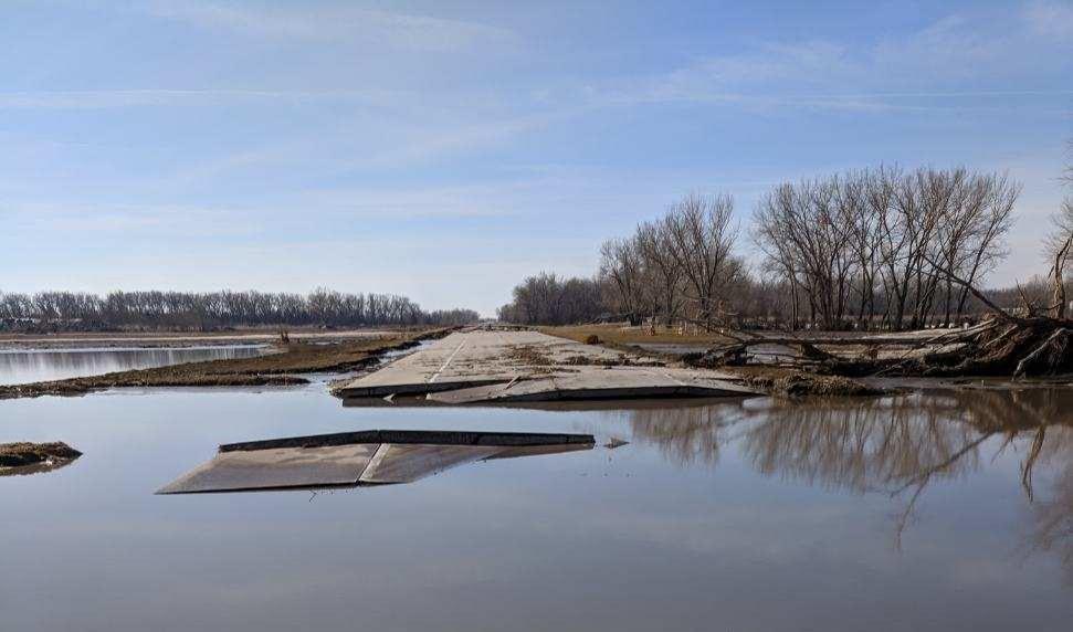


This Chapter of the Cherry County Comprehensive Plan contains the description of specific hazards within the planning area. Good planning would dictate the need to include such issues as Hazards within the Comprehensive Plan. The information found in this Chapter has been taken from the current Hazard Mitigation Plan written for the counties of Boyd, Brown, Cherry, Keya Paha and Rock through the 2021 Region 24 Emergency Management Area. The discussion herein will be focused on those with a land use impact and only for Cherry County.
Since 1967 Cherry County has been directly involved in 10 Presidential Disaster Declarations including: floods, ice jams, tornadoes, severe storms, COVID-19, and severe winter storms. The most recent (two declarations) was during the development of this Comprehensive Plan, COVID19.
One of the key items within the hazard mitigation plan is a risk assessment for the future. The assessment is based upon the type of hazard event and likelihood of it occurring again inthe future.
The type of hazards assessed are:
• Ag Diseases
• Dam Failure
• Drought
• Earthquakes
• Expansive Soils
• Extreme Heat
• Flooding (Riverine and Flash)
• Landslides
• Levee Failure
• Severe Thunderstorms (Thunderstorm and Lighting)
• Hail (Hailstorm)
• Severe Winter Storms (Severe Winter Storms and Extreme Cold)
• Sink Holes
• Tornados
• High Winds (Windstorms)
• Wildfires
• Civil Disorder
• Fixed Site Hazards (Chemical and Radiological)
• Terrorism
• Transportation Incidents (Chemical, Radiological, and Severe Incidents)
• Urban Fire
Section 4 of the Region 24 Hazard Mitigation Plan rates the different hazards and rates them on Historic Occurrence,Probability,and Extent.
Source : Region 24 Hazard Mitigation Plan
inundation of structures (<1% of structures) and roads near major bodies of water. Some evacuations of people may be necessary (<1% of population)
Source : Region 24 Hazard Mitigation Plan
It is critical to monitor hazards, even the ones rated as a Low Risk. The key to successfully addressing these incidents is to follow through with the Goals and Strategies developed to mitigate the issues. Successful mitigation will aid in minimizing the overall loss occurring from anyhazard situation.
Cherry County officials identified food supply, water supply, and school closure having the greatest impact from prolonged power outages. Cherry County receives its power from NPPD, the City of Valentine, KBR REA, Cherry Todd REA, and Panhandle REA. Approximately 10 percent of the county’s power lines are buried. The county indicated that the power supply is sufficient to meet current demand. The county has backup generators at the Justice Center/Courthouse, the hospital,and at the communication towers.
In an effort to mitigate the impacts of this hazard, Cherry County included mitigation actions in the
plan update. These include purchasing additional backup generators for critical facilities, public awareness initiatives, and improvement emergency communications.
The county has 14 fire departments dispersed throughout the county. These fire departments, as well as the Forest Service, regularly conduct education and outreach initiative to mitigate the impacts of wildfire.
Cherry County identified mitigation actions which address this hazard. Included in the plan update are actions such as improved emergency communication and warning sirens, although the main mitigation measure which addresses this hazard will be public education and awareness initiatives. The majority of the County’s offices and critical facilities are located in Valentine, which is a Firewise Community and regularly conducts wildfire mitigation measures, such as debris removal and
other educational initiatives in coordination with the Nebraska Forest Service.
Ten percent of the county’s power lines are buried. The county has safe rooms at their schools, the hospital, and the courthouse. The county does have mobile home parks, which may be particularly vulnerable to these hazards. Valentine is also a Firewise Community. The county has mutual aid agreements with neighboring counties.
Cherry County identified a need to stabilize/anchor fertilizer, fuel, and propone tanks, which will mitigate the impacts of this hazard. Other actions identified during this plan update include developing additional safe room locations and installing weather radios and warning sirens around the county. The Niobrara River Council, which is based in Valentine but operates throughout the county, also identified a safe room project during this plan update.
The county uses surge protection at its critical facilities. There are weather radios at the hospital, at the schools, and at Pineview Nursing Home. The county indicated that is does have education programs which address this hazard.
Actions identified in this plan update include installing weather radios at critical facilities and improving warning sirensaround the county.
Since the completion of the Hazard Mitigation Plan in 2014, there have been three additional declarations in Cherry County, two for COVID-19 and one for severe winter storms, Straight-line Winds,and Flooding.
HAZARD GOALS
The goals of Cherry County and Region 24 are as follows:
Hazard Goal 1
Protect the Health and Safetyof Residents.
Hazard Policies and Strategies
HZ -1.1 Reduce or prevent damage to property or prevent loss of life or serious injury (overall intent of the plan).
Hazard Goal 2
Reduce Future Lossesfrom Hazard Events
Hazard Policies and Strategies
HZ-2.1 Provide protection for existing structures, future development, critical facilities, services, utilities, and trees to the greatest extent possible.
HZ-2.2 Develop hazard specific plans, conduct studies or assessments, and retrofit jurisdiction to mitigate for hazards and minimize their impact.
HZ-2.3 Minimize and control the impact of hazard events through enacting or updating ordinances, permits, laws, or regulations.
Hazard Goal 3
Increase Public Awareness and Educate on the VulnerabilitytoHazards
Hazard Policies and Strategies
HZ-3.1 Develop and provide information to residents and businesses about the types of hazards they are exposed to, what the effects may be, where they occur, and what theycan do to be better prepared.
Hazard Goal 4
Improve Emergency Management Capabilities
Hazard Policies and Strategies
HZ-4.1 Develop or improve Emergency Response Plan and procedures and abilities.
HZ-4.2 Develop or improve Evacuation Plan and procedures.
HZ-4.3 Improve warning systems and ability to communicate to residents and businesses during and following a disaster or emergency.

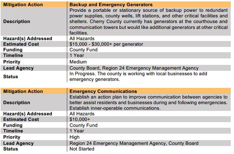
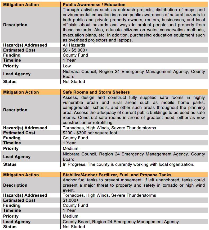

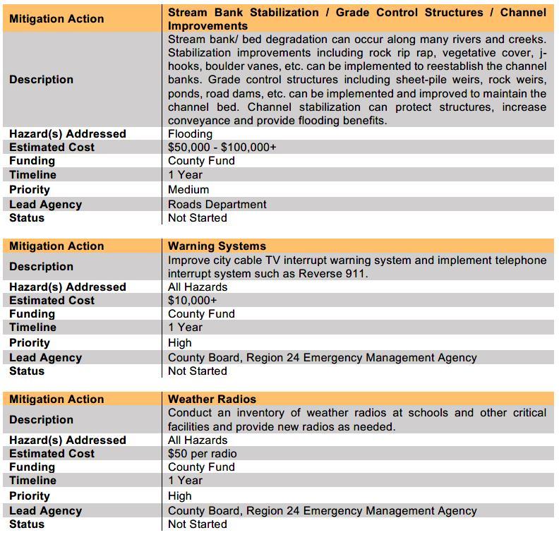

Source : Region 24 Hazard Mitigation Plan


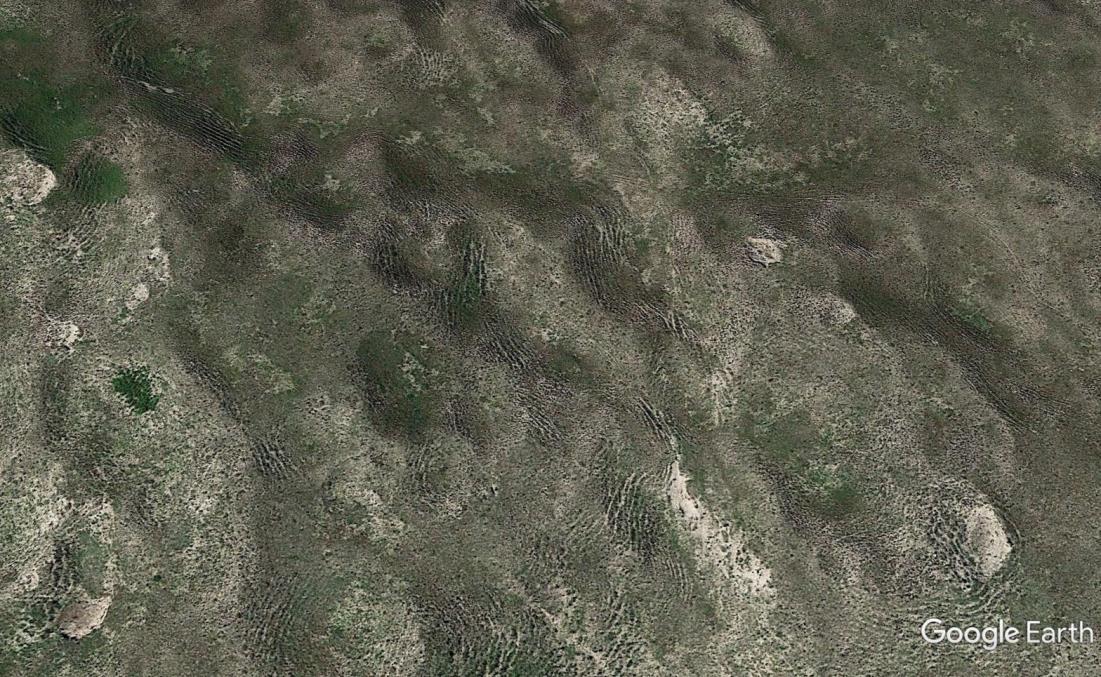

This component of the Cherry County Comprehensive Plan provides a general summary of the environmental and man-made conditions, which are present in the county, and identifies and qualifies the characteristics of each which will directly or indirectly impact future land uses in the county. Much of the information referenced is from the Cherry County Soil Survey conducted by the United States Department of Agriculture – Natural Resources Conservation Service in 2005.
The issues discussed in this chapter include:
• Climate
• Geology
• Relief and Drainage
• Wetlands
• Soil Association
• Prime Farmland
• Soil Limitations
CLIMATE
The climate in Cherry County is characterized by cold winters and long, hot summers. Heavy rains occur mainly in spring and early summer when moist air from the Gulf of Mexico interacts with the drier continental air. Snowfall is fairly frequent in winter, but the snow cover is usually not continuous.
The annual precipitation normally is adequate for wheat,rye, and range grasses.
In winter, the average temperature is 22.3 degrees F and the average daily minimum temperature is 9.3 degrees. The lowest temperature on record, which occurred at Valentine on December 22, 1989, was -39 degrees. In summer, the average temperature is 71.6 degrees and the average daily maximum temperature is 85.8 degrees. The highest temperature, which occurred at Valentine on July 2, 1990,was 114 degrees.
The average annual precipitation is about 18.24 inches. Of this total, about 12.9 inches, or 71 percent, usually falls in May through September. The growing season for most crops falls within this period. The heaviest 1-day rainfall on record was 3.76 inches at Valentine on May 29, 1949. Thunderstorms occur on about 46 days each year, and most occur between Mayand August.
The average seasonal snowfall is 34.1 inches. The greatest snow depth at any one time during the period of record was 22 inches, recorded on December 28, 1987. On the average, 55 days per year have at least 1 inch of snow on the ground. The heaviest 1-day snowfall on record was 18.4 inches,recorded on September 28,1985.
The average relative humidity in midafternoon is about 48 percent. Humidity is higher at night, and the average at dawn is about 77 percent. The sun shines 74 percent of the time possible in summer and 62 percent in winter. The prevailing wind is from the south during the summer and fall and from the north and west during the rest of the year. Average windspeed is highest, about 10 to 11 miles per hour, from March toMay.
The oldest exposed rocks in Cherry County occur in the eastern Niobrara River Valley and consist of brownish to pinkish, pale orange siltstone and silty sandstone. They have been correlated by some geologists with the Rosebud Formation of South Dakota and by others with the upper part of the Brule Formation. These strata are composed predominantly of volcanically derived grains (glass shards and crystals) and were for the most part deposited by the wind. They are upper Oligocene in age (Swinehart and others, 1985).
Overlying the Brule/Rosebud Formation in a few scattered exposures along the central and western Niobrara River Valley are fine grained, silty sandstones of the Arikaree Group. These sandstones contain a lower percentage of glass shards than the Brule or Rosebud Formation and are upper Oligocene to lower Miocene in age.
Sand, sandstone, and siltstone of the Ogallala Group overlie the Brule/Rosebud Formation and Arikaree rocks along the Niobrara River Valley and elsewhere in the county. The outcroppings of the Ogallala sediments have been subdivided into two formations the Valentine Formation and the overlying Ash Hollow Formation. Subsurface correlation of these units has been difficult. Both formations were deposited by streams in a complex set of valleys locally cut deep into underlying strata. A widespread calcium-carbonate-cemented unit, the “Cap Rock,” occurs at the base of the Ash Hollow Formation. Several discrete beds of volcanic ash occur in the Ash Hollow Formation.The Ogallala Group beneath the Sandhills in the southern half of the county is fairly uniform fine and medium sand and lesser amounts of siltstone and coarse sand and gravel (Swinehart and Diffendal, 1990). The Ogallala Group is famous for its accumulation of fossil vertebrates. It is middle to upper Miocene in age.
A few exposures of Pliocene river-deposited sand and gravel occur in southeastern Cherry County.
These have been correlated with the Broadwater Formation of Morrill County. Pleistocene alluvial gravel, sand, and silt are present locally along the Niobrara River Valley. The majority of Cherry County is covered by the fine and medium sand of the Nebraska Sandhills. Recent research indicates that the present dunes were formed during two or more periods of aridity and dune movement in the last 8,000 years (Ahlbrandt and others, 1983). In some interdunes, peat and windblown sand are interbedded to a depth of 25 feet (Loope and others,1995).
The Ogallala Group of the High Plains Aquifer is the main source of ground water in the county (Cronic and others, 1956). Almost all of the water for public and domestic use and much of the water for livestock is obtained from wells.Very little water can be obtained from the Brule/ Rosebud sediments. The Arikaree Group would constitute a source if it were more extensive. The depth to water in areas of the Sandhills varies according to dune height and is generally less than 50 feet in interdune areas. In the tableland areas of the county, water depths generally range from 100 to 200 feet. The saturated thickness of the High Plains Aquifer is typically 300 to 500 feet in the southern half of the county and 100 to 300 feet in the northern half. Water is generally of good quality throughout the county. Total dissolved solids are typically less than 200 milligrams per liter, but higher concentrations are in the northeastern and northwestern parts of the county. Relatively few center-pivot irrigation systems have been installed.
Cherry County is in the northern High Plains of the Great Plains physiographic province. More than 90 percent of the county is covered by sand dunes and interdunes of the prairie-covered Nebraska Sandhills, which make up about 20,000 square miles (Swinehart, 1990). The Niobrara River Valley, extending from west to east across the northern part of the county, and tablelands in the northeast corner and the extreme west-central parts of the countymake up the other major landforms.
The Nebraska Sandhills is by far the largest sand dune area in North America. The sand dunes in Cherry County average about 150 to 250 feet high, 2 to 10 miles long, and one-half mile to 2 miles wide. These large dunes typically have steep south- to southeastern-facing slopes and rolling backslopes. They are separated from each other by nearly level to gently sloping interdunes. Certain areas of the
Sandhills have many shallow lakes and interdunal wetlands. Some of the lakes and the interdunes surrounding them are moderately alkaline or strongly alkaline. Many interdunes have small streams, but drainage networks are poorly developed because the sandy soils allow little runoff. The Snake River, Minnechaduza Creek, and all other tributaries of the Niobrara River and the forks of the Middle Loup River all flow in valleys cut 50 to 200 feet below the level of the interdunes. The North Loup River and its tributaries flow east and southeast. They drain much of the southeastern part of the county, and their valleys are not cut so deeply.
The Niobrara River Valley has been entrenched 150 to 350 feet, and the valley sides are steep and very steep. Sandy alluvial bottom land makes up only a small part of the valley. The valley is steepest in western Cherry County, where a 10-mile region of incised meanders has formed. Remnants of a prominent high terrace underlain by deep, loamy and sandy soils occur along portions of the Niobrara River Valley. Rivers and streams within the county have quite constant flows because they are fed primarily by ground water and receive little runoff. The high tablelands in the northeastern and extreme west central parts of the county are underlain by sandstone and are capped by loamy and sandy soils. These tablelands are among the few areas that contribute significant runoff to streams and rivers.
Wetlands are areas where water covers the soil, or is present either at or near the surface of the soil all year or for varying periods during the year, including during the growing season. Water saturation (hydrology) largely determines the soil development and the types of plant and animal communities living in andon the soil.
Wetlands may support both aquatic and terrestrial species. The prolonged presence of water creates conditions favoring the growth of specially adapted plants (hydrophytes) and promote the development of characteristic wetland (hydric) soils. Wetlands vary widely because of regional and local differences in soils, topography, climate, hydrology, water chemistry, vegetation, and other factors, including human disturbance. Two general categories of wetlands are recognized: coastal or tidalwetlands and inland or non-tidal wetlands.
Inland wetlands spread across the entire county in the form of Freshwater Emergent Wetlands and Freshwater Forested/Shrub Wetlands. Inland wetlands include marshes and wet meadows dominated by herbaceous plants, swamps dominated by shrubs, and wooded swamps dominated bytrees.
Many of these wetlands are seasonal (dry one or more seasons every year). The quantity of water present and the timing of its presence in part determine the functions of a wetland and its role in the environment. Wetlands can appear dry, at times, for significant parts of the year - such as vernal pools – and still provide habitat for wildlife adapted to breeding exclusively in these areas.
The federal government can regulate some wetlands under the Clean Water Act, depending on how “navigable waters” is defined. The Act gives the federal government the ability to regulate navigable waters, and the definition of this has been expanded and limited several times by courts and administrations.
Some of the measures used to protect wetlands, such as the Natural Resource Conservation Service Wetlands Reserve Easement Program, have significantly devalued the land. The Department of Revenue has found wetland reserve easements have reduced the property value in some Nebraska counties by40 percent.
Because wetlands play an important role in the ecology of Cherry County, the county supports continued state oversight of these waters, and opposes federal overreach into the long-term conservation of these resources. Wetlands are home to many species of wildlife, and provide an important service to nearby areas by holding and retaining floodwaters. These waters are then slowly released as surface water, or are used to recharge groundwater supplies. Wetlands also help regulate stream flows during dry periods. The County’s policies must be coordinated with all entities attemptingto regulate wetlandswithin the county’s jurisdiction to ensure these important functions are properlyconsidered.
The U.S. Fish and Wildlife Service (FWS) tracks the characteristics, extent, and status of the Nation’s wetlands and deep-water habitats. This information has been compiled and organized into the National Wetlands Inventory (NWI).
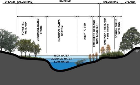
Source: National Wetlands Inventory
According to this database, Cherry County has the three wetland systems of estuarine, riverine, and lacustrine. The majority of the wetlands in the county occur, mostly along the Niobrara River and as meadow areas (mostly around the Wood Lake area). However, there are smaller wetland pockets scatteredthroughout Cherry County.
Figures 10.1, 10.2, and 10.3 depict common examples of the riverine, lacustrine, and palustrine wetlands, respectively. Figure 10.4 shows the occurrence of wetlands in Cherry County. These figures were produced by the United States Fish and Wildlife Service, and are taken from their 1979 publication entitled “Classification of Wetlands and Deepwater Habitats of the United States”, some enhancement was completed in order to place accents on keyareas.
Figure 10.1 shows the riverine system includes all wetlands occurring in channels, with two exceptions: (1) wetlands dominated by trees, shrubs, persistent emergent, emergent mosses, or lichens, and (2) habitats with water containing ocean derived salts in excess of 0.5%. A channel is an open conduit either naturally or artificially created which periodically or continuously contains moving water, or which forms a connecting link between two bodies of standing water. Therefore, water is usually, but not always, flowing in the riverine system.
Springs discharging into a channel are also part of the riverine system. Uplands and palustrine wetlands may occur in the channel, but are not included in the riverine system. Palustrine MossLichen Wetlands, Emergent Wetlands, Scrub-Shrub Wetlands, and Forested Wetlands may occur
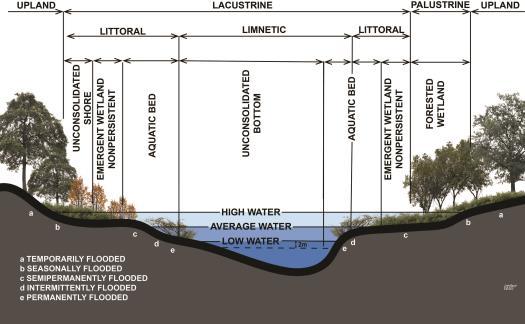
Source: National Wetlands Inventory
adjacent to the riverine system, often in a floodplain.
The Lacustrine System includes wetlands with all of the following characteristics: (1) situated in a topographic depression or a dammed river channel; (2) lacking trees, shrubs, persistent emergents, emergent moss or lichens with greater than 30% area coverage; and (3) total area exceeds 20 acres. Similar wetland areas totaling less than 20 acres are also included in the Lacustrine System if an active wave-formed or bedrock shoreline feature makes up all or part of the boundary, or if the water depth in the deepest part of the basin exceeds 6.6 feet (2 meters) at low water.
The Lacustrine System includes permanently flooded lakes and reservoirs (e.g. Lake Superior), intermittent lakes (e.g. playa lakes), and tidal lakes with ocean-derived salinities below 0.5% (e.g. Grand Lake, Louisiana). Typically, there are extensive areas of deep water and there is considerable wave action. Islands of Palustrine wetlands may lie within the boundaries of the Lacustrine System.
The Palustrine System includes all nontidal wetlands dominated by trees, shrubs, persistent emergent, emergent mosses or lichens, and all such wetlands that occur in tidal areas where salinity due to ocean-derived salts is below 0.5%. It also includes wetlands lacking such vegetation, but with all of the following four characteristics: (1) area less than 20 acres; (2) lacking active wave-formed or bedrock shoreline features; (3) water depth in the deepest part of basin less than 6.6 feet (2 meters) at low water; and (4) salinity due to ocean-derived
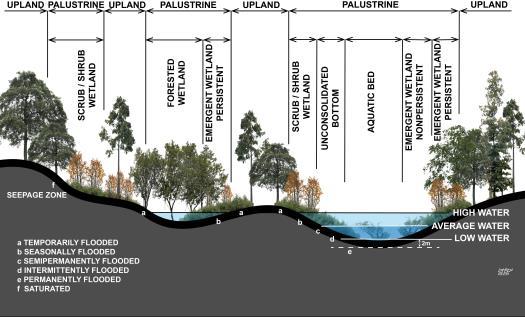
Source: National Wetlands Inventory
salts lessthan 0.5%.
The Palustrine System was developed to group the vegetated wetlands traditionally called by such names as marsh, swamp, bog, fen, and prairie, which are found throughout the United States. It also includes the small, shallow, permanent, or intermittent water bodies often called ponds. These wetlands may be situated shoreward of lakes, river channels, or estuaries; on river floodplains; in isolated catchments; or on slopes. They may also occur as islands in lakes or rivers.
Best Management Practices are a practice or combination of practices determined to be the most effective and practicable means of preventing or reducing the amount of pollution generated bynon-point sources.
There is a vast diversityof riparian,groundwater and wetland areas in Cherry County, in terms of waterway or impoundment types, climatic factors, up and down stream watershed impacts, condition, trend, potential for improvement, and opportunityfor management changes.
The National Wild and Scenic Rivers Act, 16 U.S.C.§1271-1287, provides the guidance for identification and designation of individual river segments for study and for recommendation for
inclusion in the system in order to provide balance with Dams (development) and to provide unique representationwithinthenational system.
Section 1271 called for protection of "certain selected rivers of the Nation, which, with their immediate environments, possess outstandingly remarkable scenic, recreational, geologic, fish and wildlife, historic, cultural or other similar values." Among those "certain selected rivers" there are now in Cherry County some rivers, which have either been included in the system or proposed for inclusion as "outstandinglyremarkable" rivers.
The Cherry County Board is satisfied there is no further need for including any other segments of rivers or tributaries within Cherry County in the national system and there are no others which meet the standards set bySection 1271.
Based upon inaction by Congress to further act on the additional areas, the remaining areas, if not already done, should be released from the designated program. Based upon 16U.S.C.§1283… the section shall not be "construed to abrogate any existing rights, privileges, or contracts affecting Federal lands held by any private party without the consent of said party.
Cherry County has over 100 different soils scattered throughout the county. The Cherry County Soil Survey identifies key aspects of each soil. Soils that have profiles almost alike make up a soil series. A summary of soil qualities for the four predominate soil series is included in Appendix A.
The largest occurring soil series are soils of the Valentine association. Comprised mostly of fine sand with limited amounts of loam in lower elevations, these soils occupy about 3,021,000 acres or 79% of all land in the County. Occurring on the level to hilly lands with slopes from 0% to 24% on uplands in the County, Valentine soils are susceptible to wind and water erosion, and absorb water quickly due to high permeability. Most of the soils in this association are used as native rangeland and with some irrigated cropland in lower and flatter areas.
The second largest occurring soil series in the County is the Ipage association. These soils are also comprised mostly of fine sand. Occupying roughly 153,700 acres or 4% of all land in the County, they
occur generally in the interdune areas throughout the County. Like the Valentine soils, the Ipage soils are susceptible to wind and water erosion, particularly in sloping areas and absorb water quickly due to high permeability. Most of the soils in this association are used as native rangeland and with some irrigated cropland.
The third largest occurring soil series in the County is the Els association. Comprised mostly of fine sand, these soils total around 91,700 acres or 2.5% of all land in the County. Els soils also occur generally in the interdunal areas. Like the Valentine and Ipage soils, the Els soils are susceptible to wind and water erosion, particularly in sloping areas and absorb water quickly due to high permeability. Most of the soils in this association are used as native rangeland and with some irrigatedcropland.
The fourth largest occurring series in the County is the Mckelvie association. Unlike the other soils, these colluvial soils are comprised mostly of fine sand and loam. These soils occupy about 81,500 acres or 2.1% of all land in the County and occur along the stream and river valleys. These areas can range from relatively flat on valley bottoms to slopes of up to 60% on the valley sides. Even with higher levels of loamy soils, the Mckelvie soils are susceptible to wind and water erosion, particularly in sloping areas and absorb water quickly due to high permeability. Most of the soils in this association are used as native rangeland and with steeper sloped areas being wooded.
The previously discussed uses are typical to counties similar to Cherry County. Earlier in this Chapter, the issue of wetlands was covered in some detail and is very closely associated with surface and groundwater. The following topics are greatly influenced by the type of soil and its location in an area. The following paragraphs will focus on Prime Farmland and Percent of Slope.
Prime farmland is directly tied to the specific soils and their composition. A map in the Appendices shows Prime Farmland, Prime Farmland if Drained, Farmland of Statewide Importance, and Not Prime Farmland.
According to the USDA, Prime farmland “...is land that has the best combination of physical and
chemical characteristics for producing food, feed, forage, fiber, and oilseed crops. It must also be available for these uses. It has the soil quality, growing season, and moisture supply needed to produce economically sustained high yields of crops when treated and managed according to acceptable farming methods, including water management. In general, prime farmlands have an adequate and dependable water supply from precipitation or irrigation, a favorable temperature and growing season, acceptable acidity or alkalinity, acceptable salt and sodium content, and few or no rocks. They are permeable to water and air. Prime farmlands are not excessively erodible or saturated with water for a long period of time, and they either do not flood frequently or areprotectedfromflooding.”
Prime farmland is one of several kinds of important farmland defined by the U.S. Department of Agriculture. It is of major importance in meeting the nation's short- and long-range needs for food and fiber. The acreage of high-quality farmland is limited, and the U.S. Department of Agriculture recognizes that government at local, state, and federal levels, as well as individuals, must encourage and facilitate the wise use of our nation's prime farmland.
Prime farmland soils, as defined by the U.S. Department of Agriculture, are soils that are best suited to producing food, feed, forage, fiber, and oilseed crops. Such soils have properties that are favorable for the economic production of sustained high yields of crops. The soils need only to be treated and managed using acceptable farming methods. The moisture supply, of course, must be adequate, and the growing season has to be sufficiently long. Prime farmland soils produce the highest yields with minimal inputs of energy and economic resources, and farming these soils results in the least damage tothe environment.
Prime farmland soils may presently be in use as cropland, pasture, or woodland, or they may be in other uses. They either are used for producing food or fiber or are available for these uses. Urban or built-up land and water areas cannot be considered prime farmland.
Prime farmland soils usually get an adequate and dependable supply of moisture from precipitation or irrigation. The temperature and growing season are favorable. The acidity or alkalinity level of the soils is acceptable. The soils have few or no rocks
and are permeable to water and air. They are not excessively erodible or saturated with water for long periods and are not subject to frequent flooding during the growing season. The slope ranges mainlyfrom 0 to6 percent.
Soils that have a high water table, are subject to flooding, or are droughty may qualify as prime farmland soils if the limitations or hazards are overcome by drainage, flood control, or irrigation. Onsite evaluation is necessary to determine the effectiveness of corrective measures. More information on the criteria for prime farmland can be obtained at the local office of the Natural Resources Conservation Service.
Cherry County contains approximately 3,845,903 acres of land within the county borders. The Prime Farmland found in the county is in two forms: Farmland of Statewide Importance and Prime Farmland,if drained.
The map located in the Appendices shows the location of Prime Farmland within Cherry County and the amount of these two classifications are very limited. Farmland of Statewide Importance makes up a total of 20,725.4 acres or 0.54% of the total county; while Prime, if drained had 47,307.7 acres or 1.23% of the entire county. All together, Prime Farmland makes up only 1.77% of Cherry County.
Soils determined to be prime farmland need to be protected throughout the rural areas of Nebraska. These soils are typically the best crop producing lands.
The slope of an area is critical to the ability of the location to be used for agricultural purposes to constructing homes and septic systems. Typically the steeper the slope the more difficult these issues become. However, lands with little to no slope can also create problems regarding the inability of water todrain awayfrom a site.
Cherry County has steep slopes in limited locations throughout the entire county; however, some of the steepest are in the northeast along the Niobrara River.
As seen in Table 10.1 slope is a factor in several soils/locations in the county. In a number of situations, any soil conditions based upon slope could likely be engineered to become more compatible. However, it is important to involve an
Source: USDA/NRCS
engineer, geologist, or soil scientist in the issue in order to make the correct modifications throughout the county.
Permeability is defined in the Cherry County Soil Survey as...”The quality of the soil that enables water to move downward through the profile. Permeability is measured as the number of inches per hour that water moves downward through saturatedsoils.”Permeabilityisratedas:
Veryslow lessthan 0.06 inches
Slow 0.06 to0.20 inches
Moderatelyslow 0.2 to0.6 inches
Moderatelyrapid 2.0 to6.0 inches
Rapid 6.0 to20 inches
Veryrapid more than 20 inches
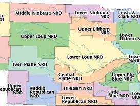
Hennings
Sandrose Hennings 0-16 16-30 30-48 48-60 0-17 17-29 29-35 35-55 55-60 6-20
Sandrose
0-5 5-12 12-79 0-18 18-57 57-79 6-20 6-20 6-20 6-20 .6-6 .6-6
0-7 7-14 14-79 0-19 19-37 37-58 58-79 6-20 6-20 6-20 6-20 6-20 .6-6 .6-6
Surface water applies to any water running across a surface and eventually runs into a minor drainage area, eventually ending up in a major waterway such as the Niobrara River. However, a certain portion of surface water can and is absorbed by the soil in order to support plant life including corn, soybeans,and grass lawns.
Cherry County lies in two distinct watersheds, these are defined and drainage areas controlled by the respective Natural Resource District. The two districts covering Cherry County are the Middle Niobrara Natural Resource District and the Upper Loup Natural Resource District. The Middle Niobrara is based in Valentine, Nebraska, while the Upper Loup is in Thedford, Nebraska.
Source:Websoil Survey
Table 10.2 following indicates the various permeability rates for each soil and at what depth the rating was taken. The Table indicates those considered to be moderately rapid or higher in red. There are a number of soils in Cherry County with a permeabilityof twentyinches per hour or more.
There are a number of specific uses not compatible for soils rated as Moderately rapid or higher. Soils rated at these levels will move contaminated materials much faster through the profile and into the regional water tables and aquifers. These uses will typically include anything dealing with animal or human sanitarywastesystems.
Permeability, as with other soil factors, can be overcome with the proper engineering and construction techniques. Caution is a must when dealing with these conditions since the potential for contaminating an aquifer that feeds an entire area withwater is a risk.
Water, along with the soils are the two most restricting environmental conditions faced by Cherry County. Damaging either one of these two elements will impact the residents of the county for years to come. As with the soil descriptions and conditions, it is important to discuss the water factors impacting Cherry County during the present and coming planning period. Water in this section will apply to two topics, surface water and ground water.
Groundwater refers to water found beneath the surface and includes smaller pockets of water as well as aquifers. This water source is where the residents of Cherry County both city and rural, get their potable water for everyday living as well as the irrigation water for crops. The ability to find water meetingthese specific needs is critical.
Irrigated and Intensive agriculture, including row crops, are critical to the economic base of the County and are important to the economic stability of the County. The Nebraska legislature has recognized that importance in Nebraska statute, §23-114.04.
Irrigation wells in Cherry County are very limited for two reasons: the typical depth to water and the type of soils are not conducive to crops like corn, soybeans, etc. The main location for irrigation wells in Cherry County are in the northern areas near the Niobrara River.
Typically domestic and most livestock water supplies are obtained through the use of small diameter wells. Most of these wells are drilled only a few feet below the top of the water table, are low production wells, and equipped with windmills, electric powered jet, or submersible pumps. The water yield of this type of well is usually no more than five gallons of waterper minute.
The public water supply is one of the most critical uses of groundwater resources. These supplies are
used by the municipalities supplying water to its residents. In Cherry County, all of the incorporated communities have a publicly owned water supply system.
The State of Nebraska places a great deal of value on these systems across the state. The value is so high that a Wellhead Protection Program is available to municipalities through Nebraska Department of Environment and Energy. This program allows the municipalities, after a series of prescribed steps are completed, to designate special areas around their wells and well fields in order to protect the quality and quantity of the water within the underlying aquifers. Development of a community wellhead protection plan can help communities receive financial assistance to protect and secure the source of drinking water for the community.
GENERAL RIGHTS
Nebraska water resources play a major role in the state's heritage and economy. Beginning with the state constitution, Nebraska surface waters have been governed by the Appropriative First-in-Time, First-in-Right Rule which allows diversion of water from the surface waters of the state based upon the date the water right was obtained. (Source: water.unl.edu/ article/ agricultural - irrigation/ regulations-policies )
CORRELATIVE WATER RIGHTS FOR GROUNDWATER
Correlative Rights govern the use of Nebraska ground waters. Correlative Rights allow landowners to drill wells and extract groundwater from an underlying aquifer for beneficial purposes subject to management by the public. In 1957 the Unicameral passed legislation requiring the registration of all irrigation wells.
To execute this right, landowners now must first obtain a permit to drill a well from their local Natural Resources District. If approved, the well permit allows the land owner to drill a well and extract as much groundwater as needed as long as the use is deemed beneficial. When the well development is completed the well permit is registered with the NDNR which places the information in a statewide data base. (Source: water.unl.edu/ article/ agricultural- irrigation/ regulations-policies)
All rules and regulations governing the use of groundwater and surface water are found listed in,
"State of Nebraska, Department of Natural Resources, Ground Water, Chapter 42, Article 2 and Article 6". These chapters and articles establish the nature of water rights as rights of reality, define the process by which such rights are acquired, protect such vested rights and establish the Nebraska Department of Water Resources as the control agencyregarding surface and ground water.
A Wellhead Protection Area is a delineated area indicating where a water source is located, as well as the area of travel for a specific well or well field. A wellhead protection area is important from the aspect that correctly implemented, the area will aid in protecting the water supply of a domestic well providing potable water toa community.
In Nebraska, the goal of the Nebraska Department of Environment and Energy Wellhead Protection Program “...is to protect the land and groundwater surrounding public drinking water supply wells from Contamination”. Within the NDEE’s program there are five steps to developing a wellhead protection area,which are:
1. Delineation
2. Contamination Source Inventory
3. Contaminant Source Management
4. Emergency, Contingency, and Long-term Planning
5. Public Education
The mapping process includes the use of computer modeling and other data. From this the NDEE can generate a map indicating the wellhead Protection Area. However, delineating an area is not sufficient for protecting the groundwater around a public supply well, the governmental entity must adopt an ordinance in order to enforce the area and the regulations used to protect this water supply. Another way to officially regulate a wellhead protection area is for the community to create an interlocal agreement with the County to regulate these areas as part of the county comprehensive plan and zoning regulations.
Hydric soils are formed under conditions of saturation, flooding, or ponding. The process has to occur long enough during the growing season to develop anaerobic conditions in the upper part. Hydric soils along with hydrophytic vegetation and wetland hydrology are used to define wetlands. (USDA/NRCS, Fall 1996)
A map in the Appendices shows where the hydric soils are located in Cherry County. The soils are classified as the following:
• All Hydric;or
• Not Hydric
The majority of the soils in Cherry County are considered Not Hydric. Overall, a small amount of soils are considered as 100%Hydric or All Hydric.
Flooding is the temporary covering of the soil surface by flowing water from any source, such as streams and rivers overflowing their banks, runoff from adjacent or surrounding slopes, or a combination of different sources. During a flooding event there are a number of components that make up the flooded area. These areas include:
• Floodway which is the channel of a watercourse and those portions of the adjoining floodplains which are required to carry and discharge the 100- year flood with no significant increase in the base flood elevation.
• Floodplain which is the low land near a watercourse which has been or may be covered by water from flood of 100-year frequency, as established by engineering practices of the U.S. Army Corps of Engineers. It shall also mean that a flood of this magnitude may have a 1 percent chance of occurring in anygiven year.
• Floodway Fringe which is that portion of a floodplain that is inundated by floodwaters but is not within a defined floodway. Floodway fringes serve as temporary storage for floodwaters.
The floodplain also includes the floodway and the flood fringe, which are areas covered by the flood, but which do not experience a strong current.
The floodplain area of greatest significance in terms of state and federal regulation is the 100 year floodplain. This area is defined by the ground elevation in relation to the water elevation experienced during a 100 year flood event. The 100 year floodplain is calculated to be the elevation level of flood water expected to be equaled or exceeded every 100 years on average. In other and more accurate words, the 100 year flood is a 1% flood, meaning it defines a flood that has a 1% chance of being equaled or exceeded in any single year.
Preserving the floodplain and floodway are critical to limiting the level of property damage that can
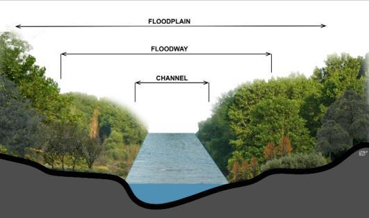
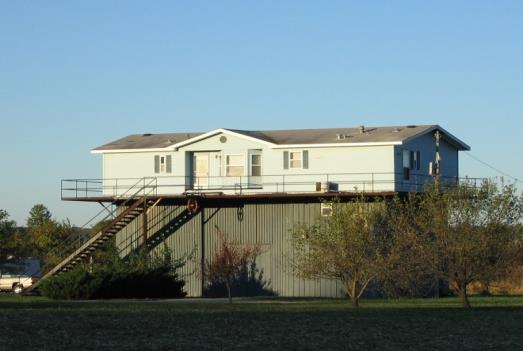

occur as well as the level of damage to life of the occupants of the area. Land when not flooded seems to be harmless, but it is those rare times that threaten life and property that need to be controlled.
All this said, Cherry County as a whole is not mapped for floodplains and floodway. However, Valentine and Codyare in the flood program.
In recent years there have been numerous flooding occurrences in Nebraska and the Midwest. These events have included the Platte River, the Niobrara River (downstream from Cherry County, the Missouri River, and the Mississippi River, as well as their tributaries. Each of these events have caused significant damage tolife and property.
In order to protect an individual’s property there are specific rules and guidelines that need to be followed. Most guidelines are developed for 100 year flooding events. The times the guidelines have not worked are typically referred to a 500 year event for lack of a better term. However, in some cases, due to mother nature and increases in development runoff, the area needed to handle the floodway and floodplain (100 year event) have increased due to the amount and speed of the water reaching the streams and rivers.
Natural Resource Goal 1
To maintain or improve the landscape, soil, and vegetation as well as watershed resources in a manner that perpetuates and sustains a diversity of uses while fully supporting the custom, culture, economic stability and viability of Cherry County and our individual citizens.
WATER
Water Goal 1
Meet the requirements for water quality contained in the State of Nebraska water quality plan to the extent they can be met while complying with Nebraska constitutional and statutory law as to vested water rights and control of in-stream flow, and to maintain or improve riparian areas and aquatic habitat that represents a range of variabilityfor functioning condition.
Water Policies and Strategies
W-1.1 Encourage the use of Best Management Practices (BMP's) for those waters which have been specifically identified and documented as not meeting beneficial use. BMPs include but are not limited to: Prescribed grazing systems, off site water
development, red cedar control, livestock salting plans, establishment of riparian pastures,herding.
W-1.2 All riparian, ground water and wetland management decisions are best resolved on a site-specific basis.
Water Goal 2
Protect both the surface water and groundwater that runs through and is under the county.
Water Policies and Strategies
W-2.1 Encourage the private conservation of sensitive areas such as wetlands, wooded areas, waterways (streams, ponds, lakes, rivers,etc.).
W-2.2 Protect all water supplies and aquifers from development activities that may affect the quality of water; development must demonstrate a positive or, at least, a neutral impact on groundwater.
W-2.3 Land use development within the floodplains of the county should be avoided.
W-2.4 Cherry County encourages soil and water conservation efforts to aid in erosion, sediment, and run-off control where possible.
W-2.5 Cherry County encourages protection of riparian vegetation from damage that may result from development.
W-2.6 Cherry County will urge better development of water supply consistent with the statutory and constitutional standards and will work to protect established water rights in accordance with such standards.
W-2.7 Cherry County opposes the expansion of the federal regulation of wetlands beyond the traditional understanding of navigable waters, which means waters that provide a channel for commerce and transportation of people and goods.
W-2.8 Any rivers within Cherry County considered “outstandingly remarkable areas” under The National Wild and Scenic Rivers Act, 16 U.S.C. §§1271-1287, that have not already been designated, should be released from consideration.


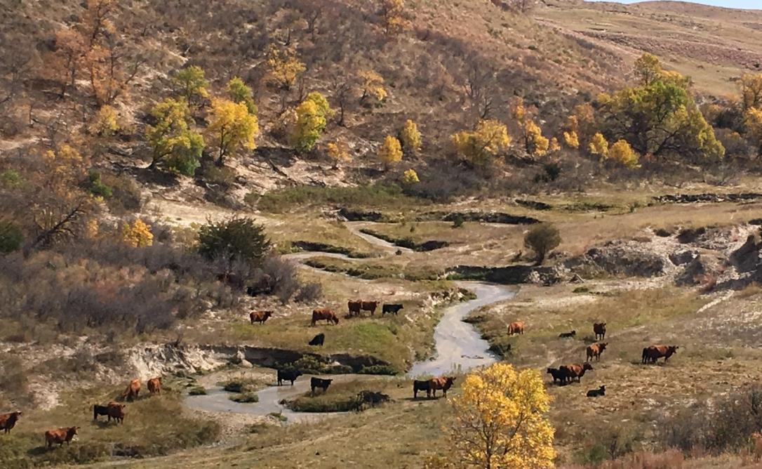
The elements of the Cherry County Land Use Chapter include:
Land Use in Cherry County
• Zoning and Property Rights
• Existing Land Uses
• Management and Ownership of the Land
• Management of Protected Species, Wildlife, and Wildlife Habitat
• Coordination with Stateand Federal Agencies
Land Use Policies
• General Land Use Policies
• Cattle Country Agriculture Area
• Niobrara River Corridor
• Threatened, Endangered and At-Risk Species and Plan Conservation Plans
• The National 30x30 Land Preservation Initiative and Other Similar Goals
• Conservation Easements
• Federal and State Coordination
• Wellhead Protection Areas
• Growth and Development
• Federal and State Natural Resource Management Plans
When implementing zoning regulations, a primary concern of the County is to implement the policies in such a way as they do not infringe on the private property rights of landowners. When used correctly, land use policy and zoning are protective as opposed to restrictive, and should be implemented in a limited fashion for the purpose of protecting the historical culture and future opportunities of Cherry Countycitizens.
Protective land use policy and zoning should work to be a protection to each individual landowner so their neighbor’s activities do not harm the property “value” and investment already committed to a piece of land.It is often forgotten that our individual rights cease once we infringe on another's rights. This document, specifically this Chapter, strives to protect every Cherry County citizen’s rights and investment. A key means to protecting these rights is by having a complete understanding of the existing uses in the county as well as the historical culture of the area.
The framers of the United States Constitution relied on the philosophy of John Locke, who argued that individual natural rights including the rights to obtain and hold property, were not derived from the sovereign or the government but were in fact natural rights in the nature of “the common gift of
mankind.” Locke’s position was based upon a simple method of individual acquisition of property rights or property interests: “individuals are allowed to keep that which they first reduce to their own possession.”
Locke’s political philosophy set forth the view that the organization of a government does not require the surrender of all natural rights including property rights and interests to the sovereign. In accordance with that view if the government takes a property right or a propertyinterest then it must payfor it.
The framers of the United States Constitution accepted the Locke theories and, as a result, the Fifth Amendment to the United States Constitution prohibits the taking of private property for public use without just compensation.
The predominate land use in Cherry County is agriculture, which includes row crops, livestock, grazing, and haying. In addition, Cherry County has natural amenities such as the Niobrara River, a major recreational corridor in the State.
As the largest beef cow producing county in the nation, Cherry County must continue to maintain its agricultural crop and livestock production to ensure a productive and balanced natural environment. In addition, the area should promote new forms of agricultural production which are compatible with existing ranch and farm uses.
The concept of this agricultural area is to encourage soil and water conservation, preserve water quality, and prevent contamination of the natural environment within the County, through the productive use of the land. Ranch and farm operations must be protected and have priority when conflicts arise withnon-agricultural uses.
Overall, protecting the long-standing way of life in the rural areas of Cherry County is critical to the future. Uses incompatible with the current agricultural methods should be limited and any incompatible components should be mitigated prior tobeing allowed inthis area.
The term “Existing Land Use” refers to the current uses in place within a building or on a specific parcel of land. The number and type of uses can
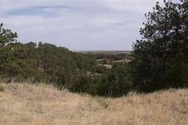
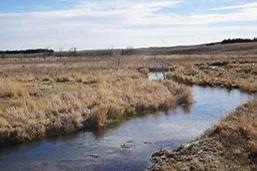
constantly change within a county and produce a number of impacts either benefiting or detracting from the county. Because of this, the short and long -term success and sustainability of the county is directly contingent upon available resources utilized in the best manner.
Overall, development patterns in and around Cherry County have been influenced by topography, water, soils and manmade features such as highways and some hard-surfaced county roads. These items will likely continue to influence development patterns throughout the course of the planning period.
The utilization of land is best described in specific categories providing broad descriptions where numerous businesses, institutions, and structures can be grouped. For the purposes of the Comprehensive Plan, the following land use classifications are used:
• Farmsteads/residential uses
• Commercial uses
• Quasi-Public/Public (includes churches and schools)
• Livestock facilities
• Agriculture
The above land use categories may be generally defined in the following manner:
Agriculture - Row crop, alfalfa, pastureland/grazing land and all grain crops are considered agriculture land uses. Cherry County is an agricultural based county and the existing land use map verifies these uses.
Nebraska N.R.S. §77-1359 defines agriculture and horticulture lands as follows:
1. Agricultural land and horticultural land means a parcel of land, excluding land associated with a building or enclosed structure located on the parcel, which is primarily used for agricultural or horticultural purposes, including wasteland lying in or adjacent to and in common ownership or management with other agricultural land and horticultural land;
2. (a) Agricultural or horticultural purposes means used for the commercial production of any plant or animal product in a raw or unprocessed state that is derived from the science and art of agriculture, aquaculture, or horticulture;
(b) Agricultural or horticultural purposes includes the following usesof land:
(i) Land retained or protected for future agricultural or horticultural purposes under a conservation easement as provided in the Conservation and Preservation Easements Act except when the parcel or a portion thereof is being used for purposes other than agricultural or horticultural purposes;and (ii) Land enrolled in a federal or state program in which payments are received for removing such land from agricultural or horticultural production; and
(c) Whether a parcel of land is primarily used for agricultural or horticultural purposes shall be determined without regard to whether some or all of the parcel is platted and subdivided into separate lots or developed with improvements consisting of streets, sidewalks, curbs, gutters, sewer lines, water lines,or utilitylines;
3. Farm home site means land contiguous to a farm site which includes an inhabitable residence and improvements used for residential purposes and which is located outside of urban areas or outside a platted and zoned subdivision;and
4. Farm site means the portion of land contiguous to land actively devoted to agriculture which includes improvements that are agricultural or horticultural in nature, including any uninhabitable or unimproved farm home site.
Livestock facilities– These are specific confinement buildings including chicken and swine houses, dairies,and open lots.
Residential– This category includes residential dwellings either as a farmstead, acreage or residential developments located within the county. Residential units of this type are distributed throughout the County.
Commercial- Uses in this category consist of convenient stores; feed, seed, automobile and machinery sales; petroleum sales, etc. Commercial uses tend to be located near urban areas or in proximitytomajor highways for accessibility.
Industrial/Railroad Right-of-Way - Land uses of this nature may include communication plants, light manufacturing, commercial storage, industrial parks, large salvage yards, etc. These uses tend to be located near municipalities and major
transportation routes for accessibilitypurposes.
Cherry County has approximately 3,828,500 acres. The federal government owns approximately 207,290 acres and the State owns another 169,665 acres. Combined the State and Federal government owns 10 percent of the land within the jurisdiction of Cherry County. In addition to this, 23.7 miles of the Niobrara River are designated a National Scenic River requiring additional restrictions on landowners within the designated area.
Several landowners own over 100,000 acres each. Other entities such as The Nature Conservancy, a non-profit land trust, also have significant holdings in Cherry County.
Each of these entities have competing land use purposes that often conflict with the priorities of Cherry County. Where the land is managed by an individual property owner with roots in Cherry County, sometimes dating back to the original homesteads, their emphasis is on wisely using the lands in such a manner as the land can be passed down to future generations who can build on the same conservation principles. However, when the land is purchased by for-profit/non-profit entities, who often buy the land at inflated prices, with the goal of changing the land use from agriculture to protection of species or resources, these can conflict with the County’s policies. Additionally, when the land owned by Federal or State government is managed as protected areas, conflicts can arise with the County’s policies and the landowners who are authorized to use these lands under Federal and State laws.
Historically, when the private lands have been acquired by entities with goals that conflict with agriculture uses, the local farmers and ranchers whose families have been on these lands for generations are harmed.
Fundamentally, Cherry County’s policies regarding the use of our federal lands are aligned with the
provisions made in the Federal Land Policy and Management Act of 1976 and the National Forest Management Act of 1976. These Acts require federal agencies to coordinate the land use inventory, planning, and management activities for such lands with the land use planning and management programs of local governments Land Use within which the lands are located. Equally important, Cherry County’s policies support the guiding principles of multiple use and sustained yield.
These core principles of this plan are defined as the following:
The management of the public lands and their various resource values so that they are utilized in the combination that will best meet the present and future needs of the American people; making the most judicious use of the land for some or all of these resources or related services over areas large enough to provide sufficient latitude for periodic adjustments in use to conform to changing needs and conditions; the use of some land for less than all of the resources; a combination of balanced and diverse resource uses that takes into account the long-term needs of future generations for renewable and non-renewable resources, including, but not limited to, recreation, range, timber, minerals, watershed, wildlife and fish, and natural scenic, scientific and historical values; and harmonious and coordinated management of the various resources without permanent impairment of the productivity of the land and the quality of the environment with consideration being given to the relative values of the resources and not necessarily to the combination of uses that will give the greatest economic return or the greatest unit output. (43 USC 1702(c)).
The achievement and maintenance in perpetuity of a high-level annual or regular periodic output of the various renewable resources of the public lands consistent with multiple use. (43 USC1702(h)).
The public lands shall be managed in a manner that will protect the quality of scientific, scenic, historical, ecological, environmental, air and atmospheric, water resource, and archeological values; that, where appropriate, will preserve and protect certain public lands in their natural condition; that will provide food and habitat for fish and wildlife and domestic animals; and that will
provide for outdoor recreation and human occupancy and use. (43 USC 1701(a)(8)) Public lands shall be managed in a manner which recognizes the Nation’s need for domestic sources of minerals, food, timber, and fiber from the public lands including implementation of the Mining and Minerals Policy Act of 1970 as it pertains to the public lands. (43 USC1701(a)(12)).
D. Coordination
The process of harmonizing Federal, state, and local plans to achieve consistent application of policies across multiple jurisdictions. Federal law requires the federal land management agencies work to make their policies consistent with local plans and policies to minimize conflicts and support economic growth.Coordination is a distinct process involving those governing jurisdictions that have planning responsibilities and often taxing authority and is a continuous process.
E. Cooperating Agency
During the development of an Environmental Impact Statement (EIS) under The National Environmental Policy Act (NEPA), and Council on Environmental Quality regulations (CEQ Regs), State, local and tribal governments can be invited to participate with federal and state agencies, in the preparation of the impact analysis as a “Cooperating Agency.” The development of the analysis can be for major federal actions such as the revision of a natural resource plan that will determine future management activities on the federal lands. Although “Cooperating Agency Status” was originally reserved for agencies, local governments have been allowed to participate in this process in recent years and contribute their respective areas of responsibility, authority and expertise to the analysis. It is vital to the County that it be allowed to participate in all NEPA processes to help insure a robust and complete analysis is prepared that includes the County’s needs, policies and data.
The collaborative process is a beneficial way to bring agencies, State and local governments, private stakeholders and special interest groups together to work towards developing common goals that can help shape the management of the public lands. Although the outcome of the collaborative process is not binding on federal, state or local governments, the objectives, goals and suggested strategies should be considered during the various planning processes.
Management decisions for the federal and state lands directly impact the use of, and the economic value of, private land. Any reduction of the present use of these lands not only adversely impacts the rancher using them, but also the economic base of Cherry County. Inversely, increased use of these lands will have a beneficial impact to the rancher and likewise the economic base of Cherry County.
Restrictions on and reductions of grazing on federal lands, for example, would require a rancher to greatly increase grazing on private ground, reduce the size of their herd, find alternative grazing land, or seek relief through a combination of these measures. If they must graze their herd solely on their own private ground, then they will lose their source of winter forage for their herd.
There is limited alternative land available within the County, as well as in neighboring areas. Transportation costs would be extremely high and even prohibitive if producers had to graze their cattle outside the area. Either reduction in herd size, higher feed costs, or severely increased transportation costs would result in a critically adverse outcome for the rancher and the county as a whole. Economists hold that for every ranching dollar lost,there is a two-fold loss tobusinessincome in the surrounding area of the county.
The portion of the county’s economy dependent upon the canoeing industry (on the Niobrara River) is conversely dependent on federal land management decisions regarding activities on the river. Severe restrictions by federal management agencies would curtail canoeing activities, resulting in the reduction of a critical component of the county’seconomic diversity.
Reductions in recreation use by federal and state management agencies will also result in adverse economic impacts on businesses in the county. The recreational uses in Cherry County are visited by users across the United States; many of these uses are located on state and federal lands. These users spend their money and time in the communities of Cherry County; therefore the economic stability of Cherry Countyrests upon continued multiple uses of federal and state lands.
According to the Valentine Wildlife Refuge, Cherry County has considerable wildlife including 292 bird species, 43 mammal species, 16 reptile species, and six amphibian species. Due to the uniqueness and vastness of the Sandhills ecosystem there are alsowildlife considered tobe endangered. Some of these species make their home in Nebraska while some pass through during keypoints of the year.
According to the U.S. Fish and Wildlife Service, there are currently nine federally protected and candidate species and plants found in the Cherry County.These are:
• Regal fritillary(Speyeria idalia)
• Monarch butterfly(Danaus plexippus)
• Western prairie fringed Orchid (Platanthera praeclara)
• Northern Long-Eared Bat(Myotis septentrionalis)
• American burying beetle (Nicrophorus americanus)
• Topeka shiner (Notropis topeka (=tristis))
• Whooping crane (Grus americana)
• Blowout penstemon (Penstemon haydenii)
• Piping Plover (Charadrius melodus)
The Nebraska Game and Parks currently lists additional species in Cherry County it considers atrisk through the Natural Legacy Project and the Nebraska State Wildlife Action Plan.These include:
• Northern RedbellyDace
• Blacknose Shiner
• Small WhiteLady’sSlipper
• Finescale Dace
• Swift Fox
These lists are ever changing.
The County will pay particular attention to any species designated in any category or classification for protection or consideration of protection under the Endangered Species Act and will expect the federal agencies to consider the conservation measures and policies of the county prior to advancing any proposal to federally protect a species or plant that mayimpact the County.
The Endangered Species Act requires that a determination to protect a species can only occur “after taking into account those efforts, if any, being made by any State or foreign nation, or any
political subdivision of a State or foreign nation, to protect such species, whether by predator control, protection of habitat and food supply, or other conservation practices, within any area under its jurisdiction, or on the high seas.” (16 U.S.C.A., Section 1533 (B)(1)(A)).
The Act defines “conservation” efforts as the following: “Such methods and procedures include, but are not limited to, all activities associated with scientific resources management such as research, census, law enforcement, habitat acquisition and maintenance, propagation, live trapping, and transplantation …”(U.S.C.A.,Section 1532(3)).
Regardless of whether there is a specific species plan developed by the county, this Comprehensive Plan and its policies were prepared with the land use goal of ensuring that all non-invasive species and plants that benefit the Sandhills ecosystem are provided adequate habitat, and therefore, this plan should be considered the conservation plan for all species and plants withinthe County.
All decisions for wildlife management should be for the purpose of maintaining the balanced wildlife populations, which our citizens have grown accustomed to enjoying in consumptive and nonconsumptive manner.
Better coordination of deer hunting seasons with private property use and livestock management should be a priority of the state agencies. State management plans for hunting seasons should be coordinated with the county to help facilitate a good relationship with private landowners. These coordinated efforts will help to ensure a healthy balanced population of wildlife, workable hunting seasons with private property uses and livestock management and incorporate depredation hunts toprotectthe value of the landowners investments.
Federal law requires the federal lands be managed to maintain the multiple uses and sustained yield of the resources in coordination with States and local governments. Maintenance of such multiple uses necessarily includes continued maintenance of the historic and traditional economic uses which have occurred on federally and state managed lands in the county. It is therefore essential that federal and state agencies keep apprised of and consider the
policies of Cherry County as set forth in this plan, and that these agencies inform the county of all pending or proposed actions impacting the local communities and industries, as well as, coordinate these actions with the Board as required bylaw.
The Cherry County Comprehensive Plan is the one unifying plan that takes into consideration all the different land uses, types of land ownership, management objectives of Federal and State agencies, as well as the needs and requirements of cities and special districts within the County’s jurisdiction. The purpose of the Comprehensive Plan is to ensure the activities of all these entities are harmonized and do not conflict with each other or the County’s policies, to ensure the health, safety andwelfareofCherry County’scitizens.
Because of this responsibility, delegated by the State of Nebraska to Cherry County, all entities must consider and coordinate their management plans with the Cherry County Comprehensive Plan as required by State and Federal Law.
GENERAL LAND USE POLICIES
1. Private ownership of land is essential to the freedom of individuals, families and communities and to the economic interests of the citizens of the County.
2. Existing agricultural uses, methods of agricultural production, property values and the lifestyle and quality of life of the citizens of the County should be protected and preserved.
3. Changes in non-agricultural uses should occur in a manner and in locations which will be compatible with such existing uses, which will not damage the environment, which will not negatively impact the infrastructure of the County and which will not negatively impact property values or the quality of life in the rural areas of the County.
4. Land use regulations should be minimized to preserve the freedoms and property rights enjoyed bythe citizens of the County.
5. The regulations should effectively address the needs to basic protection of the existing land uses, property values, the local environment and quality of life from development of future land uses which would be inconsistent with these needs.
GENERAL PURPOSE
This land use district is the means to maintain agricultural crop and livestock production which is in balance with the natural environment and promote other and new forms of agricultural production which is compatible with existing ranch and farm uses and the environment.
These areas are also meant to encourage soil and water conservation, preserve water quality, prevent contamination of the natural environment within the County and to preserve and protect ranch and farm operations from conflict with non-agricultural uses.
COMPATIBLE USES
1. Grazing land
2. Crop production
3. Familyresidential groupings
4. Confined livestock operations for all types of animals where conditions permit
5. Private grain storage
6. Commercial grain storage
7. Commercial uses related to agriculture such as: fertilizer processing and storage, grain elevators,etc.
8. Smaller commercial uses supporting the general area
9. Manure/fertilizer applications
10. Single acreage developments
11. Public and private recreational,wildlife and historical areas
12. Agri-Tourism activities such as: hunting preserves, fishing, vineyards etc.
13. Religious usesand structures
14. Educational usesand structures
15. Commercial mining
INCOMPATIBLE USES
1. Residential/Acreage developments not associated with a farming operation
2. Large commercial developments
POTENTIAL ISSUES TO CONSIDER
1. Sensitive Soils
2. Groundwater availability
3. Slopes
4. Topography
5. Natural amenities such as trees, ponds,and streams
6. Flooding hazards.
7. Groundwater contamination
8. Minimum lot sizes and residential densities
9. Wetlands
10. Existing and/or proposed sanitarysystems
11. Wellhead protection areas
12. Proximity to conflicting uses such as new acreages near livestock confinements
13. Transportation systems (countyroads,highways)
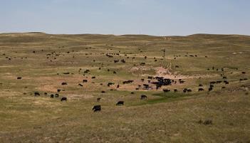
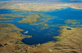
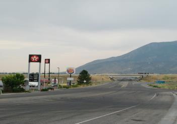
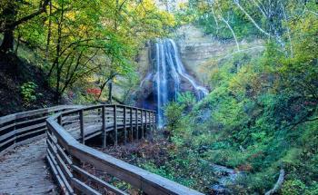
Source: visitvalentine.org
1. Minimum residential lot sizes should be kept at the lowest possible size accommodating both privatewater and sanitarysewer.
2. Cluster developments should be considered and used whenever soils,topography, natural amenities warrant.
3. Separation distances should be applied to the livestock facility and rural acreages.
4. Small livestock feeding operations should be a permitted use; while larger livestock feeding operations should be regulated through the conditional use process in order to help minimize environmental impacts on the health, safety and general welfare of the public.
5. Private property rights of everyone should be considered in all land use decisions.
Protect and preserve the livestock and agricultural lifestyles that CherryCountyhas become known for throughout its history.
CCLU-1.1 Use the definition of agriculture as laid out within this document.
CCLU-1.2 Every effort should be made to protect the overall culture of Cherry County for those living and working in agriculture.
CCLU-1.3 Where any non-agricultural development, other than development of a residential dwelling on a tract of land larger than 160 acres, should be required to execute and record a Cattle Country Easement.
CCLU-1.4 Make every effort to ensure changes in the use of land and water resources have no adverse impacts on the present and future viability of agricultural operations on lands that neighbor anysuch land use changes.
New confined feeding operations should meet specific requirements since this type of livestock production is not part of the overall culture of Cherry County.
Policies
CCLU-2.1 New confined livestock operations should be located in areas where their impact on neighboring land uses and the environmentwill be minimal.
CCLU-2.2 Cherry County should allow agricultural production throughout the county; except where there may be potential conflicts with other policies of this plan.
CCLU-2.3 Confined livestock operations should be encouraged to utilize odor reducing technologies such as methane digestion and composting.
CCLU-2.4 Regulations should be established and implemented creating setback and buffer requirements to minimize the impacts of solid, liquid, and gas emissions from confined livestock facilities.
CCLU-2.5 Protect the quality of groundwater in agricultural areas of CherryCounty.
Cherry County should continue to be proactive in protecting property rights while protecting the sensitive environment of the county.
Policies
CCLU-3.1 Work with livestock producers on a continual basis in evaluating protections and regulations.
CCLU-3.2 Continue conversations with state and federal officials regarding limited governmental control of lands in Cherry County.
Individuals moving to the Cattle Country area of Cherry County that are not associated with farming and ranching should be required to provide certain guarantees to existing property owners engaged in farming and ranching.
Policies
CCLU-4.1 Non-agricultural developments abutting grazing land should be fenced as defined in Neb. Rev. Stat.§34-115.
1. Fencing, or ensuring existing fences are sound should be the responsibility of the owner of the nonagricultural use.and
2. Such fences should be maintained by such owner unless there is a written agreement between such owner and the owner(s) of adjoining grazing land.
3. The only exception to this is if the non-agricultural landowners (s) having specific grazing agreements in place with the farmers and ranchers.
CCLU-4.2 Where any non-agricultural development, other than development of a single residential dwelling, can be anticipated to generate increased traffic on a county road passing through open range,the owner of such nonagricultural development may be required to fence such road to protect motorists and livestock if the anticipated traffic volumes are more than 50% greater than existing traffic volumes.
CCLU-4.3 Non-agricultural developments which abut grazing land should be required to install cattle gates or cattle guards with adjoining gate on all vehicular access points unless there is a written agreement between such owner and the owner(s) of adjoining grazing land.
CCLU-4.4 All new residents not associated or associated with a farming or ranching operation should be required to sign and acknowledge a statement outlining the potential conditions impacting those in the Cattle Country Land Use area.
GENERAL PURPOSE
This land use district is shown along the Niobrara River. The Niobrara Scenic River Agriculture District has the environmental objective of protecting the natural environment, scenic views from the river, and scenic views of the river.
The Niobrara River Scenic River designation creates another layer of development review and guidelines along the river. These include building location, viewsheds, and more. The design review is conducted by the Niobrara River Council (NRC), which is made up of representatives from the various counties within the overlay area, individual landowners, representatives from Natural Resource Districts serving the area, and federal and state representatives. The NRC has two primary roles: (1) review zoning and development for protection of scenic river corridor; and (2) hold conservation easements.
COMPATIBLE USES
1. Crop production,including grazing lands
2. Private grain storage
3. Manure/fertilizer applications
4. Single acreage developments
5. Public recreational,wildlife and historical areas
6. Tourism activities such as: parks,hunting preserves, fishing etc.
7. Religious usesand structures
8. Educational usesand structures
9. Community/Recreational Center
10. Larger park and recreation areas
INCOMPATIBLE USES
1. Confined livestock operations
2. Large commercial developments
3. Large industrial developments
4. RV Storage located in the floodplain and/or floodway Mobile homes
POTENTIAL ISSUES TO CONSIDER
1. Sensitive Soils
2. Groundwater availability
3. Slopes
4. Topography
5. Natural amenities such as trees, ponds,and streams
6. Flooding hazards.
7. Groundwater contamination
8. Minimum lot sizes and residential densities
9. Wetlands
10. Existing and/or proposed sanitarysystems
11. Wellhead protection areas
12. Proximity to conflicting uses such as new acreages near livestock confinements
13. Transportation systems (countyroads,highways)
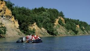

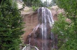
1. Residential lot sizes may vary depending upon the types of sanitarysystem installed and the source of potable water.
2. Cluster developments should be considered and used whenever soils, topography,natural amenities warrant.
3. Protection of view sheds towards and from the Niobrara River.
4. Private property rights should be considered in all land use decisions.
It is the desire of Cherry County to protect their natural resources, especiallythe Niobrara Corridor east of Valentine.
Policies
RPCLU-1.1 The County should continue to promote the recreational potential of the area and work with existing property owners to establish specific ecotourism opportunities.
RPCLU-1.2 The Niobrara River Scenic River Corridor should be protected due tothe natural amenities of the area.
RPCLU-1.3 The establishment of chemical storage facilities including the manufacturing of chemicals should not be allowed inthis area.
RPCLU-1.4 Existing uses within the Niobrara River Scenic River Corridor having a high contaminate potential should be relocated to a more suitable location when possible.
RPCLU-1.5 All new developments in the Niobrara Scenic River corridor should also comply with the standards for development and the related review procedures as set forth in the General Management Plan Environmental Impact Statement: Niobrara National Scenic River.
There is no further need for including any other WSA's or any other segments of rivers or tributaries within Cherry County in the National System of Wild and Scenic Rivers and that there are no others which meetthe standards for designation.
Policies
RPCLU-2.1 Provide for optimum scenic value in Cherry County through achievement of vegetation and soils watershed objectives and implementation of nondegrading, non-imparing range improvement activities, construction, use and maintenance of livestock management facilities, and facilities for public enjoyment of the land.
RPCLU-2.2 Management policies for the affected area must be consistent with land use plans and the non-wilderness full multiple use concept mandated by the Federal Land Policy & Management Act and Public Rangelands Improvement Act.


This policy is from the Cherry County Natural Resource and Management Plan for Federal and State Managed Lands.
In the Endangered Species Act of 1973 (as amended) the United States Congress has established it to be the national policy to maintain a balance in the ecological systems upon which human and all life depend which prevents the unnatural, unnecessary extinction of a species of fish, economic and social hardship which would lead toextinction of human activities on the other.
In 16 U.S.C. Section 1533 the Congress has specifically required the Secretary of Interior to consider "economic impact" before designating a critical habitat, all governmental agencies local, state and federal are called upon to cooperate with each other and with other interested parties to conserve the ecological systems upon which all species depend.
The specifically expressed purpose stated in 16 U.S.C., Section 1531 is to provide a legislative and financial means through which conservation of ecological systems could be maintained with such balance. The Congress declared the national purpose to be to encourage states "through Federal financial assistance and a system of incentives" to develop and maintain "conservation programs." Such programs were defined to include scientific resource management activities such as research, census, law enforcement, habitat acquisition and maintenance, propagation, live trapping, transplantation and other activities designed to bring about the balance in the ecological system which make protective actions under the Endangered Species Act no longer necessary.
Local planning must play a critical role in the development of programs, which will work toward that balance in the ecological system, which will protect all species of life, including human. In 16 U.S.C., Section 1533 (b)(1)(A) the Congress mandated that the Secretary of Interior must make his determinations to protect species "on the basis of the best scientific and commercial data
available to him, and only “after taking into account those efforts, if any, being made by any state...or any political subdivision of a state...to protect such species." The Congress declared it to be the national policy that local conservation programs, research programs and habitat maintenance programs be looked to initially as the means to achieve the balance desired in ecological systems upon which all life depends. Of particular importance in the arid lands of the Nebraska is the requirement stated in 16 U.S.C. Section 1531(c)(2) that "Federal agencies shall cooperate with State and local agencies to resolve water resource issues in concert with conservation of endangered species."
The County will expect all federal agencies to follow the mandate of the federal statutes and to consult and cooperate with the County as it implements its local responsibility in accordance withthe Endangered Species Act.
The county will protect the constitutional rights of citizens of Cherry County, from physical and economical damage resulting from illegal action or implementation of the Endangered Species Act. Also, from the harboring of and or for the release, relocation, reintroduction, and transportation of endangered species and or any other species that is detrimental or injurious to agriculture and the citizens of Cherry County.
Moreover, all federal land management agencies are advised that the County expects the federal land management agencies, in planning for the protection of any species in Cherry County, to coordinate its efforts with the County considering the specific statutory mandate of coordination set forth in 43 U.S.C. Section 1712 (c)(9).
COUNTY RESOLUTION 04-13-2021-01
WHEREAS, Cherry County, Nebraska is a legal and political subdivision of the State of Nebraska for which the Board of County Commissioners ("Board") is authorized to act; and
WHEREAS, Cherry County contains about 3,828,500 acres of land situated in West Central Nebraska ("Sandhills"); and
WHEREAS, the federal government owns approximately 207,290 Acres of land and the State approximately owns 169,665 Acres of land within the County, amounting to approximately 10% of the total land area of Cherry County; and
WHEREAS, Cherry County contains 23.7 river miles of the Niobrara National Scenic River designated in 1991; and
WHEREAS, Cherry County currently enjoys numerous privately and publicly administered parks, wildlife management area and state recreation areas, as well as some privately held in conservation easements; and
WHEREAS, Cherry County has a Natural Resource and Management Plan for Federal and State Managed Lands; and
WHEREAS, designating lands as wilderness does not assure its preservation. Left in an undisturbed or natural state, these lands are highly susceptible to wildfires, insect infestation and disease, all of which degrades the natural and human environment; and
WHEREAS, because of the predominance of federal land in Cherry County, the well- being, health, safety, welfare, economic condition, and culture of the County, its businesses, and its citizens depend on the manner in which these lands and their resources are used and access to these lands; and
WHEREAS, many of Cherry County's businesses and its citizens are involved in or otherwise depend on industries that utilize federal lands and their resources, including the forest products industry, livestock grazing, oil and gas exploration and production, mining and mineral development, recreational industries, hunting and other outdoor recreation; and
WHEREAS, these industries are important components of the Nebraska economy, and are major contributors to the economic and social wellbeing of Cherry County and its citizens; and
WHEREAS, on January 27, 2021, President Joseph R. Biden, Jr., issued Executive Order 14008 entitled Tackling the Climate Crisis at Home and Aboard (86 Fed. Reg. 7,619); and
WHEREAS, in Section 216 of Executive Order 14008, President Biden directed the Secretary of the Interior, in consultation with the Secretary of Agriculture and other senior officials, to develop a program to conserve at least 30 percent of the lands and waters in the United States by 2030, which is called the "30 x 30" program; and
WHEREAS, under the 30 x 30 program, some 680 million acres of our Nation's lands would be set aside and permanently preserved in its natural state, preventing the productive use of these lands and their resources; and
WHEREAS, there is no constitutional or statutory authority for the President, the Department of the Interior, the Department of Agriculture, or any other federal agency to set aside and permanently preserve 30 percent of all land and water in the United States, and no such authority is referenced in Executive Order 14008; and
WHEREAS, the 30 x 30 program, if implemented, is likely to cause significant harm to the economy of Cherry County, and injure the County's businesses and its citizens by depriving them of access to public lands and national forest system lands and preventing the productive use of these lands' resources; and
WHEREAS, the withdrawal of some 680 million acres of federal lands from multiple use and placement of such lands in permanent conservation status will cause dramatic and irreversible harm to the economies
of many western states, including Nebraska, and in particular rural counties such as Cherry County whose citizens depend on access to federal lands for their livelihoods; and
WHEREAS, the 30 x 30 program, if implemented, will conflict with the plans, policies and programs of Cherry County as expressed in the Cherry County Comprehensive Development Plan adopted 4/29/1997, which obligates the federal government to coordinate its policy development with Cherry County as also required by the Federal Land Management and Policy Act (FLPMA) and the National Forest Management Act (NFMA); and
WHEREAS, Executive Order 14008 at 216(a) directs the Secretary of the Interior, in consultation with other relevant federal agencies to "submit a report to the Task Force within 90 days of the date of this order recommending steps that the United States should take, working with State, local, Tribal, and territorial governments, agricultural and forest landowners, fishermen, and other key stakeholders, to achieve the goal of conserving at least 30 percent of our lands and waters by 2030."
NOW, THEREFORE, BE IT RESOLVED by the Board of County Commissioners of Cherry County, Nebraska, as follows:
1. The Board opposes the 30 x 30 program, including its objective of permanently preserving 30 percent of the Nation's lands in its natural state by 2030, or any similar program that will set aside and prevent the productive use of millions of acres of our lands.
2. The Board further opposes the designation of public lands and national forests in Cherry County as wilderness, wilderness study areas, wildlife preserves, open space, or other conservation land, thereby restricting public access to such lands and preventing the development and productive use of the resources on or within such lands.
3. The Board supports the continued management of the public lands and the national forests under principles of multiple use and sustained yield, recognizing the Nation's need for domestic sources of minerals, energy, timber, food, and fiber, and in careful coordination with Cherry County to ensure consistency with County land use plans and land management policies, as required by law.
4. The Board supports maintaining and enhancing public access to public lands and national forests and opposes road closures, road decommissioning, moratoria on road construction, and other limitations on public access for the purpose of fulfilling the 30 x 30 program's objectives.
5. The Board recognizes and supports the State of Nebraska water rights system, including the doctrine of First-in-Time, First-in-Right Rule and other state laws and programs governing water rights and water use, and opposes any federal designation of waters and watercourses within the County that would impair or restrict water diversions and uses authorized under Nebraska law.
6. The Board maintains that the designation of public lands and national forest lands as wilderness, wilderness study areas, wildlife preserves, open space, or other conservation land to fulfill the 30 x 30 program's objectives may lawfully occur, if at all, only through the planning process mandated by the Federal Land Management and Policy Act (for public lands) or the National Forest Management Act (for national forest lands) and in compliance with the Cherry County Natural Resource and Management Plan for Federal and State Managed Lands, including public notice and an opportunity to comment, analysis and disclosure of the impacts of such land acquisitions on the well-being, health, safety, welfare, economy, and culture of Cherry County, its businesses, and its citizens, and careful coordination with Cherry County to ensure consistency with County land use plans and land management policies.
7. The Board also maintains that any non-federal lands or other rights that are acquired to fulfill the 30 x 30 program's objectives should be acquired only from willing landowners and for the payment full and fair market value for all rights and interests acquired, and not through regulatory compulsion, and only after analyzing and considering the impacts of such land acquisitions on the well-being, health, safety, welfare, economy, and culture of Cherry County, its businesses, and its citizens.
8. The Board shall send a copy of this Resolution to the Department of Interior, Department of Agriculture and all other relevant Federal and State agencies.
CONSERVATION AND PRESERVATION EASEMENTS
SUBJECT TO COUNTY APPROVAL
All conservation and preservation easements are interests in real property and subject to County approval pursuant to Neb. Rev. Stat. §76-2112(3).
Conservation land-use restrictions that fall under the statutory definition of conservation and preservation easements include both permanent and temporary instruments that impose a limitation upon the rights of the owner or an affirmative obligation on the owner for conservation purposes (See Nebraska Department of Revenue November 18, 2021 FAQ, “Conservation Easements – New Application &GoverningBody Review”).
• Conservation easements are defined at Neb. Rev. Stat. §76-2,111(1) to mean, “a right, whether or not stated in the form of an easement, restriction, covenant, or condition in any deed, will, agreement, or other instrument executed by or on behalf of the owner of an interest in real property imposing a limitation upon the rights of the owner or an affirmative obligation upon the owner appropriate to the purpose of retaining or protecting the property in its natural, scenic, or open condition, assuring its availabilityfor agricultural, horticultural,forest, recreational, wildlife habitat, or open space use, protecting air quality, water quality, or other natural resources, or for such other conservation purpose as may qualify as a charitable contribution under the Internal Revenue Code.”
• Preservation easements are defined at Neb. Rev. Stat. §76-2,111(2) to mean “a right, whether stated in the form of an easement, restriction, covenant, or condition in any deed, will, agreement, or other instrument executed by or on behalf of the owner of an interest in real property imposing a limitation upon the rights of the owner or an affirmative obligation upon the owner appropriate to the purpose of preserving the historical, architectural, archaeological, or cultural aspects of real property, or for such other historic preservation purpose as may qualify as a charitable contribution undertheInternal Revenue Code.”
Those land-use conservation instruments that are subject to County approval include, but are not limited to:
• Conservation Easements in Perpetuity
• Wetlands Reserve Easements (WRE)
• Agriculture Conservation Easement Program (ACEP)
• HealthyForest Reserve Program (HFRP)
Either the land owner or easement holder can make an application to the County. This application must include a full and complete copy of the contract, including all applicable information. The application should be made prior to the easement being executed by both parties to determine whether or not it qualifies for a special use permit from the County. A “Conservation Easement Application,” prepared by the Nebraska Department of Revenue, Property Assessment Division is available from the Cherry County Assessors. This should be submitted to the Cherry County Zoning office to be reviewed by Planning Commission and Board of Commissioners.
The Planning Committee will review and make recommendations to the Board of Commissioners (BOC) within 60 days of receiving the application. If the committee fails to provide comments to the BOC within this time frame, the easement will be deemed approved by the planning committee and the issue should be reviewed bythe BOC.
The BOC may accept and approve the planning committee’s recommendation, or may return the application to the committee to address additional questions. Additionally, the BOC may make a finding contrary to the committee after carefully considering whether the application meets the criteria set forthinthe Comprehensive Plan.
If the application is approved, the BOC record of approval in the minutes will be communicated to the applicant by the Clerk of the Board. Once the easement contract is executed and signed by both parties, a complete copy of the signed contract should be reviewed by the BOC. If there are no changes, the checkbox on the application will be marked approved, and signed by the Chairman of the Board of Commissioners. The application should be filed with the Real Estate Transfer Statement (Form 521) in the Office of the Register of Deeds of the County.
If the application is denied, the checkbox indicating the denial will be marked and sent to the County Assessor for information purposes only. The County Assessor will not inventory the easement on the subject property when establishing the assessed value of the property.
An easement can be denied, pursuant to Nev. Rev. Stat. §76-2112(3), if it is inconsistent with the comprehensive plan, or any national, state or local program furthering conservation or preservation, or any known proposal by a governmental body for the use of the land. The County Zoning Administrator, Planning Commission, and/or Board of Commissioners reserve the right to review any intended conservation easement for compliance withthis Resolution and as per State Statute.
The following coordination policy adopted by Cherry County is modeled from the document entitled, “Restoring the rule of Law and Federalism by Ensuring Coordination with State and Local Governments.” This document was prepared by Chaves County, New Mexico; Garfield County, Colorado; Kane County, Utah; American Stewards of Liberty; and Norman D. James, Fennemore Craig P.C., and was advanced as a Presidential Executive Order byMembers of Congress in 2017.
1. It is in the national interest toensure that Federal departments and agencies work closely with the States and their local governments prior to making decisions and taking actions because they may have significant local and regional impacts on land and resource uses as well as State and local land use planning efforts. Local governments such as Cherry County, are important units of government charged with planning authority and the responsibility to protect the health, safety and general welfare of the citizens. Effective and meaningful coordination between Federal agencies and Cherry County is essential to maintain the proper balance between the Federal government and the States, as envisioned by the Framers of our Constitution.
2. Meaningful coordination with Cherry County is especially important when Federal departments and agencies make decisions that involve federally owned land. The Federal government owns about 207,290 acres of land in the county.
Moreover, Federal agencies often regulate aspects of land and resource uses occurring on non-Federal land. Consequently, the Federal government has tremendous impacts on State and local governments and their citizens. To minimize conflicts and support economic growth, Federal agencies should closely coordinate their land use planning and other regulatoryactions with the States and their local governments.
3. Various Federal laws and agency regulations require that Federal departments and agencies coordinate with State and local governments for the purpose of ensuring that the issues and concerns of State and local governments are addressed and that their land use planning and management activities are harmonized with the planning, and management activities of Federal agencies. These policies are intended to ensure that Federal departments and agencies recognize the important rights and interests of Cherry County under our Federal system of government and engage in effective and meaningful government-to-government coordination.
1. The Cherry County Board of Commissioners are elected representatives of the public and are authorized to carry out specific planning and governing responsibilities as expressed in their plans, policies and programs. Government-togovernment coordination shall serve as the process to harmonize Federal, State and local plans,policies and programs.
2. In accordance with State law, Cherry County often must exercise their duties through an open public process that includes public meetings and participation of the governing board. In these situations, Federal agencies are required to engage in meaningful coordination with local governments through their public meeting process. All information that may be relevant to coordinating the objectives, plans, policies and programs of Federal and local governments shall be disclosed and discussed through a public meeting process, unless doing sois precluded bylaw.
3. Coordination with Cherry County is expected to be a continuing process. When new planning efforts or policy changes are being considered, the Federal agency shall contact Cherry County to ensure the concerns of the County are identified early and are addressed as part of the decision-making process to avoid potential conflicts.
4. Prior to public comment on a plan, policy or program being developed or modified by a Federal agency, the Federal agency shall provide Cherry County with a written review document and shall incorporate into the Federal agency’s public document any determination by the County as to whether the proposed Federal action will be consistent with Cherry county’s objectives, plans, policies and programs, in accordance with section 2 of this Policy.
5. Prior to issuing a final decision on a plan, policy or program being developed or modified by a Federal agency, the Federal agency shall provide Cherry County with a written document that describes the efforts that have been made to coordinate, identifies any issues or conflicts with the County plan, policies and programs, and explains how those issues and concerns have been resolved in the final decision. Federal agencies shall make all reasonable efforts to achieve consistency between Federal, State and Cherry County’s, plans, policies and programs and to address and resolve issues and concerns raised by the County, unless precluded by Federal law.
ANAGEMENT COORDINATION POLICIES
1. The Secretary of the Interior and the heads of DOI agencies that are responsible for managing Federal land, as well as the Secretary of Agriculture and the Chief of the Forest Service with respect to National Forest System land, shall coordinate their land use inventory, planning, and management activities of or for such lands with the land use planning and management plans, policies, and programs of Cherry County within which the lands are located,unless contrarytoFederal law.
2. The Secretary of the Interior and the heads of DOI agencies that are responsible for managing Federal land, as well as the Secretary of Agriculture and Chief of the Forest Service with respect to National Forest System land, shall keep apprised of the land and resource use plans, policies, and programs of Cherry County
and fully consider those plans, policies, and programs of the County that are relevant to the development and implementation of their own land and resource use plans, policies, and programs.
3. In all cases, the plans, policies, and programs of DOI agencies and those of the Forest Service that concern the management or use of Federal land shall be consistent with the Cherry County Comprehensive plan, policies, and programs unless a Federal law specifically requires otherwise.
4. In the event of a conflict or inconsistency between a plan, policy, or program of a DOI agency or those of the Forest Service that concerns the management or use of Federal land or resources and a plan, policy, or program of Cherry County, the Federal agency shall resolve such conflict or inconsistency through government - to - government coordination with the County in accordance with section 2 of this Policy, with the goal of eliminating such conflict or inconsistency and recognizing the rights and interests of the County to plan for and manage land and resources within its jurisdiction.
1. The National Environmental Policy Act of 1969 (NEPA), 42 U.S.C. §§ 4321–4370e, and the rules of the Council on Environmental Quality (CEQ) implementing NEPA, 40 C.F.R. §§ 1500–1508, require Federal agencies to consider State and local governments’ position on proposed Federal actions and to identify and avoid conflicts with State and local government objectives, plans, policies, and controls for the area concerned.
2. To facilitate coordination with Cherry County during the NEPA process, Federal agencies, when considering an action that might be considered a major Federal action within the meaning of NEPA, shall do the following: a. Provide written notification to Cherry County of the proposed Federal action, along with a schedule of anticipated events, and invite the County to coordinate on the proposed Federal action, at the beginning of the NEPAprocess in accordance with section 2.
b. The Federal agency shall review the land and resource use objectives, plans, policies, and programs of Cherry County. The results of this review shall be disclosed and discussed in the draft and final environmental analysis. The review shall include:
i. Consideration of the objectives of Cherry County, as expressed in the Comprehensive plans, policies, and programs;
ii. An assessment of the interrelated impacts of these plans, policies, and programs,including any conflicts;
iii. A determination of how the proposed Federal action should be modified to addressthe impacts identified;and,
iv. Where conflicts are identified, consideration of alternatives for their resolution.
c. Facilitate and document all in-person meetings or other forms of communication, with Cherry County on the proposed Federal action, including, where necessary, open meetings that allow the full participation of the governing board in the coordination process,as required by State law.
d. Document all relevant issues, concerns, or requests for additional information communicated by Cherry County during coordination, including any conflicts or inconsistencies between the proposed Federal action and any land and resource use plans, policies, and programs of the County.
e. Prepare a written report that discusses how the issues and concerns were addressed during the coordination process, including an explanation of how any conflicts or inconsistencies with any land and resource use plans, policies, and programs of Cherry County were resolved prior to finalizing the proposed Federal action.
f. Provide follow-up communication with Cherry County explaining how substantive issues and concerns, including any conflicts or inconsistencies with any land and resource use plans, policies, and programs of the County, were resolved prior to finalizingthe proposed Federal action.
g. Include in the Federal agency’s record of decision or equivalent NEPA document a discussion of all relevant issues and concerns communicated by Cherry Countyduring the coordination process and how those issues
and concerns were addressed prior to the final decision, including a discussion of how any conflicts or inconsistencies with a land and resource use plan, policy, or program of the Countywere resolved.
3. To ensure that the coordination process is properly completed, each Federal agency shall appoint an official who is responsible for ensuring that meaningful and effective government-to-government coordination is completed in advance of the Federal agency’s completion of the NEPA process and the final agencydecision.
For the purposes of this Policy:
“State”' or “States”' refer to the States of the United States of America, individually or collectively, and, where relevant, to State governments, including units of local government and other political subdivisions established bythe States.
“Local government” or “local governments” refer to the duly organized and legally recognized units of local government and other political subdivisions established by a State, such as Cherry County, whose powers and duties are germane to the proposed Federal action.
“Plans, policies, and programs” means the whole or a part of a statute, law, rule, regulation, ordinance, policy, plan, resolution, or other document of a State or local government that has been adopted by the entity’s governing body, is currently in effect, andsetsforth theentity’sofficial position.
“Agency” or “agencies” means any authority of the United States that is an “agency” under 44 U.S.C. § 3502(1), other than those agencies considered to be independent regulatory agencies under 44 U.S.C.§ 3502(5).
“Coordinate” and “coordination” refer to government-to-government oral and written communications between the authorized representatives of a Federal agency and the elected officials of a State or local government or their duly authorized representatives that are intended, in good faith, to identify, consider and resolve issues and concerns of a State or local government about a proposed Federal action, including conflicts with plans, policies, and
programs of a State or local government. Coordination means the responsibilities of each government entity are equal, not subordinate, and therefore must be harmonized for effective governance. “Coordinate” and “coordination” do not include participation in the NEPA process as a cooperating agency or the submission of comments to a Federal agency during a public comment period.
This land use area is identified for the protection of public water supplies. These areas are identified but will not be strictly enforced through zoning until an interlocal agreement is approved by the county and other partyowningthe wellhead.
These areas are considered as overlays and are in addition to the requirements and policies of the underlying area.
Typical Uses
Use allowed in the underlying area that are not considered a contamination hazard to the wellhead area andthewater supply.
Potential Issues to Consider
See underlying land use category.
Buildable Lot Policies
See underlying land use category.
Development Policies to Consider
See underlying land use category.
The Growth and Development policies are for the purpose of guiding future growth and development in Cherry County in order to insure compatible uses are located together as appropriate.
General Land Use Policies and Strategies
GENLU-1.1 Future land uses in the county should carefully consider the existing natural resources of the area, including soils, rivers,and groundwater.
GENLU-1.2 Cherry County should consider limited future commercial and industrial development to identified areas along the major highways spanning the county.
GENLU-1.3 The Cherry County Land Use Plan and Zoning Regulations should be designed to expedite the review and approval processwhere possible.
GENLU-1.4 All livestock production should be protected from the establishment of conflicting usessuch as acreages.
GENLU-1.5 Cherry County should encourage uses referredtoas“Agri-tourism”.
Residential Land Use Goal
Residential development should occur within the communities of the countyunless a residence(s) are part of a farming and ranching operation.
Residential Land Use Policies
RESLU-1.1 Ideally, new residential development within Cherry County should be focused on the communities of the county; except for those still farming in the county. Large residential subdivisions should be located next to or near the communities within Cherry County.
RESLU-1.2 Residential developments should be separated from more intensive uses, such as agriculture, industrial, and commercial development, by the use of setbacks, buffer zones, or impact easements.
RESLU-1.3 Encourage low to zero non-farm densities in Cattle Countryareas.
RESLU-1.4 Any new lots or tracts created should have a minimum area of 2 1⁄2 acres with a maximum lot depth to width ratio of 3 to1.
RESLU-1.5 All proposed rural area developments
should be based on reasonable expectations and no large-scale development should be approved without:
1. The submission and approval of a layout and design concept, with provision for the staging and servicing of all phases of the development;
2. The approval of all federal and state agencies relative in any applicable health, safety and environmental controls;and
3. Should not be located in any natural hazard area.
4. Should be furnished with adequate access – when possible a minimum of twoentrances and exits.
RESLU-1.6 New residential construction or relocations should not be allowed along any minimum maintenance road unless the road is upgraded to county specifications and paid for by the propertyowner,prior to construction.
Utilize, to the greatest extent possible, agricultural entry, land exchange, and or land sale for disposal of all public lands which by virtue of their size or location render them difficult and expensive to manage and do not serve a significant public need or where disposal will serve important public objectives. Authorize as needed the use of those lands, not currently authorized, for rights-of-way, leasesand permits.
PLUI-1.1 Identify and give priority consideration to requests for exchanges or purchases from private landowners with fenced federal range, isolated tracts,or irregular boundarylines.
Provide for multiple recreation uses in Cherry County including all federal land management agency's administered lands located within its boundaries, including high quality recreational opportunities and experiences at developed and undeveloped recreation sites by allowing historic uses and access while maintaining existing amenities and by providing new recreation sites for the public's enjoyment. Pursue increased public access opportunities in both motorized and nonmotorized settings. Recognize that multiple
recreation uses are mandated by the multiple use concept and that adequate outdoor recreation resources must be provided on all federal land management agency's administered lands and waterways.
PLRU-1.1 Provide for continued multiple recreation uses in special and extensive recreation management areas, including those areas where state, federal and/or private funds and materials were or are considered to be used toprovide for recreational facilities.
PLRU-1.2 In compliance with applicable local, state and federal laws, identify specific areas for: additional trailhead facilities for both motorized and non-motorized access, development and/or maintenance of roads, trails, and waterways for both motorized and nonmotorized access, restoration of those areas formerly available for historical recreational uses, e.g. motorized and equestrian access for recreational and competitive events, hunting and boating.
PLRU-1.3 Provide for adequate outdoor recreation resources by revising the designated areas to decrease or eliminate limitations and restrictions where the review and evaluation shows that the limitations and restrictions are nolonger appropriate and necessary.
Maintain, improve, or mitigate habitat in order to sustain viable and harvestable populations of big game and upland game species as well as wetland/riparian habitat for waterfowl, furbearers and a diversity of other game and non-game species.
Policies
NR-1.1 Consult with the Nebraska Game and Parks Commission all affected landowners, lessees and permitters to develop specific wildlife population targets, harvest guidelines, depredation mitigation and guidelines for future sitespecific management plans affecting upland, water fowl and big game habitat.


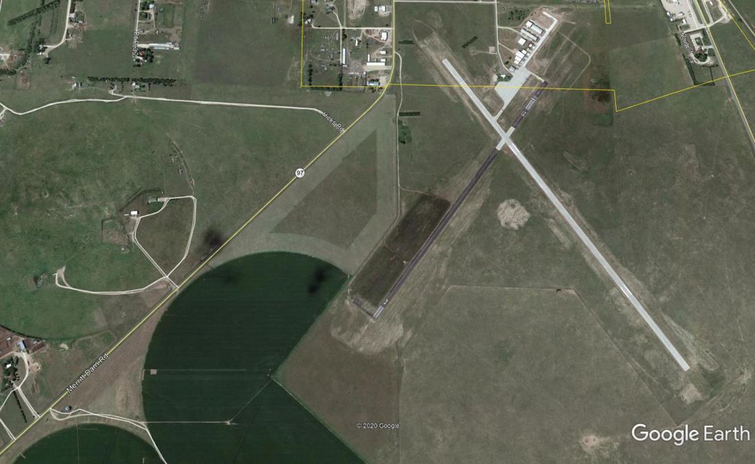
Transportation networks the communities together as well as providing a link to the outside world. Adequate circulation systems are essential for the safe and efficient flow of vehicles and pedestrians, and accessibility to all parts of the community. The Transportation Plan will identify existing systems and any major improvements planned for the future and those necessary to provide safe and efficient circulation of vehicles within Cherry County, including major projects that ensure implementation of the Land Use Plan.
Residents within a county have specific transportation needs. These include rail service, bus service, air transportation, as well as vehicular transportation. All of the transportation facilities present are not available within the county and require residents to travel to the nearest location. This portion of the Comprehensive Development Plan examines those services with regard to the closest proximityfor residents of Cherry County.
The closest rail freight service to Cherry County is in either Norfolk through the Nebraska Central Railroad or Alliance via the BNSF. The nearest
passenger service is located in McCook through Amtrak.
The nearest commercial bus service with ticketing services is available in North Platte and Norfolk via Arrow Stage Lines and North Platte for Greyhound or Grand Island, Kearney, or Lexington for Burlington Trailways.
North Platte Regional Airport in North Platte is the nearest commercial facility to residents in Cherry County. However, arrivals and departures are limited to one major airline. Currently, the airport and commercial service connects people to Denver and points across the U.S. through Denver International Airport via United Airlines.
The Valentine Miller Airport is the only public airport in Cherry County for small aircraft. Runway #14/32 is 4703 feet by 75 feet with concrete surfacing. However, the northern 384 feet of the runway is considered displaced. The crosswind runway is #03/21. This runway is 3700 feet long by 60 feet wide with the northern 300 feet designated as displaces.The surface of this runwayis asphalt.
The fixed based operator (FBO) for this facility is Sandhills Aero.Elevation is listed at 2,591 feet.
Cherry County has six major highways running through the county. The major north-south highways are US Highway 83, Nebraska Highway 61, 97, and S16F. US Highway 20 and Nebraska Highway12 are east and west highways.
Land use and transportation create the pattern for future development and are extremely interdependent upon one another in order to effectively shape the community. An improved or new transportation route generates a greater level of accessibility and will likely determine how adjacent landwill be utilized in the future.
In the short term, land use shapes the demand for transportation and vice versa; one key to good land use planning is to balance land use and transportation. However, new or improved roads, as well as, county and state highways may change land values, thus altering the intensity of which land is utilized.
In general, the greater the transportation needs of a particular land use, the greater its preference for a site near major transportation facilities. Commercial activities are most sensitive to accessibility since their survival often depends upon how easy a consumer can get tothe business. Thus, commercial land uses are generally located near the center of their market area and along highways or at the intersection of arterial streets.
Industrial uses are also highly dependent on transportation access, but in a different way. For example,visibilityis not as critical for an industryas it is for a retail store. Industrial uses often need access to more specialized transportation facilities, which is why industrial sites tend to be located near railroad lines or highways tosuit individual industrial uses.
All of the public highways, roads, and streets in Nebraska are divided into two broad categories, and each category is divided into multiple functional classifications. The two broad categories are Rural Highways and Municipal Streets. State statute defines Rural Highways as “all public highways and roads outside the limits of any incorporated municipality,” and Municipal Streets as “all public streets within the limits of any incorporated municipality.” Neb. Rev. Stat. § 392102 (RRS 1998).
Nebraska Highway Law (Chapter 39, Article 21, Revised Reissue Statutes of Nebraska 1943) proposes the functional classification of both rural and municipal roads and streets and public highways. Chapter 39, Article 21.03 lists rural highwayclassifications as:
1. Interstate: federally-designed National System of Interstate and defense highways;
2. Expressway: second in importance to Interstate. Consists of a group of highways following major traffic desires in Nebraska and ultimately should be developed to multiple divided highway standards;
3. Major Arterial: consists of the balance of routes that serve major statewide interests for highway transportation in Nebraska. Characterized by high speed, relatively long distances, travel patterns;
4. Other Arterial:consists of a group of highways of lessimportance as through- travel routes.
5. Collector: consists of a group of highways that pick up traffic from the local or land- service roads and transport community centers or to the arterial systems. Main school bus routes, mail routes,and farm-to- market routes;
6. Local: consists of all remaining rural roads, generally described as land-access roads providing service to adjacent land and dwellings;and
7. Bridges: structures crossing a stream three hundred feet or more in width or channels of such a stream having a combined width of three hundred feet or more.


Traffic flow within the county on these highways varies considerably.
Figure 12.2 indicates the greatest traffic flows are along US Highway 83 south out of Valentine. US Highway 83 has an average daily traffic count, south of Valentine, of between 1550 vehicles and 1805 vehicles. However, the short segment heading north from Valentine has an average daily traffic county2700 vehicles.
FIGURE 12.2: TRAFFIC FLOW MAP
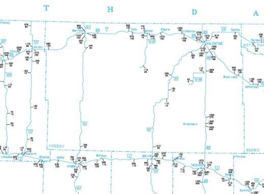
Source: Nebraska Department of Transportation
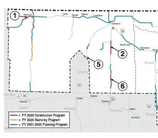
Source: Nebraska Department of Transportation
US Highway 20 carries the second greatest amount of traffic. Its count is 920 vehicles daily on the east edge of Cherry County and 880 vehicles on the west side. The greatest amount of traffic occurs around Valentine where US Highways 20 and 83 and Nebraska Highways 12 and 97 all come together.
The Nebraska Department of Transportation publishes an annual list of proposed projects for the current fiscal year, for fiscal years one to five years from the present, and six years and beyond. Cherry County is split into two different districts, the Department of Transportation’s District 6 and 8.District 8 covers most of Cherry County. Between Fiscal Years 2020 and 2025, there are 17 projects budgeted for the Cherry County area (all within District8.These projects include:
• US Highway 20 Merriman West and Niobrara River North and South - Microsurfacing ($3,800,000)
• US Highway 20 S-16B North and SouthMicrosurfacing ($1,017,000)
• Nebraska 97 Alkali Pond - Culvert ($183,000)
• US Highway 83 North of Thomas/Cherry County line North - Microsurfacing ($716,000)
• Nebraska 61 Snake River North and South - Mill and resurface ($7,993,000)
• Nebraska 16B Hackberry Lake NortheastResurfacing ($2,600,000)
• Nebraska 12 Minnechaduza Creek - Bridge ($2,290,000)
• Nebraska 12 Sparks East - Resurfacing ($1,660,000)
• US Highway 20 Valentine Area - Microsurfacing ($3,980,000)
• US Highway 20 Merriman Area – Microsurfacing ($1,560,000)
• US Highway 20 Wood Lake and Bassett AreaMicrosurfacing ($2,750,000)
• Nebraska 61 Grant/Cherry County line NorthMill and Resurfacing ($2,990,000)
• Nebraska 61 Snake River-Niobrara River - Mill and Resurfacing ($3,650,000)
• US Highway 83 In Valentine - Urban, Resurfacing, and Bridge ($7,230,000)
• US Highway 83 West 4th Street in ValentineConcrete pavement ($3,650,000)
• Nebraska 97 Merritt Reservoir North - Mill and Resurfacing ($2,360,000)
Overall the Nebraska Department of Transportation is expecting to spend over $48,429,000 in upgrades in the CherryCountyover the next six years.
TRANSPORTATION GOALS
TRANSPORTATION POLICIES AND STRATEGIES
TRAN-1.1 Development should be discouraged from occurring in areas where the road system is insufficient to handle any additional traffic load without upgrades being completed.
TRAN-1.2 Cherry County should require new development to:
1. Limit access points on highways designated as arterials when alternative access points are feasible.
2. Minimize direct access points onto arterial rights-of-way by encouraging the utilization of common driveways.
3. New development should not be located along roads officially designated as “ Minimum Maintenance”


Successful community plans have the same key ingredients: "2% inspiration and 98% perspiration." This section of the plan contains the inspiration of the many county officials and residents who have participated in the planning process. However, the ultimate success of this plan remains in the dedication offered by each and everyresident.
There are numerous goals and objectives in this plan. We recommend reviewing the relevant goals during planning and budget setting sessions to determine what projects may need to be undertaken during the course of the fiscal year.
The Action Agenda is a combination of the following:
• Goals and Objectives
• Land Use Policies
• Support programs for the above items
• Cherry County: Natural Resource and Management Plan for Federal and State Managed Lands
It will be critical to earmark the specific funds to be used and the individuals primarily responsible for implementing the goals and objectives in Cherry County.
SUPPORT PROGRAMS FOR THE ACTION AGENDA
Four programs will play a vital role in the success of CherryCounty’splan.Theseprogramsare:
1. Zoning Regulations updated land use districts can allow the county to provide direction for future growth.
2. Subdivision Regulations establish criteria for dividing land into building areas, utility easements, and streets. Implementing the Transportation Plan is a primary function of subdivision regulations.
3. Plan Maintenance an annual and five-year review program will allow the county flexibility in responding to growth and a continuous program of maintaining the plan's viability.
4. Strategic Plan – A Strategic Plan will assist in identifying future economic development strategies that will tie into the overall planning effort of the county. It will be critical to work withthis document and the Plan in unison.
If major new, innovative development and/or redevelopment opportunities arise which impact any number of elements of the plan and which are determined to be of importance, a plan amendment may by proposed and considered separate from the Annual Review and other proposed Comprehensive Plan amendments. The Comprehensive Plan amendment process should adhere to the adoption process specified by Nebraska law and provide for the organized participation and involvement of citizens.
The interpretation of the Comprehensive Plan should be composed of a continuous and related series of analyses, with references to the goals and policies, the land use plan, and specific land use policies. Moreover, when considering specific proposed developments, interpretation of the Comprehensive Plan should include a thorough review of all sections of the Comprehensive Plan.
If a development proposal is not in conformance or consistent with the policies developed in the Comprehensive Plan, serious consideration should be given tomaking modifications tothe proposal or the following criteria should be used to determine if a Comprehensive Plan amendment would be justified:
• the character of the adjacent area
• the zoning and uses on nearbyproperties
• the suitability of the property for the uses allowed under the current zoning designation
• the type and extent of positive or detrimental impact that may affect adjacent properties, or the countyat large,if the request is approved
• the impact of the proposal on public utilities and facilities
• the length of time that the subject and adjacent properties have been utilized for their current uses
• the benefits of the proposal to the public health, safety, and welfare compared to the application.
• the hardship imposed on the applicant if the request is not approved
• comparison between the existing land use plan and the proposed change regarding the relative conformance tothe goals and policies
• consideration of County staff recommendations


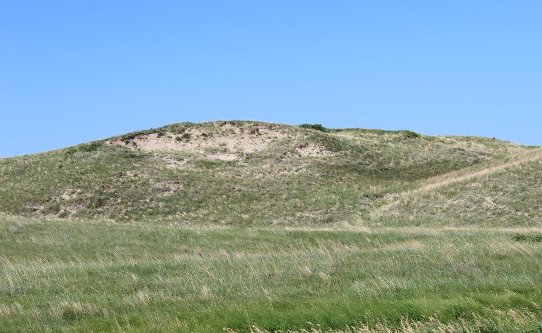

SERVICE INFORMATION
The following definitions are how the Natural Resources Conservation Service use these terms.
Available water capacity: (available moisture capacity). The capacity of soils to hold water available for use by most plants. It is commonly defined as the difference between the amount of soil water at field moisture capacity and the amount at wilting point. It is commonly expressed as inches of water per inch of soil. The capacity, in inches, in a 60-inch profile or to a limiting layer is expressed as:
Very low ....................................................... 0 to 3
Low .............................................................. 3 to 6
Moderate .................................................... 6 to 9
High ............................................................ 9 to 12
Very high ......................................... more than 12
Permeability: The quality of the soil that enables water or air to move downward through the profile. The rate at which a saturated soil transmits water is accepted as a measure of this quality. In soil physics, the rate is referred to as “saturated hydraulic conductivity,” which is defined in the “Soil Survey Manual.” In line with conventional usage in the engineering profession and with traditional usage in published soil surveys, this rate of flow continues to be expressed as “permeability.” Terms
describing permeability, measured in inches per hour, are as follows:
Extremely slow .............................. 0.0 to 0.01 inch
Very slow ..................................... 0.01 to 0.06 inch
Slow................................................ 0.06 to 0.2 inch
Moderately slow ............................. 0.2 to 0.6 inch
Moderate ............................ 0.6 inch to 2.0 inches
Moderately rapid ........................ 2.0 to 6.0 inches
Rapid ........................................... 6.0 to 20 inches
Very rapid ............................ more than 20 inches
These four Predominate Soils Series occupy 87.6 % of Cherry County. For detailed,site-specific soils information, contact the local Natural Resources Conservation Service office.
Valentine Series
Drainage class:Excessivelydrained
Permeability: Rapid (6 to 20 inches per hour)
Landscape/Landform: Interdunes, dunes and valley sides on sandhills
Slope range:0 to80 percent
Surface runoff: Negligible to low depending on slope
Major uses:Livestock grazing
Ipage Series
Drainage class:Moderatelywell drained
Permeability:Rapid (6 to 20 inches per hour) Landscape/Landform: Sandhills,interdunes
Slope range:0 to6 percent
Surface runoff: Negligible
Major uses: Livestock grazing with a few areas cultivated or hayed
Els Series
Drainage class: Somewhat poorlydrained
Permeability:Rapid (6 to 20 inches per hour)
Landscape:Sandhills,some on stream valleys
Landform: Mostly swales and hummocks on interdunes,some on stream terraces
Slope range:0 to3 percent
Surface runoff: Negligible
Major uses: Livestock grazing and haying, few areas cultivated andirrigated
McKelvie Series
Drainage class:Excessivelydrained
Permeability:Rapid (6 to 20 inches per hour)
Landscape:Valleysides
Landform: Backslopes, foot slopes and toe slopes of valleysides
Slope range:0 to80 percent
Surface runoff:low toveryhigh
Major uses:Native grasses and trees
The characteristics of soils play a major role in determining the potential compatibility of certain uses on the land. The ability to absorb certain liquids such as water and wastewater are different for certain types of soils. In addition, how sensitive an area is to erosion or how shallow the soils are in an area can have a major impact on the ability to develop a specific area of Cherry County. These conditions and how they factor into a soils ability to support certain types of uses is referred to limitations.
Finally, if a soil has some level of limitation, it does not mean the different land uses cannot be undertaken in those soils. However, the key focus needs to be on the types of special engineering solutions needing to be implemented in order to overcome these specific soil limitations.
The interpretations are based on the engineering properties of soils, on test data for soils in the survey area and others nearby or adjoining, and on the experience of engineers and soil scientists familiar with the soils of Cherry County.
Soil limitations are indicated by the ratings Not Limited, Somewhat Limited, and Very Limited.
Not Limited means soil properties are generally favorable for the stated use, or in other words, that limitations are minor and easily overcome.
Somewhat Limited means some soil properties are unfavorable but can be overcome or modified by special planning and design.
Very Limited means soil properties may be so unfavorable and difficult to correct or overcome as to require various degrees of soil reclamation, special designs, or intensive maintenance.
A map in these Appendices shows the soil suitability conditions for constructing dwelling without a basement (slab on-grade construction). In addition Table A.1 provides the suitability by soil types and the specific conditions impactingthe soil.
Based on Table A.1, about half of the soils in Cherry County are considered Very Limited for a Dwelling Unit without a Basement. There are eight major conditions impacting the soils (not all eight are present in any one soil type). The conditions present in the different soils are:
• Ponding
• Depthtosaturation zone
• Slope
• Flooding
• Organic Matter Content
• Shrink-Swell
• DepthtoSoft Bedrock
• Subsidence Risk
Again, these conditions may or may not eliminate the ability of a land owner to build a slab-on-grade dwelling unit, but specific conditions will need tobe engineered to overcome potential problems in the future.
Besides the Severe soils, there are some soils considered Somewhat Limited which is less of an issue when developing. The conditions creating the Somewhat Limited classification are:
• Slope
• DepthtoSoft Bedrock
• Depthtosaturation zone
A map in these Appendices shows the soil suitability conditions for constructing Dwellings with basements. In addition Table A.1 provides the suitability by soil types and the specific conditions impacting the soil.
Very Limited Conditions
Based on Table A.1, the Very Limited conditions are very similar to Dwellings without Basements. As noted above, a majority of the soils in Cherry County are considered Very Limited for a Dwelling Unit with a Basement. There are eight major conditions impacting the soils (not all eight are present in any one soil type). The conditions present in the different soils are:
• Ponding
• Depthtosaturation zone
• Shrink-swell
• Organic Matter Content
• Subsidence Risk
• DepthtoSoft Bedrock
• Slope
• Flooding
Again, these conditions may or may not eliminate the ability of a land owner to build a dwelling unit, but specific conditions will need to be engineered to overcome to eliminate potential problems in the future.
Somewhat Limited Conditions
There are fewer Somewhat Limited rated soils having fewer issues when developing. The conditions creating the Somewhat Limited classification are:
• Slope
• DepthtoSoft Bedrock
• Depthtosaturation zone
• Flooding
• Shrink-swell
A map in these Appendices shows the soil suitability conditions for placement of a septic tank and absorption field in Cherry County. Table A.1 provides the suitability by soil types and the specific conditions impacting the soil.
Based upon the Table A.1, there are nine conditions impacting the use of septic tanks and absorption fields in Cherry County. The major conditions impacting the soils are:
• Ponding
• Depth to saturated zone
• Flooding
• Seepage
• Filtering Capacity
• DepthtoBedrock
• Slow water movement
• Slope
• Subsidence Risk
Again, these conditions may or may not eliminate the ability of a land owner to use a septic tank and absorption field but specific conditions will need to be engineered to overcome to eliminate potential problems in the future.
Somewhat Limited Conditions
The issues present creating Somewhat problems for septic tanks are:
• Depth to saturated zone
• Slow water movement
• DepthtoBedrock
• Seepage
• Filtering Capacity
• Ponding
A map in these Appendices shows the soil suitability conditions for placement of Sewage Lagoons in Cherry County. Table A.1 provides the suitability by soil types and the specific conditions impacting the soil.
Based on Table A.1, there are seven conditions impacting the use of sewage lagoons in Cherry County. The major conditions impacting the soils are:
• Ponding
• Depth to saturated zone
• DepthtoSoft Bedrock
• Flooding
• Organic Mater Content
• Seepage
• Slope
Again, these conditions may or may not eliminate the ability of a land owner to use a sewage lagoon but specific conditions will need to be engineered to overcome to eliminate potential problems in the future.
Besides the Very Limited soils, there are some soils considered Somewhat Limited which is less of an issue when developing. The conditions creating the Somewhat Limited classification are:
• Ponding
• Depth to saturated zone
• DepthtoSoft Bedrock
• Slope
• Seepage
Again, these conditions may need special engineering to overcome to eliminate potential problems in the future.
A map in these Appendices shows the soil suitability conditions for placement of sanitary landfills in Cherry County. Table A.1 provides the suitability by soil types and the specific conditions impacting the soil.
Based on Table A.1, there are seven conditions impacting the use of sanitary landfills in Cherry County. The major conditions impacting the soils are:
• Ponding
• Depth to saturated zone
• Slope
• Flooding
• Seepage
• DepthtoBedrock
• Dusty
Again, these conditions may or may not eliminate the ability of a land owner to use a sanitary landfill but specific conditions will need to be engineered to overcome to eliminate potential problems in the future.
Besides the Very Limited soils, there are some soils considered Somewhat Limited which is less of an issue when developing. The conditions creating the Somewhat Limited classification are:
• Dusty
• Slope
Again, these conditions may need special engineering to overcome to eliminate potential problems in the future.
A map in these Appendices shows the soil suitability conditions for placement of small commercial businesses in Cherry County. Table A.1 provides the suitability by soil types and the specific conditions impacting the soil.
• Ponding
• Depth to saturated zone
• Shrink-swell
• Organic Mater Content
• Subsidence Risk
• Flooding
• Slope
Again, these conditions may or may not eliminate the ability of a land owner to use a small commercial buildings but specific conditions will need to be engineered to overcome to eliminate potential problems in thefuture.
Besides the Very Limited soils, there are some soils considered Somewhat Limited which is less of an issue when developing. The conditions creating the Somewhat Limited classification are:
• Slope
• Depth to saturated zone
• Shrink-swell
• DepthtoSoft Bedrock
Again, these conditions may need special engineering to overcome to eliminate potential problems in the future.
Based on Table A.1, there are seven conditions impacting the use of small commercial buildings in Knox County. The major conditions impacting the soils are:
Depth to saturated zone refers to soils which do not drain well or have a low permeability. This conditions creates an above average existence of wet soils.
Depth to Bedrock means typically a soil that has limited distance to bedrock of some kind.
Depth to Soft Bedrock means bedrock that can be excavated with trenching machines, backhoes, small rippers, and other equipment commonly used in construction.
Flooding is defined as soils located in areas which are prone to flooding.
Poor Filter means soils with rapid permeability or an impermeable layer near the surface, the soil may not adequately filter effluent from a waste disposal system.
Slow water movement means soils that do not allow reasonable downward movement of water.
Slope means the inclination of the land surface from the horizontal. Within Knox County the class of slopes are: Nearly level 0 to 1 percent
0 to 2 percent
Very gently sloping 1 to 3 percent
Gently sloping
Strongly sloping
2 to 6 percent
3 to 6 percent
6 to 9 percent
6 to 11 percent
Moderately sloping 9 to 20 percent
11 to 15 percent
Steep 15 to 30 percent
Seepage means the movement of water through the soil. Seepage adversely affects the specified use.
Shrink-swell means the shrinking of soil when dry and swelling when wet. Shrinking and swelling can damage roads, dams, building foundations, and other structures. It can also damage plant roots.
Subsidence means the sudden sinking or gradual downward settling of the ground's surface with little or no horizontal motion.
Depth to saturated zone refers to soils which do not drain well or have a low permeability. This conditions creates an above average existence of wet soils.
Depth to Bedrock means typically a soil that has limited distance to bedrock of some kind.
Depth to Soft Bedrock means bedrock that can be excavated with trenching machines, backhoes, small rippers, and other equipment commonly used in construction.
Flooding is defined as soils located in areas which are prone to flooding.
Poor Filter means soils with rapid permeability or an impermeable layer near the surface, the soil may not adequately filter effluent from a waste disposal system.
Slow water movement means soils that do not allow reasonable downward movement of water.
Slope means the inclination of the land surface from the horizontal. Within Knox County the class of slopes are: Nearly level 0 to 1 percent 0 to 2 percent
Very gently sloping 1 to 3 percent
Gently sloping
2 to 6 percent
3 to 6 percent
Strongly sloping 6 to 9 percent
6 to 11 percent
Moderately sloping 9 to 20 percent
11 to 15 percent
Steep 15 to 30 percent
Seepage means the movement of water through the soil. Seepage adversely affects the specified use.
Shrink-swell means the shrinking of soil when dry and swelling when wet. Shrinking and swelling can damage roads, dams, building foundations, and other structures. It can also damage plant roots.
Subsidence means the sudden sinking or gradual downward settling of the ground's surface with little or no horizontal motion.


LIST OF MAPS

A.1 CherryCountyFire Districts
A.2 Wetlands
A.3 All Soils
A.5 Slopes
A.4 Floodwayand Floodplain
Freshwater Emergent Wetland
Freshwater Forested/Shrub Wetland
Freshwater Pond Lake Riverine


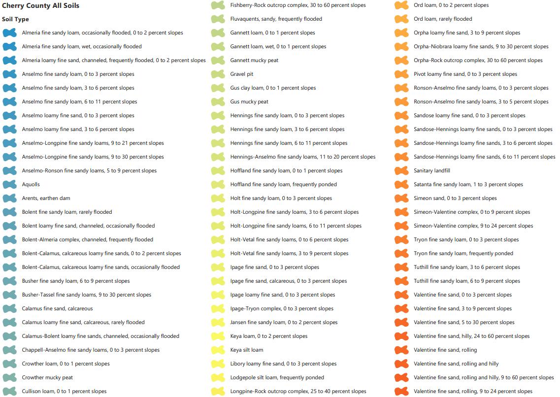
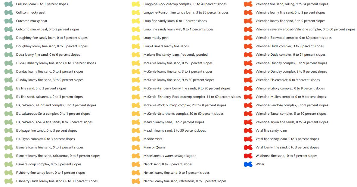


Soils - Dwellings with Basements
Not limited
Somewhat limited
Very limited
Not rated

Soils - Dwellings without Basements
Not limited
Somewhat limited
Very limited
Not rated

Somewhat limited
Very limited
Not rated


