
1. ADDRESS OF HISTORIC RESOURCE (must comply with an Office of Property Assessment address)
Street address: __________________________________________________________________
Postal code: ______________
2. NAME OF HISTORIC RESOURCE
Historic Name: __________________________________________________________________
Current/Common Name:
3. TYPE OF HISTORIC RESOURCE

4. PROPERTY INFORMATION
Condition: excellent good fair poor ruins
Occupancy: occupied vacant under construction unknown
Current use:
5. BOUNDARY DESCRIPTION
Please attach a narrative description and site/plot plan of the resource’s boundaries.
6. DESCRIPTION
Please attach a narrative description and photographs of the resource’s physical appearanc e, site, setting, and surroundings.
7. SIGNIFICANCE
Please attach a narrative Statement of Significance citing the Criteria for Designation the resource satisfies Period of Significance (from year to year): from _________ to _________
Date(s) of construction and/or alteration:______________________________________________
Architect, engineer, and/or designer:_________________________________________________
Builder, contractor, and/or artisan:___________________________________________________
Original owner:__________________________________________________________________
Other significant persons:
CRITERIA FOR DESIGNATION:
The historic resource satisfies the following criteria for designation (check all that apply):
(a) Has significant character, interest or value as part of the development, heritage or cultural characteristics of the City, Commonwealth or Nation or is associated with the life of a person significant in the past; or,
(b) Is associated with an event of importance to the history of the City, Commonwealth or Nation; or,
(c) Reflects the environment in an era characterized by a distinctive architectural style; or,
(d) Embodies distinguishing characteristics of an architectural style or engineering specimen; or,
(e) Is the work of a designer, architect, landscape architect or designer, or engineer whose work has significantly influenced the historical, architectural, economic, social, or cultural development of the City, Commonwealth or Nation; or,
(f) Contains elements of design, detail, materials or craftsmanship which represent a significant innovation; or,
(g) Is part of or related to a square, park or other distinctive area which should be preserved according to an historic, cultural or architectural motif; or,
(h) Owing to its unique location or singular physical characteristic, represents an established and familiar visual feature of the neighborhood, community or City; or,
(i) Has yielded, or may be likely to yield, information important in pre-history or history; or
(j) Exemplifies the cultural, political, economic, social or historical heritage of the community.
8. MAJOR BIBLIOGRAPHICAL REFERENCES
Please attach a bibliography.
Nominator is is not the property owner.
PHC USE ONLY
Date of Notice Issuance: _________________________________________________________________ Property Owner at Time of Notice:
Date(s) Reviewed by the Committee on Historic Designation:____________________________________
Date(s) Reviewed by the Historical Commission: Date of Final Action: __________________________________________________________
ARST-302: Uncovering the Past
May 4, 2023
Nomination of Historic Building – Philadelphia Register of Historic Places
3565 Freeland Avenue, Philadelphia PA 19128
5. Boundary Description
This nomination proposes to designate the property and house currently located at 3565 Freeland Avenue (Registry Plan No. 096N070 and Lot No. 0119). The following boundaries reflect the historic dimensions of 3656 Freeland Avenue, otherwise known as the Harmer House:
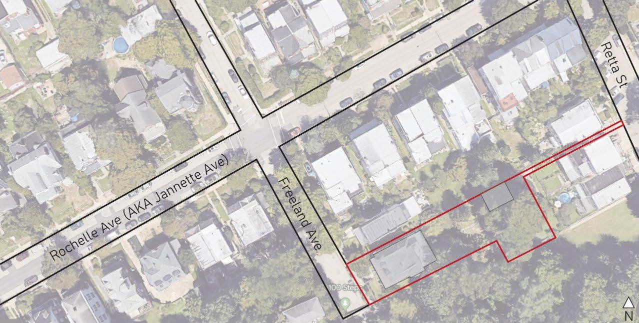
Beginning at a point on the Northeast side of Freeland Avenue at the distance of 140 feet
Southeastward from the Southeast side of Rochelle Avenue; thence North 67 degrees 22 minutes 30 seconds East 320 feet to a point in the Southwest side of Retta Street; thence South 22 degrees 37 minutes 30 seconds East along said Retta Street 08 feet to a point; thence South 67 degrees 22 minutes 30 seconds West 100 feet to a point; thence South 22 degrees 37 minutes 30 seconds East 77 feet to a point; thence again South 67 degrees 22 minutes 30 seconds West 59 feet 9-1/8 inches to a point; thence North 22 degrees 37 minutes 30 seconds West 22 feet 06 inches to a point; thence again South 67 degrees 22 minutes 30 seconds West 117 feet 6-3/4 inches to a point; thence South 73 degrees 47 minutes 30 seconds West 42 feet 11-3/8 inches to a point in the Northeast side of the said Freeland Avenue; and thence North 22 degrees 37 minutes 30 seconds West along said Freeland Avenue 57 feet 8-3/8 inches to the first mentioned point and place of beginning. 1
Figure 1: Google Maps satellite view of property with property boundary for 3565 Freeland Avenue outlined in red. 1 City of Philadelphia, PhilaDox EWeb, Doc #53071436, 5/12/2016.6. Physical Building Description
Harmer House stands tall above the street level of Freeland Avenue. This grand three-story, freestanding, Queen Anne style red brick home, with a mansard roof and rounded corner turret, defines a corner of the neighborhood that acts as a boundary point between the Wissahickon neighborhood and Fairmount Park, specifically where the Wissahickon bike trail runs parallel to the Wissahickon Creek. This house, still maintaining the original building material and overall shape as it possessed during its original construction, overlooks the Wissahickon Creek and Fairmount Park. The property is raised approximately 7 feet above street level, allowing any occupant of the property to have an unobstructed view of these natural elements surrounding the neighborhood.
A stone retention wall defines the western and southern ends of the property. The Southeast corner of 3565 Freeland Avenue remains to be the corner of the property that is open to the best views. Below this corner, at the South end of Freeland Street, a direct entrance to the Wissahickon bike trail, known as the 100 Steps, defines the end of the paved road. Along the base of the retention wall on the Southern side of the property, a small dirt trail runs parallel to the retention wall. To the north of the dwelling, a free standing three-story single-family dwelling is located adjacent to the Harmer House with a small yard standing between the two homes. The rear, or east, side of the property has a large lawn before a small single story concrete brick garage interrupts the open area. This garage is located at the end of a long, narrow driveway that defines the northeast corner of the property until it intersects with Retta Street. The entire property that is owned by the occupant of the Harmer House is enclosed by a permeable iron fence.
The front, or north, façade of the Harmer House sits atop the stone retention wall that runs parallel to the asphalt road of Freeland Avenue. A wrought iron fence separates the public
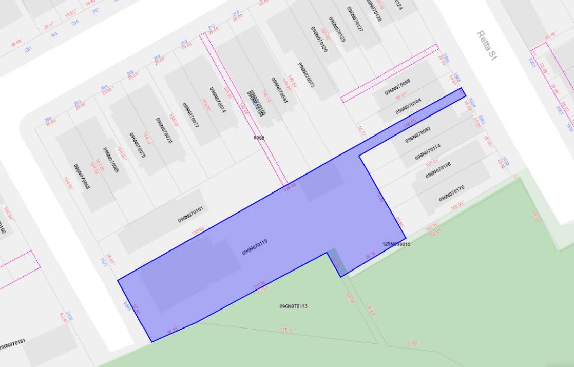
Figure 2: City of Philadelphia Atlas Property Outline of 3565 Freeland Avenuestreet from private property. Upon opening a decorated wrought iron gate, a series of stone steps guides occupants up to the front yard of the property. This small separation between the dwelling and the fence creates breathing space between the retention wall and the front porch.
The home sits on a stone foundation wall. Sitting atop this foundation, a covered porch wraps around the entire length of the north side and half of the east side of the dwelling. This porch has a pitched roof that begins above the first story windows and slopes down towards Freeland Avenue, being capped by a simple unornamented running trim. The porch is a simple work of construction. In the north elevation, the porch is composed of 5 bays, the center bay being slightly less wide than the other bays. Stick-like corner brackets define the 2 sets of side bays. A railing, infilled with simple white balusters, stretches along the 2 sets of side bays.
Covered by the porch, the first story of the north façade is composed of a double door with a transom above. There are two windows to the left of this door, both double hung wooden windows. They are spaced evenly apart from one another and evenly apart from the edge of the door and the edge of the building. To the right of the door, there is an additional double hung wooden window that is centered between the edge of the building and the right side of the door. All windows and the door have arched brick lintels. Within these lintels, a white stone keystone stands out from the red brick.
The second story of the north façade has 4 double hung wooden windows that are spaced directly above the openings below on the first story. Above these windows, the same arched brick lintel pattern as the first story windows is repeated. A bracketed cornice runs continuously above these lintels. Along the left edge of the last window on the left, the rounded corner turret directly connects itself to this edge of the window. The turret itself has three narrow, double hung windows that are spaced evenly along the curve of the corner turret. The turret is ornamented with teal painted fishscale siding finish and the header of the windows is a continuous simple running trim.
The third story of the Harmer House is a lofted space that is built within the mansard roof. This occupiable space is defined by two gable roof dormers, spaced evenly within the mansard roof. Each dormer has a short double hung window with a rounded transom above. The dormers are finished with rows of alternating fishscale, mitered corner, and half cove patterned shingles, matching the color and patterns of the corner turret. The mansard roof itself is finished with rows of alternating fishscale and mitered corner asphalt shingles, and topped with a simple, continuous running trim at the peak.
Additional occupiable space within the third story is located in the rounded corner turret. Repeating the pattern of window shape, size, and placement as the windows within the turret on the second story. Three double hung windows are spaced evenly along the curve of the rounded turret. A jagged running trim is placed above these windows, and the overhang of the tower’s roof flares out above that. The peak of the tower is a cone shaped roof, finished with asphalt shingles and topped with a metal finial.
A seemingly separated portion of the Harmer House can be seen in the east elevation of the home. A 3-story gable roof projecting bay creates additional occupiable space within the
home. The porch terminates where this projection begins. This projecting bay is partially angled, creating a tri-sided corner space for the interior. There are 3 double hung windows on the first level and 3 double hung windows directly above on the second level. The third level appears to be an attic space with a small, short, double hung window placed within the gable wall. Additionally, a single-story timber frame addition is attached to the east side of the dwelling. This space is topped with a flat roof and is finished with wood shingles and a 4-bay window that arches out slightly.
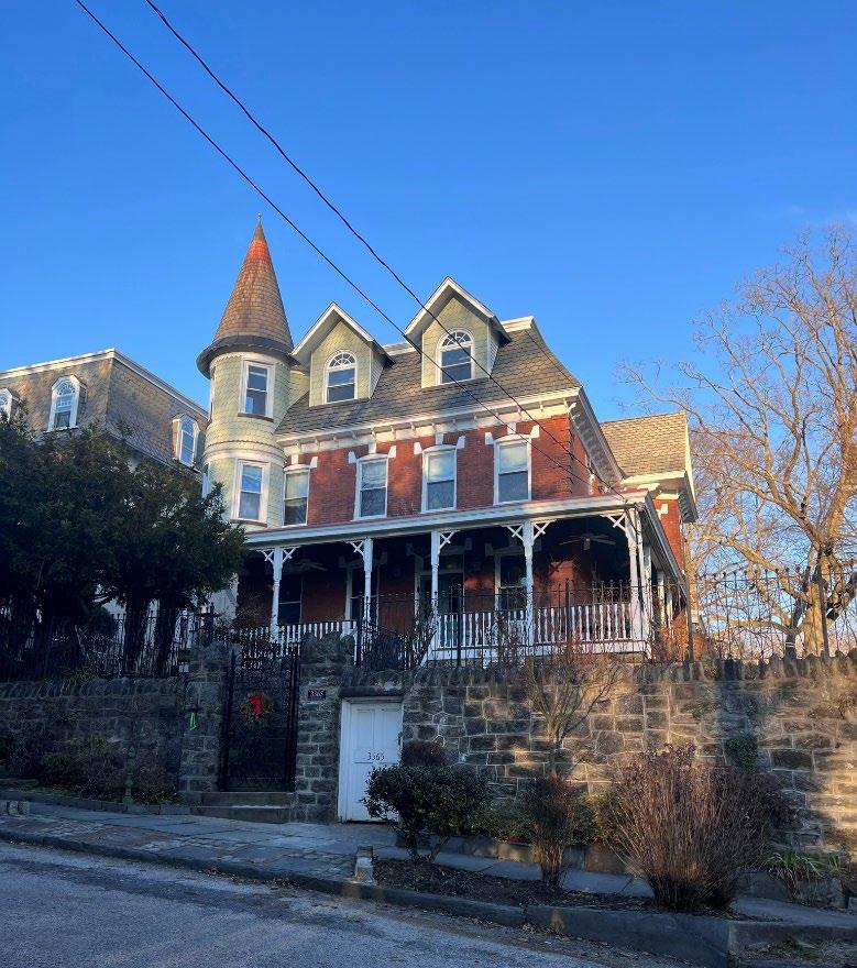 Figure 3: North (Freeland Avenue) elevation
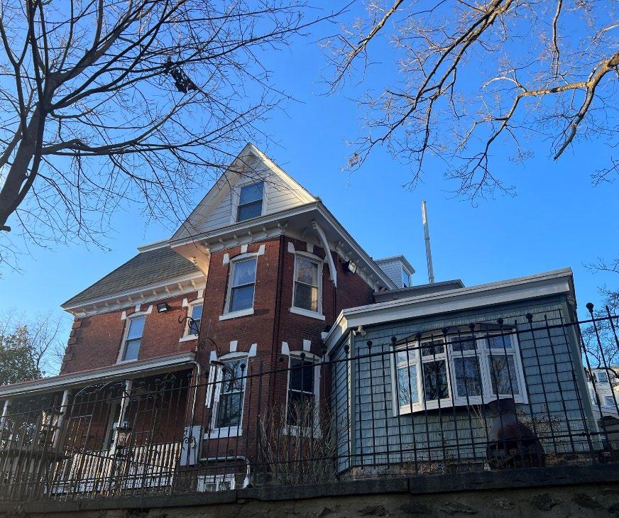
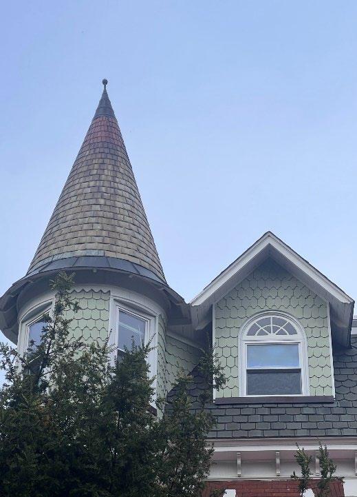
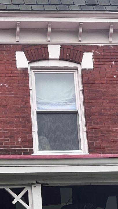
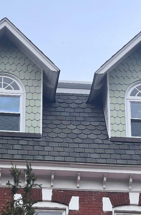 Figure 4: East elevation
Figure 6: North Elevation window detail
Figure 7: North Elevation dormer detail
Figure 5: North Elevation turret and dormer detail
Figure 4: East elevation
Figure 6: North Elevation window detail
Figure 7: North Elevation dormer detail
Figure 5: North Elevation turret and dormer detail
7. Significance
The existing dwelling located on 3565 Freeland Avenue was constructed between 1898 and 1895. 2& 3 The Harmer House was built during the heyday of the Wissahickon neighborhood. The neighborhood was quickly developing its suburban presence during this time. In its early years, the Wissahickon neighborhood could be defined by the houses that occupy the streets, especially along the streets of the neighborhood that borders Fairmount Park. These houses were primarily free-standing homes, twins, and rowhomes. 4 Various examples of the larger freestanding homes within the neighborhood displayed clear characteristics of Queen Anne revival style architecture. Upon construction, and as it stands today, the Harmer House is one of the most prominent homes of this style in the neighborhood.
The owner of the Harmer House was also the constructor of the house. Within this same decade of its construction, Albanus A. Harmer constructed multiple dwellings along Sumac Street, Rochelle Avenue, and Retta Street. 5 The houses that he constructed along these residential streets were later sold to various owners. He became known locally for constructing various row houses and twins, assisting in the development of the architectural language of the Wissahickon neighborhood. The Harmer House was the only known Queen Anne revival style house that he constructed within this neighborhood.
Along with its prominent presence in the neighborhood for its size, style, and builder, the Harmer House stands at the top of a connection point for pedestrians between the Wissahickon neighborhood and the bike trail in Fairmount Park. At water level, the house can be seen sitting atop a large hill 6 . This house can be quickly identified as the Harmer house because of its distinct brick detailing and prominent corner turret. As one approaches the Wissahickon neighborhood from the connection point, also known as the 100 Steps, they can orient themselves to where they are within the context of the park by referencing the Harmer House as a focal point for the entryway to the neighborhood.
Considering that the Harmer House is a pinnacle example of the Queen Anne revival style which is a typical architectural style for the Wissahickon neighborhood; that the Harmer House was constructed by Albanus A. Harmer, a builder who constructed multiple residences within the neighborhood and assisted in the establishment of this suburban district; as well as the prestigious location, atop a large hill with direct access to Fairmount Park, this house satisfies the
2 “The Philadelphia Real Estate Record and Builders’ Guide, vol. 3”, Athenaeum of Philadelphia, September 10, 1888, htp://www.philageohistory.org/rdic-images/view-bookuv.cfm/PhilaBuildersGuide_v3_1888#?c=&m=&s=&cv=565&xywh=-1656%2C641%2C6753%2C2312
3 Ernest Hexamer and Son Co., Insurance Maps of the City of Philadelphia, Volume 26, 1895-1914, Atlas map, Free Library of Philadelphia, Philadelphia
4 Joseph Minardi, City of Neighborhoods: Philadelphia 1890-1910 (Philadelphia: Schiffer ,2020), 140-150.
5 “The Philadelphia Real Estate Record and Builders’ Guide, vol. 1-14”, Athenaeum of Philadelphia, 1886-1889, htp://www.philageohistory.org/BuildersGuide/
6 Frank Berry, 100 Steps, Lower Wissahickon Creek, Manayunk, photograph, Library Company of Philadelphia, 1907, htps://digital.librarycompany.org/islandora/object/Islandora%3A59530
following criteria for historic designation as set forth in the Philadelphia Historic Preservation Ordinance 14-1004(1):
C: Reflects the environment in an era characterized by a distinctive architectural style;
E: Is the work of a designer, architect, landscape architect or designer, or engineer whose work has significantly influenced the historical, architectural, economic, social, or cultural development of the City, Commonwealth, or Nation; and
H: Owing to its unique location or singular physical characteristic, represents an established and familiar visual feature of the neighborhood, community, or city.
Figure 8: 100 Steps, Lower Wissahickon Creek, Manayunk, 1907 ,https://digital.librarycompany.org/islandora/object/Islandora%3A59530Albanus A. Harmer and the Wissahickon Neighborhood
In the mid to late 1800’s and early to mid 1900’s effort to develop the neighborhoods within Northwest Philadelphia, the Wissahickon area quickly became a middle class, upscale suburban neighborhood. 7 The development of this neighborhood occurred because of the industrial revolution and its connection to the surrounding areas within Northwest Philadelphia. Railroads developed along the Schuylkill, the Penncoyd Ironworks built its empire, Manayunk established more mills and businesses, and more Philadelphians realized that they desired to live in an area with more space and ability to directly connect to nature, people migrated towards this area. 8 Additionally, the Wissahickon neighborhood is located at a higher elevation and has a panoramic view of the Wissahickon Creek and Fairmount Park. Due to these series of events and developments, the prime location, and direct connection to the natural landscapes, the Wissahickon neighborhood became a highly desirable place to live.
During this significant era for the Wissahickon neighborhood, a large portion of the land along the southern edge of the boundaries belonged to the Kenworthy brothers, Ben and Joseph Kenworthy. The plot of land that 3565 Freeland Avenue currently occupies was specifically owned by Ben Kenworthy and his wife Sarah Ann. In 1888, a builder of Northwest Philadelphia named Albanus A. Harmer purchased multiple plots of land from the Kenworthy brothers.One of these plots of land being the property of 3565 Freeland Avenue. 9 Shortly after purchasing multiple plots of land, Albanus Harmer began constructing various homes within the plots of land that he purchased from the Kenworthy’s. While building various homes along Sumac Street, Rochelle Avenue (Previously Jannette Avenue), and Retta Street, he began to build his own home in 1889 at 3565 Freeland Avenue. 10
Albanus Harmer completed the construction of a free standing 2 1/2 story Queen Anne Revival style dwelling by 1895. 11 The Queen Anne revival style was a common building style for this neighborhood during its early years of development. The Harmer House became a part of the common description of the style for this neighborhood. Architectural elements such as a prominent rounded corner turret, covered wrap around porch, fishscale siding, mansard roof with protruding dormers, brick pattern details, and ornamental details allow this house to be a prime example of the Queen Anne revival style. Not only does this home possess characteristics that represent an entire architectural style, but it also possesses characteristics that allow the dwelling to be a prime example of what the neighborhood looked like when it was first established as a suburban development.
The period of significance for this property can be identified as 1889-1901. During the first 8 years of its life, the Harmer House was passed through multiple hands. This is mainly because of the seizure of the property that occurred in 1900 due to the accumulation of a large
7 Minardi, City of Neighborhoods: Philadelphia, 140-150.
8 Abigail Perkins, “Northwest Philadelphia” Encyclopedia of Greater Philadelphia, Rutgers University (2013), htps://philadelphiaencyclopedia.org/loca�ons/northwest-philadelphia/
9 Athenaeum of Philadelphia, “Builders’ Guide, vol. 3”.
10 Athenaeum of Philadelphia, “Builders’ Guide, vol. 4”.
11 Ernest Hexamer & Son, Insurance Maps of the City of Philadelphia, vol. 26 (1895)
monetary debt to the state. 12 Once the Harmer House was purchased out of state/estate control in 1901, the property became family owned. 13 Ever since this transaction in 1901, the house has been passed down multiple times through generational inheritances. The Harmer House has been a treasure for families throughout the decades of its occupancy, and as a result it has been well maintained. The house itself has remained in a condition that preserves the overall integrity of the original construction. All of the primary architectural elements are still present, the original brick details are still intact, and the property has remained the same size since its original creation. 14
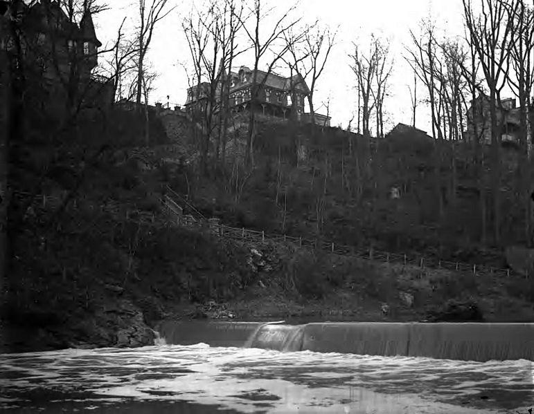
In addition to its architectural significance, this building has also proven to be an anchor point in the neighborhood due to its direct adjacency to an access point to Fairmount Park and the Wissahickon Creek bike trail. The entry point to the park, commonly referred to as the 100 Steps, is located at the southern end of Freeland Avenue. The nearest building to this public park access point is the Harmer House. Sitting approximately 7 feet above street level, the house can be seen from the lower elevation at the water level of Wissahickon Creek.8 The Harmer House, from this view, becomes a focal point for the neighborhood and can be identified as the start of the south side of the Wissahickon neighborhood from afar.
12 Philadelphia City Archives, Philadelphia County Sheriff’s Deed Book, vol. 199 (1900): 208
13 Philadelphia City Archives, Deed JVA, vol. 205 (1901): 361
Frank Berry,
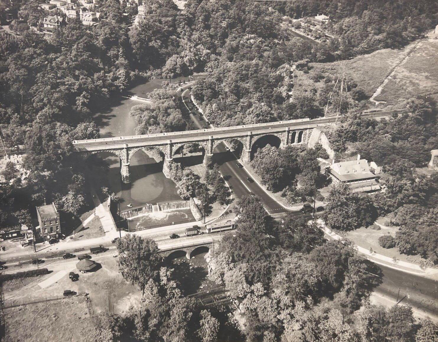
14 “100 Steps, Lower Wissahickon Creek”. Figure 9: Aerial View of Wissahickon Creek Section of Fairmount Park, 1931. The Harmer House can be seen in the top left corner of the image.8. Major Bibliographical References
Athenaeum of Philadelphia. “Philadelphia Real Estate Record and Builders’ Guide, vol. 3.”
September 10, 1888. http://www.philageohistory.org/rdic-images/view-bookuv.cfm/PhilaBuildersGuide_v3_1888#?c=&m=&s=&cv=565&xywh=1656%2C641%2C6753%2C2312
Berry, Frank. 100 Steps, Lower Wissahickon Creek, Manayunk. Photograph. The Library Company of Philadelphia, Print Department, Berry Collection. 1907.
https://digital.librarycompany.org/islandora/object/Islandora%3A59530
City of Philadelphia Atlas. 3565 Freeland Avenue, 2023.
https://atlas.phila.gov/3565%20FREELAND%20AVE/property
City of Philadelphia Department of Records. City Archives. Sheriff’s Deeds, CP b. 4, p. 208-212. 6/7/1900.
City of Philadelphia Department of Records. City Archives. JVA b. 205, p. 361-363. 5/16/1901.
City of Philadelphia. PhilaDox EWeb. Doc. 53071436. 6/12/2016.
Ernest Hexamer & Son Co. Insurance Maps of the City of Philadelphia, Volume 26. 1895-1914. Atlas map. Free Library of Philadelphia, Philadelphia.
Google My Maps. Maxar Technologies. 3565 Freeland Avenue, 2023.
https://www.google.com/maps/d/u/0/edit?mid=1DBmcwpAaP6FBTxokVOUdkrSQ8tGqvH8&ll=40.01727599992371%2C-75.2054601861298&z=20
Minardi, Joseph. City of Neighborhoods: Philadelphia 1890-1910. Philadelphia: Schiffer, 2020.
Perkins, Abigail. “Northwest Philadelphia.” Encyclopedia of Greater Philadelphia. Rutgers University Press. 2013. https://philadelphiaencyclopedia.org/locations/northwestphiladelphia/
The Philadelphia Free Library. Wissahickon Creek Section of Fairmount Park with the New Henry Avenue Bridge in the Foreground, Photograph. Photography Collection no. 14393. 6/13/1931.