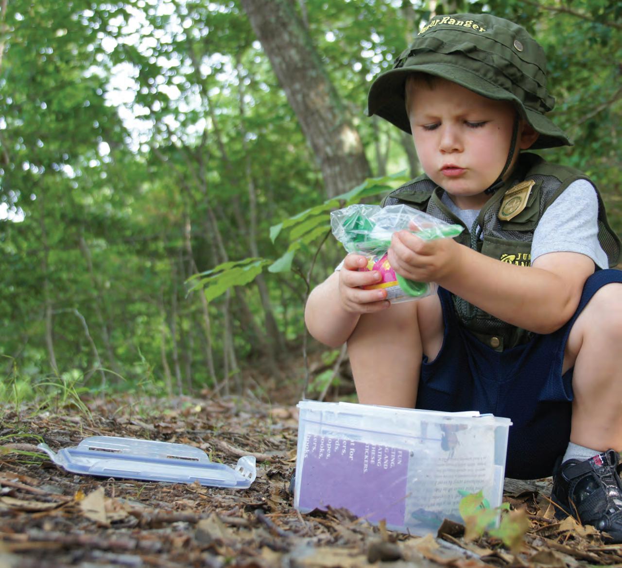
Geocaching is fun for all ages to explore the Chesapeake.
PHOTO BY KATHERINE TRACEY, NPS
Mission
The Chesapeake Conservancy’s mission is to strengthen the connection between people and the watershed; conserve the landscapes and special places that sustain the Chesapeake’s unique natural and cultural resources; and restore landscapes, rivers, and habitats in the Chesapeake Bay region.
Board of Directors
Douglas P. Wheeler, Chair
Anne W. Scott, Vice Chair
Robert Gensler, Treasurer
Robert G. Stanton, Secretary
Marc Bunting
Jane Danowitz
Leslie Delagran
Joel E. Dunn
Holly A. Evans
Robert E. Friend
Heather Gartman
Stephen F. Harper
Verna Harrison
Barbara Jackson
Randall W. Larrimore
Turney McKnight
Jeffery More
John G. Neely
Dr. Mamie A. Parker
Richard Scobey
Honorary Members
Gilbert M. Grosvenor
U.S. Senator Paul Sarbanes (ret.)
U.S. Senator John Warner (ret.)
Emeritus Directors
Patrick F. Noonan
Charles A. Stek
Chesapeake Conservancy Staff
Joel E. Dunn, President & CEO
Jeffrey Allenby, Director of Conservation Technology
Carolyn Black, Interpretation and Partnership Associate
John Griffin, Program Manager, Chesapeake Conservation Partnership
Louis Keddell, Senior Geospatial Analyst Jacob Leizear, GIS Fellow
Joseph McCauley, Chesapeake Fellow
Emily Mills, Geospatial Analyst
Michael Norton, Research Manager
Cassandra Pallai, Geospatial Program Manager
David Saavedra, Senior Geospatial Analyst
Jared Schultz, Grants Specialist
Susan Shingledecker, Vice President & Director of Programs
Helen Sieracki, Development Coordinator
Rachel Soobitsky, Geospatial Analyst
Robin Talbot, Executive Assistant
Colleen Whitlock, Director of Administration
United Outside: Conservation and Economy
For the first time, the federal government has included the effects of outdoor recreation as part of its annual assessment of the national economy, and the results are staggering. Outdoor recreation comprises 2 percent ($373.7 billion) of the 2016 U.S. Gross Domestic Product. According to Outside Magazine, this is comparable to industries like construction (4.3 percent) and legal services (1.3 percent). On the heels of this study came new data from the Outdoor Industry Association, which broke down similar information by congressional districts. This data shows that residents in the Chesapeake Bay watershed spend more than $52 billion annually on outdoor recreation, and 700 outdoor recreation companies in the region employ 1 million people.
Why is this significant? It’s proof of what we’ve been saying all along—conservation and a healthy economy go hand-in-hand. They each thrive together. Protecting the Chesapeake’s special places supports our communities, culture, and economy and is also important to maintaining the ecological health of the Chesapeake Bay and its watershed.
In Maryland, Governor Larry Hogan has taken note. According to the Outdoor Industry Association, the outdoor economy equates to $14.0 billion in consumer spending, 109,000 direct Maryland jobs, $4.4 billion in wages and salaries, and $951 million in state and local tax revenue.
Governor Hogan recently signed an executive order establishing the Maryland Outdoor Recreation Economic Commission, which is charged with developing innovative strategies to market Maryland’s unique outdoor and heritage recreation brand, as well as recommend initiatives to grow and attract new companies. Additionally, the commission will explore ways to retain and support Maryland’s existing outdoor recreation businesses.
Anyone who has tried to get into a Chesapeake waterfront park on a weekend, such as Sandy Point State Park in Annapolis, for example, can agree: we need more public places to recreate and appreciate the beauty of the Chesapeake Bay. At Sandy Point long lines to enter create a traffic problem, and officials often have to turn people away during the peak season. This is not acceptable, and it underscores the Conservancy’s fight to protect state and federal conservation programs, including Program Open Space
in Maryland, the Keystone Fund in Pennsylvania, the Open Space Program in Delaware, and the federal Land and Water Conservation Fund.
Here in Maryland, we were thrilled that the state’s General Assembly approved Governor Hogan’s request to fully fund Program Open Space ($183 million) and the Chesapeake and Atlantic Coastal Bays Trust Fund ($50 million). Our organization has worked towards this outcome for many years. At the federal level another significant milestone was achieved in March when Congress approved $73 million for Chesapeake Bay restoration, $6 million for land conservation, and $2 million for public access.
By protecting and restoring the Chesapeake, we are enhancing the economy and opportunities for the public to get outdoors and enjoy the magic of this beautiful estuary.
Sincerely,
Joel e. Dunn, President and CEO
Chesapeake Conservancy President & CEO Joel Dunn
PHOTO BY MARK HAMILTON
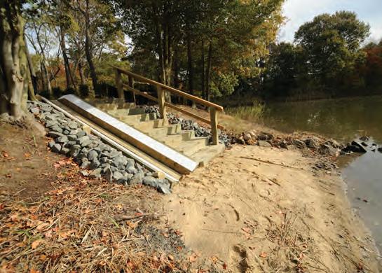
Paddlers Gain New Access at Scenic Wye Island, MD
A new public access site on Wye Island in Queen Anne’s County, Maryland, opens the scenic island to new recreational opportunities. With support from REI Co-op, whose generous funding matched a grant from the Maryland State Highway Administration’s National Recreational Trails Program, Chesapeake Conservancy successfully completed the installation of a new canoe and kayak launch.
The new launch provides access to the Captain John Smith Chesapeake National Historic Trail within a 1.5-hour drive from the metro DC-Annapolis-Baltimore corridor, making it an ideal location for urban day-trippers, as well as those on longer excursions.
Once nearly lost to a housing development, Wye Island was purchased by the state with Program Open Space funds and turned into a natural resources management area. Maryland’s Department of Natural Resources manages the island to protect diverse habitats, provide for recreation, and stabilize some 30 miles of shoreline.
An incredible place to explore by land and by water, Wye Island provides habitat for the Delmarva fox squirrel, which until recently was on the Endangered Species List. A diversity of birds also visit the island, including warblers, bluebirds, vireos, and wintering wildfowl. More than 12 miles of hiking trails offer opportunities for hikers of any level.
“This feels like a personal victory to me,” President and CEO Joel Dunn said. “Years ago, my wife and I tried to kayak from public property at Wye Island, and we were told to leave. I vowed to find a way to create public access so that everyone could explore this beautiful place by water. Thank you to REI, the Maryland State Highway Administration, and the Maryland Department of Natural Resources.”
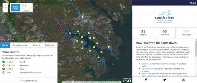
New Technology Helps Public Answer: How Healthy Is the South River?
The South River Federation based in Edgewater, Maryland, a nonprofit organization to protect, preserve, restore, and celebrate the South River, recently launched a new online water quality map built in partnership with Chesapeake Conservancy.
The interactive South River Data Map helps visualize data from water quality samples collected by Federation staff and volunteers. Analysis of bacteria levels, dissolved oxygen, and water clarity helps answer:
1. Is it safe to swim?
2. Can fish breathe?
3. How dirty is the water?
“Over the last 15 years of stewardship, we have amassed a great deal of data and information about the health of the South River,” Federation Executive Director Elizabeth Buxton said. “We turned to Chesapeake Conservancy for the technical expertise to help visualize this information for the public. Together, we built a one-stop shop for anyone wondering if it’s safe to swim or where our current restoration projects are taking place.”
“We create technology solutions to help organizations like South River Federation spend less time on technology and more time on conservation,” says Joel Dunn, Chesapeake Conservancy president and CEO. “Information is power, but only if it is presented in a way that people can use. With this tool, the South River Federation can empower the public with the most up-to-date information about the health of the river.”
“With more centralized and consolidated data, South River Federation now has the ability to quickly mine their data for new insights to prioritize and guide their work moving forward,” added Chesapeake Conservancy Director of Conservation Technology Jeffrey Allenby. “This is a project that can be replicated for other rivers of the Chesapeake.” View the map at www.southriverdata.net
A new launch at Wye Island for paddlecraft provides access to the Chesapeake Trail.
PHOTO BY PETER TURCIK
New Chesapeake “Treasure Hunt” Launches June 9
By Cindy Chance
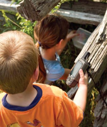
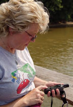
The National Park Service and Chesapeake Conservancy are preparing a new way for adventurers to discover Chesapeake places. Volunteer geocachers with the Maryland Geocaching Society and NoVaGo are working with park managers at more than 60 locations on eight Chesapeake rivers in Maryland, Pennsylvania, and Virginia to create a sophisticated version of hide-and-seek. Geocaching, pronounced “geo-cashing,” is a worldwide phenomenon, in which participants use a hand-held GPS (Global Positioning System), or smartphone, to plot map coordinates to locate a hidden treasure or “cache.” Searching for a cache is akin to going on a treasure hunt and can involve visits to multiple locations within a park to collect clues and solve riddles. Shovels are forbidden—caches are never buried. Containers are typically watertight with lids that snap locked and are clearly identified with an “official geocache” sticker.
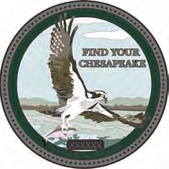
The “Find Your Chesapeake GeoTrail” will be the third such collaboration, building on the success of geotrails along the Star-Spangled Banner and the Captain John Smith Chesapeake national historic trails. A “geotrail” is a series of caches tied together by a common topic or theme. In this case, the sites are featured on www.FindYourChesapeake.com and engage visitors with interpretive and educational programming showcasing the history and natural environment of our national treasure, the Chesapeake Bay.
Launch Event June 9
The Find Your Chesapeake (FYC) GeoTrail will launch June 9 at the Zimmerman Center for Heritage in Wrightsville, Pennsylvania, a visitor contact station for the Captain John Smith Chesapeake National Historic Trail (NHT). Geocaching volunteers will be on hand at the kick-off event to teach the basics to people new to the hunt, and extra caches will be placed, including some just for kids. The event runs 10:00a.m. until noon. Expect most serious geocachers to bolt as soon as the FYC Geo Trail cache coordinates are officially “published” sometime around 11:30, and cachers download the coordinates to their mobile devices. Each cache container holds a special bonus prize of a “First to Find” pin, and every serious geocacher wants one of those!
A collectible, highly coveted, trackable geocoin will be awarded to the first 300 geocachers who locate at least 20 FYC caches. To earn the coin, geocachers must download a passport from the Find Your Chesapeake website, find at least 20 geocaches, record the secret code word in the passport, and log their finds on www.geocaching.com. After discovering the 20 required caches, geocachers may have their passports validated via mail at the National Park Service Chesapeake Bay Office, and—for the lucky 300—a beautiful two-inch metal coin will be returned in the mail. The geocoins are engraved with a trackable number that geocachers use to “follow” the coin or “discover” a coin held by others.
Some people can find 20 geocaches in a fun-packed busy weekend, but others may take months to get to that many locations. The FYC GeoTrail is designed to introduce people to a wider Chesapeake experience, since no one river contains enough geocaches to earn the coin. There are 8 geocache locations on the James River, 6 on the Rappahannock, 10 on the Susquehanna, 7 on the Nanticoke, 7 on the Patuxent, 11
on the Potomac, 3 on the Patapsco, and 10 on the Upper Eastern Shore. Many of these locations will introduce people to places along the Captain John Smith Chesapeake NHT as well.
How It Works
To join the adventure, a geocacher must access the official geocache website at www.geocaching.com to set up an account. A basic membership is free. Once an account is established, the geocacher can use the advanced search function to locate the Find Your Chesapeake account, retrieve the map coordinates, and see the cache details for each Find Your Chesapeake geocache. Included with the information for each cache location is a description of the site and its significance to the Chesapeake Bay watershed. The next step is to head outside with a GPS device!
Who goes geocaching? All kinds of people—young groups of friends, experienced geocachers, and families. The combination of digital technology, puzzles, the outdoors, and geocache containers with “prizes” inside is appealing to all ages—especially children. A geocache container holds a logbook for signing and also a motley collection of toys and trackable items that geocachers leave for each other. The rule is that you can take an item from the container so long as you leave a replacement item of equal or greater value.
When geocachers log their find on their online accounts, they often leave fun comments about their experiences,
Geocaching requires a GPS device or smart phone to plot map coordinates for hidden caches.
PHOTO BY MATT RATH, NPS
Young people especially enjoy the hunt and the thrill of discovery.
PHOTO BY MATT RATH, NPS
Images of the geocoin for the first 300 geocachers who submit their completed passports to the National Park Service Chesapeake Bay Office. IMAGES COURTESY OF NPS
such as: “Thanks for the history lesson and fun! I have lived in the area most of my life and never been here. Today was the day, and it is simply amazingly beautiful.” “Great cache! Never would have known about this place otherwise!”
There are over 3 million active geocaches worldwide, hidden in 191 different countries on all seven continents. Yes, there is probably one very close to you right now. To know more, go to www.geocaching.com Watch a short video about how the adventure works here: https://youtu.be/vuFiLhhCNww Check www.FindYourChesapeake.com to download the new geotrail’s passport and check the events calendar for the trail’s kick-off on June 9.
Cindy Chance is a cultural anthropologist with the National Park Service Chesapeake Bay Office and has coordinated the office’s three geotrails.
SAVE THE DATE NOVEMBER 1, 2018 6:00 p.m.
Carnegie Institution for Science Washington, DC
Mapping Analysis Aids Conservation Goals
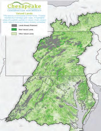
The Chesapeake Conservation Partnership—a coalition of diverse organizations and agencies engaged in land conservation and related fields within the Chesapeake Bay watershed—has been working for two years on a series of conservation mapping analyses to create the Chesapeake Conservation Atlas. Building upon work done in 2016 to develop a series of long-term conservation goals for farms, forests, habitat, heritage, and human health, the maps look at existing resources and possible influences on the ability to achieve long-term conservation goals.
Based on these analyses, the Chesapeake Conservation Partnership identified 11.5 million acres of highly valued lands for conservation, meaning lands that hold a high overlap of farms, forests, habitat, or heritage lands. In addition, they have identified 22 million acres of important forest, 19 million acres of important wildlife habitat, 20 million acres of land that can support farming, and 24 million acres of land that represents cultural and natural heritage. Each of these core values—farms, forests, habitat, and heritage—equates to approximately half the watershed. While there are many potential influencing factors, the partnership chose initially to map and analyze six key factors: energy infrastructure, inundation, projected development, farmland preservation capacity, land trust capacity, and existing conservation focal areas. These, in conjunction with the composite of the original long-term conservation goals maps (as seen to the right) work to define where landscape level conservation should be prioritized in the future.
To learn more about the Chesapeake Conservation Partnership’s work, visit chesapeakeconservation.org.
Partners Advance Protection along the Nanticoke
In partnership with the Mt. Cuba Center, Chesapeake Conservancy is making significant strides on the Nanticoke River Conservation Corridor to connect existing conserved lands and protect the ecological value of the watershed. As of March 30, the Conservancy has contributed to the permanent protection of 12 properties totaling 1,702 acres within the corridor and is working toward the protection of an additional 998 acres. This work also supports the U.S. Navy’s efforts to protect land within airspace used for research and testing of mission-critical aircraft. The Conservancy continues to push for federal funding from the Land and Water Conservation Fund. Congress included $1M in the Fiscal Year 2018 federal budget for land conservation at the Blackwater National Wildlife Refuge complex on Maryland’s Eastern Shore—a welcomed outcome for the Conservancy, Blackwater, the U.S. Navy, and the many other partners working to protect land in the Middle Chesapeake Sentinel Landscape, which includes Blackwater NWR and the Nanticoke River.
The U.S. Navy works with conservation partners to protect the Middle Chesapeake Sentinel Landscape, an area where this F-35 Lightning II Joint Strike Fighter and other aircraft are tested. PHOTO COURTESY OF LOCKHEED MARTIN
Birds, Birds, Birds! Wildlife Webcams Welcome Spring
As spring arrived, Conservancy staff saw this news via email:
Busy, busy, busy morning!
1. Osprey: We now have two ospreys on the platform! The first arrived yesterday, and another this morning.
2. Falcons: First egg! 6:55 a.m. today
3. Heron: Many, many heron in the rookery!
The next day’s report: Second egg in downtown Baltimore! 4:56 p.m. 3/21. The stories Barb will tell, laying an egg in snow on the second day of spring!
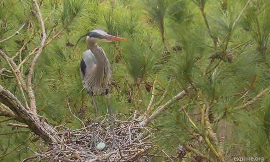
Excitement is palpable as Chesapeake Conservancy’s wildlife webcams herald spring’s return with live action at the nests that have captivated wildlife watchers worldwide in recent years.
Our partners at Explore.org installed new sophisticated cameras at the great blue heron rookery and the osprey platform. There are three nests prominently in view at the heron rookery on Maryland’s Eastern Shore. This promises to be an exciting season watching these large birds raise their families in their relatively small nests!
At the peregrine falcon cam in downtown Baltimore, home to “Boh and Barb,” four eggs are on the window ledge of the 33rd floor of the Transamerica building.
The Crazy Osprey Family near Annapolis reported that “Tom and Audrey” returned on March 18 and 19, close to the Chesapeake’s lore of their traditional return on St. Patrick’s Day.
Share the excitement. Tune in to watch some of the Chesapeake’s most iconic species “up close and personal” at www.chesapeakeconservancy.org.
How AI for Earth Can Be a Force Multiplier for Sustainability Solutions
Microsoft Corporation recently published a piece about their work with Chesapeake Conservancy’s Conservation Innovation Center.
The 21st century is the age of data and artificial intelligence (AI), two powerful tools with the potential to solve some of the world’s most pressing problems. Yet many researchers and leaders are still trying to take on today’s challenges using tools from the past—especially when it comes to protecting the environment.
Take, for instance, the iconic Chesapeake Bay. Its watershed stretches from New York south to Virginia in the United States, spanning more than 64,000 square miles and supporting more than 3,600 species of plants and animals. Despite its importance, the Bay’s health over decades has been marred by sewage overflows and runoff of animal waste and chemicals. The future of the watershed, home to more than 17 million people, depends upon smart conservation that is informed by data about where growth is least harmful and where interventions can be most helpful.
That requires a detailed, precise, current map of the region. Until recently, that simply didn’t exist because collecting so much data and converting it
into usable land-cover maps was an onerous, expensive, and tediously slow process. But now the Chesapeake Conservancy, a small nonprofit dedicated to protecting and restoring the lands and waters of the Chesapeake Bay, has used the 21st-century power of cloud computing to create a new, up-to-date map.
The precision mapping is a kind of “MRI on the landscape,” says Joel Dunn, Chesapeake Conservancy president and CEO. It allows for a kind of precision conservation that was previously impossible—and it’s a strategy that could be used to help protect other imperiled waterways around the globe, if individuals and organizations can access the technology that made this possible and use it to its fullest potential.
Working with Microsoft allows Chesapeake Conservancy to build on its innovative map project and begin to scale. The Conservancy is now working with Microsoft and Esri, a mapping and geographic information system leader, to apply a deep-learning approach to create an algorithm for updating the existing precision data and to make it available to other partners across the U.S. to create similarly detailed maps.
A screenshot from the great blue heron cam shows the season’s first egg, March 2018 PHOTO BY CHESAPEAKE CONSERVANCY WEBCAMS
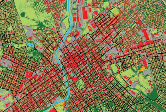
A close-up of York, Pennsylvania, shows a view of the watershed land cover. Shades of green on the map represent shrubs, wetlands, and tree canopies, while red depicts structures, and black lines mark impervious roads. BY THE CHESAPEAKE
Donor Spotlight: Ed Haile & Connie Lapallo
When it was time to study Captain John Smith’s explorations of the Chesapeake— the basis for what would become the Captain John Smith Chesapeake National Historic Trail—one of the experts called upon was Ed Haile. A donor and long-time supporter of Chesapeake Conservancy, Edward Wright Haile is a historian, poet, and the editor of Jamestown Narratives and author of John Smith in the Chesapeake, as well as two Bay-history maps.
His expertise on Smith’s travels was pivotal to the trail’s establishment. After a year of feasibility studies undertaken by the National Park Service, the trail was authorized by the U.S. Congress and signed into law by President George W. Bush in 2006.
Conservancy Board & Staff News
The Board of Directors recently elected new members: Marc Bunting, Leslie Delagran, Randall Larrimore, and Dr. Mamie Parker, who returns to the board after serving from 2009 to 2015. Paul E. Hagen, and Nicholas H. Dilks finished their terms. Michael Hankin and Edward T. McMahon have left the board to focus on other commitments.
Douglas P. Wheeler was elected to serve a second term as chair; Anne W. Scott will serve as vice chair; Robert Gensler will serve a second term as treasurer; and Robert G. Stanton will serve as secretary. Thank you to all of our board members, past and present, for your support!
“We wouldn’t be here today without Ed’s knowledge and support. His help with the mapping was absolutely instrumental in the trail’s establishment,” Chesapeake Conservancy Board Member Turney McKnight said.
Captain John Smith’s journal tells us that “markes” represent actual crosses— either of brass or as a shape carved in tree bark—left by the English explorers. Some 400 years later, Haile studied Smith’s journal and worked with longtime Conservancy board member Charlie Stek to put together a plan to place stone markers as near as possible to the original cross locations. Three were eliminated as mapped outside of Smith’s actual area of exploration, leaving a total of 24 in the marker project.
With funding from the Sumner T. McKnight Foundation, the marker project began to take shape. Haile turned to fellow historian Connie Lapallo for help. Lapallo is the author of a trilogy based on the true story of Jamestown’s first women and children: Dark Enough to See the Stars in a Jamestown Sky (1592–1611), When the Moon Has No More Silver (1610–1620), and The Sun Is But a Morning Star (1621–1652). Together with administrative and outreach support from Chesapeake Conservancy’s Director of Communications Jody Couser, the team has placed 17 of the 24 cross markers.
Dr. Mamie Parker received the prestigious William K. Reilly Award for Environmental Governance and Leadership from the Center for Environmental Policy, School of Public Affairs, at American University.
Susan Shingledecker has joined the Conservancy team as vice president and director of programs, coming from BoatU.S. Foundation, where she served as vice president. Previously, she was with
“Chesapeake Conservancy plays a major role in sharing the history of Captain John Smith and the indigenous people he met here in the Chesapeake,” Haile said. “It is my honor to support the good work of the organization. It is important that our Chesapeake history be known.”
“The moment Ed asked for my help, I was hooked on the cross marker project,” Lapallo said. “I wonder who will look down at the markers in 50 or 100 years and think about those who came before them.”
Chesapeake Conservancy is truly grateful to Haile and Lapallo for their support— both in time and donations.
the Maryland Energy Administration and the National Governors Association. Susan manages our partnership with the National Park Service, oversees all programs, and works closely with our president and board of directors.
The Conservancy’s Conservation Innovation Center recently won an award of almost $11,000 in a data visualization challenge sponsored by the U.S. Bureau of Reclamation.
In March, Development Coordinator Helen Sieracki celebrated her fifth anniversary with Chesapeake Conservancy. Helen is a hard worker, always with a smile, and is our resident grammar expert. Thank you, Helen!
We bid a very fond farewell and our heartfelt thanks to several dedicated employees, including Sarah Elder, Chigo Ibeh, Megan McSwain, Colin Stief, and Peter Turcik. We wish them well on their next adventures!
Ed Haile COURTESY PHOTO
Dr. Mamie Parker and Board Chair Doug Wheeler PHOTO COURTESY OF AMERICAN UNIVERSITY
Connie Lapallo COURTESY PHOTO
716 Giddings Avenue, Suite 42 | Annapolis, Maryland 21401
Let’s Keep in Touch!
443.321.3610
info@chesapeakeconservancy.org
www.chesapeakeconservancy.org
www.facebook.com/chesapeakeconservancy
www.twitter.com/chesconserv
www.instagram.com/chesapeakeconservancy/
www.FindYourChesapeake.com
CHESAPEAKE CONSERVANCY RELIES ON OUR MANY FRIENDS TO PROTECT AND CONSERVE THE CHESAPEAKE’S GREAT RIVERS AND SPECIAL PLACES. YOUR TAX-DEDUCTIBLE CONTRIBUTION OF ANY AMOUNT IS TRULY APPRECIATED. OUR TAX ID NUMBER IS #26-2271377.
LEAVE A LEGACY OF THE CHESAPEAKE FOR FUTURE GENERATIONS
Please consider making a special gift to Chesapeake Conservancy by naming the organization in your will or by designating Chesapeake Conservancy as a beneficiary of your bank account, 401(k) or other retirement account, or life insurance policy.
You can help immediately by joining the Chesapeake Stewards Club and providing monthly support for Chesapeake Conservancy’s ongoing habitat and land conservation programs. For more information, call 443.321.3610.