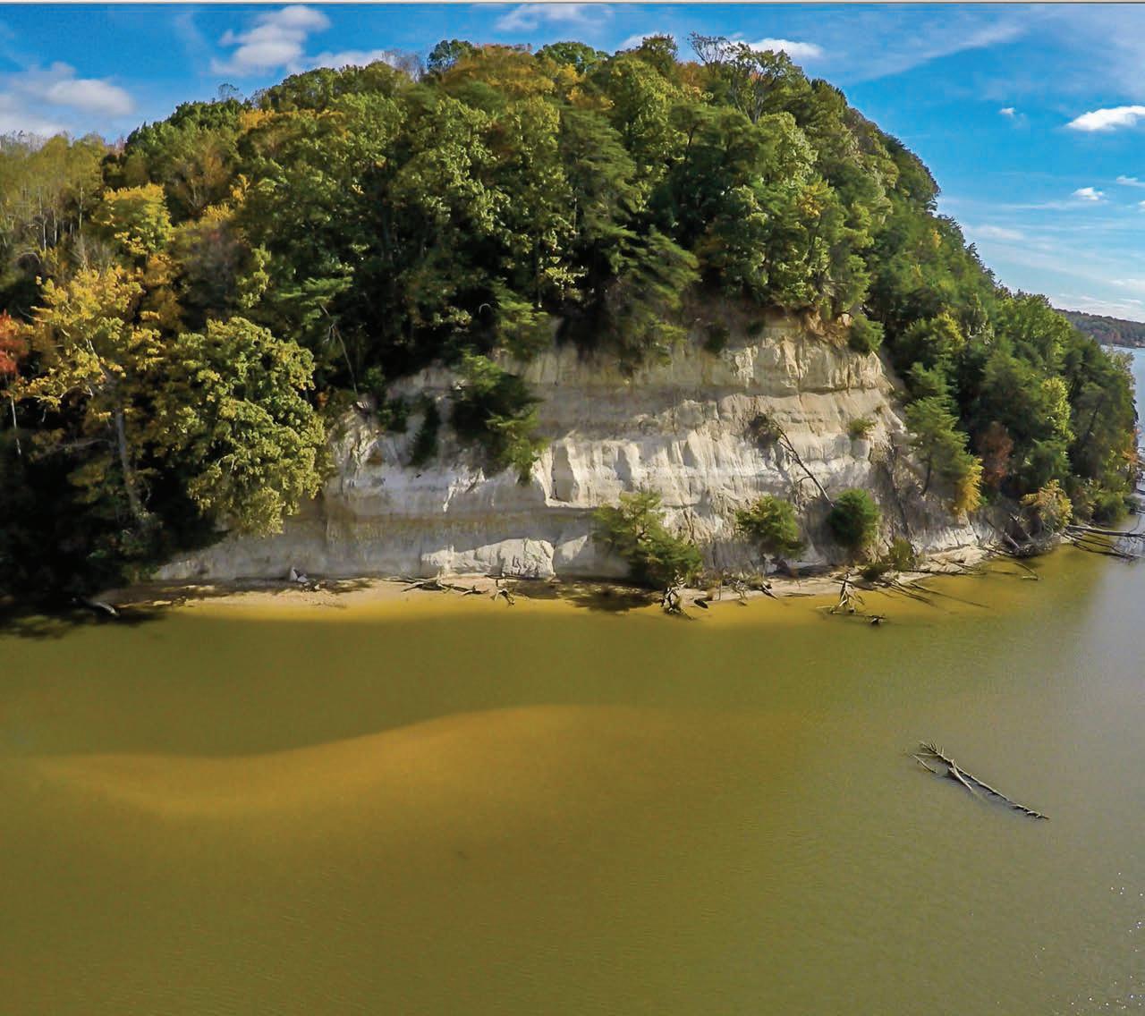
Chesapeake Conservancy and its partners are still working toward a conservation outcome for Fones Cliffs in Virginia.
PHOTO BY JEFFREY ALLENBY
Mission
The Chesapeake Conservancy’s mission is to conserve and restore the natural and cultural resources of the Chesapeake Bay watershed for the enjoyment, education, and inspiration of this and future generations.We serve as a catalyst for change, advancing strong public and private partnerships, developing and using new technology, and empowering environmental stewardship.
Board of Directors
Douglas P. Wheeler, Chair
Anne W. Scott, Vice Chair
Robert Gensler, Treasurer
Robert G. Stanton, Secretary
Marc Bunting
Jane Danowitz
Leslie Delagran
Joel E. Dunn
Holly A. Evans
Robert E. Friend
Heather Gartman
Stephen F. Harper
Verna Harrison
Barbara Jackson
Randall W. Larrimore
Turney McKnight
Jeffery More
John G. Neely
Dr. Mamie A. Parker
Richard Scobey
Molly Joseph Ward
Honorary Members
Gilbert M. Grosvenor
U.S. Senator Paul Sarbanes (ret.)
U.S. Senator John Warner (ret.)
Emeritus Directors
Patrick F. Noonan
Charles A. Stek
Chesapeake Conservancy Staff
Joel E. Dunn, President & CEO
Patty Allen, Office Manager
Jeffrey Allenby, Director of Conservation Technology
Carolyn Black, Interpretation and Partnership Associate
John Griffin, Program Manager, Chesapeake Conservation Partnership
Louis Keddell, Senior Geospatial Analyst LeeAnn King, Geospatial Program Manager
Jacob Leizear, GIS Fellow
Joseph McCauley, Chesapeake Fellow
Emily Mills, Geospatial Analyst
Michael Norton, Research Manager
David Saavedra, Senior Geospatial Analyst
Jared Schultz, Grants Specialist
Susan Shingledecker, Vice President & Director of Programs
Helen Sieracki, Development Coordinator
Patrick Smith, Communications and Partnership Coordinator
Rachel Soobitsky, Geospatial Project Manager
Katie Walker, Geospatial Analyst
Emily Wiggans, Geospatial Analyst
From the President & CEO
The Power of Partnerships
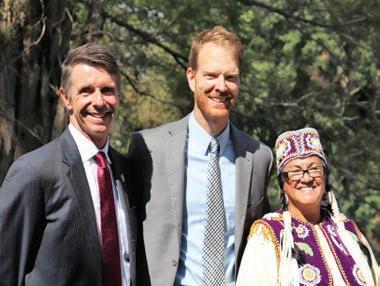
There is a clear link between indigenous peoples throughout the Chesapeake and the movement to protect and restore our collective health, culture, and the ecosystem. Many of us have a respect for the heritage of environmental stewardship among indigenous people. I am proud to say that our organization has been working very closely with the American Indian community in the Chesapeake for more than a decade to advance our mutual cultural and environmental conservation priorities. Recently, I had the honor of attending a ceremony at Werowocomoco on the York River, hosted by U.S. Secretary of the Interior Ryan Zinke in honor of federal recognition for seven American Indian tribes in Virginia. It was a momentous event in the history of the Chesapeake and a globally important moment for civil rights. It was a privilege to be there and hear the songs, stories, and history of Virginia Indian culture. It was a joy to feel the drumbeat of pride, progress, and the tribes’ triumph in my chest.
The seven tribal chiefs, Secretary Zinke, Acting National Park Service Director Dan Smith, U.S. Representative Rob Wittman, and the other participants were eloquent and appreciative. Chief Anne Richardson’s (Rappahannock Tribe) prayer was powerful and memorable. It was an honor to congratulate our founding board member Chief Stephen Adkins (Chickahominy Tribe). It was particularly special to see it all happen at Werowocomoco, the historic epicenter of Virginia Indian governance for hundreds of years, and now permanently protected by the National Park Service with support from partners such as The Conservation Fund and Chesapeake Conservancy.
We have been working in partnership with the National Park Service’s Chesapeake Bay Office and our many other partners for more than a decade to protect special places like Werowocomoco, enhance public access to the Chesapeake and its tributaries, and inspire current and future generations to join us in the pursuit of our shared mission to conserve and restore the natural and cultural resources of the Chesapeake watershed. Note that our organization recently updated our mission statement to more closely complement that of the National Park Service.
The value of partnership is noted in a few other recent achievements. We are proud to join forces with the Chesapeake Bay Foundation and other partners on the “The Keystone 10 Million Trees Partnership,” a monumental collaborative effort to plant 10 million trees in Pennsylvania by the end of 2025.
We recently joined the James River Association to celebrate the partnership that led to a new public access site and protected 24 acres of land on Turkey Island Creek, a tributary of the James River in eastern Henrico County.
In other exciting news, a video produced in partnership with the National Park Service about Werowocomoco was accepted into two prestigious film festivals in November: the second annual Pocahontas Reframed: Storytellers Film Festival and the Virginia Film Festival. You can view the video on our website at www.chesapeakeconservancy.org.
Achievements such as these demonstrate the meaning of the Conservancy’s mission statement, which says, in part: “We serve as a catalyst for change, advancing strong public and private partnerships, developing and using new technology, and empowering environmental stewardship.”
Sincerely,
Joel e. Dunn, President and CEO
From left to right: U.S. Congressman Rob Wittman (VA), Chesapeake Conservancy President and CEO Joel Dunn, Rappahannock Tribe Chief G. Anne Richardson PHOTO BY MELISSA EHRENREICH
Celebrating a New Waterfront Park
Site of Former Oyster House the Latest in Nanticoke Conservation Projects
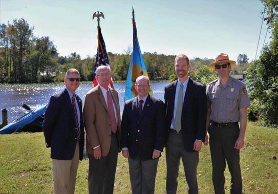
On October 12 in Seaford, Delaware, U.S. Senator Chris Coons joined Seaford Mayor David Genshaw, National Park Service Chesapeake Bay Office officials, and Chesapeake Conservancy to announce plans for a new waterfront park at the site of the old J.B. Robinson Oyster House along the Seaford Riverwalk.
With support from Mt. Cuba Center, Chesapeake Conservancy was able to purchase the nearly 1-acre parcel of waterfront land and donate it to the City of Seaford. Seaford and Chesapeake Conservancy plan to partner with the National Park Service Chesapeake Bay Office to provide public access to the river. Plans include installing a kayak launch, building a small-scale replica of the old J.B. Robinson Oyster House for interpretation, replanting native plants along the Riverwalk, and restoring the shoreline.
The Nanticoke River Watershed Conservancy will hold an easement on the property, which specifies that it will be used exclusively for recreational access. This park will become a gateway to a National Park-like experience along the Nanticoke River and complements other conservation projects along the Nanticoke. Through partnerships with the U. S. Department of Defense Readiness and Environmental Protection Integration Program (REPI), The Conservation Fund, Mt. Cuba Center, and others, Chesapeake Conservancy has completed 14 projects across the corridor linking Vienna, MD, to Seaford, DE, and protected over 1,800 acres. Significantly, these 14 projects link to other previously conserved properties and refuges, creating meaningful swaths of conserved land with a powerful impact on the environment.
“We are thrilled to have this opportunity to celebrate our past—our connection to the Nanticoke River and what it has meant to the people of Seaford,” said Seaford Mayor David Genshaw. “This project shows you what can happen when people with passion come together around a common goal, and Seaford is very happy to be party to it. From Seaford’s early days, it was industry along the river that brought economic successes to our community, and the Nanticoke River will continue
to be an economic driver for our future success as well!”
“This is an important day for the City of Seaford,” said Senator Coons.
“Seaford sits on one of the most beautiful and undeveloped rivers in the Chesapeake Bay, and I want to congratulate Mayor Genshaw, Mt. Cuba Center, the Chesapeake Conservancy, the National Park Service, and everyone who worked hard to secure the land with access for the Captain John Smith Chesapeake National Historic Trail and the future J.B. Robinson Oyster House site along the Seaford Riverwalk. This project will allow more Seaford residents, in addition to other Delawareans and visitors, to access the Nanticoke and see what a treasure Seaford has.”
for building a sewage disposal plant that has now cleaned up the river. It is very rewarding for me to follow in my father’s footsteps and help make the beautiful Nanticoke River more accessible, so thousands of people can enjoy the wonders of our natural environment,” said Larrimore.
“Enhancing public access is a big priority because the more the public enjoys and experiences a resource, whether it be a park, a river, or even a historic site, the more they will care about it,” said Chuck Hunt, superintendent, National Park Service Chesapeake Bay Office.
“It is a great honor to partner with the City of Seaford and the National Park Service on the future of this site,” said Joel Dunn, president and CEO, Chesapeake Conservancy. “We envision a ‘trailhead’ for a national park-like experience to connect us and our children with the beauty of the Nanticoke and the important role it plays in the Chesapeake watershed. What a great place to get out and enjoy an authentic Chesapeake experience on the Captain John Smith Chesapeake National Historic Trail.”
Chesapeake Conservancy Board
Member Randall Larrimore, who grew up in Seaford, has been a major force behind the project. “Sixty years ago, the Nanticoke River was so polluted that it was unsafe. My father was mayor of Seaford then and was responsible
From left to right: Seaford Mayor David Genshaw, Chesapeake Conservancy Board Member Randall Larrimore, U.S. Senator Chris Coons (DE), Chesapeake Conservancy President and CEO Joel Dunn, National Park Service Chesapeake Bay Office Superintendent Chuck Hunt
PHOTO BY KELSEY EVERETT
Controversy over Fones Cliffs Continues
Lawsuit Filed Against Developer of Luxury Resort
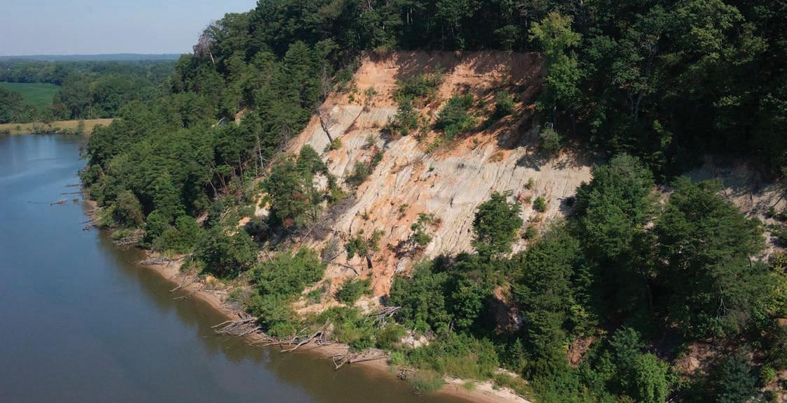
If you have visited Fones Cliffs along the Rappahannock River in Virginia, you know that it is a majestic place that brings to mind what the Chesapeake must have looked like when Captain John Smith encountered the American Indians living here more than 400 years ago.
This 4-mile formation of forested cliffs reaches heights of 80 to 100 feet and is composed of diatomaceous earth formed millions of years ago. This is the ancestral territory of the Rappahannock Tribe. According to the journals of Captain John Smith, Fones Cliffs was the home of three Native American towns and bore witness to an encounter between the Rappahannock and Smith’s English crew. This area is a highlight to those exploring history along the Captain John Smith Chesapeake National Historic Trail and to paddlers traversing the Rappahannock River. It is also designated as a globally significant Important Bird Area for resident and migratory bald eagles and other migratory birds.
Chesapeake Conservancy has been working with partners for the past few years to conserve this special place for future generations, especially in the face of heightened threat of development.
Cliffs Endangered by Development
In 2015, those trying to conserve the cliffs were dealt a blow when the Richmond County Board of Supervisors approved a rezoning request that enabled the development of a large luxury resort and golf course on the previously pristine cliffs.
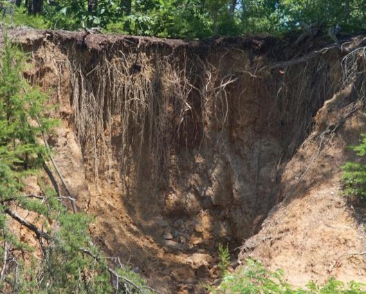
Then in the fall of 2017, the developer illegally cleared 13 acres, scarring the land and leaving the cliffs in peril.
After two significant rain events along Virginia’s Northern Neck in May 2018, massive amounts of cliff face adjacent to the cleared area sloughed off, sending entire trees and tons of sediment to the bottom of the cliff and into the Rappahannock River.
“It was everything we feared, everything we warned could happen—an utter disgrace,” said Joe McCauley, Chesapeake Fellow with the Chesapeake Conservancy, and retired from U.S. Fish and Wildlife Service after a 32-year career that included serving as refuge manager at the nearby Rappahannock River Valley National Wildlife Refuge. “It still haunts me wondering what American Indian archeological resources were lost because of that illegal clearing.
We will never know all that was lost.” Chesapeake Conservancy and partners such as the Chesapeake Bay Foundation and Friends of the Rappahannock, along with concerned citizens, appealed to elected officials to take the violations seriously.
Fones Cliffs, along the Rappahannock River in Virginia, is one of the few places Captain John Smith and the American Indians he encountered there would still recognize today.
PHOTO BY BILL PORTLOCK
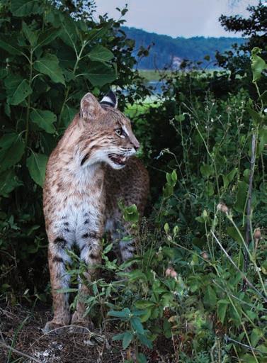
Fones Cliffs provides important habitat for one of the largest concentrations of eagles on the East Coast.
PHOTO BY PETER TURCIK
“It was everything we feared, everything we warned could happen—an utter disgrace.”
- Joe McCauley, Chesapeake Fellow
Lawsuit Against the Developer
By mid-October 2018, Virginia’s Attorney General Mark R. Herring and the Virginia Department of Environmental Quality (DEQ)
announced the filing of a lawsuit against the developers for significant and repeated environmental violations.
“This lawsuit includes some very serious allegations that the developer, Virginia True, repeatedly disregarded its responsibilities to protect the land and waterways around its project, failed to seek and obtain the permits it knew it needed, and continued to cut corners and ignore its responsibilities even after receiving multiple notices of violation,” said Attorney General Herring. “We’re asking the court to put a stop to these violations, and to compensate the Commonwealth for the predictable and needless damage that has been caused.”
“This summer and fall, DEQ closely monitored required compliance at the Virginia True site and addressed violations with the full enforcement authority of our agency, which in this case included referral to the Attorney General’s Office,” said DEQ Director David Paylor. “We are pleased Attorney General Herring is taking this matter as seriously as we are in order to hold Virginia True accountable.”
The Commonwealth’s lawsuit asks the court for an injunction to force Virginia True to comply with environmental laws, for the maximum allowable civil penalties, and for any other relief that the court believes to be appropriate.
“We are very pleased that Attorney General Herring and the Northam Administration are taking this environmental loss seriously. We are hopeful that the penalties will include remediation of the site and will be commensurate with the significant losses of habitat and archeological resources.
a contract on an adjacent 250-acre property to permanently conserve this land, previously envisioned to be the site of 10-story high-rise condominiums and part of the massive development. TCF is working with the U.S. Fish and Wildlife Service (USFWS) to use funds from the federal Land and Water Conservation Fund to purchase the land and transfer it to the USFWS. We are proud to have honored TCF at our fifth annual Champions of the Chesapeake this year for their support of projects such as conserving Fones Cliffs and Werowocomoco.
Need for Support Continues
Thanks to your generous financial support, we have had the capacity to alert the public to this threat of development; testify at local county board of supervisors’ meetings; launch petitions; and catalyze land conservation deals among partner organizations, federal officials, and land owners. Additionally, in 2017, we purchased a parcel of land for the Rappahannock Tribe to once again ensure they have a stake in land where their ancestors lived for hundreds of years before Captain John Smith sailed up the river in 1608 and opened the way for European settlement. Indeed, conserving Fones Cliffs continues to be one of Chesapeake Conservancy’s top conservation priorities.
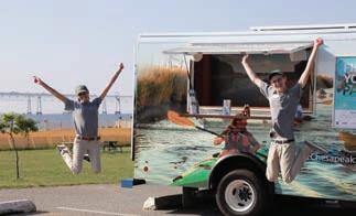
JUMPING ROVING RANGERS
Thank you to the thousands of people who have voiced their support for Fones Cliffs. We remain hopeful that we can permanently protect the cliffs for current and future generations,” said Chesapeake Conservancy President and CEO Joel Dunn.
Conservation Next Door
Meanwhile, at the time of this writing, our partners at The Conservation Fund (TCF) have secured
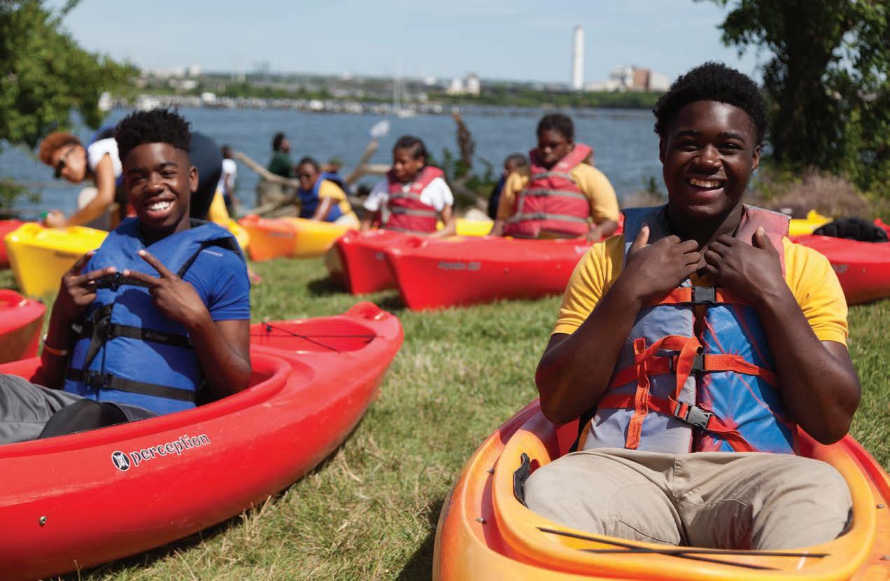
Stephanie Gorham and Michael Bowman took the Chesapeake Roving Ranger, the mobile visitor information center for the Chesapeake Bay Gateways Network and a partnership program between the National Park Service Chesapeake Bay Office and the Chesapeake Conservancy, to 26 locations and events. From June through November 2018, the crew interacted with nearly 3,500 people in Delaware, Pennsylvania, Maryland, and Virginia.
BY PATRICK SMITH
A bobcat caught on a wildlife webcam in 2016 with Fones Cliffs in the background PHOTO BY TIG TILLINGHAST
Illegal clearing led to the collapse of portions of Fones Cliffs after heavy rain. COURTESY PHOTO
PHOTO
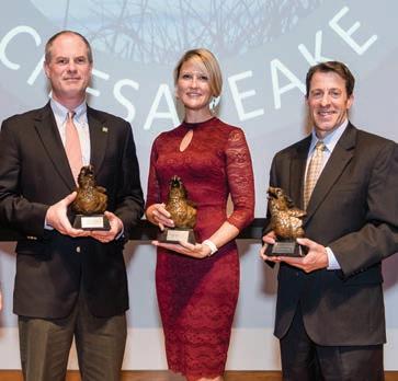
Congratulations to the 2018 Champions of the Chesapeake!
U.S. Department of Defense Readiness and Environmental Protection Integration (REPI) Program
The Conservation Fund
Ecosystem Investment Partners
Thank you to our sponsors!
Intel Corporation
Microsoft Corporation
Beveridge & Diamond, P.C.
Hogan Lovells
RBC Wealth Management
The Conservation Fund
Bank of America
The Campbell Foundation
M&T Bank
Spectra Integration
Molly Joseph Ward
Wetland Studies and Solutions, Inc.
Athens Paper
Herrington Harbour Marinas
Herrington on the Bay Catering
The Martin Architectural Group
The Severn Companies
Shore Bancshares
Total Wine & More
Turner Sculpture
Creating Detailed Stream Maps of Chesapeake Bay Watershed Aids in Restoration Efforts
Grant Funds Conservancy and UMBC Partnership
Thousands of waterways, from major rivers like the Potomac and Susquehanna to tiny headwaters, flow through the Chesapeake Bay watershed. Many of them appear on official stream maps produced by the U.S. Geological Survey, but many others go unrecorded. Because the official maps are incomplete, “if you base management and restoration goals on coarse stream maps, you’re going to miss a big part of the picture,” says Matthew Baker, professor of geography
and environmental systems at the University of Maryland Baltimore County (UMBC).
Chesapeake Conservancy and UMBC were awarded $1.2 million from the Chesapeake Bay Program (CBP) to create a more accurate, updated map for the watershed by applying new stream mapping techniques.
CBP is supporting accurate stream mapping to improve management and implementation of the Chesapeake Bay Total Maximum Daily Load—daily Bay pollution limits set by the U.S. Environmental Protection Agency in 2010. Small streams are often overlooked for restoration activities because they do not show up on the official maps, despite delivering large amounts of nutrient and sediment pollution to the Bay. Updated stream maps will help partners throughout the Chesapeake Bay watershed prioritize restoration efforts and better understand how pollution enters the Bay’s tributaries. Once the mapping team develops a more complete map, they will still have one more crucial step to complete. “A big part of the project is to validate and check the map,” Baker says. “If the stream map isn’t reliable and no one
believes it, then it’s not very useful. So that’s what we’re going to spend a lot of time doing.”
He estimates that about two-thirds of the time spent on the six-year project will focus on quality control. “With Chesapeake Conservancy’s assistance and expertise, we will compare the results of the new automated techniques with data collected from aerial imagery or on the ground at sites around the watershed.”
“Chesapeake Conservancy is a great partner in this context,” says Baker. “They’ve developed a lot of experience generating geographic datasets for the watershed.”
Conservation Outcomes
Having a complete, reliable map is essential for protecting waterways. “If we want to understand how what we do on the landscape influences stream integrity and downstream health in places like the Chesapeake Bay,” Baker says, “then being able to map the connections between human activities on the land and the circulatory water system that delivers their effects to the Bay is paramount.”
Honorees from left to right: Nick Dilks, managing partner, Ecosystem Investment Partners; Kristin Thomasgard-Spence, program director, Department of Defense Readiness and Environmental Protection Integration (REPI) Program; and Larry Selzer, president and CEO, The Conservation Fund.
PHOTO BY MARK HAMILTON
Chesapeake Conservancy and UMBC partnership uses new stream mapping techniques to record headwaters that coarser maps do not show. IMAGE BY CHESAPEAKE CONSERVANCY CONSERVATION INNOVATION CENTER
Donor Spotlight: Patagonia
World-Class Conservation Recognized on a Global Stage
A World Trout Initiative grant from visionary outdoor outfitter Patagonia has recognized Chesapeake Conservancy’s modern approach to restore once abundant trout streams in Pennsylvania. The Conservancy was selected from a global pool of applicants for our cutting edge work to use technology and community-based partnerships to identify and drive targeted restoration on streams so native Eastern brook trout can rebound and thrive.
Patagonia’s World Trout Initiative was founded by owner Yvon Chouinard and author/artist James Prosek in 2005 to protect native habitats, reduce pollution, and preserve natural stream flows. This global program has provided more than $2.3 million in grants since its inception to help support smart, grassroots strategies that create healthier streams and rivers. Chesapeake Conservancy was thrilled to be included among this year’s selected recipients.
“Patagonia is honored to support the Chesapeake Conservancy’s restoration efforts on the Susquehanna River through our World Trout Initiative grants program,” said Ron Hunter, Patagonia’s activism manager.
The Susquehanna River watershed is home to 37,000 miles of streams and rivers in Pennsylvania, with 35% designated as trout waters. Where once abundant trout used to thrive, agricultural pollution has impaired a third of its streams, according to the Pennsylvania Department of Environmental Protection. By using new data and analytics, and with Patagonia’s support, the Conservancy is advancing world-class, new strategies to help zero in on the best opportunities to restore streams and return these native fish to the Susquehanna River.
Rebounding brook trout populations is good news for communities, but also great news for the Chesapeake as brook trout are one of the best indicators of good water quality. By joining forces with local conservation organizations, conservation districts, and restoration professionals, the Conservancy is helping communities shift their actions on the ground where data demonstrates the best chance to meet local goals more quickly.
“We’re so proud to receive global recognition from Patagonia’s World Trout Initiative for our innovative work to help pioneer a new approach to restoration,” said Director of Development Melissa
Conservancy Board & Staff News
Former Virginia Secretary of Natural Resources
Molly Joseph Ward was recently elected to the Conservancy’s Board of Directors. She previously served as special assistant to the president and deputy director of intergovernmental affairs at the White House for President Obama. She is currently serving as treasurer for the city of Hampton, Virginia.
“Molly brings tremendous leadership experience as well as deeply rooted connections to the Chesapeake Bay watershed. We are honored that she has chosen to contribute her time and talent to the Chesapeake Conservancy’s mission,” Douglas Wheeler, chair of the Board, said.
We welcome Patty Allen, our new office manager, bringing 25 years of
administration and human resources experience. Patrick Smith, communications and partnership assistant, and Kelsey Everett, digital resources coordinator, have joined the communications department to help support the National Park Service partnership. LeeAnn King joined the Conservation Innovation Center team as geospatial program manager, along with three new geospatial analysts, Jacob Czawlytko, Katie Walker, and Emily Wiggans Rachel Soobitsky was promoted to geospatial project manager.
Thank you to Michael Bowman and Stephanie Gorham who spent the summer as our seasonal “Roving Rangers,” representing the National Park Service and Chesapeake Conservancy partnership at various high-profile events to inform the public about ways to enjoy the Chesapeake Bay.
Colleen Whitlock, director of administration and Chesapeake
Ehrenreich, Chesapeake Conservancy.
“Patagonia has been such a great partner and supporter. Not only have they provided us with critical resources to drive action on the ground, they also believed in us so much they nominated us as a nonprofit member of the 1 Percent for the Planet network due to our cost-effective and innovative strategies.”
Conservancy’s first full-time employee, accepted a new position with Sultana Education Foundation. “Colleen literally helped build this place from the ground up. There is no doubt in my mind that we would not be where we are today without her help getting us here. She met and exceeded every challenge we threw at her,” said Chesapeake Conservancy President and CEO Joel Dunn.
We also bid a very fond farewell and our heartfelt thanks to several other dedicated employees, including Kate Bohanan, Cassandra Pallai, and Robin Talbot. We wish them well on their next adventures!
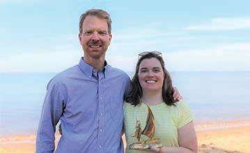
Joel Dunn and Colleen Whitlock PHOTO BY PATRICK SMITH
Molly Joseph Ward COURTESY PHOTO
Restoring habitat for native species through Patagonia’s World Trout Initiative grants program COURTESY PHOTO
716 Giddings Avenue, Suite 42 | Annapolis, Maryland 21401
Let’s Keep in Touch!
443.321.3610
info@chesapeakeconservancy.org
www.chesapeakeconservancy.org
www.facebook.com/chesapeakeconservancy
www.twitter.com/chesconserv
www.instagram.com/chesapeakeconservancy/
www.FindYourChesapeake.com
CHESAPEAKE CONSERVANCY RELIES ON OUR MANY FRIENDS TO PROTECT AND CONSERVE THE CHESAPEAKE’S GREAT RIVERS AND SPECIAL PLACES. YOUR TAX-DEDUCTIBLE CONTRIBUTION OF ANY AMOUNT IS TRULY APPRECIATED. CHESAPEAKE CONSERVANCY HAS A 4-STAR RATING FROM CHARITY NAVIGATOR. OUR TAX ID NUMBER IS 26-2271377.
LEAVE A LEGACY OF THE CHESAPEAKE FOR FUTURE GENERATIONS
Please consider making a special gift to Chesapeake Conservancy by naming the organization in your will or by designating Chesapeake Conservancy as a beneficiary of your bank account, 401(k) or other retirement account, or life insurance policy.
You can help immediately by joining the Chesapeake Stewards Club and providing monthly support for Chesapeake Conservancy’s ongoing habitat and land conservation programs. For more information, call 443.321.3610.