Aleksandra Stankovic, Director of Institutional Giving
Logan Stenger, Project Manager
Susan Stephenson, Director of Federal Business Development
Shannon Thomas, Project Coordinator
Charlotte Weinstein, Senior Geospatial Analyst
Pushing the Boundaries
Every now and then, a breakthrough reminds us why we do this work. Today, I’m thrilled to share one of those moments with you.
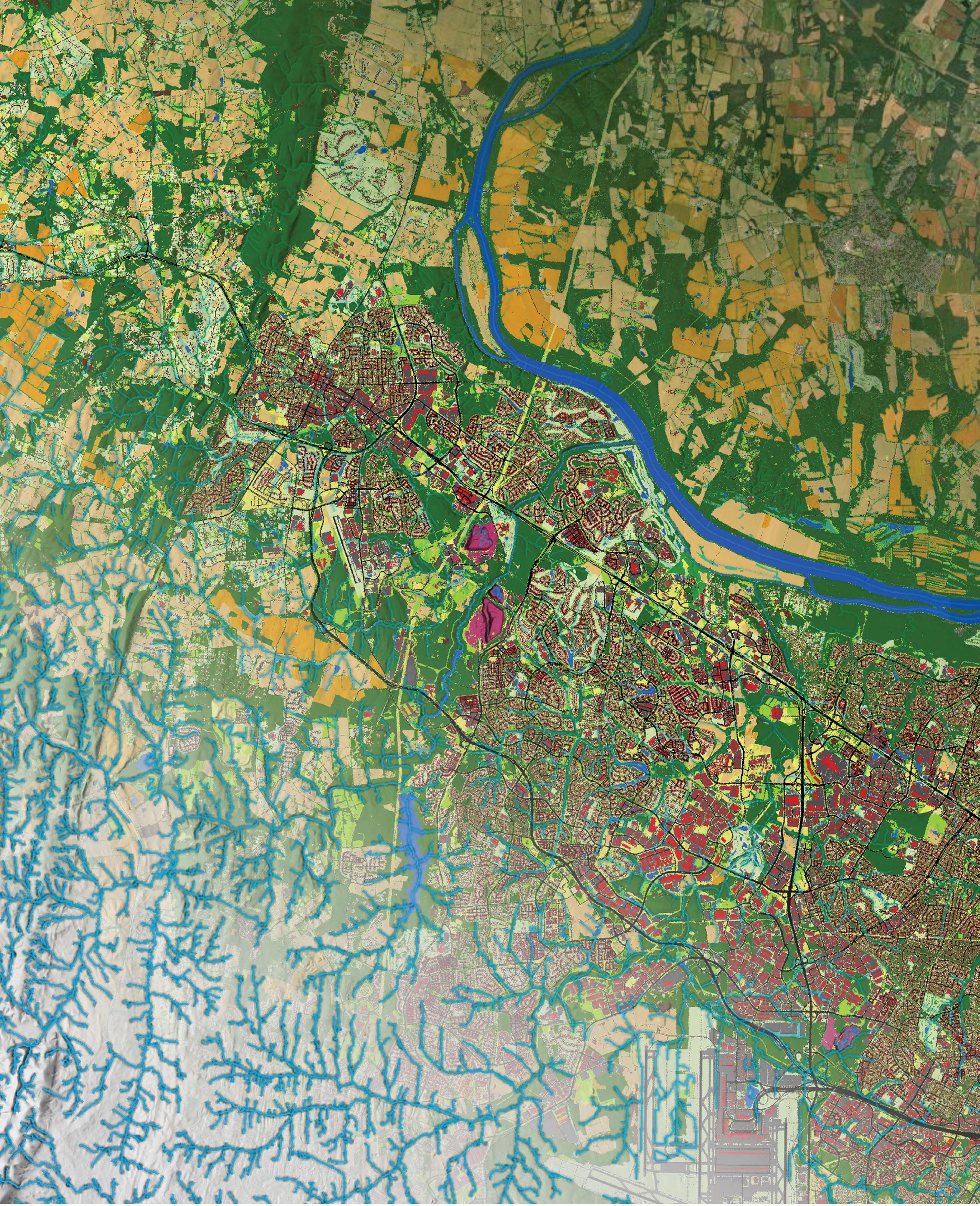
Thanks to our incredible Conservation Innovation Center, in collaboration with the University of Maryland, Baltimore County and the U.S. Geological Survey, we’ve unveiled new Hyper-Resolution Hydrography Data produced for the Chesapeake Bay Program—the most detailed and accurate stream mapping ever created for the Chesapeake Bay watershed. In fact, this novel method marks the first automated hydrographic mapping effort of its kind on such an extensive scale, setting a new benchmark in hydrography. These data more than double the known stream miles, illuminating the network of headwaters and waterways that sustain the Bay. This work is transformative. (See article on page 4.)
Alongside this achievement, our updated High-Resolution Land Use/Land Cover and Change Data, produced with our partners at the U.S. Geological Survey, University of Vermont Spatial Analysis Lab and U.S. Environmental Protection Agency, offers an unprecedented look at how our landscape is being managed and how it has changed over time. With 1-meter resolution and nearly 100,000 square miles mapped, we now have powerful tools to guide restoration, conservation, planning and policy with a clarity we’ve never had before.
These three datasets don’t just help scientists and planners—they empower communities, inform decisions and accelerate progress. They’re a blueprint for a healthier Bay and a more resilient future.
But none of this would be possible without you, our supporters. Your belief in our mission is what powers innovation like this. If you are inspired by what we’ve achieved and where we’re going, I invite you to make a donation today. Your gift helps us continue to push the boundaries of what’s possible for conservation. Together we are turning data into action and maps into milestones.
Rent
Our Conference Room
Earl Conservation Center 1212 West Street, Annapolis, MD 21409
119th Congress to Consider Chesapeake National Recreation Area
On April 10, 2025, U.S. Sen. Chris Van Hollen (D-Md.), along with Sens. Mark Warner (D-Va.), Tim Kaine (D-Va.) and Angela Alsobrooks (D-Md.), reintroduced the Chesapeake National Recreation Area Act (S. 1408) in the 119th Congress.
Previously, on December 18, 2024, the U.S. Senate unanimously passed the Chesapeake National Recreation Area Act (S. 2620). However, the House of Representatives did not pass the bill before leaving for the holidays as the 118th Congress came to an end.
“For more than 30 years, the idea of a national park unit dedicated to the Chesapeake Bay has inspired advocates and communities
alike. This landmark legislation will honor the Bay’s rich history, expand public access and ensure that all who live, work and visit here can continue to cherish and protect this national treasure for generations to come,” said Chesapeake Conservancy Interim President and CEO EJ Amyot.
“We are grateful to Sen. Van Hollen for continuing the momentum by reintroducing the Chesapeake National Recreation Area Act, and we look forward to working with him, Sens. Alsobrooks, Kaine and Warner and the bipartisan Chesapeake Bay congressional delegation,” Amyot added.
PROFESSOR AND PHILANTHROPIST
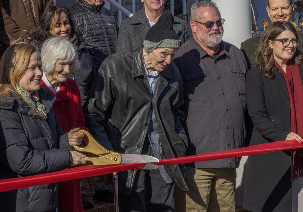
James Arthur Earl 1932-2025
Philanthropist James Arthur Earl, known to many as “Jim,” passed away on March 23, 2025, in Annapolis, Maryland. Earl and his wife of 70 years, Sylvia, were longtime supporters of Chesapeake Conservancy.
Jim and Sylvia Earl became residents of Anne Arundel County in 1995. He retired in 2000 after teaching physics and astronomy at the University of Maryland for 35 years. They made their presence known through their interest in and support of the arts, the environment, education and health care.
Through the Helena Foundation, which honors his mother, Margaret Helena Earl, Jim and Sylvia created a lasting legacy for conservation and collaboration by establishing the Earl Conservation Center. Located at 1212 West Street, Annapolis, the Earl Conservation Center
opened in 2024 as home to several nonprofit conservation organizations, including Chesapeake Conservancy, Blacks of the Chesapeake Foundation, Chesapeake Legal Alliance and Maryland Association for Environmental and Outdoor Education.
The Earls’ decision to provide a collaborative workspace for local conservation nonprofits will profoundly affect Chesapeake Bay conservation for future generations.
“We are deeply saddened by the passing of James Earl, a true visionary whose generosity and dedication to conservation have left an enduring impact on the Chesapeake Bay,” said Chesapeake Conservancy Interim Chief Executive Officer EJ Amyot. “His unwavering support strengthened the conservation community, and his legacy will continue to inspire efforts to protect and restore the Chesapeake for generations to come. We are forever grateful for his contributions, and our thoughts are with Sylvia and the entire Earl family during this difficult time.”
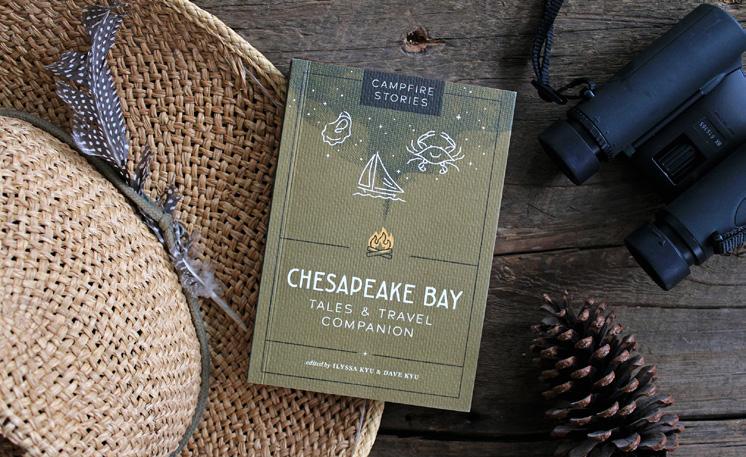
Chesapeake Conservancy Contributes to New Campfire Stories Book Featuring the Chesapeake Bay
Chesapeake Conservancy is proud to have provided information and insights for Campfire Stories: Tales and Travel Companion edited by Ilyssa and Dave Kyu, the latest installment in the bestselling Campfire Stories series published by Mountaineers Books. This beautifully curated volume continues the tradition of honoring America’s natural wonders through storytelling—this time highlighting the rich and diverse landscapes of the Chesapeake Bay.
Blending timeless tales with practical travel advice, the book invites readers on a journey through the Bay’s history, culture and ecology. These tales are then followed by a mini-guide: community-sourced recommendations for outdoor activities, cultural landmarks and historical points of interest, as well as tips on how to best travel lightly and respectfully through the Chesapeake region.
James Arthur Earl (center in hat) at a December 2024 ribbon cutting celebrating the Earl Conservation Center photo by sue buyaskas
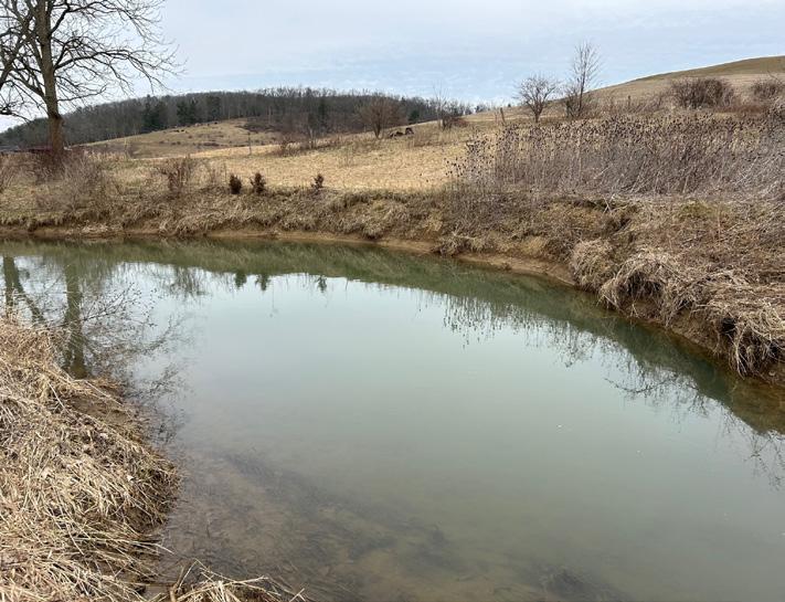
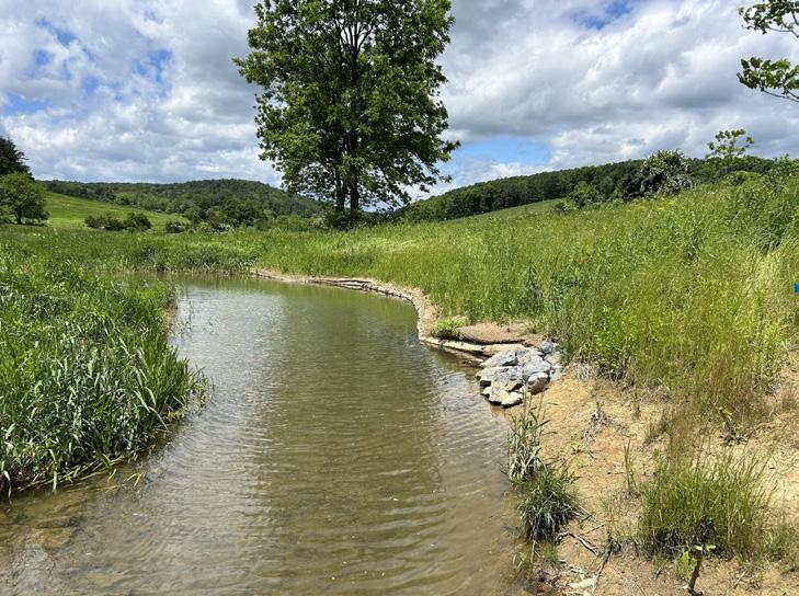
A Clearer Picture of the Chesapeake’s Changing Landscape
For the past six years, Chesapeake Conservancy’s Conservation Innovation Center and partners have collaborated to update High-Resolution Land Use/Land Cover and Change Data for the Chesapeake Bay Program. Also, for the first time, Hyper-Resolution Hydrography Data precisely map the location, size and connectivity of streams, ditches and other waterways across the watershed.
Land Use and Land Cover Data and Change Data
The updated High-Resolution Land Use/Land Cover Data and Change Data, now available for 2013/2014, 2017/2018 and 2021/2022, provide a detailed understanding of how the land of the Bay watershed is being managed and how it has changed over time.
The updated data provide an innovative 1-meter resolution characterization of the watershed and its land types, enabling decision makers to more precisely target their strategies for Bay restoration. The data include 56 detailed land-use classes, such as forest, cropland and roads, across 99,000 square miles with 95% accuracy. Available to everyone, including county and state planners and conservation groups, these data can be widely used to address complex land management challenges, community planning, human safety planning around flooding, conservation efforts and environmental restoration efforts across the Chesapeake Bay watershed.
The updated 1-meter resolution change data track patterns of development, resource extraction, agriculture and natural landscape change over the same time periods. Overall, these data capture 96% of land use change with 77% accuracy. These data offer crucial insights into the patterns of development, habitat change and environmental effects which, in turn, inform evidence-based strategies and policies for accommodating economic and population growth while restoring and maintaining the health of the Chesapeake Bay. Later this summer, following evaluation of the data, the Chesapeake Bay Program will update changes to the amount of tree canopy, forest cover and impervious surface in the watershed.
“High-resolution land use and land cover data and hyper-resolution hydrography data are foundational, authoritative and game changing to environmental restoration and conservation,” said Peter Claggett, research geographer with the U.S. Geological Survey and coordinator
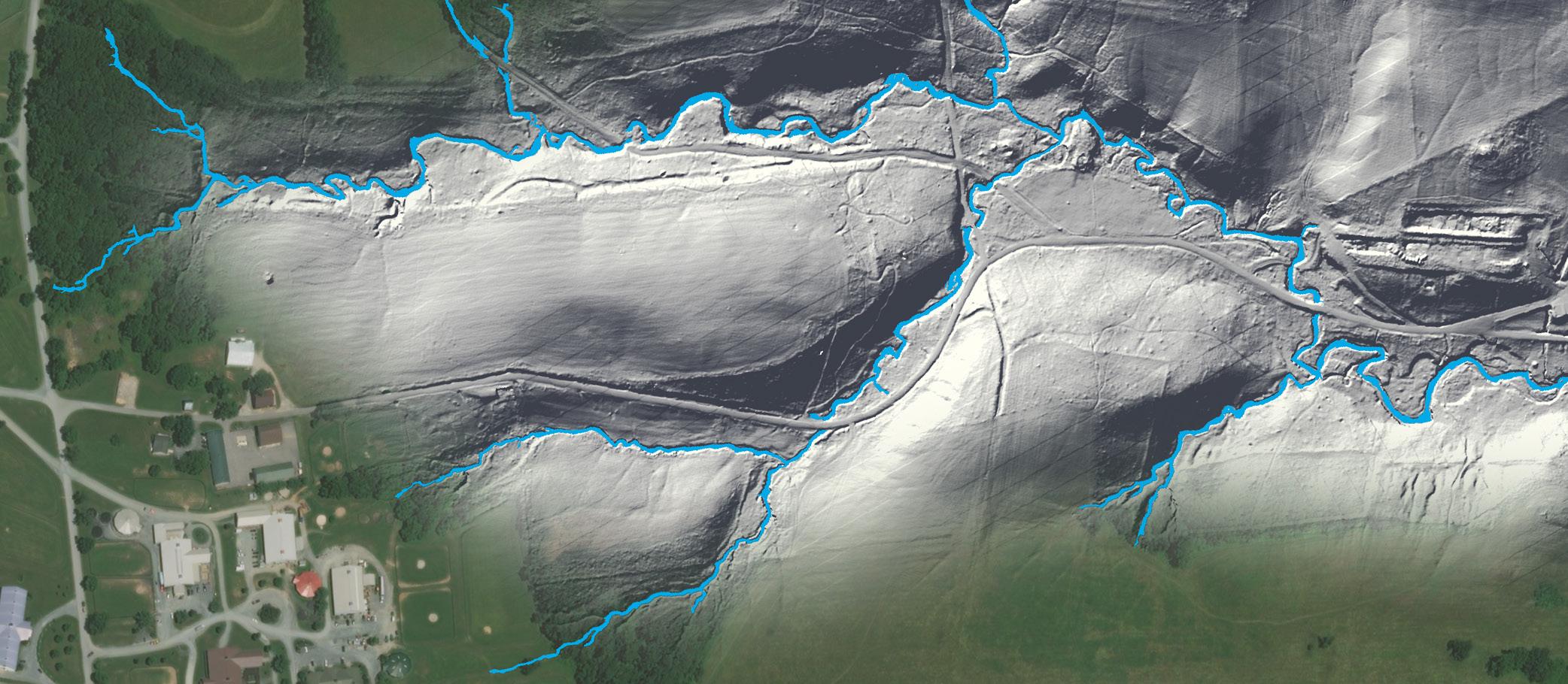
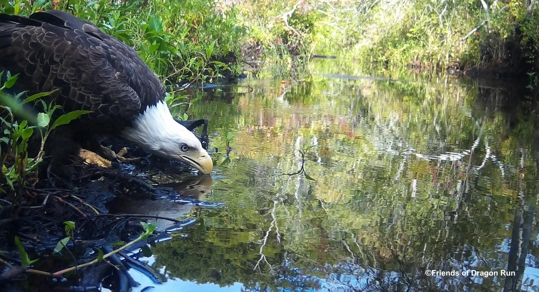
Hyper-Resolution Hydrography Data Most Accurate Stream Map in Chesapeake History
The new Hyper-Resolution Hydrography Data more than doubles the number of stream channel miles compared to existing national data, providing the most comprehensive inventory of the watershed’s stream and ditch network to date. The data precisely locate stream channels, include attributes of channel dimensions and are 94% accurate for streams represented by existing national data. They are 67–82% accurate for previously unmapped streams with accuracy rates increasing for larger streams. This detailed, accurate accounting of the stream network provides insights into how the land is connected to the conditions of streams and the Bay. A variety of environmental challenges that state and
of the Chesapeake Bay Program’s Land Use Workgroup. “The data are foundational to a wide variety of environmental assessments and geographic analyses because they describe the human-modified and natural landscape and how both have changed over time. The data are authoritative because they are both accurate and transparent with easily recognizable features such as roads, structures and tree canopy. Most importantly, the data are game changing, enabling the identification of restoration and conservation opportunities throughout the Chesapeake Bay watershed at local scales down to individual farms, forest tracts and developments.”
Partners working on both the High-Resolution Land Use/Land Cover Data and Change Data include the Chesapeake Conservancy, U.S. Geological Survey, University of Vermont Spatial Analysis Lab and U.S. Environmental Protection Agency.
local governments face are informed by these data, including flood control, fish passage, stream restoration, pollutant transport and other water resource and aquatic habitat concerns.
“We now have tools to drive the most efficient and effective conservation of the Chesapeake Bay watershed yet.”
— michael evans , ph d ., deputy director and lead data scientist at the chesapeake conservancy ’ s conservation innovation center
Three new datasets produced by Chesapeake Conservancy’s Conservation Innovation Center and partners bring improved precision to Bay restoration. Shown here, the latest hyper-resolution hydrography data identify streams and headwater drainages with greater detail than ever before, more than doubling the number of stream miles compared to existing data. image by chesapeake conservancy’s conservation innovation center
“We now have tools to drive the most efficient and effective conservation of the Chesapeake Bay watershed yet,” said Michael Evans, Ph.D., deputy director and lead data scientist at the Chesapeake Conservancy’s Conservation Innovation Center. “The new hyper-resolution hydrography data will transform how the Chesapeake Bay is managed and restored. This innovative approach to stream mapping reveals more than twice as many stream miles than were previously mapped. Most of these are small headwaters—the capillaries that play an outsized role in linking what happens on the land to conditions in the Bay. Combined with the detailed understanding of land use dynamics that three time periods of high-resolution land cover data provide, decision makers can evaluate policies, forecast future scenarios and take actions to improve water quality with unprecedented precision.”
Partners working on this dataset include University of Maryland, Baltimore County, U.S. Geological Survey and Chesapeake Conservancy.
The High-Resolution Land Use/Land Cover Data and Change Data, as well as the Hyper-Resolution Hydrography Data, are used to track progress toward multiple goals and outcomes in the Chesapeake Bay Watershed Agreement and inform Chesapeake Bay Total Maximum Daily Load
planning efforts that will help watershed jurisdictions make progress toward meeting their pollutant reduction goals. According to the project partners, no where else in the country has data covering such a large area of this quality and spatial, temporal and categorical resolution. All three datasets are open source and provided free for anyone to use at the U.S. Geological Survey ScienceBase-Catalog or the Chesapeake Conservancy website.
“Maps such as these do more than show locations. They are tools for a host of societally relevant applications and a record of environmental conditions in time,” said Matthew Baker, Ph.D., professor of geography and environmental systems at the University of Maryland, Baltimore County. “The good news is that the time increment between the dusty old and the shiny new maps is shrinking. The Bay Program is supporting new ways of accelerating this process to the point where such maps can be used to help monitor the dynamics of landscape change as well as its status. What’s exciting is that the new mapping procedures are not just making mapping easier, they are also providing useful new measurements, leading to further discovery and expanding our understanding of both the natural and built environment.”
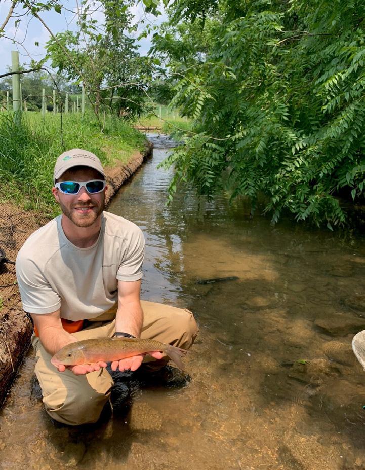
If You Build It, They Will Come A Cool Full-Circle Moment in My Conservation Career
By Chesapeake Conservancy Project Manager Logan Stenger
Back in 2020, I had conversations with a dairy farm in Pennsylvania’s northern Huntingdon County that set the stage for one of the largest stream restoration projects I’ve participated in: 4,000 feet of stream restoration, 13.5 acres of riparian buffer and more than 2,000 trees planted. Fast forward to winter/spring 2024, and that vision became a reality.
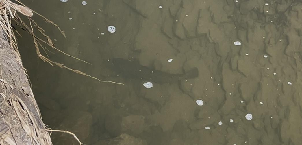
Before the restoration work began, I partnered with biologists from the Pennsylvania Department of Environmental Protection to conduct a fisheries assessment. While we found nearly 14 species, we didn’t collect a single trout in this agriculturally impaired cold-water tributary.
One year post-restoration, I revisited the site with Juniata College environmental science students and witnessed something incredible— a trout taking refuge beneath one of the habitat structures we had installed. This fish likely swam up from the larger trout stream nearby, a clear sign that the restored habitat is doing exactly what it was meant to do.
Conservation works. Seeing it firsthand? That’s the best part. Hopefully, the system will continue to improve and recover! Thank you to all the partners involved in the project: U.S. Fish
and Wildlife Service State College, Pennsylvania Office, Western Pennsylvania Conservancy, Huntingdon County Conservation District, Pennsylvania Department of Environmental Protection, Pennsylvania Department of Conservation and Natural Resources, National Fish and Wildlife Foundation, Hamer Foundation, and Chesapeake Conservancy.
Can you spot the trout? video still by logan stenger
A Logo Comes to Life
The Logo Whisperer
Chesapeake Conservancy’s Senior Vice President of Communications Jody Couser approached Scott Combs with a big ask: create a new logo that would capture the spirit of the organization and the Chesapeake Bay.
“My goal was to create a logo for Chesapeake Conservancy that would reflect a healthy Chesapeake Bay and the joy and interconnectedness of this beautiful place— among people and wildlife, recreation and the economy,” said Couser. Her creative challenge to Combs? Make it “swag-worthy.” She added, “I also wanted this logo to be stylish and appeal to our current and future supporters.”
Combs, a former executive at a major advertising agency turned independent consultant, was up for the challenge. He immersed himself in the Chesapeake,
interviewing board members, staff and supporters to understand Chesapeake Conservancy’s mission and values.
When it was time to present his concepts, Combs met with Couser virtually. “He showed me the first logo on the screen, and I said, ‘That’s it. That’s the one,’” Couser recalled. “He went on to show a few more options, and we advanced all of them to the next phase of review with my colleagues—but sure enough, we ultimately selected that very first design.”
The final logo tells a powerful story. A healthy Chesapeake Bay supports menhaden, which in turn sustain the osprey soaring overhead. The water is clean and inviting for recreation, for wildlife and for those who depend on it for their livelihoods. Combs, whom Couser dubbed “the logo whisperer”—noting how rare it is to nail a concept on the first try— has since designed several more logos for
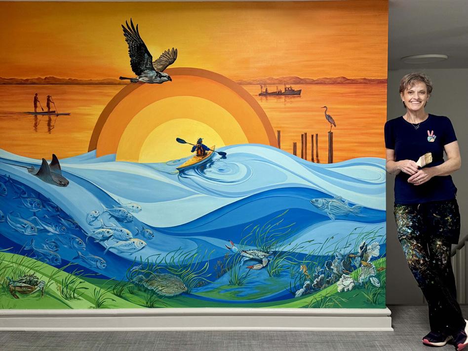
The Mural Artist
Chesapeake Conservancy’s logo comes to life in a breathtaking new way in a 75-foot mural at the Earl Conservation Center, which is home to Chesapeake Conservancy, Blacks of the Chesapeake Foundation, Chesapeake Legal Alliance and the Maryland Association for Environmental and Outdoor Education.
Made possible through the generosity of the Earl family (see related story, p.3), the mural was commissioned to welcome visitors and inspire staff. More than just a work of art, it serves as a visual narrative of the Bay’s beauty, resilience and the importance of protecting it for future generations. The artist, Gayle Mangan Kassal, an Annapolis resident known for her vibrant and dynamic murals, has created art for hospitals, schools and institutions from Boston to Washington, D.C. She is also a highly regarded educator and a member of the Maryland Pastel Society and Annapolis Art Alliance.
The mural spans nearly the entire length of the first floor and features iconic locations such
as Cape Henry, Fones Cliffs, Blackwater National Wildlife Refuge and the region’s tributaries and wetlands, along with native flora and fauna. Each scene flows into the next, creating a seamless journey through the Chesapeake’s diverse ecosystems.
Kassal worked in close collaboration with Chesapeake Conservancy staff, environmental experts and naturalists to ensure every scene resonated ecologically.
Chesapeake Conservancy’s programs and for the United4CNRA coalition. He continues to support Chesapeake Conservancy with brand messaging and strategic communications. Explore more of his work at: scottcombs. myportfolio.com/projects
“It was an honor to meet James Earl, himself a talented artist, and to bring the Chesapeake Conservancy’s logo and mission to life,” Kassal said.
“Spending so much time in Earl Conservation Center, I have come to know the passionate conservationists who work here. I hope the mural inspires them and honors the Earl family legacy. The Chesapeake Bay is a special place for my family and my chosen home.”
She added, “I’m especially grateful to the Chesapeake Conservancy team, to Lauren
Peeler Brice and to Broadneck High School student Addison Thornton for supporting my research into the many stories, species and landscapes that are woven into the design.”
Chesapeake Conservancy welcomes you to come see the beautiful mural. Please let us know you’re coming at info@chesapeakeconservancy. org.
Visit gaylemangankassal.com to see more of Kassal’s stunning artwork.
Scott Combs courtesy photo
Mural artist Gayle Mangan Kassal courtesy photo
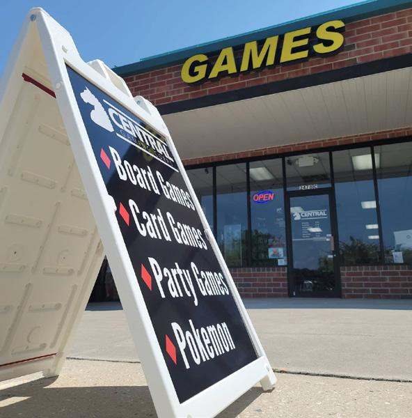
Game On for Conservation
Central Gaming Corps in Centreville, Maryland, recently hosted a charity gaming tournament with a mission to support the Chesapeake Conservancy. The event brought together local tabletop gaming enthusiasts for a day of fun, community and environmental impact and to raise funds to support our work to conserve land, restore streams and empower with data.
Central Gaming Corps serves as a welcoming hub where players of all ages gather for weekly events, including card games, board games, role-playing adventures and strategy tournaments. It’s a place where friendships are developed across game tables and where shared passions unite a diverse community.
Board and Staff News
Chesapeake Conservancy is pleased to welcome Michael T. Reynolds and returning board member Randall Larrimore to the Board of Directors. In 2024, Randall Larrimore was named an emeritus director after serving as board chair since 2020. His continued leadership and commitment are deeply appreciated.
Reynolds is currently an environmental director for a large homeowners association in Reston, Virginia. He retired in 2024 as the deputy director of external and congressional affairs for the National Park Service (NPS). Reynolds spent nearly 40 years as a leader in various NPS positions throughout the United States, including Cape Cod, Fire Island, Mojave, Yosemite and Olympic national parks with
“Central Gaming is all about getting unplugged and getting back to being face to face with our friends and family. We are a community that’s built in the now, not a text that we can get back to later,” said Daniel Meeks, the shop’s owner.
Chesapeake Conservancy is grateful for the dedication and generosity of partners like Central Gaming Corps and its patrons. Through grassroots events like this one, local champions are helping to ensure a healthier future for the Chesapeake Bay.
To learn more about community-led support for conservation or to host your own fundraiser, contact Chesapeake Conservancy’s Director of Individual and Major Gifts J.T. Dean at jtdean@chesapeakeconservancy.org.
Check out our many accomplishments
in the FY 2024 Annual Report, now available at chesapeakeconservancy.org (see publications).
Thank you to our incredible donors who make our work possible!
regional office leadership assignments in Denver, Philadelphia and Omaha among others. He has held different appointments at headquarters in Washington, D.C., including head of workforce and training programs and later deputy of operations and the acting director of the agency in 2017.
Ed Hatcher was elected to the position of vice chair, and Philip Tabas was elected to the position of secretary. Chesapeake Conservancy thanks Michael Brubaker, Chief Anne Richardson and John Reynolds who have concluded their board service.
and trail at Terrapin Nature Park in Stevensville, Maryland.
Aleksandra Stankovic has joined the team as the director of institutional giving. Previously, Stankovic served for two decades in a variety of fundraising roles at The Nature Conservancy.
We thank AmeriCorps member Zach Cline, Director of Institutional Giving Allison Anderson and seasonal bilingual rangers Amy Bennett and Hilda Zepeda Esquina for their service.
Show Your Support for Chesapeake Conservancy!
Visit our online store and stock up for summer! shopchesapeakeconservancy.org
who loves to visit the many beautiful beaches throughout the watershed, has created a personal website showcasing more than 100 Chesapeake beaches. Terrapin Nature Park is listed as Beach #4. Explore her project at chesapeakebeaches.weebly.com
Lisa Spallitta was promoted to director of finance and IT. Senior Vice President of Communications Jody Couser and Director of Chesapeake Tributary Strategies Carly Dean celebrated their 10-year anniversaries.
Michael T. Reynolds courtesy photo
Staff honored Couser’s milestone and celebrated Earth Day by spending the afternoon cleaning up the beach
Couser,
Chesapeake Conservancy Earl Conservation Center 1212 West Street
chesapeake conservancy relies on our many friends to protect and conserve the chesapeake’s great rivers and special places. your tax-deductible contribution of any amount is truly appreciated. chesapeake conservancy has a 4-star rating from charity navigator. our tax id number is 26-2271377. our cfc id number is 27293.
SAVING SPECIAL PLACES FUND
The Saving Special Places Fund is a restricted, revolving fund dedicated solely to protecting at-risk lands across the Chesapeake Bay watershed. With your support, Chesapeake Conservancy and our partners can act quickly to compete with developers and permanently conserve lands critical for biodiversity, clean water and public access.
Help us save these irreplaceable places—before it’s too late.