International Research Journal of Engineering and Technology (IRJET) e-ISSN: 2395-0056 Volume: 06 Issue: 12 | Dec 2019
www.irjet.net
p-ISSN: 2395-0072
Proposed Design for 3D Map Generation Using UAV Tanaya Bagade1, Archana Kadam2, Nikhil Garg3, Ashwin Alex4, Shreya Aglave5 1 2
Tanaya Bagade, Dept. of Computer Engineering, PCCOE, Maharashtra, India
Asst Professor. Mrs. Archana Kadam, Dept. of Computer Engineering, PCCOE, Maharashtra, India 3 4
Nikhil Garg, Dept. of Computer Engineering, PCCOE, Maharashtra, India
Ashwin Alex, Dept. of Computer Engineering, PCCOE, Maharashtra, India
5
Shreya Aglave, Dept. of Computer Engineering, PCCOE, Maharashtra, India ---------------------------------------------------------------------***---------------------------------------------------------------------
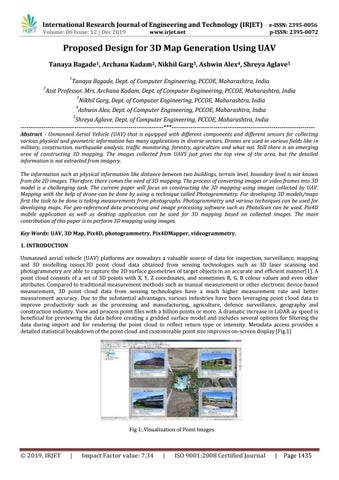
Abstract - Unmanned Aerial Vehicle (UAV) that is equipped with different components and different sensors for collecting various physical and geometric information has many applications in diverse sectors. Drones are used in various fields like in military, construction, earthquake analysis, traffic monitoring, forestry, agriculture and what not. Still there is an emerging area of constructing 3D mapping. The images collected from UAVS just gives the top view of the area, but the detailed information is not extracted from imagery. The information such as physical information like distance between two buildings, terrain level, boundary level is not known from the 2D images. Therefore, there comes the need of 3D mapping. The process of converting images or video frames into 3D model is a challenging task. The current paper will focus on constructing the 3D mapping using images collected by UAV. Mapping with the help of drone can be done by using a technique called Photogrammetry. For developing 3D models/maps first the task to be done is taking measurements from photographs. Photogrammetry and various techniques can be used for developing maps. For geo-referenced data processing and image processing software such as PhotoScan can be used. Pix4D mobile application as well as desktop application can be used for 3D mapping based on collected images. The main contribution of this paper is to perform 3D mapping using images. Key Words: UAV, 3D Map, Pix4D, photogrammetry, Pix4DMapper, videogrammetry. 1. INTRODUCTION Unmanned aerial vehicle (UAV) platforms are nowadays a valuable source of data for inspection, surveillance, mapping and 3D modelling issues.3D point cloud data obtained from sensing technologies such as 3D laser scanning and photogrammetry are able to capture the 3D surface geometries of target objects in an accurate and efficient manner[1]. A point cloud consists of a set of 3D points with X, Y, Z coordinates, and sometimes R, G, B colour values and even other attributes. Compared to traditional measurement methods such as manual measurement or other electronic device-based measurement, 3D point cloud data from sensing technologies have a much higher measurement rate and better measurement accuracy. Due to the substantial advantages, various industries have been leveraging point cloud data to improve productivity such as the processing and manufacturing, agriculture, defence surveillance, geography and construction industry. View and process point files with a billion points or more. A dramatic increase in LiDAR ay speed is beneficial for previewing the data before creating a gridded surface model and includes several options for filtering the data during import and for rendering the point cloud to reflect return type or intensity. Metadata access provides a detailed statistical breakdown of the point cloud and customizable point size improves on-screen display [Fig.1]
Fig 1:.Visualization of Point Images
Š 2019, IRJET
|
Impact Factor value: 7.34
|
ISO 9001:2008 Certified Journal
|
Page 1435