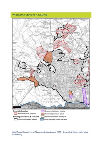
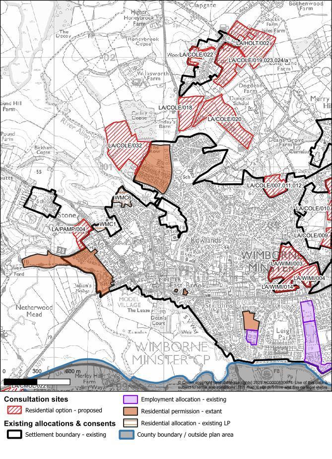
486 | Dorset Council Local Plan consultation August 2025 - Appendix A: Opportunity sites for housing
LA/COLE/018 - Walford Farm & Longhow (West)
Site name
Site reference
Site area (ha)
Parish/Settlement
Walford Farm & Longhow (West)
LA/COLE/018
4.6 ha
Wimborne / Colehill
Proposed uses (estimated number of homes/capacity) Around 82 homes
Greenfield/Brownfield
Considerations
Summary
Proposal Around 82 homes.
Specific design requirements
Natural environment and ecology
Greenfield
Edge of town location. Adjacent to existing residential development.
The site is in agricultural use.
Ecological mapping covers woodland and extends into field and boundaries.
Potential priority habitat hedgerows, trees, woodland, scrub and watercourse. Potential protected species onsite.
Records of priority species.
The site is within 5km of Dorset Heathland.
Proposed approach
Appropriate density of development for edge of town location.
Retain and buffer hedgerows, trees, woodland and scrub. Further ecological survey to identify priority habitats.
Retain important ecological features.
Retain and enhance ecological network.
Potential need for lighting strategy.
Provide mitigation strategy for this protected species.
Provide mitigation for recreational impacts on heathlands & air pollution. Heathland infrastructure project is likely to be required.
Landscape and visual The site is relatively flat. No comments yet.
Heritage
Potential direct or indirect impacts (setting) on nondesignated heritage assets including assets with archaeological interest.
Sensitive design to avoid or minimise conflict between potential development and the heritage assets designation (including its setting).
512 | Dorset Council Local Plan consultation August 2025 - Appendix A: Opportunity sites for housing
Flood risk
Amenity, health, education
Transport (access and movement)
Significant archaeological remains found on site to south indicate high archaeological potential.
There is a significant area of surface water/ fluvial flood risk modelled to impact the north of the site.
Watercourse runs through the site.
Potential need for additional school spaces in this location, if cumulative development for the area is over 1,000 units.
Need for suitable vehicular access and pedestrian/cycle connections.
Potential cumulative impacts on the road network; on the A31 Merley and Canford Bottom Roundabouts.
Pre-determination archaeological assessment and evaluation required.
Locate development outside areas affected by flood risk. Where necessary apply the sequential and exceptions test and consider measures to control, manage and mitigate flood risks over development’s lifetime.
Delivery of additional school capacity through provision of a site and/or financial contributions to meet need.
Provision of vehicular, cycle, and pedestrian access, linking in with existing cycle routes.
Improvements to the existing footway including missing link to be provided where layby is.
Need to assess the cumulative impact on Canford Bottom roundabout.
Green Belt (if applicable)
The site lies within the Green Belt.
Assess whether development can be fully evidenced and justified, and if there are exceptional circumstances for changes to Green Belt boundaries.
513 | Dorset Council Local Plan consultation August 2025 - Appendix A: Opportunity sites for housing