A Proposal for Nature Based Solutions
within the development of the Hereford City Masterplan
Issues
• Pressure to increase urban housing
• Increasing flooding throughout the Hereford City
• Pollution and poor water quality in the Wye and its tributaries in Hereford
• Loss of biodiversity and blue green infrastructure
• Threats to the city’s historic heritage
This report has been written by volunteer members of the City Branch of Herefordshire Wildlife Trust (HWT). The branch was formed in 2017 in recognition of a need to contribute to maintaining and improving the city's blue/green infrastructure and help address the climate change and biodiversity emergencies. With this focus in mind, the Hereford Yazor Brooks Restoration Project (HYBRP) was initiated as an HWT project. The authors of this report are listed at the end of this paper and are all HWT City Branch committee members and HYBRP volunteers. The authors have drawn on observations and analysis from HYBRP's wide range of volunteers and partners (see Appendix at end)
Herefordshire Council Policies and Responsibilities
The Hereford City Masterplan includes the Merton Meadow site and the former Essex Arms Sports Ground – an area of interest for Herefordshire Wildlife Trust due to its potential for flood mitigation and as an urban nature reserve. We recognise that there is a considerable need to provide more affordable social housing in the city. At the same time, there is a general recognition that urban flooding is of increasing concern. These twin pressures impact on the Hereford City Masterplan.
The Essex Arms Site is a small part of a large, dynamic catchment that is subject to the impact of global climate change. It is important that planning and development of the Essex Arms Site is carried out with consideration as to how the site connects in this “big picture” and that many of these connections are far from fully understood. Any planning for urban development on these city centre sites must also consider developments elsewhere in the catchment.
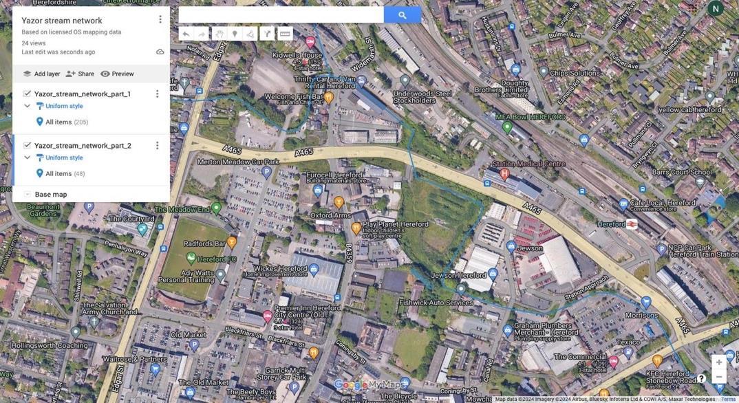
A detailed interactive Google Map of the Yazor/Widemarsh/Eign Brook catchment in Hereford can be accessed here
Herefordshire Council has policies that have determined the balance of housing, roads and green infrastructure across Hereford. Policy HD2 for housing in Herefordshire Council’s Core Strategy tells us that “maintaining and enhancing the city’s historic heritage and environmental assets will be high priority issues”. Policies LD1, LD2, LD3, SD3 and SD4 support this by focusing on landscape, biodiversity, river water quality etc.
Essex Arms Site / Merton Meadows – Flooding
The Hereford Yazor Brooks Restoration Project research, observations and analysis suggest that preventing flooding on the Essex Arms site will not be possible – it is the most low-lying land of the Yazor corridor.
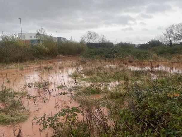
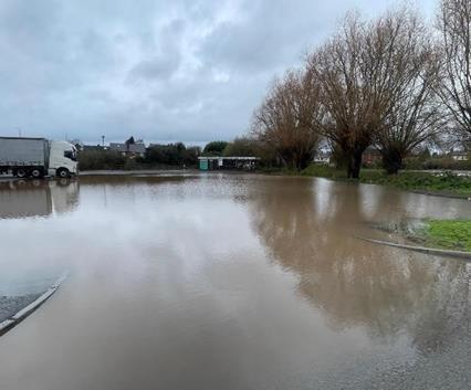
Flood risk today is determined by current land use and land use history Climate change means that we are now prone to more frequent, longer lasting and more intense rainfall events. Below are a few images of flooding on the Essex Arms site and Merton Meadows. Our archive goes back decades, but notable is the recent increase in the frequency of flooding.
Essex Arms site, looking towards Hereford Medical Centre 16/02/2024
Meadows car park N of City Link Rd, flooded on 24/11/24
The
Merton
A Flood Alleviation Scheme to reduce flooding in central Hereford opened in 2012. This took a proportion of water from Yazor Brook at Credenhill - west of Herefordand diverted into the Wye at Swainshill However, flooding in central Hereford still occurs, especially near open or culverted water courses. Additional fluvial inputs to the Yazor Brooks system between Credenhill and central Hereford may not have been considered and may be adding to the amount of water flowing into the central area. The Ayles Brook is a northern tributary of the Widemarsh Brook and has seen an increase in flow to unprecedented levels with the causes under investigation. Realtime changes in levels of Yazor Brook and Eign Brook can be followed here
Where flows are now underground, they may still contribute to flood risk if they keep the water table high and come to the surface during wet weather. Where the water table is above a relatively impermeable layer, water from heavy rainfall may only dissipate slowly. As a result, excess rainfall can increase flood risk substantially in unexpected locations.
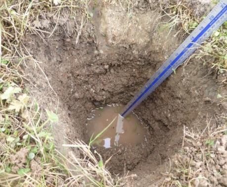
A pit dug on the Essex Arms Site on a dry day, 28.10.21 reached groundwater at a depth of 45cm
The Yazor Brooks system has a low gradient through central and southeast Hereford to the Wye, so flooded channels are slow to carry water to the river, especially when partially blocked by debris, vegetation or other obstacles When the river Wye is in spate, floodwater is known to back up the Yazor system along the Eign Brook as far as Hereford Hospital. On the Essex Arms Site the water table may remain high – often above the ground surface - for extended periods. Although flooding from groundwater is apparently unlikely, groundwater levels themselves can affect how rapidly flood water recedes.
Underground pipes have finite capacity and may suffer from blockage by debris or leakage. It follows that any assessment of flood risk across Hereford should consider what is known about all buried and filled-in channels, as water may still be moving through them underground on historic courses.
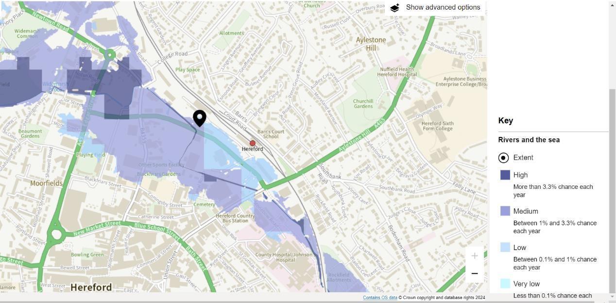
Herefordshire Council map of potential flood depths with Flood Alleviation Scheme in place. For 1% Annual Exceedance Probability events. Note potential depths at the EAS
Notes from Herefordshire Council’s monthly flood risk management meetings with EA and BBLP can be found here.
Map from Government website showing largest areas with highest flood risk are at Westfields, Merton Meadow and Essex Arms site.
How historic hydrology contributes to present flooding
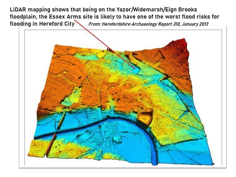
The LiDAR map (below) highlights the contours of the Yazor valley through Hereford, with the darkest blue, the Essex Arms Site, being the lowest lying land
Surface geological maps that include the distribution of alluvium give us clues to past watercourses. In the last Ice Age, the river Wye was blocked by ice and diverted to cut Breinton Gorge on the route the river Wye still takes today. This resulted in the Yazor Brook system becoming a minor brooks system on a very wide floodplain. It is likely that the peat identified in central Hereford as part of “Britain’s waterlogged heritage” has its origins in a preglacial period.
Within the complex glacio-fluvial deposits some water still flows underground and may appear at the surface in wet periods. Groundwater does not flow in straight lines, and the paths it takes and the obstacles to its flow may not be obvious from the surface. This means that the Yazor Brooks system is complex and may not always flow as simple surface flow models would predict.
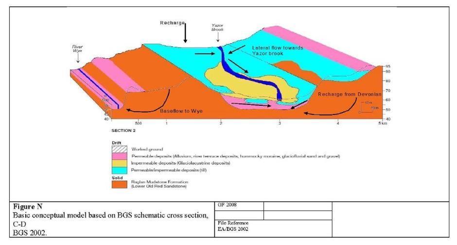
In the Yazor Brook valley there is an important aquifer within permeable deposits, below a more impermeable silty-clay layer (drift spread in and after the last Ice Age), all on top of an even deeper, underlying aquifer in the Raglan Mudstone Formation (solid). If the conjunction between a confined aquifer and its confining layer allow, groundwater may sometimes flow up hill. See more details here of how flows in aquifers may behave.
Under the conditions of this geological and glacial history, springs may not always arise in expected locations. The impermeable layers are not consistent in their thickness, so in some locations, springs break through from the groundwater in the valley bottom. Some flows have changed over time, as shown by comparing historic maps.
There is a Groundwater Source Protection Zone centered under the Kings Acre area of Hereford. The supply of pure groundwater in the aquifers has been an important reason for food and drink production industries to locate to Hereford, for example, Bulmers/Heineken In 2014 there were at least ten boreholes with water abstraction licenses around Hereford.
A graph of groundwater levels at Widemarsh Common going back to 1975 can be found here The fluctuations can be quite extreme.
Changes to the channels of brooks through Hereford over time, and the heritage therein
Flow of the Yazor brooks originally followed the contours, but in Saxon times part of Yazor Brook was diverted down a channel to feed a defensive Hereford City Ditch. Today the channel that once fed the City Ditch still flows in wet weather, partly underground, to reach the River Wye on the west side of Hereford.
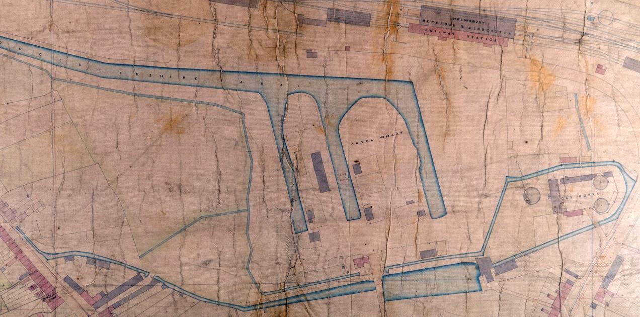
Part of Curley’s 1855 map of Hereford, showing the canal basin on the E side of the Essex Arms site
The Widemarsh and Tan Brooks had been diverted for mills and industries. The filled-in canal basin will still be influencing drainage of the Essex Arms site today. The Essex Arms site appears never to have been built on
In 1856 the waterworks were built at Broomy Hill, followed by a network of sewers which took pressure off the natural drainage through the city. In consequence, watercourses were subject to various diversions, both above and below ground. As industry within the city had less use for water from the brooks, some channels were filled in. West of Widemarsh, a splitter weir installed around 1960 made Widemarsh Brook the main channel, with the ‘Yazor Brook’ (aka City Leat) now only flowing when levels are high enough. This means that almost all the volume of the Yazor catchment now flows through the Essex Arms site Ayles Brook, an important tributary of the Yazor, also adds to a greater volume of water to this area in wet times; its confluence with Widemarsh Brook is at the junction of Widemarsh St. and Newtown Rd.
After flowing through the Essex Arms site, the entirety of Widemarsh Brook is channeled into a culvert under Jewson’s yard and Morrisons, reappearing as Eign Brook by Kentucky Fried Chicken and Hereford Hospital.
See more maps following the history of the brooks here A series of old maps of Hereford georeferenced to maps of today can be viewed here
Pollution and Water Quality
The River Wye is a Special Area of Conservation (SAC) and Site of Special Scientific Interest (SSSI), so water quality in its tributaries matters. Friends of the River Wye Citizen Science Project volunteers regularly report higher phosphate levels than the target limit of 0.1ppm. At site U030 at Merton Meadows, phosphate levels have reached as high as 1.39ppm (Hanna meter) on occasion. The Yazor Brook is one of the top three dirtiest watercourses in the Wye Catchment. For further monitoring of Yazor Brooks click here
A Watershed Pollution map shows that Welsh Water have several Combined Sewer Overflow outfalls into the Yazor in Hereford, including at Moor Park, Yazor Road and Penhaligon Way. See map here
A map (with photos) of about 30 visible outfalls into Yazor Brook within Hereford City (from HYBRP volunteers) is here. All outfalls may contribute to flood risk in times of high rainfall, as well as to pollution.
There are also Consented Discharge Points into Widemarsh Brook, from AVARA chicken processing and Heineken. These have strict controls on air and water emissions, but nevertheless our Yazor Brook project monitoring team has twice encountered - and reported, sewage fungus in the brook nearby.
Dairy and slurry pollution has also been recognized as a problem in the catchment. It was addressed partly by the Yazor being designated a Nitrate Vulnerable Zone in 2020 and again in 2024. However nitrate levels continue to be higher than acceptable.
Threats to biodiversity
Urban areas play an increasingly important role in providing habitat to support biodiversity. Herefordshire Council has policies which support this aims (as referenced above).
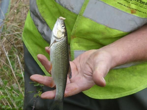
The Brooks system through Hereford provides many opportunities for wildlife refuges in an urban setting, including the Essex Arms Site. Kingfishers, 20 cm long chub, egrets, sparrowhawks, buzzards, otters, and even an eel, are among the many examples of wildlife recently sighted. Great crested newts are common locally, so it is likely that they inhabit the Essex Arms Site too.
The Wildlife Trust’s HYBRP volunteers also monitor the populations of invertebrate larvae at set points along the brook - click here, and log the data with the national Riverfly Partnership database.
A highly detailed and informative report on biodiversity within the Hereford part of the Yazor catchment forms part of an Ecological Impact Assessment attached to a Heineken planning application for a water treatment plant, P180789/N in October 2017.
Opportunities for Nature Based Solutions within the development of the Hereford City Masterplan for housing
Both Merton Meadows and Essex Arms sites are zoned for housing in the Hereford City Masterplan However, we would argue that nature-based solutions, using a ‘sponge city’ approach, would be more effective and cheaper on these sites than the traditional approach of hard technical solutions of pipes, culverts and canalizing Technical solutions such as these often hide such problems, likely to exacerbated by increasing climate change, leaving it for future generations to deal with
In 2023 we developed a Yazor Brook Strategic Development Plan, which outlines in more depth our ambitions to reduce flooding risk, decrease pollution, increase biodiversity, improve connectivity, enhance natural beauty, protect natural heritage,
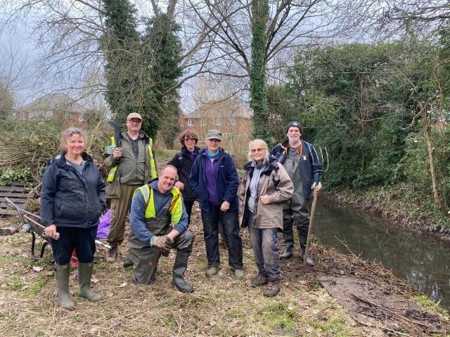
Chub caught at EAS, and HYBRP volunteers working on brook restoration (A Cottringer)
and improve wellbeing. We outlined how a wetland park at the Essex Arms site would fulfill these ambitions and provide the best solution for that site because:
• it floods frequently to a significant depth,
• the wildlife already there includes protected species
• it is potentially a highly effective filter for urban pollution
https://www.herefordshirewt.org/news/wetland-reserve-proposal-hereford-city
The ‘Sponge City’ approach is designed to mimic natural processes, allowing urban areas to absorb, store, and purify rainwater, much like a sponge soaks up water, slowing down the flow of rainwater and gradually releasing it back into rivers and streams. This slow-release system can effectively reduce the risks arising from flooding, reduce pollution through reed bed filtration, while simultaneously supporting urban biodiversity and public health through the creation of nature-enhancing green infrastructure. How wetlands improve wellbeing is outlined here.
This approach is being used successfully in places such as Slough, West Gorton in Manchester, Enfield, and Herne Hill.
Background Information on Hereford Yazor Brook Restoration Project
In the summer of 2019, we led a group of citizen science surveyors to map sites with opportunities for improving green infrastructure in their localities across Hereford City. These sites included the “blue/green corridors” along the city brooks. The sites were collated into a Community Green Infrastructure Map (CGIM) that has been shared widely, including with Herefordshire Council.
Authors of this fact file:
Dr Nicky Geeson
Anne Cottringer
Mo Burns
Nic Howes
Emil Morfett
December, 2024.
This report has drawn upon the observations and analysis from Hereford Yazor Brooks Restoration Project's wide range of volunteers and partners including:
Acer Tree Services
Andy Tatchell (focus on heritage in terms of mills)
Avara
Balfour Beatty Living Places
Bugs and Beasties
David Lovelace (focus on digital mapping)
Heineken
Hereford Allotments and Leisure Gardeners Association
Hereford City Council
Hereford City Tree Wardens (part of Herefordshire Tree Warden Network)
Hereford Sixth Form College
Herefordshire Community Recycling and Reuse Group
Herefordshire Council
Herefordshire Wildlife Trust
Modular River Survey
Riverfly Partnership
The Environment Agency
Welsh Water/Dwr Cymru
Wye and Usk Foundation