

MAITLAND DOWNTOWN MASTER PLAN
ADOPTED July 24, 2017

Aerial view of Downtown Core (2015)
EXECUTIVE SUMMARY
This document updates the 2003 Plan. The plan lays out a vision for a downtown that is a strong heart for the city and is economically competitive and socially relevant for today’s world. The focus of the current process is to clarify the Vision; update and revise the Downtown Maitland Revitalization/Master Plan, and expand it to include Maitland Avenue (from Maitland Boulevard to Orlando Avenue) as well as the Cultural Corridor.
The plan is a roadmap for change over time. It seeks to respond to the changed economic environment and the evolving demographic and market conditions in the community while ensuring that incremental moves occur within
a larger framework and are aligned with a future vision of downtown that was developed by the community. This framework is made up of a VISION, supported by six GUIDING PRINCIPLES, and implemented initially through five DEVELOPMENT FRAMEWORKS
The VISION describes the downtown of the future. It is intended to be aspirational and broad, setting course for the future. The GUIDING PRINCIPLES describe the future goals for downtown in broad principles. As time goes on, these principles are intended to remain constant, providing a baseline for new frameworks to be developed and the Master Plan to evolve to meet changing conditions.
Maitland Downtown Master Plan
INPUT
The DEVELOPMENT FRAMEWORKS outline the key actions for the City to take to execute the plan. They have been created in thoughtful consultation with community stakeholders, but they represent one of potentially many solutions consistent with the guiding principles. The plans and imagery shown with the frameworks are intended to be indicative of the character and intent of the recommended actions. ACTIONS are individual projects that are described in the frameworks and will still require further detailed design as part of the typical project development process.
VISION
VISION
A downtown that is a strong heart for the city and is economically competitive and socially relevant for today’s world.
GUIDING PRINCIPLES DEVELOPMENT FRAMEWORKS
GUIDING PRINCIPLES
What we learned during our consultation meetings Pillars of the Vision for Downtown Maitland
DESIRE FOR A DOWNTOWN
Sense of downtown – place to go see and be seen – has eroded LACK OF A CLEAR IDENTITY
Diluted identity rather than focused TRANSPORTATION CHALLENGES
Driving through, parking, pedestrians CITY OF ARTS AND CULTURE
Appreciated, but underutilized assets for Downtown placemaking
NO PUBLIC ANCHOR
Way to generate activity throughout the day and seasons LIVABLE CONNECTIONS TO DOWNTOWN
Expanding the area within walkable and bikeable reach of neighborhoods
SCALE OF DEVELOPMENT
Important to balance scale with activity
A PLACE BUILT FOR PEDESTRIANS
ENVIRONMENT
A PLACE THAT EMBRACES THE ARTS SUPPORTED BY STRONG NEIGHBORHOODS
FRAMEWORKS
ACTIONS
ACTIONS
Big Moves to achieve the Vision Incremental Steps
BUILD A NEW SPINE FOR DOWNTOWN
LINK DOWNTOWN TO THE COMMUNITY
MAKE PEDESTRIANS A PRIORITY
CONNECT PUBLIC SPACES AND CULTURAL AMENITIES
CREATE A PARK-ONCE ENVIRONMENT
Districts
Station Corridor/Northern Corridor
• Maintain the streetscape requirements
• Keep buildings built up to the road, hide parking
• Limited expectations for mixed use
Downtown District
• Maintain streetscape requirements
• Keep buildings built up to the road, hide parking
• Emphasize mixed use
• New spine of Independence Lane from George Avenue to Maitland Avenue at Lake Lily
• Mid-block alleys to access parking/ back-of-house with up to one curb cut per block on each side of the street on Independence Lane
• Plan for two public/private parking locations (Horatio/Maitland Ave, Ventris/Maitland Ave.)
• Potential cultural partner shared parking structure (with commercial liner space on the first floor facing Maitland Avenue) at Packwood Avenue and Maitland Avenue
• Cultural Corridor part of Downtown
• New park next to City Hall as an anchor near the northern end of spine
• Conduct space needs study for Library to determine if a need for a larger facility exists. If needed, consider potentially combining with Civic Center expansion.
Southern Corridor
• Keep streetscape requirements
• Keep buildings built up to the road, hide parking
• Limited expectations for mixed use
Maitland Avenue Corridor District
• Rules already allow development of retail – do not change.
• Potential to reduce lanes from 4 to 2, add on-street parking and cycle track as first phase road diet project. Evaluate more significant rebuild as redevelopment occurs.
• It may occur naturally over time, but this district is not highlighted or called out as a retail district so the focus can remain on developing Independence Lane. In the future, this district could develop into an alternative or boutique retail district. It currently has no retail uses.
Greenwood
Gardens Neighborhood
• Implement the Quality Neighborhood Program improvements.
• Do not change allowable density, zoning or land use.
Transportation
Regional Streets
• 17/92 – reduce speed limit, designate an “Urban Corridor”
Community Streets
• Maitland Aveune – Evaluate reduced speed limit, reduce to two lanes and add on-street parking from Jackson to Sandspur, add cycle track from Lake Lily Sandspur
• Horatio Avenue – Evaluate reduced speed limit, widen bike lanes, extend bike lanes to 17/92, signalize intersection with Swoope to allow eastbound left turn onto Horatio.
• Sybelia Parkway – Improved bike and pedestrian facilities
• Sandspur – Extended bike trail to connect to wider network
Local Streets
• Independence Lane – Streetscape with parallel parking, shared use with bikes, street trees
• Ventris, Packwood, George, etc. – add parallel on-street parking, improve pedestrian facilities with shade trees, connect sidewalks
• Improve Packwood streetscape and intersection with Maitland Avenue to facilitate pedestrian movement between Lake Sybelia and Independence Lane.
• Widen Sybelia Avenue to four lanes between Maitland Ave and 17/92 to allow more stacking and use of this route as alternate to Horatio.
Trails
• New trail from SunRail Station to Sybelia parallel to, but outside, the FDOT Railroad right-of-way with easements from property owners.
• New cycle track along east or west side of Maitland Avenue from Lake Lily to Sandspur
• Existing trail from Lake Lily to City Hall is moved over to Independence Lane to share the road
• Potential to extend current trail from Lake Avenue south to Winter Park (Ravaudage)
• Widened bike lanes on Horatio and extended to intersection with 17/92
Regulatory
• Expanded DMZD to include entire “Core Area” (Include properties on the east side of Maitland Avenue from Packwood to 17/92 for consistency across block.)
• Added Architectural Design Standards to Downtown Maitland Special District
• Address building massing
• Pedestrian scale and architectural elements on the first floor
• Maintained Cultural Corridor Regulations
• Maintained Maitland Avenue Special District Regulations


Streetscape , early Maitland Station, Park House hotel, Maitland Community Center, Stones Service Station, Welcome to Lake Maitland (All photos from 2003 Redevelopment Master Plan)

Clockwise from above: Maitland Avenue
LISTENING AND LEARNING
History
The story of Downtown Maitland has long been one of “passing through.” One of the oldest incorporated municipalities in Central Florida, the city has a long history. The area was once called Fumecheliga (Musk Mellon Place) by the Seminole Indians as they passed through between settlements. When Fort Maitland was established here in 1838 by the U.S. Army (named after Captain William Seton Maitland, a hero of the Seminole Wars), the only way of getting to Central Florida was by boat. The trip left Jacksonville and travelled down the St. Johns River to Fort Mellon (Sanford), then by horse or foot. Fort Maitland was a small fort built on the west shore of Lake Maitland as a rest stop between Fort Mellon and Fort Gatlin (Orlando). What is now Maitland Avenue was part of the Old Black Bear Trail which ran from Montreal, Canada to St. Petersburg, Florida, and passed by the fort.
The fort did not last long after the Indian wars. People found the area a good place to settle among the natural springs and extensive pine forests. As the Civil War wound down, more settlers came. They bought and cleared large tracts of land to plant citrus groves. Soon the city began to develop. The first deed for property in the city was written in 1873 to George H. Packwood who built a large hall for town meetings and social gatherings. Packwood Hall, since burned down, was located where the current City Hall parking lot is now located. There was a large hotel, Park House, built between Park Lake and Lake Catherine, which became a noted winter resort. Among many other notables, two presidents, Grover Cleveland and Chester Arthur, passed through the Park House.
As the first orange trees were coming into production, a syndicate of businessmen foresaw the need for improved transportation to aid shipment of the fruit to northern markets. In 1880, a railroad was completed from Jacksonville to Maitland, primarily to ship the burgeoning orange crop. For several years, Maitland had an ice factory, two livery stables, and to serve the citrus groves, a large packing house in the center of town. As many as 300,000 boxes of fruit were to be shipped each season. The city was incorporated as the Town of Lake Maitland in 1885. After two years of devastating, tree killing freezes in 1894 and 1895, many of the grove owners were so financially affected that they left Florida. The town survived, however, and wealthy visitors kept coming to enjoy the climate. The groves rebounded, and by 1926, production was higher than ever before.
In the 1950s the space age exploded and Martin Marietta Corporation, as we know it today, moved from Baltimore to Orlando. Families were moved down in contingents of two or three hundred at a time. Due to its ease of access to the plant, Maitland became a natural place for them to come. In 1959 a new city charter changed the name from Lake Maitland to Maitland.
With this growth in population, Maitland Avenue and Orlando Avenue (U.S. Highway 17-92) came alive with building construction. Supermarkets opened, as did restaurants, service stations, condominiums, garden apartments and churches. Much of the form of this new development was driven by the automobile, with easy parking a promotional
consideration for almost all users. The city continued this steady growth trend through the 70s and 80s, including the 226 acres of land developed into Maitland Center west of Interstate 4.
The city has maintained a strong residential identity, sustained by the beauty of the area, the diverse economy in the region, and the strong schools and civic institutions found in Maitland. By the mid 90s, however, Downtown was sagging. Increasing traffic on Orlando Avenue, as well as competition from other suburban locations, had left Downtown in need of redevelopment. The city led an effort to develop a Downtown Master Plan, as well as a Community Redevelopment Area (CRA). That plan, and the associated planning effort, bore fruit in the form of more urban standards for development along Orlando Avenue, improved public infrastructure, such as a master drainage system for a portion of Downtown, and several mixed-use infill developments.

Regional Location Study Area Definition
The City of Maitland is located in Orange County along the border of Seminole County. It is approximately five miles from downtown Orlando on Interstate 4, the major backbone of the regional transportation network in Central Florida. Maitland sits virtually at the geographic center of the region of more than two million residents and countless more millions of visitors. Downtown Maitland is situated along Orlando Avenue (US 17-92) and the Central Florida Rail Corridor.
Through its downtown planning efforts over the past two decades, the City of Maitland has shown its commitment to improving the social, cultural, and economic value of its community, and to realize the potential of its Downtown. The City has evolved from its original historic pattern and early homesteads on Lake Lily and Lake Catherine. Today, Maitland is a complex geographic place of diverse Neighborhoods, economically active Corridors, and emergent Centers of activity. This expanded geography is served by a community infrastructure of environment and parks, cultural institutions, public buildings and community services, utilities infrastructure, streets, and regional transportation.
In the last several years, Maitland has accelerated its efforts to discuss the character, vision, and future of Downtown. New civic buildings and streetscape projects, CRA redevelopment, the opening of a SunRail station, and US 17-92 planning are just a few projects that have signaled an evolution towards the future. If the past 20 years have been focused on community building in the downtown, much of the forward thinking discussion is about community enhancement, and in some places, community re-development
5 Miles 0 North
MILES
MILES
Maitland sits very nearly in the center of the Orlando Metro region.

2003 Master Plan
The Downtown Maitland Revitalization/Master Plan was created as a guide for the economic redevelopment of the commercial core of the city. The focus area of the Plan centers on the Orlando Avenue corridor, stretching North to South from Maitland Boulevard to the railroad bridge at the City’s southern boundary.) The plan’s vision is to create a vibrant downtown area that is commercially oriented, friendly to pedestrians and complimentary to the “Cultural Corridor” along nearby Maitland Avenue. A Master Plan for the Cultural Corridor was adopted in 1994. This Downtown Vision was realized through the collaboration of the residents of Maitland and the City. During the planning process, four working groups were established to address specific areas of concern including: Infrastructure, Character, Streetscapes, and Regulatory & Economic Incentives. Each group was charged with addressing issues impacting the aesthetic appeal and economic viability of the downtown corridor.
Following the adoption of the Downtown Maitland Master Plan in 1997, the City realized that the anticipated wave of redevelopment was slow in coming. As a result, in May 2003, the plan was revised to include the creation of a Community Redevelopment Agency (CRA) as authorized by Section 163.34 of the Florida Statues. The CRA is responsible for pursuing the goals and objectives outlined in the City’s Comprehensive Development Plan and Downtown Maitland Revitalization Plan. In addition to the creation of the CRA, the City contributed funds for preliminary engineering to help expedite the permitting process and reduce infrastructure costs.
Through these progressive actions, the City has demonstrated a firm commitment toward the revitalization of its core downtown area. Along with the master planning efforts associated with the Downtown Revitalization Plan, a full set of design guidelines and standards was developed for the corridor. These guidelines
include individual master plan concepts for each of three corridor subareas. Standards include specific design requirements regarding density, intensity (Floor Area Ratio), parking location and stormwater management, among others. Visual examples of appropriate streetscape features and architectural detailing are also included in addition to a list of permitted, conditional, and prohibited uses. The Revitalization Plan also contains a detailed discussion of infrastructure improvement needs throughout downtown. Information relating to utilities, potable water, sanitary sewer, stormwater, and transportation improvements are all explored in the plan accompanied by detailed maps, and a discussion of funding mechanisms. In the 12 years since its adoption, some of this plan has come to fruition and some elements have not occurred. The deep recession that began shortly after this plan was last updated brought development to a standstill and changed the market dramatically.

Cover images from 2003 Downtown Maitland Revitalization Plan
2003 Downtown Maitland Revitalization Plan: Illustrative Master Plan
Community Redevelopment Agency
A Community Redevelopment Agency (CRA) is a dependent district established by City government for the purpose of carrying out redevelopment activities that include reducing or eliminating blight, improving the economic health of an area, and encouraging public and private investments in a CRA district. The CRA is governed by State Statutes, Chapter 163, Part III. The Maitland Community Redevelopment Agency is funded through Tax Increment Financing (TIF). The funds are collected as property values increase and a portion equal to that increase is captured by the Agency. TIF raises revenue for redevelopment efforts without raising taxes. CRA’s have been used by many cities in Florida to revitalize urban areas. Other city examples include Orlando, Winter Park, Delray Beach and Sarasota. An important part of creating a CRA is the preparation and adoption of a CRA Redevelopment Plan, which sets forth the programs for improvement for the redevelopment area.
2017 Downtown Master Plan
The Maitland Downtown Master Plan encompasses multiple zoning districts (Downtown Maitland Zoning District (DMZD), Maitland Avenue Special District, and the Cultural Corridor Zoning District) and creates a unified vision and plan for the development, growth and interplay of these districts that comprise the downtown Maitland area. The Master Plan illustrates the vision and outlines certain steps that need to be taken and principles that need to be followed to achieve the vision.
The largest zoning district (DMZD) within the Master Planning area is also designated as the CRA. The CRA is required by State Statute to have a redevelopment plan which spells out actions to be taken to redevelop the designated area. Funds from the CRA can only be spent on items delineated in the mandated plan. This CRA Redevelopment Plan is call the Downtown Maitland Redevelopment Plan. It is a comprehensive work plan that includes not only capital improvements spelled out in the
overarching Master Plan, but also projects and activities such as marketing, special events, beautification, stakeholder involvement, etc. These ongoing activities, projects and initiatives of the Downtown Maitland Redevelopment Plan lead to the fulfillment of the broader Maitland Downtown Master Plan.
MAITLANDBLVD


Land Use and Built Form
The spine of Downtown Maitland is Orlando Avenue (US 17-92). It presents high-speed traffic in an environment that should be low-speed. It is minimally landscaped (although incremental efforts by the City have made improvements when redevelopment projects have occurred) where an abundance of street trees should line the corridor. It rewards long trips (as a significant regional corridor, it is for people who have no origin or destination in Maitland, who aren’t living or shopping here) rather than supporting a compact environment. All of these elements need to be addressed in order to improve the viability of Downtown as a walkable, mixed-use place. Land uses along this corridor are generally commercial and office, with areas of apartments and condominiums near Lake Maitland.
Maitland Avenue from 17-92 to Maitland Boulevard is an important street in the fabric of everyday life in the City. Anchored by the Jewish Community Center on the north to Lake Lily on the south, this artery is critical to a wide array of institutions, businesses and residents of the community. It is a critical access corridor for the Downtown. The master plan will take a fresh look at the corridor to understand its role today and what options exist for its future, whether it remain as is or is put on a road ‘diet.’
The Downtown is edged by neighborhoods on virtually all sides. This edge is generally stable and well-defined. As one may expect with a Downtown environment. there are a significant number of public and institutional uses, such as municipal buildings, cultural facilities, churches, and schools. The variety of buildings and public spaces are shown in the photos on the next page.
EXISTING LAND USE LEGEND
[ ] Residential Vacant
[ ] Residential Single Family
[ ] Residential Condo
[ ] Residential Multi-Family
[ ] Commercial Vacant
[ ] Commercial Retail / Services / Entertainment
[ ] Commercial Auto Related
[ ] Office
[ ] Industrial Vacant
[ ] Industrial and Warehousing
[ ] Transport, Communications, and Utilities
[ ] Institutional Vacant
[ ] Institutional
[ ] School
[ ] Parks
[ ] Open Space / Drainage
[ ] Ag Pasture / Timber / Crops / Groves
[ ] Vacant Non-Ag
HORATIO


Demographics
Maitland has an estimated population of 17,500. Due to its employment concentration, particularly in Maitland Center, the city has an estimated daytime population of 42,000. The city is growing faster than nearby suburban towns, and is projected to continue this growth trajectory with 10.2% projected growth over the next five years.
The city’s median household income is among the highest in the region, and is greater than nearby Winter Park and Altamonte Springs. The Branding and Marketing Strategy, prepared by Arnett/Muldrow & Associates and included as an appendix to this plan, identified demographic characteristics of the city’s population.
Life stage, defined by a family’s age and presence of children, of the Maitland population skews predominantly older, as empty nesters and retirees make up 59% of households in Maitland. A healthy portion of the city is younger with no children (29%). A relatively small segment of the population are families with kids. This reflects a shift from Maitland’s classic profile as a family community where people move for strong schools and institutions, as children left home while parents remain entrenched in their neighborhoods.


Residents discuss “Best of” , “Worst of” and Opportunities for Downtown Maitland.
Detailed descriptions of resident concerns and issues allowed the planning team to develop guiding principles for the plan.
Process
The master plan was developed through an Interactive public engagement process. The planning team engaged public thought and feedback in a variety of ways. The project began with a public kickoff meeting, where participants identified the “best of” and “worst of” Downtown Maitland on a map together with areas of opportunities and priorities. The participants also answered a questionairre regarding their vision for Downtown.
To gain focused input, the CRA organized a series of stakeholder interviews where the design team could have small group discussions with business owners, residents, elected and appointed officials, city staff, and neighborhood leadership from areas outside of downtown.
The insights from these meetings led to a series of insights and frameworks for creating a new Downtown vision. These were shared with the public and refined during a strategic direction meeting. Participants at this meeting also validated the guiding principles for the vision and discuss development frameworks, including a lengthy discussion on Greenwood Gardens.
The plan was developed during a 3-day charrette held at City Hall. The charrette included a “drop-in” session where interested members of the public could interact with the planning team and help refine the plan in “real time”. The charrette also included a steering committee review session, and concluded with a work-in-progress presentation where additional comments were solicited.


Residents and planning team members discuss previous plans for improvements in Greenwood Gardens neighborhood.
Project Manager Blake Drury gives Work-in-Progress presentation at close of charrette.
Members of the public review draft master plans during Work-in-Progress presentation at close of charrette.
THESE INSIGHTS, THOUGH NOT ALWAYS NEW INFORMATION, WHEN SEEN FROM DIFFERENT PERSPECTIVES AND GROUPED WITH OTHER INSIGHTS, CAN LEAD TO NEW OPPORTUNITIES FOR ACTION, DESCRIBED IN THE LATER SECTIONS OF THE PLAN.
INSIGHTS
Based on analysis of the physical environment, economic and demographic metrics, and discussion and feedback sessions with the community, these insights have come to the foreground as the team’s interpretation of important issues that will help to address the challenge of growing Downtown Maitland into a thriving center for the community. These insights, though not always new information, when seen from different perspectives and grouped with other insights, can lead to new opportunities for action, described in the later sections of the plan.

LACK OF A CLEAR IDENTITY
Despite previous efforts at redevelopment, there is no clear identity for Downtown Maitland. Because there is no clear identity, Downtown struggles with its direction. The geography identified as Downtown is long and linear, diluting the identity rather than focusing it.
DESIRE FOR A DOWNTOWN
There is a strong desire in the community to have something special that’s better than what they have today. The sense of Downtown, as a place to go and to be seen has been eroded over the years to the point where it exists more in people’s minds than on the ground. The community wants to see the town progress and grow, but doesn’t want to be alienated in the process.
TRANSPORTATION CHALLENGES
The current transportation situation is challenging for everyone. This includes driving through downtown east and west and past downtown north and south, accessing areas from 17-92, as well as the perception of parking availability in the future.
LIVABLE CONNECTIONS TO DOWNTOWN
There is a strong desire for infrastructure that improves the pedestrian and bicycle environment in downtown and expands the area within walkable and bikeable reach of downtown.

CITY OF ARTS AND CULTURE
Maitland has a thriving arts community, anchored in many respects at the Art & History Museums - Maitland. The cultural belt (Fort Maitland Park, Lake Lily Park, Civic Center, Library, Senior Center, Quinn Strong Park, Art & History Museums - Maitland, Lake Sybelia Park) is an appreciated, but underutilized, asset.
NO PUBLIC ANCHOR
While downtown Maitland enjoys a variety of diverse anchor destinations, such as Lake Lily Park, Art & History Museums - Maitland, City Hall, and Maitland City Center, downtown lacks an anchor public space along Independence Lane to attract people. Other cities have these types of spaces along their “Main Street” that serve as anchors and generate activity throughout the year, even when the stores are closed - Downtown Maitland does not.
SCALE OF DEVELOPMENT
The scale of development is important to residents – there is a sense that more large scale development may hamper quality of life. Low Impact Development (LID) that incorporates “green” stormwater solutions for all future development is a goal of the community.
GUIDING PRINCIPLES


Downtown is a place that is built to deliver experiences.
In a time when it’s possible to shop on your phone and get items delivered almost instantly, the downtown of the future will be a place that is built on face to face experiences. In Maitland, this means that downtown should focus on delivering leisure, arts, and culture experiences first. Other uses will naturally follow people drawn to these experiences.
Downtown is a neighborhood of choice.
There will be people who are drawn to live downtown near the great experiences and higher level of activity. This should be accommodated through higher density housing in the core. Others will choose to live in one of Maitland’s other strong neighborhoods. Those who make this choice should be served with safe and livable bicycle and pedestrians connections to downtown.
Downtown is a place with a strong link to the natural environment.
Downtown Maitland is fortunate to have Lake Lily, Lake Sybelia, and Lake Maitland all within close proximity. People are drawn to the lake edge, and this space should be linked to the greater downtown for ease of access. At the same time, development in the core should utilize the best thinking on low-impact stormwater design to make sure that these assets continue to shine.
THESE PRINCIPLES GUIDE THE MASTER PLAN. THEY ARE THE UMBRELLA UNDER WHICH THE FRAMEWORKS AND SPECIFIC VISION CONCEPTS HAVE BEEN DEVELOPED. AS TIME GOES ON, THESE PRINCIPLES ARE INTENDED TO REMAIN CONSTANT, PROVIDING A BASELINE FOR NEW FRAMEWORKS TO BE DEVELOPED AND THE MASTER PLAN TO EVOLVE TO MEET CHANGING CONDITIONS..
Downtown is a place that is built for pedestrians.
Downtown life happens on foot. The vision for the core is one of pedestrian priority - cars must move at a speed and temperament of pedestrians. For new development, this means that active streetfronts are required where pedestrians will be present, particularly on the Independence Lane spine and on the crossing pedestrian priority streets that link other destinations to the spine.
Downtown is a place that embraces the arts.
Maitland has a long tradition of supporting the arts going back to the early 20th century artists’ colony and continuing today through the Art & History Museums - Maitland, an Historic Landmark listed on the National Register of Historic Places. This is a differentiating factor for Downtown, and one that should be visible and evident in Downtown, from public art to wayfinding to activities.
Downtown is a place that is supported by neighborhoods.strong
If Downtown is strong, the surrounding neighborhoods will be strong. A focus on Downtown development cannot lose track of the neighborhoods that it serves.


DEVELOPMENT FRAMEWORKS
THESE DEVELOPMENT FRAMEWORKS OUTLINE THE KEY ACTIONS FOR THE CITY AND COMMUNITY TO TAKE TO EXECUTE THE PLAN. THEY HAVE BEEN CREATED IN CONSULTATION WITH COMMUNITY STAKEHOLDERS, AND REPRESENT ONE OF POTENTIALLY MANY SOLUTIONS CONSISTENT WITH THE GUIDING PRINCIPLES. THE PLANS AND IMAGERY SHOWN WITH THE FRAMEWORKS ARE INTENDED TO BE INDICATIVE OF THE CHARACTER AND INTENT OF THE RECOMMENDED ACTIONS.

[1] BUILD A NEW SPINE FOR DOWNTOWN Independence Lane, anchored on the south by Lake Lily and the north by the new Independence Square, is envisioned as the pedestrian-oriented main street for the district.

[2] LINK DOWNTOWN TO THE COMMUNITY
All local streets in downtown give priority to pedestrians and bikes. Community streets link neighborhoods to downtown with a “complete streets” approach, and regional streets come through on urban terms.

[3] MAKE PEDESTRIANS A PRIORITY
Safety and comfort on foot is the hallmark of a great downtown, so upgrades to streetscapes, sidewalks, and bike facilities link destinations within and outside the core in a safe, functional, and comfortable manner.

[4] CONNECT PUBLIC SPACES AND CULTURAL AMENITIES
Key cultural destinations need to be connected to the core to drive visitors to repeat trips and to support downtown as a place for leisure and culture.

[5] CREATE A “PARK ONCE” ENVIRONMENT
Vehicular access to the core is necessary, but once there, visitors should be able to walk safely and comfortably to all of their destinations.
A Potential Concept of Development

Build a New Spine for Downtown 1
Independence Lane, anchored on the south by Lake Lily and the north by the new City Square, is becoming the pedestrian-oriented main street for the district. City Hall and Maitland City Centre have begun to form the edges of this space, and the street will be built through site redevelopments and eventually provide a full street connection from George Street on the north to Maitland Avenue and Lake Lily on the south.
The diagram at left shows the key building frontages created by the new street. This smaller block structure creates a walkable core for downtown. Primary frontages should be edged by buildings with active commercial space and entrances to upper floor uses and not broken by driveways. The mix of first floor uses fronting Independence Lane is critical and should be composed of at least 80% restaurant/retail uses. Office, personal and professional services, non-profit and other non-retail uses should be restricted or prohibited.
Secondary frontages should be edged by buildings where development program allows. Where buildings are not possible, a knee wall and landscape is sufficient to maintain spatial enclosure of the street space. Access to loading, parking, and service areas should come only from functional alleys as shown on the diagram.
Buildings along the spine should be at least three stories in height and massed to appear as a series of individual buildings composing a traditional “Main Street” streetscape. Care should be taken to provide building relief at intervals consistent with typical storefronts.


Artist’s vision of new Independence Lane corridor looking north toward City Hall.


LAKE LILY
Lake Lily should remain a focus of passive recreation. Adjacent to the park, there exists an opportunity for a renewed Venue. The city should support the efforts of the Venue to move forward with their vision for a reception and performance location at this key spot. This may include a partnership to share space with the library.
Whatever use is developed on the site, its scale next to the lake is important. It should be no more than three stories high and should give a lower-scale face respecting Maitland Avenue. There is potential for some or all of this space to be shared; development could have shared garage or could be served by a garage east of Maitland Avenue as part of the park-once environment envisioned by the plan.
ORLANDO AVENUE FRONTAGE
The vignettes at left show two different concepts for building scale along Orlando Avenue. Each concept fronts primary edges along Independence Lane. The lower amount of building intensity in the lower block scenario incorporates surface parking while still allowing the edge along Orlando Avenue to be held with a building.
The top block scenario includes more building density, comparable to Maitland City Center. This level of program requires an internal garage, which allows secondary frontages to be held with buildings. The development still provides service on service streets. Garage facades are located on secondary frontages and service drives only. When located on secondary frontages, garages should be articulated like a building. It is anticipated that each site, south of Packwood Avenue, would handle its own stormwater on-site through vaults.
Example of lower and higher intensity development blocks between Independence Lane and Orlando Avenue.
Aerial view of potential changes to Venue on the Lake at edge of Lake Lily.
Lake Lily
Quinn Strong Park
SunRailCorridor Venue on the Lake Library
Link Downtown to the Community 2
Streets play a key role in the form, function, and aesthetics of a downtown. Streets are the means of travel, allowing children to get to school and their parents to get to work. Streets create places for exchange, bringing together neighbors and drawing customers to downtown shops, offices, and parks. Streets are also a significant portion of the public space in a downtown, establishing the image of the downtown in ways both overt and subtle.
The cornerstone transportation strategy for Downtown Maitland is a move to “complete” the streets downtown through design and operational strategies that lead to streets that are safer, more accessible, and easier to use for everyone. By doing this, the outcome should be a better community for people to live, play, work, shop, and visit.
WHAT IS A COMPLETE STREET?
A Complete Streets philosophy holds that streets should be designed to serve a broad range of users – both young and old, on foot or on bicycle, in a car or in a bus – rather than being designed primarily for cars and trucks as though nothing else matters. The National Complete Streets Coalition defines a Complete Street as:
“Complete Streets are streets for everyone. They are designed and operated to enable safe access for all users. Pedestrians, bicyclists, motorists, and public transportation users of all ages and abilities are able to safely move along and across a complete street. Complete Streets make it easy to cross the street, walk to shops, and bicycle to work. They allow buses to run on time and make it safe for people to walk to and from train stations.”

Complete Streets should not be viewed as ‘special projects,’ only applicable in unique cases and requiring significant amounts of extra planning, funding, and effort. A complete streets approach for downtown should view each transportation improvement to a roadway as an opportunity to create safer, more accessible streets for all users, including pedestrians, cyclists, and public transportation passengers.
COMPLETE STREET FRAMEWORK
The framework for transportation in the Downtown Core places each type of roadway in its proper relationship to surrounding land uses. Roadways should be designed based on their full function rather than just the needs of cars and trucks. A broad range of users must be considered, including:
Moving Users
• Cars
• Buses
• Trucks
• Bikes
• Pedestrians
Static Users
• Shops
• Offices
• Businesses
• Residences
Example of “Complete Street” components serving users beyond cars and trucks, such as bikes and peds, and on-street parking for businesses.
MAITLANDBLVD

REGIONAL STREETS IN DOWNTOWN MAITLAND ARE DESIGNED AS TRULY URBAN THOROUGHFARES. THEY FEATURE SHORT BLOCKS, ENABLE ACCESS TO THE LOCAL STREET NETWORK FOR TRIPS WITH LOCAL DESTINATIONS, AND REINFORCE SLOW SPEED OPERATION [35MPH NOT 45MPH].
REGIONAL STREETS
Orlando Avenue and Maitland Boulevard serve drivers with destinations and/or origins outside of Downtown. Their design and management is largely focused on traffic throughput, with less concern on the impact of this traffic’s speed and driver behavior on the urban environment being created in Downtown Maitland. The framework idea for Regional Streets is to bring traffic through on the terms of Downtown’s urban condition. Block structures should be small, with short blocks.
The City has done much to improve the urban transportation condition in downtown. Sybelia has been connected to Swoope at Horatio, giving an option to the Horatio corridor through the heart of the core. However, the inability to turn east at Horatio from southbound Sybelia negates the effectiveness of the new block structure delivered through redevelopment in the name of a suburban block length standard. This improvement should be considered a transportation priority for downtown and a signal warrant study is recommended to begin that process.
MAITLAND AVE
CONCEPTUAL STREET FRAMEWORK [ ] Regional Street [ ] Community Street [ ] Local Street

COMMUNITY STREETS IN DOWNTOWN MAITLAND ARE COMPLETE STREETS. THEY SUPPORT VEHICULAR, BIKE, AND PEDESTRIAN CONNECTIVITY, ACCESS TO THE LOCAL STREET NETWORK, AND REINFORCE SLOW SPEED OPERATION [25MPH NOT 35MPH] THROUGH STREETSCAPE IMPROVEMENTS AND ON-STREET PARKING WHERE APPROPRIATE.
COMMUNITY STREETS
Horatio and Maitland Avenue, along with Sybelia, are the major community streets in the Downtown Core. Their purpose should be to connect downtown to the neighborhoods in as complete a fashion as possible. This may entail bike or pedestrian retrofits on these streets, and may suggest management at a slower operating speed safer for all users.
LOCAL STREETS
Local streets in the Downtown Core should prioritize pedestrian and bike travel. Vehicular speeds should be low, and retrofits to support pedestrians, such as improved sidewalks, streetscapes, and street trees, should be encouraged throughout downtown.
LIBRARY VENUE on the LAKE QUINN STRONG PARK
LAKE LILY
LAKE
MAITLAND
Make Pedestrians a Priority 3
Downtown streets should be treated as multifaceted civic spaces shared among many different types of users, and serving many different functions. These streets should also accommodate many types of users, including pedestrians (including children, the elderly, and the disabled), bicycles, scooters, transit, automobiles, services trucks (delivery, garbage pickup, moving vans, etc..), and emergency vehicles. Downtown streets and parkways also must serve many functions, like access to private property, connections between land uses, transportation, connection to the open space network, community structure, identity, and pride, utilities, stormwater management, landscaping, and fostering social interaction and frequent community events.
Walking should be recognized as the fundamental mode of transportation within the Downtown Core. This recognition will lead to the most efficient multimodal transportation system, and it requires an integrated approach to land use, transportation planning, and urban design. To promote pedestrian trips, streets must be designed foremost for pedestrians with shade, ample sidewalks, cross walks, interesting things to see, meaningful destinations, and protection from automobiles. Streets must also offer the most direct route options among all locations and should be designed to keep automobile traffic slow and drivers alert to their surroundings.

CROSSING 17-92
In order to reduce the barrier effect of 17-92, the City should work with FDOT to ensure that the maximum effort is given to accommodate pedestrian crossing of the roadway. This could include physical changes such as additional crosswalks between intersections on long blocks, speed reductions on 17-92, added refuge islands, and operational signal changes such as leading or lagging pedestrian phases.
Grade-separated crossings (pedestrian bridges or tunnels) are generally inconsistent with the type of street-front urban environment envisoned for downtown. The space necessary for ramps has an impact on the adjacent urban fabric, their disconnection from nearby uses causes concern from a crime-prevention perspective, and the need to separate pedestrians from cars signals a second-class status for pedestrians.
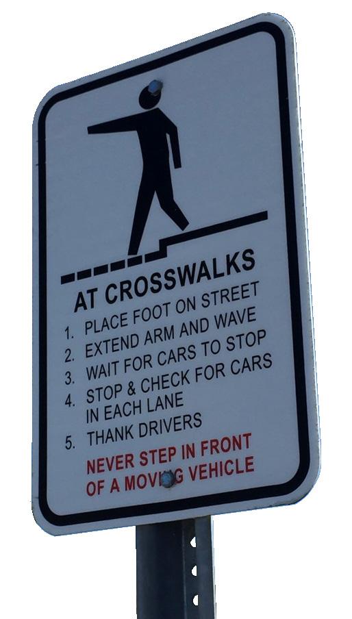
The pedestrian environment in downtown needs to change so that signs like this one are no longer necessary
MAITLAND AVENUE
Maitland Avenue from 17-92 to Maitland Boulevard is an important street in the fabric of everyday life in the City. Anchored by the Jewish Community Center on the north to Lake Lily on the south, this artery is critical to a wide array of institutions, businesses and residents of the community. It is a critical access corridor for the Downtown. An initial comparison of its traffic volume to its capacity seems to indicate that one travel lane in each direction could be converted to another use. Pending a more detailed study, this conversion could happen from Sandspur to the south through the Downtown Core. Given the location of the street, it is a candidate to include both on-street parking to serve a growing street-front pedestrian environment as well as a separated bicycle facility to connect northern neighborhoods to Downtown. Any detailed study should understand the street’s role today and what options exist for its future, whether it remain as is or is put on a road ‘diet.’ In the event it is a candidate for narrowing and reallocation of lanes, two potential solutions are shown on the following pages.

Existing Maitland Avenue cross-section looking south. Generally, uses on the east side of the street feature parking to the back or side of the building, while overhead utilities are located on the west side of the street.
East West

INTERIM “LOW BUILD” SECTION
The section above presents a “road diet” option for Maitland Avenue south of Sandspur. This option would maintain the existing curb lines and medians (with turn lanes). Onstreet parking could be provided on the east side of the street, with enhanced pedestrian improvements such as lighting and street trees, including the addition of street trees in “bump outs” to visually narrow the roadway cross section. A cycle track, similar to Tampa’s “Green Spine” (shown in the image to the right) could be aligned on the west side of the street to provide improved bicycle connectivity to the Downtown Core.

East West


REDEVELOPED SECTION
The section above presents a more involved “road diet” option for Maitland Avenue south of Sandspur. This option entails a full rebuild of the street as one lane in each direction with a center turn lane. The back of curb areas are dedicated to additional sidewalk areas for pedestrian and bike circulation and amenity areas or seating for new development that fronts the street. On-street parking could be provided in each block, along with enhanced pedestrian improvements such as lighting and street trees, including the addition of street trees in “bump outs” to visually narrow the roadway cross section. A multi-use trail, similar to Indianapolis’ “Cultural Trail” (shown in the image to the left) could be aligned on the west side of the street to provide improved bicycle connectivity to the Downtown Core while still allowing for streetfront uses.

CONNECTED PUBLIC SPACE NETWORK
[ ] New Main Street
[ ] Complete Street Corridor
[ ] Pedestrian Connector Street
[ ] Cultural Connector
[ ] Off-Street Multi-Use Trail
[ ] Enhanced Bike Connector
[ ] Key 17-92 Intersection
HORATIO
SYBELIA
Connect Public Spaces and Cultural Amenities
In the past, downtown ended at Maitland Avenue due to the barrier effect of the street. The connection between Lake Sybelia on the west and the core of downtown should be improved to allow these institutions to be part of downtown, not perceived as located on periphery of downtown.
A parking garage on the city-owned property on Packwood, together with gallery space or retail uses on the Maitland Avenue frontage, would allow for a more direct physical and visual connection of the uses. This garage could be done in partnership with the Art & History Museums to provide parking capacity for that use as well as other proximate uses within downtown. This and other partnerships should be evaluated as planning for the garage is advanced.


Above: View of potential connecting streetscape improvements; Below & Left: Examples of public art integrated with parking garages.
Lake Sybelia
Quinn Strong Park
City Hall
City Square
MaitlandAvenue
PackwoodAvenue
IndependenceLane
Art & History Center
INDEPENDENCE SQUARE
North of City Hall, on the former City Hall site, a new park is proposed. Called Independence Square, it is intended to anchor the north end of the Downtown Core and bring activity to this portion of downtown, giving folks an additional reason to go downtown, even when the shops, restaurants or civic spaces are closed. The square should be a focus for events, but should also be designed to allow for daily use with activity areas, lunch-time gathering areas, etc.. that may be worked into a more structured urban setting.


Artist’s vision of new City Square looking from corner of Independence Lane and Horatio Avenue.
MAITLANDBLVD

Bicycle and Pedestrian Network
A robust network of bicycle and pedestrian facilities is envisioned to connect downtown to internal and external destinations. The network is composed of four key elements.
[1] SUNRAIL CORRIDOR TRAIL
This multi-purpose path is envisioned to run adjacent to the east side of the rail corridor on negotiated easements over private property. It width is targeted to be at least 10’, but can be larger or smaller to handle site constraints. The intent is to connect the SunRail station to City Square and the interconnected network in the central part of Downtown. Once in Downtown, the connection to Lake Lily is anticipated to be made on the extended Independence Lane.
[2] MAITLAND AVENUE CYCLE TRACK
A cycle track is envisioned on the west side of Maitland Avenue as part of a lane reallocation project. This two-way facility would connect south of Sandspur to Lake Lily and provide a direct connection to downtown.
[3] HORATIO BIKE LANES AND BIKE BOXES
Between Orlando Avenue and Minnehaha Park, there is an opportunity to reallocate some lane space to allow for on-street bike lanes. This would create a safer connection from the park and the Dommerich neighborhoods to the east to downtown. Bike boxes at the intersections would allow cyclists to more easily navigate the large intersection with Orlando Avenue.


[4] SANDSPUR CONNECTOR
An extended off-street path on the north side of Sandspur is envisioned to connect the cycle track on Maitland Avenue to the existing trail just west of Lake Sybelia Elementary School.
Create a Park Once Environment 5
Parking in downtown is currently plentiful. It is, however, largely privatized and accessible only to the particular building that it serves. In addition, space between the buildings is not conducive to walking. The end result is that a trip that has multiple stops requires parking and re-parking.
In a downtown, parking should be seen similar to a public utility. If public parking can be provided, it makes all sites more efficient as it can carry some or all of the parking in a focused area. While residential projects will likely always provide on-site parking, the majority of commercial uses could benefit from a central parking strategy. In addition to public garages, the reasonable maximization of on-street parallel parking should be a target. Ideally, all streets would have on-street parallel parking. In a retrofit situation, this is not always possible, but all efforts should be made to increase the amount of on-street parallel parking provided downtown.
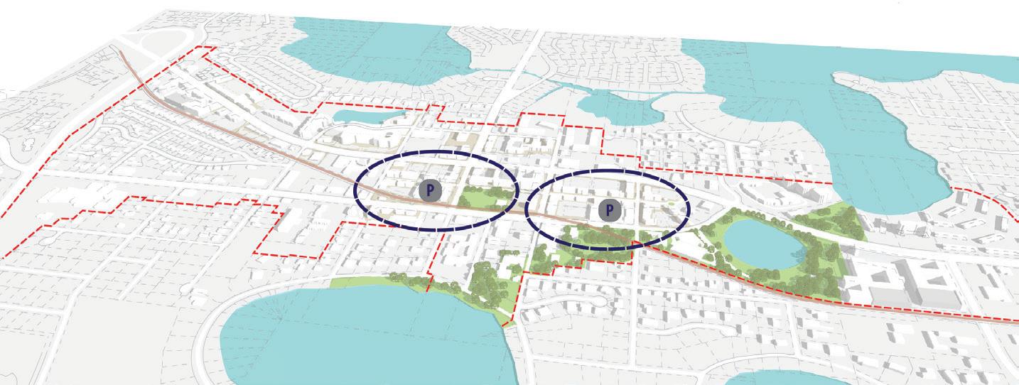
In the Downtown Core, based on a walkshed of about 500’, two public garages should be considered - ideally near Horatio on the north and Ventris on the south. These parking garages could be financed and constructed as a public/private partnership, to meet the needs of both public parking and the parking requirements for mixed-use developments in the core. Garage facades are located on secondary frontages and service drives only. When located on secondary frontages, garages should be articulated like a building.
A shared parking solution may also allow for cultural entities such as the Art & History Museums – Maitland and the Library to use their sites more efficiently, providing a tradeoff in more public open space at each location.


Conceptual vision of Downtown Core redevelopment scenarios showing form and massing of example buildings, Independence Lane extended from George to Lake Lily, and a new City Square.
GREENWOOD GARDENS NEIGHBORHOOD
NORTHERN CORRIDOR - SAWMILL DISTRICT
A Potential Concept of Development
MAITLANDBLVD
MAITLAND AVENUE CORRIDOR DISTRICT
DOWNTOWN CORE DISTRICT
SOUTHERN CORRIDOR - WATERHOUSE DISTRICT

DISTRICTS
THE DEVELOPMENT VISION FOR THE OVERALL DOWNTOWN BREAKS DOWN INTO FIVE SEPARATE DISTRICTS. THE DISTRICTS ARE NOT INTENDED FOR BRANDING, BUT RATHER EACH HAS A DISTINCT REDEVELOPMENT APPROACH. THE OVERALL GOAL IS TO CLARIFY THE DOWNTOWN CORE WHILE STILL ENCOURAGING CORRIDOR REDEVELOPMENT ELSEWHERE.
DOWNTOWN CORE
The Downtown Core is the roughly 1/4-mile radius around City Hall. It is the location of the highest density and intensity of use, for those areas in the DMZD, and is the spot where mixed-use projects are most viable. The core is focused on Independence Lane and its future extension to the north and south, anchored by the park environment of Lake Lily on the south and the new Independence Square on the north.
NORTHERN CORRIDOR - SAWMILL DISTRICT
Development in the Orlando Avenue corridor north of the Downtown Core is focused on the Maitland SunRail station. Development will likely be a commercial and residential, depending on parcel configurations. Mixeduse in this district is encouraged, and will likely take the form of small commercial uses supporting residential infill.
SOUTHERN CORRIDOR - WATERHOUSE DISTRICT
South of the Downtown Core, the Orlando Avenue corridor is envisioned as a multi-use district of commercial, office, workplace, civic, entertainment, and higher density residential uses.
MAITLAND AVENUE
The Maitland Avenue corridor north of the Downtown Core is well established as a medical and professional office district. These uses are envisioned to continue, while retail and restaurant uses may grow as secondary uses in this district.
GREENWOOD GARDENS
Greenwood Gardens is the residential neighborhood between the Maitland Avenue corridor and the rail line. It is envisioned as a stable residential area, maintaining current land use entitlements, sustaining the current pattern of residential development, and benefitting improvements that upgrade the function and aesthetics of the public realm.
A Potential Concept of Development

Downtown Core
The Downtown Core is the area that can become the center of Maitland. It occupies the roughly 1/4-mile radius around City Hall. It is the location of the highest density and intensity of use, for those areas in the DMZD, and is the spot where mixed-use projects are most viable. The Core is focused on Independence Lane and its future extension to the north and south, anchored by the park environment of Lake Lily on the south and a new Independence Square to the north. As the center of culture and leisure in the city, the Downtown Core should stretch east to touch the residential areas along Swoope and Sybelia Parkway, and west to Lake Sybelia and incorporate the Arts & History Museums -
Maitland, the Senior Center, the Library, and the Venue on the Lake. These elements should be connected physically through improved streetscapes and pedestrian connections as well as programmatically through activities that extend these institutions into the community spaces such as Lake Lily and the new Independence Square.
The Downtown Core should feature a wide variety of uses, from restaurants to retail to residential and office. This variety is intended to create a vibrancy of activity throughout the day and to create visitors, shoppers, and parkgoers out of anyone who comes to any one destination in downtown.


Greenwood Gardens
Greenwood Gardens is the residential neighborhood between the Maitland Avenue corridor and the rail line. The neighborhood is the only low density neighborhood within the study area. It is envisioned as a stable residential area, sustaining the current pattern of development and benefitting from improvements that upgrade the function and aesthetics of the public realm. At community meetings, residents expressed their desire to see land uses remain in their current state and for the City to implement the improvements outlined in the Quality Neighborhood Program.
A copy of the Quality Neighborhood Program for Greenwood Gardens is included as an appendix to this report.

400’ 0 North
Selected key improvements contemplated as part of Greenwood Gardens Quality Neighborhood Program (see Appendix for original)
Location of entry roundabout and traffic calming at corner of Robin Hood and Gamewell in Greenwood Gardens.
Bike trail connection in Greenwood Gardens.
Sidewalk and Streetscape Improvements
Rail Corridor Sound Wall
Entry Roundabout and Traffic Calming

Station Corridor
Development in the Orlando Avenue corridor north of the Downtown Core is focused on the Maitland SunRail station. Where parcel depths are shallow, single use commercial or office projects are likely. Where additional depth exists, residential redevelopment is envisioned to occur linked to the transit station. Due to its configuration, access in this district comes solely from Orlando Avenue, putting pressure on this corridor to not only move cars but serve local access and accommodate pedestrians and bikes, as well. Mixed-use in this district is encouraged, but should not be required.
Potential Future Development at Station
Complete Streetscape with Redevelopment
Potential Future Redevelopment

The future development on Maitland Avenue north of the Downtown Core is envisioned to continue to be largely an office location. However, as development in the north portion of the Downtown Core happens, and as Maitland Avenue is made into a strong bike and pedestrian corridor, retail and restaurant uses may grow organically. Comprehensive Plan policies allow these uses within the corridor. Their development should not be at the expense of the Downtown Core, but rather serve as a complementary transition to the neighborhoods outside of Downtown.
Maitland Avenue Corridor
Potential Complete Street Road Diet for Maitland Avenue South of Sandspur
Retail Infill Potential Along Maitland Avenue per Comprehensive Plan Policies
Potential Trail Connection West of I-4
Sidewalk and Streetscape Improvements

Southern Corridor
South of the Downtown Core, the Orlando Avenue corridor is envisioned as a multiuse district of commercial, office, workplace, civic and entertainment, and higher density residential uses. New development in this district should focus on addressing Orlando Avenue and completing the streetscape edge. Where parcel depths allow, access from streets other than Orlando Avenue is encouraged. Circle Drive is identified as an emerging Professional Design District focused around the construction and design industry where smaller scale office uses are encouraged.
Potential Trail Connection to Ravaudage
Streetscape with Redevelopment
Future Redevelopment
ACTIONS: GETTING STARTED
The recommended first steps are timed to coincide with current development activity. Bringing focus to the north end of downtown, with a new Independence Square and extended Independence Lane will generate activity and begin to make downtown look and feel like a special place.
Other projects have a longer lead time and are not as time-sensitive because they are more dependent on private redevelopment. The City can, however, move ahead with remaking Maitland Avenue and studying options for a downtown parking garage to move into property acquisition, if necessary.
Policy Focus
The following policies are key to implementing the Downtown Master Plan:
• Expand Downtown to include Cultural Corridor. Maintain Cultural Corridor zoning for planning purposes.
• Maintain streetscape requirements and provisions requiring buildings built up to road hiding parking.
• Require mid-block alleys to access parking and service areas and allow a maximum of one curb cut per block on Independence Lane.
• Continue to allow retail and office uses where currently permitted along Maitland Avenue.
• Maintain Future Land Use and Zoning of Greenwood Gardens.
Regulations
The following regulatory changes and points of emphasis are key to implementing the Downtown Master Plan:
• Maintain Cultural Corridor regulations.
• Maintain Maitland Avenue Special District Regulations.
• Expand DMZD to include entire east side of Maitland Avenue from Packwood south to Orlando Avenue and include a four-story cap on development on these new DMZD parcels.
• Amend Downtown Maitland Special District to include Architectural Design Standards. In particular, these should address building massing and human scale architecture for the pedestrian realm (below the second floor of buildings.)
Capital Improvements
The implementation of the vision of the Downtown Master Plan will require a number of public, private, and public/private improvements within the public realm.
PROJECT
INDEPENDENCE SQUARE: Develop park adjacent to City Hall as an anchor near the northern end of spine
LIBRARY SPACE AND SITE PLANNING: Conduct a space needs study for Library. If expansion is needed, determine location, potentially with Civic Center expansion.
MAITLAND AVENUE COMPLETE STREET: Initial Road Diet project from 4 travel lanes to 2 travel lanes with center turnlane, on-street parking, and an on-street cycle track from Lake Lily to Sandspur
Reconstruct from Initial to 2 travel lanes with center turn-lane, on-street parking, and multi-use pathway from Lake Lily to Sandspur
INDEPENDENCE LANE DOWNTOWN SPINE SEGMENTS:
PACKWOOD TO HORATIO: Design and reconstruct street and streetscape with parallel parking; shared use with bikes; street trees
HORATIO TO GEORGE: Construct new street and streetscape with parallel parking; shared use with bikes; street trees
PACKWOOD TO VENTRIS: Construct new street and streetscape with parallel parking; shared use with bikes; street trees
VENTRIS TO LAKE LILY: Construct new street and streetscape with parallel parking; shared use with bikes; street trees
GREENWOOD GARDENS: Implement QNP
SANDSPUR ROAD TRAIL: Add 10’ multi-use trail to connect Maitland Avenue to current trail at Lake Sybelia E.S.
In current CIP for design Future year funding need in CIP for construction
Coordinate space needs study
Maitland Avenue Interlocal Agreement with County Future capital funding need in CIP
Future capital funding need in CIP
Funded FY2017
Funded FY2019
Future capital funding need in CIP
Future capital funding need in CIP
Funding in CIP
Funding in CIP
PDE complete; EIS funding in FY2017; CIP funding scheduled for FY2019
$500,000 Design: SHORT Construction: SHORT
$15,000 Create Plan: SHORT Construction: LONG
$2,587,200 Interlocal Agreement: SHORT Design: SHORT Construction: MEDIUM
$4,435,200 Design: LONG Construction: LONG
$1,200,000 Construction: SHORT
$1,200,000 Construction: MEDIUM
$1,300,000
$1,000,000
Design and Construction: Coordinate timing with future redevelopment
Design and Construction: Coordinate timing with future redevelopment
$197,783 Undergrounding; drainage design: SHORT
$270,109 Water line upgrade: MEDIUM
$891,000
Construction: MEDIUM
PROJECT
VENTRIS STREETSCAPE: Streetscape improvements from Maitland Avenue to Orlando Avenue to add parallel on-street parking; improve pedestrian facilities with shade trees; connect sidewalks
PACKWOOD AVENUE STREETSCAPE: Streetscape improvements from Maitland Avenue to Orlando Avenue to add parallel on-street parking; improve pedestrian facilities with shade trees; connect sidewalks
GEORGE STREETSCAPE: Streetscape improvements from Maitland Avenue to Orlando Avenue to add parallel on-street parking; improve pedestrian facilities with shade trees; connect sidewalks
CULTURAL CONNECTOR STREETSCAPE: Improve Packwood Avenue streetscape and intersection with Maitland Avenue to facilitate pedestrian movement between Lake Sybelia and Independence Lane
SYBELIA AVENUE: Widen to 4-lanes between Maitland Ave and U.S. 17/92 to allow more stacking and use of this route (includes rail crossing improvements)
SUNRAIL TRAIL: Create trail from SunRail station to Sybelia Pkwy parallel to, but outside of the FDOT R/W with easements from property owners
Extend current trail from Lake Avenue south to Winter Park (Ravaudage)
HORATIO AVENUE BIKE LANE IMPROVEMENTS: Widen bike lanes and extend bike lanes to U.S. 17/92
HORATIO AVENUE AND SWOOPE INTERSECTION: Signalize intersection to facilitate access to local street network (by allowing left turn from southbound Swoope to eastbound Horatio.)
PUBLIC/PRIVATE PARKING: Develop Cultural Partner sharedparking structure at Packwood Ave and Maitland Ave (with commercial liner space on the first floor facing Maitland Avenue)
PUBLIC/PRIVATE PARKING: Secure two public/private parking locations (one in vicinity of Horatio/Maitland Ave and one in vicinity of Ventris/Maitland Ave)
Future capital funding need. $480,000
Future capital funding need. $120,000
Future capital funding need. $480,000
Future capital funding need.
$1,060,000
Design and Construction: LONG (unless accelerated by future redevelopment)
Design and Construction: LONG (unless accelerated by future redevelopment)
Design and Construction: LONG (unless accelerated by future redevelopment)
Design and Construction: LONG
Future capital funding need. $2,366,900
Work with property owners; future capital funding need.
Work with developers to obtain easements; build trail.
$169,775
$200,181
Design and Construction: LONG
Property owner discussions: SHORT
Design and Construction: LONG (unless accelerated by future redevelopment)
Work with County: Horatio Ave future capital funding need. (include in next capital project) 3R Project: MEDIUM
Work with County and FDOT $280,000 Signal Warrant Study: SHORT
Land acquired Future capital funding need in CIP for parking structures
Future capital funding needs in CIP
$1,800,000
Surface parking: SHORT Structured parking: MEDIUM
$20,000,000 Horatio/Maitland Ave: SHORT
Ventris/Maitland Ave: LONG
REDEVELOPMENT PLAN
Redevelopment of the downtown area requires a comprehensive approach to achieve success. Goals and Objectives can be developed around four primary areas of focus: Economic Development (Business Recruitment and Retention); Design (Physical Environment); Promotion (Image Creation); Organization (Outreach, Bringing all the stakeholders to the table). Annual work plans based around these four points are essential to incremental, measureable results.
Economic Development: The Business Environment
Economic Development in the redevelopment context is building on and strengthening the Downtown’s existing unique assets while recruiting entrepreneurs and growing businesses to reposition the Downtown in the marketplace and move the downtown and the community towards the shared vision.
Business Retention: Develop a strategy to identify and retain those existing business assets that contribute and move the downtown toward the vision. This could include:
• Printed and online restaurant guides and shopping guides,
• Merchant educational seminars,
• Coordinated advertising,
• Retail events, etc.
Business Recruitment: Develop a strategy to identify and target businesses that will contribute and build the downtown toward the vision. This could include:
• Recruitment materials,
• Participation in retail recruiting conferences, and
• Online listings, etc.
Sharing Space: Facilitate discussion between Maitland Public Library and Venue on the Lake on shared space.
Partnering: Build partnerships with The Maitland Downtown Partnership, The Economic Development Council and others to work with the business and non-profit community to strengthen the business climate in Downtown Maitland.
Industry and Organization Outreach: Representation with the International Council of Shopping Centers, Florida Redevelopment Association, Florida Main Street, The National Main Street Center, The International Downtown Association and other similar organizations for networking, best practices and education opportunities in Economic Development.
Design: The Physical Environment
Design is getting the downtown area in top physical condition, addressing transportation and parking needs, providing public space, tracking maintenance, and constructing infrastructure to accommodate the growth envisioned in the Master Plan.
Capital Improvements: Implement capital projects outlined in the Downtown Master Plan:
• Complete design concept and construct Independence Lane from Packwood to Horatio
• Design and construct Independence Square/Park.
• Complete design concept for Independence Lane from Horatio to George.
• Implement Greenwood Gardens Quality Neighborhood Program.
• Design and construct wayfinding system for downtown core.
• Pursue easements for trail route along but outside railroad right-of-way from George Avenue to the SunRail Station.
Land Development Regulations: Modify LDRs to add design guideline elements described in the Master Plan.
Transportation: Identify and incentivize transportation alternatives to connect downtown to the SunRail Station and the Southern Corridor, such as:
• Bike Share
• Tram
• Trolley
• Shuttle
• Uber/Lyft
Beautification: Identify beautification and “décor” projects, to implement directly or through partnerships, such as:
• SunRail Corridor beautification,
• Gateways to Downtown,
• Branding, holiday and special events, banners,
• Holiday street tree lighting, and
• Seasonal flower beds, etc.
Promotion: Image Creation
Marketing is a tool that increases visibility for the City of Maitland and is critical for the vitality of its Downtown District. In order for this to succeed, the community stakeholders, business and property owners, the City of Maitland, and the Maitland Downtown Partnership should connect to implement and foster a unified strategy.
To succeed in building long term economic success for the Downtown, festivals and sustainable events are opportunities that reinforce a district’s positioning and branding. That means they must be targeted at the right audiences and communicated using the right media. One of the greatest promotional tools is that sustainable events further the exposure to the existing businesses in the area by bringing in first-time visitors/users, generating repeat visits and providing for local resident activity and interaction.
Marketing and Branding: Develop ongoing Marketing/Branding activities that promote the downtown, increase awareness by residents of downtown progress and activities, and position the downtown in the marketplace. This can include:
• Brand Extension
• Banners
• Shopping guide
• Dining guide
• Table tents
• Events posters (listing all events for the quarter)
• Special event posters
• Web page
• Social media
Sharing Data: Share Market Research with downtown area partners.
Facilitating Downtown Events: Ensure that festivals and sustainable events occur in the downtown area through facilitation, sponsorship, participation, partnering, coordination and/or producing events. These can include:
Weekly events such as:
• Maitland Farmer’s Market
Monthly events such as:
• Thursday night Happy Hour Event, i.e.“Thirsty Thursday”
• Friday night Street Party Music event, i.e. “Getdown Downtown”
• Downtown Movie Night in Independence Square/Park
• Exotic Car Show
Annual events such as:
• Howloween Pet Costume Contest
• Rotary Art Festival
• Season of Light
• Pookie’s Pet Rescuefest
• Florida Film Festival
• 5K events
Retail Events such as:
• Wine Tasting/Stroll
• Everything Chocolate
• Taste Maitland
Organization: Outreach
Bringing all the stakeholders to the table and getting everyone working towards the same goal by building consensus and partnerships.
Engaging Downtown Stakeholders: Engage Downtown area stakeholders through participation with the Maitland Downtown Partnership and the Maitland Area Chamber of Commerce.
• Participate in monthly meetings of the downtown area partners/stakeholders to facilitate communication, coordination and cooperation.
• Work with MDP to create MDP Work Plan
• Create contact list of area HOA’s, schools and recreation contacts
• Downtown Area Partners/Stakeholders include:
• Art & History Museums – Maitland
• Asbury United Methodist Church
• Audubon Birds of Prey Center
• Church of the Good Shepherd
• Enzian Theater
• Holocaust Memorial Resource and Education Center of Florida
• Jewish Academy of Orlando
• Jewish Federation of Greater Orlando
• Maitland Area Chamber of Commerce
• Maitland Men’s Club
• Maitland Montessori School
• Maitland Presbyterian Church
• Maitland Public Library
• Maitland Women’s Club
• Park Maitland School
• Performing Arts of Maitland
• Rotary Club of Maitland
• Roth Family Jewish Community Center
• Venue on the Lake
• Engage the Community through Volunteer Opportunities with the City and partner organizations. These could include:
• Beautification work days
• Special events
• Project committees