


In 1969, the late Bruce McCarty, FAIA, then-President of the local AIA, alongside several local architects, returned from a trip to the Community Design Center in Philadelphia and gathered roughly forty local professionals to discuss the need for such a center in this region. On April 15th, 1970, the East Tennessee Community Design Center (ETCDC) was founded.
The objective of ETCDC has been to make East Tennessee a better place by bringing professional design and planning assistance to communities and organizations lacking resources to acquire those services. Our mission is to Envision, Inspire, and Improve East Tennessee communities through design, collaboration, and leadership. The ETCDC also serves as a catalyst to initiate projects within our service area and serves as an advocate for quality design in the public realm. The ETCDC offers these services through the pro-bono contributions of area architects, landscape architects, planners, engineers, and other professionals.
Since its founding, the ETCDC has completed over 1,200 projects in the 16 county region it serves! This is due to the local professional community providing over 100,000 hours of volunteer time.
The Community Collaborative is a focused effort between multiple organizations on the challenges facing our communities. The goal of the Collaborative is to highlight an area’s history, bring awareness to its future potential, and then promote sustainable growth. Each year a focus area or issue is established, community input is gathered, and multiple studies and efforts are performed. The Collaborative concludes each year in a publication that summarizes the research, designs, concepts, and efforts performed that year, and some years a public event celebrates this effort. This discourse in turn begins to shape public policy and private development strategies. The Collaborative is the vehicle for our community to envision the possibilities of our region and shape our collective aspirations for the future.
In 2022, the focus of The Collaborative was Martin Luther King, Jr. Avenue, a key street in East Knoxville. The following pages include the efforts of the ETCDC based upon local input, as well as the work of Knoxville-area architecture firms to envision the potential future of one parcel along the corridor.
Note: These are the usual organizations and entities involved in The Collaborative, but they may change in any given year, such as in 2022, dependent on multiple factors, including the availability of representatives from the organizations.

The originial catalyst for the 2022 Community Collaborative site occuring along Martin Luther King, Jr. Avenue was our work with the nonprofit Alliance House Community Coalition. It was their desire to see imporvements along the corridor which led us to create a survey for local residents in East Knoxville to respond to. Due to the ongoing concerns with the pandemic, our survey was crafted to be taken online and the link was sent to AHCC staff for distribution within the community. After gathering basic information on the survey, we asked a series of questions to gauge the types of improvements along the Avenue that participants would like to see. These questions ranged from asking participants what specific types of businesses they would or would not like to see nearby, the types of physical improvements they prefer (this included categories such as bus stations, public art, bike lanes, street lighting, and more). The survey even included a question asking about their preference of ‘street section’ - how a street is built - for a specific portion of the road. The survey ran over the duration of a few months in the Summer of 2021 and these results were compiled that November. The designs - which can be seen in the section titled ‘The Vision’ - came about after the results were compiled and were directly influenced by them.

The first series of questions in the survey sought to discover the demographics of those answering the questions.
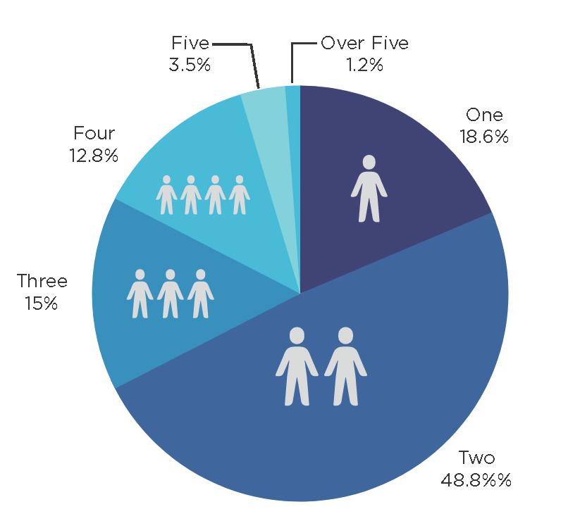


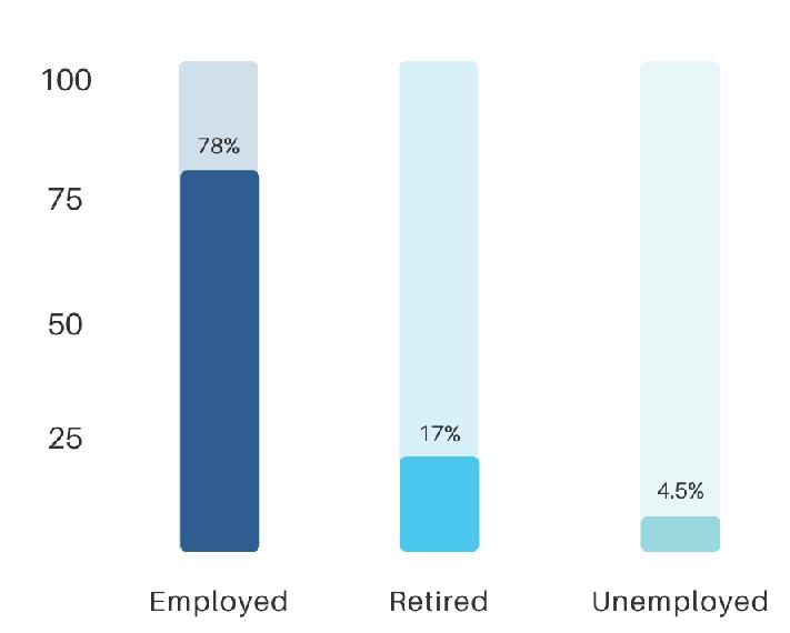
Question 1, seen to the right, asked where respondants lived, so that we could know how close to MLK, Jr. Ave. they were. Questions 2 through 4, seen below in order from left to right, asked the questions:
‘What is your age group/generation?’
‘What is your household/family size?’
‘What is your employment situation?’
These questions were in collaboration with our project client, the Alliance House Community Coalition.
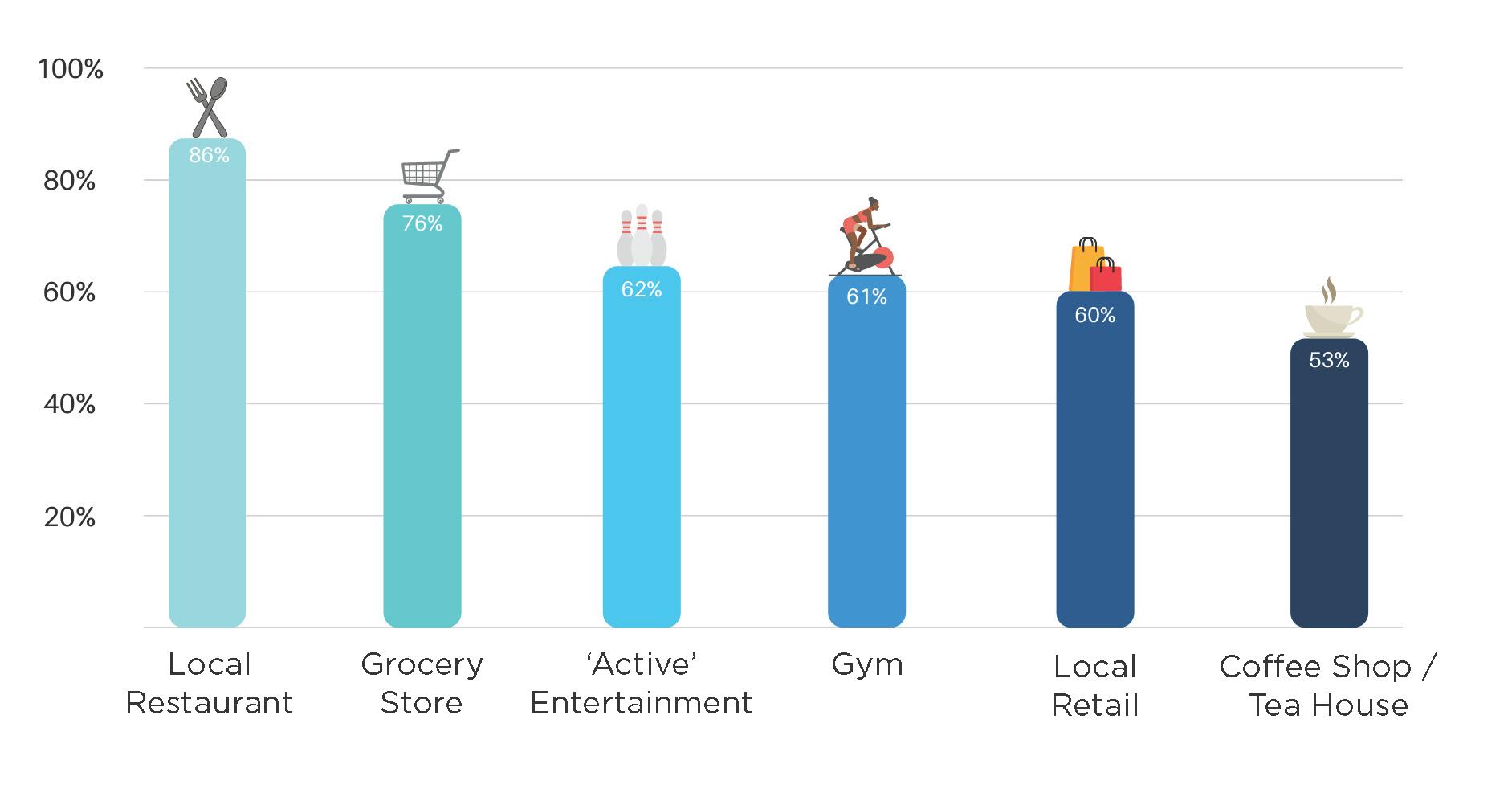
Questions 5 and 6 dealt with specific business types along the corridor. Question 5, seen at the top, asked which businesses people would like to see in the area that either currently didn’t exist or were few in number.
Question 6, shown at the bottom, asked the opposite of question 5; which business types residents did not wish to see along the corridor.
While our designs do not take into account specific business types, this information is valuable to have going forward so that public and private investment is aimed in a direction that we know the community will support from the beginning.


historic located centrally proximity diverse access homes
close diversity community
The thing people said they liked the most about living near MLK Jr. Avenue was the location in relation to downtown. Other key things included historic homes and the diversity of the area, as well as the sense of community.
police sidewalks safety less guns entertainment
grocery lights
nice facades local business
The things people cited most as being able to improve their quality of life along MLK Jr. Avenue included more greenways, parks, and police presence. Other mentions were: more sidewalks, street lights, businesses (like a grocery store), and improvements to existings facades and buildings.
Note: These answers are shown in what is called a ‘word cloud’ where the more often a word or phrase is given as a response, the larger the word appears. The colors in the word cloud are illustrative only (they do not mean anything).


Note 1: Details on what a traffic calming study would include were not given, though most studies are inherently similar in their measurements (amount of vehicles per hour, vehicle speed, etc.).

Note 2: Stoplights would be at the intersection of the two mentioned streets and MLK Jr. Avenue only.
Note 3: A raised intersection is an intersection in which the road rises to meet the height of the sidewalk, thus forcing vehicles to slow down (the intersection acts as a speed-hump) and creating a safer crossing for pedestrians.
For this question in the survey, we asked respondants to consider the street ‘profile’, or how the street is physically built from one side to the other. This includes the widths of elements like sidewalks or bus stations, whether or not there are bike lanes or on-street parking, if there is a median, and other infrastructure.


Participants ranked four optionsincluding the existing profile of the street, seen on the right - from 1 to 4, with their answers being weighted. This means that a top choice (ranked as a 1) would recieve more points than a last choice (ranked as a 4). An option finished based upon the total number of points it recieved, not just the total number of first place votes it had.
This question only applied to the portion of the corridor from Olive Street to Cherry Street, which is highlighted in the top right.

1st Place: Raised (level with the sidewalk) bike lanes on both sides of the street, seperated from road by concrete curbs and planting strips; one side of the street has a double-width sidewalk to allow for outdoor dining Score: 3.2/4

2nd Place: Score: 2.9/4
Raised (level with the sidewalk), bike lanes on both sides of the street, seperated from road by planter strips; one side of the street has space for street parking
These results show us that not only do respondants want protected bike lanes and more sidewalk area, but they value them above street parking.

The last section of input was the visual preference survey (VPS) which asked respondants to choose their top two of four options in various categories of infrastructure and design, such as housing types, greenway locations, street light styles, and types of public art.

Shown on the adjacent page, the top choices of each category are given alongside the percentage of votes that choice recieved as well as a representative photo of that choice. Respondants knew that the photos they were voting on were representative only and that they were selecting, for example, singlefamily homes as a type and not a specific style of home, or that they were choosing public art on walls as opposed to streets, and not a specific mural or even style of art.


Some of the top responses, such as the ‘Street Trees’ category, are overwhelming at 70% of all votes. Others, like ‘Bike Lanes’, are at 38% because second place may have gotten 35% and the third place 30%. In the complete results packet we note this, but for the purposes of this book we are choosing to show just the top choice.


Above: examples of the categories and options to choose from in the community survey Opposite: the selections from every category in the VPS that came in first place


Following the completion of the community input survey in the Summer of 2021, the results were considered alongside other previous area studies from 2006 and 2009. Taking into account best practices for urban planning and design, a vision plan for the corridor was created.
Per the vision of our client, The Alliance House, the corrdior was subdivided into three segments. From west to east those segments are:
1. ‘Downtown East’ - spanning from North Olive to North Cherry Streetswhere the bulk of commercial spaces would be located
2. A central segment - spanning from North Cherry Street to South Hembree Street - which was found to be best suited for park and outdoor space acting as a hub for greenway connections
3. A final section spanning from South Hembree to Castle Streets which centered on Austin East High School and ways to improve the student experience of that area.
Over the following pages you will see the designs and many of the things which the community noted in the survey that they would like to see. These include wide sidwalks, curb-protected bike lanes, parking loaded onto alleys or otherwise hidden, strong street edges, better transit stops, and more green spaces and trees. Generally, all of the things that make for a charming, denser, walkable main street.


In the plan, we attempted to keep existing buildings as they were, though exceptions were made for the overall design of the street to be cohesive. This plan should be understood as simply one vision for what the corridor could be, based on community input and best practices of people-friendly city design. It doesn’t commit to any building actually be demolished any more than, when a new building is proposed, it doesn’t dictate the specific footprint, building type, or size. The sizes, shapes, and locations of new structures are merely illustrative of what infill housing and commercial structures could do to help shape the corridor into a more walkable area.

The same should be said of other elements, such as parks, parking lots, plazas, or specialty street pavements (such as those illustrated on the righthand page in the maroon). This plan is meant to inspire the community and give them a way to look at what is currently there and imagine what instead could be. The location of park spaces, parking lots, or speciality paving, while suggested here in locations believed to be beneficial, are not in any way a final design; they are based upon the dozens of responses from the neighbors in our community input survey.


Change along the corridor will require the efforts of private developors, City leaders, and neighborhood residents. The role of the ETCDC in the creation of the Vision Plan is to serve as a catalyst to help those groups come together over a general, longterm dream and spur creativity to envision a Martin Luther King, Jr. Avenue made better for all.
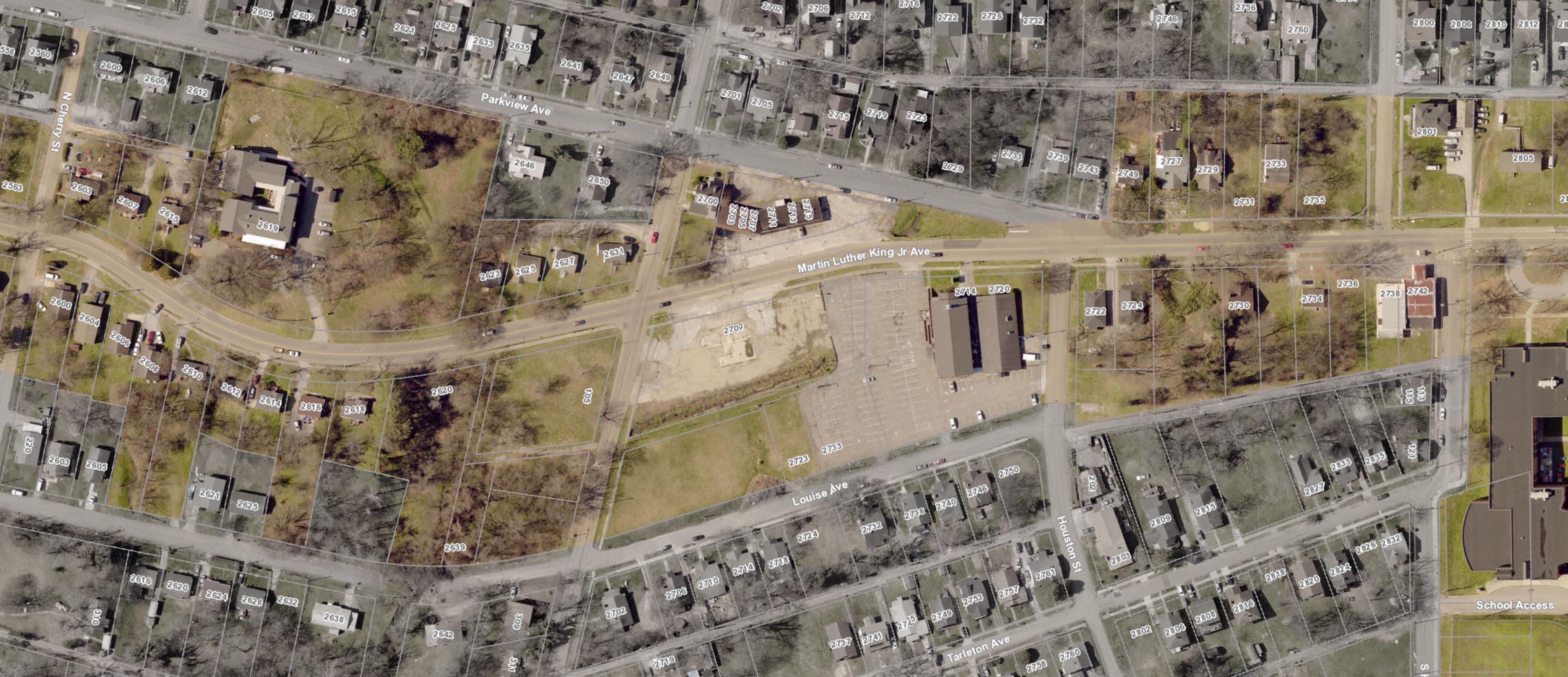


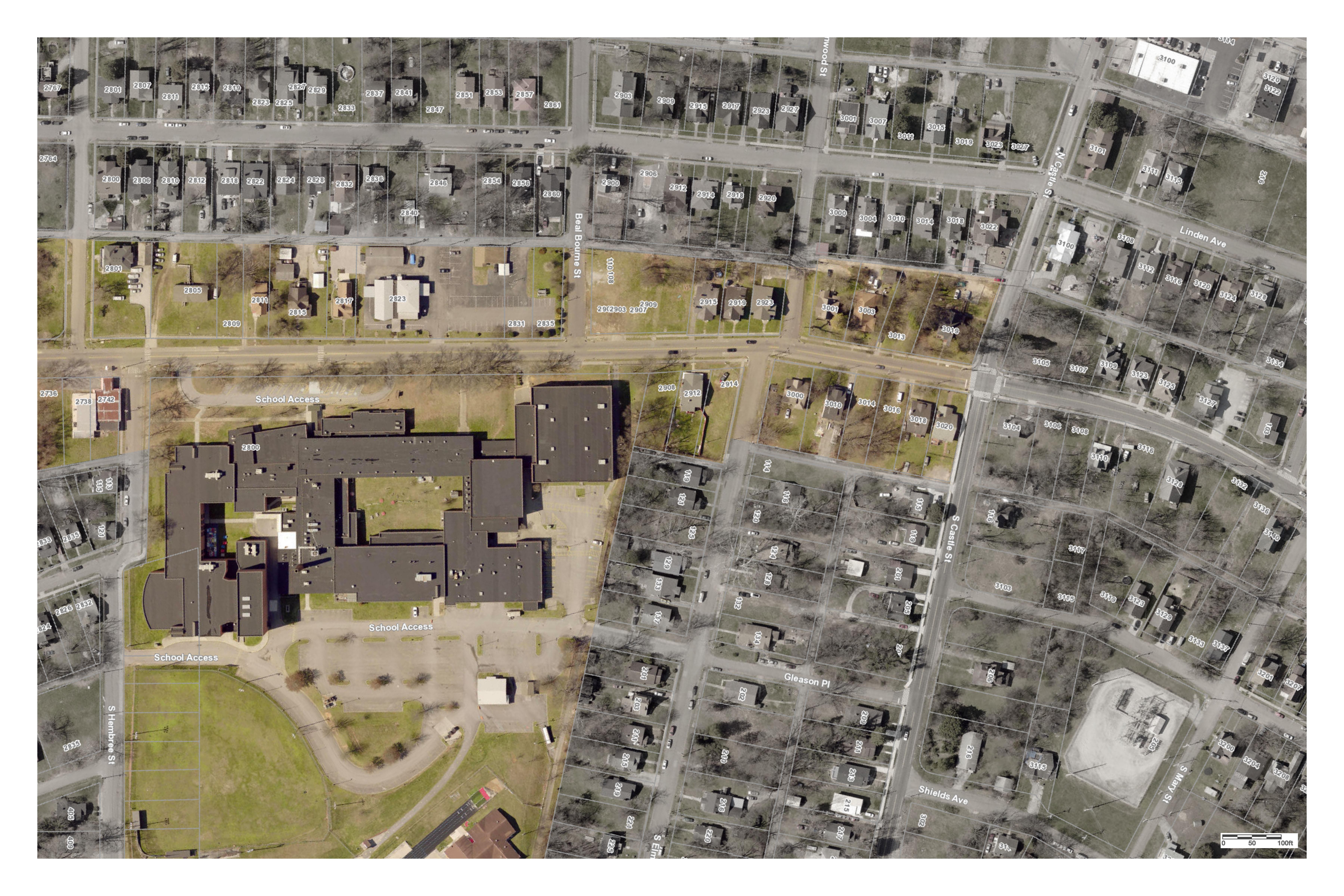


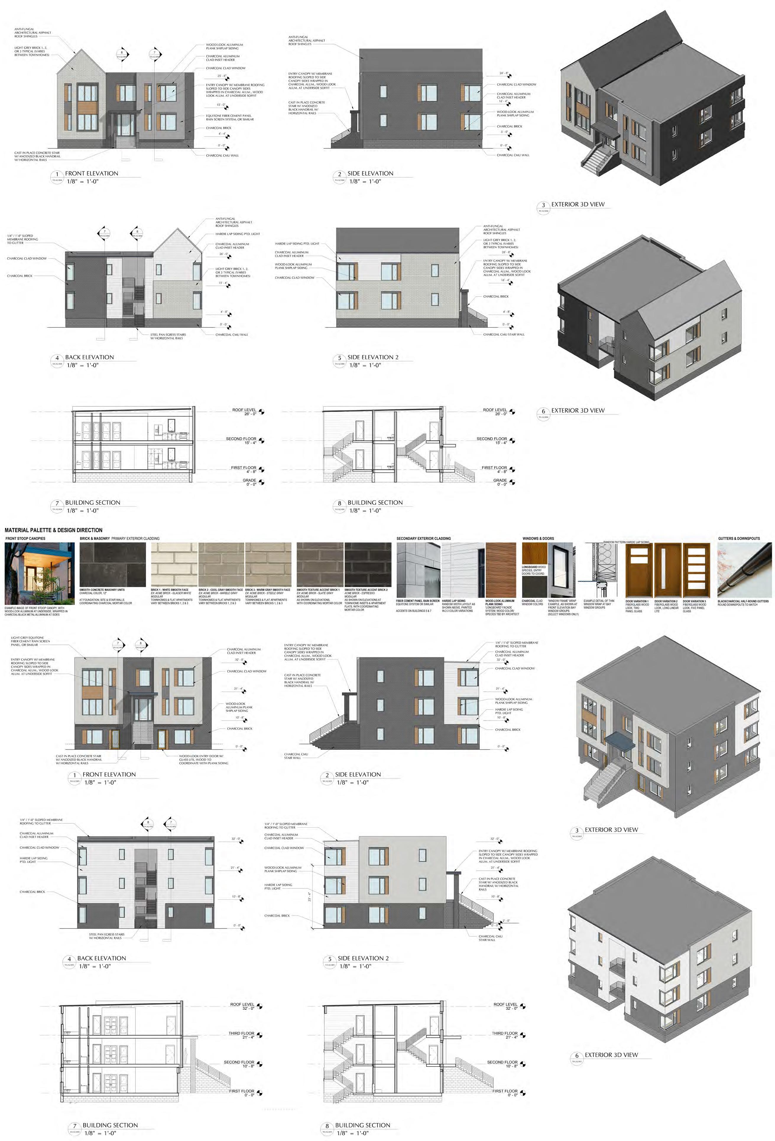
Part of the annual Community Collaborative is the Design Charrette, a multiweek event in which we ask local architecture and design professionals (along with any other interested people) to form teams and work on a schematic design for a site we have chosen in the Collaborative area. As with our Vision Plan, these designs are purely imaginative and, while we ask teams to take codes and zoning into account, they are meant only to inspire the neighborhood as to what could be.
For the Martin Luther King, Jr. Avenue Charette, we chose a city-owned parcel, along with two optional city-owned parcels adjcanet to the main spot, in the most western section of the corridor, in the Five Points neighborhood. The main parcel was redeveloped years ago by the city into a suburban-style shopping center that currently houses a radio station and a few local retail spaces, but it largely underutilized as a piece of urban land. It is bound on the north by MLK Jr. Avenue, on the west by Ben Hur Avenue, the south by Louise Avenue, and the east by Parham Street. You can see the parcels highlighted on the right-hand page.
The teams were given the results of the community input survey so they could base their designs on community desires. They were asked to include mixed-use developments and to take walkability and bikability into account.
We thank all of the teams for their thought-provoking and exciting designs and all the participants’ willingness to volunteer countless hours for the betterment of the community. We hope the designs inspire many discussions going forward.


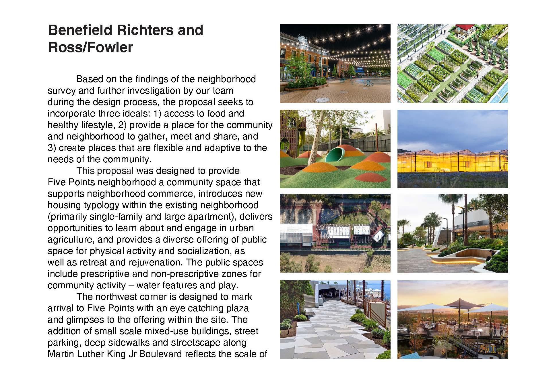
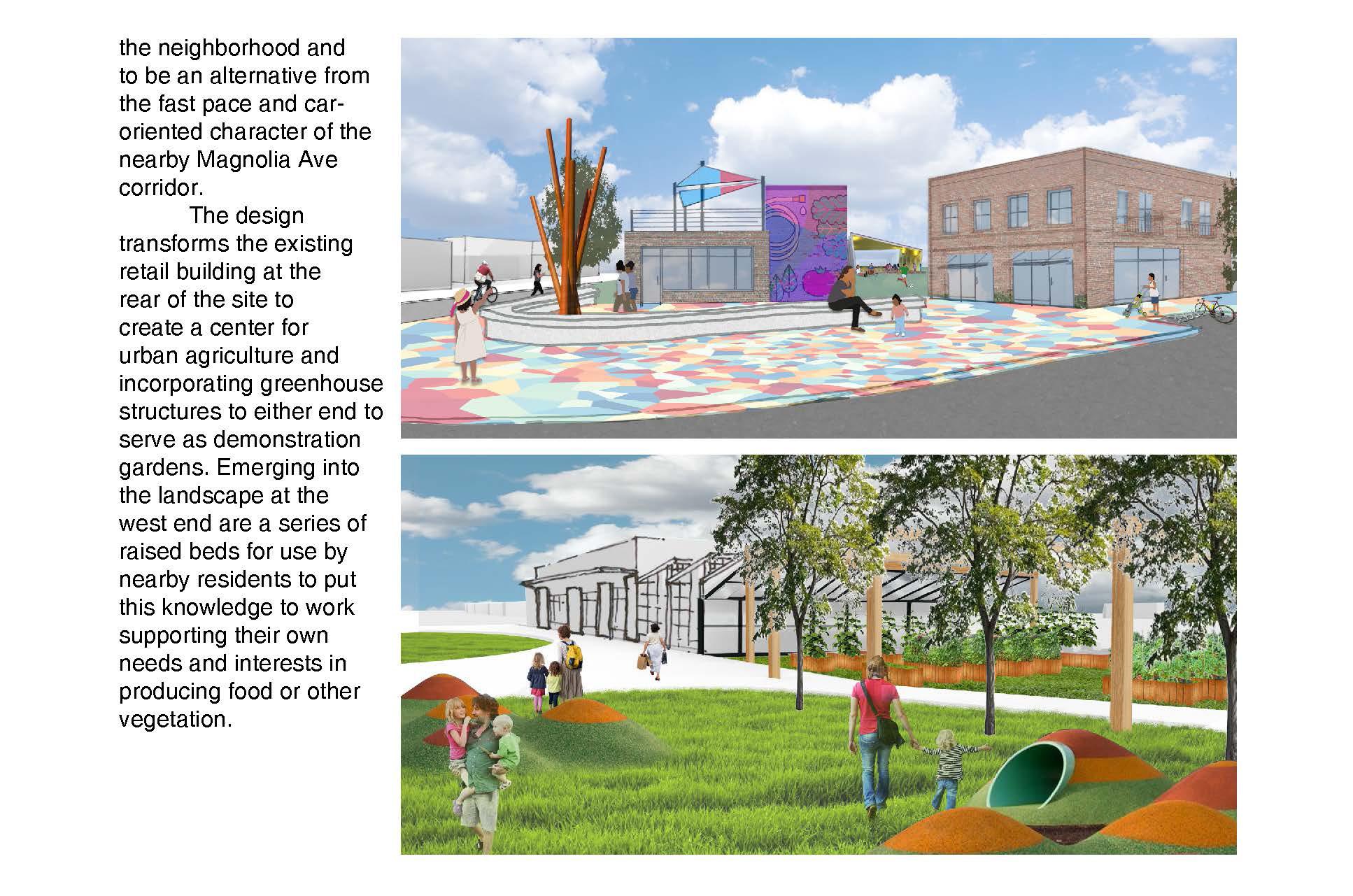


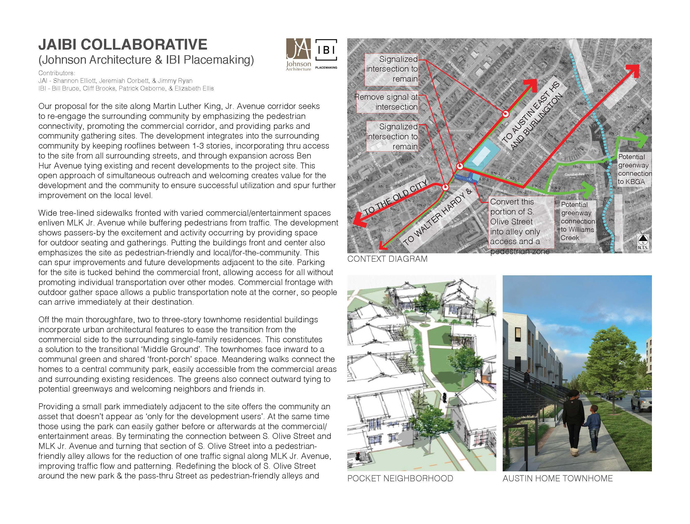




Every October as part of the American Institute of Architect’s (AIA’s) celebrations of Architecture Month in Tennessee, the East Tennessee Chapter hosts what it known as Design Slam. The Slam is similar to our Design Charrette in that there are several teams of designers crafting a schematic, vision-level design for a pre-chosen site. It differs in that the teams do all of their designs in one evening, over the course of just ninety minutes, and the event is held at a local bar and has public presentations and an award ceremony at the end.
In 2021, The Slam was held at Hi-Wire Brewing on Sevier Avenue in South Knoxville. A portion of the same site that would be used for the Design Charrette - a corner of the plot at the intersection of MLK Jr. Avenue and Ben Hur Avenue - was used for this event, and the teams responsed with ingenious and beautiful designs considering their time constraints.
Three teams with a total of sixteen designers participated and the designs were judged by a panel of three, including our own Executive Director Duane Grieve, FAIA. Thank you to all the teams and the designers for joining us for some beers and a fun evening of envisioning a small but important corner of Martin Luther King, Jr. Avenue.


The primary objective and hope of The Community Collaborative is that our multi-organizational efforts in any of our chosen locations will foster thoughtful designs and discussions. There is also the hope that those designs and discussions will serve as the catalyst for future developments in those places. To highlight that, updates to our previous two Collaborative locations, the Burlington Neighborhood and Sutherland Avenue, are below. These updates are current as of the publication of this book in the November 2022.
Our first Collaborative was in 2019 in the east Knoxville neighborhood of Burlington. The Vision Plan created for their historic main street, based on community input, included physical improvements such as lighting, sidewalks, and intersections to improve pedestrian safety. Prof. Marleen Davis’s 3rd year Studio at UT’s College of Architecture also spent a semester envisioning the future of the neighborhood, and later presented their designs to City officials and others. Since then, the City of Knoxville and State of Tennessee have come to recognize the value of this part of town. The City has committed a minimum of $2,000,000 to start improvements, and the State helped to fund several newly stamped crosswalks. The crosswalks are in a burgundy-colored asphalt in order to draw better attention and improve the safety of those using them. As well, a facade on a key intersection has since been refurbished, and local improvements continue to occur. Momentum in the area is gaining speed and the future looks bright.
Our second Collaborative effort was along the Knoxville corridor of Sutherland Avenue in 2020 and brought plenty of challenges. A public input session at the Armory building near West High School in February brought nearly 100 residents to participate and tell us what they wished to see along the corridor. Within a matter of weeks the pandemic began and it changed all further outreach for the year to a virtual format. While a Vision Plan like the one in Burlington was not created, our partnership with Prof. Marleen Davis’s 3rd year Studio at the College of Architecture continued. They took the community input and used it to envision the street in the year 2050. One of our other partnerships, with Keep Knoxville Beautiful, helped to transform a long, blank wall along S. Concord Street in to a beautiful mural, acting as a gateway to this eclectic street.


for the grant which made the publication of this book possible.

