From sunshine to snowstorms, a look at the ever-changing weather of our region
DNT EXTRA | October 2017
Northland Weather


ppaFamilyFoundation Clean Energy nc. Investor s Properties • CenturyLink • Cirru • Como Oil &Propane • Consolidated Communications • CW Technology • Duluth News Tribune • Enbridge (US) Inc. • LHB • maurices • PhysioCon ol Data • Stewar tTaylor Printing • Superior Water, Light, • Zeigeist Ar ts Employees of the following companiescan join MPECU: www.mpecu.com Equal Housing Lender | Member ship Eligibility Required | Federally Insured By NCU p e Co i hys o-Control CUMPE ices in LHB mau n jo ca nie mp i k us tu l C C C on f t nd s g y F ye or r ti am p ro nc p E SAVE OVER $785 AYEAR Bank with MPECU! • A.H. ZeppaFamilyFoundation • ALLETE Clean Energy • ALLETEInc • ALLETE Investors • ALLETE Properties • AT&T • BNI Coal • CenturyLink • Cirru • Como Oil &Propane • Consolidated Communications • CW Technology • Duluth News Tribune • Enbridge (US) Inc. • LHB • maurices • PhysioCon ol Data Solutions • Stewar tTaylor Printing Co. • Superior Water, Light, &Power • Zeigeist Ar ts Employees of the following companiescan join MPECU: www.mpecu.com Equal Housing Lender | Membership Eligibility Required | Federally Insured By NCUA p e Co i hys o-Control :CUMPE ices in LHB mau n jo ca nie mp i k us tu l C C C on f t nd s g y F ye or r ti am p Pro nc pp E ETE ET Z A A A SAVE OVER $785 AYEAR Bank with MPECU! ppaFamilyFoundation Clean Energy nc. Investor s Properties • CenturyLink • Cirru • Como Oil &Propane • Consolidated Communications • CW Technology • Duluth News Tribune • Enbridge (US) Inc. • LHB • maurices • PhysioCon ol Data • Stewar tTaylor Printing • Superior Water, Light, • Zeigeist Ar ts Employees of the following companiescan join MPECU: www.mpecu.com Equal Housing Lender | Member ship Eligibility Required | Federally Insured By NCU p e Co i hys o-Control CUMPE ices in LHB mau n jo ca nie mp i k us tu l C C C on f t nd s g y F ye or r ti am p ro nc p E SAVE OVER $785 AYEAR Bank with MPECU! .H. ZeppaFamilyFoundation ALLETE Clean Energy LLETEInc ALLETE Investors LLETE Properties AT&T BNI Coal • CenturyLink • Cirru • Como Oil &Propane • Consolidated Communications • CW Technology • Duluth News Tribune • Enbridge (US) Inc. • LHB • maurices • PhysioCon ol Data Solutions • Stewar tTaylor Printing Co. • Superior Water, Light, &Power • Zeigeist Ar ts Employees of the following companiescan join MPECU: www.mpecu.com Equal Housing Lender | Membership Eligibility Required | Federally Insured By NCUA p e Co i hys o-Control Solutio :CUMPE ices in mau n jo ca nie mp i k us tu l C C C on f t nd s g y F ye or r ti am p Pro nc pp E ETE ET Z SAVE OVER $785 AYEAR Bank with MPECU! eppaFamilyFoundation ALLETE Clean Energy EInc. ALLETE Investors ETE Properties Coal • CenturyLink • Cirru • Como Oil &Propane • Consolidated Communications • CW Technology • Duluth News Tribune • Enbridge (US) Inc. • LHB • maurices • PhysioCon ol Data Solutions • Stewar tTaylor Printing • Superior Water, Light, &P • Zeigeist Ar ts Employees of the following companiescan join MPECU: www.mpecu.com Equal Housing Lender | Member ship Eligibility Required | Federally Insured By NCUA p e Co i hys o-Control :CUMPE ices in mau n jo ca nie mp i k us tu l C C C on f t nd s g y F ye or r ti am p Pro nc pp E SAVE OVER $785 AYEAR Bank with MPECU!
Happy anniversary, DNT Extra. It’s hard to believe that it’s been a year already since our inaugural DNT Extra was published in October 2016 — “Twin Ports: Maritime heritage of Duluth and Superior.”
Our second edition
hit your doorsteps in April — “Beer Boom: The growth of craft brewing and distilling in the Northland.”
This fall, we decided to tackle a topic that affects us all every day, and that some of us are more than a little obsessed with: the weather.
When asked, everyone seems to have a favorite season, but each of the Northland’s seasons has distinctive weather charms: soft winter snowfalls with big flakes; spring rain falling on rapidly-growing green grass and leaves; the distant rumble of an approaching summer thundershower; colorful leaves falling through crisp autumn air.
But, as we all know well, those seasons also each have extreme weather events: winter blizzards that pile up several inches of snow and close schools and businesses; heavy, pounding spring rains that cause flooding; summer thunderstorms that bring heavy wind, rain and hail, knocking down trees and knocking out power; late autumn gales that wreak havoc on Lake Superior and the surrounding region.
So, as autumn begins to give way to winter, we invite you to explore Northland weather with us on the pages of this edition of DNT Extra.
We already are looking ahead to the topics we’ll explore in future editions. So, if you have any ideas, please let us know. Who knows? Your DNT Extra idea could be delivered to your home or business in a few months.
Thanks again for reading the Duluth News Tribune and DNT Extra.
Rick Lubbers is the editor of the Duluth News Tribune. Contact him at (218) 723-5301 or rlubbers@duluthnews.com.

4
Lake effect
A look at how Lake Superior influences our weather all year long
14
Warmer world
Northland piles up examples, impacts of changing climate and warmer weather
22
Weather glossary
Definitions and explanations for some Northland weather terms
10 Safe harbor
Commercial sailors’ attitudes about weather changed with sinking of Edmund Fitzgerald
20
Northland forecasting
Predicting the weather in the Northland is a delicate balance of technology, geography
26 Halloween snowstorm
A look back at the 1991 storm that brought the region to a standstill
30 Outdoors weather
Hunters and anglers read the weather carefully — and go out anyway
36
Northland almanac
Weather records and statistics, and a listing of memorable Northland storms
October 2017 • DNT Extra 3
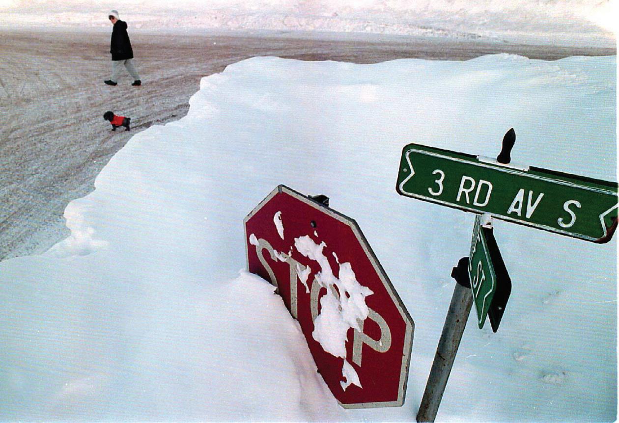
Cover photo: Joel Krochalk is surrounded by snowdrifts as he clears his driveway in Duluth in April 2013, the snowiest month on record in Duluth. (Bob King / rking@duluthnews.com)
Rick Lubbers
Page design for this section by Renae Ronquist. Editing by Andrew Krueger, Rick Lubbers and Beverly Godfrey. Assistance with graphics from Gary Meader.
Tornadoes rare but still possible on Superior’s shores
By Peter Passi ppassi@duluthnews.com

Lake Superior can be both blamed and blessed for the influence it has on weather here in the Northland.
It plays a well-known role in producing dense fog and copious quantities of snow, but the same body of water also has a calming effect on other types of weather systems.
For instance, tornadic activity is a rarity in close proximity to the big lake, and its typically frigid water is the reason why, said Dan Miller, a meteorologist for the National Weather Service office in Duluth.
4
Extra • October 2017
DNT
“One of the ingredients that is necessary (for a tornado) almost all the time is a source of really warm, moist, unstable air right at the surface. So, in terms of temperature and dew point, we’re talking about air masses that have temperatures maybe in the 70s to lower 80s, with dew points in the mid60s to lower 70s — not really oppressively hot and humid but a warm, sultry kind of thing. Obviously, if the Lake Superior marine layer and lake breeze surges inland, you simply don’t have that. You can still get thunderstorms, but they might be rooted in
Continued on page 6

October 2017 • DNT Extra 5
A quartet of kayakers and stand-up paddleboarders cross the glassy, ice-dappled waters of Lake Superior to the shore in Canal Park in May 2014. They were promoting the “Vote Duluth” effort to win Outside magazine’s “Best Towns” contest. (Andrew Krueger / akrueger@duluthnews.com)
an air mass a couple thousand feet above the surface, above that cold, dense marine layer that surges inland during the afternoon and evening hours,” he said.
“So when we do get thunderstorms on those days, in meteorological terms, we say they become elevated. In other words, the parcels of air that are actually driving the thunderstorm and ascending into the

updraft of that storm are not originating from right near the ground. They’re originating from 1,000 or 2,000 feet above the surface, and it’s very difficult, if not even impossible, to get tornadoes to form when you have that shallow layer of cool and stable air right near the surface, because that’s what the lake generates,” Miller explained.

6 DNT Extra • October 2017
About three-dozen young men from Two Harbors were hired as extra employees to clean up lumber tossed about by a tornado at the J.C. Campbell Lumber Co. yards on Aug. 6, 1969.
(News Tribune file photo)
St. Louis County sheriff’s deputy Robert Ojard surveys debris of a Boulder Lake cabin demolished by a tornado in August 1969.
(News Tribune file photo)
Geoff Coulson, a meteorologist for Environment Canada in Thunder Bay, Ontario, concurred.


“When we talk about low-level storms — thunderstorms that have developed from surfacebased instability — when those storms move across the much cooler waters of Superior it’s a brake on that activity,” he said.


“The thunderstorms themselves need that warm, moist air in the lower levels of the atmosphere to feed them. They’re the fuel that they need to continue to form and to grow. But when they encounter the much cooler waters of Lake Superior, that’s like literally dousing them with cold water. They lose a lot of the energy and warmth and moisture that they need from the lower level as they go across the cooler water of the lake,” Coulson said.
While uncommon, tornado-producing systems still can and do form in the Twin Ports, however.
On Aug. 9, 2012, a waterspout was sighted a couple miles offshore from Duluth’s Sky Harbor Airport. The relatively weak F-0 twister crossed Minnesota Point, the harbor and then dissipated at Barker’s Island in Superior.
Also, on May 26, 1958, a tornado touched down in Duluth Heights, tracking nearly seven miles to the northeast before lifting back into the sky just south of Arnold Road.
But Miller points to the Aug. 6, 1969 tornado outbreak as the best evidence that a severe tornado could bear down on the Twin Ports some day. That powerful system produced 13 tornadoes in
Continued on page 8


Today

October 2017 • DNT Extra 7
Nummi Jewelers has weathered many a storm during its 66 years as a family-owned business. One that stands out in the mind of owner Dale Nummi is the Halloween storm of 1991 that dumped more than three feet of snow on the Northland. Like that one-of-a-kind storm you can find one-of-a-kind jewelry at Nummi jewelers, your family-owned store since 1951. Today Nummi Jewelers is the jewel it has always been – family-owned, providing friendly service and attention to detail, in any weather.
www.nummijewelers.com 1120 Belknap St., Superior, WI 715-392-3470 Your HOMETOWN
as always, we weathered the storm.” Monday-Friday 9 am-5:30 pm • Thursday 9 am-8 pm • Saturday 9 am-3 pm
Nummi Jewelers is the jewel it has always been — family-owned, providing friendly service and attention to detail, in any weather.
“Just
Bill Shipley carefully makes his way toward his Park Point home after making a trip to a nearby store in December 2007, amid strong winds off Lake Superior. “Isn’t this something,” said Shipley, who was surprised by the intensity of the wind. (News Tribune file photo)
Minnesota, including an F-3 twister which touched down near Boulder Lake, north of Duluth, and traveled more than 17 miles to Two Harbors, claiming the lives of two people and decimating a lumber mill.
“I always go back to that event in terms of public education and safety preparedness,” Miller said.
“To me, the lesson from that Aug. 6, 1969 event is that yes, even though Lake Superior and the generally cool, stable marine layer does have a tendency to prevent significant tornadic storms from affecting the Twin Ports, if it can happen in Two Harbors, at some point there probably will come a day — that could be next summer or 200 years from now — when something similar to that could happen in Duluth or Superior, despite their close proximity to the lake.
Coulson said the large lake exerts a year-round influence on the weather of the Great Lakes region.
“Due its size and depth, Lake Superior is more like an inland sea than a lake,” he said.

While the marine influence of Lake Superior can suppress some kinds of weather, Coulson said it also can have just the opposite impact. In places inland from the lake, Coulson said the lake breeze can spawn turbulent weather.
“On summer afternoons, we’ve got the land warming up fairly substantially. That air is rising over the land, and it’s replaced by cooler air coming in from the lake itself. And where what we call these lake breeze fronts form — that’s where the lake breeze penetrates inland to a certain distance and then meets another flow of air. Where they
meet, we can get lifting occurring. So these lake breeze fronts, as we refer to them, can be areas where thunderstorms will fire up — not right near the lake itself but some distance inland. Maybe 5, 10 or 15 miles from the shore, we can see these lines of storms forming,” Coulson explained.
And while lake-effect and lake-enhanced snow can occur just about anywhere around the lake, certain places see a lot more
of it than others. Among those locales are Gile and Hurley in Iron County, Wis., where cold northwest winds moving across the relatively warm waters of Lake Superior meet land — and drop a lot of snow.
Gile saw more than 50 inches of lake-effect snow in less than four days in November 2014.
Duluth may not see as much lake-effect snow — but it can happen, sometimes in unusual
8 DNT Extra • October 2017
The saltie Isa is reflected in calm waters on Lake Superior in June 2013. (Bob King / rking@duluthnews.com)
ways.

A narrow band of lake-effect snow dropped 13 inches of snow on the Morgan Park neighborhood in March 2017. And in December 2007, another narrow band of intense lake-effect snow dropped up to 17 inches of snow from downtown to West Duluth in about six hours, while other parts of the city saw minimal snowfall. u


October 2017 • DNT Extra 9 Come Try on New Styles! Duluth Grand Rapids Hibbing Maple Grove Road, Duluth (across from Target) | BendersShoes.com Mon. - Fri. 9am -7pm, Sat. 9am - 6pm, Sun. 11am - 5pm | (218) 464-4416
The Pineglen, a laker flying the Canadian flag, sits at anchor amid billows of “sea smoke” swirling over Lake Superior in December 2016. The “smoke” is really fog that forms when warm, humid air on the lake meets the much colder air above. Temperatures around the region were well below zero that morning. (Bob King / rking@duluthnews.com)
NEVER CLEAN YOUR GUTTERS AGAIN® 001643277r1

SAFE HARBOR
Commercial sailors’ attitudes about weather changed with sinking of Fitzgerald
By Brady Slater bslater@duluthnews.com
When it comes to lake freighters and the specter of violent weather on Lake Superior, no modern event is more hardwired into our collective consciousness than the wreck of the Edmund Fitzgerald.
The Nov. 10, 1975, storm that sank the ore carrier with devastating blasts of waves cost the lives of 29 men — and forever changed the way sailors approached the lakes.
For commercial sailors, the sinking of the Fitzgerald was a game-changer on their psyches and in their decisionmaking when it came to sailing in bad weather, said the acclaimed Great Lakes author/historian Frederick Stonehouse.
“For many of the captains and their crews, the Fitzgerald was yesterday — it’s current events to them,” Stonehouse said.
There’s not been a freighter lost on the lakes since the Fitzgerald. It’s a fact that owes itself to a moredeveloped sense of self-preservation from captains and crews. Sailors on the Great Lakes are less likely to ride out storms on the open lake, more attuned to forecasts and, in general, laced with a healthier fear of an inland waterway which remains mysterious to even those most dedicated to understanding her.
Close observers of maritime traffic can see the decisions manifest on the automatic identification systems (AIS) used to track ships online.
“You notice that when you get a spot of snotty weather,” Stonehouse said, “there are a lot more ships that are hiding out for a while.”
John Swartout is a 21-year pilot on the Great Lakes, guiding foreign-flagged vessels to ports inland from the Atlantic Ocean. He used to work aboard domestic fleet ships and, in addition to the niggling reminder of the Fitzgerald, he said the aging fleets and the vessels’ diminishing capabilities help to keep sailors keen to weather events.
“The last big building boom was in the 1970s until 1981 with the last thousand-footer,” Swartout said, referring to the Paul R. Tregurtha, “so the degree of caution has crept higher over the years and people just don’t go out when there are storms.”
October 2017 • DNT Extra 11
The saltie Federal Mattawa sits at anchor on Lake Superior near Duluth in May 2014, surrounded by late-season ice.
on page 12
(Clint Austin / caustin@duluthnews.com)
Continued
Ship observations
Of course, judgment is juxtaposed by the reality of corporate bottom lines. Vessels that aren’t moving aren’t earning. Tracking weather, then, becomes a mariners’ full-time obsession.

It’s an obsession aided by the National Oceanic and Atmospheric Administration and its National Weather Service with its maritime tools such as transmitting weather buoys and something called the Voluntary Observing Ship program. The Great Lakes’ VOS program is run by NOAA port meteorological officer Ron Williams, who is based in Duluth.
Williams is one of 12 such officers in the country, divided along all the nation’s coasts. He trains crews on how to use the Weather Service’s existing suite of weather websites and tools, and also how to collect the weather observations that make up the VOS program. VOS finds 90 U.S. and Canadian vessels on the Great Lakes having agreed to submit bread-and-butter basics to the Weather Service for its maritime forecasts — details, Williams said,
such as wind speed, gusts, air temperatures and estimated wave heights.
“Our main emphasis is to get weather data from them in real time that gets transplanted directly to us for forecasting,” Williams said. “We have a lot of void areas on the lakes where there are no buoys or no land stations.”
Nine years ago when he started on the Great Lakes, Williams was getting 3,000 reports from vessels per year. The number surged to 10,000 in August alone this year, and an average of 90,000 reports per year. The real-time data points are key, he said, and counterintuitive to the conventional wisdom that says weather reports are drawn from satellites and other higher-power technologies.
“The reality is we really can’t put a good forecast out unless we get that raw data,” Williams said.
Even so, forecasts can still be viewed with a side eye. Both Stonehouse and Swartout said forecasting remains at least a partially elusive science.
“The data sets are much greater than they were 40 years ago, but I don’t know that the
interpretations of that data is that much better,” Stonehouse said. “The Great Lakes are a unique environment in that what we think is happening isn’t always what’s happening.”
Tracking the weather
As a pilot, the Twin Portsbased Swartout said he’s the odd duck who prefers the independent life, waking up 70 nights a year aboard a ship and another 70 in a hotel room awaiting his next ship assignment. The first thing he does every morning is check the weather. During summer months, when the weather is fairly calm, he might not check it again until nearing port.
“I’m always going to look at the weather before I make plans to enter port,” he said, explaining that he wants to know any variables prior to entering the tighter squeeze of a harbor.
But the dodgier the conditions out on the open water, the more he checks — using his cellphone and websites available to any of us via the internet. In addition to the maritime forecasts of the National Weather Service,
12 DNT Extra • October 2017
The saltie Orsula, at anchor on Lake Superior offshore from Duluth in December 2010, appears to be sitting on a cushion of lake fog as winds drive strong waves onto the icy shore of Park Point. The Orsula was waiting to load grain. (Bob King / rking@ duluthnews.com)
Swartout is partial to a site called Windfinder.com. It posts a global map that illustrates wind currents with a gorgeous and hypnotic ballet of swirling graphics. Still, sometimes it’s only gorgeous, and hardly as useful as he’d expected.
“Honestly, the forecasts haven’t improved much in the years I’ve been sailing,” Swartout said, before acknowledging the struggle inherent in meteorological undertakings. “Predicting wind strength is really difficult to do. If you say 20 knots and it’s 30, all of your plans go down the drain. It’s also difficult predicting when the wind is going to change.”
Wind, for the way it produces waves, is the sailor’s No. 1 weather factor, he said, followed by fog and subfreezing temperatures. Even 10 knots of wind, or 11.5 mph worth, can begin to create significant weather considerations on the water. Crank up to 40 knots, or 46 mph winds, and the rush can elicit waves 12 to 16 feet tall which get the attention of sailors mighty quickly.
“It’s not the winds — these ships can go through hurricanes,” Swartout said. “It’s the waves that are the problem.”
Monster rogue waves, a little-understood phenomenon, can come from nowhere. Winds can blow from one direction for days and create a tide effect — called seiches — by blowing the water toward the opposite shore, creating shallower channels on
the side of the wind direction and dicey situations for freighters fully weighted down by, say, a load of taconite iron ore.
Fog isn’t necessarily an issue on the open lake, but can play havoc when a vessel is navigating tight spots in port. And subfreezing temperatures form ice and, mixed with waves, can spray vessels to the point they’re carrying hundreds of extra tons of ice on deck, risking a vessel bottoming out. Aboard vessels without steam plants to produce hot water used to deice, Swartout has seen crews “out on deck with baseball bats and crowbars” to clear the ice, he said.
In addition to websites, sailors can turn their radios to Channel 16, a hailing and distress frequency upon which the U.S. Coast Guard will broadcast severe weather warnings.
Officially, the sources said there aren’t any maritime laws or rules that dictate when a vessel can or cannot proceed in weather. Swartout said fleet companies sometimes have their own standards for bad weather sailing. And the foreign captains he encounters will almost always take his advice on when or when not to proceed.

Since the Edmund Fitzgerald, an unwritten rule of the Great Lakes has prevailed: a mentality that says “better safe than sorry.”
“They’re taking shelter,” Stonehouse said of captains and crews, “when in years previously they’d be gutting it out.” u
October 2017 • DNT Extra 13
The freighter Edmund Fitzgerald is guided by the tug Vermont under the Blatnik Bridge and through the opening in the Interstate Bridge in this photo from about 1960. The Fitzgerald, which was launched in 1958, sank in a massive Lake Superior storm on Nov. 10, 1975, with the loss of 29 lives.
(News Tribune file photo)
A hits home
It’s messing with our outdoor hockey heritage, changing the trees in our forests, pushing moose off our landscape, keeping our lakes liquid longer instead of ice-covered, and letting our tomatoes ripen and turn bright red on the vine right here in the Northland. It’s global climate change and it’s affecting our weather and our relationships with it in profound ways, and has been for decades, according to scientists, horticulturists, climatologists and others.
WARMER WORLD
And it’s only going to change our lives more as our climate gets warmer, more severe and likely less predictable — more floods, droughts, winter rain and summer storms.
“It’s like Mother Nature is saying: ‘You think you know how unpredictable I can be? You think you knew my old variability? Let me show you what I can do now,’ ” Mark Seeley, University of
Northland piles up examples, impacts of changing climate and warmer weather
 By John Myers jmyers@duluthnews.com
14 DNT Extra • October 2017
A Minnesota Department of Transportation snowplow pushes water from the southbound lanes of I-35 near the Lake Avenue exit in Duluth in March 2016. The freeway was shut down due to high water in the tunnels, from a storm that brought flooding rain near Lake Superior and heavy snow away from the lake. (Clint Austin / caustin@duluthnews.com)
Minnesota Extension climatologist and a well-known expert on Minnesota climate issues, told the News Tribune after the June 2012 flood that devastated the Duluth area after more than a foot of rain fell in just a few days. (That same summer, some Minnesota counties were declared federal disaster areas due to drought.)

Other scientists have described it as Mother Nature on steroids: Sure, she hit home runs before, but not this many.
Wherever you stand on what humans should do to slow or stop the change, no one can seriously argue with the impacts.
Our nights are warmer than they were 50 years ago, data shows, especially in winter.
We have fewer 20-below-zero days, data shows. Data shows our inland lakes have weeks less ice cover than they did before, about 20 days less than the late 1800s, with earlier ice-outs and later freeze-ups. That change has accelerated over the past 40 years. (A 2010 study by University of Minnesota fisheries scientists found that walleyes are spawning earlier than ever, too, following the earlier ice-out. It’s not clear what that means for walleye populations.)
Cardinals winter in Duluth now, and that didn’t happen decades ago. We see opossum squished on our highways where they never lived before. Bugs like larch beetles are moving north into new territory.
Seeley is an expert at digging through data to find the facts — many are included in his book “Minnesota Weather Almanac” — like the fact that Minnesota’s average winter low temperature has increased by 4.5 degrees since early records were kept. Fourteen of Minnesota’s 16 warmest winters on record have occurred since 1980.
Most stark, Seeley said, is that morning low temperatures are warming at double the rate of afternoon highs, so many people may not notice the rapid change.
“Certainly, for northern Minnesota, the warming of winter is very significant, more to do with minimum temperature than maximum temperature. Also the shrinkage, in terms of calendar days, in the snow cover season and the ice cover season on lakes” is obvious, Seeley told the News Tribune in September.
Winter rain
Last season the all-outdoors Duluth Heights youth hockey program couldn’t flood its rinks until well into December, weeks later than years past, because of warm weather. Then a Christmas thaw and rain ruined
the ice.
Volunteers laid the ice again, only to have it wrecked by rain and above-freezing temperatures twice more. Just as ice conditions got good the outdoor skating season came to a screeching end across the region with six straight days of high temperatures in the upper 40s and 50s starting Feb. 17. (That period was so warm, followed by normal cold later, that it caused damage in shrubs and plants that were fooled into thinking it was spring.)
The lack of snow in late February forced the cancellation of the annual American Birkebeiner cross-country ski race for just the second time in its 44-year history.
Among the most obvious impacts of our warmer weather is how much more rain we are getting in winter. Throughout the second half the 20th century, Duluth averaged about 12.6 rain (without snow)
Continued on page 16
October 2017 • DNT Extra 15
An man rides a motorcycle though the floodwaters of the St. Louis River as it flows over the washed-out pavement of Minnesota Highway 23 in the Fond du Lac neighborhood of Duluth during the June 2012 flood. Torrential rainfall caused flash flooding in the Duluth area and elsewhere in the Northland. (Clint Austin / caustin@duluthnews.com)
events from November through April. In the first 17 years of this century that number has hit 17.2 days, 37 percent more winter-month rain events.
But in just the past seven winters, since 2010, Duluth has seen an average of nearly 18 days with winter rain instead of snow — nearly 50 percent more than the 20th century average.
It’s not just that you thought it was raining more in winter — it is. This is data. It’s already happened.
Look at how many days Duluth had precipitation when the low temperature remained above freezing. In the second half of the 20th century, from 1948 to 1999, Duluth averaged just 7.1 winter-season days with lows above freezing and some precipitation. But in the past seven years, that number has jumped to 12.1 days — 72 percent more warm-day winter precipitation events.
“Duluth is getting more winter precipitation, and both rain and snow are increasing. The number of

days with snow, however, have fallen slightly, while the number of days with rain and no snow have risen dramatically,” said Kenny Blumenfeld, senior climatologist at the Minnesota State Climatology Office who compiled the rain data for the News Tribune. “The period from November through April, when Duluth sees the vast majority of its seasonal snow total, is now over 50 percent more likely to experience precipitation with temperatures entirely above freezing than it was during the second half of the 20th century.”
Less ice more often
Then there’s the ferry line that shuttles people and vehicles between Bayfield and Madeline Island. For 141 years the ferry always shut down in winter, usually in January, when thick ice covered Lake Superior in the Apostle Islands.
16 DNT Extra • October 2017
Children in the annual Barnebirkie — a children’s race that’s part of Birkebeiner festivities — normally compete on skis, but had to run instead because of a lack of snow in Hayward in February 2017. (Bob King / rking@duluthnews.com)
But in 1999 the ferry kept operating all winter, with little ice to impede its way. Then it happened again in 2012, and in 2016 and yet again in 2017. The ferry just kept running, with ice never thick enough to stop it.
A study by a Bayfield student and based on Madeline Island ferry records found 45 fewer days of ice cover on average by 2007 compared to 1857, the year Bayfield was founded and freeze records began. The analysis showed ice cover was declining at an average of one-third day each year. From 1982 to 2007, the decline sped up to one day less of ice cover each year. If that pace continued, there would be no solid winter ice between Bayfield and La Pointe after 2037.
Meanwhile, a study by University of Minnesota Duluth professor Jay Austin released in 2012 that made headlines worldwide found a 71 percent reduction in Great Lakes ice cover from 1973 to 2010, thanks to longer autumns, earlier springs and warmer winters. Annual Lake Superior ice cover declined 79 percent over that period. (Another study by Austin found Lake Superior’s summer surface water temperature had risen 4.5 degrees from 1979 to 2007.) Similar studies of northern lakes worldwide have found similar warming trends.
Northern forests changing


Lee Frelich, a University of Minnesota scientist and a leading expert on the history of northern Minnesota forests, says it’s hard to pick among the

most obvious examples of climate change here at home because there are so many.

“It’s a tossup between the dead birch on the North Shore — which resulted from several warm, dry summers in a row — and the red maple invasion into the boreal forests in the BWCAW,” Frelich said. The maples are moving north, taking over from spruce and other conifers, due to “a lack of extreme winter minimum temperatures” that once kept red maple south. Again, these are changes that have already occurred due to our warmer climate. What’s next? Frelich predicts many of us will see even greater changes yet in our
Continued on page 18


October 2017 • DNT Extra 17
Air-Source Heat Pumps and Ground-Source Heat Pumps offer asmart way to stay warm and cozy when the temperatures drop. The equipment is up to 350 percent efficient –helping you save on your energycosts. Lake Country Power’s rebates will help you save even more. WARM &COZY WITH HEATPUMP TECHNOLOGY
Contact Lake Country Power for more information at 1-800-421-9959 (press 6for the member service department), or visit www.lakecountrypower.coop.
STAY
Dead birch trunks and limbs litter the forest floor along the Superior Hiking Trail near the Little Manitou River in April 2012. Sights like this are common along the North Shore as acres of paper birch trees have succombed to drought and disease in the past 20-plus years. (Bob King / rking@duluthnews.com)
lifetime. Some of them seem almost biblical.
“Coming up are massive waves of tree mortality for many species and many causes — droughts, native insect outbreaks, native disease outbreaks, exotic diseases and insects, and diseases and insects from further south... storms, fires,” Frelich predicted.
Frelich notes that the larch beetle, once held in check by cold winters, has this year eaten its way across 800,000 acres of Minnesota forest, the most ever.
“This summer I saw an old-growth white cedar forest on Juniper Island in Lake Vermilion, with trees 100-to-400-plus years old, that turned totally brown,” Frelich said. DNR officials say it may be a fungus that moved up from the south; Frelich thinks it could be a leaf insect larvae — a leafminer — that also moved north. Neither had been documented that far north before.

“It’s too early to tell if the trees will recover,” he said. “We’ll have to wait until next growing season.”
Good for gardens, but sometimes too much rain
On average (not every year, but more years than not) we’re seeing our last frost of winter earlier and our first frost of autumn later.
But it’s not just because the growing season is longer that we can grow heirloom tomatoes, big pumpkins, sweet corn and squash in the Northland when our grandparents wouldn’t have dreamed of planting those crops in their gardens. Nor is it just
because there are new, faster-growing varieties of the vegetables.
It’s also because the Northland is seeing more warmth during most summer growing months, especially at night, Bob Olen, horticulturist, longtime county extension agent and co-host of “Great Gardening” on local public television, told the News Tribune.
“Even if you don’t have a frost, if you get cold nights, a lot of plants just shut down every night. And when that happens you don’t get maturity,” Olen said before a gardening seminar last year. “But now, we’re getting more (warmth) to our summers, especially at night. And that’s helping along some of these (plantings) that we wouldn’t even have looked at 20 or 30 years ago.
But a warmer atmosphere also holds more moisture. Sometimes too much. Our gardens are getting more downpours, data shows. But we’re also seeing more droughts. More rain is coming in storms which hit smaller areas, meaning some areas get lots and other areas get little.
This summer, for example, Duluth saw at least a trace of rain (and often more) on 62 of the 102 days between Memorial Day weekend and Labor Day. But less than 200 miles away, northwestern Minnesota was locked in a moderate to severe drought, with little rain all summer. (In September, Duluth sat more than six inches above normal for rainfall for the year while Grand Forks, N.D., sat five inches below normal.)
Data shows 80 percent of the weather reporting
18 DNT Extra • October 2017
A moose looks up at passersby as it grazes in a pond along the Gunflint Trail north of Grand Marais in August 2015. (Andrew Krueger / akrueger@ duluthnews.com)
stations across Minnesota are seeing significantly more rain than they did 50 years ago, Seeley said. Grand Rapids now averages 4.5 inches more rain each year than it did 50 years ago.
There are warm-weather and cool-weather crops, Olen noted — but no good wet-weather crops.
“Of course we want adequate moisture. But this year we had so much rain that we’ve seen a big increase in fungal diseases. That’s probably our No. 1 pest in our region, and that’s the trend as we get more rain,” Olen said, noting that keeping more space between plants is key, as well as keeping them exposed to sun and wind. “We can’t control the rainfall. But we can manage it by keeping the crop as dry as possible between the rains.”
Data shows that rain is coming down harder. Our warmer, moister atmosphere is bringing fewer widespread gentle rainfalls and more gully-washers, Seeley said. Minnesota has seen multiple 9-inchplus rainfalls in the past five years.

“We used to average about 60 percent of our total precipitation from big thunderstorm events. Now that’s closing in on 75 percent,” Seeley said.
He added another point: These aren’t projections. The change to warmer, shorter winters, bigger storms, higher dewpoints and more rain has already happened over the past 50 years. The next 50 years are expected to bring even more change.
More warmth, more deer, fewer moose
Plants and animal species on the edge of their larger range are the most affected by climate change. Southern species can move north and northern species have to move farther north to find the right conditions. “Pine marten, spruce grouse, lynx... a lot of animals are on the southern edge of their range here that are being hit by this,” said Mike Schrage, wildlife biologist for the Fond du Lac Band of Lake Superior Chippewa.
Warmer weather both in summer and winter are seen as the underlying reason why Northeastern Minnesota’s moose population has crashed in recent years — the same underlying reason cited for the nearly complete eradication of moose in northwestern Minnesota a decade ago.
A population estimate based on aerial surveys
in January showed about 3,710 moose remaining in Northeastern Minnesota, down 58 percent from 8,840 moose in 2006.
Warmer weather in summer means moose have more heat stress, more days above 70 degrees when they simply don’t eat much and don’t gain enough weight to sustain them over winter.
A long-term trend to warmer, less-snowy winters means more deer moving north, and more deer per square mile. Deer carry a brainworm parasite that’s harmless to whitetails but fatal to moose. They also carry liver flukes which at times can harm moose.
Our shorter winters also mean longer seasons for ticks, which can accumulate on moose enough — sometimes tens of thousands of ticks on one moose
— that they cause blood loss and hair loss, often at the end of winter when moose are at their most vulnerable.
“It’s not as simple as higher temperature means fewer moose… but that’s what’s happening,” Schrage said.
Moose evolved for millennia with wolves, their primary predator. But they have had to deal with deer in high numbers for only a few decades. Deer, Schrage agreed, are far more of a problem for moose than wolves.
“If we continue to have later falls and earlier springs and shorter winters... the more deer, the higher the deer densities we’ll have,” Schrage said. “And deer just bring so many problems that moose aren’t going to make it.” u
October 2017 • DNT Extra 19
The Island Queen of the Madeline Island Ferry Line moves through ice-filled waters between Madeline Island and Bayfield in February 2012. The ferry line continued operating through the winter because the channel did not freeze solid to allow the ice road to open. (Andrew Krueger / akrueger@duluthnews.com)
Challenging,
BUT FUN
The snow is coming down hard as I come to a stop light and look over at the car that has pulled up next to me. I notice the guy in the passenger seat waving and trying to get my attention. He lets me know I’m No. 1 by raising his finger. It isn’t the index finger. The man proceeds to mouth through the window his current dislike for the weather, and to tell me where I can put his dislike for the current elements. The light turns green, he leaves and I laugh. I understand his frustration; it’s the end of April. This is just one of the many stories in the life of a weatherman.
We get ridiculed and mocked on a daily basis about our forecasts. We know we’re going to get some guff when we choose this for a career. What we don’t realize is just how upset someone can get about the weather. I get calls and e-mails almost on a daily basis about something that the weather did to ruin someone’s day. It comes with the territory; at least I know they are watching.

Predicting the weather is a difficult task here in the Northland but, personally, I love it because no day is the same and it offers a ton of challenges. Just when you think you have got it all figured out, Mother Nature and her complicated relationship with Lake Superior take you for another ride.
By Justin Liles WDIO-TV
Lake Superior makes for a whole mess of challenges. One of the most important pieces of data in trying to figure out the weather around here is to first get a good read on the wind. If the wind direction is wrong, your entire forecast will be wrong. Will it be warmer or colder by the lake? What will the wind do to temps on the hill? How will it influence the type of precipitation we will have? How will it impact the timing? Will there be fog, rip currents, damaging winds or flooding? What is the water temp? Is there ice in the harbor or any part of the lake? These are just some of the questions for shoreline communities. We all know how much different the weather can be over the hill vs. by the lake. It’s a challenge that makes every day a fun one. The weather doesn’t exist just by the lake and on top of the hill. We have a much larger area to cover. With Canada to the north, we forecast for two countries. We have to forecast for three states: Minnesota, Wisconsin and Michigan. The weather in all of these places is so drastically different. The weather is not the same in east-central Minnesota as it is up by Grand Marais, Ely or International Falls. It’s much different in the U.P. of Michigan than down toward Hayward or out toward Bemidji. The bottom line is we attempt to forecast for all
20 DNT Extra • October 2017
Forecasting the Northland’s weather is a delicate balance of technology, geography and topography
Justin Liles
of these areas and there’s going to be some margin for error. I assure you it’s something we don’t like to admit. It’s human nature not to like being wrong. What matters is what you do with the information learned when you do miss.


In weather forecasting, technology is your friend but can also present its own challenge. The models we use can sometimes steer us in the wrong direction. I often get asked what the computer models are and why they are important. They are important in serving as a guide to get us pointed in the right direction while forecasting. They are computer-generated and are prone to some error; it’s our job to sift through the data and find the truth.

The best way to explain how a model works is like this: Imagine a computer model as a chocolate chip cookie. There are all kinds of chocolate chip cookies from which to choose. All are made just a little bit


different, based on the ingredients used to make them. One cookie might taste better when cold vs when it’s hot. One might go well with milk and another might not. The same is true with computer models. They need to be looked at for guidance, but in the end one might be working better than the others. One might focus more on moisture, and another may give more weight to how fast as system is moving. We as meteorologists tend to latch on to our favorite cookie and can be blindsided by not trying out the others to make sure it’s the best cookie to use for the day. Too many times I see this happening in the weather field, and too many times it can lead to a busted forecast.
I know the guy at the stop light was frustrated. There might have been a little more snow than predicted. I just know from experience that predicting the future in such a diverse weather region has its challenges. And telling people we are going to see snow in late April and May — that’s the reason I go into the witness protection program during the final stretch of winter. u
Justin Liles is chief meteorologist for WDIO-TV in Duluth, and has been forecasting the Northland’s weather at the station since 2005. He can be reached at jliles@wdio.com.


October 2017 • DNT Extra 21
001643321r1
2502 West Huron St., Duluth MN 218-723-8351 www.carlsonbros.com THANK YOU EVERYONE!
Carlson Bros. Plumbing would like to thank the many people who voted our company as the “Best of the Best” for 2017. If you need any plumbing and heating needs, just look for the “CB” logo, since 1981. The Best of the Best.
Just when you think you have got it all figured out, Mother Nature and her complicated relationship with Lake Superior take you for another ride
from A(lberta clipper) to W(ind chill)
By John Lundy jlundy@duluthnews.com
Polar vortex. Thundersnow. Alberta clipper. Saskatchewan screamer. Panhandle hook.
Weather in the Northland offers a vocabulary of its own.
To help sort through the verbiage, the News Tribune turned to Carol Christenson, warning coordination meteorologist at the National Weather Service in Duluth. She’s the primary source for all of the definitions that follow.
Alberta clipper — A low-pressure system that originates in the Canadian province of Alberta and enters the United States. “If it’s an Alberta clipper, we can usually count on 1 to 3 inches of snow,” Christenson said. “They’re fast-moving, so they don’t hang around a long time.”
Black ice — Clear ice on roadways. It can form after a “warmish” day during which snow or frost on the roads has melted and then frozen again. “It catches motorists unaware,” Christenson said.
Blizzard — Either falling snow or snow that already has fallen being whipped by very strong winds, creating dangerously low visibility. For the National Weather Service to describe a storm as a blizzard, winds must be at least 35 mph (sustained or frequent gusts) and visibility must be a quarter-mile or less.
True blizzards occur infrequently in the Northland “because we are so well-forested,” Christenson said. Sometimes, meteorologists will use the term “blizzardlike conditions” to get across the idea that it’s a dangerous storm, even if it’s not technically a blizzard.
Colder by the lake
— “The lake breeze has kicked in, causing cold air off Lake Superior to come inland and force us to put on sweatshirts in July,” Christenson said. It’s most common in late spring or early summer when the lake is still especially cold.
El Nino — It’s when the waters along the Peruvian coast of the South Pacific warm considerably, causing major changes in the global wind circulation system. It occurs naturally about every seven years. It results in a warmer winter.

22 DNT Extra • October 2017
Scores of people went out to skate, play hockey, fish or just walk on the ice on Lake Superior offshore from Duluth in February 2007. The ice near the shore was about 12 inches thick. (Bob King / rking@duluthnews.com)
WEATHER
Flurry — Snow that doesn’t accumulate and doesn’t affect visibility.


Ice fog — Fog that occurs when it’s below freezing. It can produce black ice.


Ice jam — It occurs when ice on a river breaks up but congregates in an area of the river, such as at a bend. That can cause the water to back up and create flooding.

Ice storm warning — It’s issued when the National Weather Service expects freezing rain to accumulate to over ¼ inch on surfaces.


Lake breeze — It occurs when the temperature difference between the land and the lake surface increases to the point where lake air rushes in to take the place of warm air that has been rising from the land. See “colder by the lake.”

Lake-effect snow — It occurs when very cold air flows over the warmer water of Lake Superior. It’s light and fluffy. “Sometimes we call it ‘movie snow,’ ” Christenson said. But it accumulates rapidly. In this region, it occurs most frequently across northern Wisconsin and the Upper Peninsula, because the winds that produce lake effect are usually from the north or northwest. But lake-effect snow can occur in Duluth and along the North Shore.
La Nina — It’s when the waters off the Peruvian
coast become significantly colder. It can produce a colder winter in the Northland, but the effect of a La Nina isn’t as reliable as the effect of an El Nino.
Models — Forecasts are derived using various computerized forecast “models.” They are determined by taking data from the atmosphere and plugging the numbers into a mathematical equation. But different models use different equations and different atmospheric measures. “They all have their uses and their faults, and it’s up to us to try to figure out which model or which blend of models we may want to use,” Christenson said.
October 2017 • DNT Extra 23
201 Chestnut Ave. • Carlton, MN 218-879-8911 • 218-380-3344 •Energy-Saver Doors •Broken Springs & Cables Replaced •High-Speed Doors •Linear Garage Door Operators •Lifetime Motor Warranty •State-Of-The-Art Units •Parts & Service For All Brands
001640086r1 Continued on page 24
People fill the beach along Duluth’s Park Point in August 2009, on a day when temperatures climbed into the upper 80s. (Clint Austin / caustin@duluthnews.com)
The Garage Door Specialists
November gale — A gale occurs when a strong low-pressure system moves north out of the Southern Plains and creates extremely strong northeast winds on Lake Superior, causing tremendous waves. The Mataafa storm of 1905 and the storm that led to the sinking of the Edmund Fitzgerald in 1975 both were November gales. Gales can occur at other times of the year, but they happen most frequently during transitional months, such as November and April. That is when temperature differences between the North and South are the greatest.

Panhandle hook — This happens when a lowpressure system develops in the Panhandle area of Oklahoma and Texas. Fueled by Gulf of Mexico waters, it moves northeast across the Upper Midwest and produces tremendous amounts of snow — somewhere. “They’re not rare, but to actually hit us we might get a good one or two a season,” Christenson said. When it hits directly, it can produce around a foot of wet, heavy snow.

24 DNT Extra • October 2017
Ethel O’Leary is dwarfed by snowbanks as she helps clear the sidewalk in front of her house after her nephew went over it with the snowblower in December 2013 in Duluth. (Bob King / rking@duluthnews.com)
Polar vortex — It’s a permanent low-pressure system located at the North Pole and the South Pole. “It’s always there,” Christenson said. “It’s nothing new.” But we hear more about it some winters. “Sometimes the cold air associated with the polar vortex comes down into our area causing … what we call an arctic outbreak,” she said.
Saskatchewan screamer — It’s exactly like an Alberta clipper, except it originates in Saskatchewan. Drier Canadian air is one reason neither the clipper nor the screamer brings a lot of snow.
Sea smoke — It occurs when arctic air blows across the warm waters of Lake Superior. The warm air cools and condenses, forming fog, which many refer to as sea smoke.
Slush — Very wet snow. “It’s the kind of snow that just grabs your tires and drags you into the ditch,” Christenson said.
Snowburst — Heavy snowfall that greatly reduces visibility but occurs for a very short period of time.

It could be due to lake effect or caused by a front generating in the immediate area.
Thundersnow — It goes hand in hand with a snowburst. When “frontal genesis” occurs — which means a front is forming right over you — you can easily get thundersnow. Snowbursts and thundersnow tend to occur with southerly winds that cause warmer conditions and bring lots of moisture into the area.
Trough — A low-pressure system. The Weather Service uses the term when the system doesn’t have a specific center and isn’t closed off in in a circular way. A trough is a weaker system, but it marks a separation between two weather systems, and its effect can be powerful. Depending on various factors, it can produce a lot of precipitation. Troughs occur frequently.
Upper level disturbance — When a trough is aloft, it causes an upper level disturbance, characterized by spinning wind. “That can cause tremendous amounts of weather changes,” Christenson said.
Warmer by the lake — In winter and fall, it’s usually warmer by the lake because while inland areas cool off quickly, it takes a long time for water to cool down. So the water eventually becomes warmer than the land and keeps areas close to Lake Superior warmer.
Wind chill warning — Cold conditions combined with wind causes us to lose body heat more quickly. A warning is issued when the wind chill is expected to be below -40F.
Winter storm warning — When a storm is close and forecasters have more confidence that it will form, a warning is issued. “We like to give some lead time,” Christenson said. “It depends on our confidence level.” A warning is issued when the forecast calls for 6 inches or more of snow within 12 hours, 8 inches or more of snow within 24 hours, or a mixture of snow, freezing rain, sleet and wind.
Winter storm watch — A watch is used when forecasters see that atmospheric conditions could form a winter storm. A watch is issued up to 36 hours before the expected arrival of a storm. u
October 2017 • DNT Extra 25
Kelli Stutz removes snow from a garage roof in Gile, Wis., near Hurley, on Nov. 19, 2014, after the community saw more than 50 inches of lake-effect snow in four days. (Steve Kuchera / skuchera@duluthnews.com)
Halloween storm of 1991 brought the Northland to a standstill
By Jana Hollingsworth jhollingsworth@duluthnews.com
It’s the storm that Northland residents still talk about today, the one that all other storms are measured against.
If you experienced the Halloween megastorm of 1991, you have a story. It began as rain during trickor-treating hours on Oct. 31, quickly turning to a freezing rain. That turned to snow — mountains of it — and three days later, Duluth struggled to dig out of more than 36 inches of snow. At times, the snow fell at a rate of two inches per hour, and came with thunder and lightning. Winds gusted to 40 miles per hour and created huge snowdrifts and zero visibility.
The snowstorm affected nearly everyone’s lives. Residents couldn’t get to work, and spent hours digging out vehicles or even digging out of their front doors. Cars were abandoned in streets. People snowshoed or skied to get groceries and diapers. Schools and businesses closed. Some lost electricity and some streets were impassable for days, except to snowmobiles and emergency vehicles trying to get people to a hospital.
Duluthian Barb Meyer went into labor during the height of the storm. A police car, fire truck, snowplow, ambulance and sanding truck all responded to her 911 call. No sirens were needed because there was no other traffic — and her doctor reached the hospital on skis.
Debbie O’Connor’s Saturday wedding was canceled, but her road was plowed out thanks to a nearby emergency, and on Sunday there was a ceremony at Gloria Dei Lutheran Church. Their nearly 200 guests made it to the impromptu event, and church members helped out by preparing sandwiches.
When the snow stopped, neighbors emerged to help each other, swap stories and marvel at the wonder.
The storm was unique because it intensified so quickly, said Carol Christenson, warning coordination meteorologist with the National Weather Service in Duluth.
“We don’t see that very often,” she said of the rapidly deepening storm, calling it “bomb cyclogenesis.”
According to the Weather Service, it all began with a strong Arctic cold front that surged south through the central United States in the days prior to the megastorm. The front mixed with warm air in Texas, causing a steep drop in temperatures.
26 DNT Extra • October 2017
A low pressure system formed in Texas, and took an unusual path almost straight north. It was extremely slow-moving because it was strong at the surface and well into the atmosphere, Christenson said — and because of that, the south winds ahead of the system lasted a very long time. Those winds brought large amounts of Gulf of Mexico moisture northward, which helped increase the snowfall.

There is a connection to a more famous storm, which began a couple of days before the megastorm. The “Perfect Storm,” so named in the Sebastian Junger book and subsequent film of George Clooney fame, acted as an atmospheric block on the East Coast, so the Halloween megastorm couldn’t track from west to east, according to the Weather Channel. That was what led the low pressure system north, where it gained strength just in time to drop maximum snow

October 2017 • DNT Extra 27
The neighborhood digs out along East Seventh Street in Duluth on Nov. 4, 1991, after the Halloween Blizzard dropped more than 36 inches of snow on the city, snarling business and travel for days. (Bob King / rking@duluthnews.com)
28
The front page of the Nov. 2, 1991 Duluth News Tribune, reporting on the Halloween Blizzard (and slightly creased from years of being folded in storage). (News Tribune) Continued on page


28 DNT Extra • October 2017
West Superior Street in downtown Duluth was a desolate scene on the morning of Nov. 1, 1991 as the city was in the midst of the Halloween Megastorm -- far from the usual traffic for a Friday morning.
(News Tribune file photo)
Tim Chelstrom of Duluth was knee-deep in snow as he tried to shovel out his van along West First Street in Duluth on Nov. 1, 1991. A friend later used another vehicle to pull the van free.
d
d d d d d d
(News Tribune file photo)
d d d
d d d d d d d d d d d d
on the Northland.
While Duluth saw about 36 inches of snow, even more snow — 45 inches — was dumped on Superior. More than 20 inches of snow covered most of the northwest quarter of Wisconsin and the eastern half of Minnesota. Following the storm, temperatures in the area were abnormally cold for that time of year. The region experienced mild 40s and 50s prior to the megastorm, and sunk to single-digits and teens after.
“The snow never really melted all the way,” Christenson said, lengthening the typical season of snow.
There is no reason the region couldn’t experience another megastorm. All it takes is a strong and deep low-pressure system with very cold air to the north and strong warm air to the south, Christenson said. The last time the area came close was a snowstorm in March 2007.

Today, meteorologists have more data and better weather models that run faster and more often. It’s much easier to predict what’s coming, Christenson said, and with the internet and other technology, more people are aware and can prepare.
With only radio, television and your own eyes to check the weather back in 1991, “it was a very different time,” she said. u
d d d d d d d d d d d

October 2017 • DNT Extra 29 Come Try on New Styles! Duluth Grand Rapids Hibbing Maple Grove Road, Duluth (across from Target) | BendersShoes.com Mon. - Fri. 9am -7pm, Sat. 9am - 6pm, Sun. 11am - 5pm | (218) 464-4416
Don Syring rode a snowmobile from Woodland Avenue to a grocery store on Superior Street in Duluth on Nov. 2, 1991, to buy groceries for his daughter as the city dug out from the massive snowstorm. He had some trouble getting the snowmobile started when it was time to leave.
(News Tribune file photo)
Hunters, anglers
read the weather carefully and go out anyway
By Sam Cook scook@duluthnews.com
These truths we hold to be fairly reliable:
Deer don’t move on windy days. Fish bite the best when the wind’s from the west.
Pheasant hunting is always good in fresh snow.
Ducks move on a cold front.
Well, maybe. Or maybe not.
While certain weather proverbs may hold true much of the time, hunters and anglers will tell you they witness plenty of exceptions to the rule.
Take Greg Clusiau, 68, a serious angler from Keewatin. Clusiau, by his own admission, fishes about 250 days a year. That’s up from 200 a year when he was working fulltime. Clusiau knows all the weather adages as they apply to catching fish.
“I’ve tried to put all that together,” Clusiau said, “but when I think the fish should be snapping, often they aren’t. I used to keep a log of wind direction, barometric pressure, all that stuff. It was too much data. It never helped me.”
When in doubt, he goes fishing.
Duluth’s Michael Furtman tends to agree with what Clusiau is saying. Furtman is a longtime angler as well as a deer and waterfowl hunter. He makes much of his living photographing wildlife.
“I’m sure that weather patterns affect fishing, but I’ve also seen so many times the opposite happens,” Furtman said.
His advice: “The best thing is to go fishing when you have time,” he said. “There are always exceptions to the rule.”
He recalled a time, fishing in the canoe country with his wife, Mary Jo, that the wind had been blowing hard from one direction for a couple of days. They weren’t catching walleyes in 8 to 10 feet of water, where the fish “should have been” that time of the year. While Furtman was re-rigging his bait, the canoe drifted over 25 feet of water. Mary Jo dropped her line. Furtman told her there would be no walleyes down that deep. Then she caught one.
“We continued to fish at that depth, and that’s where they were,” he said.
The wind had blown warm surface water so hard that it had mixed with cooler water below, and the fish had moved down.
Feeding binges
Bill Berg of Knife River retired in 2001 from the
30 DNT Extra • October 2017
Minnesota Department of Natural Resources, where he had served as a wildlife research biologist for nearly 30 years. He spent much of his career studying the habits of the wild creatures that roam the north woods.
“When there’s a storm front moving in,” Berg said, “the bait dealers will sell more bait. Old-timers know when there’s a low moving in, there’s going to be a real feeding binge.”
Barometric pressure, he said, may be more important than simply weather — rain, snow, wind — but obviously they’re all related.
Berg recalled when the DNR had a captive deer herd near Grand Rapids for research purposes. The DNR kept track of weather and of how much food deer consumed, among other things.
In the mid-1970s, a front was moving in, and it set record or near-record low barometric pressure readings for the area.
“Before that front came in, each deer ate a threeday supply of food and then bedded down,” Berg said.
He saw a similar pattern with radio-collared moose in Agassiz National Wildlife Refuge in northwestern Minnesota.

“I remember several times, whether it was a winter storm or a summer storm, the moose would go
on a feeding binge before the storm,” Berg said. “Even a summer storm would tell the moose they’d better eat a lot because they might not be able to eat for a day or two.”
When bad weather is good
Deer hunters always welcome snowy weather for practical reasons, Furtman said. For one, deer stand out better against a white background. Certainly, tracking is much easier.
Furtman also likes any day during deer season when some kind of moisture is present.
“On a day when there’s very light moisture or light snow coming down, or a misty, wet, rainy day, that is really a good day to be deer hunting,” Furtman said. “Deer like to move on those days. They’re absolutely silent in those conditions. They seem to know their scent is being washed away. I can’t count the number of deer I’ve taken over the years — by hunting or
Continued on page 32
October 2017 • DNT Extra 31
A flock of ring-necked ducks prepares for landing during a snowstorm on a lake near Duluth. Weather often affects the movements of waterfowl, as well as the feeding patterns of fish and wildlife. Duluth photographer -- and hunter -- Michael Furtman relies on his knowledge of weather patterns to put himself in position to capture good images. Michael Furtman / michaelfurtman.com
photography — on those kinds of days.”
As a wildlife photographer, Furtman sometimes prefers unusual — and unseasonable — weather. He shoots most of his waterfowl photos in the spring, when many varieties of ducks are migrating north.
“I stumbled across a large concentration of ducks on a lake near Duluth,” he said. “The first day, it was sunny and beautiful.”
But he heard the forecast for snow and his anticipation grew. Sure enough, the snow materialized.

“Two or three times over the course of a week, I’d hustle up there,” Furtman said. “Some of the snow squalls were quite dense, but some were perfect. I’d sit in the wet and photograph these birds. … It was like your best duck hunting day, but there was no plucking to be done at the end of the day.”
Wind from the west?
Clusiau generally agrees with the angling adage that the fish bite best when the wind’s from the west.

“Usually, it means there’s more constant, stable weather,” he said. “But I’ve had some of my best days when it’s been blowing from the east.”
People tell him, sometimes, that fishing isn’t going to be good and that he might as well stay home.
“But I don’t, and some days it’s real good,” he said.
There’s another fact that most hunters and anglers know well: You never know what the fishing or hunting will be like unless you go. u
32 DNT Extra • October 2017
A dog appears to keep watch from a fishing boat trolling in fog on Superior Bay in June 2013.
(Steve Kuchera / skuchera@duluthnews.com)
A white-tailed deer walks through the snow at Hartley Park in Duluth in April 2013. (Clint Austin / caustin@duluthnews.com)
Cirrocumulus
Altocumulus

October 2017 • DNT Extra 33
Dressed as United States Lighthouse Service lighthouse keepers from the 1920s, Winston Norby (left) of Two Harbors and Ed Maki of Silver Bay toll a bell and read the roll of the mariners lost on the Edmund Fitzgerald in November 1975 during an anniversary observance at Split Rock Lighthouse northeast of Two Harbors on Nov. 10, 2015. (Clint Austin / caustin@duluthnews.com)

Subzero temperatures in December 2010 created a blanket of fog that spread from Lake Superior to Duluth’s Park Point, the harbor and nearly swallowed the Aerial Lift Bridge. In the background, water vapor emitted by smoke stacks condenses into clouds.


(Bob King / rking@ duluthnews.com)

 The Aerial Lift Bridge looms in the background as a pedestrian fights snow and winds of more than 55 mph while walking across South Lake Avenue in Canal Park in Duluth on March 1, 2007. (Clint Austin / caustin@ duluthnews.com)
Robin Reckinger of Duluth and son Jack, 10, brave the spray from Lake Superior waves crashing ashore at Canal Park in Duluth. They were running errands when they decided to come down to see the big waves; Reckinger said they’d probably have to stop home to dry off before continuing with their planned stops. (Andrew Krueger / akrueger@duluthnews.com)
The Aerial Lift Bridge looms in the background as a pedestrian fights snow and winds of more than 55 mph while walking across South Lake Avenue in Canal Park in Duluth on March 1, 2007. (Clint Austin / caustin@ duluthnews.com)
Robin Reckinger of Duluth and son Jack, 10, brave the spray from Lake Superior waves crashing ashore at Canal Park in Duluth. They were running errands when they decided to come down to see the big waves; Reckinger said they’d probably have to stop home to dry off before continuing with their planned stops. (Andrew Krueger / akrueger@duluthnews.com)
Brad Nelson of Duluth cross country skis down South Lake Avenue on Park Point on March 2, 2007. Nelson remarked, “We’ve skied all the drifts down by the hotels and now we are checking out Park Point, this is (Clint Austin / caustin@duluthnews.com)

Clouds of fog billow upwards over Lake Superior as cold air meets the warmer, more humid air at the lake shortly after sunrise on a morning in December 2016. (Bob King / rking@duluthnews.com)


“It’s the fierceness of it - the raw power,” said Jason Hakala of Duluth, as he stood close enough to get hit by the spray of water from Lake Superior waves as they crashed ashore in Canal Park in March 2011. (Bob King / rking@ duluthnews.com)

 A freighter heads through sea smoke on Lake Superior in December 2013, with the temperature well below zero. (Bob King / rking@duluthnews.com)
NORTHLAND WEATHER ALMANAC
WEATHER RECORDS
MINNESOTA
Record high: 115 degrees — Beardsley, July 29, 1917
Record low: 60 below zero — Tower, Feb. 2, 1996
Greatest daily rainfall: 15.1” — Hokah, Aug. 19, 2007
Greatest daily snowfall: 36” — Finland, Jan. 7, 1994
Greatest seasonal snowfall: 170.5” — Grand Portage, 1949-50
Earliest measurable snowfall: 0.3” — International Falls, Sept. 14, 1964
Latest measurable snowfall: 1.5” — Mizpah, June 4, 1935
WISCONSIN
Record high: 114 — Wisconsin Dells, July 13, 1936
Record low: 55 below zero — Couderay, Feb. 4, 1996
Greatest daily rainfall: 11.72” — Mellen, June 24, 1946
Greatest daily snowfall: 26” — Upson, March 13, 2006 (most recent)
Greatest seasonal snowfall: 295.4” — Hurley, 1996-97
DULUTH
Record high: 106 — July 13, 1936
Record low: 41 below zero — Jan. 2, 1885
Greatest single-storm snowfall: 36.9” — Oct. 31-Nov. 3, 1991
Greatest seasonal snowfall: 135.4” — 1995-96
Lowest seasonal snowfall: 39.3” — 1967-68
Average seasonal snowfall: 86.1”
Earliest measurable snowfall: Sept. 18, 1991
Latest measurable snowfall: June 2, 1945
36 DNT Extra • October 2017
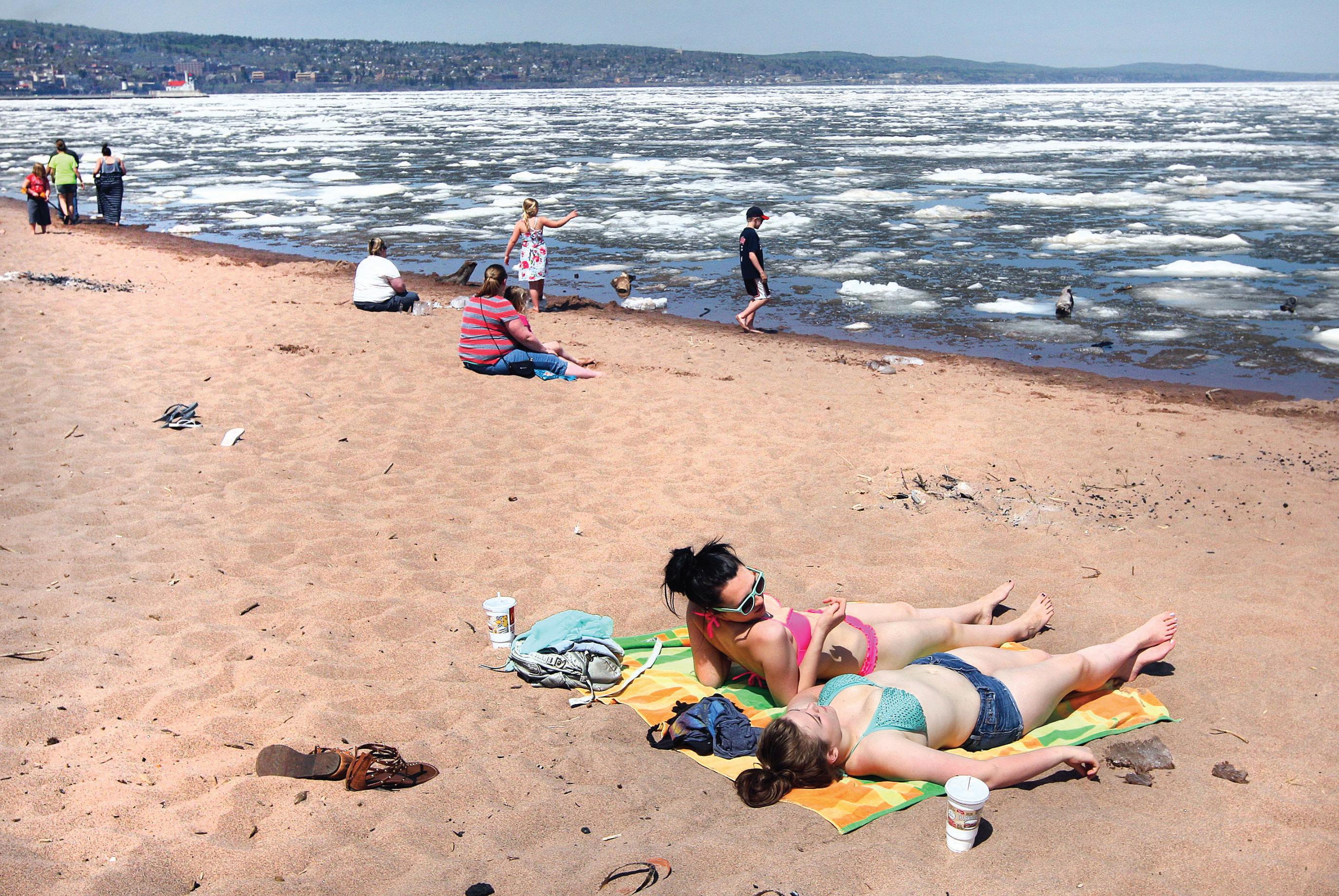
Mikayla Bergman and Ashley Fedo, both of Duluth, came down to the icy shore of Lake Superior on Park Point on May 23, 2014 -- over the Memorial Day weekend -- to get some sun while Lake Superior ice still lingered along the Duluth and Superior shorelines. (Bob King / rking@duluthnews.com)
Hurley resident Kathy Lantta walks her dog, Angel, amid snowbanks that almost cover street signs on Jan. 31, 1997, during a season in which the community saw nearly 300 inches of snow. (News Tribune file photo)
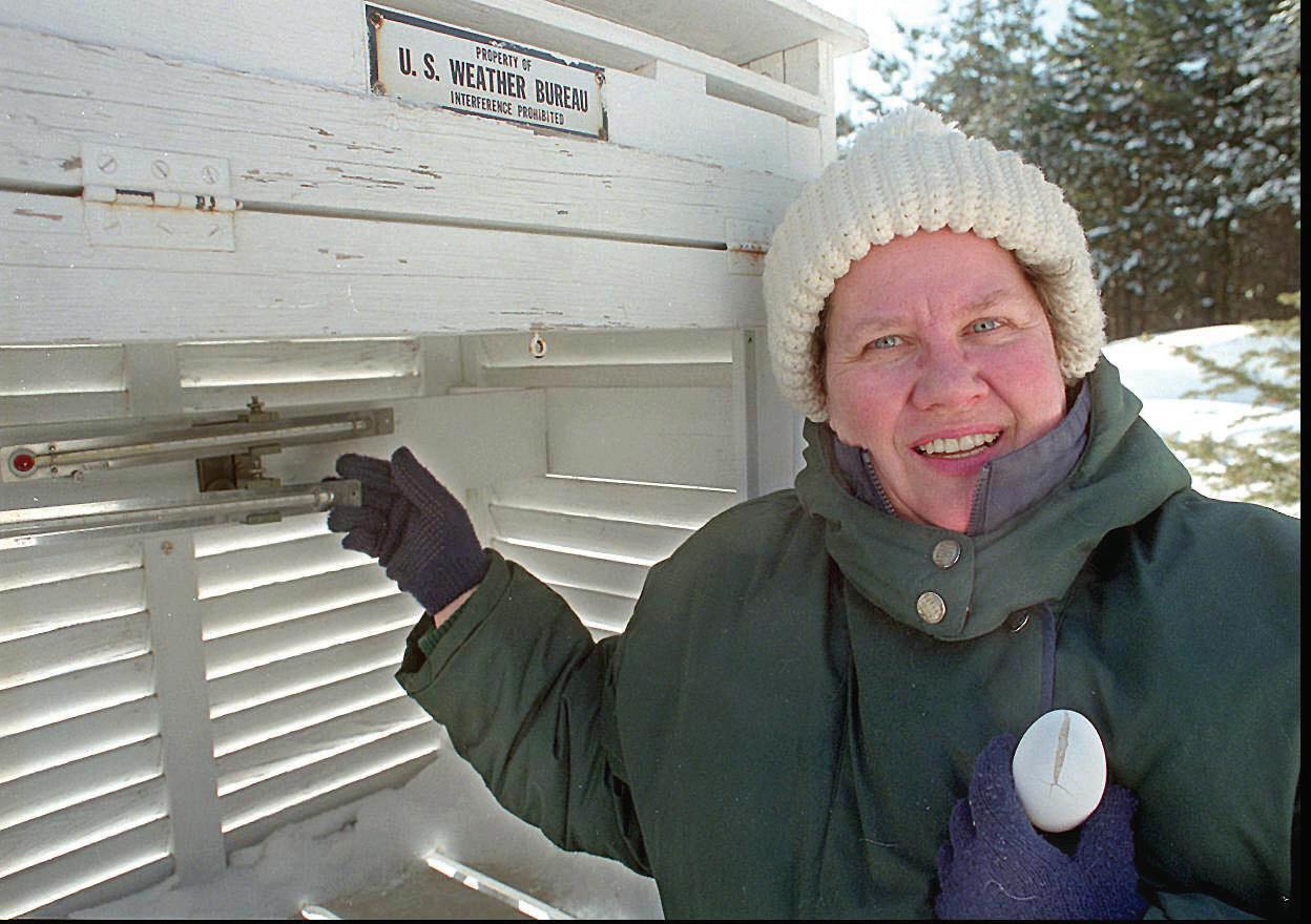
Kathy Hoppa of rural Tower poses for a photo at her weather station where she recorded the new record low temperature for the state -- 60 below zero -- on Feb. 2, 1996. She’s holding an egg she tucked inside the weather station Thursday night to see if it would freeze. It was frozen solid Friday morning and she used it to play ball with her friends. (Bob King / rking@duluthnews.com)
NORTHLAND WEATHER ALMANAC
Duluth weather statistics by month
JANUARY
Record high: 55 — Jan. 23, 1942 (most recent)
Record low: 41 below zero — Jan. 2, 1885
Average high: 19
Average low: 2
Average precipitation: 0.96”
Average snowfall: 19.4”
FEBRUARY
Record high: 58 — Feb. 26, 1895
Record low: 39 below zero — Feb. 2, 1996
Average high: 24
Average low: 6
Average precipitation: 0.81”
Average snowfall: 12.4”
MARCH
Record high: 81 — March 28, 1946
Record low: 29 below zero — March 2, 1989
Average high: 34
Average low: 18
Average precipitation: 1.49”
Average snowfall: 13.2”
APRIL
Record high: 88 — April 27, 1952
Record low: 5 below zero — April 4, 1975 (most recent)
Average high: 49
Average low: 30
Average precipitation: 2.43”
Average snowfall: 6.9”
MAY
Record high: 95 — May 30, 1939
Record low: 16 — May 3, 1907
Average high: 62
Average low: 41
Average precipitation: 3.23”
Average snowfall: 0.4”
JUNE
Record high: 97 — June 28, 1910
Record low: 27 — June 10, 1972
Average high: 71
Average low: 49
Average precipitation: 4.23”
JULY
Record high: 106 — July 13, 1936
Record low: 35 — July 1, 1988
Average high: 76
Average low: 55
Average precipitation: 3.85”
AUGUST
Record high: 97 — Aug. 5, 1947 (most recent)
Record low: 32 — Aug. 27, 1986
Average high: 74
Average low: 54
Average precipitation: 3.7”
SEPTEMBER
Record high: 95 — Sept. 7. 1976
Record low: 22 — Sept. 28, 1942
Average high: 65
Average low: 46
Average precipitation: 4.11”
OCTOBER
Record high: 86 — Oct. 2, 1953
Record low: 6 — Oct. 27, 1917
Average high: 52
Average low: 35
Average precipitation: 2.85”
Average snowfall: 2.3”
NOVEMBER
Record high: 73 — Nov. 3, 1903
Record low: 29 below zero — Nov. 29, 1875
Average high: 36
Average low: 22
Average precipitation: 2.09”
Average snowfall: 13.7”
DECEMBER
Record high: 56 — Dec. 6, 1939
Record low: 35 below zero — Dec. 28, 1917
Average high: 22
Average low: 7
Average precipitation: 1.21”
Average snowfall: 17.7”
Source: National Weather Service
October 2017 • DNT Extra 37
NORTHLAND WEATHER ALMANAC
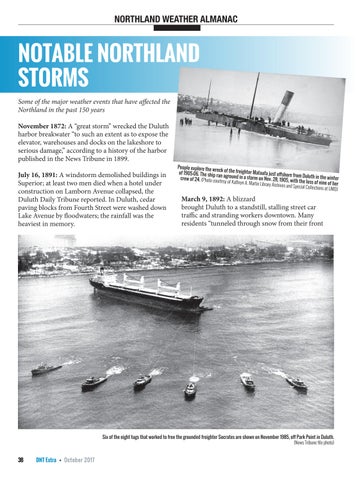
NOTABLE NORTHLAND STORMS

Some of the major weather events that have affected the Northland in the past 150 years
November 1872: A “great storm” wrecked the Duluth harbor breakwater “to such an extent as to expose the elevator, warehouses and docks on the lakeshore to serious damage,” according to a history of the harbor published in the News Tribune in 1899.

July 16, 1891: A windstorm demolished buildings in Superior; at least two men died when a hotel under construction on Lamborn Avenue collapsed, the Duluth Daily Tribune reported. In Duluth, cedar paving blocks from Fourth Street were washed down Lake Avenue by floodwaters; the rainfall was the heaviest in memory.
March 9, 1892: A blizzard brought Duluth to a standstill, stalling street car traffic and stranding workers downtown. Many residents “tunneled through snow from their front
38 DNT Extra • October 2017
Six of the eight tugs that worked to free the grounded freighter Socrates are shown on November 1985, off Park Point in Duluth. (News Tribune file photo)
People explore the wreck of the freighter Mataafa just offshore from Duluth in the winter of 1905-06. The ship ran aground in a storm on Nov. 28, 1905, with the loss of nine of her crew of 24. (Photo courtesy of Kathryn A. Martin Library Archives and Special Collections at UMD)
doors to the street, and snow was piled up to the second-story windows,” the News Tribune recounted in a look back several years later.
Nov. 27-28, 1905: The “Mataafa Storm,” named for the freighter that was stranded offshore from Canal Park in Duluth with the loss of nine lives. The storm brought winds gusting to 70 mph. “Telephone, telegraph and street car communication was interrupted … and scores of persons were unable to get home,” the News Tribune reported on Nov. 28. “It is claimed by some of the old time lake men that the waves in the harbor were the highest seen in years.” Ships also were wrecked along the North Shore, and the storm spurred the construction of Split Rock Lighthouse.
July 21-22, 1909: A violent rainstorm flooded streets and homes in Duluth, and claimed the lives of two young children who were swept out of their mother’s arms as she tried to reach safety at Ninth Avenue East
and Second Street. “Floods of water poured down every avenue, making Superior Street an almost impassable river, bringing with it big timbers, paving blocks and debris,” the News Tribune reported. Water flowed into the Bijou Theater and filled the orchestra pit as the musicians scrambled to escape.

Nov. 7-11, 1913: Sometimes known as the “White Hurricane,” this massive storm produced high winds in Duluth but intensified to the east to become on of the biggest storms in Great Lakes history. Wind speeds up to 90 mph created waves 35 feet high. More than a dozen ships foundered, and about 250 sailors died. The wreck of one of those ships — the Henry B. Smith — was discovered in 2013 offshore from Marquette, Mich., by a group of shipwreck hunters with Northland ties.
March 3-5, 1935: Duluth was “practically an isolated
October 2017 • DNT Extra 39
NORTHLAND WEATHER ALMANAC
Onlookers take in the scene of a car that fell into a huge sinkhole on Skyline Parkway at Ninth Avenue East in Duluth on June 20, 2012. Storm runoff undercut the ground beneath to create the weak spot in the pavement. No one was seriously injured. (Bob King / rking@duluthnews.com)
Continued on page 40
city,” linked to the outside world only by radio, after a major ice storm cut utilities and left roads impassable. There was major tree and utility damage from Hinckley and Moose Lake, across all of Duluth and Superior and up to the Iron Range and North Shore. Utility companies reported the damage was “the worst since electricity came to Duluth,” the News Tribune reported; one transmission line was down for several miles from Nopeming into Duluth, with the mangled wires frozen together.
Nov. 11-12, 1940: The Armistice Day Blizzard arrived suddenly, bringing a sharp drop in temperatures and heavy snow that stranded hundreds of motorists and hunters in the elements across the Midwest; dozens of people died. The Northland saw heavy snow and wind but escaped the worst of the storm — though there were some Northland residents among the crews of two ships that sank with all hands on Lake Michigan.
July 16-17, 1942: Torrential rain in excess of 8 inches led to flash flooding and major damage in Bayfield, carving out deep gullies in some places and depositing vast amounts of gravel and sand elsewhere, the National Weather Service reported.
Sept. 9-10, 1947: Hibbing saw 8.6 inches of rain in five hours, flooding an estimated 75 percent of basements in town. There was flooding across the Range; U.S. Highway 169 was closed, and several mining operations saw damage.
March 26-27, 1950: As Duluth welcomed home the state basketball champion Duluth Central Trojans, a sleet and ice storm caused widespread phone and power outages and downed hundreds of utility poles.
Dec. 4-8, 1950: A winter storm brought more than 30 inches of snow to Duluth over five days; crews struggled to clear streets after about a third of the city’s snow-removal equipment broke down.

May 26, 1958: A possible tornado caused damage in Duluth, including the collapse of a garage on Greene Street in West Duluth. Athletes and spectators at the city track meet at Public Schools Stadium had to take cover. To the north, large hail caused damage in Eveleth.
Nov. 28, 1960: Winds estimated at 75 mph kicked up huge waves on Lake Superior, which sent water and debris into Canal Park. The breakwaters along the Superior Entry were damaged, stranding two Coast Guardsmen in the lighthouse there for about two days, the News Tribune reported. There also was flooding in downtown Grand Marais, and about 1,000
40 DNT Extra • October 2017 NORTHLAND WEATHER ALMANAC
A Gold Cross ambulance pushes through standing water and ice on South Lake Avenue at the Aerial Lift Bridge in Duluth during the March 1975 blizzard. (News Tribune file photo)
The canopy at the Holiday gas station at Rice Lake and Arrowhead roads in Duluth was damaged by the high winds as storms moved through on July 21, 2016. (Bob King / rking@duluthnews.com)
cords of timber stockpiled on the waterfront was washed into the harbor.
March 1-5, 1966: A prolonged winter storm caused widespread power outages over several days and brought business to a halt in downtown Duluth. The Finland Air Force Station along the North Shore was cut off for several days as plow crews struggled to cut through 15-foot drifts.

April 30, 1967: Gale-force winds sent waves crashing over the piers of the Duluth ship canal. Three teenage brothers from Duluth drowned when they were swept off the north pier; a Coast Guardsman who attempted to rescue them also died.
Aug. 6, 1969: Two people died when an F3 tornado touched down near Boulder Lake and tracked east to Two Harbors. It was part of a large outbreak of tornadoes across Minnesota that day; another one that hit the community of Outing caused 12 deaths and injured 70.
August-September
1972: On Aug. 20, 1972, Duluth saw 3 inches of rain in two hours — after what had already been a very wet summer — causing major damage to streets on the hillside. Sixth Avenue East was among the hardest-hit locations. To the west, tons of sand stockpiled for the project to connect Piedmont Avenue with Interstate 35 washed down 20th Avenue West and closed Superior Street. A month later, an early-morning storm dropped another 4 to 6 inches of rain, undoing many of the repairs from the month before and affecting more areas, including Proctor. Two people died when their car went into a washout northeast of Two Harbors. Combined, the storms caused an estimated $41 million in damage — more than $200 million in
today’s dollars.
March 23-25, 1975: A blizzard dropped more than a foot of snow and brought winds that reportedly gusted to 100 mph in Duluth, the Weather Service reported. Huge waves on Lake Superior sent debris into Canal Park, including into first-floor rooms of what was then a Holiday Inn along the shore. Interstate 35 was closed between Duluth and the Twin Cities, and waves damaged the Two Harbors municipal water plant. Another blizzard brought 12-plus inches of snow to Duluth days later — and
all of that followed another blizzard that in January had dropped close to two feet of snow to parts of the Northland.
Nov. 10, 1975: A storm that brought relatively little snow and wind to the Northland intensified as it moved over eastern Lake Superior, where it produced hurricane-force winds that hit the freighter Edmund Fitzgerald. The Fitzgerald sank with the loss of all 29 men aboard, an tragedy remembered each Nov. 10 with a memorial observance at Split Rock Lighthouse.
October 2017 • DNT Extra 41
WEATHER ALMANAC
NORTHLAND
on page 42
Cars and trucks are abandoned along Interstate 35 near Moose Lake in the wake of the March 1975 blizzard. (News Tribune file photo)
Continued
NORTHLAND WEATHER ALMANAC
March 22-23, 1991: A major ice storm hit Duluth, which combined with high winds to topple the 850-foot-tall WDIOTV broadcast tower — which in turn hit a power line that knocked out power to all TV and radio stations in town except for KDAL-AM. There was ice up to 6 inches thick on the wreckage after the storm passed. The storm also caused widespread tree damage across the region.
Nov. 20, 1982: A late-autumn rainstorm combined with melting snow to cause flooding in the Twin Ports. Tischer, Miller and Keene creeks left their banks; floodwaters surrounded the Irving Recreation Center.
March 3-4, 1985: A blizzard brought wind gusts in excess of 90 mph to Duluth, created drifts in excess of 20 feet on Park Point and shut down the freeways and bridges in the Twin Ports at times.
Nov. 18, 1985: Winds gusting to near 70 mph pushed the anchored 585-foot freighter Socrates onto the beach of Park Point, where it remained stuck in the sand just offshore for nearly a week and became a tourist attraction of sorts until it was freed with the help of eight tugboats.
June 21, 1986: Hours after Grandma’s Marathon, a violent storm moved through the Twin Ports with winds in excess of 80 mph. It downed trees and power lines, flipped planes at Sky Harbor Airport and broke the moorings of six mothballed or derelict freighters around the harbor. One — the Joshua A. Hatfield — was blown across Superior Bay and went aground on the harbor side of Park Point.
Oct. 31-Nov. 3, 1991: Halloween blizzard dropped more than 3 feet of snow on Duluth and brought travel to a near-standstill across the city and region. Read more about it on page 26.
July 4, 1999: A windstorm known as a derecho swept across the Boundary Waters Canoe Area Wilderness with winds estimated at 80-100 mph, downing millions of trees. Several dozen campers were injured — but, miraculously, no one was killed. The downed trees created an immense amount of potential fuel for wildfires — a danger that persists to this day.

June 18, 2001: An F3 tornado touched down in Burnett County, causing severe damage in the community of Siren. Three people died, and more than a dozen were injured.
March 1-2, 2007: Widespread snowfall of 20 or more inches and winds in excess of 60 mph hit Duluth and the Northland. Snow fell at a rate of 2 inches per hour at times, and was accompanied by thunder and lightning. Plows were pulled from the roads at the height of the blizzard, and access to Park Point was cut off. Earlier that same week, another storm had dropped about 18 inches of snow on Duluth.
42 DNT Extra • October 2017
Damage caused to Wisconsin Highway 13 by the floodwaters of Trout Brook is seen on July 12, 2016, near North York south of Ashland. (Steve Kuchera / skuchera@duluthnews.com)
NORTHLAND WEATHER ALMANAC
April 5-7, 2008: A persistent band of heavy snow dropped as much as 32 inches just north of Virginia — possibly the greatest April snow event in state history.
June 6, 2008: A half-foot of rain in a short amount of time caused flash flooding in Grand Marais and elsewhere in Cook County, washing out roads and flooding basements.
March 23-25, 2009: Steady rain and temperatures just below freezing combined for a major ice storm on parts of the North Shore, including the Silver Bay and Finland areas. Tens of thousands of trees snapped under the weight of more than an inch of ice.
Dec. 24-26, 2009: Just in time for Christmas, Mother Nature brought 2 feet of heavy, wet snow to the Twin Ports and winds to 55 mph.
June 19-20, 2012: Six to 10 inches of rain fell on top of already-saturated ground in the Twin Ports, leading to widespread, catastrophic flooding. There was flash flooding in Duluth, Superior and surrounding communities, and a longer-duration flood event in the Moose Lake area. The Lake Superior Zoo suffered major damage and the death of some animals, and major roadways — including Interstate 35 — were closed for a time. Damage reached the millions of dollars — but no people died or were seriously injured.
March-April 2013: After Duluth started the winter with belowaverage snowfall, the city saw 25.5 inches of snow in March — double the normal amount. Then, in April, the Duluth airport received 50.8 inches of snow — the most ever recorded in a single month in the city’s history. Cross-country skiers were out on the Birkebeiner trail near Hayward into May, but the extended winter wreaked havoc on spring sports, gardens and the fishing opener. The season total was 129.4 inches of snow
— surpassed by the next season’s 130.2 inches. The record for Duluth remains 135.4 inches, in 1995-96.
July 11-12, 2016: Three people died after storms with torrential rainfall caused major flooding in Northwestern Wisconsin and parts of Carlton and Pine counties, including more than $10 million in damage at Saxon Harbor along Lake Superior.
July 21, 2016: A line of storms brought winds that may have exceeded 100 mph in the Duluth area, causing widespread damage to trees, buildings and power lines. Some homes were without power for days. The same storms claimed the lives of two campers in Quetico Provincial Park, and caused major damage in Hill City and Ely. It was the largest of several damaging windstorms to affect the region that summer.
— Compiled by Andrew Krueger, akrueger@ duluthnews.com. Sources: News Tribune archives; National Weather Service; “Minnesota Weather Almanac” by Mark Seeley; Minnesota Department of Natural Resources; Minnesota State Climatology Office

October 2017 • DNT Extra 43
Damage on Sixth Avenue East in Duluth after the major flooding of August 1972. (News Tribune file photo)