
5 minute read
from A(lberta clipper) to W(ind chill)


By John Lundy jlundy@duluthnews.com
Polar vortex. Thundersnow. Alberta clipper. Saskatchewan screamer. Panhandle hook.
Weather in the Northland offers a vocabulary of its own.
To help sort through the verbiage, the News Tribune turned to Carol Christenson, warning coordination meteorologist at the National Weather Service in Duluth. She’s the primary source for all of the definitions that follow.
Alberta clipper — A low-pressure system that originates in the Canadian province of Alberta and enters the United States. “If it’s an Alberta clipper, we can usually count on 1 to 3 inches of snow,” Christenson said. “They’re fast-moving, so they don’t hang around a long time.”
Black ice — Clear ice on roadways. It can form after a “warmish” day during which snow or frost on the roads has melted and then frozen again. “It catches motorists unaware,” Christenson said.
Blizzard — Either falling snow or snow that already has fallen being whipped by very strong winds, creating dangerously low visibility. For the National Weather Service to describe a storm as a blizzard, winds must be at least 35 mph (sustained or frequent gusts) and visibility must be a quarter-mile or less.
True blizzards occur infrequently in the Northland “because we are so well-forested,” Christenson said. Sometimes, meteorologists will use the term “blizzardlike conditions” to get across the idea that it’s a dangerous storm, even if it’s not technically a blizzard.
Colder by the lake
— “The lake breeze has kicked in, causing cold air off Lake Superior to come inland and force us to put on sweatshirts in July,” Christenson said. It’s most common in late spring or early summer when the lake is still especially cold.
El Nino — It’s when the waters along the Peruvian coast of the South Pacific warm considerably, causing major changes in the global wind circulation system. It occurs naturally about every seven years. It results in a warmer winter.
Flurry — Snow that doesn’t accumulate and doesn’t affect visibility.
Ice fog — Fog that occurs when it’s below freezing. It can produce black ice.
Ice jam — It occurs when ice on a river breaks up but congregates in an area of the river, such as at a bend. That can cause the water to back up and create flooding.
Ice storm warning — It’s issued when the National Weather Service expects freezing rain to accumulate to over ¼ inch on surfaces.
Lake breeze — It occurs when the temperature difference between the land and the lake surface increases to the point where lake air rushes in to take the place of warm air that has been rising from the land. See “colder by the lake.”

Lake-effect snow — It occurs when very cold air flows over the warmer water of Lake Superior. It’s light and fluffy. “Sometimes we call it ‘movie snow,’ ” Christenson said. But it accumulates rapidly. In this region, it occurs most frequently across northern Wisconsin and the Upper Peninsula, because the winds that produce lake effect are usually from the north or northwest. But lake-effect snow can occur in Duluth and along the North Shore.
La Nina — It’s when the waters off the Peruvian coast become significantly colder. It can produce a colder winter in the Northland, but the effect of a La Nina isn’t as reliable as the effect of an El Nino.
Models — Forecasts are derived using various computerized forecast “models.” They are determined by taking data from the atmosphere and plugging the numbers into a mathematical equation. But different models use different equations and different atmospheric measures. “They all have their uses and their faults, and it’s up to us to try to figure out which model or which blend of models we may want to use,” Christenson said.
November gale — A gale occurs when a strong low-pressure system moves north out of the Southern Plains and creates extremely strong northeast winds on Lake Superior, causing tremendous waves. The Mataafa storm of 1905 and the storm that led to the sinking of the Edmund Fitzgerald in 1975 both were November gales. Gales can occur at other times of the year, but they happen most frequently during transitional months, such as November and April. That is when temperature differences between the North and South are the greatest.
Panhandle hook — This happens when a lowpressure system develops in the Panhandle area of Oklahoma and Texas. Fueled by Gulf of Mexico waters, it moves northeast across the Upper Midwest and produces tremendous amounts of snow — somewhere. “They’re not rare, but to actually hit us we might get a good one or two a season,” Christenson said. When it hits directly, it can produce around a foot of wet, heavy snow.
Polar vortex — It’s a permanent low-pressure system located at the North Pole and the South Pole. “It’s always there,” Christenson said. “It’s nothing new.” But we hear more about it some winters. “Sometimes the cold air associated with the polar vortex comes down into our area causing … what we call an arctic outbreak,” she said.
Saskatchewan screamer — It’s exactly like an Alberta clipper, except it originates in Saskatchewan. Drier Canadian air is one reason neither the clipper nor the screamer brings a lot of snow.
Sea smoke — It occurs when arctic air blows across the warm waters of Lake Superior. The warm air cools and condenses, forming fog, which many refer to as sea smoke.
Slush — Very wet snow. “It’s the kind of snow that just grabs your tires and drags you into the ditch,” Christenson said.
Snowburst — Heavy snowfall that greatly reduces visibility but occurs for a very short period of time.

It could be due to lake effect or caused by a front generating in the immediate area.
Thundersnow — It goes hand in hand with a snowburst. When “frontal genesis” occurs — which means a front is forming right over you — you can easily get thundersnow. Snowbursts and thundersnow tend to occur with southerly winds that cause warmer conditions and bring lots of moisture into the area.
Trough — A low-pressure system. The Weather Service uses the term when the system doesn’t have a specific center and isn’t closed off in in a circular way. A trough is a weaker system, but it marks a separation between two weather systems, and its effect can be powerful. Depending on various factors, it can produce a lot of precipitation. Troughs occur frequently.
Upper level disturbance — When a trough is aloft, it causes an upper level disturbance, characterized by spinning wind. “That can cause tremendous amounts of weather changes,” Christenson said.
Warmer by the lake — In winter and fall, it’s usually warmer by the lake because while inland areas cool off quickly, it takes a long time for water to cool down. So the water eventually becomes warmer than the land and keeps areas close to Lake Superior warmer.
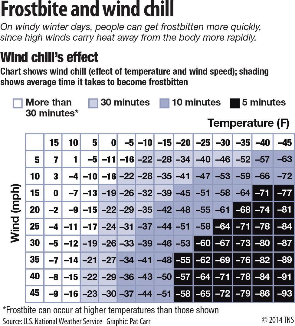
Wind chill warning — Cold conditions combined with wind causes us to lose body heat more quickly. A warning is issued when the wind chill is expected to be below -40F.
Winter storm warning — When a storm is close and forecasters have more confidence that it will form, a warning is issued. “We like to give some lead time,” Christenson said. “It depends on our confidence level.” A warning is issued when the forecast calls for 6 inches or more of snow within 12 hours, 8 inches or more of snow within 24 hours, or a mixture of snow, freezing rain, sleet and wind.
Winter storm watch — A watch is used when forecasters see that atmospheric conditions could form a winter storm. A watch is issued up to 36 hours before the expected arrival of a storm. u


