3 minute read
NORTHLAND WEATHER ALMANAC


March 22-23, 1991: A major ice storm hit Duluth, which combined with high winds to topple the 850-foot-tall WDIOTV broadcast tower — which in turn hit a power line that knocked out power to all TV and radio stations in town except for KDAL-AM. There was ice up to 6 inches thick on the wreckage after the storm passed. The storm also caused widespread tree damage across the region.
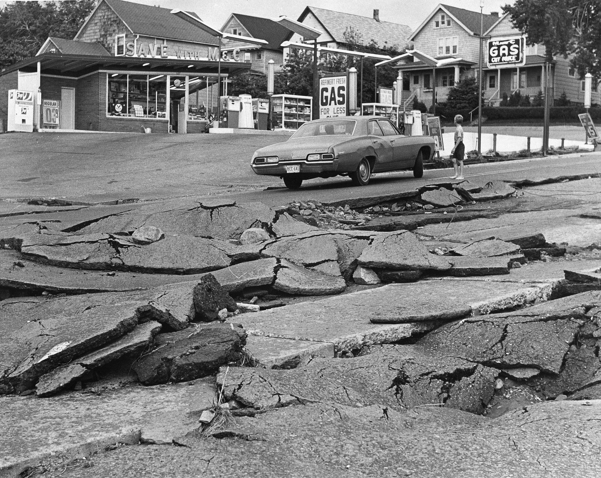
Nov. 20, 1982: A late-autumn rainstorm combined with melting snow to cause flooding in the Twin Ports. Tischer, Miller and Keene creeks left their banks; floodwaters surrounded the Irving Recreation Center.
March 3-4, 1985: A blizzard brought wind gusts in excess of 90 mph to Duluth, created drifts in excess of 20 feet on Park Point and shut down the freeways and bridges in the Twin Ports at times.
Nov. 18, 1985: Winds gusting to near 70 mph pushed the anchored 585-foot freighter Socrates onto the beach of Park Point, where it remained stuck in the sand just offshore for nearly a week and became a tourist attraction of sorts until it was freed with the help of eight tugboats.
June 21, 1986: Hours after Grandma’s Marathon, a violent storm moved through the Twin Ports with winds in excess of 80 mph. It downed trees and power lines, flipped planes at Sky Harbor Airport and broke the moorings of six mothballed or derelict freighters around the harbor. One — the Joshua A. Hatfield — was blown across Superior Bay and went aground on the harbor side of Park Point.
Oct. 31-Nov. 3, 1991: Halloween blizzard dropped more than 3 feet of snow on Duluth and brought travel to a near-standstill across the city and region. Read more about it on page 26.
July 4, 1999: A windstorm known as a derecho swept across the Boundary Waters Canoe Area Wilderness with winds estimated at 80-100 mph, downing millions of trees. Several dozen campers were injured — but, miraculously, no one was killed. The downed trees created an immense amount of potential fuel for wildfires — a danger that persists to this day.
June 18, 2001: An F3 tornado touched down in Burnett County, causing severe damage in the community of Siren. Three people died, and more than a dozen were injured.
March 1-2, 2007: Widespread snowfall of 20 or more inches and winds in excess of 60 mph hit Duluth and the Northland. Snow fell at a rate of 2 inches per hour at times, and was accompanied by thunder and lightning. Plows were pulled from the roads at the height of the blizzard, and access to Park Point was cut off. Earlier that same week, another storm had dropped about 18 inches of snow on Duluth.
Northland Weather Almanac
April 5-7, 2008: A persistent band of heavy snow dropped as much as 32 inches just north of Virginia — possibly the greatest April snow event in state history.
June 6, 2008: A half-foot of rain in a short amount of time caused flash flooding in Grand Marais and elsewhere in Cook County, washing out roads and flooding basements.
March 23-25, 2009: Steady rain and temperatures just below freezing combined for a major ice storm on parts of the North Shore, including the Silver Bay and Finland areas. Tens of thousands of trees snapped under the weight of more than an inch of ice.
Dec. 24-26, 2009: Just in time for Christmas, Mother Nature brought 2 feet of heavy, wet snow to the Twin Ports and winds to 55 mph.
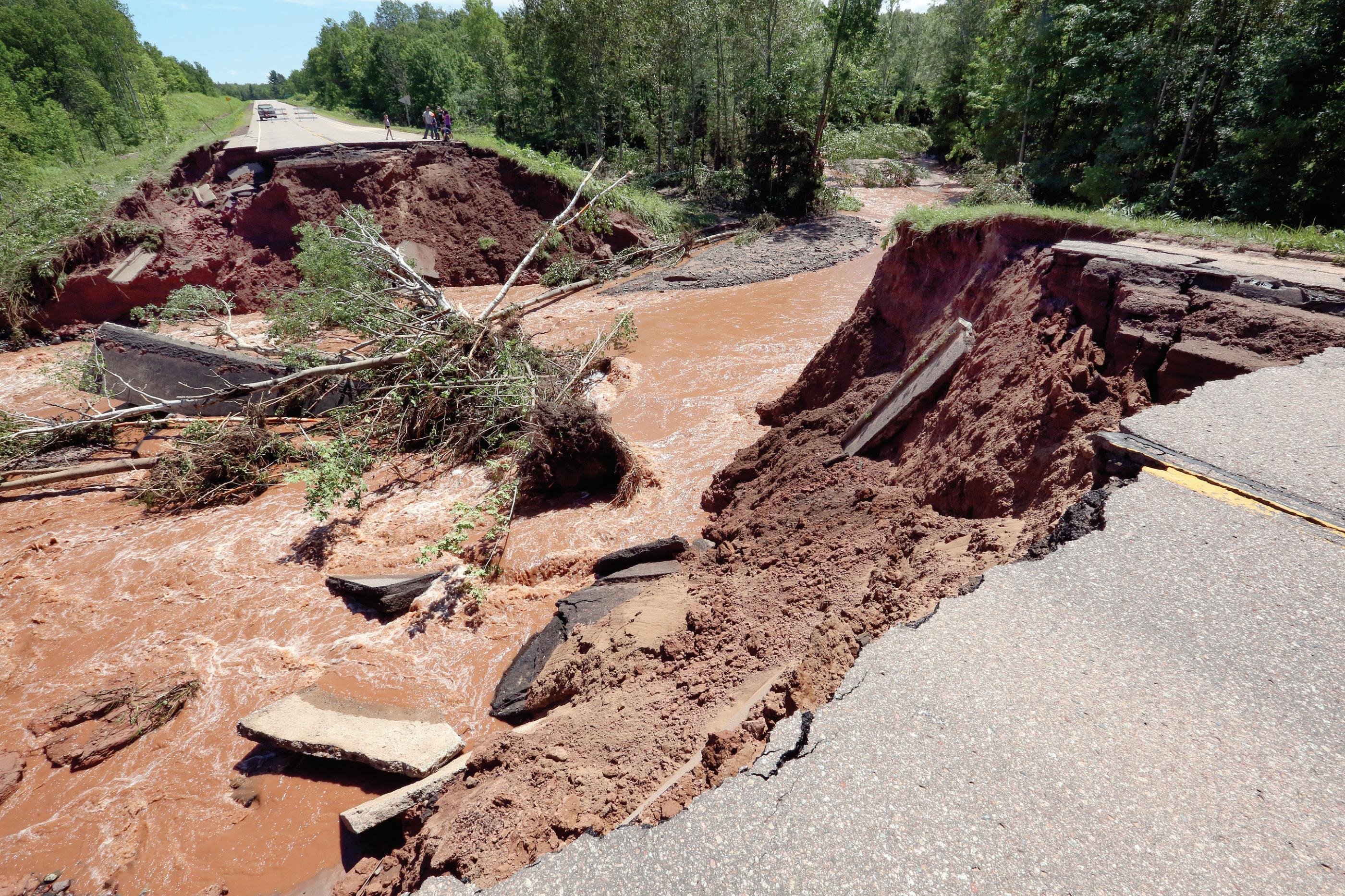
June 19-20, 2012: Six to 10 inches of rain fell on top of already-saturated ground in the Twin Ports, leading to widespread, catastrophic flooding. There was flash flooding in Duluth, Superior and surrounding communities, and a longer-duration flood event in the Moose Lake area. The Lake Superior Zoo suffered major damage and the death of some animals, and major roadways — including Interstate 35 — were closed for a time. Damage reached the millions of dollars — but no people died or were seriously injured.
March-April 2013: After Duluth started the winter with belowaverage snowfall, the city saw 25.5 inches of snow in March — double the normal amount. Then, in April, the Duluth airport received 50.8 inches of snow — the most ever recorded in a single month in the city’s history. Cross-country skiers were out on the Birkebeiner trail near Hayward into May, but the extended winter wreaked havoc on spring sports, gardens and the fishing opener. The season total was 129.4 inches of snow
— surpassed by the next season’s 130.2 inches. The record for Duluth remains 135.4 inches, in 1995-96.
July 11-12, 2016: Three people died after storms with torrential rainfall caused major flooding in Northwestern Wisconsin and parts of Carlton and Pine counties, including more than $10 million in damage at Saxon Harbor along Lake Superior.
July 21, 2016: A line of storms brought winds that may have exceeded 100 mph in the Duluth area, causing widespread damage to trees, buildings and power lines. Some homes were without power for days. The same storms claimed the lives of two campers in Quetico Provincial Park, and caused major damage in Hill City and Ely. It was the largest of several damaging windstorms to affect the region that summer.
— Compiled by Andrew Krueger, akrueger@ duluthnews.com. Sources: News Tribune archives; National Weather Service; “Minnesota Weather Almanac” by Mark Seeley; Minnesota Department of Natural Resources; Minnesota State Climatology Office