POWELL, OHIO HISTORIC SURVEY
August 2025


August 2025
Prepared for: The City of Powell
47 Hall Street Powell, Ohio 43065
Prepared By: Josh Lapp Megan Adornetto
Designing Local 20 E Broad Street, Suite 1300 Columbus, Ohio 43215

July 2025
Sponsored by:

This survey was made possible by the generous support of the following:
CITY OF POWELL
Logan Stang, Planning Director
Claudia Husak, Planning Manager
Jeffrey Tyler, Assistant City Manager
HISTORIC DOWNTOWN ADVISORY COMMISSION
Tom Coffey, Chair
Larry Coolidge, Vice-chair
Kurt Ramsey
Andrew Lorenz
James Strunck
POWELL- LIBERTY HISTORICAL SOCIETY
A special thanks to Tom Coffey, the President of the Powell-Liberty Historical Society, and Sherry Carmichael, for taking the time to share their knowledge and for assisting with the research for historical context.
STAKEHOLDERS
A special thanks to the numerous stakeholders and community members that participated in the survey process.
CONSULTANT TEAM
Designing Local Josh Lapp
Megan Adornetto


The Powell Historic District Survey, spearheaded by the City of Powell, began in the later part of the year in 2024. The City of Powell contracted Designing Local, a woman-owned planning and design firm based in Columbus, Ohio, to conduct a survey of 80 properties within a boundary specified by the City. The primary goal of this survey was to determine if the project area could be designated as a historic district. Another goal was to create practical policy recommendations for the City. These recommendations focus on helping eligible historic properties get access to grants and tax credits in an effort to promote the protection and preservation of Powell’s historic and cultural resources. Funding for this project came from the City of Powell’s operating budget. These funds are specifically set aside for contracting services that support various planning department projects.
Powell has a deep appreciation for its history and is proactive in making improvements and advancements in its historic preservation efforts. The City took the initiative to update its Zoning Code, and with that, look into any relevant historic preservation policy or relevant efforts listed in the code. The City anticipates that a historic survey will inform and enhance its preservation policies and initiatives. This includes the ongoing development of Design Guidelines for the district, ultimately ensuring that Historic Downtown Powell’s future respects its historical essence and character. The building inventory documented in this survey will help the City better understand the characteristics of the district and therefore be better equipped to make the best decisions for the Historic Downtown moving forward.
A historic survey is the investigation and documentation of these significant pieces of architecture. Documentation methods include photo documentation, sketches, field notes, and conducting historical research into a specific property or neighborhood. Historic resources are aspects of architecture that are valued or are a significant representation of a culture or community’s history. These resources can be tangible things, such as buildings, landscapes, sites, structures, objects, or districts, or they can be intangible, such as cultural practices like art, music, and religion. Historic resource surveys are often undertaken to not only identify and create an inventory of historic properties and resources within an area, but also to provide insight into a community’s past, answer questions about a community’s history and development, and to also identify the significant sub-sections of a neighborhood to determine boundaries for historic districts.
KICK OFF: November 2024 with participants from the City of Powell and Designing Local.
SURVEY AREA TOUR: December 2024 with Designing Local, Powell City Staff members, and members of the Powell Historic Downtown Advisory Committee
FIELD DOCUMENTATION: occurred between January 30th and 31st, 2025
INITIAL FINDINGS PRESENTATION: June 3, 2025, the initial survey findings were presented to the Powell Development Committee by Designing Local project manager Megan Adornetto.
FINAL REPORT: Delivered to the City of Powell in July 2025


The goal of this survey was to identify and inventory properties built in 1975 or earlier, meeting the minimum 50 year age requirement, in Historic Downtown Powell using intensive-level survey methods to determine a period of significance and ultimately draw a historic district boundary line to advance the preservation goals of the City of Powell. The number of properties to be surveyed was determined by the following factors:
• criteria set forth by the National Park Service and the Ohio State Historic Preservation Office’s Historic Inventory standardized process;
• field observations;
• historic and current photographs; and
• research through the Powell-Liberty Historical Society
In all, eighty (80) properties were surveyed and inventoried using the Ohio Historic Inventory forms. Most of the buildings are single family homes, but retail & restaurant buildings, office buildings, city buildings, church structures, farm buildings, a museum and school building were also documented.
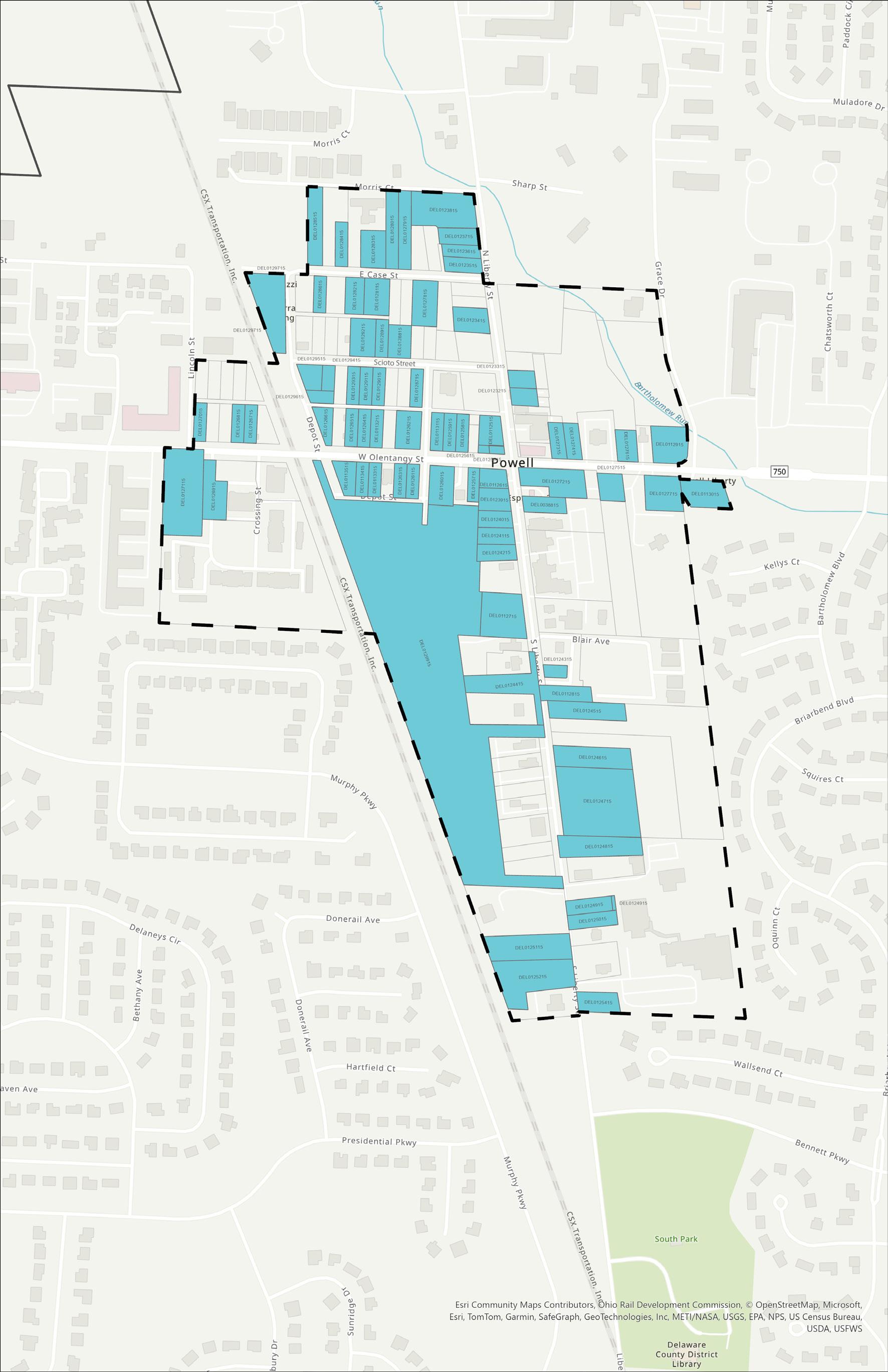
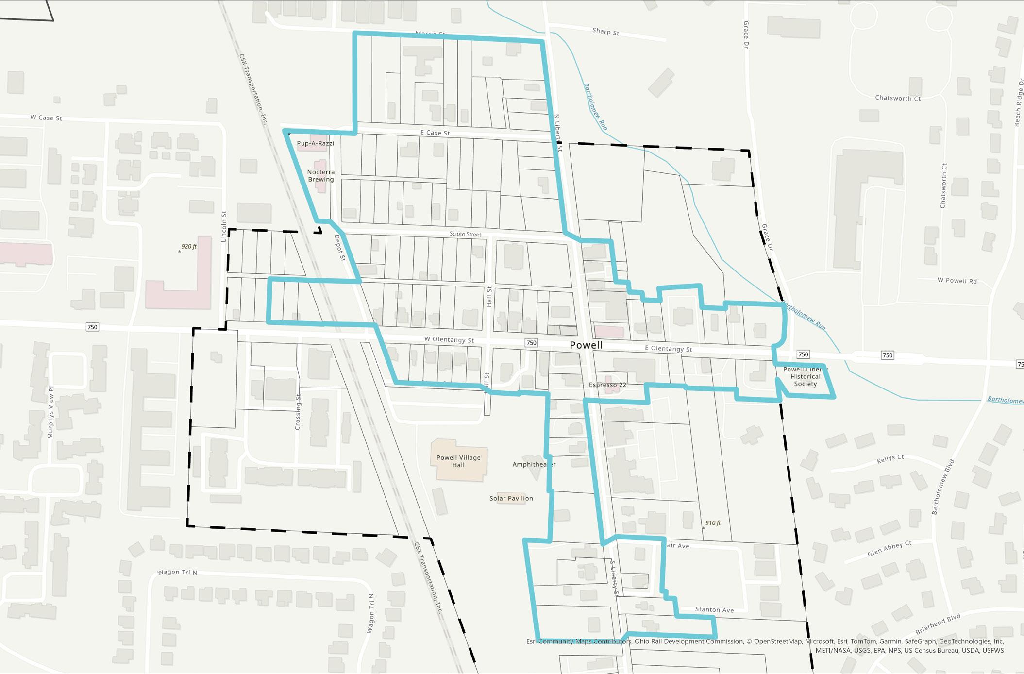
The boundary surveyed included approximately 132.5 acres of land, as identified in Figure 1 on the next page. The survey area included properties within the following areas:
• the City’s Downtown District overlay, including both the Downtown Business and Downtown Residential Districts, as defined by the City’s Zoning Code;
• the property known as the Bennett Farm, located approximately 0.5 miles from the Liberty StreetOlentangy Road intersection;
• On the east side of the Downtown District, the project boundary was adjusted to align with Grace Drive;
• On the west side, the project boundary was adjusted to align with Lincoln Street; and
• To the north, properties on Morris Court and Encore Park Bend were excluded.
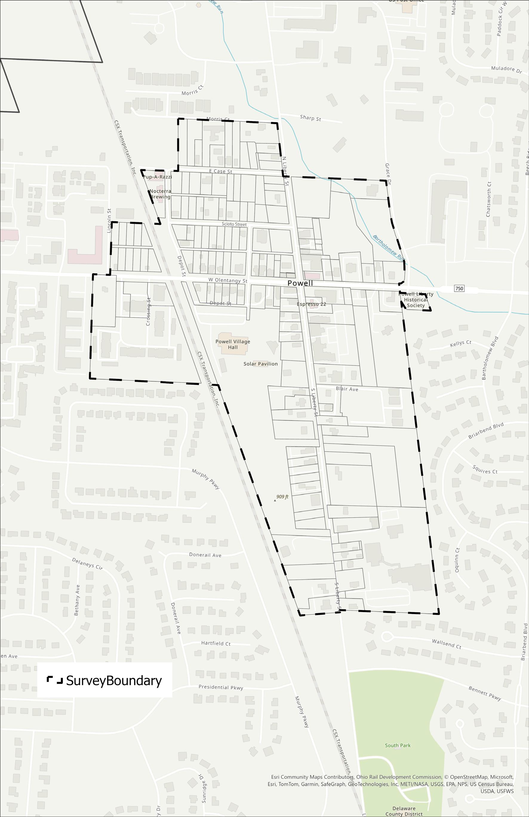
Survey Area Boundary
The Powell-Liberty Historical Society (PLHS) has amassed a collection of photographs, reports, oral histories, diaries, articles, and artifacts for reference. To support the Historic Survey, this collection was reviewed with the help of volunteers at PLHS as well as the digitized portion of their collection on their website. Maps and newspaper articles were used to fill in any research gaps. There were several properties that did not have much written information, and assistance in the researching of these properties came from Sherry Carmichael, Secretary and Statutory Agent of the PLHS.
The field survey was conducted by Historic Preservationist and Project Manager, Megan Adornetto, over the course of two days in January 2025. Each resource was approached by foot where multiple photographs were taken of each building at different angles from the public right of way. Due to the convenient and close proximity between the project team and the project area, field notes were taken and the team returned to the project area in the chance that observations needed to be confirmed.

The City of Powell is located approximately 16 miles northwest of Downtown Columbus, Ohio, just outside the I-270 Interstate Highway. Powell is situated between the Scioto River to the west and the Olentangy River to the east. The placement of the town during its first settlement in the middle of the two rivers allowed for easier transportation from what is now Downtown Columbus at a time when the most common mode of transportation was waterways and horses, before rail transportation was available. The Bartholomew Run creek runs through the eastern portion of the project area, next to the MartinPerry House on East Olentangy Road. The land between the two rivers sits elevated above the water in a forested area that had been cleared out to establish the downtown business and residential districts. A healthy tree canopy still remains in some areas more so than others, especially along either side of the railroad line.
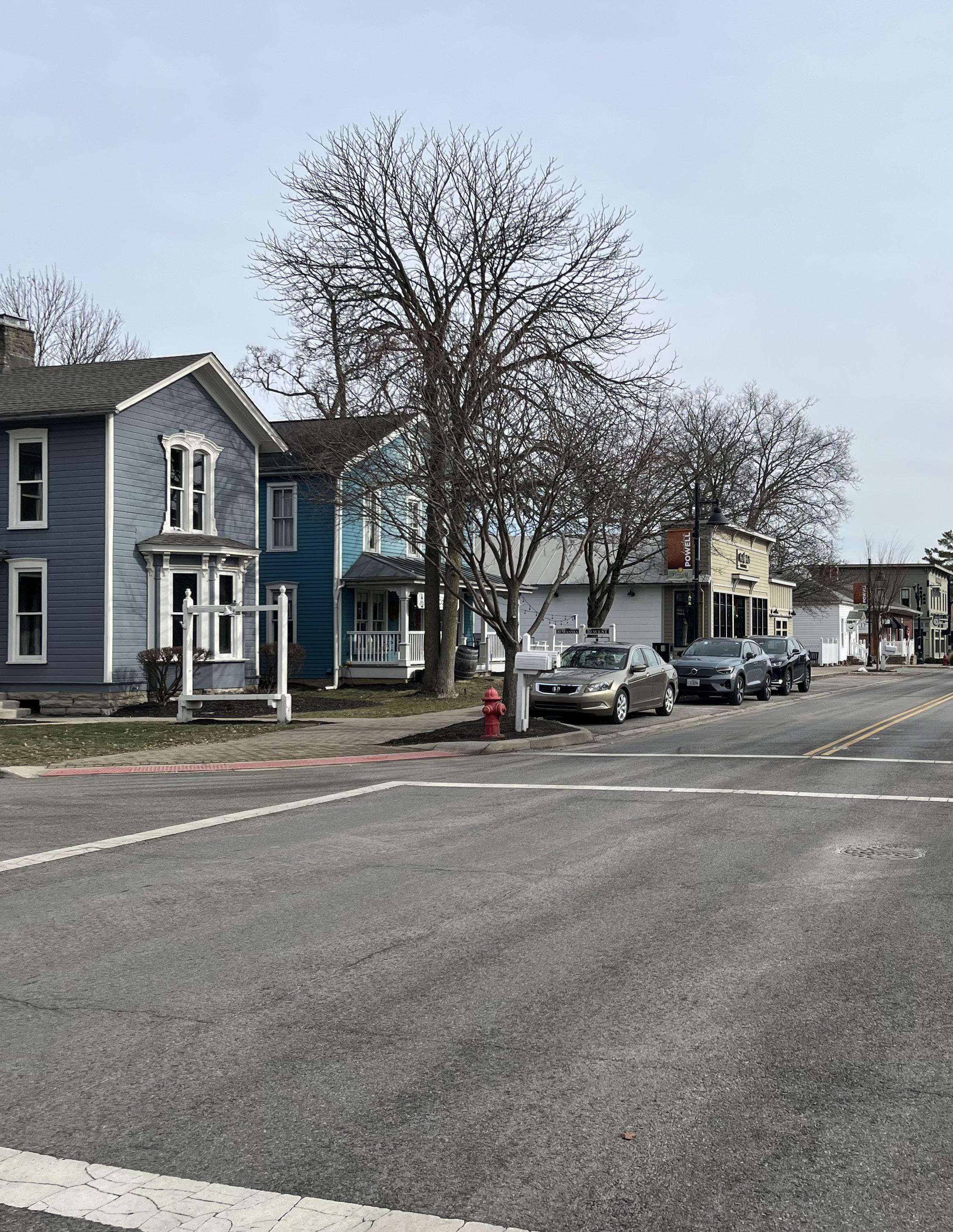
The buildings that are commercial in nature have less green space on their lot, and any open space on their parcel is used for parking on gravel or paved concrete parking lots. The buildings that are residential in nature, especially those on Scioto Street and Case Ave, have much more green space, trees, and opportunities for landscaping and planting than the others.
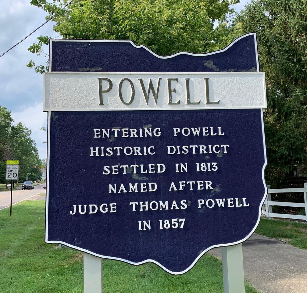
Thoughtfully-planned streetscapes can be found on West Olentangy from the railroad tracks to the intersection, on North Liberty from 15 N Liberty to the intersection, and on South Liberty from 50 South Liberty to the intersection. This streetscape is made of manicured brick sidewalks, City branded trash receptacles and benches, and styled streetlights with attached banners. On Depot Street, Scioto Street, and Case Avenue, there is no real developed streetscape. No sidewalks are found on these streets, and the area is much more quiet with more trees, plantings, and green space. The banners on the light posts in the commercial area of Powell are seasonal, but more often than not, they display the City’s branding. On the parcel for 173 West Olentangy Street is also a sign indicating the entry into the Powell Historic District. The sign says:
“Entering Powell Historic District Settled in 1813, Named after Judge Thomas Powell in 1857.”
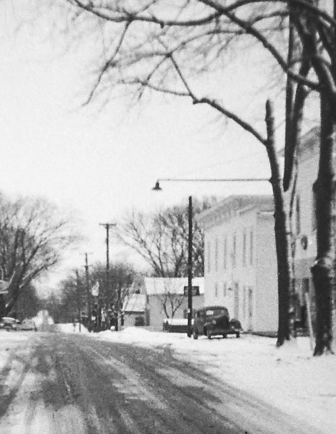
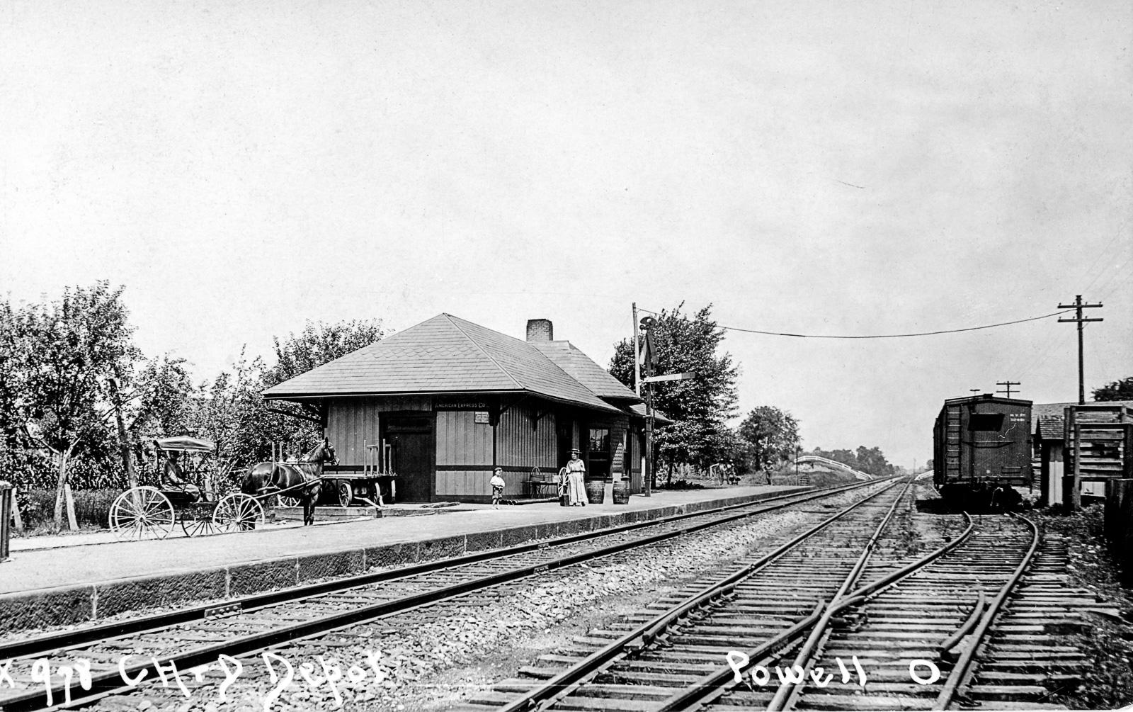
The railroad track that runs to the west portion of the survey area used to be a part of the Columbus and Hocking Valley Railway that connected Athens, Ohio to Columbus, and then to Toledo. This portion of the railway was founded 1867 with the first train arriving outside Columbus in 1868, and was intended to transport salt, coal, and brick out of the region surrounding Nelsonville, Ohio. The rail line was later expanded then continued north through Columbus along the west side of town to connect central Ohio with Toledo and Lake Erie, and to the south connecting with Pomeroy and Gallipois on the Ohio River. Full service trips carried passengers from Athens to Canal Winchester in 1868 and the first freight train arrived in Columbus in 1869. The railway was eventually renamed the Columbus, Hocking Valley and Toledo Railway in 1881. It was renamed to the Hocking Valley Railway in 1899.
The portion of this train line that runs through Powell was completed in 1877. The City built a train depot on the west side of the track, just north of what is West Olentangy Road today. Eventually, the depot was discontinued in 1961, and it was demolished by the end of the 1960s. The railroad is still operational as a part of the CSX system, moving freight throughout the midwest.
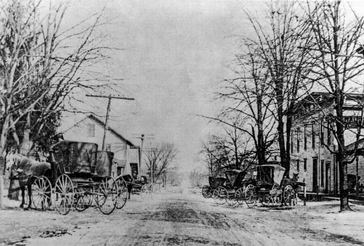
The project area has two primary thoroughfares. The street that runs north-south is Liberty street, and the one that runs east-west is Olentangy Street. A short street runs parallel to the railroad tracks on the north side of West Olentangy Street that is called Depot Street. The short side street about halfway between the railroad and Liberty Street on the south side of West Olentangy Street is Hall Street, and terminates into Powell City Hall. Scioto Street and Case Avenue run parallel to West Olentangy Streets and stretch between Depot Street and North Liberty Street.
The earliest settlers arrived in what is now Powell in the early 1800s. These settlers, most of whom came from the east coast in Connecticut, named their new home Middlebury, in honor of their hometown Middlebury, Connecticut. A land tract of 4000 acres was given to James Parker to satisfy warrants for military service in 1800. In 1805, James Parker transferred the land to James Kilbourne of Worthington. In 1806, Kilbourne sold the land to the Union Land Company, who then divided the land among its members. Five hundred (500) acres of that land was sold by Union Land Company member Samuel Scott back to James Parker. In June 1839, the land passed from Parker to Able Dixon, and then again in July passed from Dixon to Thomas R. Hall, whose family owned the land for many years after. The center of their settlement had a street that ran east and west, and another that ran north and south, which they named Middlebury Street, also in honor of their hometown. Some of the prominent early settlers included Thomas R. Hall, Captain Timothy Andrews, Joseph M. Gardner, and Ebenezer Goodrich, among others.
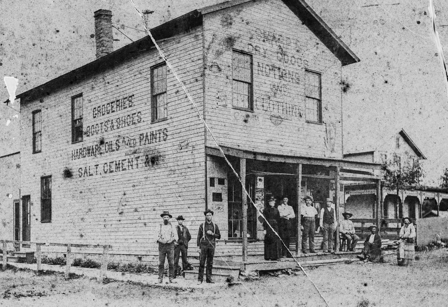
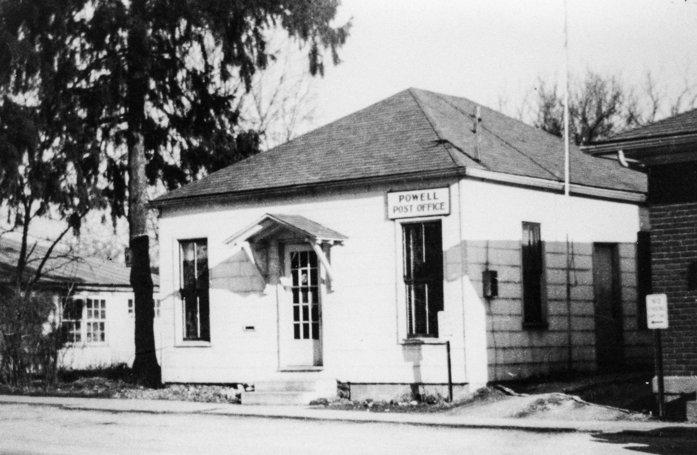
Thomas R. Hall owned the land at the center of town at Middlebury Street and opened a small store around 1850. This area became known as Hall’s Corner, the same area of the primary intersection of Historic Downtown Powell. Hall’s store received mail delivered to the residents from Lewis Center until Judge Thomas Powell petitioned the local government for a Post Office in 1857. In an effort to thank the Judge for his efforts in bringing the Post Office to town, the town changed its name to “Powell” in 1876.
◀ THE SHARP FAMILY’S DRYGOODS STORE. THIS BUILDING HAS SINCE BEEN DEMOLISHED, BUT THE BUILDING BEYOND IT, LOCATED AT 15 NORTH LIBERTY STREET REMAINS. COURTESY OF THE POWELL-LIBERTY HISTORICAL SOCIETY.
▼ THE ORIGINAL POWELL POST OFFICE LOCATED AT 15 WEST OLENTANGY STREET. COURTESY OF THE POWELLLIBERTY HISTORICAL SOCIETY.
Hall’s Corner was the center of town, and shops such as the Sharp’s Dry Good Store, the Sharp & Canfield Hardware Business, and the Powell Food Market would open on the corners, acting as a onestop commercial area for residents. Other businesses, such as the Post Office, Plummer’s Confectionary, Violet’s Confectionary, and the Red and White Store, would later open along the two primary streets, what are today known as Liberty and Olentangy Streets.
In 1872, Asa Gordon Hall, the son of Thomas R. Hall, donated a portion of his farm land west of the center of town to be used for the newly-formed Columbus and Toledo Railroad Company to build a new railroad in Ohio. The route would connect Toledo to the Ohio River near the towns of Pomeroy and Galipolis. The section of railroad from Columbus through Powell and north to Marion was completed in 1877. Powell built a train depot along the track, which led Asa Gordon in 1876 to commission a town survey, complete with plat drawings.
(Continued on next page)
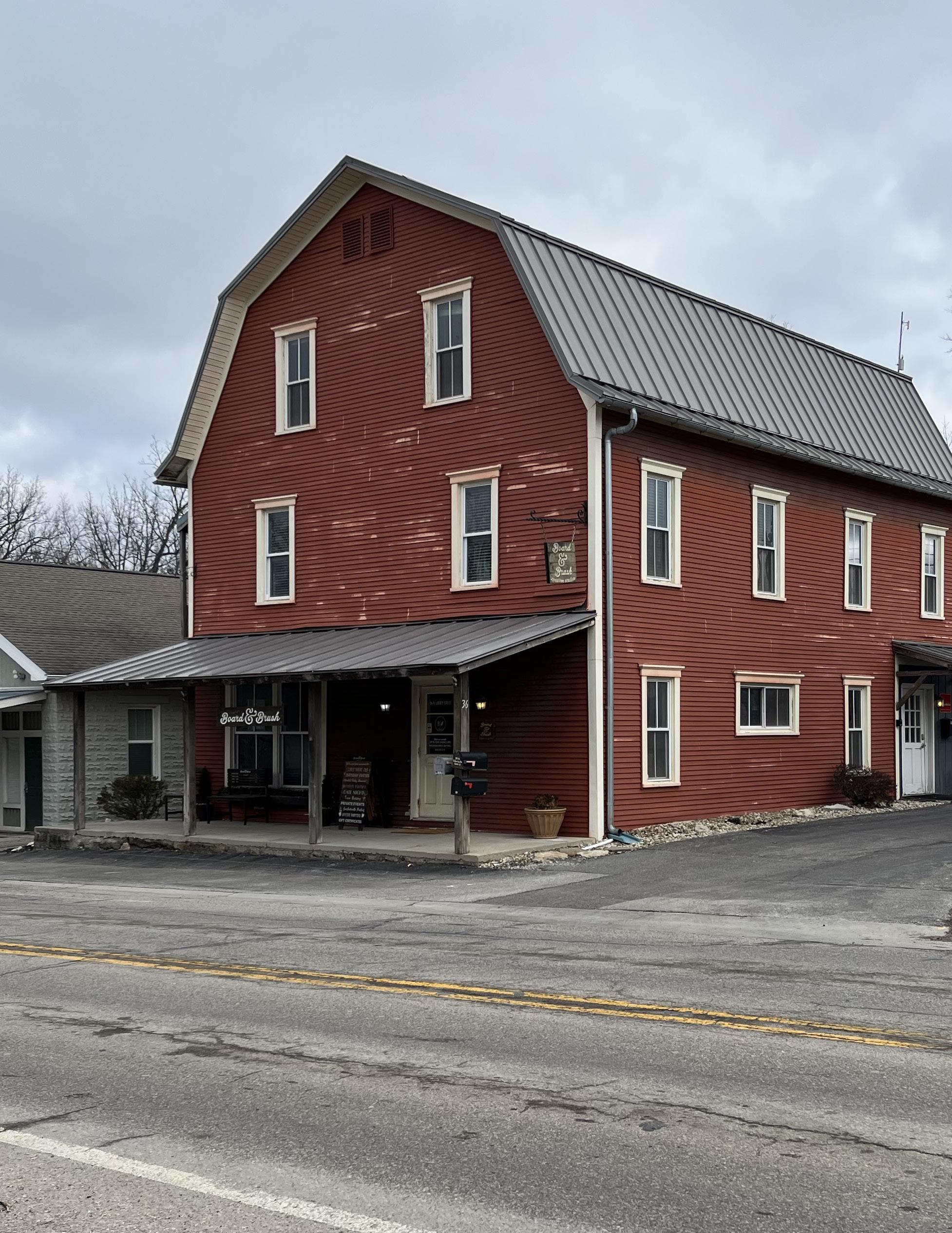
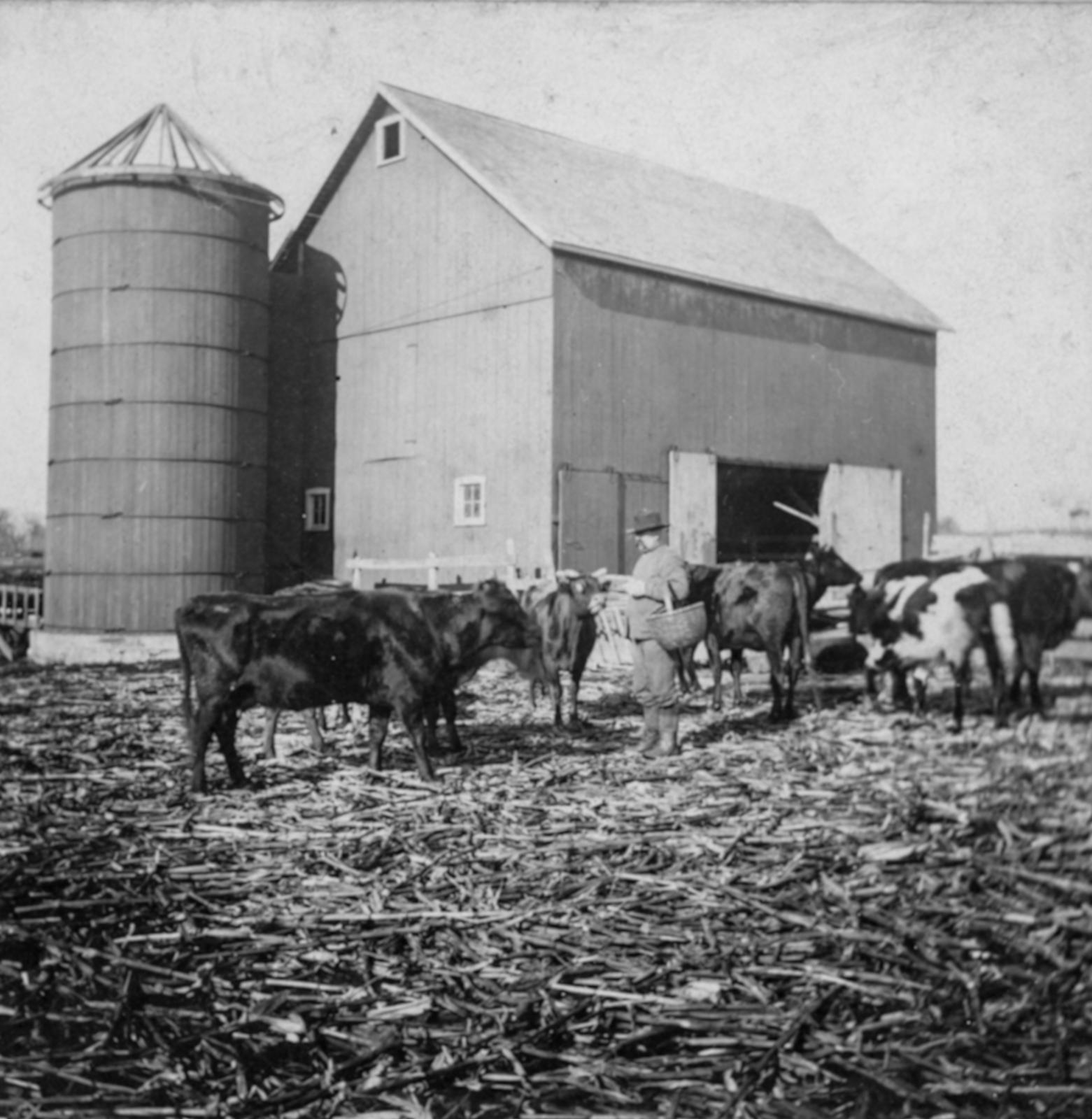
Farming was a way of life in the early days of Powell, and many of the settlers and their families engaged in farming to make a living. Families such as the Lowrys, Bennetts, Browns, and Askins would grow fruits, vegetables and grains, and raise livestock such cattle, sheep, and chickens for meat, eggs, and dairy. Grain would eventually be sent to the Powell Milling Company building at 36 North Liberty for further refinement.
The school system in Powell had many homes in its early years. Grades 1 through 8 were taught in the Powell School (77 South Liberty Street) from 1882 through 1911 and high school students would take classes in the first decade of the 1900s. The new Powell School opened on East Olentangy Street in 1911 and accept students in grade 1 through 12 until it closed in 1953 and was demolished in 1977.
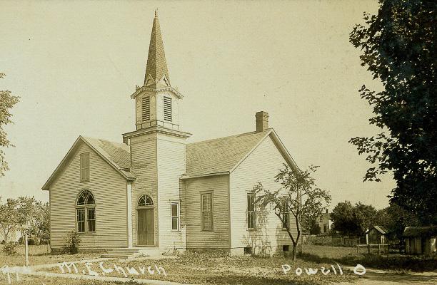
A Methodist Church and a Seventh Day Adventist Church are also located in the Historic Survey boundary. The Powell Methodist Church was built in 1859 on South Liberty Street. In 1902, the church was moved to its current location at 50 West Olentangy Street. It is no longer an active church, nor has it been for many years after the congregation moved to a new building elsewhere in the city, but the building has been home to many different businesses since. The congregation of the Seventh Day Adventist Church built a home for their church in Powell in 1906 at 55 East Olentangy Street. The church didn’t have a large congregation, and could not afford to keep their doors open, which led to the abandonment and eventual sale of the building. It is a retail shop today, though it had also previously been a single family home at one point.
The town remained small, with a population around 300 people for many years, only attracting visitors coming through town for either the Columbus Zoo or the Powell Speedway nearby. Because of the noise and the crowds, the town initiated the incorporation process, and Powell was incorporated as a municipality in 1947. This led to the election of the Mayor and City Council, as well as the establishment of the fire department. The small town charm remained in Powell until the 1980s, when major development began and Powell annexed nearby properties to expand its footprint. Powell became a proper city in 2000.
▶ THE LOWRY FARM. COURTESY OF THE POWELLLIBERTY HISTORICAL SOCIETY.
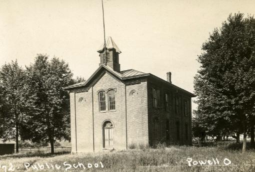
◀ THE OLD POWELL SCHOOL. COURTESY OF THE POWELLLIBERTY HISTORICAL SOCIETY.
▼ THE POWELL METHODIST CHURCH IN ITS CURRENT LOCATION. COURTESY OF THE POWELL-LIBERTY HISTORICAL SOCIETY.
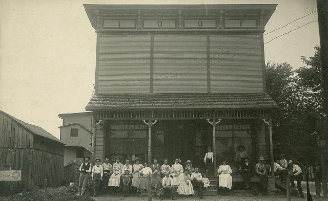
◀ THE INDEPENDENT ORDER OF ODD FELLOWS BUILDING AT 5 SOUTH LIBERTY STREET. THIS BUILDING HAD A FOOD MARKET ON THE FIRST FLOOR AND THE MEETING HALL ON THE SECOND. IT STILL STANDS TODAY AS A RESTAURANT. COURTESY OF THE POWELLLIBERTY HISTORICAL SOCIETY.
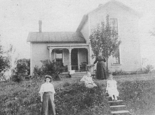
The Powell-Liberty Historical Society (PLHS), located in Powell at 103 East Olentangy Street, conducted a survey of their own to inventory buildings in Downtown between 2008-2011. This inventory utilized a form of their own design that documented the address, construction date, historic and current use, and other relevant historic context for 48 buildings along East and West Olentangy Streets and North and South Liberty Streets.
While a formal historic resource survey had yet to document the overall footprint of Historic Downtown Powell, 11 properties within the project area were surveyed using the Ohio Historic Inventory (OHI) form used by the Ohio State Historic Preservation Office (SHPO) in 2018. The reasoning behind these properties being surveyed was not indicated at the receival of the OHI forms, nor do the forms indicate a report that was written to accompany them. Those properties are:
• 15 North Liberty Street (DEL0112515)
• 5 South Liberty Street (DEL0112615), aka Kraft House 5
• 77 South Liberty Street (DEL0112715), aka the old Schoolhouse
• 120 South Liberty Street (DEL0112815)
• 80 East Olentangy Street (DEL0112915)
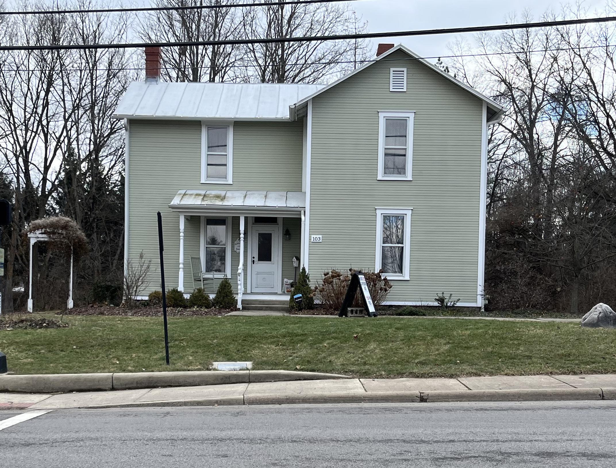
• 103 East Olentangy Street (DEL0113015), aka the Martin Perry House & the current home of the Powell Liberty Historical Society
• 38 West Olentangy Street (DEL0113115)
• 70 West Olentangy Street (DEL0113215)
• 71 West Olentangy Street (DEL0113315), aka Blackberry Patch Antiques
• 77 West Olentangy Street (DEL0113415), aka Lohcally Artisan Chocolates
• 87 West Olentangy Street (DEL0113515), aka Peachtree Street
While these buildings were previously surveyed, no register nominations at the local, state, or national level were ever completed, nor are there any other designated historic buildings in the City of Powell at any level.
TYPE OF PREVIOUS SURVEY
Surveyed with the Ohio State Historic Preservation Office’s OHI (Ohio Historic Inventory) Form
Surveyed with PowellLiberty Historical Society’s Custom Inventory Forms
Surveyed using both forms
Not surveyed before 2025

FIGURE 2: PREVIOUSLY RECORDED PROPERTIES MAP

SURVEYED PROPERTIES IN 2025
Surveyed
Not Surveyed
* These properties were not surveyed because they were built before 1975, not meeting the 50 year age minimum
Survey Area Boundary
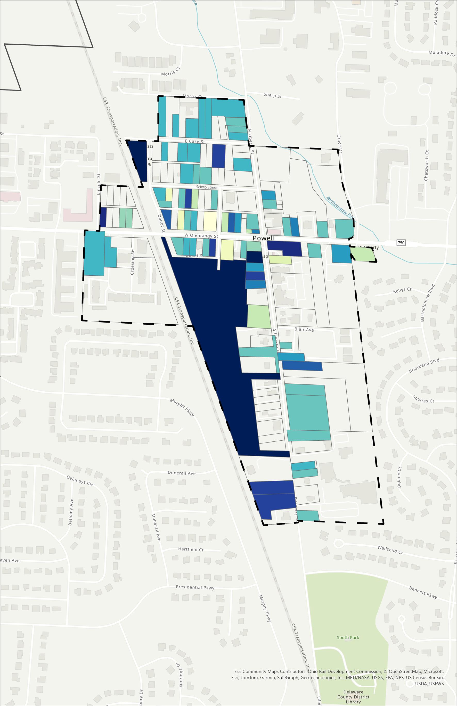
FIGURE 3: SURVEYED PROPERTIES WITH THEIR OHI NUMBERS
The survey of Historic Downtown Powell was completed according to the standards set by the Ohio State Historic Preservation Office through the project area. Within the survey boundary, there were 28 parcels that did not qualify for survey due to the buildings being under 50 years old. The majority of these buildings were located on South Liberty Street, but there was one on Case Street, one on Scioto Street, two on East Olentangy Street, four on West Olentangy Street, and four on North Liberty. One building initially identified as eligible was determined potentially ineligible and needing additional data confirmation during the research phase, therefore it was determined that the results of the documentation of 284 South Liberty Street would be omitted from the final result. In the end, 79 buildings in total were surveyed from the public right of way in January 2025. Ohio Historic Inventory (OHI) forms were completed for all qualifying properties.
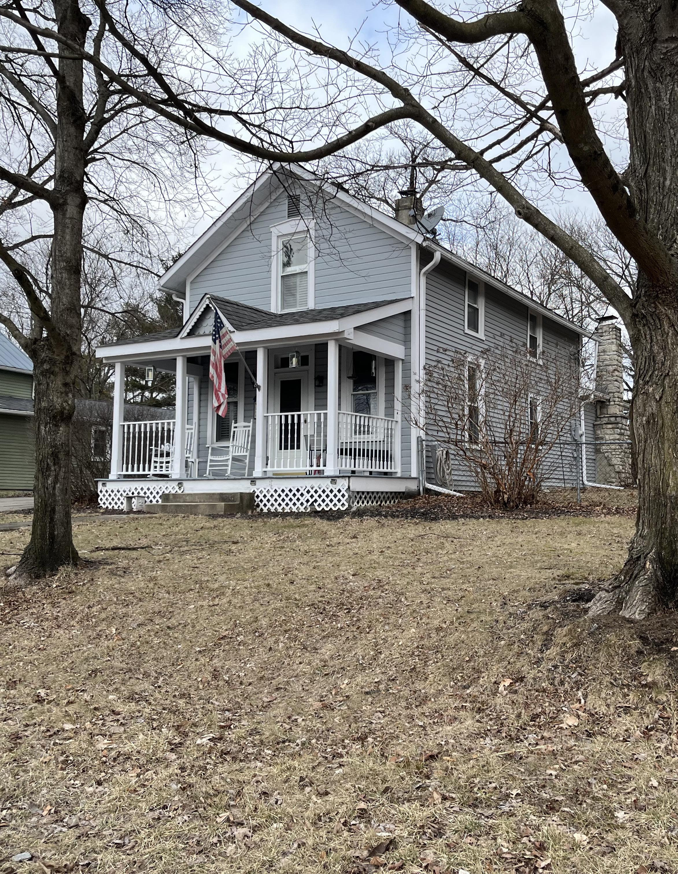
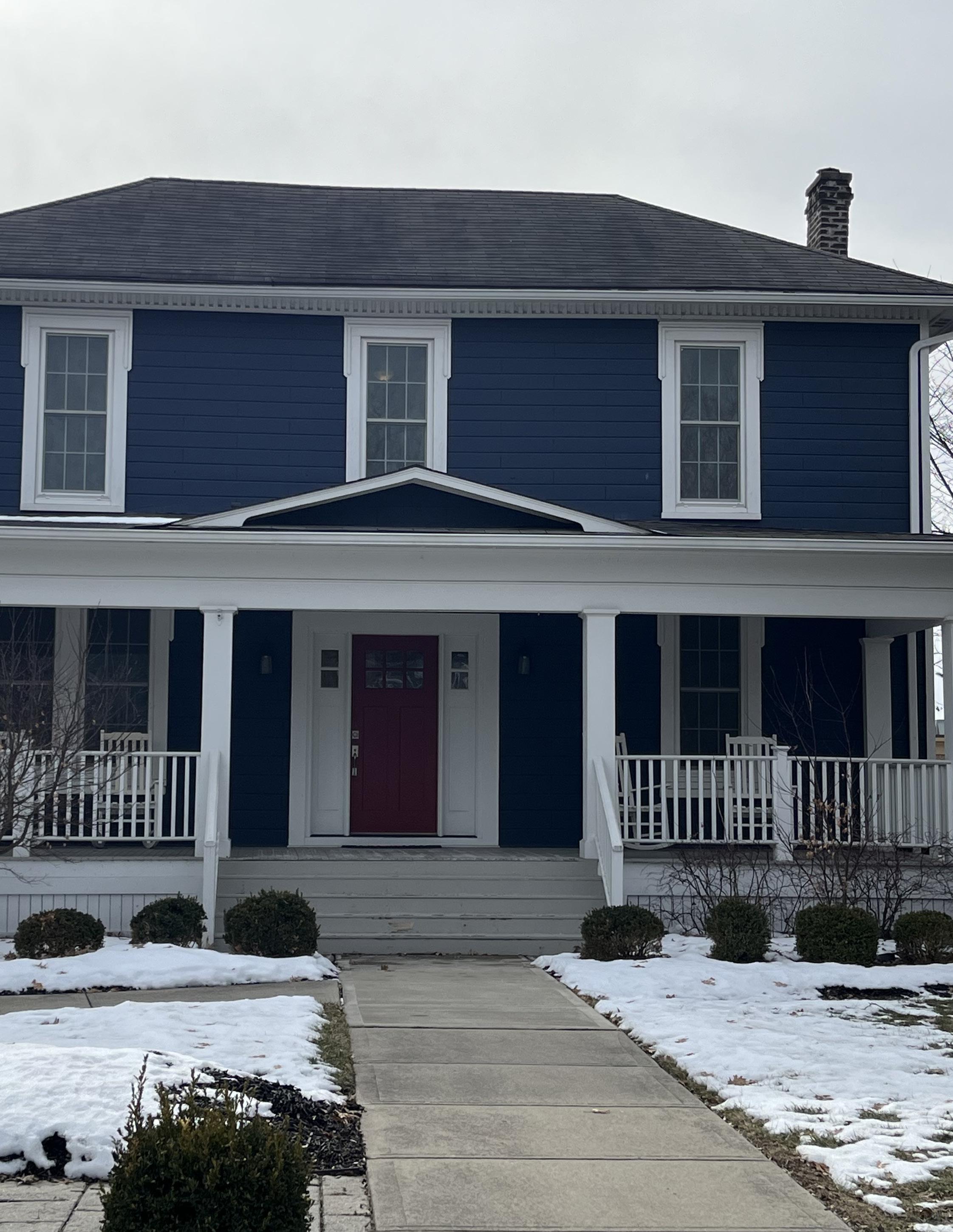
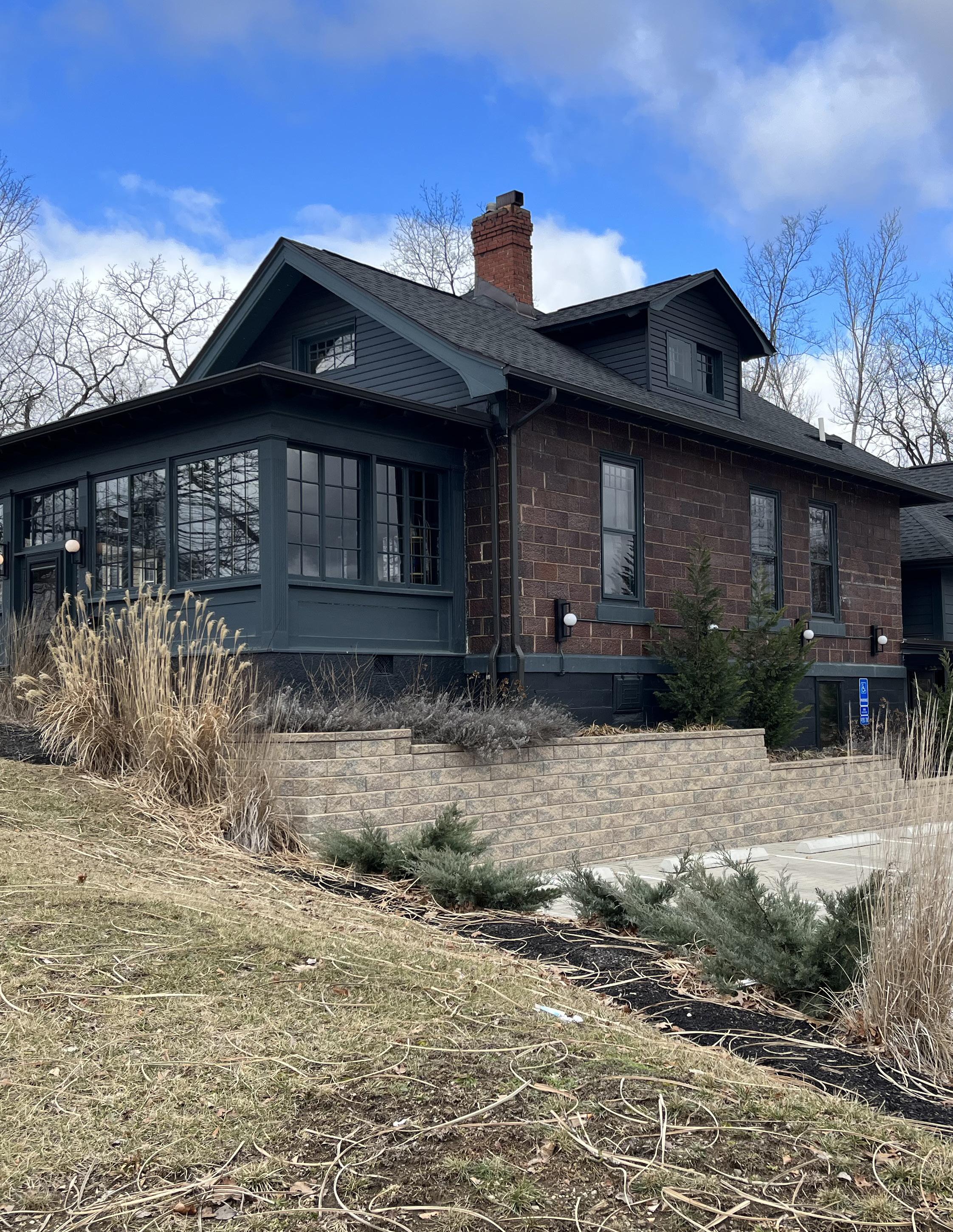
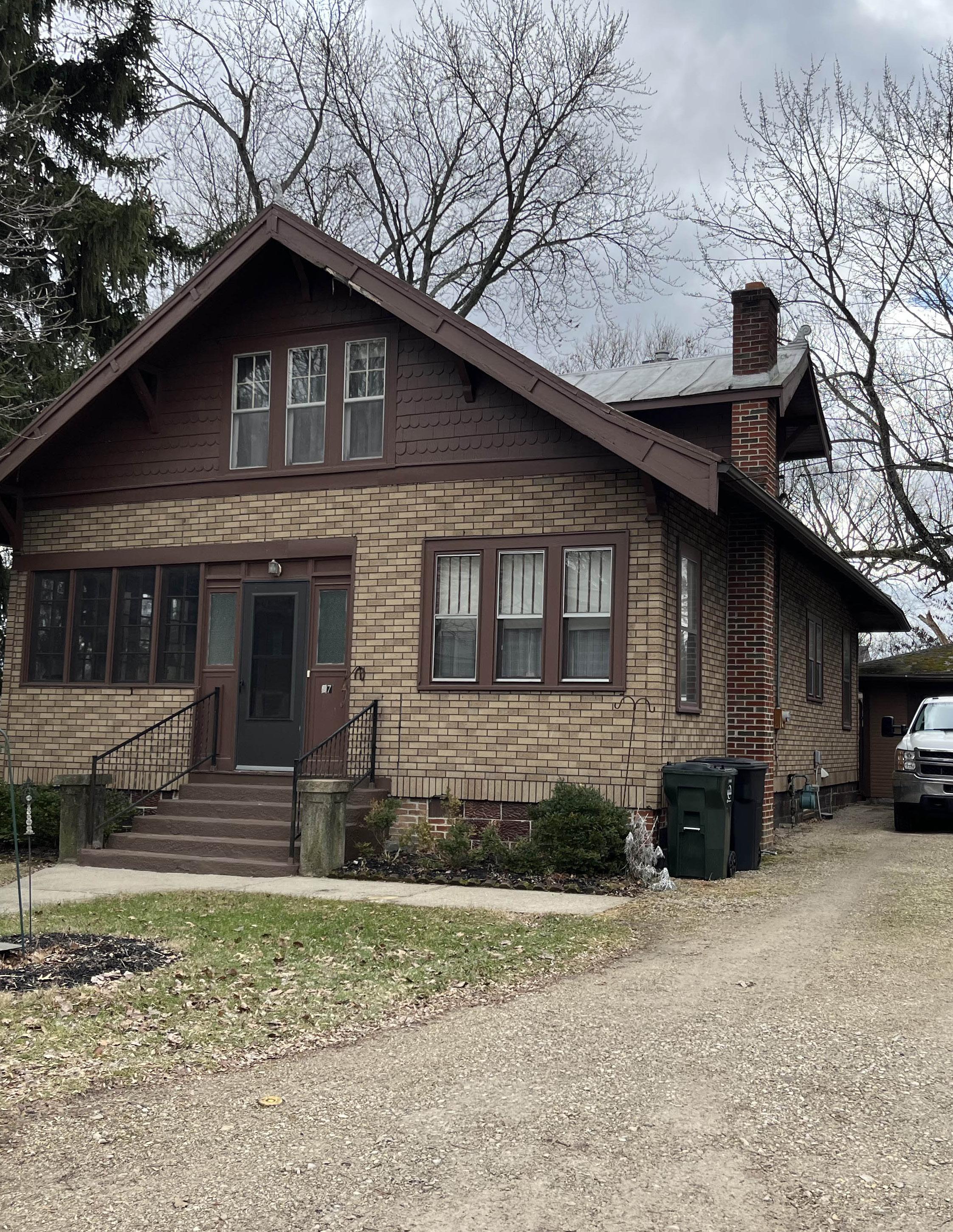
The buildings within the project area are exclusively one- and two-story buildings. Most of the buildings on North Liberty, South Liberty, West Olentangy, East Olentangy, and Hall Streets front concrete sidewalks parallel to their respective streets, while those on Depot Street, Scioto Street, and Case Avenue lack sidewalks at all and directly front their respective streets. All buildings are free standing and set back from the right of way.
The dates of construction for these buildings ranged from 1859 to 1973. As illustrated in the Table, “Number of Buildings Built by Decade,” 13 were built in the 1800s, 43 were built between 1900 and 1919, and 23 were built between 1920 and 1975. A map that illustrates the distribution of construction dates through the district can be found on the next page.
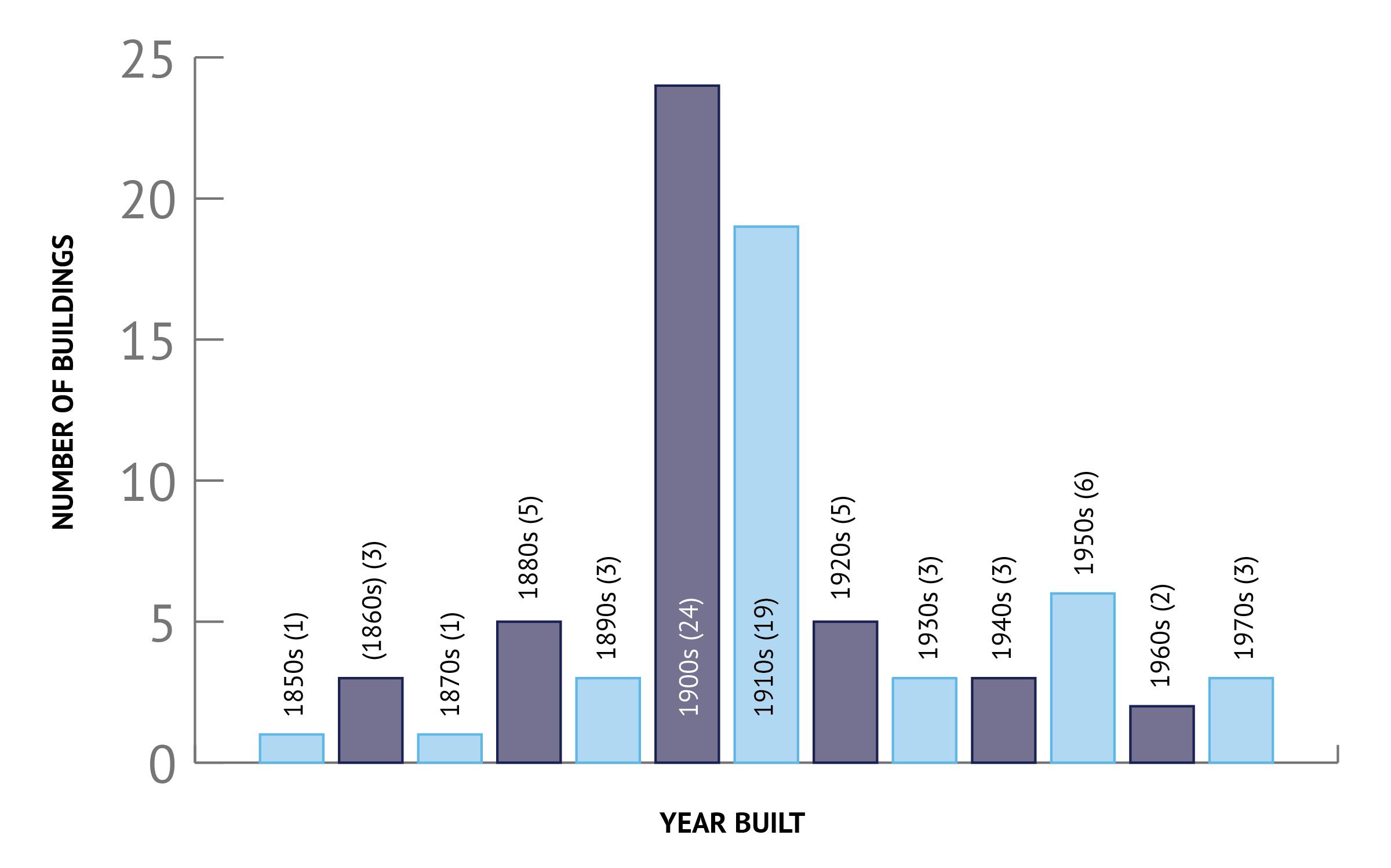
THE TOP THREE DECADES WITH THE MOST NUMBER OF BUILDINGS BUILT IN THE SURVEY AREA ARE 1900-1909 WITH 24 BUILDINGS, 1910-1919 WITH 19 BUILDINGS BUILT, AND 1950-1959 WITH SIX (6) BUILDINGS.
CONSTRUCTION DATE
1850 - 1859
1860 - 1869
1870 - 1879
1880 - 1889
1890 - 1899
1900 - 1909
1910 - 1919
1920 - 1929
1930 - 1939
1940 - 1949
1950 - 1959
1960 - 1969
1970 - 1975
FIGURE 4: SURVEYED PROPERTIES COLOR CODED BY DECADE BUILT
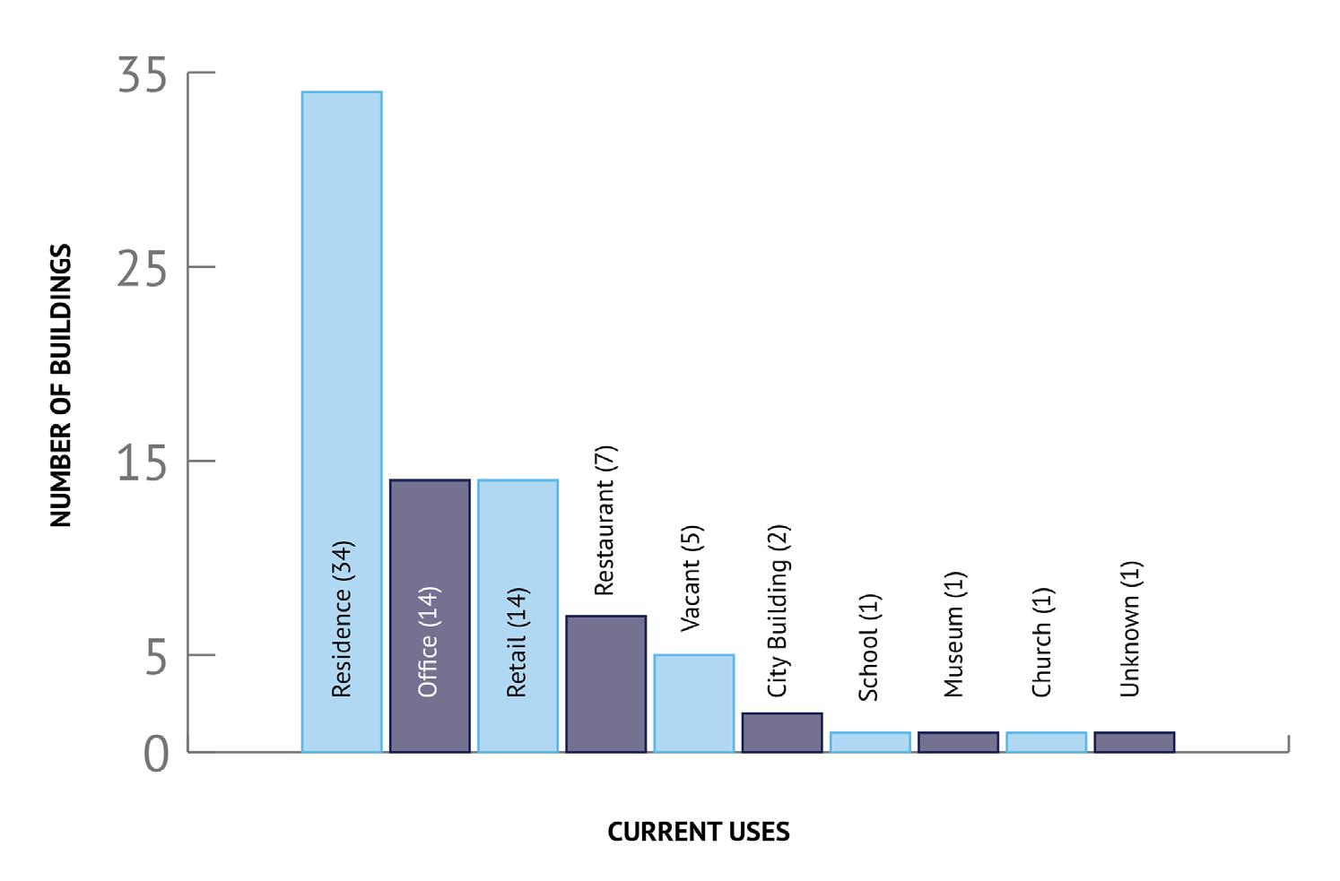
Historically, most of the buildings were single family dwellings with the commercial retail spaces located closer to the Liberty-Olentangy intersection. Over time, many of the single family residences along West Olentangy and East Olentangy Streets, and South Liberty Street up to the old Powell School building, had been converted into retail, restaurant, and office spaces. Today, the majority of the buildings within the survey area are still single family dwellings, but that number compared to the historic uses, has decreased, while the number of retail shops, restaurants, office buildings, and vacancies has increased, as illustrated between the tables titled “Number of Buildings by Historic Use” and “Number of Buildings by Current Use.” This can be caused by the continued development and outward expansion of the city limits of Powell, with more residential spaces being built away from the Historic District and modern amenities becoming easier to install in newer homes versus historic homes in the historic district.
▶ THE MOST COMMON USE OF EACH BUILDING HISTORICALLY, OR AT THE TIME IT WAS BUILT, WAS A SINGLE-FAMILY DWELLING.
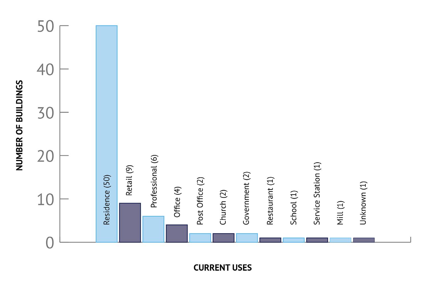
▶ THE MOST COMMON USE OF EACH BUILDING CURRENTLY STILL REMAINS A SINGLEFAMILY DWELLING, THOUGH ADAPTIVE REUSE HAS SEEN SOME OF THE HISTORICALLY SINGLE-FAMILY HOMES CONVERTED TO RETAIL AND OFFICE SPACES.
The architecture styles within the survey area are mostly vernacular in nature, with a few examples of high style architecture. Due to the more rural nature of the area at the time of development, buildings being folk or vernacular in nature is to be expected. Though the styles are mostly vernacular in nature, there are elements present throughout the survey area of Queen Anne, Colonial Revival, Italianate, Craftsman, Shingle, and modern architecture styles. There are a handful of high style architecture in the survey area, providing examples of Eastlake, Colonial Revival, Italianate, Greek Revival, Queen Anne, Craftsman, Georgian Revival, and Second Empire architecture. Vernacular architecture is the design and construction of buildings in a traditional technique, using locally available materials, to meet the needs of the region. High style architecture displays the prominent characteristics of well-known, specific architecture styles, utilizing the elaborate ornamentation and styling techniques at a much larger, more notable scale.
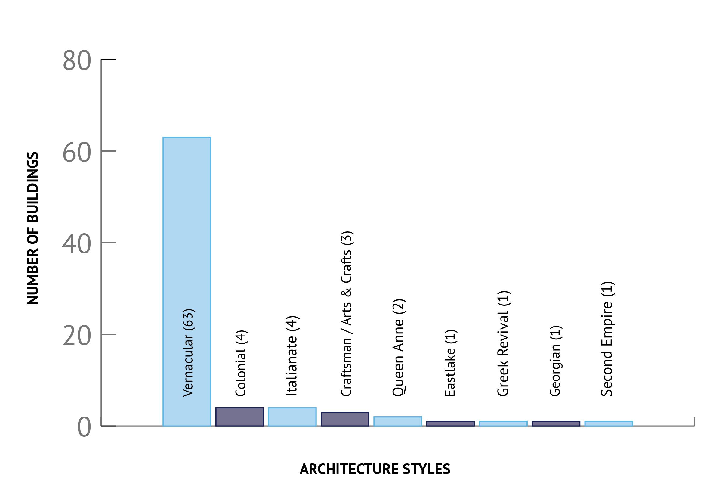
THE MOST COMMON ARCHITECTURE STYLE IS VERNACULAR WITH FEATURES AND CHARACTERISTICS OF QUEEN ANNE, COLONIAL REVIVAL, ITALIANATE, CRAFTSMAN, SHINGLE, AND OTHER HIGH STYLES. THERE ARE A SMALL HANDFUL OF BUILDINGS IN THE SURVEY AREA THAT ARE GOOD EXAMPLES OF HIGH STYLE ARCHITECTURE.
When surveying a historic building, another important aspect of the survey is determining a building’s historic significance and whether or not the building retains any kind of historic integrity. Significance and integrity often go hand-in-hand, as a building hoping to qualify for the National Register of Historic Places must have historic significance that falls under one or more criteria category, AND retain historic integrity to convey that significance.
A building must be determined to be significant under one or more of the four National Register Criteria, defined by the National Park Service, to be eligible for inclusion on the National Register of Historic Places. The Criteria categories are:
• Criteria A: A property must be associated with one or more events important in the defined historic context.
• Criteria B: A property must be associated with a person significant to America’s past.
• Criteria C: A property must display distinctive characteristics in its architecture or construction, be that related to artistic value or being the work of a master.
• Criteria D: A property must have information that contributes to the understanding of human history or pre-history.
There are other criteria that could be applicable in Powell, such as moved buildings, religious properties, cemeteries, and reconstructed properties.
Integrity, as defined by the National Park Service, is the ability of a property to convey its significance. There are seven aspects used to evaluate if a property has retained its historic integrity. A property that retains its integrity will possess several of the aspects, though it is sometimes a subjective judgement.
• Location: the place where the historic property is located was constructed or where the historic event occurred.
• Design: the combination of elements that create the form, plan, space, structure, and style of the property.
• Setting: the physical environment of a historic property.
• Materials: the physical elements that were combined or deposited during a particular period of time and in a particular pattern or configuration to form a historic property.
• Workmanship: the physical evidence of the crafts of a particular culture or people during any given period in history or pre-history.
• Feeling: a property’s expression of the aesthetic or historic sense of a particular period of time.
• Association: the direct link between an important historic event or person and historic property.
The following recommendation is not a formal determination of eligibility; rather, it is the informed, expert opinion of the Designing Local team. Based on the results of the survey and historical research, a new historic district that highlights the period of settlement and growth in Powell can be established with boundaries as shown in Figures 6 & 7. This new historic district would be eligible for listing as a historic district under Criteria A: the association with one or more events that are deemed important in historic context. Within this boundary, the properties best exemplify this time of Powell’s establishment and development between 1859 and 1940. The buildings within this district are both residential and commercial. It was within many of these buildings that the first settlers of Powell resided in and where they conducted day-to-day business and life. Many of the properties meet the threshold for eligibility as contributing within a National Register historic district in part to the minimum age requirement of 50 years, their historic context in relation to the settlement of the City, and their maintained integrity of the buildings through a variety of applicable aspects of integrity. These buildings, while some of which have been updated with modern materials, retain the feeling and design of their original construction and appearance on the street scape.
There are properties within this proposed district that were built outside the proposed period of significance. Those buildings would be considered non-contributing, but would still be held to some standard for being within the district under local ordinances and procedures, such as applying for a certificate of appropriateness and going through the design review process.
Proposed District Boundary
Survey Area Boundary
CONSTRUCTION DATE
1850 - 1859
1860 - 1869
1870 - 1879
1880 - 1889
1890 - 1899
1900 - 1909
1910 - 1919
1920 - 1929
1930 - 1939
1940 - 1949
1950 - 1959
1960 - 1969
1970 - 1975
Proposed District Boundary
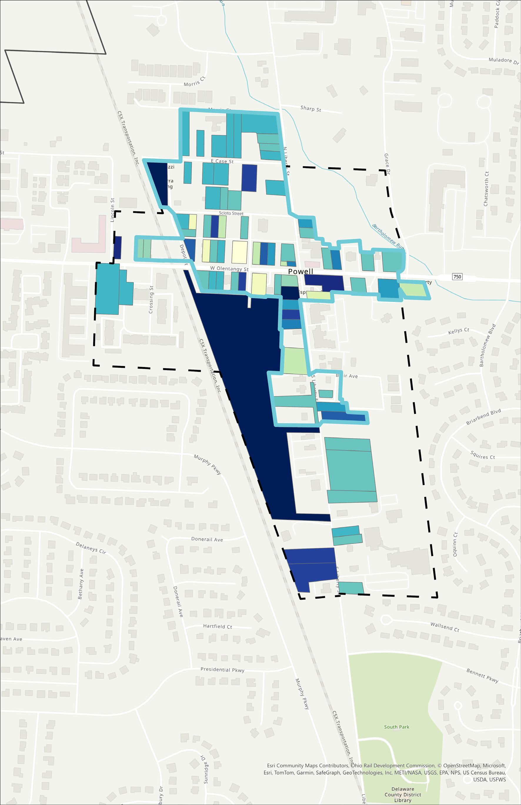
FIGURE 6: PROPOSED HISTORIC DISTRICT BOUNDARY WITH PARCELS CODED BY DECADE BUILT.

The following chapter presents the recommendations of a potential historic district, its period of significance, its boundaries, and the steps it would take for the City to create this district. Other recommendations within this chapter are short - and long-term goals for City Staff to consider as they continue to further consider their historic preservation goals and any future initiatives.
The City of Powell is already moving forward in the right direction when it comes to the preservation of the historic downtown. The Powell Code of Ordinances calls out the Downtown District Overlay, whose boundaries influenced the survey area boundary. This Downtown District also has a design review process that is overseen by the Historic Downtown Advisory Commission. It is recommended that writing a local historic preservation ordinance, creating a new local historic district and historic district zoning overlay, and establishing a city-managed local historic register are short-term, attainable goals for the City.
Short-Term Goal #1: Updating the Powell Zoning Code to Include the Local Historic District and Historic District Zoning Overlay
A Local Historic District is a group of historic buildings and/or sites deemed significant to the City’s cultural fabric, that is then designated by the local legislature in the form of a local historic preservation ordinance, and is subject to review under a local historic preservation design review commission. By designating a local historic district and a matching historic district zoning overlay, the City can elaborate on the history and significance of the area, specify boundaries, define historic terminology, and establish district specific processes such as obtaining certificates of appropriateness and what work would be granted an approval, and the district specific design review board.
Creating a local historic district may come with some push back from its residents as there may be a perception of more regulations and additional review processes to begin renovation and restoration projects, however there are benefits. These include:
1. Local districts protect the investments of owners and residents of historic properties.
2. Properties within local historic districts appreciate at rates greater than the local market overall as well as faster than similar, non-designated neighborhoods.
3. Local districts encourage better quality design.
4. Local districts help the environment through retaining and reusing existing resources.
5. Local districts are energy-efficient.
6. Historic districts are a vehicle for education.
7. Historic districts can positively impact the local economy through tourism.
8. Protecting local historic districts can enhance business recruitment potential.
9. Local districts provide social and psychological benefits.
10. Local districts give communities a voice in their future.
Prior to establishing a local historic district, it is imperative that the public be involved and educated on the initiative. Residents and city leaders need to know why this district is being formed, on what grounds, what is the history, and what designation means to them. They also need to support the project, so social media outreach, media engagement, and education materials should be made available to anyone interested. Working with the Powell-Liberty Historical Society to advance this process would be beneficial, especially in order to coordinate support activities, provide staff assistance, and help educate the community on the history of the new district. The history and research on the historic resources has been completed with the OHI forms through the survey, and the suggested boundary lines have been drawn. The boundary lines can be adjusted if needed when the final district is being created. And finally, once the historic district has been established, continuous education and reiterating the importance of the history will keep the community engaged, aware, and appreciative of the district. It is also important that any new residents learn about the historic district through real estate agents, mailing notices, or even through groups such as neighborhood associations.
A Zoning Overlay is a specified zoning district that is placed overtop existing zoning boundaries. Zoning Overlays, especially historic district zoning overlays, are a planning tool that allows buildings within that overlay to be required to meet certain guidelines and regulations set forth by the City and associated Historic District Commissions. A new Historic Powell Zoning Overlay would reflect the boundaries of the new Local Historic District and would require property owners within the district boundaries to follow any Historic District Design Guidelines and any procedural protocols specific to design review in that District Overlay set forth by the Zoning Code.
The City of Powell does already have an entity that reviews environmental changes in the Historic Downtown, the Historic Downtown Advisory Commission (HDAC), established through the Downtown District Overlay in the City of Powell Zoning Code. The City of Powell and HDAC can determine whether HDAC is to oversee any changes to both the Downtown District Overlay and the new Local Historic District, or if it would be better to restructure HDAC to be the overseers of the new Historic District and the City reviews the remainder of the Downtown District.
Updating the text to establish the new local historic district with the accompanying overlay is recommended to support a new, or revamped, historic district, design review board, and procedures for design review.
For more information on the benefits of creating a local historic district, click HERE.
A third short-term goal discussed with the City of Powell would be the establishment of a Local Historic Register, recognizing historic buildings and sites within the City of Powell. The Local Historic Preservation Ordinance would determine the governing body of this register as well as the designation requirements and the application process. Designation on the register could also include benefits for properties, such as advice or ideas for renovation projects or even financial incentives such as grants, loans, or refunds. Properties on the register could also be required to meet certain obligations such as working with a historic preservation commission when altering, moving, or demolishing a structure, major alteration work, or routine maintenance and landscaping projects. Since it would be a local register, the requirements and expectations are determined by the City.
The Certified Local Government (CLG) Program is run with cooperation between the state and local governments and Federal partners to promote historic preservation across the country. By becoming a CLG, the local government and community make a commitment to historic preservation in their city and commit to adhere to national standards of practice in order to preserve, protect, and advocate for cultural heritage across the country. To become a CLG, a city must have:
• A qualified commission of 5+ members who designate historic properties and review proposed changes to the historic environment.
• An ordinance designed to protect historic resources and offer guidance to those wishing to make changes to historic buildings, sites, and districts.
• A procedure for identifying historic properties by which they can be surveyed and recorded, designated locally, and nominated to the National Register of Historic Places.
• A public participation program that invites and encourages citizens to participate in the community’s historic preservation.
No matter the size of the community, any local government can become a CLG, whether it’s a small village or a major urban center. Once approved, a CLG has the opportunity to compete for CLG grants. More on the CLG grants can be found below under Funding Opportunities.
For more information on Certified Local Governments, click HERE and HERE.
In an effort to continue planning for future preservation work, the City should revisit the survey in 10-15 years. By revisiting the survey, new buildings within the survey area may be eligible for documentation and evaluation by reaching that 50 year-old milestone. Narratives and research can always be updated, and future architectural historians may wish to expand the period of significance as recommended in this report. Revisiting the survey and adjusting the historic district boundary may benefit the City’s future preservation endeavors. Adjusting the historic district boundary will affect any Zoning Overlays and any new residents who need to follow a historic preservation ordinance and historic design review processes, but that is something to consider as the situation arises.
Contributing Properties
Non-Contributing Properties
Proposed District Boundary
Survey Area Boundary
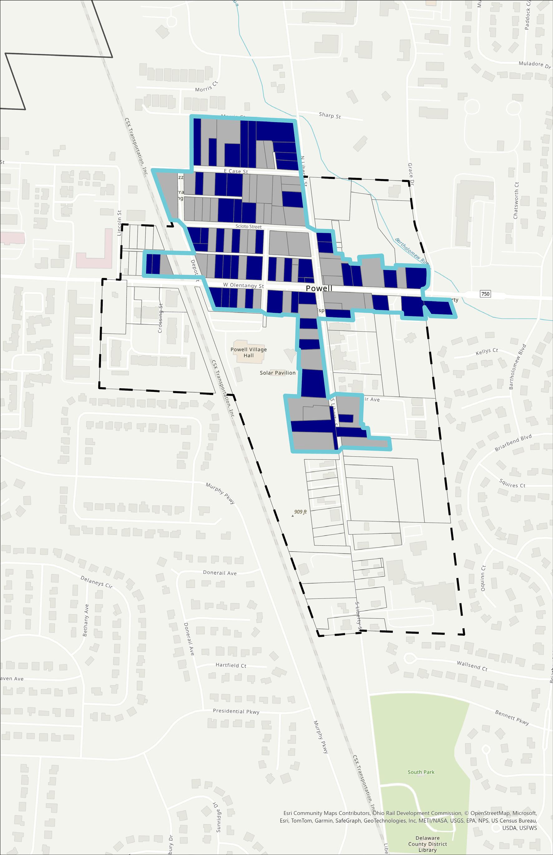
FIGURE 7: CONTRIBUTING AND NON-CONTRIBUTING PROPERTIES WITHIN THE PROPOSED HISTORIC DISTRICT BOUNDARY.
There are two Historic Tax Credit programs that property owners in Ohio can apply to to earn funds for appropriate rehabilitation work: the Federal Historic Preservation Tax Credit and the Ohio Historic Preservation Tax Credit.
Properties applying for the Federal Historic Tax Credit Program must be 50 years or older, and must be eligible for individual listing or contribute to a historic district on the National Register of Historic Preservation. If a property meets the criteria for evaluation, is the right age, and retains enough historic integrity and significance, the owner is eligible to receive a 20% income tax credit after the rehabilitation project is completed. Applications are reviewed by staff members of the National Park Service and the State Historic Preservation Office.
Properties applying for the Ohio Historic Preservation Tax Credit must be 50 years or older, individually listed or contribute to a historic district on the National Register of Historic Places, be a National Park Service Certified Historic District or Certified Local Government historic district, or be listed as a local landmark by a Certified Local Government. Properties must also be income-producing, so single-family or multi-family residences are not eligible to apply. Properties that do meet the criteria of eligibility could earn a credit of up to 25% of qualified rehabilitation expenditures accumulated during a project.
For more information on the Federal Historic Tax Credit Program, click HERE.
For more information on the Ohio Historic Preservation Tax Credit Program, click HERE.
Certified Local Government (CLG) Grants are only available to qualified CLGs. These funds come from the U.S. Department of the Interior’s Historic Preservation Fund (HPF), which is administered by the National Park Service. 10% of the HPF set aside for Ohio is meant for CLG Grants, and grants are awarded on a 60% / 40% matching basis. Projects categorized as Funding Priorities, which are outlined each year in the State Historic Preservation Plan, can receive funds that cover up to 100% of the project cost.
For more information on Certified Local Government Grants, click HERE.
The Ohio History Fund is a competitive matching grant program managed by the Ohio State Historic Preservation Office (SPHO). Non-profit organizations registered in Ohio and public entities, such as historical societies, museums, libraries, historic preservation groups, local government entities, and more are eligible to apply. There are three (3) categories of projects supported by these grants: Organizational, Programs & Collections, and Brick & Mortar.
Organizational grants are awarded for projects that see historical societies and similar organizations improve their internal abilities to better serve themselves and their communities. This could include providing training for board and staff members, developing volunteer or membership programs, creating assessment or strategic plans, and more. The grant funds for these projects can range between $1,000$4,000 and projects must be completed within a year.
Programs & Collections grants are awarded for projects that support the continued documentation and collection of historic resources. These projects include updating public programming, designing historic resource exhibits at a local museum, digitizing collections, nominating sites to the National Register of Historic Places, creating walking tours and events, and more. The grant funds for these projects can range between $2,000 - $20,000 and projects must be completed within two years.
Brick & Mortar grants are awarded for projects that improve the built environment. These projects include restoration, rehabilitation, protection, or acquisition of sites and buildings on the National Register of Historic Places, or projects involving buildings that contain archival collections. The grant funds for these projects can range between $2,000 - $20,000 and projects must be completed within two years.
For more information on the Ohio History Fund, click HERE

Additional Resources
Ohio State Historic Preservation Office
800 E 17th Avenue
Columbus, Ohio 43211
https://www�ohiohistory�org/preserving-ohio/
National Park Service, U.S. Department of the Interior
Preservation Publications
Preservation Briefs
Other Useful Links
Local Historic Preservation Ordinance
Becoming a Certified Local Government
Ohio Historic Preservation Tax Credit Program
Alteration: the aesthetic, architectural, mechanical, or structural change to the exterior of any significant part of a building.
Building: any structure used to shelter human activity.
Certificate of Appropriateness: a document that certifies proposed work on a historic property is appropriate for the building and the historic district, and that the work does not negatively impact the character or history of the building or historic district. A certificate of appropriateness is attained by appearing before a design review board or historic district committee prior to obtaining building permits.
Certified Local Government (CLG): a Certified Local Government is a municipality that has joined a program that ensures commitment to advancing historic preservation initiatives set forth by the State Historic Preservation Office and the National Park Service. Certified governments are then eligible for competitive grants to complete historic preservation projects.
Contributing Property: a property within a historic district that retains historic significance and integrity and contributes to the period of significance and history of the district.
Demolition: the act or process of destroying or removing a portion or the entirety of a building or structure.
Designated Property: a property that has been identified as a landmark, historic property, or contributing property in a historic district.
Distinctive Character: distinguishing architectural and aesthetic features that are indicative of a historic district or high style of architecture.
Historic District: an area with a group of buildings designated as being historically significant and retaining integrity to a certain period of significance.
Historic Eligibility: when a building or site retains enough historical significance and retains enough integrity to be designated or nominated to a historic registry, such as the National Register of Historic Places or a local historic register.
Historic Preservation Commission: a group appointed by City Council to identify, approve, and designate historic structures and sites. A Historic Preservation Commission is usually also in charge of reviewing properties that require a Certificate of Appropriateness for rehabilitation, renovation, and larger scale maintenance projects on properties within a historic district.
Historic Property: a property, structure, site, building, landscape, or district identified as historically significant with sufficient integrity.
Integrity: The ability of a property to convey its historic significance through the seven aspects of integrity. The seven aspects of integrity are location, design, setting, materials, workmanship, feeling, and association.
National Register of Historic Places: the country’s official list of pre-historic and historic properties, buildings, structures, sites, landscapes, and districts worthy of preservation. The National Register of Historic Places (NRHP) was established by the Historic Sites Act of 1935 and was later expanded upon by the National Historic Preservation Act in 1966. Buildings on the the NRHP need to meet the criteria of evaluation by retaining enough historic integrity to convey its historic significance and by encompassing significance in at least one of four categories:
• Criteria A: A property must be associated with one or more events important in the defined historic context.
• Criteria B: A property must be associated with a person significant to America’s past.
• Criteria C: A property must display distinctive characteristics in its architecture or construction, be that related to artistic value or being the work of a master.
• Criteria D: A property must have information that contributes to the understanding of human history or pre-history.
Non-Contributing: an individual property within a historic district that does not share the distinctive characteristics of the neighborhood and/or was built outside the period of significance.
Non-Income Producing: a property, such as a single-family dwelling or institutional property, that does not generate income in the form of rent, profit through retail or food and beverage services, or any other way that the owner of the building benefits financially.
Secretary of the Interior’s Standards for the Treatment of Historic Properties: standards developed, adopted, and amended by the Secretary of the Interior of the United States that act as a guideline of best practices for the preservation, rehabilitation, restoration, and reconstruction of historic buildings.
Significance: having historic, architectural, or aesthetic qualities deemed important to a culture or region that leads to designation on historic registers.
ADDRESS
DEPOT STREET
30 DEPOT ST DEL0129615 1900 HOUSE
41 DEPOT ST DEL0129715 1970 RESTAURANT
HALL STREET
47 HALL ST DEL0129915 1972 CITY OFFICE
STATE ROUTE 750 W
2409 STATE ROUTE 750 W DEL0129815 1901 FARM