Catalogue edited by Arnie Anonuevo, Daniel Crouch, Iona Fielding, Rose Grossel, Kate Hunter, Ellida Minelli, Massimo De Martini, Mia Rocquemore, Nick Trimming and Julian Wilson
Design by Ivone Chao and Nicky Valsamakis
Photography by Louie Fasciolo and Marco Maschiao
Terms and conditions: The condition of all books has been described. Each item may be assumed to be in good condition, unless otherwise stated. Dimensions are given height by width. All prices are net and do not include postage and packing. Invoices will be rendered in £ sterling. The title of goods does not pass to the purchaser until the invoice is paid in full.
Altea Gallery Limited 35 Saint George Street London W1S 2FN
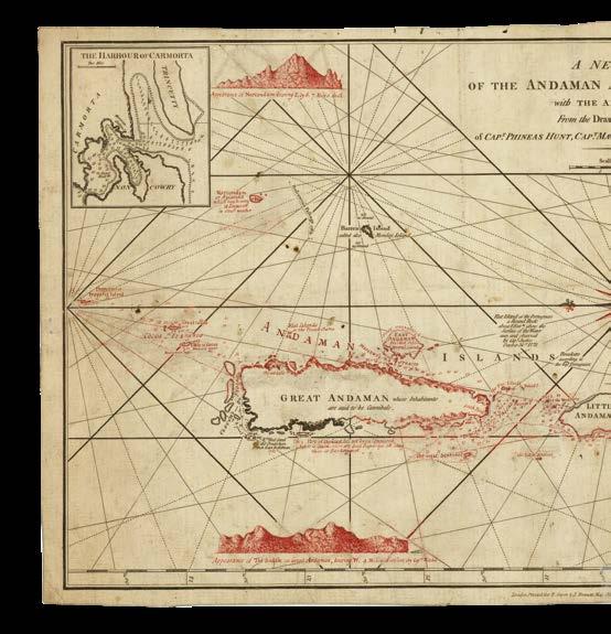
Kavalam chundan (a type of snake boat) is here victorious!
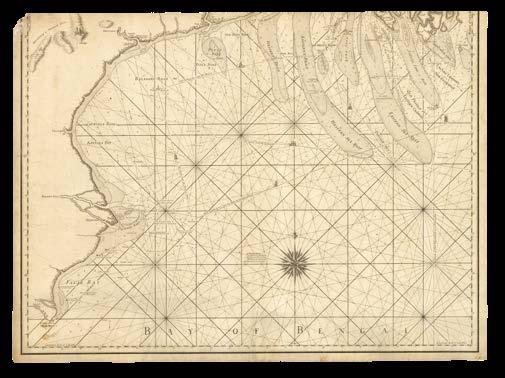
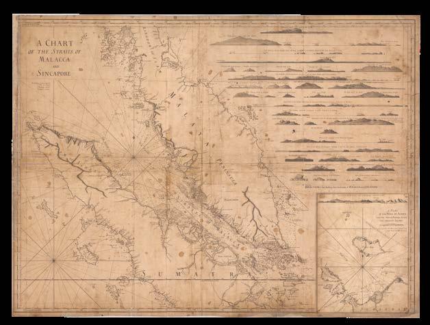
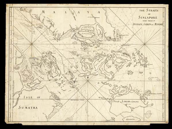
Indian Ocean
In the late-sixteenth century, the Portuguese and Spanish domination of the eastern and western hemispheres, respectively, began to face challenges from the English and the Dutch. In 1600, Queen Elizabeth I granted a charter to a private syndicate, the English East India Company (EIC) that henceforth allowed it a monopoly on all English trade with the East Indies. After gaining its initial foothold in India in 1612, and rapidly expanding its influence across the subcontinent, the EIC opened up a massive new market the following century, when China’s Kangxi Emperor granted the Company rights to trade for tea and silver at Canton (Guangzhou). By 1720, the EIC’s activities accounted for fifteen percent of Britain’s total imports. It was not long before the Company had established factories in Banten (Java), Ayuthaya, and Patani, and was conducting limited trade with Cambodia and Cochin-China. Likewise, at the dawn of the seventeenth century, the VOC had been awarded a monopoly of Dutch navigation in the vast area between the Cape of Good Hope and the Straits of Magellan (the long way round!) and the Company soon established its own trading empire that extended from Southern Africa to Southeast Asia. Thus, while the EIC was preeminent in mainland India, the Dutch dominated Indonesia and the Malay Peninsula, although both parties remained very much interested in the other’s possessions.
This is evident on both English and Dutch sea charts of the Indian Ocean which, in addition to showing the most up-to-date navigational information and routes to the east, take a special interest in the strongholds and notable voyages of their rivals. The sea charts themselves were closelyguarded, but smuggling was not uncommon as each sought to obtain the valuable knowledge to be found on the charts of the other. At times of lesser tension, however, information was sometimes shared, and chart-makers were not hesitant to include hydrographical information from their rivals’ published charts. The charts presented here illustrate this story of European rivalry over the waters of the Indian Ocean during the seventeenth and eighteenth centuries.
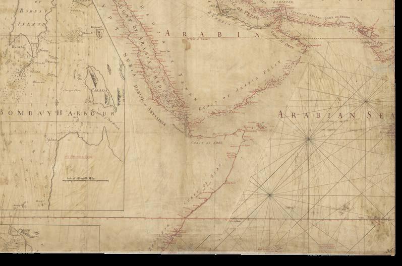
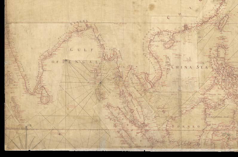
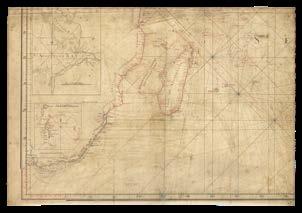
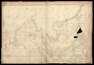
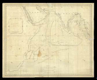
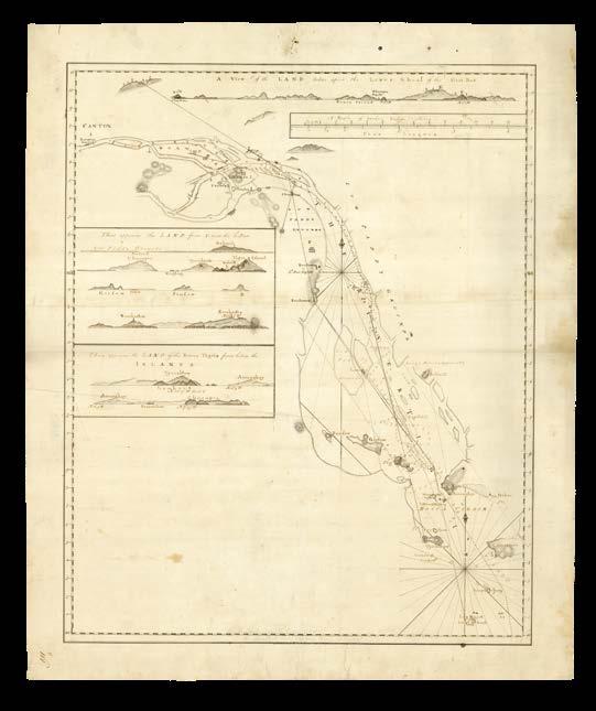
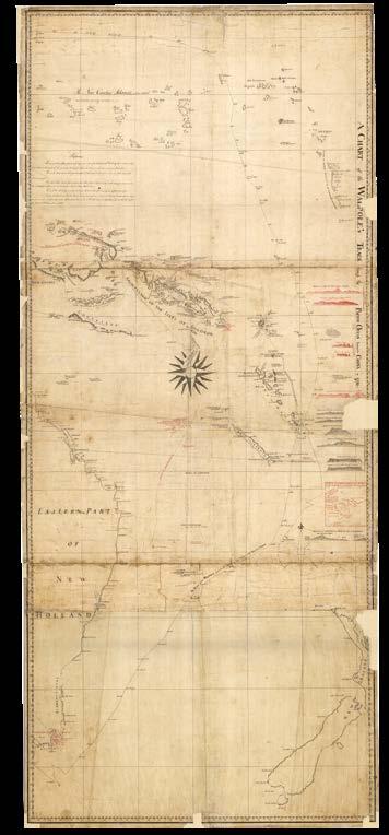
[SAYER, Robert]
[A New and Correct Chart of the Indian Ocean from the Cape of Good Hope to Canton; Including The Arabian and Persian Gulfs, The China Sea, The Oriental Islands, and the Western Part of New Holland: with all the Isles, Shoals and Dangers newly discover’d in these Seas... To my worthy friend Joseph Huddart, Esqr, Commander of the Royal Admiral, East Indiaman, to whose practical knowledge and accurate observations in these seas, and on their several coasts, as well as to his liberal communication of them, the public is greatly indebted for considerable improvements in navigation, this chart is respectfully inscribed by his affectionate humble servant Robert Sayer].
Publication [London, Robert Sayer, 53 Fleet Street, 1st. Jan.y 1787, but earlier].
Description
Large office working manuscript chart on four sheets, pen and black and red ink on paper, with numerous inset corrections and paste-overs.
Dimensions
Each sheet 505 by 725mm (20 by 28.5 inches).
The progress of a chart - publisher’s preliminary working manuscript
With these four sheets, Robert Sayer’s monumental chart of the Indian Ocean takes on its first form. It was one of the most ambitious charts produced by Robert Sayer, after he separated from his business partner John Bennett in 1785. Together, from 1778 they had published an ‘Oriental Neptune’, and later an ‘East India Pilot’, updating and producing new charts of the entire region over several years, but nothing quite on the scale of this chart.
In this working manuscript, designed to establish the general scale and shape of the new chart, the mapmakers have patched whole continents together as insets to surround the central Indian Ocean. A large vignette map of “Bombay Harbour” appears in Northern Africa, which in the printed map was replaced with the title and dedicatory cartouche, and a smaller inset of the “Bay of Johanna”. While there are rhumb lines, and placenames, there are no sailing directions.
The completed chart would be unveiled to the public on January 1st, 1787. It was then extended, later that same year, with an additional sheet to show the Eastern Coast of Australia (see item 203).
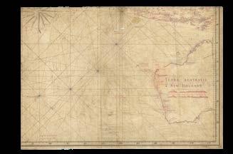
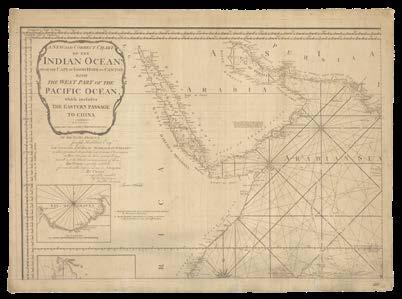
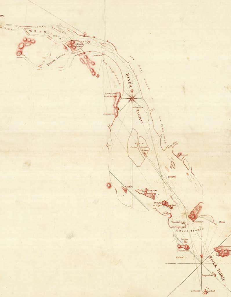
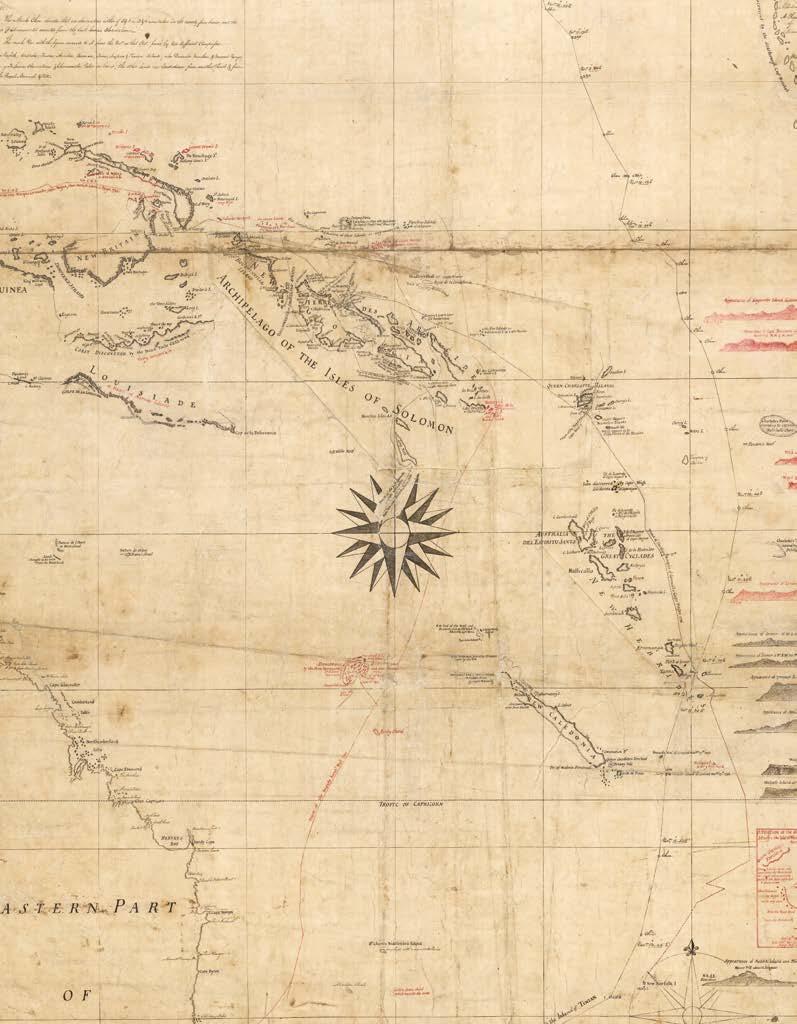
[SAYER, Robert]
[A New and Correct Chart of the Indian Ocean from the Cape of Good Hope to Canton; Including The Arabian and Persian Gulfs, The China Sea, The Oriental Islands, and the Western Part of New Holland: with all the Isles, Shoals and Dangers newly discover’d in these Seas... To my worthy friend Joseph Huddart, Esqr, Commander of the Royal Admiral, East Indiaman, to whose practical knowledge and accurate observations in these seas, and on their several coasts, as well as to his liberal communication of them, the public is greatly indebted for considerable improvements in navigation, this chart is respectfully inscribed by his affectionate humble servant Robert Sayer].
Publication [London, Robert Sayer, 53 Fleet Street, 1st. Jan.y 1787, but earlier].
Description
Large engraved chart on five sheets, copiously annotated in red ink throughout, with the addition of a border of neatlines and graticules, inset vignette maps, coastal profiles, tropics and rhumb lines, and corrections to place-names and other details, early repairs to verso with publisher’s waste, subsequent repairs with Japanese tissue.
Dimensions
Sheets one and two: 510 by 735mm (20 by 28.9 inches); sheets three and four: 530 by 730mm (20.8 by 28.7 inches); sheet five: 520 by 380mm (20.4 by 14.9 inches).
The progress of a chart - proof before sailing directions
Most of the details from Robert Sayer’s working manuscript (see item 114) have now been engraved and printed in black. However, in this proof the mapmakers have changed the vignettes that previously occupied central Africa: the inset of “Bombay Harbour” has been removed, leaving space for an eventual title-cartouche, the “Bay of Johanna” has been added, as has “False Bay” at the Cape of Good Hope. Further, some additional placenames have been supplied throughout the chart, and the rhumb lines have been redrawn.
The completed chart would be unveiled to the public on January 1st, 1787. It was then extended, later that same year, with an additional sheet to show the Eastern Coast of Australia (see item 203).
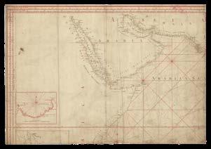
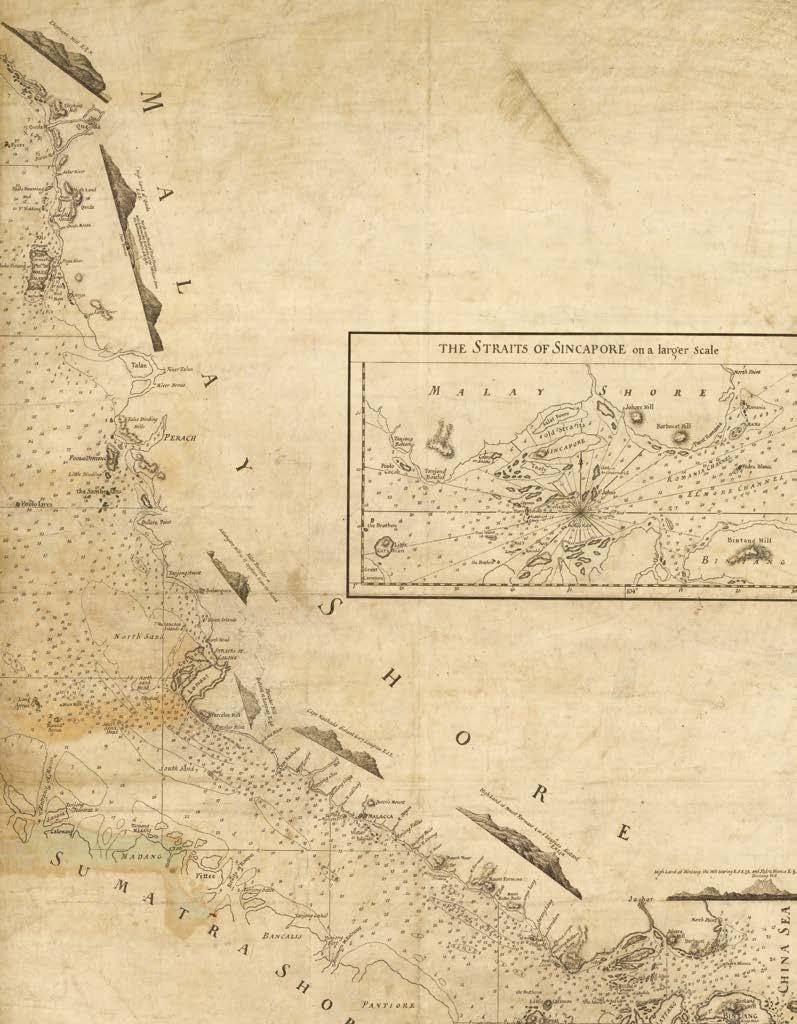
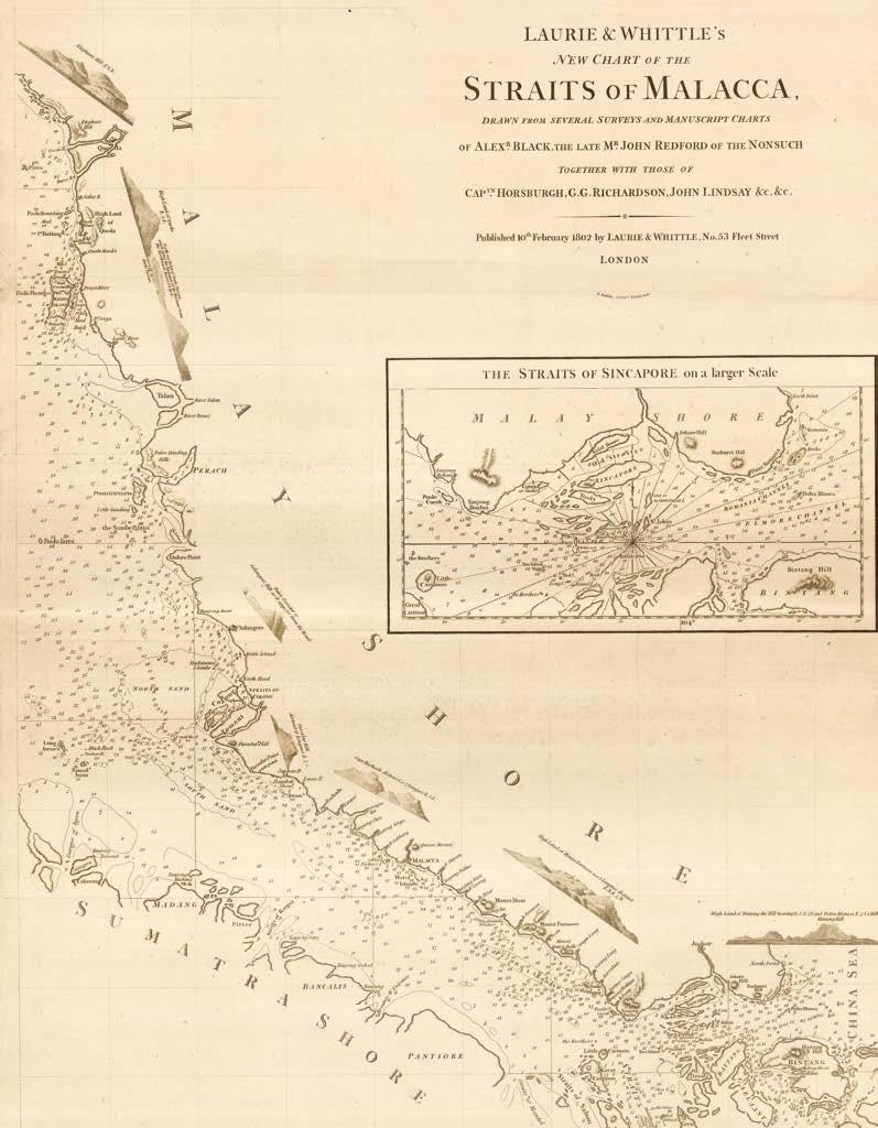
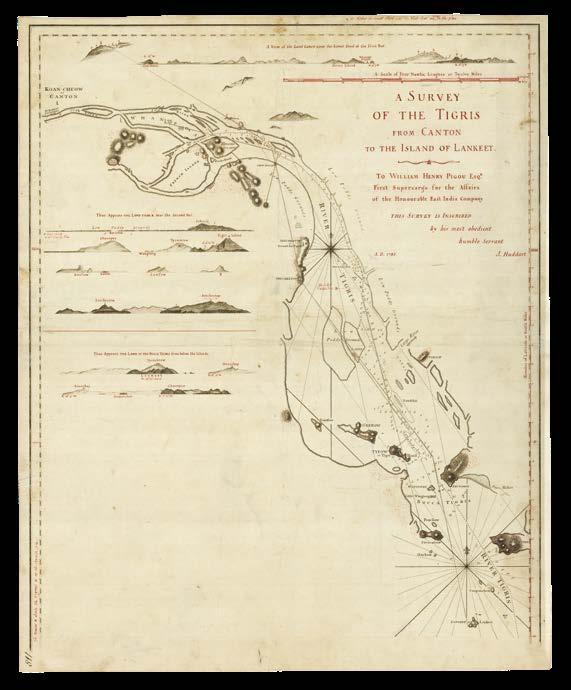
[LAURIE, Robert; and James WHITTLE; after Robert SAYER]
A New and Correct Chart of the Indian Ocean from the Cape of Good Hope to Canton with the West Part of the Pacific Ocean, which includes the Eastern Passage to China...To our worthy friend Joseph Huddart, Esqr, late Commander of the Royal Admiral, East Indiaman, to whose practical knowledge and accurate observations in these seas, and on their several coasts, as well as to his liberal communication of them, the public is greatly indebted for considerable improvements in navigation, this chart is respectfully inscribed by his affectionate humble servants Laurie & Whittle].
Revised office proof before re-printing, engraved chart on four separate sheets, with pen and red ink corrections, pencilled grid lines for copying, annotated lower right corner of each sheet “113 / 36”.
Dimensions
Sheets one, two, and three: 540 by 740mm (21.2 by 29.1 inches); sheet four: 540 by 1080mm (21.2 by 42.5 inches).
Revised office proof - including new information from the Baudin and Flinders expeditions
An interesting revised example of this monumental chart, first published by Robert Sayer on January 1st, 1787 (for which see items 114 and 115), but subsequently expanded by Laurie and Whittle from 1794, to include the eastern coast of Australia with relevant insets, and other amendments to 1800.
Manuscript annotations in red ink and pencil bring the date up to 1811, with the notation that a shoal east of the Cape of Good Hope, first noted in 1765, has been “seen again 1810”. The cartography of the
southern coastline of the mainland at “Bass’s Straits” incorporates information from Flinders’s charts (1811), and details from Nicolas Baudin’s voyage (1800-1804) along the coastline of South Australia are pencilled in from the “Bay of Saints” to the entrance to the Bass Strait. Otherwise, the chart remains in general shape and form the same as Robert Sayer’s original chart of 1787.
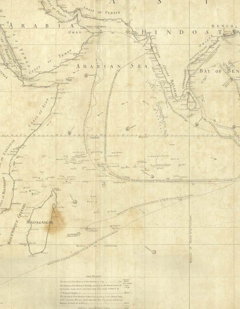
[LACAM, Benjamin]
Comparative Chart [of Indian Ocean].
Publication [London, c.1784].
Description Original working manuscript chart on two joined sheets, pen and black ink on paper.
Dimensions 525 by 645mm (20.75 by 25.5 inches).
Lacam’s route planner
A manuscript map by Benjamin Lacam, showing the northern half of the Indian Ocean.
The extensive chart spans the Indian Ocean from the Cape of Good Hope to the island of Sumatra with tracks comparing the different routes taken during the monsoons. In winter, the ocean current flows westwards from the Indonesian Archipelago across to the Arabian Sea, whereas in the summer, it flows eastward from Africa into the Bay of Bengal. Consequently, mariners were advised to alter their routes depending on the time of year.
Lacam, who is best-known for his protracted attempt to build and then defend a ‘New Harbour’ on the Hooghly River, shows a number of tracks across the Indian Ocean, for example: “from Madras to Mauritius during the contrary monsoon = 4020 miles”; “first track of Commodore James from Madras to Bombay in the months of September and October 1754”; “track from Bombay to Madras in the north-east monsoon - 3540 miles”; “track from Madras to Lacam’s Channel N.E. = 660 miles; to New Harbour = 710 miles”.
There are no soundings, and geographical information is limited to the names of cities and coastal regions, but maritime obstacles such as large sand banks are still shown.
The chart would be published by Laurie and Whittle in 1794 with an extensive dedication to King George III and an additional inset.
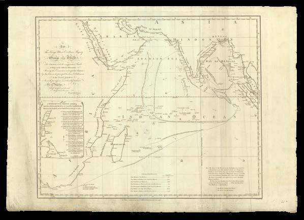
LACAM, Benjamin
To the King’s most excellent Majesty George the Third; this chart, with the comparative tracks of ships, in the different monsoons; shewing the connection and respective distances by sea, between the principal harbours & settlements in the East Indies; is with permission most humbly dedicated by His Majesty’s most dutiful and devoted subject and servant, Benjamin Lacam.
Publication London, Laurie and Whittle, 12th August 1808.
Description Engraved chart.
Dimensions 520 by 625mm (20.5 by 24.5 inches).
Making tracks
The 1808 printed edition of Benjamin Lacam’s comparative chart of routes through the Indian Ocean (item 117), first published in 1794. New tracks have been added “from Bombay to Madras as in the North East Monsoon” and “from Madras to Bengal in the N.E. Monsoon”, as well as a note warning that “the change of the monsoon in the East Indies, from south west to north east is generally attended with the most tempestuous weather”. There is an inset containing ‘a supplemental sketch exhibiting the sea engagements in the Bay of Bengal between the English and the French fleets from 1758 to 1783’, which is also found on the 1794 edition but not the original manuscript. A nine-point list describes various skirmishes between the rival fleets, their location symbolized on the chart by a small sword.
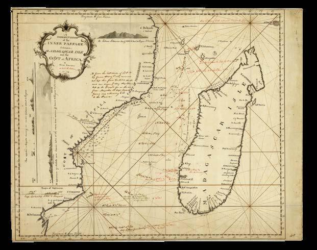
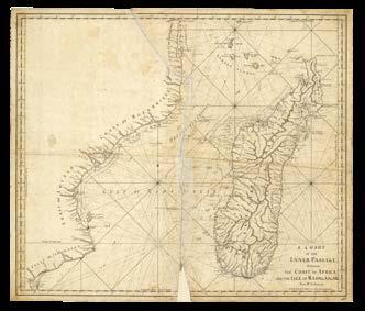
ROBERTSON, George
A correct chart of the Inner Passage between Madagascar Isle and Coast of Africa by George Robertson on board the Latham 1778.
Publication [London], 1778.
Description Original working manuscript map on three joined sheets, pen and black, red and green ink with grey wash, on paper, “Inner Passage” inscribed to verso.
Dimensions 435 by 545mm (17.25 by 21.5 inches).
The Inner Passage
The east coast of Mozambique is shown from Cabo Delgado to Delagoa Bay, now called Maputo Bay, with settlements and rivers identified and soundings given. The entire island of Madagascar appears, with rivers, bays, and ports named along its coast, but few soundings provided. Four views, two of which are drawn vertically, show the appearance of the land from the channel.
The tracks of the East India Company’s ‘Latham’ from 1777 and 1778 are shown, the first in black ink and the second in red. The ship’s observations and sightings are noted at various points, and a note describes the strong currents they experienced when approaching Calcutta. The ‘Latham’ set sail from Plymouth in February 1778 and returned to England in November 1779. Sadly, all the crew may not have returned: ‘The Scots Magazine’ of 1779 lists the death of a George Roberston at Madras, who may be the maker of this chart.
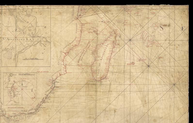
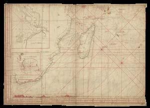
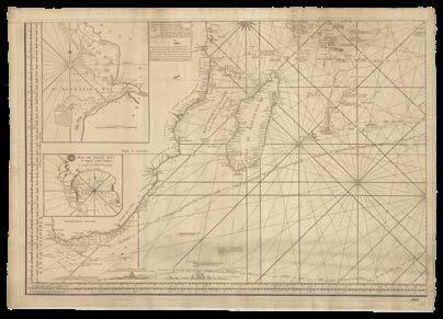
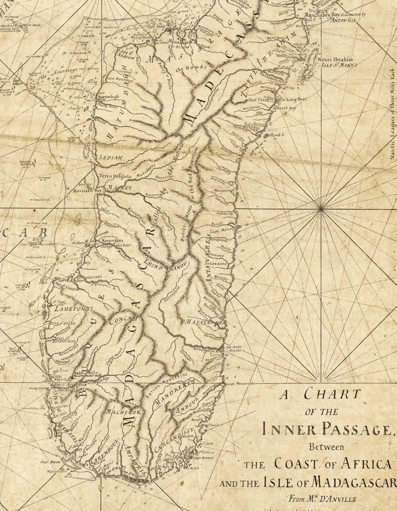
D’ANVILLE, [Jean-Baptiste Bourguignon, after]
A Chart of the Inner Passage, between the Coast of Africa and the Isle of Madagascar from Mr D’Anville with several editions and emendations [with: A Chart of the Comoro Islands / Foul Point and Bay on the East Side of Madagascar / The Bay of Johanna].
Publication [London, c.1790].
Description
Two original working manuscript charts on three sheets joined as two, pen and black ink on paper, damage to one sheet.
Dimensions
Sheet one: 630 by 735mm (24.8 by 28.9 inches); sheet two: 330by 310mm (12.9 by 12.2 inches).
Mozambique and Madagascar
A manuscript chart and three insets showing the Mozambique Channel and the whole of the island of Madagascar.
Based on a map made by Jean-Baptiste Bourguignon d’Anville, the chart has been updated with soundings and information about maritime obstacles, particularly around the west coast of Madagascar, although a note warns that “the soundings [are] very uneven”. Information from voyages up to 1771 are noted. On land, the rivers and mountains of Madagascar are well-described, while details about Mozambique are limited to the coastal regions. Uniquely, the maker has identified the body of water to the direct south of the channel as the “Gulf of Madagascar”.
On a separate sheet three insets have been prepared. The largest shows the Comoro Islands in the north of the channel, where the French colonial authorities had established numerous sugar plantations. The bay on the north side of the island of “Johanna”, now Ndzuwani, is shown in an additional inset, with soundings provided in the waters off “Governor’s Town”. Finally, the third inset shows ‘Foul Point and Bay on the east side of Madagascar’, where British ships had stopped before their victory over the French at the siege of Pondicherry in 1760.
The first printed edition of the chart, published by Robert Sayer in 1790, would bear some changes, with the three insets incorporated into the chart, the title amended, and much of the west coast revised.
D’ANVILLE, [Jean-Baptiste Bourguignon, after]
A Chart of the Inner Passage, between the Coast of Africa and the Isle of Madagascar from the charts of D’Anville and D’Apres compared with the draughts and journals of British navigators.
Publication London, Robert Sayer, January 1st 1790.
Description Engraved chart, with manuscript annotations in black ink.
Dimensions 625 by 720mm (24.5 by 28.25 inches).
“Madagascar does not extend S’SW’ enough”
The printed edition of the chart of Mozambique Channel, prepared in manuscript after the work of D’Anville (item 120).
While no changes have been made to the African coast, the west coast of Madagascar has been heavily revised, with more soundings added, the mouths of rivers drawn with greater precision and many of the shoals and sandbanks omitted. In the “Gulf of Madagascar”, where previously the “Bassas de India” were presented, there are now the “Europa Rocks, discovered in 1774, often mistaken for the Bassas”. The “track of the Speaker, Capt. Rob.t Scott in 1772” have also been added. Moreover, the three insets that earlier appeared on a separate sheet have been included in the upper left-hand corner of the chart.
In the lower margin, a manuscript note reads “Madagascar does not extend S’SW’ enough by more [crossed out] one degree 5 M. on Lat. 23.30”.
[ANONYMOUS]
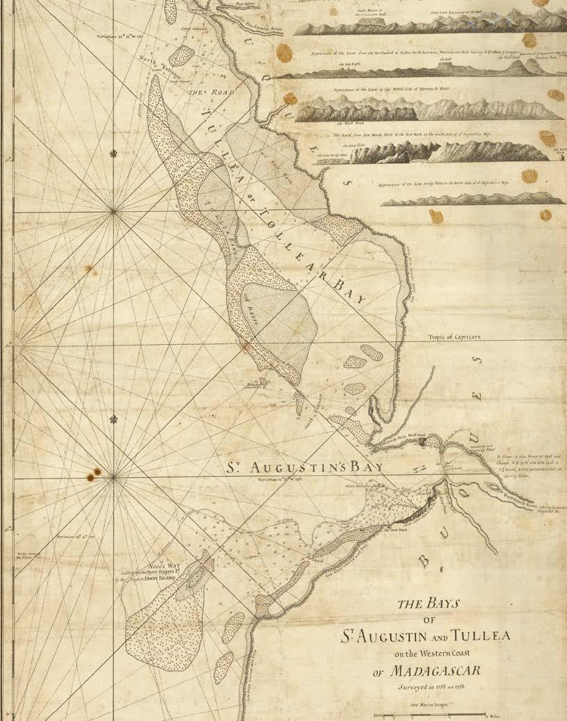
The bays of St. Augustin and Tullea on the western coast of Madagascar surveyed in 1755 and 1758.
Publication [London, c.1778].
Description Original working manuscript chart on two joined sheets, pen and black ink on paper, “Bay of St. Augustin and Tullia” inscribed to verso.
Dimensions 610 by 460mm (24 by 18 inches).
St. Augustin and Tullea
A manuscript chart of the coast of the western Madagascar in what is today the Atsimo-Andrefana region of the island.
The two principle harbours in this region are provided by “St. Augustin’s Bay” and “Tullea or Tollear Bay”, today Toliara. They are located either side of the mouth of the Onilahy River (“Dartmouth River called by the natives Onglahe R.”). Soundings, sand banks, reefs, anchorages, and “foul ground” are identified in the coastal waters, according to surveys conducted in the 1750s. The former survey was likely carried out when the ‘Stretham’, ‘Pelham’, ‘Edgecote’, and ‘Houghton’ East Indiamen docked at St. Augustin in 1755, and the latter by William Nichelson, the master of HMS ‘Elizabeth’, who landed in the bay three years later. Five coastal views in the upper right-hand corner show sailors how the land would appear to them from the sea.
The first printed edition of the chart would be published by Sayer and Bennett in their 1778 ‘The Oriental Pilot’.
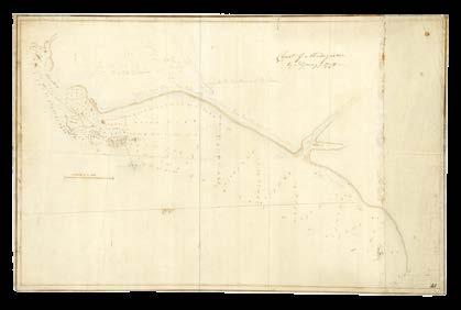
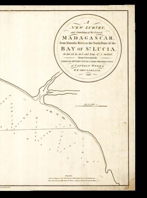
YOUNG, J[ohn]
Coast of Madagascar by J. Young 1798.
Publication [London], 1798.
Description Original working manuscript chart on two joined sheets, pen and black ink and pencil, on paper.
Dimensions 370 by 575mm (14.5 by 22.75 inches).
Saved by the ‘Star’
A manuscript map made by John Young, member of the crew aboard the HMS ‘Garland’, who spent five months stranded on Madagascar after the ship struck a rock in 1798.
After hitting the rock in pursuit of a French ship run ashore off Port Dauphiné, the ‘Garland’ swiftly sank and her crew only narrowly escaped in the lifeboats. All was not in vain, however, as Captain James Athol Wood convinced the natives to hand the Frenchmen over to the British, and kept them as prisoners-of-war while waiting for rescue, which eventually came in the form of the sloop-of-war ‘Star’. While the ‘Star’ carried the prisoners to Île de France, Wood and his crew returned to the Cape of Good Hope in a small boat they had built on Madagascar.
Young’s map shows “St. Lucie” where the crew settled during their five-month wait for rescue, and describes the “lake to the westward of the town”, and a “thick wood like a box hedge with breaks here and there that the inhabitants come through”. The river, he states, offers suitable passage only for canoes. He also makes a remark that “about 6 leagues to the northward of Bird Island lies a very dangerous reef”. While there are no longitude or latitude scales, Young has written out the coordinates of “Little Island”, and provides a mile scale and compass lines.
Pencil rubbing on verso along coastline for transferring chart.
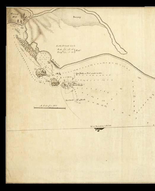
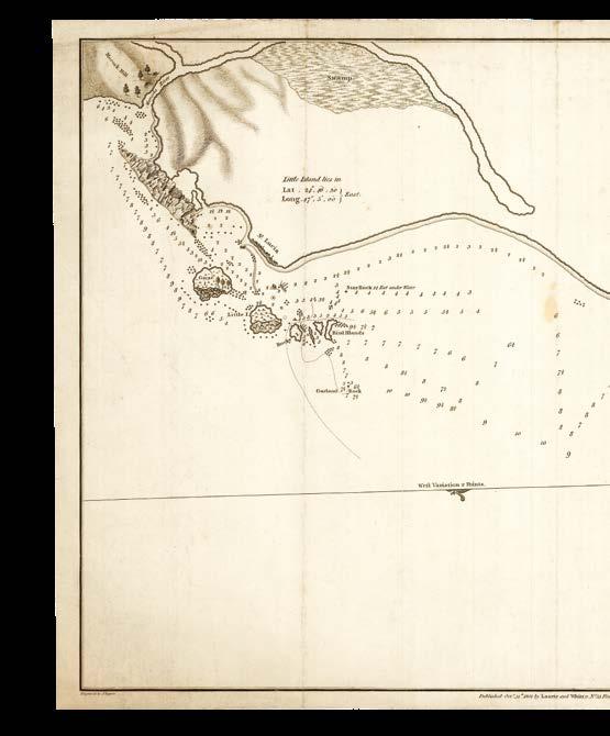
YOUNG, John
A new survey and soundings of the Coast of Madagascar from Manafia River, to the North Point of the Bay of St. Lucia. in the Lat[itude] 24.46’30” So. and Long[itu]de. 47.5’00” East, from Greenwich, taken by Mr. Jo.n Young under the Direction of Capt[ai]n Wood of H.M. Ship Garland, 1798.
Publication [London], 1798.
Description Original working manuscript chart, pen and black ink on paper.
Dimensions 370 by 565mm (14.5 by 22.25 inches).
The fair copy of John Young’s manuscript chart of Madagascar, where he was stranded after the HMS ‘Garland’ sunk.
The route of the ‘Garland’ as she approached the shore and then struck the “rocky island” has been added to the map, while Young’s comments about the thick wood and the canoes on “Bullock River” have been omitted. The chart would be published in print in 1801.
Young’s
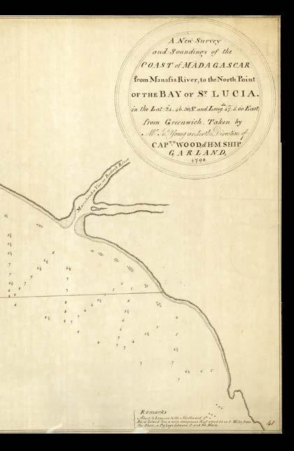
YOUNG, John
A new survey and soundings of the Coast of Madagascar from Manafia River, to the North Point of the Bay of St. Lucia. in the Lat[itude] 24.46’30” So. and Long[itu]de. 47.5’00” East, from Greenwich, taken by Mr. John Young under the Direction of Capt[ai]n Wood of H.M. Ship Garland, 1798.
Publication London, Laurie and Whittle, October 31st 1801.
Description Engraved chart.
Dimensions 385 by 590mm (15.25 by 23.25 inches).
The first printed edition of John Young’s chart of part of southern Madagascar, where he had been stranded in 1798. The only difference between the final printed version and the office fair copy (item 124) is that the scale bar has been moved under the circular title cartouche.
“number of tortoishells, that appear like sheep feeding”
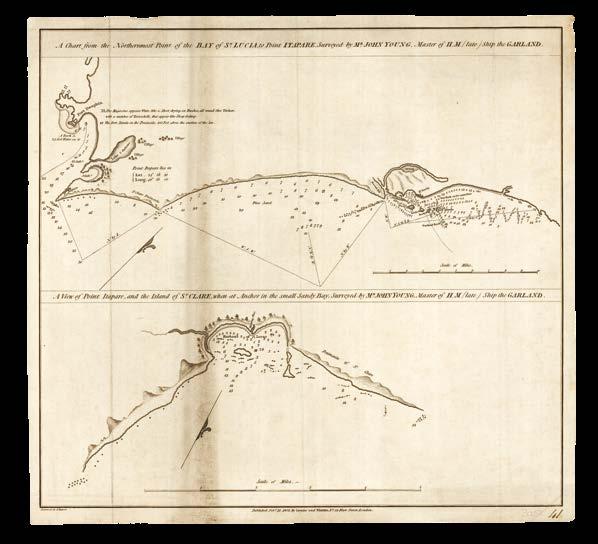
YOUNG, John
A chart from the northermost part of the Bay of St. Lucia to Point Itapare, surveyed by Mr. John Young, Master of H.M. (late) Ship the Garland [with:] A view of Point Itapare, and the island of St. Clare, when at anchor in the small sandy bay, surveyed by Mr. John Young, Master of H.M. (late) Ship the Garland.
Publication
London, Laurie and Whittle, Oct[obe]r 31 1801.
Description
Two original working manuscript charts on two joined sheets, pen and black ink on paper, “Coast of Madagascar by Mr. Young” inscribed to verso.
Dimensions
400 by 430mm (15.75 by 17 inches).
A smaller scale survey by John Young showing the Madagascan coast from Fort Dauphin to “St. Lucia”, where the crew of the “late ship the Garland” were stranded.
Understandably, the waters off the coast of “St. Lucia” are described in the most detail, with rocks, islands, and soundings provided. Soundings are consistently, though less precisely, provided along the coast to Fort Dauphin, where Young identifies three villages and rather poetically observes that “the magazine appears white like a sheet drying on bushes, all around fine verdure, with a number of tortoishells [sic], that appear like sheep feeding”.
The lower half of the sheet offers a larger-scale chart-cum-view of “Point Itapare”, with soundings in the “Harbour of Locar” flanked by horizontal views of the undulating landscape. A “watering place” is identified in the harbour. Young claims to have executed the views while “at anchor in the small sandy bay”; he may have been on board the boat constructed by the stranded crew of the ‘Garland’ during their unintended five-month stay on Madagascar.
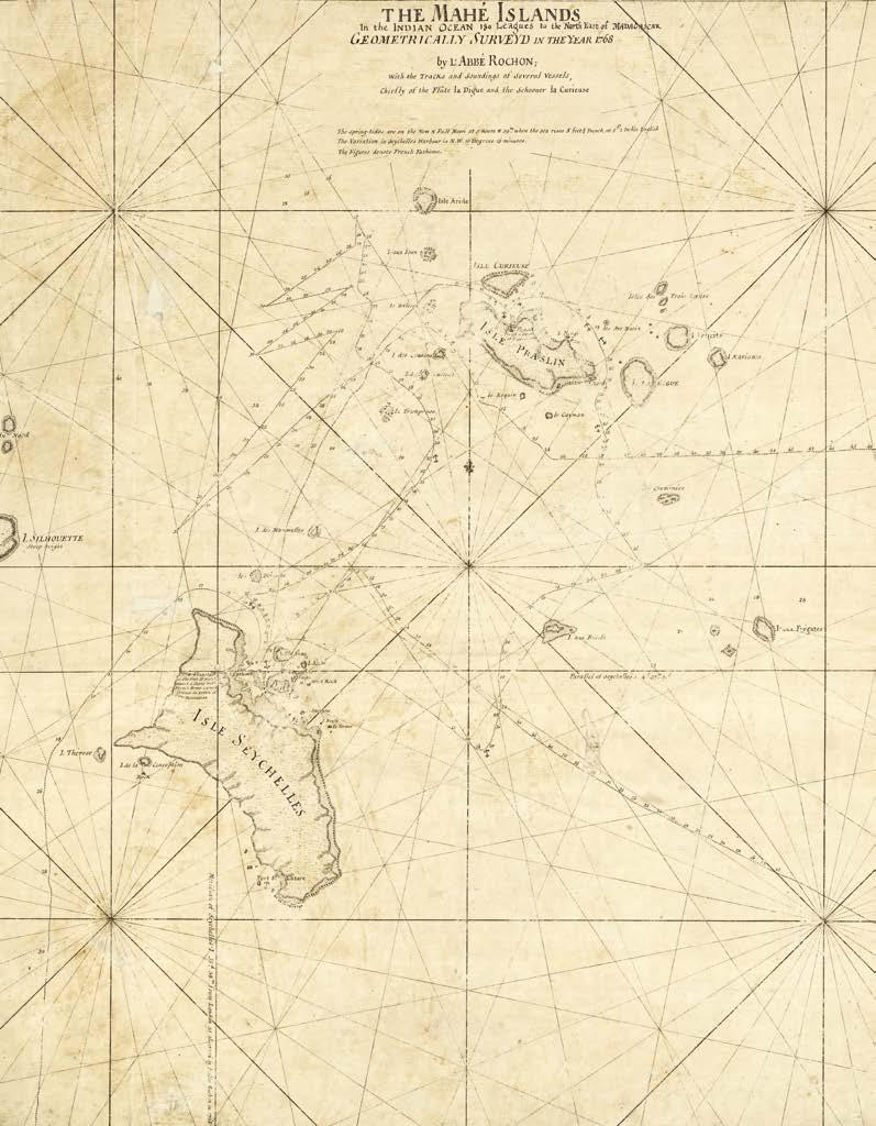
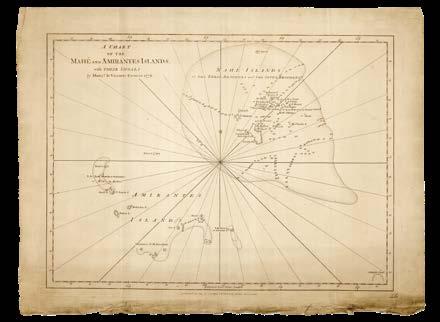
[HASELL, Captain John; after] L’Abbé ROCHON
The Mahé Islands in the Indian Ocean 180 leagues to the North East of Madagascar geometrically surveyd in the year 1768 by l’Abbé Rochon; with the tracks and soundings of several vessels, chiefly of the Flûte la Digue and the Schooler la Curieuse.
Publication [London], 1768 [but c.1778].
Description Original working manuscript chart, pen and black ink on paper, “The Mahe Islands” inscribed to verso.
Dimensions 580 by 525mm (22.75 by 20.75 inches).
The Seychelles, redrawn
A manuscript chart of the Seychelles, drawn after the work of L’Abbé Rochon as communicated through a number of British sources.
The printed edition of the chart was published in 1778 by Sayer and Bennett in ‘The East India Pilot; or oriental navigator’, with the name of Captain John Hasell added to the title. Hasell captained a voyage of the Duke of Portland East Indiaman, which arrived in the Indian Ocean in December 1770 and remained there for almost one year. This chart, being hydrographically identical to that copied from Captain Philip Pittman by Lieutenant Charles Turner in 1771 (item 128), may have been redrawn by Hasell in preparation for publication, and here has grid lines, rhumb lines, and latitutde scales added, and the title changed and moved.
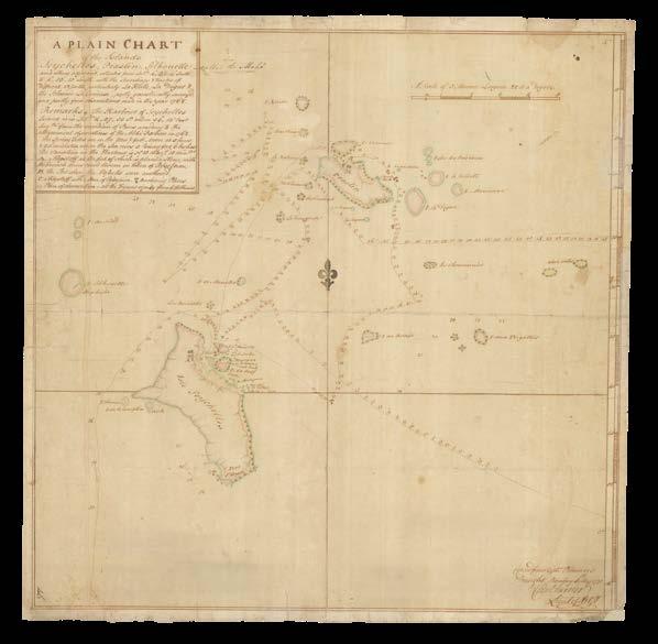
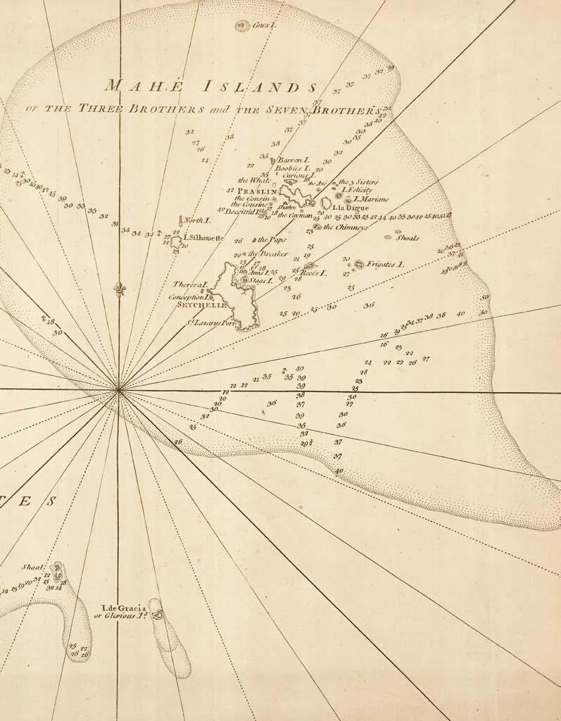
A plain of the Islands Seychelles, Praslin, Silhouette and others adjacent situated from Lat[itu]de. 430’ South to 4 50’ 15” South, with the sounding and tracks of different vessells, particularly La Flute, La Digue & the Schooner La Curieuse, partly geometrically survey’d and partly from observations made in the year 1768...copied from Capt[ai]n Pitman’s draught, Bombay 5th May 1771, Charles Turner, Lieut[enant] of Art[illery] 7.
Publication Bombay, 5th May 1771.
Description Original manuscript chart, pen and black ink and colour wash on paper, “Seychelles Praslin Silhouette” inscribed to verso, minor soiling and loss to border.
Dimensions 550 by 545mm (21.75 by 21.5 inches).
Seychelles sea shells on the sea shore
A manuscript chart of the Seychelles, drawn in Bombay, now Mumbai, in 1771.
The chart is based on a survey by French astronomer and physicist Alex-Marie de Rochon, who had spent two weeks in the Seychelles in June 1769. Soundings are given along the tracks of the two French vessels whose voyages are shown: ‘la Curieuse’ and ‘la Digue’. Both visited the islands in 1766 as part of the expedition led by privateer and explorer, Marc-Joseph Marion du Fresne. Du Fresne, who later made his home on Mauritius and was eventually killed by Maoris in New Zealand, brought back to France a specimen of giant tortoise and coconuts from the Seychelles.
Few topographic details are given on the islands: the port of “St Lazare”, named after Lazare Picault who landed there in 1742, is identified on the southern coast of the largest, Mahe, while most of the islands in the surrounding water are simply presented as named rocks. 30 miles northeast of Mahe, the more significant islands of Praslin, La Digue, and Curieuse, which still bear the same names, are shown. Furthermore, there are no rhumb lines, longitude or latitude scales, or grid lines. The chart was drawn by Lieutenant Charles Turner of the 7th Artillery from a draft made in around 1770 by Captain Philip Pittman, who had earlier produced a map of the European settlements in Mississippi while based in America in the 1760s.
This chart, amended by Captain John Hasell, would appear in Sayer and Bennet’s ‘The East India Pilot; or oriental navigator’ in 1778.
GRENIER, Victomte
A chart of the Mahé and Amirantes Islands, with their shoals, by Mons[ieu]r le Vicomte Grenier 1776.
Publication London, Laurie and Whittle, 12th May 1803.
Description Engraved chart.
Dimensions 450 by 605mm (17.75 by 23.75 inches).
The Seychelles and Amirantes Islands
A chart of the Seychelles and Amirantes Islands, published when Britain was securing its naval control over the region against the incursions of the Napoleonic forces.
The chart has been updated since the survey of Grenier in 1776, on which it is based. Although there are no tracks shown or ships named, the soundings given around the many islands of the Seychelles have been added based on surveys undertaken since Britain took control of the islands in 1794.
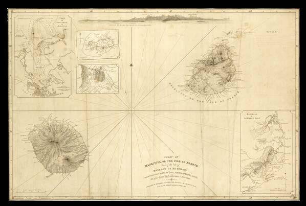
[ANONYMOUS]
Chart of Mauritius or the Isle of France, and of the Isle of Bourbon or Re-union; with particular plans of Port-Northwest or Port Louis, and of Le Grand Port or Port Bourbon in Mauritius.
Publication London, Laurie and Whittle, 1st December 1810.
Description Original working manuscript chart on three joined sheets, pen and black and red ink, with two pasted overslips, on paper.
Dimensions 615 by 940mm (24.25 by 37 inches).
Mauritius minds
A manuscript chart of Mauritius and Réunion.
Prepared for December 1810, the chart shows two islands that were then under British control, albeit unbeknownst to the makers. Britain had wrested control of Mauritius from France at the Battle of Grand Port (“Grand Port or Port Bourbon or South-east Port”) in August 1810. Not yet knowing of the victory, the makers continue to refer to the island as “the Isle of France”. Although the near-simultaneous French capitulation at Réunion resulted in the island regaining its pre-Napoleonic name of “Bourbon”, this does not result in any anachronisms on the present chart: it seems that the British mapmakers had.
The coasts of both islands are shown in detail, although soundings are very scarce. The inland area of Mauritius is mapped in greater detail, and two insets show the ‘Environs of Le Grand Port’ and a ‘Plan of Port Louis in Mauritius’. Two additional insets have been pasted on overslips, one showing the smaller island of Rodrigues (“Rodrigue”) to the east, and the other the ‘Environs of St. Denis’, the capital of Réunion.
Along the upper edge of the chart is a view showing the “appearance of the northwestern coast of Mauritius, in the environs of Port-Louis”, and space has been left for “remarks” to the right. Additional edits have been made in red ink, including the crossing-out of several toponyms and instructions to rearrange the title. Indeed, when the printed map was published the following year the title would be amended in accordance with these directions.
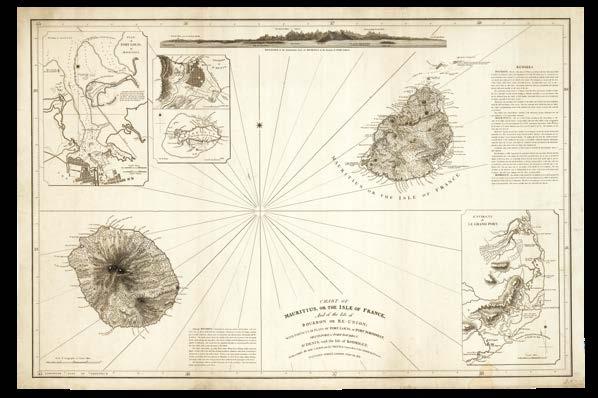
[ANONYMOUS]
Chart of Mauritius or the Isle of France, and of the Isle of Bourbon or Re-union; with particular plans of Port Louis or Port-Northwest, Grand Port or Port Bourbon, St. Denis, and the Isle of Rodrigue.
Publication London, Laurie and Whittle, Feb[ruar]y 26 1811.
Description Engraved chart on three joined sheets.
Dimensions 655 by 975mm (25.75 by 38.5 inches).
A printed example of the chart of Mauritius and Réunion updated with the changes and additions made in 1810 (item 130).
The two insets have been incorporated into the upper left-hand corner of the chart, and the toponyms crossed out in red have been removed. The space left for “Remarks” has been filled with notes about Mauritius, Réunion, and Rodrigues; a further note besides Réunion discusses its fertile soil and increasing population, which it gives as “16400 Europeans and Creoles: 3496 Free Blacks: 70450 Slaves”. In February 1811, the makers still appear to be unaware that the two islands shown were then under British control. A chart with census statistics
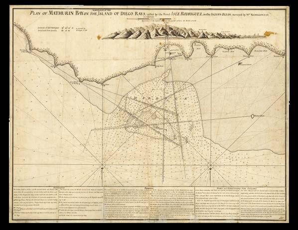
NICHELSON, W[illia]m
Plan of Mathurin Bay on the north side of the island of Diego Rays, called by the French Isle Rodriguez, in the Indian Ocean; surveyed by W[illia]m Nichelson in 1761.
Publication [London], 1769 [but c.1778].
Description
Original working manuscript chart on two joined sheets, pen and black ink on paper, “Mathurin bay” inscribed to verso.
Dimensions 520 by 670mm (20.5 by 26.5 inches).
Diego Rays
The fair copy of a chart of Isles Rodrigues, or “Diego Rays”, one of the Mascarene Islands in the Indian Ocean, ready for the engraver.
The chart is based on one made by Jean-Baptiste d’Après de Mannevillettee and included in his 1745 ‘Neptune Oriental’; it has been updated with information garnered by Captain William Nichelson on his surveying expedition of 1761. Nichelson was master of the HMS ‘Elizabeth’, and also produced an eight-sheet chart of Bombay Harbour in 1763. The island’s coordinates are included “as observed by Mr Pingré in 1769”.
Mathurin Port on the north side of Isle Rodrigues is shown to have “a flat sandy beach”, “watering place”, “store house”, and “the French Governor’s house”. During the eighteenth century the French attempted to develop the island with farms worked by African slaves; British troops would seize the island after a brief battle in 1809 and abolish slavery there in 1834. Soundings and obstacles are identified in the sea around Mathurin Port, and annotated lines suggest different routes to and from the shore.
A view from the water shows the “appearance of the Island when you are a little without the middle ground”. Along the lower edge of the chart are three boxes of text: the first provides references and keys for the symbols and letters that appear on the chart; the second contains remarks about navigating the waters around the island; the third gives information about “tides and directions for sailing”.
The printed chart was published in ‘The East India Pilot’ of 1778 with no changes.
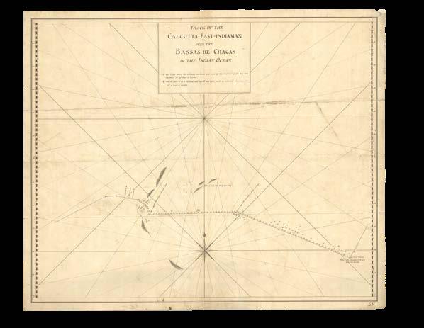
[ANONYMOUS]
Track of the Calcutta EastIndiaman over the Bassas de Chagas in the Indian Ocean.
Publication [London, c.1794].
Description
Original working manuscript chart on two joined sheets, pen and black ink on paper, “Bassas de Chagas” inscribed to verso, some repairs and minor staining.
Dimensions 480 by 585mm (19 by 23 inches).
The mystery of the Calcutta
A manuscript chart showing part of the Chagos Archipelago in the Indian Ocean, around 300 miles south of the Maldives.
Although discovered by Portuguese explorers in the early-sixteenth century, the isolated group of seven atolls in the Indian Ocean attracted little attention, and were never absorbed into the extensive Portuguese Empire. Indeed, contemporary documents show that the King of the Maldives clearly considered the islands to be his property. Nonetheless in the mid-eighteenth century the French claimed the archipelago, and from the 1770s began to issue permits allowing the establishment of coconut oil plantations there, which did not stop the British from seizing them for themselves the following decade.
In April 1786, the British East India company attempted to establish a base on Diego Garcia, the largest island of the group, but left the following October when supplies proved insufficient to maintain the small colony. Upon their departure French Mauritius began to use the island effectively as a site of exile for lepers, and later established a coconut plantation there, worked by slaves.
Around this time, the present chart was made, showing the course of the ‘Calcutta’ East Indiaman. In crossing the Indian Ocean, the ship passed through the Chagos Archipelago and, according to the chart, first saw three islands, and twice cast anchor, first to make “observations of the Sun and Moon” and then “celestial observations”. The “A” identified in the key as representing the first anchorage has been omitted from the chart, an error retained on the printed map. Furthermore, next to its anchor symbol by the “West Part of the Shoal”, there appears a sounding of “5” that does not appear on any of the printed editions of the chart.
The first printed edition of the chart appeared in Sayer and Bennett’s ‘Oriental Pilot’ of 1778. Mysteriously, the only East Indiaman named the ‘Calcutta’ was launched in 1788, and the two voyages it made through the Indian Ocean, both under Captain Henry Wilson, occurred in 1789-1790 and 1793-1794. Earlier EIC ships did sail the same route, but the chart’s title and notes (“where the Calcutta first got upon the Bassas”; “where the Calcutta anchored”) demonstrates that the course of a specific vessel is recorded here.
In 1794, Laurie and Whittle reissued the chart with no new information added. Institutional examples of the 1778 and 1794 editions are to be found only at the Biblioteca Nacional de España and the National Library of Australia.
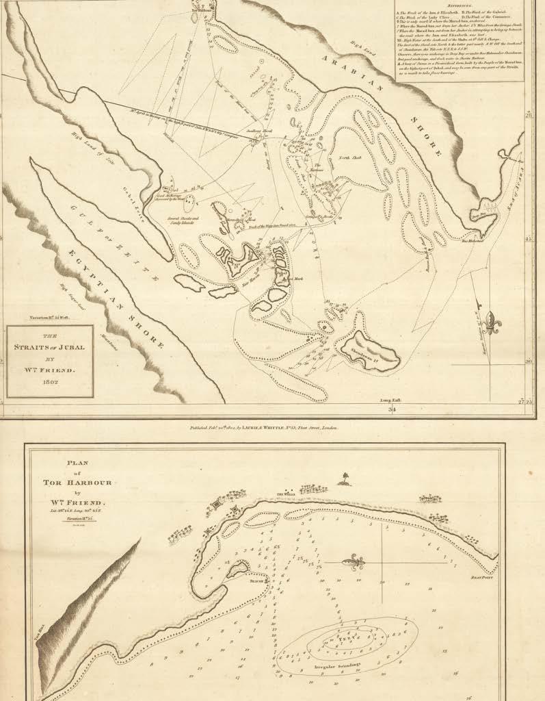
FRIEND,
William
The Straits of Jubal by W[illia]m Friend, 1802 [with] Plan of Tor Harbour by W[illia]m Friend.
Publication London, Laurie and Whittle, Feb[ruar]y 20th 1804.
Description
Two original working manuscript charts on two joined sheets, pen and black ink on paper, “Straits of Jubal & the Drawing of W. [?]Cantillon corrected to 1804” inscribed to verso.
Dimensions 590 by 440mm (23.25 by 17.25 inches).
Two charts showing the waters of the Straits of Jubal in the Red Sea and Tor Harbour.
The tracks “of the Wasp Gun Vessel 1802” and “of the Murad-bux” are shown, and the wrecks of the ‘Ann’, ‘Elizabeth’, ‘Gabriel’, ‘Lady Clive’, and ‘Commerce’ are identified by key. Soundings are provided along parts of the tracks shown, and “several shoals and sandy islands” and other obstacles are identified between the Egyptian and “Arabian shore”.
On the lower-half of the sheet a ‘Plan of Tor Harbour’, the base from which the British launched its surveying expeditions in the Red Sea, provides more detailed soundings. Friend has also identified wells and temporary settlements on the shore, as well as a “beacon” in the shallows.
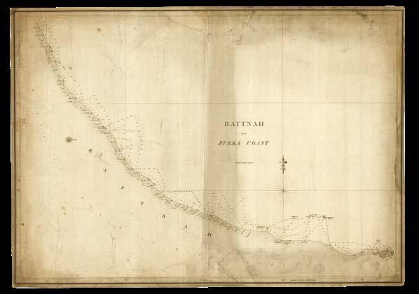
HORSBURGH, James
Battnah or Burka Coast.
Publication [London], James Horsburgh, 1831.
Description
Engraved chart on two joined sheets, laid on linen, pasted slip to verso with manuscript list of artistic works.
Dimensions 535 by 750mm (21 by 29.5 inches).
On the Gulf course
A chart of the Gulf of Oman extending from Al Mirayr (“Maharae”) to Muscat.
From 1820 to 1829, the Bombay Marines undertook an extensive survey of the Gulf of Oman, the results of which were used to produce numerous charts. East India Company hydrographer James Horsburgh published this chart in 1831, showing the southern stretches of the waters along the northwestern coast of Oman, in the Al Batinah region. Villages, towns, and cities - namely Suhar (“Sohar”) and Muscat - are shown along the shore, decked with palm trees, alongside other smaller towns and villages, and a “ruined fort”. Further inland, however, the region is devoid of any topographical information, and simply labelled an “extensive track of hilly country”. Soundings are provided close to shore, and certain major maritime obstacles such as the “Damaniatte Rocks” (Jazair Daymaniyat), are identified.
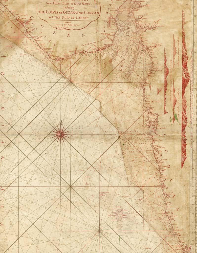
[ANONYMOUS]
The coast of India from Point Jigat to Cape Ramas, including the Coasts of Guzurat and Concan, with the Gulf of Cambay.
Publication London, Robert Sayer, [post-1785].
Description
One engraved chart on one sheet, sometime folded, and laid down on heavy paper, with extensive manuscript annotations in red ink on pasted overslip, with further pasted overslip along upper and lower margins.
Dimensions 625 by 465mm (24.5 by 18.25 inches).
Sayer and Bennett’s 1778 ‘Oriental Pilot’ contained a chart of India’s north-western coast, spanning what are now the states of Gujurat and Goa. The chart was entitled ‘The Coast of India from Gyants Point to Cape Rama, Comprehending the Coasts of Guzurat, Concan and Deckan, with the Gulf of Cambaya’ and appears to have been based on that published in 1758 by William Herbert. With the support of the EIC, Herbert compiled and disseminated the Company’s hydrographic materials in the mid-eighteenth century.
The present example of 1778 chart has extensive changes made by hand in red ink on pasted overslips, so that the only parts of the original map still visible are the rhumb lines and compass rose. The title of the chart has been changed, moved and housed within a cartouche, and the five views of the land from the sea are now shown vertically. Many toponyms have been added along the coast, in addition to updated soundings in the waters of the Arabian Sea. A longitude scale has also been added along the upper and lower margins. Several sandbanks have been grouped into a single “Angria’s Bank”, named after Admiral Kanhoji Angre (1669-1729) of the Maratha Navy.
The imprint states that the updated chart would be published by Robert Sayer, indicating a date of post-1785, as it was in this year that Bennett’s name was dropped following his admission to a mental asylum. Sayer, however, does not appear to have published the chart with the changes shown here. The earliest printed example of the updated chart instead seems to have been published by Laurie and Whittle in 1794.
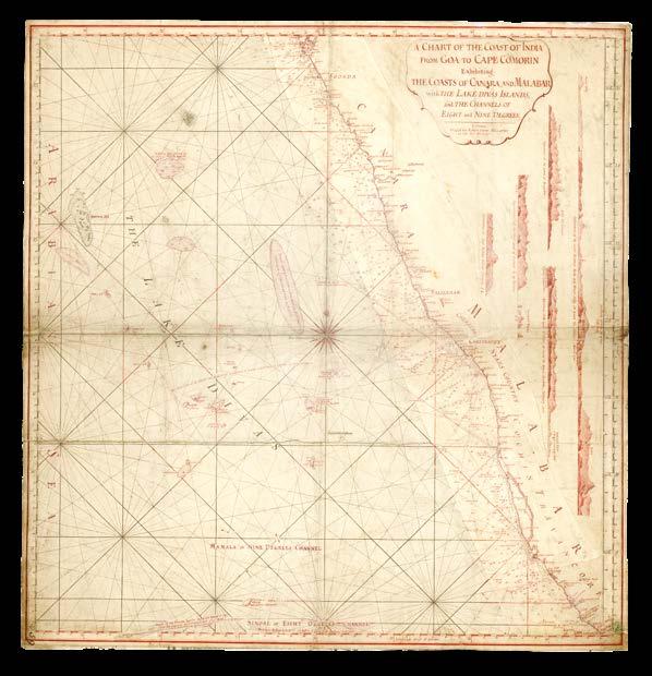
[ANONYMOUS]
A chart of the coast of India from Goa to Cape Comorin exhibiting the coasts of Canara and Malabar with the Lake-Divas Islands, and the Channels of eight and nine degrees.
Publication London, Robert Sayer, [c.1793].
Description Engraved chart on two joined sheets, with manuscript annotations in red ink on extensive pasted overslips, backed onto another chart.
Dimensions 640 by 615mm (25.25 by 24.25 inches).
Sayer and Bennett’s 1778 ‘Oriental Pilot’ contained a chart of the west coast of India entitled ‘The coast of India from Goa to Cape Comorin: comprehending the coasts of Canara and Malabar’. That chart has here been heavily updated by hand for Laurie and Whittle’s 1794 publication. A longitude scale has been added in the upper and lower margins, and almost the entire coast has been redrawn. Toponyms have been edited, added, and omitted, and soundings have been updated. A large new sandbar has been drawn off the coast of Mangalore.
The Laccadive Islands (“The Lake-Divas”) have also been redrawn; in 1792 the EIC agreed to the islands remaining under the rule of the Indian Cannanore Kingdom in exchange for a yearly tribute of 15,000 rupees. The updated information about the islands possibly came as a result of this negotiation. Six of the ten land profiles that appeared on the original chart have been retained, but redrawn vertically.
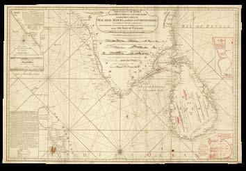
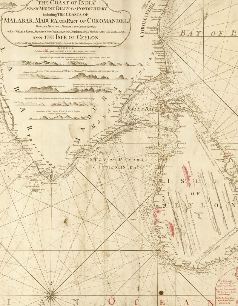
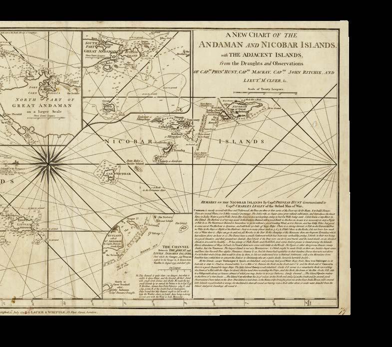
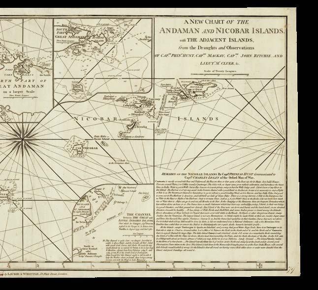
LEWIS, Lieu[tenan]t George; and Lieu[tenan]t Jo[seph] MCCLUER
The coast of India from Mount Dilly to Pondicherry, including the coasts of Malabar, Madura and part of Coromandel from the draughts, remarks and observations of Lieu[tenan]t George Lewis, Superint[enden]t and Commander of the Prudence Armed Ordnance Store Ship, in 1782 and 1783, with the Isle of Ceylon, and several useful additions from the survey made by order of the East India Company in 1790 by Lieu[tenan]t Jo[seph] McCluer.
Publication London, Laurie and Whittle, 12th May 1794 [but] September 1798.
Description Engraved chart with manuscript annotations in red ink.
Dimensions 605 by 910mm (23.75 by 35.75 inches).
Updates to Sri Lanka
A magnificent chart of the southern point of India and the island of Sri Lanka, first published in 1794 and here with manuscript updates in preparation for the 1798 edition.
The chart shows India from the Ezhimala hills, which the British knew as “Mount Dilly or Dilla” from the Portuguese ‘Monte d’Eli’, to the Coromandel coast on the Bay of Bengal. There are numerous views of the land, as seen from the ocean, and maritime obstacles and soundings are provided for the whole coast. ‘The coast from Tillicherry to Bayapore’ is shown in greater detail in an inset to the upper-left, beneath which the “remark on Cape Comorin and the Gulf of Manara by Lieut[enan]t George Lewis” provides navigational advice and instruction. Besides these remarks the islands of the Maldives appear, although no soundings are provided.
The whole of Sri Lanka (“Isle of Ceylon”) is shown. While there are no manuscript updates to the mainland or Maldives, several annotations and two new inset charts give details about the British conquest of Sri Lanka, which had taken place in 1796. The insets show the tracks of the HMS ‘Diomede’ and ‘Heroine’, both of which had been involved in the conquest; new soundings are offered off the coast of Colombo, and two additional views show the appearance of the land from the water. These changes would be incorporated in print when the map was published in 1798.
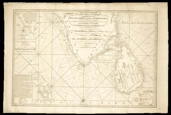
LEWIS, Lieu[tenan]t George; and Lieu[tenan]t Jo[seph] MCCLUER
The coast of India from Mount Dilly to Pondicherry, including the coasts of Malabar, Madura and part of Coromandel from the draughts, remarks and observations of Lieu[tenan]t George Lewis, Superint[enden]t and Commander of the Prudence Armed Ordnance Store Ship, in 1782 and 1783, with the Isle of Ceylon, and several useful additions from the survey made by order of the East India Company in 1790 by Lieu[tenan]t Jo[seph] McCluer.
Publication
London, Laurie and Whittle, 12th September 1798 [with manuscript updates to 1807].
Description Engraved chart, with manuscript annotations in pencil, “To be shewn to Messrs Laurie & Whittle” inscribed to verso in black ink.
Dimensions 610 by 910mm (24 by 35.75 inches).
Modifying the Maldives
The 1798 edition of Laurie and Whittle’s chart of the northern Indian Ocean, with yet more manuscript edits.
The annotations made in red ink to the 1794 edition (item 138) have all been adopted with the exception of the inset of Pigeon Island, which showed the tracks of the HMS ‘Diomede’ before it struck a rock and sunk, delaying the invasion of Trincomalee by a day. Perhaps the makers hoped to cover up the fact that the charts on board the ‘Diomede’ had shown the rock in question as being located half a mile further north than it actually was!
Additionally, there are numerous manuscript notes in pencil, likely made by a sailor, while using it, it spotted errors in the charting of the Maldives and the Bay of Bengal. The editors adds his sightings made in June 1807, with a note to the verso stating that these are “to be shewn to Messrs Laurie & Whittle”.
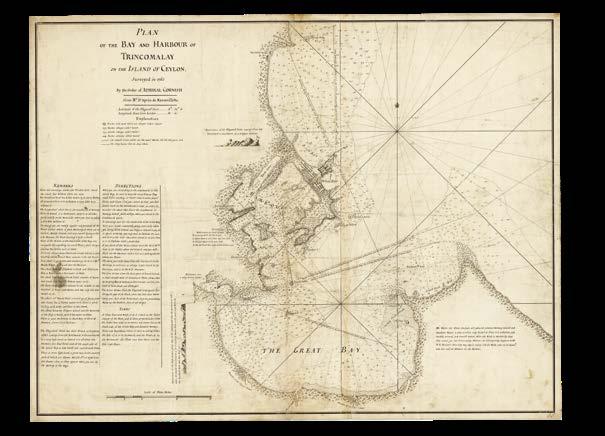
CORNISH, Admiral [Samuel; [after] D’APRÈS DE MANNEVILLETTE, [JeanBaptiste]
Plan of the Bay and Harbour of Trincomalay on the Island of Ceylon Surveyed in 1762 by the order of Admiral Cornish from Mr. D’Après de Mannevillette.
Publication [London], 1762 [but c.1778].
Description
Original working manuscript chart on two joined sheets, pen and black ink on paper, “Trincomalay” inscribed to verso, some repairs and minor staining.
Dimensions 555 by 730mm (21.75 by 28.75 inches).
“the most valuable colonial possession on the globe”
A magnificent manuscript chart of Trincomalee (“Trincomalay”), in eastern Sri Lanka (“Ceylon”), which was established as a fortified port town in the early sixteenth century due to its large and secure harbour, and which was described during the period of British rule as “the most valuable colonial possession on the globe”.
The chart is derived from those prepared by French hydrographer Jean-Baptiste d’Après de Mannevillette for his ‘Neptune Oriental’ of 1745 and updated with information garnered by a survey led by Admiral Samuel Cornish in 1762. Included are two views: ‘Appearance of the Flagstaff Point coming from the northward of southward’ and ‘Appearance of the high land a great way in the country’. Soundings provide bathymetric information for navigators, and potential obstacles are represented pictorially and then identified in the explanation as, for example, “sands always under water” or “rocks always above water”.
A note to the south advises sailors that good anchorage is to be found between Norway Island and the Sambore River when monsoon season makes the harbour inaccessible: “here they may lay in safety t’ill the wind comes to the eastward, and then sail at pleasure for the harbour”. Further notes along some of the rhumb lines offer further instruction. There are no tracks of famous voyages in the sea, or records of any of the numerous skirmishes that took place there during the colonial period.
On the promontory that provides the harbour’s shelter is Fort Fredrick (“Great Fort”), which was held by the Dutch in 1662, and three years later would be rebuilt to defend against British and French attacks. Other features on land include the “lookout house” and the “watering place” at “Osnabruck Point”. Naturally, the author makes sure to mention that the French fort is “badly built & without guns”.
The first issue of the printed map, issued by Robert Sayer and John Bennett in 1778 as Plate 31 in ‘The Oriental Pilot’, is exceptionally rare, with institutional examples held only at the Biblioteca Nacional de España and National Library of Australia.
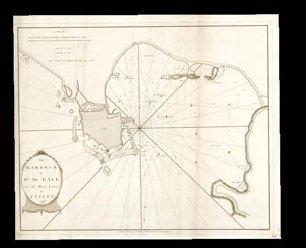
[ANONYMOUS]
The harbour of Pt.a de Gale, on the West Coast of Ceylon.
Publication London, Laurie and Whittle, 12th December 1798.
Description Engraved chart.
Dimensions 455 by 550mm (18 by 21.75 inches).
A chart of the Harbour of Galle in Sri Lanka, published by Laurie and Whittle in 1798.
The city had served as the island’s most important port since antiquity, and was further developed during the sixteenth century by Portuguese explorers, and then under Dutch colonial rule. When, in 1796, the British won Sri Lanka (“Ceylon”) from the Dutch, they adopted the fort at Galle as the administrative centre of the district.
This chart shows the fort (“city”) on the natural promontory that forms the bay, with a “water place” and “sandy beach” identified on the opposite shore. The majority of the details, however, are hydrographic, with soundings, stations, obstacles and anchorages represented, as well as dashed lines showing “ships track in” and “ships track out”.
A century later, marine traffic would be diverted to Colombo Harbour following the construction of breakwaters there by the British authorities. Nonetheless, Galle remained Sri Lanka’s principle harbour for most of the nineteenth century.
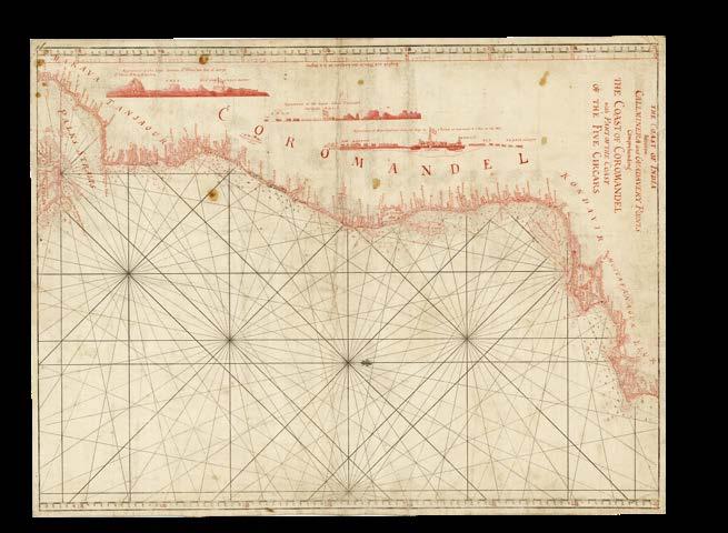
[ANONYMOUS]
The coast of India between Callminera and Guadavery Points comprehending the Coast of Coromandel with part of the coast of the Five Circars.
Publication [London, c.1778].
Description Original working manuscript chart on two joined sheets, pen and black and red ink over engraved latitude scale and rhumb lines, “Coast of Coromandel” inscribed to verso.
Dimensions 460 by 615mm (18 by 24.25 inches).
The Coromandel Coast
A manuscript chart of the southeastern coast of India, known as the Coromandel Coast, over which the European colonial powers were in constant competition throughout the seventeenth and eighteenth centuries.
The coast was home to Portuguese, Dutch, French, British, and Danish settlements, with the British ultimately gaining control of the region in the eighteenth century. The area shown on this chart would later be officially designated the Godovari District of the Madras Province, governed from Fort St. George. The French, who briefly took the capital from 1746 to 1749, retained Pondicherry (“Pondichery to the French”) and Karaikal (“Karikal to the French”) until 1954. The town of Nagapattinam is identified on the chart as “Negapatnam to the Dutch”, but just three years later it would be conquered by the EIC.
Recent colonial developments are reflected on the chart, which includes the five Circars, a 30,000 square metre stretch of coastline, which the Mughal emperor had granted Lord Robert Clive in 1764. Palk Strait, the stretch of water between India and northern Sri Lanka, is identified, named after Robert Palk, Governor of Madras from 1755 to 1763. In the surrounding waters, depth soundings and obstacles are given, against the background of printed rhumb lines and latitude scale, which has been amended by hand. On the left-hand side three views show the appearance “of the land between St. Thome and Fort St. George”, “about paliacata” and “of Masulipatnam from the bay”.
The first printed edition of the chart, identical to this manuscript, was included in Sayer and Bennett’s 1778 ‘Oriental Pilot’. A revised version was published by Sayer in 1789, and then by Laurie and Whittle in 1794, and was included in their 1797 ‘East-India Pilot, or Oriental Navigator’.
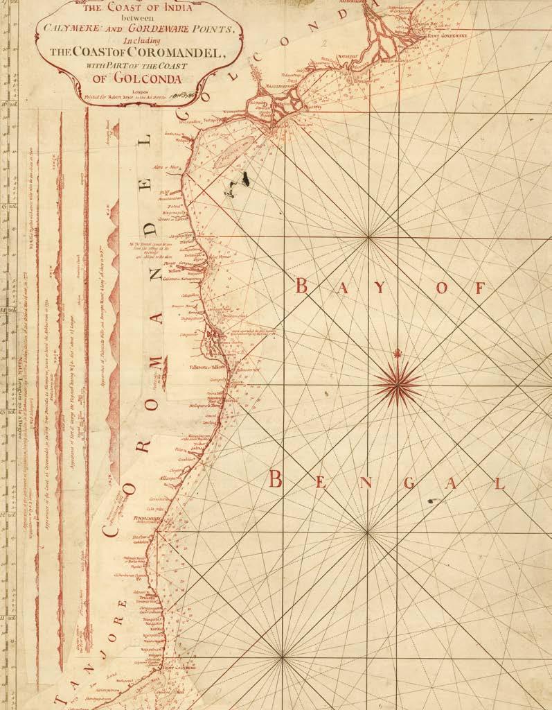
[ANONYMOUS]
The coast of India between Calymere and Gordeware Points, including the coast of Coromandel, with part of the coast of Golconda.
Publication London, Robert Sayer, 1st October 1786.
Description
Engraved chart with manuscript annotations in red ink, with extensive insets, “Coast of Coromandel” inscribed to verso.
Dimensions 610 by 460mm (24 by 18 inches).
The Coromandel Coast, updated
A printed chart of the Coromandel Coast, first published by Sayer and Bennett in 1778 (item 142), here updated by hand in preparation for publication by Sayer in 1786.
The title has been changed and is now housed in a cartouche, and the views of the land from the sea have been extended and one added. The whole coast has been redrawn on insets, with the names and locations of settlements heavily revised and additional maritime obstacles identified. Palk’s Strait between India and Sri Lanka has been populated with soundings.
The printed chart, re-engraved and updated with the manuscript revisions, appeared in Sayer’s ‘Oriental navigator’ of 1789, and was later republished by Laurie and Whittle in 1794.
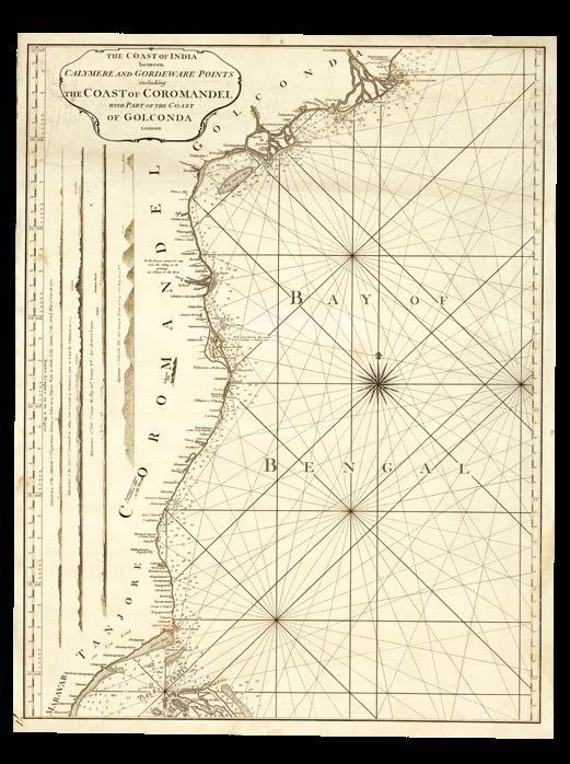
[ANONYMOUS]
The coast of India between Calymere and Gordeware Points, including the coast of Coromandel, with part of the coast of Golconda.
Publication London, [1794].
Description Engraved chart with manuscript annotation in red ink, “Hooghly River” inscribed to verso.
Dimensions 600 by 460mm (23.5 by 18 inches).
An update without an imprint
An early state of the chart of the Coromandel Coast, updated with the manuscript changes made to the 1778 edition (item 143). This example lacks an imprint, which would be added to the final version published by Laurie and Whittle in 1794.
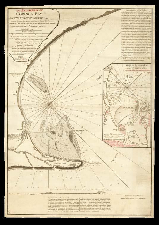
“Coringa Bay and River are capable of being made of infinite service to the King’s, Company’s, and Country ships”
LESLEY, Captain Charles
A plan of Coringa Bay on the coast of Golconda with the soundings laid down as taken on every point of the compass, by a coat from the center, being the place of the ship (the Orford man of way) Design’d and Executed by Cap.tn Charles Lesley.
Publication [London], 1774.
Description
Original working manuscript chart on two joined sheets, pen and black ink on paper, “Coringa Bay” inscribed to verso.
Dimensions 725 by 515mm (28.5 by 20.25 inches).
A manuscript chart showing Coringa Bay, today Korangi, at the centre of India’s long eastern coastline.
The chart extends from Uppada (“Uppara”) down the coast to the mouth of the Godavari (“Point Guadauery or Point Gordevare”), India’s second longest river. Within the bay, soundings are given and features such as sandbanks, breakers, and mud banks are identified. On the land appear two villages, mountains, and “remarkable trees” discussed further in a note at the bottom of the sheet. Besides this there are two views showings the “appearance of Point Gordevare by Captain Charles Lesley”.
The HMS ‘Orford’ sailed to the East Indies in March 1771 under the command of Sir John Strachan, who was replaced in command by Captain Lesley in October of the following year. Under Lesley, the ship sailed for three years before returning to Britain in 1775, where he died soon after.
In the “Observations” made by Lesley on this chart, he explains that “I have been under a necessity to put in Coringa Bay to refit His Majesty’s Ship the Orford, and stop several leaks”. He goes on to advise that “Coringa Bay and River are capable of being made of infinite service to the King’s, Company’s, and Country ships, being the only place on the west coast of the Bay of Bengal where a vessel above 200 tons can be refitted, or stop her leaks, during the S.W. Monsoon”.
The first printed edition of the chart was published by Laurie & Whittle in 1798 under the title ‘An Eye Sketch of Coringa Bay on the Coast of Golconda’, retaining all of Captain’s Lesley’s geographical information and notes.
Finding Hope (Island)
LESLEY, Captain Charles
An Eye Sketch of Coringa Bay on the Coast of Golconda, with the soundings laid down as taken on every point of the compass, by a boat from the center, being the place of the ship (the Orford man of war) designed and executed by Capt.n Charles Lesley.
Publication London, Laurie and Whittle, 12th August 1798.
Description Engraved chart with manuscript inscriptions in red ink, pencil annotation to verso.
Dimensions 715 by 495mm (28.25 by 19.5 inches).
An early, pre-publication state of Laurie and Whittle’s 1798 printed chart of Coringa Bay (item 145).
Red-ink annotations across the chart show where the makers wanted last minute edits to be made before the final version of the chart would be printed. A title cartouche has been added and the title itself changed from ‘A Plan of Coringa Bay...’ to ‘An Eye-Sketch of Coringa Bay...’. Some new topographical details have been added to the coast, and “Hope Island”, formed in the late-eighteenth century from the sediment carried by the Godavari, now appears. Most significantly, a large inset has been added on the right showing a ‘Plan of Corgina Bay from an actual survey made in 1789 by Michael Topping, the Company’s surveyor on the Madras Establishment’.
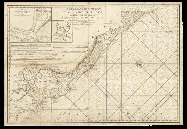
[ANONYMOUS]
A geohydrographic draught of the Northern Circars or maritime provinces on the coasts of Golconda and Orissa from all the original surveys extant of those parts.
Publication London, [c.1790].
Description
Original working manuscript chart on two joined sheets, pen and black and red ink on paper, “Northern Circars” inscribed to verso in black ink, minor soiling.
Dimensions 565 by 815mm (22.25 by 32 inches).
A fair copy manuscript chart, ready for engraving, showing the Northern Circars, an important stretch of land along the coast of the Bay of Bengal. Circar, the English spelling of the Mughal ‘sarkar’, refers to an administrative district of an Indian state, a term and system in place since the early-sixteenth century. The Northern Circars was a division of the Madras Presidency in British India, gained gradually from 1758 to 1823, which consisted of the northernmost and most important circars of the Presidency, totalling an area of 30,000 square miles. In 1765, Mughal Emperor Shah Alam II had granted these circars to Lord Robert Clive, also known as Clive of India, and three years later , at the Treaty of Masulipatnam, they were ceded to the British East India Company.
The chart shows the Northern Circars, outlined in red ink, from Chicacole in the north down to Guntur (“Guntoor”, now Murtuzanagar) further south. Lakes, routes, roads, rivers, settlements, and relief are all represented, and in the coastal waters soundings are provided. The title states that this information was gleaned from “all original surveys extant of those parts”, and a further note in red ink attributes those around Guntur to the surveying efforts of the ‘Neptune’, which made four voyages for the EIC in the 1780s.
Views of the land, as seen from the sea, are given in the upper left-hand corner of the chart, beneath two insets showing ‘A plan of the town and harbour of Vizagapatnam’ and ‘The fort of Bimilipatnam’. The former town would be won by the Company in 1802, and made the fort their main trading base on the east coast.
The first printed edition of chart would be published by Laurie and Whittle in 1794, under the same title.
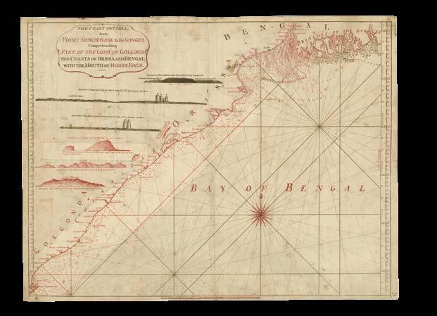
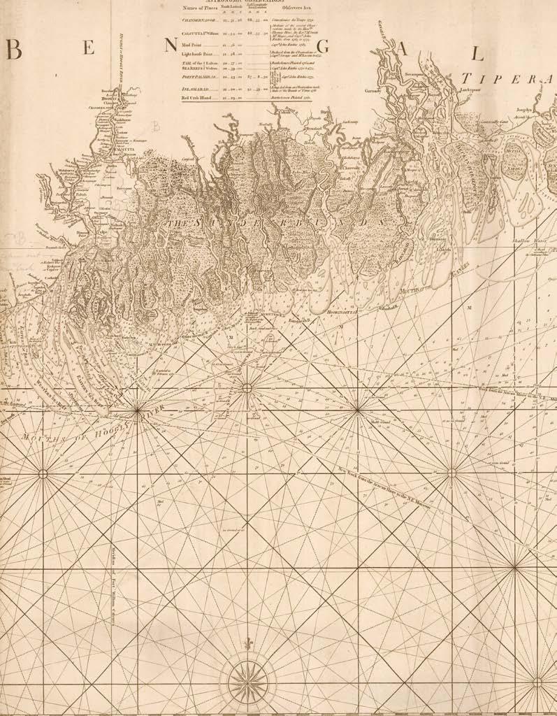
[ANONYMOUS]
The coast of India, from Point Gordeware to the Ganges comprehending part of the coast of Golconda, the coasts of Orissa and Bengal with the mouth of the Hughly River.
Publication London, Sayer and Bennett, April 1778.
Description
Engraved chart with extensive manuscript annotation in red ink, with two inset corrections, “Gordeware to the Ganges” inscribed to the verso.
Dimensions 465 by 615mm (18.25 by 24.25 inches).
From Gordeware to the Ganges
A printed chart of the Bay of Bengal, from the mouth of the Ganges in the Hooghly River down to Coringa Bay, originally published by Sayer and Bennett in 1778 and here much amended in preparation for a later edition. The title has been slightly changed, and is now housed in a cartouche. Three of the original views of the land have been retained and three new ones added. Almost the whole coastline has been redrawn, with soundings and topography updated, and details about maritime obstacles such as sand-banks improved according to recent hydrographic activity in the area, especially around the Hooghly River, which was of great importance to the British in providing access to Calcutta.
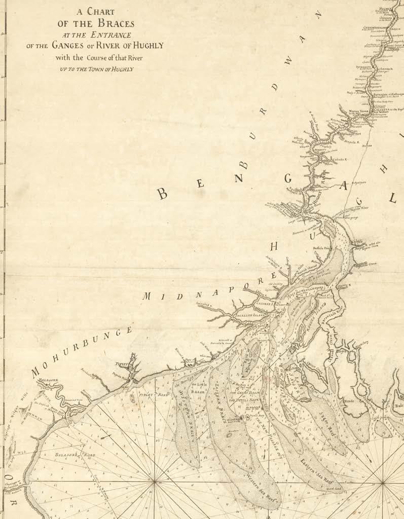
[ANONYMOUS]
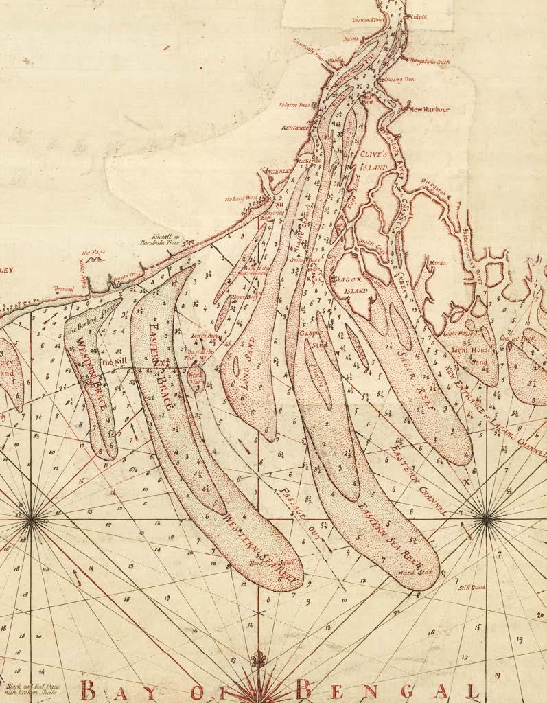
A chart of the braces at the entrance of the Ganges or River of Hughly with the course of that river up to the town of Hughly.
Publication [London, c.1778].
Description
Original working manuscript chart on two joined sheets, pen and black ink, two short manuscript notes in red ink, “The Braces” inscribed to verso, minor soiling and loss to margin.
Dimensions
620 by 465mm (24.5 by 18.25 inches).
The braces of the Bay of Bengal
A manuscript map of the mouth of the Ganges into the Bay of Bengal, as part of the Hooghly, the westernmost distributary of India’s largest river.
The map is heavily based on Jean-Baptiste Bourguignon D’Anville’s ‘Entrée du Gange’, which had been published in 1752. The same sand backs, offshoots, islands, and settlements are shown, with additional soundings included in the waters of both the river and the shallows of the bay. Mountains and some British possessions have been added. An overland route is shown, connecting the “town and fort [of] Hughly” (now Hughli-Chuchura) down to the town of “Culpee” (Kulpi), where the Hooghly River opens up into the small delta that empties into the Bay of Bengal.
There are no tracks of any voyages, but a manuscript note in red marks where the Duke of Albany was lost on the 26th July 1772, a date repeated in the lower margin. The EIC ship was run aground in the sand back of “the old passage out”, that is, the stream that runs to the east of Sagar Island, here “Isle Sagor” as the maker seems to have forgotten to translate D’Anville’s French!
The first printed version of the chart appeared in Sayer and Bennett’s ‘Oriental Navigator’ of 1778 under the same title, with the addition of “improved from Mr. D’Anville’s chart of the mouth and course of the Ganges”.
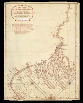
[ANONYMOUS]
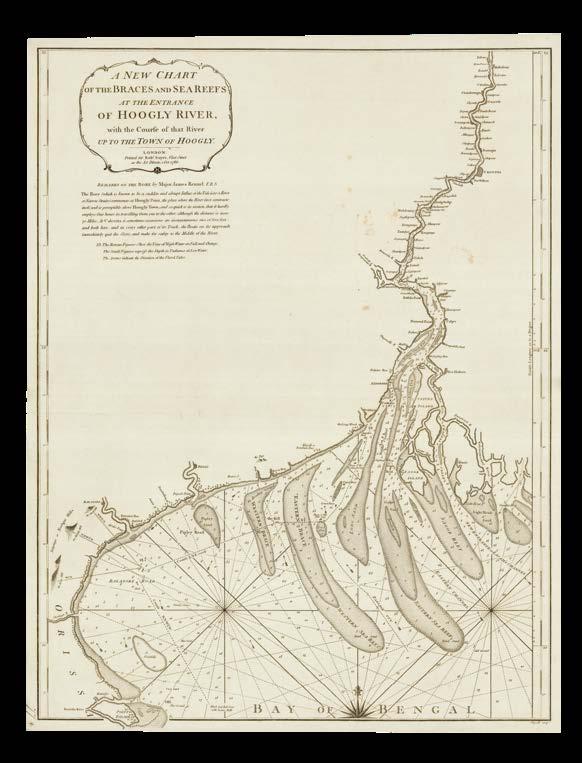
A new chart of the braces and sea reefs at the entrance of the Hoogly River, with the course of that river up to the town of Hoogly.
Publication [London, c.1783].
Description
Engraved chart with extensive manuscript annotations in red ink, with imprint excised and numerous pasted overslips, with “Drawing of Hoogly River” inscribed to verso.
Dimensions
610 by 460mm (24 by 18 inches).
A Hooghly updated chart
The map published in 1778 as ‘A chart of the braces at the entrance of the Ganges or River of Hughly’ has been amended and modified for re-publication in 1786 as ‘A new chart of the braces and sea reefs at the entrance of the Hoogly River’. The maker has made numerous changes to the upper part of the river and its opening on pasted overslips. The route between “Hoogly” and “Culpee” no longer appears and many toponyms have been changed: omitted, added, or with adapted spellings. Lacam’s failed dream of New Harbour (see item 153) appears just north of Rogue’s Island, now named “Clive’s Island”, as found on the surveys associated with the project and subsequent legal case. “Channel Creek” is alternatively identified as “Lacam’s Channel”. The sandbanks at the entrance of the Hooghly River have also been redrawn, and soundings have been updated.
The title has been in part erased and rewritten, the imprint excised, and the whole thing housed in a simple but ornate cartouche. Beneath this are “Remarks on the Bore by Major James Rennel F.R.S”, which describe the swift influx of the water into the straits that can occur, and upon which boats should “immediately quit the shore and make for safety to the middle of the river”. This chart was fully re-engraved for printing, and published in 1786 by Robert Sayer under the same title.
[ANONYMOUS]
A new chart of the braces and sea reefs at the entrance of the Hoogly River, with the course of that river up to the town of Hoogly.
Publication London, Rob[er]t Sayer, 1st October 1786.
Description Engraved chart.
Dimensions 600 by 460mm (23.5 by 18 inches).
Brace yourself
The stretch of the Ganges from the eponymous town of “Hoogly” down to its entrance into the Bay of Bengal is here presented as a printed chart. Engraver George Wigzell prepared a completely new plate for the chart, adopting all of the manuscript changes added to Sayer’s first map of the area. We have been unable to find any other examples of the 1786 chart published by Sayer, either held by institutions or on the market; examples of the 1794 version published by Laurie and Whittle are available.
“at X a buoy in wanting”
RITCHIE, J[ohn]
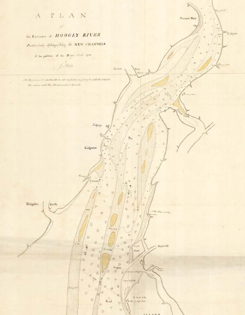
A plan of the entrance of the Hoogly River particularly distinguishing the New Channels and the position of the buoys.
Publication March, 1783.
Description Manuscript chart, pencil, red ink and yellow wash on tracing paper.
Dimensions 1420 by 760mm (56 by 30 inches).
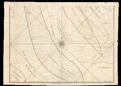
A fair copy of EIC hydrographer, John Ritchie’s survey of the entrance of the Hooghly River.
Precise soundings are given in the Eastern Channel, which is described as “all fine anchoring ground”, with small anchor symbols identifying the choicest options. Buoys are also represented in the river, although Ritchie warns that “at X a buoy in wanting”. The condition of the river bed is also described variously as “entirely new soft ground”, “hard sand”, and “fair sand mist with Ore of Iron”. Branching off from the main channel is Channel Creek, the site of Benjamin Lacam’s failed efforts to establish New Harbour.
[LACAM, Benjamin; and John RITCHIE]
Channel Creek.
Publication [London, c.1783].
Description
Original working manuscript chart on two sheets, pen and black and red ink on paper, “Channel Creek” inscribed to title cartouche, with extensive insets, some minor damage and loss.
Dimensions
Each sheet 530 by 735mm (20.75 by 29 inches).
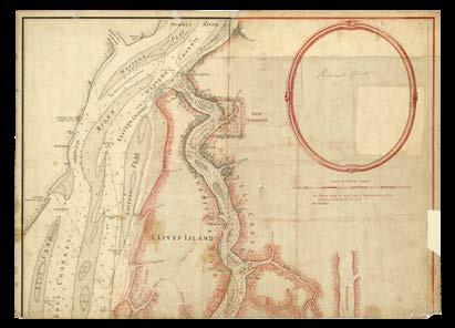
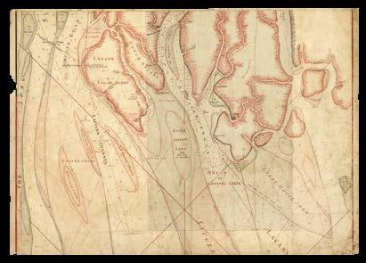
A magnificent manuscript chart of the Hooghly River drawn by Benjamin Lacam, whose dreams of a “New Harbour” on Channel Creek led to a court case that lasted almost three decades.
In 1760, draughtsman Lacam arrived in Calcutta and eventually found himself in the South Twenty Four Parganas region, famed for its fertile soils, nourished by the silt of the Ganga-Brahmaputra river system. For centuries this land had been reclaimed for cultivation through the clearing of mangrove forests, and the East India Company was keen to continue this work. The shipping trade in the Bengal Delta was expanding, and relied heavily on the anchorage at Kedgeree, which was slowly but surely silting up. Merchants were therefore looking for an alternative, and so when Lacam claimed to have found a “naturally forming harbour” in the tidal waters east of the “Baratulla River”, an offshoot of the Hooghly River also known as the Eastern Channel, the EIC granted him the right to develop the land
26 miles inland from the Bay of Bengal, “New Harbour” would be the closest harbour to Calcutta. Lacam funded the development himself, trusting that he would be reimbursed once boats and ships began docking in New Harbour and paying the associated tolls. In 1776, however, just two months before the construction was due to be completed, the EIC withdrew the land-grant, claiming that Lacam’s reports about the navigability of the water were unreliable. Financially ruined, Lacam filed a lawsuit in the Mayor’s Court at Calcutta, setting up a legal case that was not resolved for three decades. Despite the Company conceding in 1809 to raise Lacam’s pension from £600 to £1000, his dream of New Harbour was never realized.
The present chart was drawn by Lacam, making use of the work of EIC hydrographer John Ritchie, who surveyed the area in 1781 and 1783. It focuses on the stretch of the Hooghly near the river’s end, where it empties into the Bay of Bengal. New Harbour appears on the eastern bank of “Channel Creek” (also known as Baratulla or, as he suggests here “Lacam’s Channel or New Entrance”) with its docks, garden, and creek all pictorially represented. It is opposite the northern point of what is now Sagar Island (“Sauger or Sagor Island”), but which at this point was a collection of smaller islands, the northernmost of which Lacam labels “Clive’s Island”, a toponym which appears to have originated on his surveys. On Sagor details such as a “top of high trees which are very remarkable”, a “tank of fresh water” and “square buildings resorted to be the Gentoos”, are shown.
In the upper right-hand corner of the first sheet, a circular cartouche has been left blank, ready for the engraver to fill in with the chart’s title.
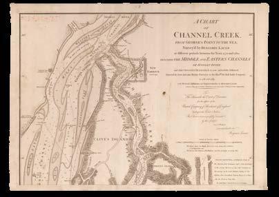
LACAM, Benjamin; and John RITCHIE
A chart of Channel Creek, from George’s Point to the sea, survey’d by Benjamin Lacam at different periods between the years 1770 and 1780; including the Middle and Eastern Channels of the Hoogly River and the crossing track which is now universally followed, survey’d by John Ritchie marine surveyor to the Hon[oura]ble the East India Company, in 1781 and 1783; with several additions and improvements by Benjamin Lacam.
Publication London, Laurie and Whittle, 1794, corrected to August 1808.
Description Engraved chart on three sheets, with minor manuscript amendments in pencil and red ink.
Dimensions
Each sheet 535 by 720mm (21 by 28.25 inches).
The third printed edition of Lacam’s map of Channel Creek, first published by Laurie and Whittle in 1794 and here updated to 1808, with a further manuscript note identifying a wreck from 1809.
The tracks of the 1807 and 1808 surveying expeditions of the HMS ‘Sceptre’ have been added to the chart (item 153), “obligingly communicated” by Alex Lumsdale, master of the ship. The tracks of the Charlton East Indiaman, from 1801, are also shown, accompanied by a note, and labelled illustrations show where other ships were wrecked in the area.
The chart has also been updated in manuscript in several places. On the upper sheet, the letter “A” marks where the wreck of the ‘Asia’ occurred in 1809, despite “fine weather”. The central sheet shows the anchorage of the HMS ‘Psyche’ in 1805 and the term “mizen” added to a shoal. On the lower sheet two soundings have been corrected, the anchorage of the HMS ‘St. Fiorenzo’ in 1805 added, and the description of the Eastern Channel as the route “by which all ships navigate out of the Ganges and all the large ships enter at all seasons” crossed out, with the note “to be taken out”. In fact, a new “course which a ship may safely take in a gale at West and obtain good anchorage under King’s Island” has been drawn in to the east.
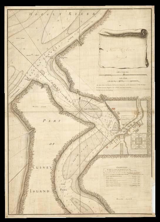
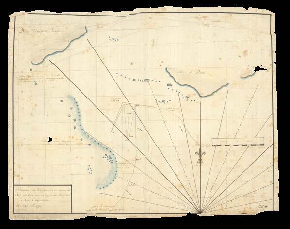
[LACAM, Benjamin]
New Harbour Bengal.
Publication [London, c.1784].
Description
Original working manuscript chart on two joined sheets, pen and black and red ink on paper, with extensive insets, “Lacam’sNew Harbour” inscribed to verso.
Dimensions 720 by 510mm (28.25 by 20 inches).
A manuscript large-scale chart showing the New Harbour project headed by Benjamin Lacam in the 1770s and 1780s.
Lacam’s New Harbour (item 153) is presented in great detail, with magazines, dockyards, carpenters, granaries, and a “bake house” shown along the banks of “Corelier Creek”, the waters of which are populated by seven illustrated ships. There is also a “tank of fresh water” surrounded by a “garden”, as well as a “park for deer and cattle” and a hospital.
A key above the plan of the harbour explains the colours used to represent the boundaries of New Harbour (green), brick buildings (red) and thatched wooden bungalows (yellow). Beneath, “observations” reference six separate hydrographical surveys of the area which were undertaken between 1775 and 1777. Despite the great hydrographical efforts Lacam went to, in order to prove the validity and promise of his project, the EIC ultimately withdrew funding and his dream of New Harbour was never realized.
This example is the office fair copy, ready to be engraved, although the title cartouche still awaits a full title and publisher’s imprint.
[LACAM, Benjamin]
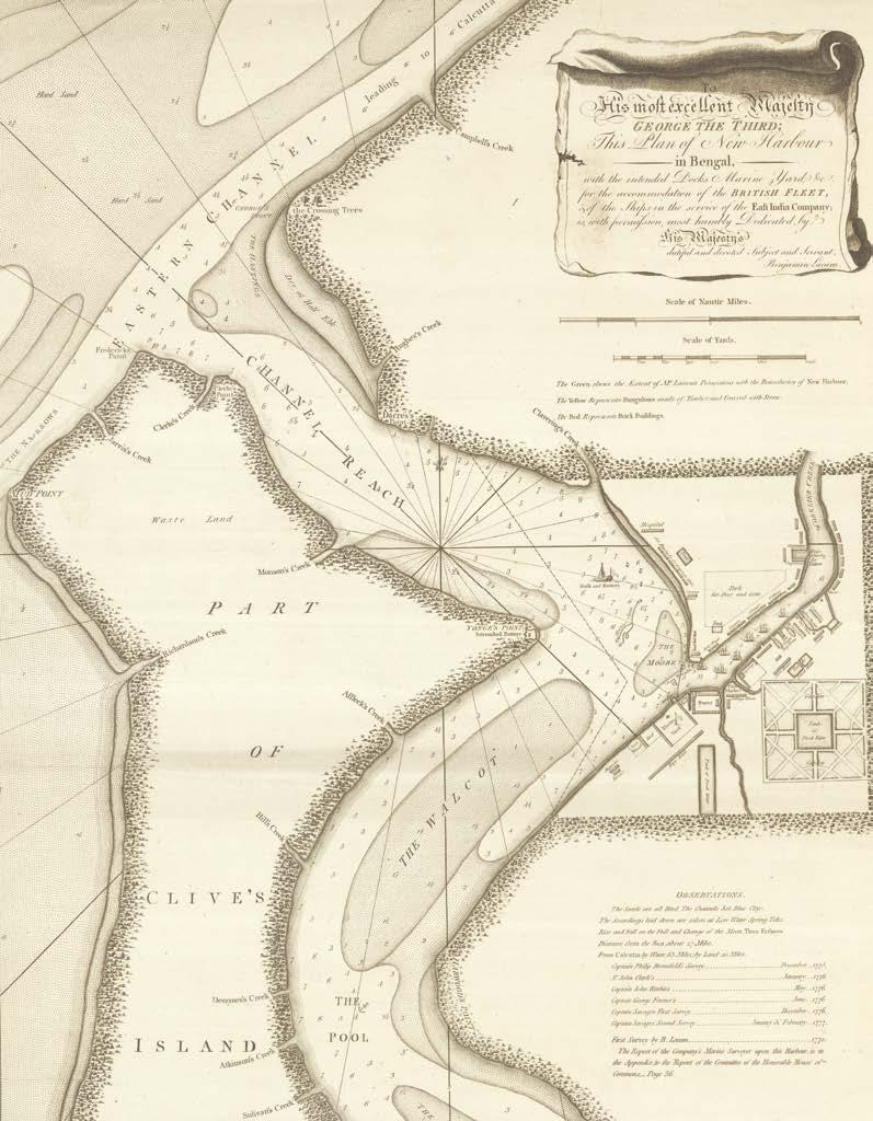
To His most excellent Majesty George the Third; this plan of New Harbour in Bengal, with the intended docks marine yard &c. for the accommodation of the British, & of the ships in the service of the East India Company, is, with permission, most humbly dedicated by His Majesty’s dutiful and devoted subject and servant, Benjamin Lacam.
Publication London, Laurie and Whittle, 12th May 1794, corrected to May 1803.
Description Engraved chart.
Dimensions
710 by 505mm (28 by 20 inches).
The incredible hulk and battery
The printed second edition of Lacam’s large-scale plan of New Harbour (item 155), with updates to 1803.
No new features have been added to the harbour itself, but in its waters there is now a “hulk and battery”. This refers to a decommissioned ship armed with artillery that provided the port with reliable defence. The sandbank previously drawn just north of the harbour has been removed and hydronyms given to identify the various creeks on “Clive’s Island”.
[LACAM, Benjamin; and John RITCHIE]
Lacam’s Original Drawings of New Harbour & Bengal.
Publication [London, c.1794].
Description
Original working manuscript chart on two sheets, pen and black and red ink, with square inset correction to lower sheet, on paper, “Lacam’s original drawings of New Harbour and Bengal” inscribed to verso, some minor loss.
Dimensions
Each sheet 540 by 725mm (21.25 by 28.5 inches).
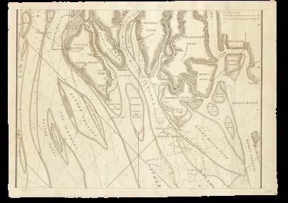
A magnificent manuscript chart of the Hooghly River drawn by Benjamin Lacam.
The chart extends from the town of “Hoogly or Hughly” down to the Bay of Bengal, with New Harbour on the eastern bank of “Channel Creek or Baratulla River”. On the upper sheet an inset shows the stretch of the Hooghly that passes Calcutta. “Fort William” dominates the city, but there are also smaller sites such as “the Armenian Church” and “the Bankhall” shown.
In the water are soundings, arrows, and shoals, while on the land settlements and specific buildings are identified. Soundings are a combination of those claimed by Lacam, those recorded by Commissioners in 1788 to review the reliability of his data, and those of EIC hydrographer John Ritchie. Navigational obstacles are identified with great precision, and wrecks including those of the ‘Caledonia’, lost in 1775, the ‘Verelst’, lost in 1776 and the ‘Snow Vizagapatnam’, lost in 1777, are illustrated on the treacherous reefs.
The map would first be published in print by Laurie and Whittle in 1794.
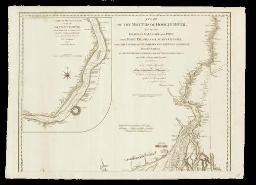
LACAM, Benjamin; and John RITCHIE
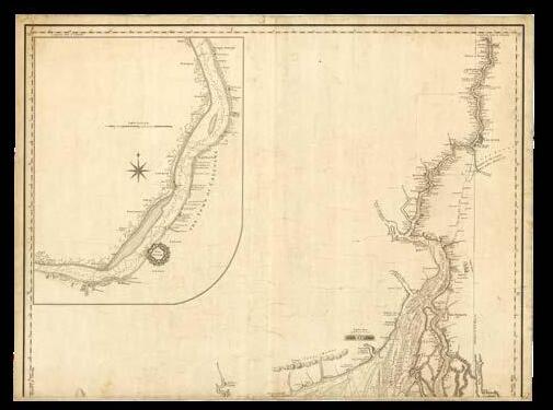
A chart of the mouths of the Hoogly River, and of the roads of Balasore and Piply, from Point Palmiras to Lacam’s Channel, with the course of that river up to the town of Hoogly from the surveys of John Ritchie, marine surveyor to the Hon[oura]ble the East India Company, and those of Benjamin Lacam.
Publication
London, Laurie and Whittle, 1794, corrected to August 1808.
Description
One engraved chart on two sheets, with minor manuscript markings in pencil and red ink.
Dimensions
Each sheet 545 by 720mm (21.5 by 28.25 inches).
The Hooghly River, updated to 1808
A detailed chart of the Hooghly River, the printed edition of Lacam’s original survey.
Lacam’s survey (item 157) had been engraved and printed in 1794 by Laurie and Whittle, and the present chart is the third edition, updated to 1808. A navigational note by Lacam is now found on the lower sheet. Titles have been added to both the main chart and the inset, as well as a key and a dedication from Lacam to “the Right Honourable, the Lords Commissioners of the Admiralty”. Even by 1808, Lacam’s legal battle was still not over; only the following year would it be resolved, with the EIC agreeing to increase Lacam’s pension and grant £600 to his wife upon his death.
[LACAM, Benjamin; and John RITCHIE]
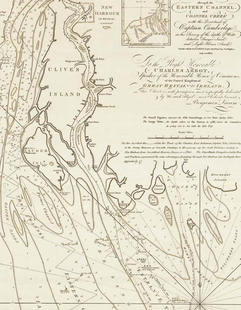
Navigation through the Eastern Channel and Channel Creek with the Boat-track of Captain Cumberlege, in his survey of the depths of water between Sauger Sand and Light House Sand, together with the track of H.M.S. Sceptre of 74 Guns, Capt. Jos. Bingham, in the year 1807.
Publication
London, Rob[er]t Laurie and Ja[me]s Whittle, 14th August 1808.
Description Engraved chart.
Dimensions 680 by 460mm (26.75 by 18 inches).
References Bhattacharyya D., ‘Empire and Ecology in the Bengal Delta: The Making of Calcutta’, 2018, pp.45-76.
A single-sheet version of the chart of Channel Creek published by Laurie and Whittle in August 1808, now updated.
Though the one-sheet chart has fewer topographic details due to scale, there is a new, small inset showing “Lacam’s track to cross sea-reefs, now finally adopted”. Moreover, it has been updated from the manuscript annotations made to the three-sheet chart (item 154). The anchorages of HMS ‘Psyche’ and HMS ‘St. Fiorenzo’, and the new route through the Eastern Channel, which were added in red ink, are now part of the printed chart, demonstrating the swiftness with which the firm operated. The term “mizen”, however, seems to have been forgotten once again, as it has again been inscribed in red.
[LACAM, Benjamin; Bartholomew PLAISTED; John RITCHIE; Captain George FARMER; and Captain Augustus SAVAGE]
Lacam’s Bay of Bengal.
Publication [London, c.1808].
Description
Original working manuscript chart, pen and black and red ink, with one inset correction, “Lacam’s Bay of Bengal” inscribed to verso.
Dimensions 630 by 940mm (24.75 by 37 inches).
Bengal, Bangladesh, and Burma
A manuscript chart, prepared for its third edition, spanning what are now three independent countries.
Drawing on the surveying work done in different regions by Benjamin Lacam (Hooghly River), John Ritchie (Bay of Bengal), Bartholomew Plaisted (Indian coast), George Farmer (Ramree Island and the coast of Bangladesh), and Augustus Savage (Indian coast), the chart extends from Cuttack (“Cattack or Kutteck”) in the state of Odisha across the Bay of Bengal, encompassing the southern coast of Bangladesh, to the Rakhine coast of Myanmar to Ramree Island (“Broken Islands”). Lacam has again drawn on the hydrographic work of John Ritchie of the East India Company. Soundings, maritime obstacles, winds, tides, and topographical features on the land are given in great detail. The inner part of the Hooghly delta has been redrawn in red ink on an inset.
Ten buoys are identified by name via an alphabetical key. On the left-hand side of the cart four vertically-oriented views show the appearance of parts of the eastern shore from the water. In the upper centre, a table of astronomical observations list those made by sailors from 1761 to 1779, including those “deduced from the observations of the Capt.n Savage, and Mr Lacam in 1775”. The upper right-hand corner of the chart contains an inset of “Chittigong River Surveyed by Bartho[lomew] Plaisted in 1761”. The city of Chittigong, or Islamabad as it was known in the Mughal era, is situated along the banks of the the Karnaphuli River, a name it has held for centuries but which is not included on the chart.
LACAM, Benjamin; Bartholomew PLAISTED; John RITCHIE; Captain George FARMER; and Captain Augustus SAVAGE
A chart of the northern part of the Bay of Bengal, between Point Palmiras and the Aracan shore, from the surveys made by Bartholomew Plaisted and John Ritchie, surveyors to the Hon[oura]ble the East India Company, compared with those of Captain George Farmer, Captain Augustus Savage, and Benjamin Lacam: as also with the nautical observations of the Captain John Hicks.
Publication
London, Laurie and Whittle, 12th August 1808.
Description Engraved chart on three joined sheets, with pencil annotations.
Dimensions 625 by 925mm (24.5 by 36.5 inches).
The printed third edition of the chart of the Bay of Bengal. Despite incorporating all the information drawn on the manuscript chart (item 160), there are still edits to be made, as shown by annotations in pencil. These list three points: “1. XX taken out. 2. XX. 3. XX”, with a line leading to the Eastern Channel in the Hooghly River, on the banks of which Benjamin Lacam had attempted to build a new harbour. The annotation is accompanied by the initial B and a swirled line, a mark which also appears on two other charts (item 158 and 154). Since both of those are also focused on the Hooghly River, it seems likely that the annotations were made by Benjamin Lacam himself.
HAYTER, Captain [George]; [after] Jean-Baptiste D’APRÈS DE MANNEVILLETTE
A chart of the coast of Pegu with the adjacent coasts of Arakan and Tanasserim from a drawing communicated by Captain Hayter, with several additions from Mr d’Après de Mannevillette.
Publication [London, c.1778].
Description
Original working manuscript chart on two joined sheets, pen and black ink on paper, “Coast of Pegu” inscribed to verso, minor soiling and loss.
Dimensions 815 by 590mm (32 by 23.25 inches).
A manuscript chart, ready to be engraved, showing Pegu, now Bago, in southern Burma, now Myanmar.
An independent kingdom from the thirteenth to sixteenth century, Pegu was conquered by the Portuguese and, despite attempts to restore its autonomy, was then taken over by the Bamar dynasty, from another Burmese ethnic group, and finally annexed by the British in 1852. The present chart shows Pegu at an interesting time: it was drawn by Captain George Hayter when he was serving as First Mate aboard the ‘Worcester’ East Indiaman from 1756 to 1757, the year in which the Bamar king, Alaungpaya captured the city of Pegu and established his reign there.
Naturally, the chart focuses more on navigation than politics. Soundings and obstacles appear around the coast and in the rivers, and there are notes about ground conditions, currents, and floods. There are three inset plans of the Arakan River further north, Perseen River, and the Sirian River, the latter of which would become a key point of conflict in the Anglo-Burmese Wars of the nineteenth century. In the lower left-hand corner of the map the northern point of Great Andaman Island appears, along with the Cocoas Islands.
The first printed edition of the chart is found in Sayer and Bennett’s ‘Oriental Pilot’.
CHARLES Capt [George] Hayter
A chart of the coast of Pegu with the adjacent coasts of Arakan and Tanasserim from a drawing communicated by Captain Hayter, with several additions & improvements from the NeptuneOriental, Capt. John Ritchie, Capt. Charles Newland, and others.
Publication London, Laurie and Whittle, 12th September 1798.
Description Engraved chart.
Dimensions 805 by 580mm (31.75 by 22.75 inches).
A later edition of Captain George Hayter’s chart of Pegu (item 162), published by Laurie and Whittle in 1798.
Three new views of potentially perilous islands are drawn vertically beside the inset plans, to which has also been added a ‘Plan of Martaban River’, which would be captured by the British in the First Anglo-Burmese War of 1824-1826, and officially annexed as part of British Lower Burma in 1852. New soundings have been added along the coast of Arakan, now the Rakhine State of Myanmar.
[DODWELL, Captain]
A chart of Andaman and Nicobar Islands with the adjacent islands in the Bay of Bengal from a drawing communicated.
Publication [London, c.1778].
Description
Original working manuscript chart on 2 joined sheets, pen and black ink, with additional strip pasted, on paper.
Dimensions 355 by 735mm (14 by 29 inches).
A manuscript chart showing the Andaman and Nicobar Islands, with a later pasted slip.
The chart would be published in 1778 by Sayer and Bennett under the same title but with the name of the maker supplied: Mr. Dodwell. This may have been George Dodwell, Captain of the ‘Patty’, who led a number of expeditions in southeast Asia. Oriented to the east, the chart shows the two main clusters of islands: the northern Andaman and the southern Nicobar. Soundings and maritime obstacles are scarce, but the maker has identified “Sombrero Channel [as] very safe and clear” while Great Andaman’s “Inner Channel [is] exceedingly dangerous”.
The anchorage and part of the track of the 1763 voyage of the ‘Boscawen’ are identified, as well as that of “the Pondicherry French East Indiaman”. There is also a pasted sheet which shows the islands on a smaller scale, and appears to have been cut from a later manuscript chart. It is not clear why this slip would have been pasted on to an earlier preparatory state of a chart.
HUNT, Captain Phineas; Captain MACKAY; [and] Captain John RITCHIE
A new chart of the Andaman and Nicobar Islands, with the adjacent islands from the draughts and observations of Capt[ain] Phineas Hunt, Capt[ain] Mackay, Capt[ain] John Ritchie and other navigators.
Publication London, Sayer and Bennett, 14th August 1783 [amended to 1784].
Description
Engraved chart on two joined sheets, with manuscript annotations in red ink, “Andaman & Nicobar Islands” inscribed to verso.
Dimensions
355 by 730mm (14 by 28.75 inches).
Additions to the Andamans
The 1783 printed edition of Sayer and Bennett’s chart of the Andaman and Nicobar Islands had already been heavily amended from the 1778 edition, and has here been edited even further by hand, ready to be republished with updates the following year.
The various islands of the two chains appear with greater detail and precision, and many of their coastlines have been redrawn to make additional corrections, particularly those of Great Adaman and the Cocos Islands. East Andaman has been added, with the water separating it from the larger island named “Diligent’s Straits”.
The channel between Great and Little Andaman has been labelled “Duncan’s Passage” and a new inset shows “the channel between the Great
and Little Andaman Islands through which the Ganges, Capt. Duncan, passed in his voyage to and return from Manilla in August 1759 and January 1760”.
Numerous soundings have been added, as well as two new views of Narcondam and Great Andaman. Interestingly, there are no manuscript changes to the Nicobar cluster. In the upper left-hand corner of the chart is a further inset showing ‘the Harbour of Carmorta’. Remarks by Captain Phineas Hunt concerning the Nicobar Islands are to be found in the lower right-hand corner.
[ANONYMOUS]
No. part of the Great Andamans Island.
Publication [c.1795].
Description Original working manuscript chart, ink black and red ink and pencil on tissue paper.
Dimensions 700 by 495mm (27.5 by 19.5 inches).
Great Andaman
The surveyor’s fair copy of a chart showing the northern part of Great Andaman Island, as well as the smaller isles that surround it.
Soundings are given around the coast and in Port Cornwallis, named after Admiral William Cornwallis, best friend to Lord Nelson and commander-in-chief of the Channel Fleet during the Napoleonic Wars. In the early 1790s the British authorities relocated a penal colony to Port Cornwallis, but after less than five years it was abolished due to the prevalence of disease there.
The surveyor suggests “a good track to make and bound Landfall Island during the S.W. Monsoon and to avoid Ranger, Jackson’s and Union Ledges, it will be the safest mode to stand quite across the Bank till out of soundings”. A grid and longitude and latitude scales have been drawn in pencil.
A new chart of the Andaman and Nicobar Islands, with the adjacent islands from the draughts and observations of Capt[ain] Phineas Hunt, Capt[ain] Mackay, Capt[ain] John Ritchie and Lieut[enan]t McCluer, &c.
Publication London, Laurie and Whittle, 12th July 1797 [amended to 1798].
Description Engraved chart on two joined sheets, with manuscript annotations in red ink.
Dimensions 350 by 720mm (13.75 by 28.25 inches).
Andaman again
An example of the 1797 edition of Laurie and Whittle’s ‘Andaman and Nicobar Islands’, chart, amended with manuscript updates in preparation for the 1798 edition.
Three new views, two of Narcondam and one of Barren Island, have been added, as well as three additional insets. In the lower left-hand corner is one of Port Cornwallis on “Isle Chatham”, while the two in the upper right are smaller in scale but much more detailed, providing soundings and
maritime obstacles around the coast of Great Andaman. The title has also been extended to acknowledge the contribution of Lieutenant McCluer. The insets are printed, but that of Narcondam has two profiles added in red ink, while a profile of Barren Island, just to the right of ‘The Saddle on Great Andaman’ has also been added in red ink manuscript.
A new chart of the Andaman and Nicobar Islands, with the adjacent islands from the draughts and observations of Capt[ain] Phineas Hunt, Capt[ain] Mackay, Capt[ain] John Ritchie and Lieut[enan]t McCluer, &c.
Publication
London, Laurie and Whittle, 12th July 1799 [amended to 1809].
Description Engraved chart on two joined sheets, with manuscript annotations in red ink.
Dimensions 355 by 725mm (14 by 28.5 inches).
Lawrie by Laurie
Laurie and Whittle’s 1799 ‘Andaman and Nicobar Islands’ chart, updated by hand with information up to 1809.
The manuscript amendments made to the chart are focused on the island of Great Andaman, specifically the west coast, which has been almost completely redrawn. The two most significant recent expeditions to the Andaman Islands had been a surveying voyage undertaken by Lieutenant J.S. Paterson in 1804 and 1805, and in 1809, an effort to establish a permanent presence led by Major James H. Lawrie. It may be the soundings recorded on the former expedition that are added here in red ink, while the impetus for an update to the chart may have come as a result of the latter.
Blow the Man Down
Traditional English
OCEANS
ALTEA GALLERY & DANIEL CROUCH RARE BOOKS
China Sea
Of the giant Cinnamologus bird Herodotus writes: “Where the wood grows, and what country produces it, they cannot tell—only some, following probability, relate that it comes from the country in which Bacchus was brought up. Great birds, they say, bring the sticks which we Greeks, taking the word from the Phoenicians, call cinnamon, and carry them up into the air to make their nests” (3.111.2). The world’s obsession with such exotic and elusive spices grew throughout antiquity and into the medieval period, giving rise to some of the first truly international trade routes as European powers strove to discover and then dominate the route to the Moluccas, or the ‘Spice Islands’.
Even though the early Dutch and English voyages to the Spice Islands had used the Sunda Strait to access the Indonesian archipelago, the most proven route to the Moluccas was via the Malacca and Singapore Straits, held by the Portuguese from 1511 to 1641, when it came under Dutch rule. Imagine the surprise and delight of the English in 1795, when, as the result of an extraordinary turn of events including the French Revolution, the exiled ruler of the Netherlands, Prince William of Orange, offered his English custodians control of all Dutch colonies, to prevent them too from falling into the hands of the French. The EIC immediately occupied Malacca. Java followed in 1811, with Thomas Stamford Raffles appointed Lieutenant-Governor of the colony.
In 1818, Raffles persuaded the EIC to establish a base at Singapore, the strategic location of which one Captain Alexander Hamilton had identified in 1703: “a proper place for a company to settle a colony on, lying in the center of trade, and being accommodated with good rivers and safe harbours, so conveniently situated that all winds served shipping both to go out and come into those rivers”. British control of this strategic location helped to establish their supreme dominance of the China trade during the 1820s. It was soon settled by Europeans and Chinese, and became a financial centre, as well as an international shipping hub. In 1824, the British signed an agreement with the Dutch, which carved up Southeast Asia between them: Britain held the mainland, and the Dutch the islands. British law had given the EIC a monopoly on the China trade, however, by 1833 that had been completely undermined by independent entrepreneurs.
This history is told in the series of charts presented here, mostly in manuscript, which demonstrate the constant shifts, new discoveries and changing priorities of the European powers in the waters of the China Sea.
[JEFFERYS, Thomas, after]
A chart of the straits of Malacca and Sincapore.
Publication [London, 1778].
Description Original working manuscript chart, pen and black ink, on three joined sheets of paper, with insets.
Dimensions 630 by 850mm (24.75 by 33.5 inches).
Jefferys’s chart of the Malacca Strait
A magnificent manuscript chart of the Straits of Malacca, one of the most important stretches of water for international trade during the colonial era.
Even though the early Dutch and English voyages to the Spice Islands had used the Sunda Strait to access the Indonesian archipelago, the most proven route to the Moluccas was via the Malacca and Singapore Straits, held by the Portuguese from 1511 to 1641, when it came under Dutch rule. It would still be nearly 200 years before the English turned their attention in earnest to gaining the strategic advantage of presentday Singapore at the eastern entrance to the Straits.
The present chart by Thomas Jefferys, was posthumously published around the time that the East India Company charged Captain Francis Light with the responsibility of setting up a trading post in the Malay Peninsula, although it was not until 1791 that the Union Flag was raised for the first time in Penang (“Queda”). Britain’s continuing interest in the region is demonstrated by the detailed and precise charts made and continually updated during the late-eighteenth and early-nineteenth century.
The entirety of modern-day Malaysia is shown, with the southern part of Thailand (“Kingdom of Siam”) and the northern half of Sumatra. Rather than the tracks of any specific ships, two dashed lines show the “old passage disused” and the “new passage” between the Indian Ocean and the Indonesian archipelago. The lines extend from the Andaman Sea to the north and meet at the opening of the Malacca Strait. From there they continue onwards, weaving through the Strait’s reefs, banks, islands and rocks, with soundings given along the whole route. To the south they past eastwards through the “Straits of Sincapore”, which run to the south of Singapore Island. The “Old Straits” (now the Johor Strait) are shown to the north; Johor is marked as being at the mouth of the river “Ihor or Johor”.
The upper right-hand quarter of the chart is covered in useful views of the land, as seen from the waters of the straits, helping pilots to locate their current position. A key beneath the title offers translations of Malayan terms: “pulo” is explained to mean “island”, “tanjong” “point” and “songi” “river”. In the lower right-hand corner of the chart ‘a plan of the Road of Achen with the several passages between the adjacent islands’ has been pasted over the “directions for sailing thro the Straits of Malacca and Sincapore”. It shows the northern tip of Sumatra at Banda Aceh (“Achen”), with the “Bengal passage”, “Malacca passage”, “Sedre or Cedar passage”, “Surat passage” and “old course towards the straits of Malacca” represented as dashed lines.
The chart would be published in Sayer and Bennett’s ‘Oriental pilot’ of 1778, and then republished numerous times with updates and revisions.
EVANS, Lieutenant Thomas
A survey of Prince of Wales’s Island or Pulo Penang from the south end of Praya Sand to the Bountings Islands, showing the North and South Channels with the soundings, rocks, shoals &c. &c. taken in the year 1805 by Lieut[enan]t Tho[ma]s Evans of H.M.S. Russel.
Publication [London], 1805.
Description
Original working manuscript chart on two joined sheets, pen and black ink, with grey wash, on paper with extensive insets.
Dimensions 895 by 520mm (35.25 by 20.5 inches).
A manuscript chart showing Penang Island, which the British had renamed Prince of Wales Island, in 1786, in the Strait of Malacca, and the stretch of water that separates it from the “Coast of Queda”, that is, the mainland.
In the waters, soundings, sands, and smaller islands are identified. On the Prince of Wales Island is a plan of George Town, Britain’s first colonial possession in Southeast Asia. Roads such as “Queen Street” and “Love Lane” are labelled, and the “Governor’s House” and “Hospital” identified. Outside the main town, there are “barracks”, a “slaughter house”, the “Company’s garden”, a “waterfall”, and, simply, “Scotland”. Roads connect this settlement to the peak of a 1880-foot hill, from which it is implied astronomical observations were taken, and down to a small group of buildings on the south coast of the island. A view of a hill is given, matched by two other such illustrations on the opposite shore; an inset box on the right has been left blank for a ‘View of Fort Cornwallis taken from the northward’.
Laurie and Whittle have dedicated the chart “to Sir Edward Pellew Bar[one]t, Rear Admiral of the Red”. In 1804, Rear Admiral Pellew was appointed Commander-in-Chief of the East Indies, with his headquarters in Penang.
[ANONYMOUS]
A Plan of the Straits of Colong.
Publication [London, c.800].
Description Original working manuscript chart, pen and black ink on paper.
Dimensions 470 by 595mm (18.5 by 23.5 inches).
The Big Klang
A manuscript chart showing the “Straits of Colong”, now the Klang Strait on the western coast of the Malaysia Peninsular.
Soundings are concentrated around Port Klang, although the port is not named, and scarce elsewhere; there is minimal warning about maritime obstacles such as “breakers”. An inset in the lower left-hand corner offers a slightly larger-scale plan of the bar with soundings. Along the left-hand side of the chart are ‘Directions for the Straights of Colong’, which instruct sailors about shallow waters, “recommend to keep a boat ahead” to identify those points which “you may round as near as you please”.
The maker of the plan is not identified, but he may have been a crew member aboard one of the ships that sailed the waters of the Klang Strait in the 1790s, aiming to suppress Dutch and French influence in the region.
[ANONYMOUS; after Thomas JEFFERYS]
The straits of Sincapore with those of Durion, Sabon and Mandol.
Publication [London, 1778].
Description
Original working manuscript chart on two joined sheets, pen and black ink on paper, with “Sincapore” inscribed to verso.
Dimensions 460 by 620mm (18 by 24.5 inches).
A Bute-iful chart of the Malacca Strait
An early and magnificent manuscript map of the Malacca Strait, ready to be engraved.
As one of the most important connections in the global shipping route, safe navigation through the Malacca Strait, and eventually wider control of the region, became an increasing priority for the British during the eighteenth and nineteenth centuries. This chart shows little topographic information on the land, but the waters are described with shallow ground, anchorages, and soundings provided.
The rack of the East Indiaman ‘Bute’, which sailed through the region in 1765 under Captain Patrick Maitland, is shown leading down through the Straits of Durion, while another general track shows the route to “Pulo Aore”, now Aur Island. The chart is drawn after Thomas Jefferys, whose ‘Chart of the Straits of Malacca and Sincapore’ was also published in ‘The Oriental Pilot’, in which the present chart appeared in 1778. It would be regularly updated throughout the following decades as new first-hand observations were made by ships in the area.
LINDSEY, Captain J[ohn]
The south part of the Straits of Malacca, inscribed to Capt[ai]n G.G. Richardson by Captai]n J. Lindsey.
Publication London, Laurie and Whittle, October 1798.
Description Original working manuscript chart on two joined sheets, pen and black ink and pencil on paper, staining.
Dimensions 485 by 740mm (19 by 29.25 inches).
Captain Lindsey’s Malacca Strait
A chart of the straits of Malacca and Singapore (“Sincapour”), ready to be engraved.
From 1769 to 1772, Captain Lindsey was commander-in-chief of the East Indies Station, during which time he produced this chart. Soundings are given throughout the Strait, although many of the more treacherous maritime hazards such as rocks and sandbanks are not shown with great precision or consistency. The northern coast of Sumatra is not depicted in detail, but along the coast of the Malay Peninsula, Lindsey has identified mountains and rivers.
A note beneath the title cartouche states that he made use of “the French manuscript draught of that Straits in the possession of Captain Richardson”. Features of the map have been crossed-out in pencil, likely where the engraver was ensuring that he had added all the details to the copper-plate. The printed chart was published by Laurie and Whittle on November 1st, 1798.
[ANONYMOUS]
[Strait of Malacca].
Publication [London, c.1802].
Description
Original working manuscript chart, pen and black ink, on two sheets, each of two sheets joined with one inset.
Dimensions
Sheet one: 940 by 600mm (37 by 23.6 inches; sheet two: 940 by 630mm (37 by 24.8 inches).
A new survey of the Straits of Singapore from Pulo Pesang to Bintang Hill with the soundings, rocks, and shoals, taken in the year 1804, by Lieutenant Thomas Evans of the HMS ‘Russel’, with some additions from other authorities.
The lower half of the left sheet is taken up with a larger-scale chart of North Sand off the Straits of Colong along the main strait. On the right sheet ‘The Straits of Sincapore on a larger scale’ are presented. The British had an active naval presence in these waters for decades before Sir Thomas Raffles famously established the station at Singapore in 1819.
The printed map would be published in 1802, with the title added. Let’s get this
BLACK, Alexander; John REDFORD; Captain HORSBURGH; G.G. Richardson; [and] John LINSDAY
Laurie & Whittle’s new chart of the Straits of Malacca, drawn from several surveys and manuscript charts of Alex[ande]r Black, the late Mr John Redford of the Nonsuch together with those of the Capt[ai]n Horsburgh, G.G. Richardson, John Lindsay &c. &c.
Publication London, Laurie and Whittle, 10th Feburary 1802.
Description Engraved chart, one of two sheets.
Dimensions 935 by 640mm (36.75 by 25.25 inches).
Malacca, 1802
The printed eastern sheet of Laurie and Whittle’s chart of the Malacca Strait (item 174).
From Pulo Pesang to Bintang Hill
EVANS,
Lieutenant Thomas
A new survey of the Straits of Sincapore from Pulo Pesang to Bintang Hill with the soundings, rocks, shoals &c taken in the year 1804, by Lieut[enant] Tho[ma]s Evans of the H.M.S. Russel with some additions from other authorities.
Publication [London], 1804.
Description
Original working manuscript chart on three joined sheets, pen and black ink, with grey wash, on paper, with “drawing of Sincapore by Lieut. Evans” inscribed to verso.
Dimensions 555 by 935mm (21.75 by 36.75 inches).
A manuscript map of the Straits of Singapore (“Sincapore”) from Pisang Island (“Pulo Pesang”) to the Riau Islands at Batam and Bintan Islands (“Bintang”).
In 1803, Thomas Evans joined Captain Robert Williams of the HMS ‘Russel’, which travelled through the East Indies throughout the following three years, as part of the British effort to ensure the security of trade through the strait and, naturally, to counter French expansion in the region. The track of the ‘Russel’ entering and leaving the Singapore Strait is shown, accompanied by soundings.
NICHELSON, [Captain] William
A plan of the bay on the south west side of Pulo Timon surveyed by Will[ia]m Nichelson 1763.
Publication 1763.
Description
Original working manuscript chart on two joined sheets, pen and black ink on paper, “Pulo Timon” inscribed to verso.
Dimensions 485 by 590mm (19 by 23.25 inches).
An interesting chart-cum-view of the southwest coast of the Malaysian island of Tioman (“Pulo Timon”).
In addition to the chart of the coast, which extends from “the north-west point of the bay which is also the N.W. point of the island” down to “the south-east point of the bay which is also the S.E. point of the island”, passing a number of points that include “Bluff Point” and “Asses Ears Point”, there is a view of the “appearance of the land as you lye at anchor in the bay in 18 fathom water”. A note besides the view describes how the island boasts a waterfall “which shines and looks like gold dust”. Soundings are given in the bay, and there are further sailing directions on the left-hand side.
The chart was made by Captain William Nichelson of the ‘Elizabeth’ during his voyage to the East Indies between 1758 and 1764. It was first published in Sayer and Bennett’s ‘Oriental pilot’ of 1778, and later in Laurie and Whittle’s ‘East-India pilot’ without any changes.
NICHELSON, William
A plan of the bay on the south west side of Pulo Auore surveyed by Will[ia]m Nichelson 1763.
Publication [London], 1763 [but c.1778].
Description
Original working manuscript chart on 2 sheets joined, pen and black ink on paper, “Pulo Auore” inscribed to verso.
Dimensions 465 by 580mm (18.25 by 22.75 inches).
A chart of Aur Island (“Pulo Auore”) off the east coast of the Johor state of Malaysia.
Similar to Nichelson’s chart of Tioman (item 177), hydrography is combined with an illustrated view to produce an interesting cartographical depiction of the island’s southwest coast. The mountainous coastal landscape is shown as a view, as it would appear to a ship anchored in the harbour. In the waters, soundings are provided, alongside symbols and letters that identify various sites, explained in the key above.
In addition to “sandy bays where the inhabitants have their houses, and where there are groves of coca-nut trees”, there are four labelled anchors which show “where the ships of the English squadron did lay in January 1763”, namely the ‘Elizabeth’, of which Nichelson was the captain, the ‘Weymouth’, the ‘Admiral Stevens’ and the sloop ‘Manilla’. There are also “remarks” about the land and its “inhabitants who are shy”, and sailing directions for entering and leaving the bay. In 1804, the Battle of Pulo Aura would result in a British victory over the French, demonstrating the importance of this region to European relations, especially during the Napoleonic Wars.
The printed chart first appeared in Sayer and Bennett’s 1778 ‘Oriental pilot’ and was republished by Laurie and Whittle in 1794 with no changes.
D’APRÈS
[DE MANNEVILLETTE, Jean-Baptiste, after]
A new chart containing the southwest part of the China Sea comprised between the Malaya Peninsula, Straits of Sincapore & the Straits of Banca, Gaspar and Billiton, and the Isle of Borneo from the Neptune Oriental of Mons[ieu]r d’Après with many additions and emendations.
Publication
London, Robert Sayer, [c.1782].
Description Engraved chart, with manuscript annotations, pen and black and red ink, on extensive insets, with extensions.
Dimensions 440 by 630mm (17.25 by 24.75 inches).
The China Sea
A heavily edited and updated chart of the southwest China Sea, with most of the chart redrawn.
Extending from the Malacca Strait across the China Sea to the western coast of Borneo, the extensive manuscript annotations and amendments reflect the increasing importance of the area to British interests. The chart is originally based on that of D’Après de Mannevillette, but has been updated with recent information.
New tracks have been added to those that originally appeared, including the tracks of the French ships ‘Chameau’ and ‘Elephant’ (1758), ‘Mascarin’ (1773), ‘Onslow’ (1775), ‘Vansittart’ and ‘Fleet’ (1781). Soundings and maritime obstacles are also presented in greater detail and precision, particularly in the important waters of the Malacca Strait. The islands of “Banca” (Bangka) and “Billiton” have been entirely redrawn. Along the left- and right-hand sides, 11 views have been added to show how certain stretches of land or islands appear from the sea.
The updated chart would be published in 1794 by Laurie and Whittle in their ‘East India Pilot’. Interestingly, the manuscript toponyms and soundings written here in red ink have generally been crossed out in pencil; it is likely that this reflects where the engraver marked out the ones that he had done as he undertook the engraving of the chart from this manuscript onto the copperplate.
[LLOYD, Captain, possibly]
Part of Banca / Part of Sumatra.
Publication [London, c.1796].
Description
Original working manuscript chart on two joined sheets, pen and black ink on paper.
Dimensions 650 by 745mm (25.5 by 29.25 inches).
The northern Bangka Strait
A draft of the northern part of the Bangka Strait which separates eastern Sumatra from the island of Bangka (“Banca”).
The chart includes the island’s northern shore with the distinctive Klabat Bay (“Clabat Bay”). Soundings, toponyms, and some anchorages are given around the northern coast, and along the passage through the east side of the Strait sailed by the HMS ‘General Elliot’. As item 181, this may have been an early draft for part of the chart of the Bangka Strait later completed by Captain Lloyd of the same ship (see item 182).
[LLOYD, Captain, possibly]
[Chart of the Bangka Strait].
Publication [London, c.1796].
Description
Original working manuscript chart on two joined sheets, pen and black and red ink on paper.
Dimensions 630 by 530mm (24.75 by 20.75 inches).
Take that to the Bangka
A large-scale chart of the Bangka Strait which separates eastern Sumatra from the island of Bangka (“Banca”).
The strait proved to be of importance during the Napoleonic Wars when the British and French were vying for power over Java. Ports are identified along two shorelines, and in the water soundings are given, provided by the voyages of the ‘General Eliott’ and the ‘General Medows’ to Batavia.
This may have been an early draft for part of the chart of the Bangka Strait later completed by Captain Lloyd of the same ship (see item 182).
[LLOYD, Captain]
Plan of the Straits of Banca, surveyed by Capt[ai]n Lloyd of the General Elliot country ship, and Mr. Bampton in his passage from China to Batavia and from Batavia to Malaca.
Publication London, Laurie and Whittle, Jan[uar]y 1st 1796.
Description
Partially-engraved chart on one sheet, with manuscript annotations in red ink.
Dimensions
475 by 335mm (18.75 by 13.25 inches).
The tracks of the ‘General Elliot’
A highly-detailed chart of the Bangka Strait (“Straits of Banca”) with the maker’s revisions and amendments in red ink.
The chart is an extension of the far more simple chart of the strait showing the tracks of the ‘General Elliott’ (item 181), with almost the entire island of Bangka (“Banca”) now shown, as well as more of the eastern coast of Sumatra. The ‘General Elliot’ under Captain Lloyd sailed through the strait in October 1789, where it saved the ‘Vansittart’, another East India Company ship which had struck a rock. The captain of the ‘Vansittart’, Captain Wilson, had undertaken a survey of the waters while stranded there, and it is likely that the present chart draws on his findings.
Topographical information on the land includes rivers, mountains, settlements, and ports along the coasts, and a view of “Monopin Hill” (Bukit Menumbing) is given in Sumatra. The northern and eastern coasts of Bangka have been redrawn fully in red, as has part of the Sumatran shore.
Extensive soundings are provided in the waters of the strait, as well as representations of shoals and sandbanks. The tracks of the ‘General Elliot’ and the ‘General Medows’ are again given, as well as another unnamed track which would be identified on the printed edition of the chart as that of the ‘Canton’, captained by Abel Vyvyan. Captain Vyvyan sailed through the strait in 1796. A longitude scale has been added along the lower margin of the chart in red ink, and the title and imprinted completed. All these manuscript updates would be incorporat onto the engraved plate for addition to the final printed chart.
[LLOYD, Captain]
Plan of the Straits of Banca, surveyed by Capt[ai]n Lloyd of the General Elliot country ship, and Mr. Bampton in his passage from China to Batavia and from Batavia to Malaca.
Publication London, Laurie and Whittle, Jan[uar]y 1st 1796.
Description
Engraved chart on two joined sheets, with manuscript annotations in red ink, with insets to margins, “N.11” inscribed to verso.
Dimensions 490 by 350mm (19.25 by 13.75 inches).
A chart of the Bangka Strait updated with the manuscript additions made on the preparatory version (item 182).
The updates to the coasts of Bangka and Sumatra have been incorporated, and all the new soundings, islands, and ships’ tracks added. Nonetheless, there are still edits to be made, as shown by the reappearance of the red-ink hand here, which provides yet more additions and corrections. These include rectifying spelling mistakes where the engraver misinterpreted the maker’s handwriting, adding in occasional missed soundings and removing others, and identifying the third set of tracks as those of Captain Vyvyan’s ‘Canton’. Indeed, a large note insists that “the date of Capt[ai]n Vyvian’s [sic] track and where to must be inserted”.
Interestingly, there do not appear to be any printed editions of the chart that include the few additions and corrections made here in red.
[JEFFERYS, Thomas]
A chart of the Straits of Sunda and Banca.
Publication [London, c.1778].
Description Original working manuscript chart on two joined sheets, pen and black ink on paper, “Streights of Mallacca [excised] Sunda & Banka” inscribed to verso.
Dimensions 645 by 870mm (25.5 by 34.25 inches).
Sunda, Bangka, and Gaspar
A manuscript chart of southern Sumatra, western Java, and the surrounding waters, which consist of the Sunda Strait, the Bangka Strait, and the Gaspar Strait.
No soundings are found in the waters of the Indian Ocean to the southwest, which contain the islands of South Pagai (“Isle of Nassau”), North Pagai (“Berglandt”) and Sipora (“Mantabey or Isle of Good Fortune”), except around the coasts of Sumatra and Java. By contrast, the straits are described with soundings, maritime hazards, and anchorages. Interestingly, the Gaspar Strait which runs between the islands of Bangka and Belitung (“Billiton”) is not named, although the western passage is labelled “Macclesfield Passage” after the voyage made by that ship in 1702.
On the land, information is restricted to the coasts, where the important port of “Batavia formerly Iacatra” (now Jakarta) is written in majuscules, and a note in southeastern Sumatra explains that “all the coast of this part of Sumatra is very low and no higher than the trees which cover it”. On the left-hand side of the chart are coastal views to help sailors determine their location.
The printed chart would be published in Sayer and Bennett’s ‘Oriental pilot’ in 1778, with the addition of an inset chart focusing on the Sunda Strait.
[VOC, after]
A chart of the Straits of Sunda from the manuscript draught of the Dutch East India Company.
Publication [London, c.1778].
Description
Original working manuscript chart on 2 sheets, pen and black ink on paper, “Strait of Sunda” inscribed to verso.
Dimensions 630 by 990mm (24.75 by 39 inches).
A manuscript chart of the Sunda Strait between Sumatra and Java, based on a Dutch chart.
Maritime hazards and soundings are identified, particularly along the coasts, and sources of fresh water noted. Although there are no tracks of any ships shown, it is possible to deduce the most common routes through the anchorages and soundings given; for example, the densely packed soundings around Java’s “Mew Island” indicate that the small strait between island and mainland offered safe passage, a fact confirmed by contemporary sailing directions.
In the lower right-hand corner of the chart is an inset showing ‘Zutphen or Hounds Islands off the east side of Hogs Point inlarged’. The southern point of Sumatra, now known as Tanhung Tua (“Tanjong Taca”) is shown to have a perilous set of obstacles including rocks, coral and “loose sand”, but also a “new spring of fresh water” and the promisinglynamed “Coconut I[sland]”.
The first printed edition of the chart appeared in Sayer and Bennett’s ‘Oriental pilot’ of 1778. An updated version was published in 1794 by Laurie and Whittle, with new information gathered on three British voyages: that of Captain Henry Smedley of the ‘Raymond’ in 1785, Captain Parker of the ‘Bridgewater’ in 1787, and Captain John Hall of the ‘Worcester’ in 1788.
[ANONYMOUS]
Rat Island on the west coast of the island Sumatra.
Publication [London, c.1778].
Description Original working manuscript chart, pen and black ink on paper.
Dimensions 460 by 570mm (18 by 22.5 inches).
Rat Island
A manuscript plan of Tikus Island, which was translated into English as “Rat Island”, so-named because of the shape of its rocks as seen from the sea.The reefs that surround the island are identified, and soundings given in the waters. In stormy weather, Rat Island offered shelter, and the route to it through the reef is presented here as a dashed, then dotted, line.
The printed plan of Rat Island would first be published in 1778 by Sayer and Bennett to accompany the chart of western Sumatra by Captain Joseph Huddart; it later appeared in various editions by Laurie and Whittle too. The final printed versions do not include the vignette of the island’s village that appears here.
[DUNN, Samuel, after]
A particular chart of the Sunda Strait.
Publication [London, c.1785].
Description Original working manuscript chart, pen and black ink on paper.
Dimensions 280 by 325mm (11 by 12.75 inches).
The Sunda Strait
A manuscript chart of the Strait between Java and Sumatra, which was of great importance during the eighteenth century as it offered passage between the valuable Spice Islands and the wider Indian Ocean.
Soundings, obstacles, and anchorages are provided, particularly around the coastal areas, and the island of Krakatoa (“Pulo Cractoa or Cracata I[sland]”) is shown before a massive volcanic eruption in 1883 transformed it. The volcano itself is clearly illustrated at the south of the island. Along the lower edge, views show how the strait would appear upon entrance from the south, and also the appearance of western Java from the water.
The chart is based on one of the region by Samuel Dunn, which may itself have used the same Dutch sources as Sayer and Bennett’s 1778 chart (item 191). The earlier map did not extend so far south as the present chart.
Manuscript mischief
D’APRÈS DE MANNEVILLETTE,
[Jean-Baptiste, after]
A chart of the Straits of Sunda from Point Winerow to North Island by Mons[ieu]r d’Après de Mannevillette in his Neptune Oriental.
Publication London, Robert Sayer, [c.1785].
Description
Original working manuscript chart on two joined sheets, pen and black and red ink on paper, with insets, indecipherable inscription to verso.
Dimensions 665 by 580mm (26.25 by 22.75 inches).
A chart of the Sunda Strait after French hydrographer D’Après de Mannevillette, showing southern Sumatra and much of the northwestern coast of Java.
Soundings and other maritime information are concentrated around the coastal waters, especially in the strait between the two major islands. Although the English East India Company had established a permanent trading post at Bantam as early as 1603, Dutch preference for Batavia as a trade hub, meant that the town soon faded into obscurity, and here is marked out merely by a square symbolizing the factory.
Remarks and revisions are made in red ink, to be incorporated into the final chart by the engraver. In the lower left-hand corner is a ‘Plan of Mew Bay or Canty Bay on the western coast of Java’ with remarks by Captain Carteret of the ‘Swallow’ which anchored there in 1768. Along the right-hand margin there are also two coastal views showing the land from sea, one depicting the “appearance of the southernmost part of Java by Captain Joseph Huddart”. The printed chart with all such additions would be published in 1794 by Laurie and Whittle.
Along with an indecipherable inscription to the verso, there is another charming addition: a paw print. Robert Sayer himself seems to have been something of a dog-lover, purchasing ‘The Spanish Pointer’ by George Stubb, sold at Sotheby’s in December 2024 for £1,800,000, for his personal collection in 1773. Whether this particular mark was made by his own pet, or another dog who managed to get up to mischief with the manuscripts, is not known, but it certainly creates an entertaining picture of workshop antics.
Straits of Bali
[after] D’APRÈS DE MANNEVILLETTE, Jean-Baptiste
A new plan of the straits situated to the East of Java and Madura commonly called the Straits of Bali and of Pondi and Respondi drawn from the observations and remarks of the English ships, the Winchelsea, commanded by the learned Mr. Howe, from whose surveys the plan of the eastern part of Madura, and the straits has been delineated: the Chesterfield in 1760; the Royal George in 1766. And of the French ships l’Eléphant and le Chameau in 1759: agreeable also to the remarks made there by the English ships, Onslow, Triton, Sandwich, Osterley in 1758; Tavistock and Hawke in 1759. By Mr. D’Après de Mannevillette.
Publication [London, c.1778].
Description Engraved chart with manuscript annotations in red ink, on multiple insets, on two joined sheets of paper, with minor loss.
Dimensions 510 by 345mm (20 by 13.5 inches).
A chart of the Bali Strait, which separates the island from the eastern coast of Java, with manuscript additions and updates.
Information on shore is scarce, but in the water soundings are provided along the coasts and on the routes taken by those ships from which the information has been drawn. There is also an inset chart showing the “Bay of Ballambouang” (now Pangpang Bay) as surveyed in 1766 by the ‘Royal George’. The three views of the land drawn on insets above this plan do not seem to have been included on any printed edition of the chart. Interestingly, information has been sourced from both English and French voyages, as described in the chart’s long title. Offering passage from the Indian Ocean to the lucrative East Indies, the Strait of Bali was one of the routes frequented more and more by colonial ships during the late-eighteenth and early-nineteenth centuries. The contribution of both English and French surveys here, indicates the increasingly collaborative nature of hydrography at this time, which was soon to be interrupted, at least between these nations, by the Napoleonic Wars.
The chart, based on the earlier work of D’Après de Mannevillette, was published in Sayer and Bennett’s 1778 ‘Oriental pilot’ with the manuscript emendations added here incorporated, and was republished by Laurie and Whittle in 1794 with no changes.
[ANONYMOUS]
A new chart of the Eastern Straits or the Straits to the east of Java with the adjacent islands.
Publication
London, Robert Sayer, [c.1785].
Description
Original working manuscript chart on two joined sheets, pen and black ink on paper, “Eastern Straits Engraved by Downes in 1792” inscribed to verso.
Dimensions
635 by 920mm (25 by 36.25 inches).
The Eastern Straits
An elegant and large-scale chart of the straits surrounding part of the Indonesian archipelago from the eastern coast of Java and Bali (“Baly or Bally”) to Timor.
Towns and settlements are identified along the coasts of the various larger islands, and soundings provided in the waters that separate them. The tracks of numerous ships are shown across the chart, including the ‘Warwick’ and ‘Pocock’ (1761), ‘Lord Holland’ (1780), ‘Hastings’, ‘Earl of Mansfield’, and ‘Lord North’ (1781).
The famous voyages of the HMS ‘Roebuck’ under William Dampier to New Guinea in 1699, and the ‘Endeavour’ under Captain Cook to New Zealand from 1768 to 1771, also appear, demonstrating the importance of the region for international exploration and eventually trade. Along the lower edge of the chart a number of views describe the “appearances of the principal straits”.
The imprint bears Robert Sayer’s name without that of Bennett, demonstrating that the chart must have been drawn after the latter’s name was officially dropped in 1785. The chart would be published in pilots by Laurie and Whittle, with updates and additions.
[ANONYMOUS]
A new chart of the Banda Sea including the isles of Amboyna and Banda, those of Bouro, Ceram and the circumjacent islands, with the N.E. end of Timor, and the isles to the eastward and northeastward of it.
Publication London, Laurie and Whittle, June 1799.
Description
Original working manuscript chart on two joined sheets, pen and black ink on paper, minor loss.
Dimensions 475 by 655mm (18.75 by 25.75 inches).
A chart of the Indonesian Banda Sea, one of the most highly-prized possessions of the colonial era thanks to its “Spice Islands”, rich in exotic and valuable spices, such as nutmeg and cloves.
Soundings are mainly concentrated around the large northern island of Seram (“Ceram”), where the British had allied with Nuku, Sultan of Tidore, to take back the island from the Dutch at the end of the eighteenth century. The only ships’ tracks to appear are those of the ‘Thames’ and the ‘Henry Addington’, which ran aground in British waters in 1799; the wrecks of a few others are also shown. In the upper corners are insets showing ‘the sound or bay of Amboyna’ and the ‘isles of Neira, Banda, and Goonong Api’. Ambon (“Amboyna”) was captured by the British under Admiral Peter Rainier in 1796, but would be restored to the Dutch as part of the Peace of Amiens in 1802.
The printed chart was included in Laurie and Whittle’s 1799 ‘EastIndia pilot’, on a single sheet with a larger-scale chart of the Banda, Goonong-Appee, and Banda-Neira islands.
[LARKINS, John Pascal]
A new chart of the Straits of Macassar between the islands of Borneo and Celebes with th[e] adjacent seas.
Publication London, Robert Sayer, 1791.
Description
Original working manuscript chart, pen and black ink on paper, “Maccassar Straits Feb.y 1791” inscribed to verso.
Dimensions 925 by 630mm (36.5 by 24.75 inches).
A manuscript chart of the Makassar Strait (“Straits of Macassar”) which runs between Borneo and Sulawesi (“Celebes”), on both of which the Portuguese, Dutch, and British all had factories.
The number of ships’ tracks that appear on the chart, each presented with the soundings and other observations they recorded, is testament to the importance of these waters to the colonial powers. The voyages of the ‘Pocock’, ‘Vansittart’, ‘Oxford’, ‘Warick’, ‘Diana’, ‘Hastings’, ‘Union’, ‘Jason’, and ‘Bridgewater’ throughout the 1760s, 1770s, and 1780s are evidenced by extensive tracks and notes. The Dutch presence is also acknowledged, although their attempts to settle the island of Balambangan, shown here with a great amount of information in the surrounding waters, were beginning to prove futile at the time this chart was made.
Settlements, towns, rivers, and harbours are identified along the coasts of Borneo, Sulawesi and some of the other islands shown partially or entirely. There are also numerous views illustrating the lay of the land, as seen from the Strait.
The chart was made by John Pascal Larkins, who was stationed in Bengal and made several other charts of the southeast Asian seas. Although Robert Sayer’s name appears on the imprint, the first printed edition of the chart was published in 1794 by Laurie and Whittle, with some additions including a note about “Tanakeka Island”.
[ANONYMOUS]
A chart of the passages between the Philippine and the isles of Borneo and Mindanao and of those to the southward of the Solo Archipelago and the Isle of Mindanao.
Publication [London, c.1794].
Description Original working manuscript chart on two joined sheets, pen and black and red ink on paper, with extensive insets, indecipherable inscription to verso.
Dimensions 625 by 930mm (24.5 by 36.5 inches).
A magnificent manuscript chart of the southern China Sea, Sulu Basin (“Sooloo Sea”) and Celebes Sea, with parts of Borneo, the southwest Philippines and the islands of the Sulu Archipelago.
Much information is provided on the land, particularly around the coasts of the islands, where, in addition to the names of ports, rivers, towns, and cities, details are given such as “inhabited by the Oran Idaan called also Maroots”, “the South Mountain where they get plenty of gold”, and “the Kalagan Mountains of a stupendous height”. The waters are described in even greater detail. In addition to soundings, obstacles, and anchorages, the tracks of numerous voyages are shown. Among them are those of the ‘Pocock’ (1761), ‘Royal Captain’ (1762), ‘Carteret’ (1767), the ‘Jason’ (1771), ‘Northumberland’ (1783), the ‘Ganges’ (1784), ‘York’ (1786), and ‘Warren Hastings’ (1787). Famous historic expeditions are also referenced: “These are the two islands seen by Dampier in 1686”. Additional descriptive notes identify, for instance, “where the Sooloo people fish for pearls” or peaks “which in clear weather can be seen 18 leagues off”.
Along the right-hand side of the chart, three insets give larger-scale representations of ‘the Harbour of Silla in Mindanao’ and the ‘appearance of Canaquin Island’ by John Watson of the ‘Royal Captain’, and ‘the Bay of Sooloo on board the Pocock January 1761’. Updates and revisions to the chart appear in red pen, including the redrawing of part of the coast of Borneo, North Sulawesi, and almost all of the Palawan (“or Paragua”) Archipelago. New additions include an inset showing coastal views, the smoking volcano of Karangetang (“the Peak of Siao”), and short notes identifying, for example, the “Isles of St. Johannes in the Old Spanish Maps, very dangerous”. The printed chart would be published with all these updates incorporated in 1794 by Laurie and Whittle.
CARR, Captain Robert
A chart of the China Sea and Philippine Islands with the archipelagos of Felicia and Soloo, shewing the whole tract comprized between Canton and Balambanga with the soundings, shoals, richs &ca. composed from an original drawing communicated by Capt[ain] Robert Carr and compared with the map of Pedro Murillo de Velarde engraved at Manilla 1734, as well as with the surveys of several British navigators.
Publication [London, c.1778].
Description
Original working manuscript chart on two joined sheets, pen and black ink on paper, “China Sea & Philippine Islands” inscribed to verso.
Dimensions
795 by 630mm (31.25 by 24.75 inches).
One of the finest eighteenth-century charts of the Philippines
The manuscript for one of the finest eighteenth-century charts of the Philippines.
The highly-detailed chart draws its copious information from numerous sources, including a draft by Captain Robert Carr, the 1734 map of the great Jesuit cartographer Pedro Murillo de Velarde, and later hydrographers, such as d’Après de Mannevillette, who is credited here for the location of “a rock” south of Taiwan (“Tayouan”). Likewise, as well as more recent voyages, such as that of the ‘Royal Captain’ in 1773, the tracks of important historic voyages including “Magellan’s Track in 1521” and “Dampier’s anchoring ground August 6th 1687” are shown. Naturally, attention is drawn to the site of a British victory, where “the Spanish Galeon, Nostra Señora de Cabadonga taken by the Centurion June the 20 1743”.
Maritime hazards and soundings are provided, especially around the coasts of the various islands, and small notes give both warnings (“rocks above water according to the first Dutch charts”) and suggestions (“Straits of St. Juanico for small vessels”). Along the right-hand side of the chart, insets of ‘The Ports of Ylocos on the west coast of Luzon’ and ‘The Bay of Subic on the west coast of Luzon’ show larger-scale depictions of these important anchorages.
The first printed edition of the map was published in Sayer and Bennett’s 1778 ‘Oriental pilot’.
[ANONYMOUS]
Plan of Solsogon Harbour on the south east coast of Luconia from Murillo.
Publication [London, 1775].
Description Original working manuscript chart, pen and black ink on paper, clipped to corners.
Dimensions 240 by 260mm (9.5 by 10.25 inches).
Solsogon Harbour
A chart of Sorsogon Harbour, which would be published in Laurie and Whittle’s 1794 ‘East-India pilot’ on a single sheet with another showing Bongo Bay.
“Solsogon Harbour” (Sorsogon), on the Bicol Peninsula of Luzon, the Philippines’ largest island, was of strategic importance to the British in the late-eighteenth and early-nineteenth centuries, with its natural harbour offering safe anchorage for ships. Although the Philippines were under Spanish rule, the British took a particular interest in the region due to its important location between the South China Sea and the Pacific Ocean.
The chart presents little information about the land, with only a few settlements identified, while in the sea major sandbanks are represented, and soundings given within the bay.
HAYTER, Captain [George]
A general chart of the China Sea drawn from the journals of the European navigators, particularly from those collected by Capt[ain] Hayter, ascertained by astronomical observations.
Publication [London, c.1787].
Description
Original working manuscript chart on two joined sheets, pen and black ink on paper, “China Sea” inscribed to verso, minor damage and losses to margins.
Dimensions 850 by 630mm (33.5 by 24.75 inches).
The Great Shoal of China
An important small-scale yet detailed map of the China Sea, extending from the southern coast of China, “Cochinchina”, now in Vietnam, and Cambodia, with part of Malaysia including “Sincapore”, across to Borneo and the islands to its north, including Luzon (“Luzon vulgo Luconia”) and Palawan (“Paragua or Palawan”). Along the coasts of China, Cambodia, Malaysia, and Northern Borneo, soundings and obstacles are given, but in places less thoroughly-explored by the British, including Luzon, these are much more limited. Indeed, in some places it is acknowledged that there is “very little known”.
The “track of the Royal Captain towards Balambangan in December 1773” is shown setting off from “Canton” (now Guangzhou), landing at “the Negroes Heads, Scarborough Shoal or False Marsingola” where the ‘Scarborough’ had landed on September 12th, 1748, and terminating at “Royal Captain’s Shoal, December 17th 1773”. The ‘Royal Captain’ had been carrying merchandise from China as well as several passengers when it struck the shoal; although the vessel was seriously damaged, no lives were lost and the crew was able to repair it before sailing on to Malaysia. A line off the coast of Binh Thuan (“Bin-thoan or Tsiompa”) is labelled “Scorpion’s Tail”, which likely refers to some maritime phenomenon such as an unusual current or hidden reef.
The printed map would have an additional table of astronomical observations, as well as the publishers’ imprint.
[HAYTER, Captain George]
A new chart of the China Sea with its several entrances drawn from a great number of draughts, journals and other nautical documents, regulated by astronomical observations.
Publication London, Laurie and Whittle, 12th May 1802.
Description Engraved chart with manuscript additions in pencil, on two joined sheets of paper.
Dimensions 945 by 625mm (37.25 by 24.5 inches).
Pushing
An 1802 edition of Captain George Hayter’s chart of the China Sea, with manuscript updates in pencil.
The printed edition of Hayter’s chart (item 196) had already been extended southwards to show the whole of Borneo and part of Sumatra and “Celebes” (Sulawesi), with a great deal of nautical information added to the surrounding waters. These include soundings, obstacles, and the tracks of ships such as the ‘Jason’, the ‘Pitt’, the ‘Bridgewater’, and the ‘York’. Extensive information has been added to the waters north of Borneo, especially around the island of “Balambangan”, where the Dutch were trying, ultimately without success, to establish a base during the 1780s and 1790s.
There are also new insets showing ‘the islands and coasts between St. Johns and the Great Landrone’ and ‘a sketch of Northumberland straits 1783’, as well as numerous views of the land from sea. A grid has been added to the chart in pencil.
[HALDANE, Captain John]
Plan of Galloon Bay on the island of Hay-Nan, where the ship Earl of Sandwich, Capt. Charles Deane, wintered in 1776 and 77, having lost her passage to China.
Publication London, Sayer and Bennett, 1st February 1779.
Description Original working manuscript chart on two joined sheets, pen and black and red ink on paper, “Galloon Bay” inscribed to verso.
Dimensions 525 by 655mm (20.75 by 25.75 inches).
Galloon Bay
A manuscript chart showing Yelong Bay (“Galloon Bay”) on the southern coast of Hainan (“Hay-Nan”).
The northeastern part of the natural harbour, “Sanpan Bay”, was considered safe anchorage for ships unable to continue further on the route to Canton during the harsh north-east monsoon. Indeed an anchor symbol marks where Captain Charles Deane was forced to keep the ‘Earl of Sandwich’ from October 1776 until the spring of the following year. Nonetheless, the shore of Hainan Island features very few details aside from two “fresh water” rivers, a collection of buildings and a “fresh water lake”.
Soundings are given in the bay’s waters, along with descriptions of the ground conditions in specific areas. These range from “blue clay” to “fine sand” to “foul ground”. There are also three islands identified: “Middle Island”, “Turtle Island”, and “Rocky Island”.
The printed chart would be published in 1794 by Laurie and Whittle, with their imprint replacing that of Sayer and Bennett, and with the name of Captain John Haldane added to the title. Captain Haldane was infamous within the EIC for his bad luck, with several ships under his command being destroyed in a number of different ways.
[HUDDART, Joseph]
[Chart of the Zhugiang River with views, with Huddart’s correspondence].
Publication [1785].
Description
Original working manuscript chart on two joints sheets, pen and black ink, with grey wash, on paper, three autograph letters signed from Huddart, manuscript sailing directions only on one sheet; three manuscript letters.
Dimensions
695 by 585mm (27.25 by 23 inches).
Accompanying letters: one: 235 by 335mm (9.25 by 13.25 inches); two: 230 by 370mm (9 by 14.5 inches); three: 230 by 385mm (9 by 15.25 inches); four: 225 by 380mm (8.75 by 15 inches).
The Pearl River
A manuscript chart of the River Zhugiang, or Pearl River (“River Tigris”) drawn by Joseph Huddart, Captain of the ‘Royal Admiral’, and sent to Robert Sayer for engraving in June 1786 along with instructions concerning the title, dedication, and sailing directions to be added.
The chart extends from the “European Factory” at “Canton” (now Guangzhou), past “Whampoa” (Haizhu), the small islands of “Samfow”, “Geefow” and “Tyfow” (Xiaohu, Shazai, and Dahu) down to its opening into the South China Sea. Soundings are given all the way up the river to the “Danes I[sland]” (Changzhou), mainly along the dashed line that represents the track of the ‘Royal Admiral’, which sailed up the eastern side of the Shiziyang channel.
Along the upper edge of the map is “a view of the land taken upon the lower shoal of the first bar”; on the left-hand side, in two boxes, there are additional views showing numerous other parts of the land. These views are labelled with letters, corresponding to those found on the main chart.
Alongside the chart, Huddart also sent Sayer a letter of introduction, the extensive sailing directions he wished to be engraved on it, remarks about variation, tides, and bars, and the dedication, of which the engraver eventually even replicated the line spacing and formatting. Huddart asks that his work be “neatly engraved”, adding that “any inaccuracy that I find from the copper can be amended after the writing is finished and the views”.
[HUDDART, Joseph]
[Amended chart of the Zhugiang River].
Publication London, 1786.
Description
Original working manuscript chart on two joined sheets, pen and black and red ink on paper, “Corrections to part of Dunn’s Atlas” inscribed to verso but crossed out.
Dimensions 650 by 520mm (25.5 by 20.5 inches).
The Pearl River, improved
An incomplete version of Joseph Huddart’s chart of the Zhugiang River (item 199), almost entirely redrawn in red ink and showing only the river and coast. Although the verso suggests that this example contains “corrections”, it is cartographically identical to the chart drawn by Huddart and sent to Sayer. It appears that the amendments have been made to Huddart’s style, especially his lettering.
HUDDART, J[oseph]
A survey of the Tigris from Canton to the Island of Lankeet. [London], 1785 [but 1786].
Publication
Incomplete engraved chart on two joined sheets, with manuscript annotations in red ink.
Description 640 by 515mm (25.25 by 20.25 inches).
The Pearl before Pigou
An early office version of Joseph Huddart’s chart of the Zhugiang River, partially engraved and printed, but with additional details and the title added in by hand.
The title and dedication, to William Henry Pigou of the East India Company, have been added beneath the scale bar in red ink, and the box previously found around the views on the left removed. The longitude scale along the lower margin has not yet been added, and the chart also still awaits Huddart’s sailing directions and the publisher’s imprint. The keen-eyed editor also points out that the letter ‘R’, for the ‘Royal Admiral’, which had appeared on the version drawn by Huddart himself has been omitted.
HEYWOOD, Captain P[eter]
The Typa and harbour of Macao; principally from a survey by Captain P. Heywood of the Royal Navy.
Publications London, Laurie and Whittle, Sep[tembe]r 12th 1809.
Description Engraved chart.
Dimensions 775 by 580mm (30.5 by 22.75 inches).
Printed first edition of Captain Peter Heywood’s important survey of Macao and the nearby islands.
Heywood undertook the survey while his ship ‘La Dedaigneuse’, captured from the French in 1801, was being refitted after a skirmish, again with the French. Indeed, British influence over the South China Sea, and the waters of southeast Asia in general, were facing increased pressure from the combined Franco-Spanish fleets sent to patrol the region during the Napoleonic Wars. Macao in particular, with its strategic location at the mouth of the Pearl River, was an important station, as well as the nearby island of Taipa (“Typa”), now part of the Macao region, which provided good anchorage.
The chart offers extensive navigational information in the form of soundings, obstacles, multiple suggested routes, and “directions [to] ships coming in to, or going out of, the Typa”. The land is shown in greater detail than found on many hydrographic charts, with the “peninsula and city of Macao” populated with buildings, roads, landing places, forts, a “convent”, “chapel”, and “Chinese Temple”. Some Typa chart
South Australia
THE ART OF THE CHART: VOLUME II - INDIAN & PACIFIC OCEANS
ALTEA GALLERY & DANIEL CROUCH RARE BOOKS
(arr. by The Pogues)
Australia Takes Shape
On January 1st 1787, Robert Sayer, heralded his separation from John Bennett by publishing ‘A New and Correct Chart of the Indian Ocean ...’, one of his most ambitious charts to date. The collection includes not only Sayer’s working manuscript, his engraved working proof, but also his successors, Laurie and Whittle’s working proof:
Shortly afterwards Laurie and Whittle drew an extension, to include the eastern coast of Australia in their chart, just a year before the arrival of the First Fleet in Botany Bay in January of 1788.
Only one mystery remained, and that was whether Tasmania was attached to mainland Australia, or whether it was an island. And while Laurie and Whittle did their best to include the most up-to-date information in their charts, they being able to include the discovery of the separating Strait by Bass and Flinders in November/December of 1798, just months before they published their chart on the 20th of May, 1799.
[SAYER, Robert]
[Extension to ‘A New and Correct Chart of the Indian Ocean’].
Publication [London, c.1787].
Description Large original fair copy manuscript chart, pen and black ink on paper, margin extended.
Dimensions 525 by 380mm (20.75 by 15 inches).
References NLA Bib ID 147912; see Tooley, ‘The Mapping of Australia’, 285.
New South Wales, just before settlement
After the publication of his majestic four-sheet chart ‘A New and Correct Chart of the Indian Ocean’ on January 1st, 1787 (see items 114 & 115), Robert Sayer set about correcting its obvious omission with this chart of the eastern coast of Australia, which was included as such in later issues published by Laurie and Whittle.
In the meantime, it may have served as the basis for Sayer’s ‘A new Chart of the Eastern Coast of New Holland from South Cape to Cape York’, issued in June of 1787. In that form, the chart extends southward to the 45th parallel to add more detail to properly incorporate Van Diemen’s Land, and does not extend as far west into the northern coastline of Australia.
The chart was drawn in the year before the arrival of the First Fleet in Botany Bay in January of 1788.
[SAYER, Robert]
Coast of New Holland.
Publication [London], Printed for Robert Sayer, No.53 Fleet Street as the Act directs, [4th June 1787].
Description
Large original working manuscript chart on two sheets, pen and black ink on paper, inscribed on the verso “Original Drawings of the Coast of New Holland”.
Dimensions
Each sheet 535 by 725mm (21 by 28.5 inches).
References
Tooley, ‘The Mapping of Australia’, 38.5.
Ready for the First Fleet
With the exception of the title, which is scratched in as the ‘Coast of New Holland’, this manuscript chart is the same as its published version, ‘A New Chart of the Eastern Coast of New Holland from South Cape to Cape York: comprehending Anthony Van Diemen’s Land, Furneaux’s Land, and New South Wales, discovered by Tasman, Furneaux and Cook, in the years 1642, 1770 and 1773’ (1787). It includes insets of ‘The coast of New South Wales from Cape Tribulation to Endeavour River shewing The Labyrinth on a larger scale’, ‘Adventure Bay’, ‘Coastal profiles’, ‘A particular chart of the Southernmost part of New Holland whose extremity called Anthony Van Diemen’s Land was discovered by Abel Jansen Tasman in 1642’, ‘Botany Bay’, and the ‘Entrance of Endeavour River’. Tasmania is shown as being firmly part of mainland Australia.
The chart was published just six months before the arrival of the First Fleet in Botany Bay, in January 1788, and remained a stalwart of the Sayer, Laurie, and Whittle canon for many years, being constantly updated, to at least 1800.
[HUNTER, Captain John, attributed to]
Situation of the Waezaamheydt between the Isle of Pines and the Reef to the S.W. of it. New Caledonia. April 23d. & 24th. 1791.
Publication [London], 1791.
Description
Surveyor’s fair copy manuscript chart, pen and black ink, and colour wash on cartographic tracing paper.
Dimensions
310 by 400mm (12.25 by 15.75 inches).
A beautiful and detailed chart of the roads between New Caledonia and the Ile of Pines in the Pacific. It appears as the ‘Situation of the Waezaamheydt’, an inset in Laurie and Whittle’s ‘To the Honorable Court of Directors of the United East India Company This Chart of the Western Part of the Pacific Ocean Comprised between the Latitudes of 48° South and 17° North. from 146° to 176° of East Longitude, and exhibiting the Track of the Walpole, from the S.W. Cape of New Holland, to the Isle of Tinian, Is respectfully Dedicated by their most obedient Humble Servt. Thos. Butler, Commander of the Walpole’ (1799, see item 207).
The ‘Waezaamheydt’ had been chartered by the Colony of New South Wales to bring out supplies and then return to Portsmouth with Captain John Hunter aboard, who was to be tried for losing HMS ‘Sirius’. The journey would take a very long 13 months. A skilled surveyor, it is possible that this chart was drawn by Hunter himself.
After many adventures at sea, including being shipwrecked off the coast of Norway with his father as a young man, John Hunter (1737-1821), voyaged to Sydney as part of the “First Fleet”, and second captain of the ‘Sirius’, the convoy’s flagship. In March of 1790, the ‘Sirius’ foundered and was lost off Norfolk Island. As this was the third shipwreck with which Hunter was associated, he was court-martialled but honourably cleared of all blame. He went on to become the second governor of New South Wales from 1795 to 1799.
[MOOR, Henry; and Captain Michael HOGAN]
Track of the Marquis Cornwallis from Norfolk Island to Madrass and Bengal.
Publication June and July, 1796.
Description Manuscript chart in pencil on tracing paper.
Dimensions 670 by 520mm (26.5 by 20.5 inches).
The tracks of a convict ship returning from Australia
A manuscript chart showing the tracks of the ‘Marquis Cornwallis’ through the Indian Ocean.
The Indiaman ‘Marquis Cornwallis’, captained by Michael Hogan, had set sail from Portsmouth in August 1795, collected 163 convicts from Cork described in the ship’s log book as “the most horrid ruffians that ever left the kingdom of Ireland”, and delivered them to Port Jackson in Australia in February 1796. The return voyage took the ‘Marquis Cornwallis’ through the Indian Ocean, with stops at Sri Lanka, Madras, and Calcutta, finally arriving back in England on July 24th, 1797. One of the officers on board, Henry Moor, prepared charts of the waters, and later published ‘Sailing directions to accompany a new Chart of the Molluccas and Eastern Islands’.
The present chart covers the stretch of water between Norfolk Island in the south and ‘Terra des Arsacides’ (Land of the Assassins), modern-day Malaita, an island in the Solomon Islands archipelago, in the north. The track of the Indiaman passes the New Hebrides, as well as Queen Charlotte Islands, now called the Santa Cruz Islands. Coastal profiles of these latter islands are given on the left-hand side of the chart (see item 218).
[ALLEN, George; Captain Thomas BUTLER; and Captain Michael HOGAN]
A Chart of Walpole’s track through the Pacific Ocean towards China - 1794.
Publication [London, c.1796-1798].
Description
Large original working manuscript chart on three joined sheets, pen and black and red ink on paper, some repairs and minor losses, laid down on archival tissue.
Dimensions 1770 by 775mm (69.75 by 30.5 inches).
References NLA Bib Id: 372495; see Tooley, ‘The Mapping of Australia’, 275 forwards.
In dire Bass Straits
A magnificent manuscript chart of the southwestern region of the Pacific Ocean, extending to include all but the northeastern coastline of the north island of New Zealand, and showing the eastern coastline of “New Holland” from the southern coast of “Van Dieman’s Land”. With an inset of ‘Situation of the Ship Waczaamheyt’, and recent discoveries, particularly of Lieutenant. Ball in the ‘Supply’ (1790), Captain Hogan in the ‘Marquis Cornwallis’ (1796 - see item 206), as well as those of Captain Butler in the ‘Walpole’ (1794 - see item 205).
The mapmakers have made every attempt to include the most up-to-date information: the track of the ‘Walpole’ is meticulously recorded in black ink, from the southern coast of Van Diemen’s Land to the Island of Tinian, part of the northern Marian Islands; the track of the ‘Supply’ from Port Jackson to north of the Solomon Islands, is in red; that of the ‘Marquis Cornwallis’, from Norfolk Island to Bengal, in 1796, in dotted black and red; and earlier partial voyages in and around the Solomon Islands of ships sailing from New South Wales to China are depicted. The chart is full of useful notes, pointing out “DANGEROUS” shoals, “sand hill breakers”, “two small islands with trees”, and illustrated with numerous coastal profiles.
Nevertheless, in one major respect the chart was tragically out-ofdate the minute it was published. While the exact relationship between Van Diemen’s Land and the Australian mainland, in this manuscript, is shown as obscure, with much red ink attempting to outline the confused coastlines, on the published version, the coastlines are definitely shown as continuous. This better error must surely have haunted the mapmakers, as the existence of the Bass strait that separates the landmasses, was discovered by Bass and Flinders in November/December of 1798, just months before Laurie and Whittle published their final chart, engraved by George Allen, on the 20th of May, 1799. The Bass Strait began to appear on published charts from 1800, and on individual maps of Australia from 1802.
Published as ‘To the Honorable Court of Directors of the United East India Company This Chart of the Western Part of the Pacific Ocean Comprised between the Latitudes of 48° South and 17° North. from 146° to 176° of East Longitude, and exhibiting the Track of the Walpole, from the S.W. Cape of New Holland, to the Isle of Tinian, Is respectfully Dedicated by their most obedient Humble Servt. Thos. Butler, Commander of the Walpole’ (Laurie and Whittle, 1799).
Although the map is focused on Walpole’s voyage, arguably it is more interesting for including the very recent discoveries of Captain Michael Hogan of the ‘Marquis Cornwallis’ in 1796. Michael Hogan (d.1833), was a merchant and ship-owner, who sailed from Cork, Ireland, in May 1795 as master of the “convict transport ‘Marquis Cornwallis’ with his wife and two children. On the voyage Irish convicts aided by a
sergeant and some privates of the New South Wales Corps planned a mutiny, which Hogan foiled by firing on the rebels and placing their leaders in chains. Within a few days the sergeant and some of the wounded prisoners died. After the ship arrived in Sydney on 11 February 1796, Hogan requested an inquiry. He was completely exonerated. Governor John Hunter found him ‘a man of property and good connections’, leased him six acres of town land, and encouraged him to seek permission from London to open a much-needed private store. When he sailed for India in May, Hogan was also allowed to arm his ship with four guns retrieved from the ‘Sirius’ when it was wrecked at Norfolk Island” (ADB online).
The first issue of the printed chart is exceptionally rare, with only one example known in commerce, and institutional examples at the National Library of Australia. The first issue was not known to Tooley, who records the second issue of 1800, still with Tasmania joined to mainland Australia.
HAYES, Captain Sir John; and Captain Michael HOGAN
A chart of Van Diemen’s Land, the south extremity of New Holland, with the new discovered river, by the Ships Duke and Duchess. from Captn. John Hayes. 1798.
Publication 1798.
Description Printer’s proof, engraved chart, with corrections in pen and red ink, and pencil, inscribed on the verso “New Discovered River S. Cape of New Holland from Cap.tn Hogan”.
Dimensions 575 by 690mm (22.75 by 27.25 inches).
References Tooley, ‘The Mapping of Australia’, 709.
Informed by Michael Hogan
The map includes up to the minute information provided by Captain Michael Hogan (d.1833 - see item 206), including a river at South Cape near the Bass Strait on mainland Australia. Hogan was a rogue, a merchant, and ship-owner, who sailed from Cork, Ireland, in May 1795 as master of the “convict transport ‘Marquis Cornwallis’ with his wife and two children. On the voyage Irish convicts aided by a sergeant and some privates of the New South Wales Corps planned a mutiny, which Hogan foiled by firing on the rebels and placing their leaders in chains. Within a few days the sergeant and some of the wounded prisoners died. After the ship arrived in Sydney on 11 February 1796, Hogan requested an inquiry. He was completely exonerated. Governor John Hunter found him ‘a man of property and good connections’, leased him six acres of town land, and encouraged him to seek permission from London to open a much-needed private store. When he sailed for India in May, Hogan was also allowed to arm his ship with four guns retrieved from the ‘Sirius’ when it was wrecked at Norfolk Island. In September 1797, soon after he reached London, Hogan wrote to the Duke of Portland offering to take cattle to Sydney from the Cape of Good Hope ‘without any risk or expense to Government, except the thirty-five pounds per head for all that is landed at New South Wales’. His proposal was approved by the Transport Board and in October 1798 the Marquis Cornwallis arrived in Sydney with 178 cattle for which the government paid him £37 a head...” (ADB online).
Though Hogan bought large swathes of land in Sydney with his windfall, and the Hogan Group of islands in the Bass Strait is named for him, he did not stay long in Australia. Instead, he became a slave-trader working out of Cape Town, fell foul of the law, and lived out the rest of his life in upstate New York.