Catalogue edited by Daniel Crouch, Rose Grossel, Kate Hunter, Ellida Minelli, Mia Rocquemore, Nick Trimming and Arnie Anonuevo
Design by Ivone Chao
Photography by Louie Fasciolo and Marco Maschiao
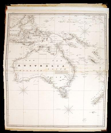
Cover: item 67
Terms and conditions: The condition of all books has been described. Each item may be assumed to be in good condition, unless otherwise stated. Dimensions are given height by width. All prices are net and do not include postage and packing. Invoices will be rendered in £ sterling. The title of goods does not pass to the purchaser until the invoice is paid in full.
Printed by Park Communications on FSC® certified paper. Park is an EMAS certified company and its Environmental Management System is certified to ISO14001. 100% of the inks used are vegetable oil based, 95% of press chemicals are recycled for further use and, on average 99% of any waste associated with this production will be recycled. This document is printed on Galerie Matt made of material from wellmanaged, FSC®-certified forests and other controlled sources. The pulp used in this product is bleached without the use of chlorine (ECF).
Under the Southern Cross
The Michael & Wendy Brown Collection
Ptolemaeus
Honter
Ortelius
Montanus
Bunting
Apianus
Mercator
De Jode
Le Clerc
Hondius
Visscher
Colom
Visscher
Campen
Blaeu
Janssonius
Baudrand
Valk
Senex
Senex
Seutter
Bowen
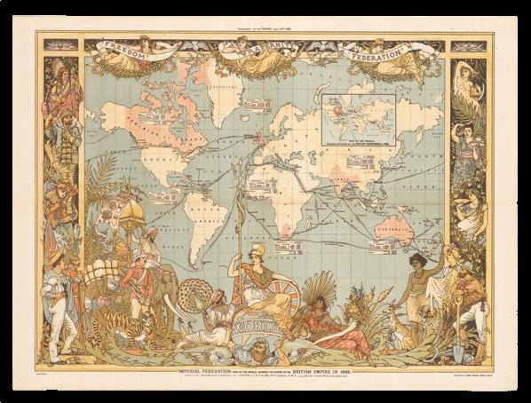
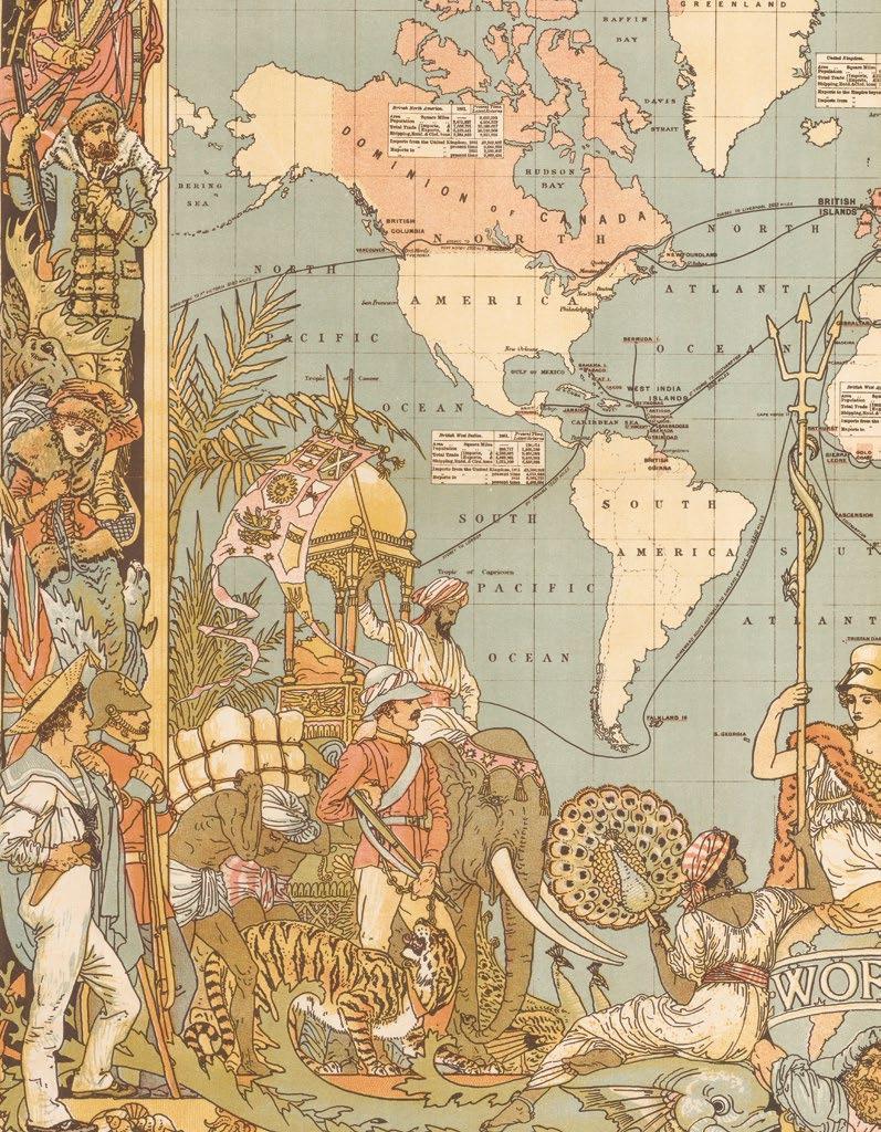
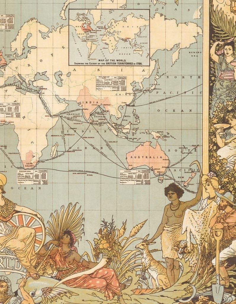
Jaillot
Robert
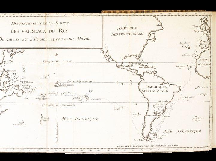
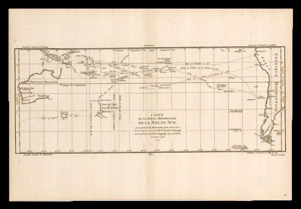
Bougainville
Reilly
Dunn
Cary
Crane
Metellus
Ortelius
Hondius
Janssonius
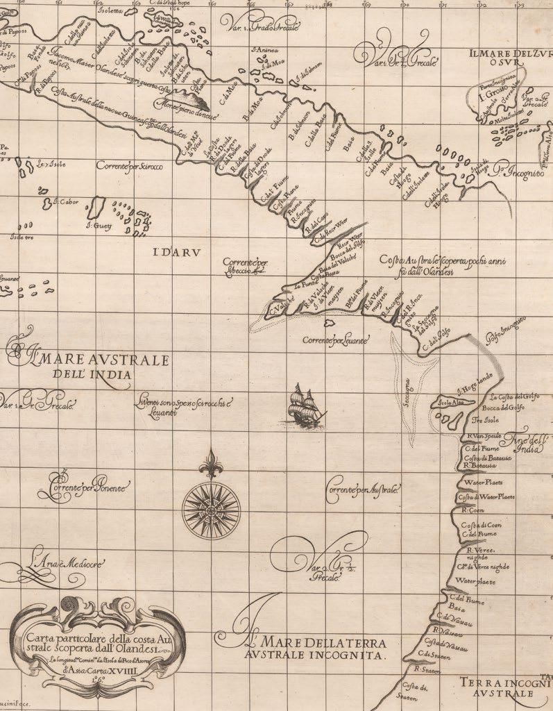
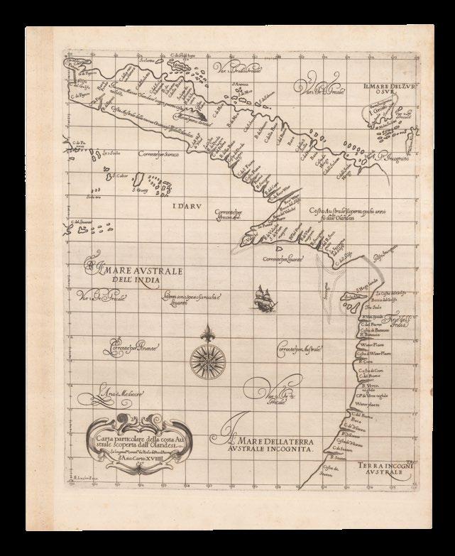
Thevenot
Keulen
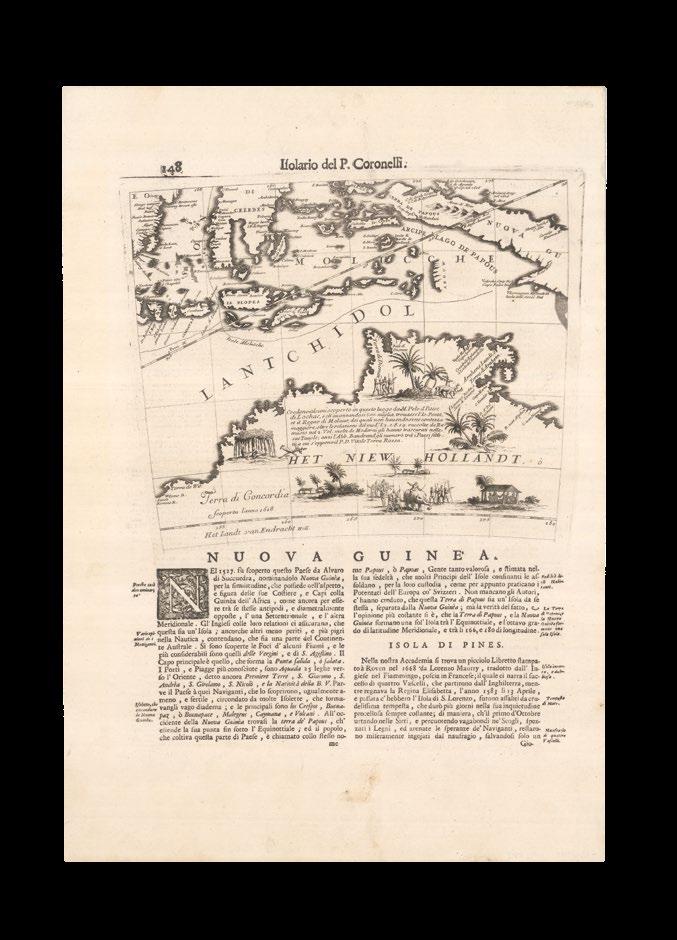
Coronelli
£15,000
£8,000
£2,000
£15,000
£10,000
£2,500
£3,000
£4,000
£40,000
£7,000
£15,000
£2,000
£12,000
£8,000
£2,000
£25,000
£7,000
£5,000
£1,000
£3,000
£2,000
£8,000
£300
£2,500
£2,000
£7,000
£3,000
£10,000
£4,000
£3,000
£35,000
£6,000
£4,000
Keulen
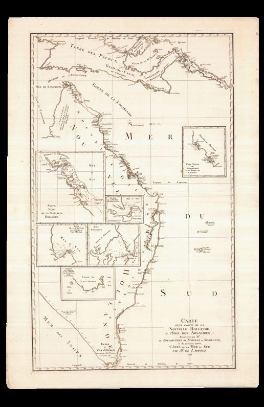
Laborde
Brosses Canzler
Callander Kincaid
Dalrymple
Bougainville
D’entrecasteaux
Freycinet
Parkinson Baudin
Cook Flinders
Kippis Flinders
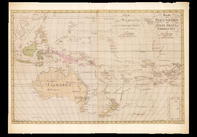
Djurberg Wyld
Dalrymple
Djurberg
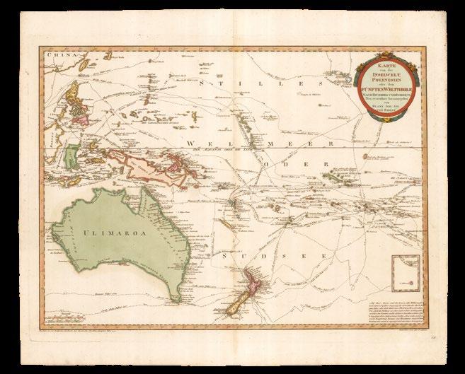
Reilly
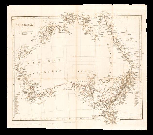
Arrowsmith
Arrowsmith
Johnston
Liechtenstern Everett
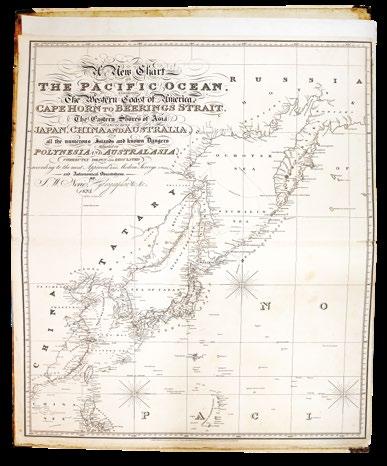
Norie
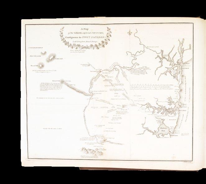
Phillip
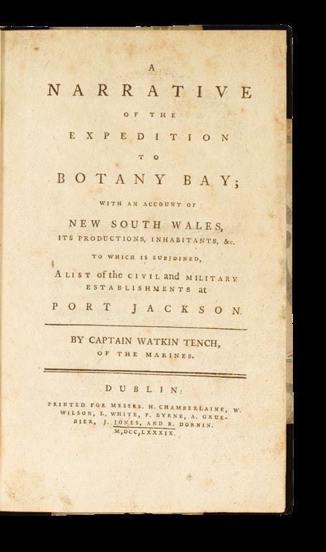
Vandermaelen Tench
Linschoten
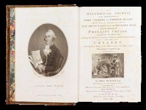
Hunter
Ortelius Flinders
Blaeu
Hondius
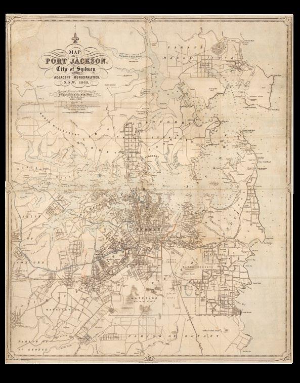
Cross
Cross
Janssonius Mitchell
De Wit Mitchell
De Rossi Eyre
Coronelli
£1,500 £3,500
Ham
Coronelli Degotardi
Scherer Phillip
Schraembl
White
Laurie Tench
Delarochette
Baudin
De Jode Baudin
Dudley Select Committee
Thevenot Bougainville
£18,000 £1,000
£2,000 £1,000
Valentyn Moriarty
Bowen Willis
Cassini
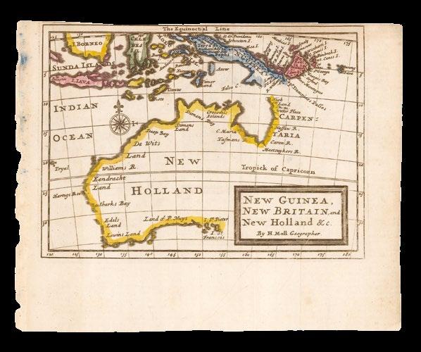
Coronelli Wells Hondius Dixon Moll King Withers
£5,000 £2,500
£2,500 £1,500
“Under the Southern Cross I stand” (probably Rod Marsh, after Henry Lawson, and the Rev. Thomas Hilhouse Taylor)
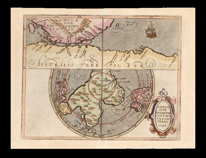
The discovery and exploration of Australia has long been framed as both an act of chance and of growing curiosity, shaped by the vast seas of the southern hemisphere and guided by the faint patterns of the stars.
For centuries, European cartographers imagined a great southern continent, “terra australis incognita”, existing as a balance to the known lands of the north. The southern cross thus emerged as both a navigational guide and a symbolic marker of discovery, uniting the myths of the imagined continent with the experiences of explorers who first traced its outlines. Yet the story of Australia is as much about enduring Indigenous presence as it is about the voyages of European navigators.
For tens of thousands of years, Aboriginal and Torres Strait Islander peoples had lived across the continent, developing sophisticated knowledge systems tied to the land and stars. Songlines, oral traditions, and navigation by constellations—including the guiding pattern of the southern cross— formed a deep spiritual and practical map that sustained diverse communities in every region.
When Dutch sailors first charted parts of the western coastline in the early seventeenth century, and, later, when James Cook sailed along the eastern shore in 1770, Europeans were entering a space that was already richly inhabited and understood. Yet their perspectives framed the continent as a new land waiting to be claimed, rather than a thriving cultural landscape. Sailing “under the southern cross” for explorers meant venturing into uncharted seas, but for Indigenous Australians it reflected continuity, belonging, and connection to country. This duality—of European discovery and Indigenous endurance—remains central to Australia’s history.
The 111 maps and books of the Michael and Wendy Brown Collection tell this story from the creatures of ancient European myth, via the monsters of colonialism, to the behemoth of globalisation and modern multi-cultural Sydney.
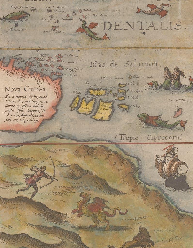
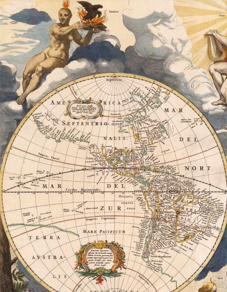
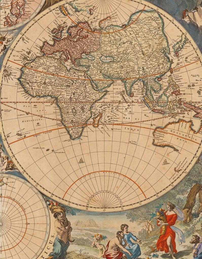
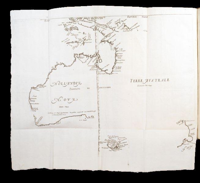
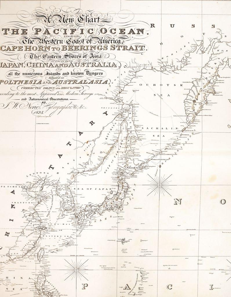
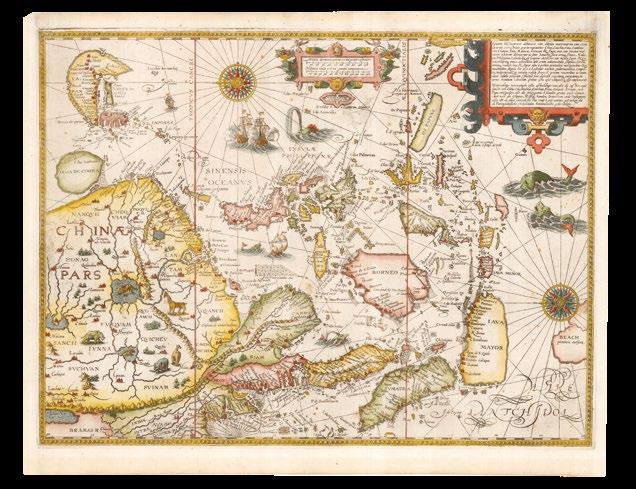
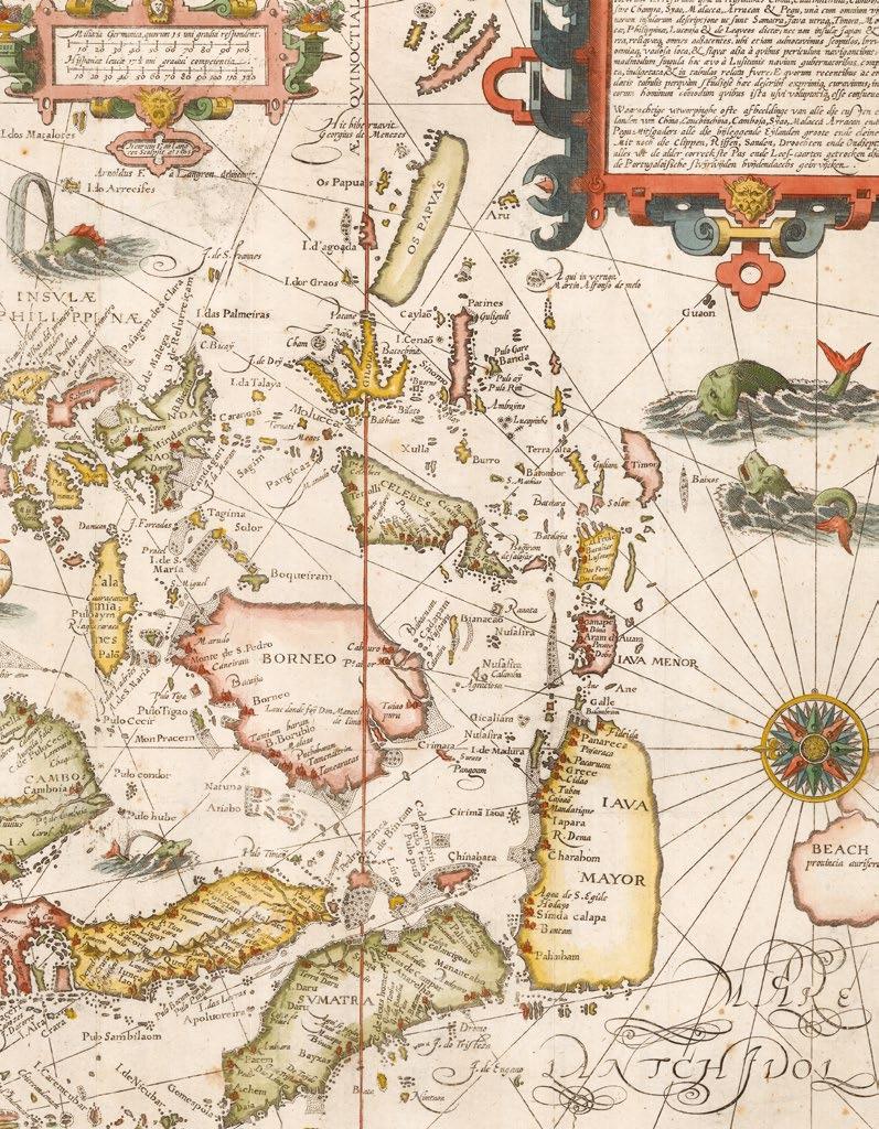
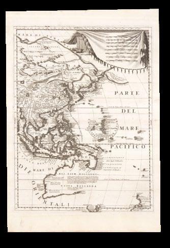
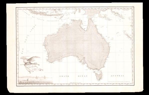
Cartographers love a good creature, and the makers of the earliest of the maps and charts in the collection delight in illustrating them: Munzer’s world map (1493) (item 1), and de Jode’s “northern Australia” (1593) (item 67) authoritatively depict the fantastical beasts and beings that were thought to inhabit the furthermost parts of the earth; the latter goes so far as to place a magical winged dragon at the heart of his map.
Once the Dutch began their systematic voyages of discovery to the East Indies, in the 1590s, and the true shape of “terra Australis incognita” was revealed by the cartographers of the VOC, these creatures, were soon banished. Initially, into the oceans, where they represented outlandish perils on the seas, as in the detailed maps of Linschoten (1595) (item 53); and then subsequently marginalised, to the elaborate borders of the
extravagantly decorated maps of Dutch powerhouses of the seventeenth century, Blaeu (item 16), Hondius (item 11), and their contemporaries. The art achieved its apotheosis in Nicolaes Berchem’s magnificent border for Visscher’s world map (1658) (item 14), setting a masterly precedent by weaving together classical mythology, and cosmic elements, with earthly seasons.
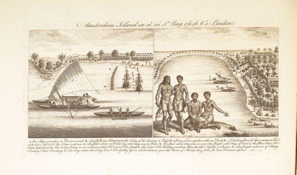
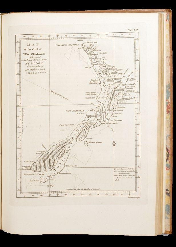
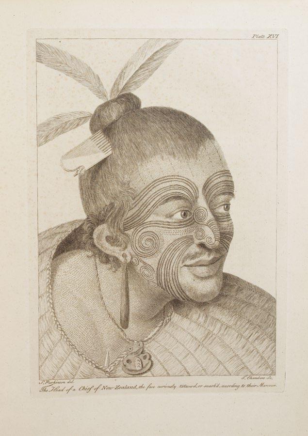
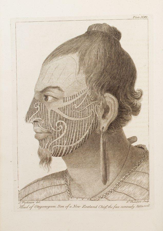
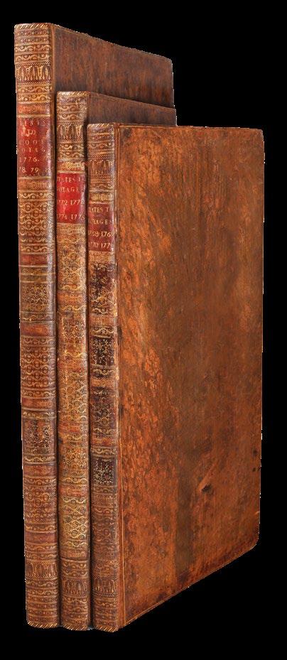
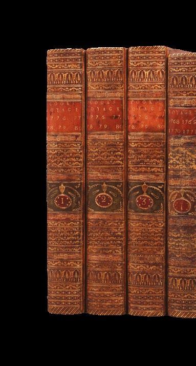
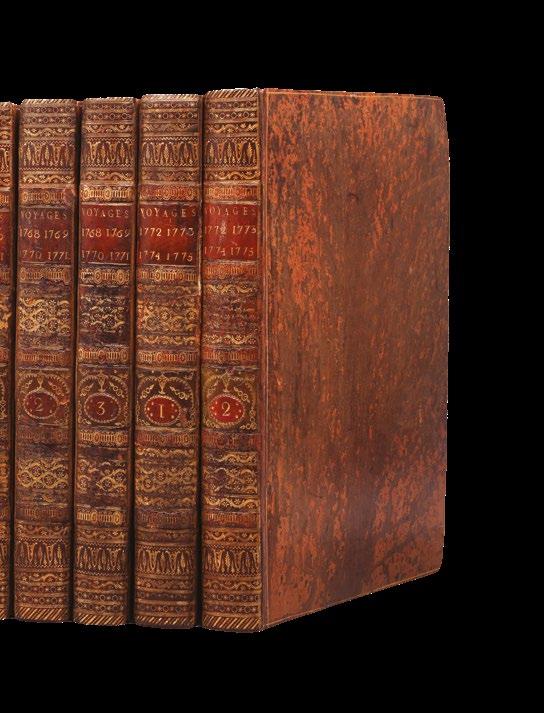
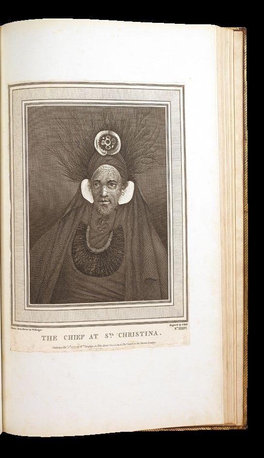
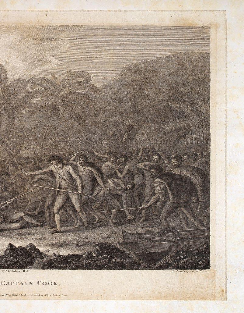
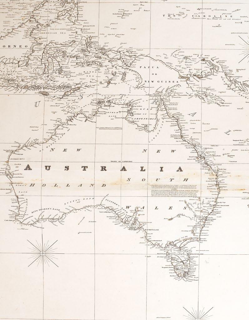
The zeal of scientific enterprise, that characterised much of the long eighteenth century, was eventually successful in uncovering the shores of a “Continent or Land of great extent”, and in the process discovered that indeed truth is stranger than fiction. The charts and plates that accompany the official accounts of James Cook’s voyages (item 44), reveal in meticulous detail the true, but still marvelous, nature of the flora, fauna, topography, and peoples of the lands his vessels touched, by some of the most talented artists of the day. Soon, Cook’s successors, including Freycinet (item 79), Flinders (items 80, 81, and 91), et al, were decorating the borders and cartouches of their charts with images of Australia’s soon to be displaced original inhabitants, alongside the topography of this new found land, enticingly ripe and ready for settlement.
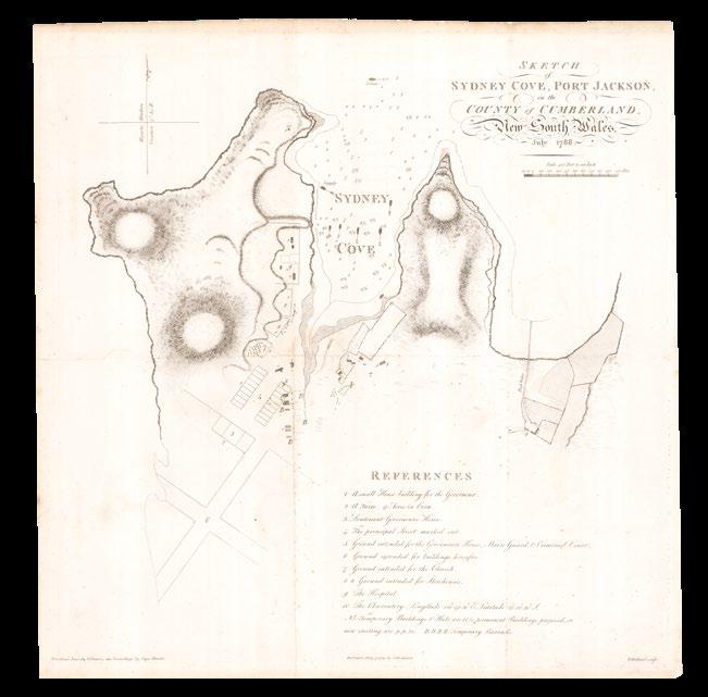
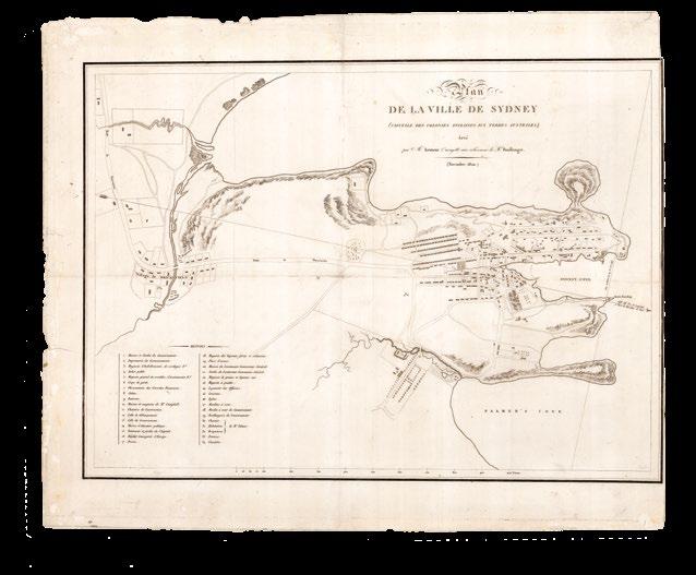
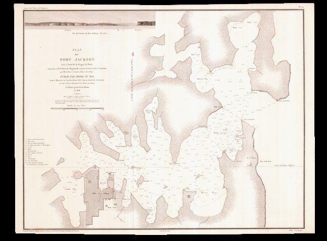
The all-too-real monstrosities wrought by the age of Colonialism, during the late eighteenth and early nineteenth centuries, happen largely “off-stage” in the Collection. Some of the trials and tribulations of the early years of settlement, and internal exploration, are recorded in the works of Phillip (1789) (item 88), Hunter (1793) (item 90), and co., but are more squarely addressed in the writings of Tench (1793) (item 102), and Basire’s plan of Sydney (1837) (item 105).
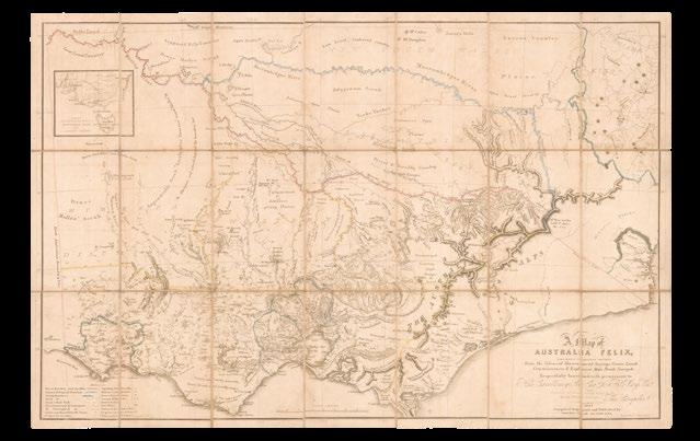
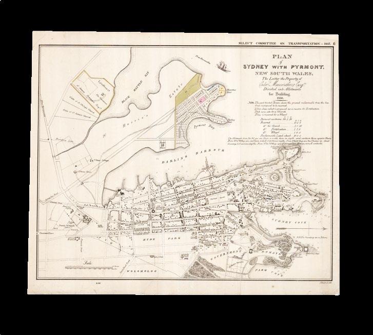
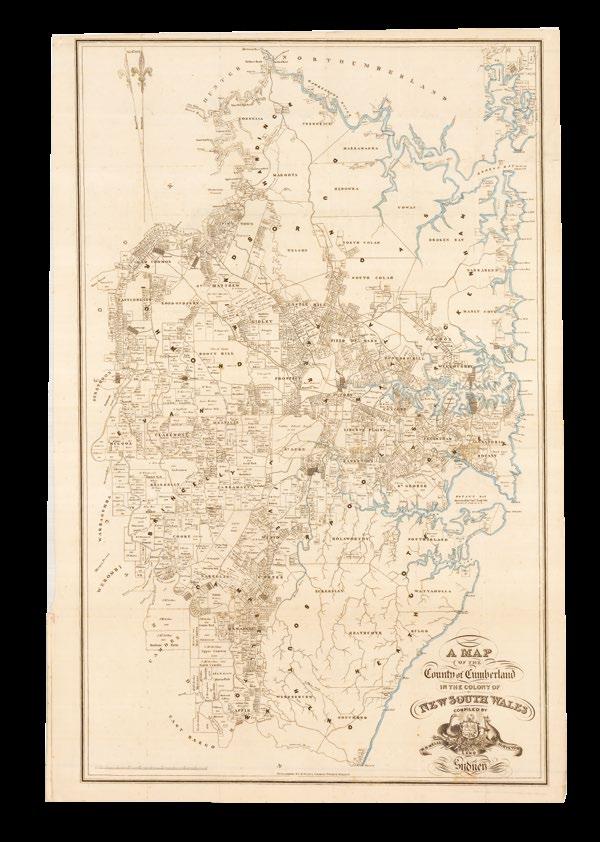
Instead, what emerges, particularly from the explorer and squatter maps of the settlement of New South Wales, and the early urbanisation of Sydney, is a people embracing their sunburnt country, and the apparent promise of Crane’s map (1886) (item 30): “Freedom, Fraternity, Federation”.
One day, some 40 years ago, I happened to be in Harrods department store in London, which, at that time, had an antiques maps section. I was fascinated by their maps, and acquired, for the grand sum of £40, an 1846 map of Australia by John Lothian (which I still have), and I was hooked. Although business priorities left little time for fossicking, I kept an eye out for interesting maps during my overseas visits, principally to London and the United States.
In 2005, my wife Wendy and I were again in London, and decided we should make our first substantial acquisition: the Willem Blaeu cartea-figures world map of 1630. From that time I began to focus my attention on maps which showed the emergence of Australia in world and regional maps, all of which are in the present catalogue.
I confess, at heart, to being an unbridled collector, starting off with an extensive collection of postage stamps when I was in school. The earliest map I collected, to show any of a charted Australia, is the Hendrik Hondius 1630 world map showing the discoveries in the Gulf of Carpentaria (item 11), and the collection gradually expanded through various world and regional maps, to the definitive map by Thevenot of 1663 (items 35 and 69).
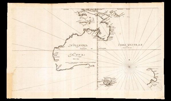
That eventually brought me to 1770 and the voyage of James Cook along the east coast of Australia. I was able to acquire an impressive complete set of the Cook voyages (item 44). After that time, maps by Cassini (item 74), Djurberg (item 46) and, of course, Flinders (item 81) bought the shape of Australia to essentially the same as we know it today.
Michael Brown
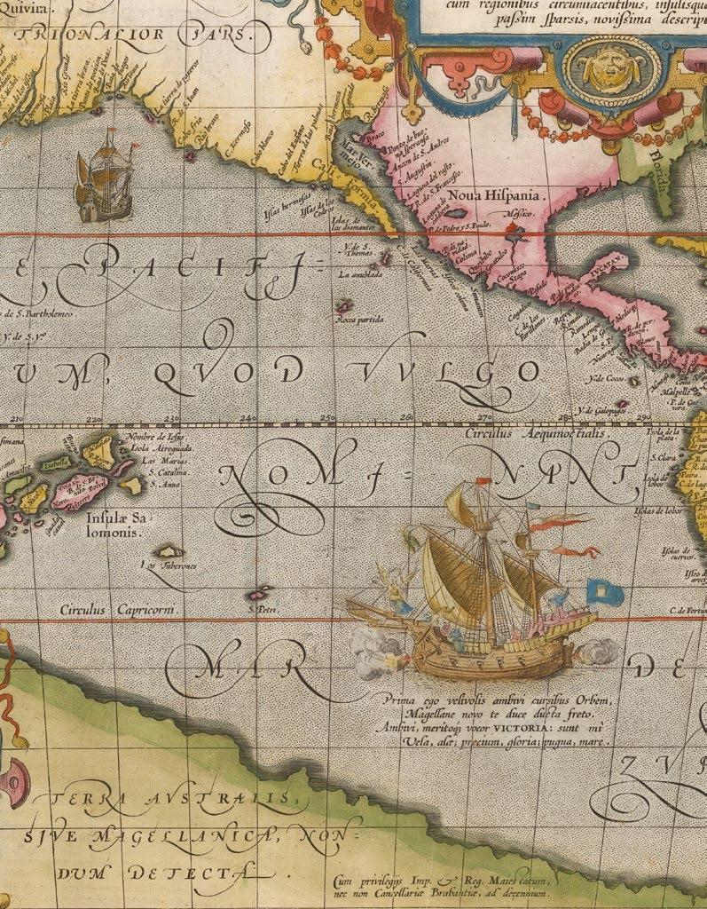
“Prima ego velivovis ambivi cursibus Orbem, Magellane novo te duce ducta freto. Ambivi, meritoque vocor VICTORIA: sunt mî Vela, alæ; precium, gloria: pugna mare” (Magellan’s ship the ‘Victory’, quoted by Ortelius)
[I was the first to sail around the world by means of sails, and carried you, Magellan, leader, first through the straits. I sailed around the world, therefore I am justly called Victoria (Victory), my sails were my wings, my prize was glory, my fight was with the sea].
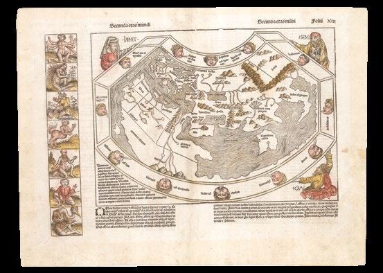
SCHEDEL, D. Hartman; and Hiernonymous MUNZER
Secunda Etas Mundi.
Publication Nuremberg, Anton Koberger, June, 1493.
Description Double-page woodcut map of the world, Latin text on verso, with contemporary hand-colour in part..
Dimensions 445 by 585mm (17.5 by 23 inches).
References Clancy, ‘So Came They South’, pages 9-11; Shirley, ‘The mapping of the world: early printed world maps, 1472-1700’, 19; Wilson, ‘The making of the Nuremberg Chronicle’ 1976, pages 98-122.
A distorted but clear depiction of the lands of the Far East
The world map from the ‘Liber Chronicarum’, or the “Nuremberg Chronicle”, a history of the world, published the year that Columbus returned to Europe after discovering America, while in search of Paradise, predicted by most medieval commentators to be in the farthest reaches of the earth, i.e. eastern Asia.
Geographically, the map is very similar to the small map added to a new edition of Pomponius Mela’s ‘Cosmographia’ (1482), published by Erhard Ratdolt. It “is a robust woodcut taken from Ptolemy… What gives the map its present-day interest and attraction are the panels representing the outlandish creatures and beings that were thought to inhabit the furthermost parts of the earth. There are seven such scenes to the left of the map and a further fourteen on its reverse… among the scenes are a six-armed man, possibly based on glimpses of a file of Hindu dancers so aligned that the front figure appears to have multiple arms” (Shirley). However, these images are balanced by more familiar and reassuring ones, as the map itself is dominated by the figures of Shem, Japhet and Ham, the sons of Noah whose descendants were believed to have re-populated the earth after the biblical Flood.
Generally, the map follows the classical belief of a landlocked Indian Ocean, with a distorted but clear depiction of the lands of the Far East, and the major innovation of the map is the inclusion of Portuguese discoveries on the west coast of Africa, accounting for the much longer coastline of the continent in comparison to previous Ptolemaic maps. In addition, this map also has a large unidentified island off the west of the continent, perhaps referencing Alvise Cadamosto’s discovery of the Cape Verde Islands in 1456.
The mapmakers
This world map is now thought to be the work of Nuremberg physician, humanist, and traveller, Hieronymous Munzer (1437-1508). A friend of Martin Behaim, the maker of world’s oldest globe, Munzer also contributed to the text of the Nuremberg Chronicle, the magnum opus of D. Hartman Schedel (1440-1514), a physician, an important Humanist, and book collector. Schedel’s comprehensive library, one of the largest personal libraries in late medieval Europe, eventually contained over three hundred manuscripts, and several hundred printed books, first came into the possession of Johan Jacob Fugger, of the Augsburg family of bankers, and patron of the “Fugger Binder”, in 1552, and was afterwards obtained by Duke Albert V of Bavaria (1550–1579) for the ducal, now royal, library at Munich.
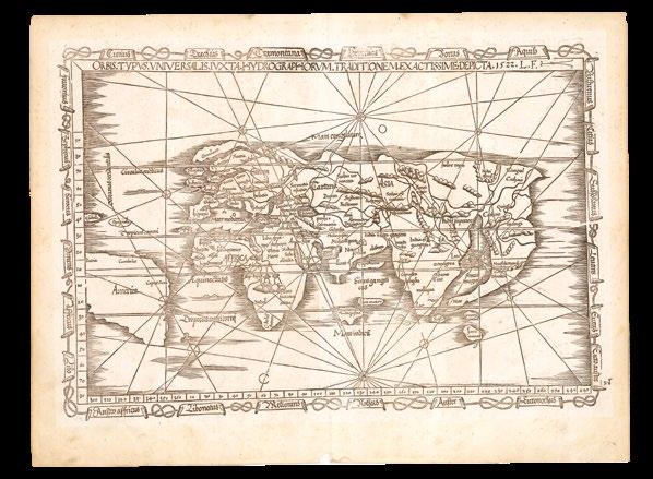
PTOLEMAEUS, Claudius; and Laurent FRIES
Orbis typus universalis iuxta hydrographorum traditionem Exactissime Depicta. 1522. L.F.
Publication Strassburg, Johannes Gruninger, 1522.
Description Double-page woodcut map.
Dimensions 322 by 480mm (12.75 by 19 inches).
References Shirley, ‘The mapping of the world: early printed world maps, 1472-1700’, 48; Suarez, ‘Early Mapping of Southeast Asia’, page 96, image 50.
An early crack at the modern world
One of the earliest printed maps in an edition of Ptolemy to include the name “America” (Shirley 48).
First published in 1522, this example is an early issue, in which the near horizontal crack, emerging from the righthand margin near the equator, is very short, and before the new title-banner, ‘Tabu. Totius Orbis’, was added. In this map of the modern world “Europe is very crudely drawn with England and Scotland reverting to separate islands. India, which was well defined on Waldseemuller’s great ‘Carta Marina’ of 1515 – to be re-issued by Fries himself in 1525 – has become a confusing double peninsula, with the largest southward-extending land mass being east of the Ganges delta. South America is shown in part, with the shape of its western coastline inserted more by intuition than by factual report. Magellan had indeed reached the Pacific via Tierra del Fuego in 1519 but his surviving ship did not reach the ports of Europe until September 1522, several months after publication of Fries’ work” (Shirley 48).
Issued in the first edition of Ptolemy’s geography to be edited by Michael Villanovanus, better known as Servetus (1511-1553), born at Villanueva, in Aragon, Spain.
The mapmaker
Laurent Fries had studied medicine at the universities of Pavia, Piacenza, and Montpellier, before establishing himself as a physician in the Alsace region and Switzerland, and eventually settling in Strassburg, in about 1519. There he met the printer and publisher Johann Grüninger, who worked with the Saint-Dié group of scholars, which included Walter Lud, Martin Ringmann, and Martin Waldseemüller. Grüninger printed several maps prepared by Waldseemüller, and supervised the cutting of the woodblocks for his 1513 edition of Ptolemy’s ‘Geographia’.
Fries’s first venture into mapmaking was probably in 1520, when he assisted Petrus Apianus in publishing a reduced version of Martin Waldseemüller’s wall-map of the world, first published in 1507.
Next, in 1522, Fries and Grüninger worked together on Fries’s own edition of Ptolemy’s ‘Geographia’, in which nearly all the maps were after those in Waldseemüller’s atlas. However, they added three new maps, of the world, of China and Japan, and Southeast Asia, as here. Laurent Fries’s 1522 edition of Ptolemy’s ‘Geographia’ is exceedingly rare, suggesting that the work was not initially commercially successful. Grüninger reissued the geography in 1525.
HONTER, Johannes Universalis Cosmographia.
Publication [Zurich, 1546, or later].
Description Later issue. Vignette woodcut map, German text beneath, with fine hand-colour in full.
Dimensions 208 by 175mm (8.25 by 7 inches).
References Shirley, ‘The mapping of the world: early printed world maps, 1472-1700’, 86.
A mini version of Apianus’s cordiform world map
Honter’s second world map based on Apianus’s cordiform world map of 1520 First published in Honter’s ‘Rudimenta Cosmographia’ (1546), it is preceded by a more basic version published in 1530. The current map is a later issue, in which the woodcutter’s initials and the date have been ommitted. The world map has been substantially updated from Honter’s 1530 edition.
The mapmaker
Johannes Honter was a Romanian scholar. He studied at the university of Vienna, alongside Peter Apian. He moved to Regensburg in 1529 to get away from the Ottoman advance on Vienna, and then went to visit Apian in Ingolstadt. He was also in contact with other important geographers of the age, including Simon Grynaeus and Sebastian Münster. Honter would eventually produce the first printed map of Transylvania. He converted to Lutheranism and spent the rest of his life dedicated to his new religion, founding a school and a printing press by 1539, where he specialised in educational works like the ‘Rudimenta’.
ORTELIUS, Abraham
Typus Orbis Terrarum.
Publication [Antwerp, Gielis Coppens van Diest, 1571].
Description
Double-page engraved map, with contemporary hand colour in full, heightened in gold, and with the addition of repaired crack to plate at lower left, and waves and cloud swirls in manuscript.
Dimensions 335 by 490mm (13.25 by 19.25 inches).
References Clancy, ‘The Mapping of Terra Australis’, 5.9; Shirley, ‘The mapping of the world: early printed world maps, 1472-1700’, 122; Van der Broecke, ‘Oertlius Atlas Maps’, 157L1.
“Who can consider human affairs to be great, when he comprehends the eternity and vastness of the entire world?” (Cicero, legend in the border)
A beautiful example of Ortelius’s first world map, created for his atlas ‘Theatrum Orbis Terrarum’, and therefore the first world map created for a uniform atlas. Printed from the first copper plate, of three, first published in 1570, it features a border of clouds running around the oval of the map, is signed by the engraver “Franciscus Hogenberg”, a bulge appears in the west coast of South America.
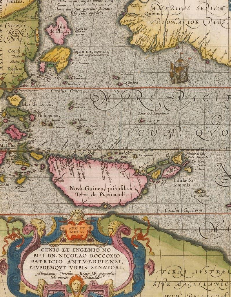
A number of legends appear in the vast southern continent, “Terra Australis Nondum Cognita”, including: “Hanc continentem Australem, nonnulli Magellanicam regionem ab eius inuentore nuncupant”, which explains that this Southern continent is also known as Magellanica, after its discoverer; and “Noua Guinea nuper inuentaquæ an sit insulaan pars continentis Australis incertû est”, questions whether New Guinea is part of the Southern continent or an island.
The mapmaker
Abraham Ortelius (1527-1598) took an active interest in cartography from an early age. He began his career as a “kaarten afzetter” (illuminator of maps) purchasing single (generally wall) maps from booksellers and colouring them for re-sale. He travelled extensively in his search for new material and was a well-known face at the Frankfurt bookfairs. It was whilst travelling that Ortelius built up his unrivalled web of contacts, which included many of the leading historians, scientists, and cartographer’s of the day.
These contacts would prove invaluable in the compiling and completion of his ‘Theatrum orbis Terrarum’ first published in 1570. The work was “the first true atlas” (van der Broecke): all the maps were of a uniform size and style, with an engraved title, accompanying text, and - hitherto unheard of in cartographic publications - a list of the source material. With its comprehensive scope, the atlas was a huge step forward compared with the contemporary “Lafreri” atlases, which were bound up to order and so reflected the whims of the customer. Even though it was the most expensive work published at the time, it proved an instant success with four versions of the first edition being printed in 1570 alone. The work would go on to be published for 42 years, with some 31 editions being produced.
MONTANUS, Benedictus Arias
Pars orbis... Benedict Arias Montanus
Sacrae Geographiae Tabulam ex antiquissimorum cultor familiis a Mose recensitis... Aø. 1571.
Publication Antwerp, Christopher Plantin, 1571 [but 1572].
Description
Double-page engraved map, with fine hand-colour in full.
Dimensions
325 by 540mm (12.75 by 21.25 inches).
References
Clancy, ‘The Mapping of Terra Australis’, 5.7; Rudge, ‘The Catholic Encyclopedia’ online; Shirley, ‘The mapping of the world: early printed world maps, 1472-1700’, 125, plate 1.
Potential Portuguese discoveries along the northern coast of Australia
This map holds a “special place in the early cartography of Australia” (Schilder). It was issued in the eighth volume of a polyglot Bible, which came to be known as the ‘Sacrae Regia’, printed by Christopher Plantin, and edited by Arias Benedictus Montanus between 1569 and 1572. The bible, with text in Hebrew, Greek, Latin, and Syriac, was dedicated to and largely paid for by King Philip II of Spain. Tragically, a large proportion of the entire printing of the final eighth volume was lost at sea on its way to Spain, so the first issue is very rare.
Based on the cartography of Giacomo Gastaldi, the map purports to show how Noah’s three sons repopulated the earth apres le deluge, but also includes a wonderful and mysterious anomaly: a landmass in the region and rough shape of northern Australia but not included in official Dutch records, until it was “sighted” during the voyage of the ‘Dufykin’ in 1606, therefore making a tantalizing claim for the “inclusion of Portuguese discoveries along the northern coastline, without any hypothetical southern land mass” (Clancy).
The current example is the second issue of this double-hemisphere map, with no text on the verso, and the word “Gentes” added to the panel of text lower left.
The mapmaker
Benedictus Arias Montanus (1527-1598), a scholarly Orientalist, was commanded by King Philip II of Spain, in 1568, to supervise and edit a new polyglot edition of the Bible. Arias included parallel Hebrew text with a translation by Leon de Castro, a fellow professor of Oriental languages at Salamanca. de Castro denounced Arias to the Spanish Inquisition for “having altered the Biblical text, making too liberal use of the rabbinical writings, in disregard of the decree of the Council of Trent concerning the authenticity of the Vulgate, and confirming the Jews in their beliefs by his Chaldaic paraphrases” (Rudge).
Arias was eventually freed of the charges in 1580, and thereafter mostly retired to his hermitage, but accepted the post of royal chaplain, looked after the Escorial library, and resumed his teaching of Oriental languages.
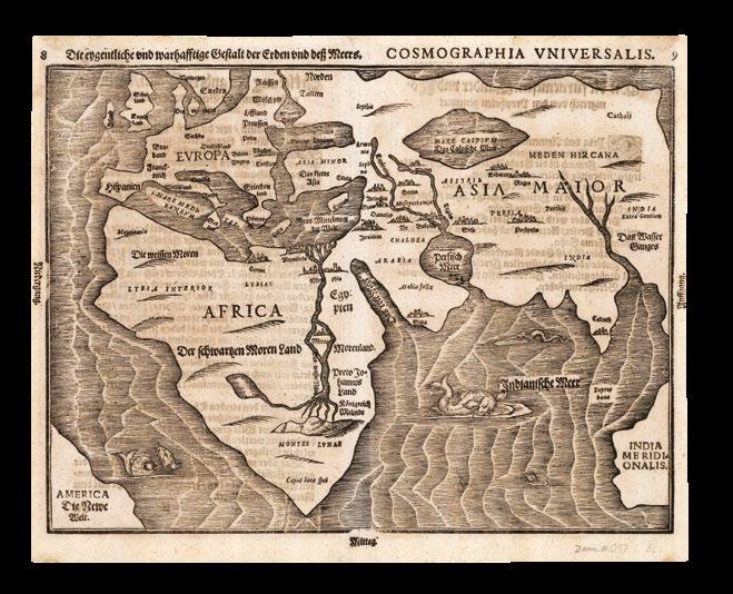
BUNTING, Heinrich
Die eigentliche und warhafftige gestalt der Erden und des MeersCosmographia Universalis.
Publication Magdeburg, Heinrich Bunting, 1581.
Description
Double-page woodcut, paginated “8” and “9” in respective upper corners, German text to verso.
Dimensions 288 by 372mm (11.25 by 14.75 inches).
References Clancy, ‘The Mapping of Terra Australis’, 5.8; National Library of Australia, Mawer for ‘Mapping our World: Terra Incognita to Australia’, page 87; Shirley, ‘The mapping of the world: early printed world maps, 14721700’, 143.
Pre-empting the discovery of Western Australia
Only the second published map to hint at early Portuguese discoveries of “Terra Australis”, the other being Benito Arias Montanus’s ‘Pars Orbis’ (1571). Published in Heinrich Bunting’s ‘Itinerarium Sacrae Scriptura’, and when compared to Bunting’s world map on a clover-leaf projection from the same book, his ‘Die eigentliche…’, it seems far more realistic view of the world, even pre-empting the discovery of Australia. By incorporating a landmass lower right, that conforms to coastline of Western Australia, as we now understand it, the map gives rise to “speculation that it reflects knowledge of an early discovery, perhaps by Portuguese navigators. The placement of Africa and India Meridionalis on the same parallel is remarkably accurate... [but] India Meridionalis is better explained as a survival from Ptolemy’s ‘Geography’” (Mawer).
The mapmaker
Having been twice dismissed from his ecclesiastic posts, German pastor Heinrich Bünting (1545-1606) was far more successful as a cartographer than a priest. His religious geography, the ‘Itinerarium Sacrae Scripturae’, was an exceedingly popular work, running to ten editions in seven languages during the decades following its publication in 1581.
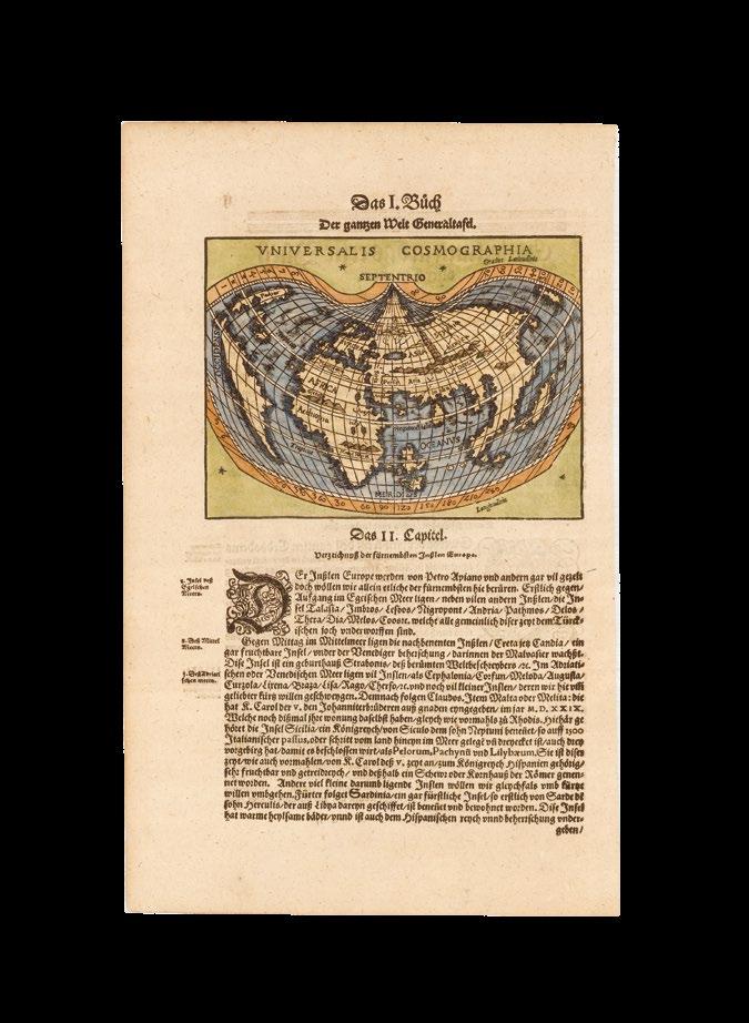
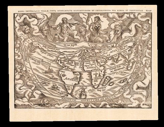
APIANUS, Peter; and Gemma FRISIUS
Typus Universalis Terrae, Iuxtra Modernorum Distinctionem et Extensionem per Regna et Provinciae. f.1348.
Description First woodblock, later issue. Double-page woodcut.
Dimensions 322 by 480mm (12.75 by 19 inches).
References
Shirley, ‘The mapping of the world: early printed world maps, 1472-1700’, 82, plate 70; Suarez, ‘Early Mapping of Southeast Asia’, page 197, image 113.
“Climata Australia”
This map, prepared by Gemma Frisius, to accompany Petrus Apinanus’s ‘Cosmographicus liber’ (1544). Frisius was an early proponent of the theory that a sea passage to the north of America existed that would allow quicker access to the Indies than the long southern route through the Strait of Magellan. He illustrates his theory in this map, which is also one of the earliest to show the entire east coast of North America. It displays the eastern side of North America as a narrow landmass, named “Baccalearum,” after the cod fisheries off the coasts of New England and Canada. The map uses Apianus’s original cordiform projection, and maintains the tantalising possibility of a northwest passage to Asia over the top of north America. The map is also notable for being the first printed map to depict the Yucatán as a peninsula rather than as an island, anticipating Ruscelli’s 1561 map of New Spain. Cuba and Hispaniola are shown as huge islands. Also prominent are the Mountains of the Moon, considered the source of the River Nile. The map is decorated with vignettes of animals, sailing ships and a mermaid. Signs of the zodiac and the Ptolemaic climatic zones border the map.
Zeus and Mars, wearing the coats-of-arms of Charles V, Holy Roman emperor, are shown above the map, while wind-heads at the south represent the traditionally believed plague-bearing nature of those winds. To the left of the map, “Climata Australia” appears just south of the equator. While this is technically the first appearance of “Australia” on a map, it refers to a climatic zone, rather than a landmass. Three woodcut blocks, from which the map was printed, have been identified. The current map is an impression of the first woodblock, with “Europa” at an angle and the outline of Britain without a caption. The first woodblock was known to have been sent to Paris in 1551, and new one cut for publication in Antwerp. The current example was published in Gregor Reisch’s ‘Margarita philosophica’, Basel, 1583.
The mapmakers
Petrus Apianus (1495-1552). In 1519, he moved to Vienna, where he was part of the second Vienna school of cartography, which included Georgius Tannstetter and Johannes Cuspinianus. In 1520, assisted by Laurent Fries, Apianus created a reduced version of Waldseemuller’s 1507, 12-sheet wall-map of the world, ‘Tipus Orbis Universalis’, on a cordiform projection. As Waldseemuller’s map is known in only one example, Apianus’s is the earliest obtainable map to name “America”.
Reinerus Gemma Frisius (1508–1555)
Reinerus Gemma, from Frisia (better known as Gemma Frisius) was a cartographer, astronomer, mathematician, physician, and maker of scientific instruments. He studied at the University of Louvain, and was appointed professor of medicine there, in 1541.
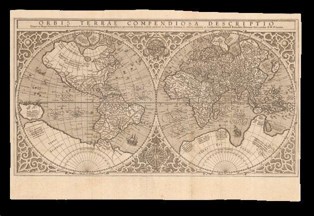
MERCATOR, Rumold
Orbis Terrae Compendiosa
Descriptio Quam ex Magna Universali Gerardi Mercatoris.
Domino Richardo Gartho, Geographic ac ceterarum bonarum artium amatori ac fautori summo, in veteris amicitie ac familiaritatis memoria Rumoldus Mercator fieri curabat A.o M.D. Lxxxvii.
Publication [Geneva, Eustathius Vignon], 1587.
Description First issue. Double-page folding engraved map, with no text beneath, nor on verso.
Dimensions 286 by 518mm (11.25 by 20.5 inches).
References Clancy, ‘The Mapping of Terra Australis’, 5.11, and page 70; Shirley, ‘The mapping of the world: early printed world maps, 1472-1700’, 157; Suarez, ‘Shedding the Veil’, 31.
A separately-published world map, issued prior to its inclusion in the first “atlas” to be so called
This double-hemisphere map of the world is a reduced version of Gerard Mercator’s revolutionary wall map of the world (1569), and was first published in Strabo’s ‘…Geographicarum libr XVII’, with text beneath the map headed “Lectori S.P.”, and without text on the verso. It may have also been published separately, and in the final part of Mercator’s atlas, before being included in Rumold Mercator’s complete five-volume edition of the atlas from 1595. However, the Mercator family were beaten to the post, in popularizing (and capitalizing on) this modern world view, by Abraham Ortelius, who included it as a simplified single sheet map in his atlas of the world, ‘Theatrum Orbis Terrarum’ (1570).
California shown as part of the mainland, there is the distinctive bulge in South America, and the kingdoms of Beach, Lucach and Maletur are shown as part of the mythical southern continent “Terra Australis”, which is shown as an entirely separate landmass: it “wraps around the fullest expanse of the southern latitudes possible, save for New Guinea, which is correctly shown as a separate island. ‘Terra Australis’ has, in addition, become a dumping ground for errors. It harbours a realm of parrots, ‘Psittacorum regio’, and serves as the refuge for lands reported by Marco Polo but which have been displaced because they are now duplicated by more recent data... On the opposite pole, Mercator has depicted the Arctic according to the four-island theory previously used by Ruysch and Finaeus” (Suarez).
The mapmaker
Gerard Mercator (1512-1594) would not begin his great ‘Atlas’ or “Cosmography” until relatively late in life. The impetus for this came when he was employed as cosmographer to Duke William IV of Kleve, in 1563. Mercator’s work is referred to as the first atlas, because he was the first to give a collection of curated maps this name, reflected in the famous engraved title-page showing King Atlas measuring the world with a pair of dividers. It is often wrongly thought that the word“atlas” refers to the Titan of the same name, whose punishment for fighting against the Olympian gods was to hold the heavens on his shoulders. It is instead a reference to King Atlas of the mythical Mauritania, a mathematician and philosopher who supposedly made the first celestial globe.
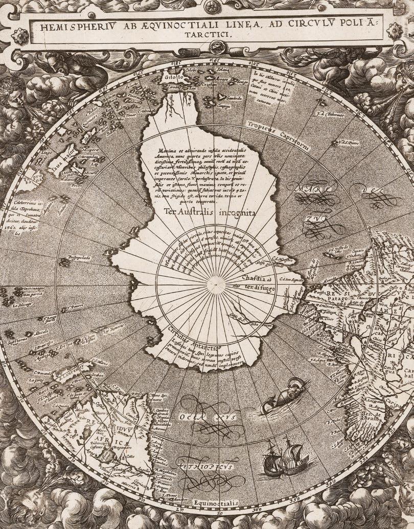
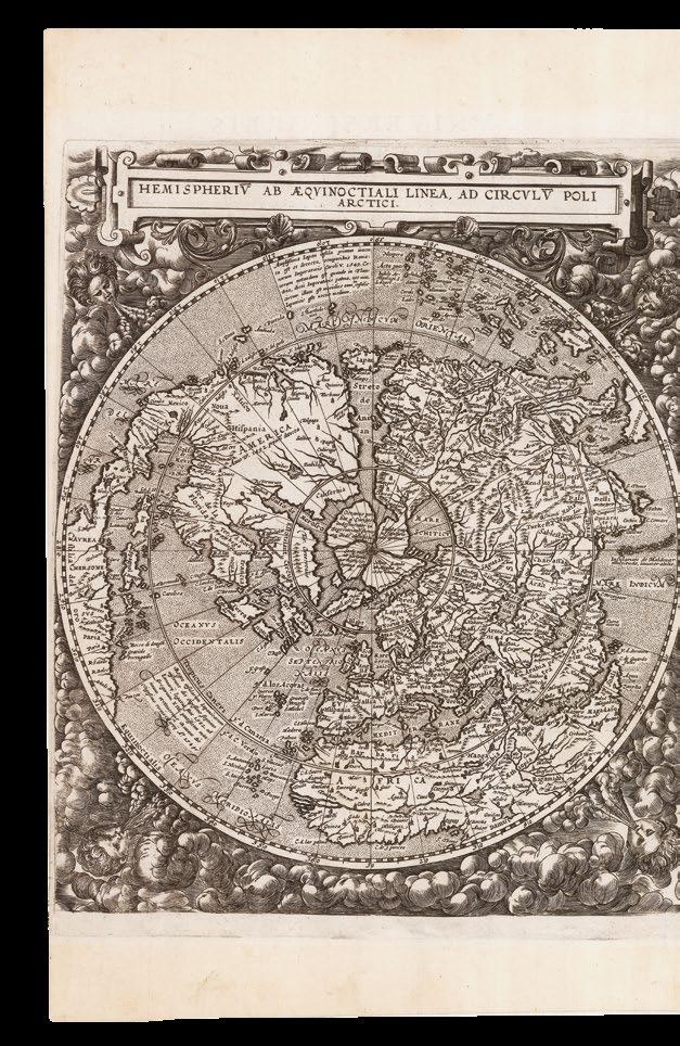
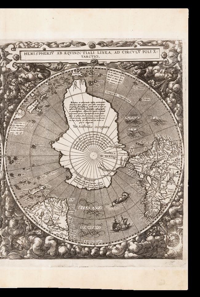
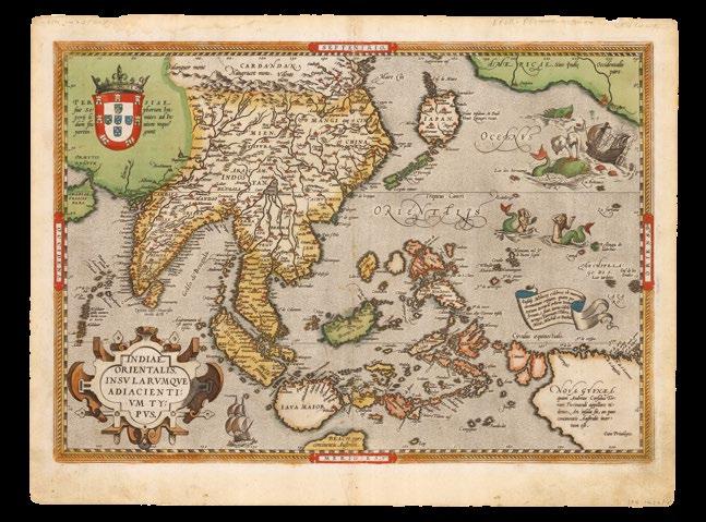
DE JODE, Cornelis
Hemispheriu ab Aequinoctiali Linea ad Circulu Poli Arctici. Hemispheriu ab Aequinoctiali Linea, ad Circulu Poli Atarctici.
Publication Antwerp, Arnold Corunx for the widow & heirs of Gerard de Jode, 1593.
Description Double-page engraved map.
Dimensions 323 by 523mm (12.75 by 20.5 inches).
References Shirley, ‘The mapping of the world: early printed world maps, 1472-1700’, 184.
De Jode’s striking world map on a north and south polar projection
One of the two new world maps published in the final edition of De Jode’s ‘Speculum’ in 1593.
The present map is extremely distinctive, drawn as two hemispheres on North and South polar projections, a style rarely used by sixteenth century cartographers. Drawing on a range of sources, particularly Guillaume Postel’s 1581 ‘Polo Aptata Nova Charta Universi’ and an anonymous set of gores from c1587, De Jode’s map demonstrates not only the wealth of geographical insight generated by early European exploration, but also the limits of contemporary knowledge. On the one hand, the Northern hemisphere presents the continents of Europe, Asia, Africa and North America in great detail. The cartography is generally accurate, most major cities are named and relief is shown pictorially. On the other hand, however, India is shaped quite irregularly, and several of the south-east Asian islands are incorrect, either in name or in location.
Similarly, while the American coast is well-drawn, the continent lacks many details, having not yet been thoroughly explored and mapped. It also contains a few mythical cities, such as Quivira and Civola. Similarly, although the land shown around the circumference of the Southern hemisphere is generally accurate, the second half of the map is dominated by the evidently erroneous ‘Terra Australis Incognita’. As a result of the polar hemisphere projection, the land closest to the Equator has been compressed; consequently, there appears to be little space between Asia and America, with Japan equidistant between the two continents.
The map appeared in the last edition of the de Jodes’ atlas ‘Speculum orbis terrae’. The ‘Speculum’ was first published in 1578 by Gerard de Jode (1509-1591) with text by Daniel Cellarius. It was designed to compete with Abraham Ortelius’ atlas, ‘Theatrum Orbis Terrarum’, which had been published eight years earlier. Ortelius had used his influence to disrupt de Jode’s application for a royal privilege. By the time this was finally granted, seven years after the publication of the ‘Theatrum’, Ortelius’ work had become so popular that de Jode’s atlas did not sell well, despite the accuracy and clarity of his maps. His son Cornelis (1558-1600) continued his father’s publishing business after studying at Douai. He produced an enlarged edition of the ‘Speculum’ in 1593, which Gerard had been planning before his death.
The present map appeared for the first time in that edition, along with another world map (Shirley 165). The individual maps may have been issued separately without text, prior to the publication of the atlas. Although sales of de Jode’s work were less than ideal, the atlas was evidently held in high regard, with several contemporaries citing its importance alongside the atlases of Mercator and Ortelius. Few examples of either edition of the ‘Speculum’ have survived, making the maps within a rarity.
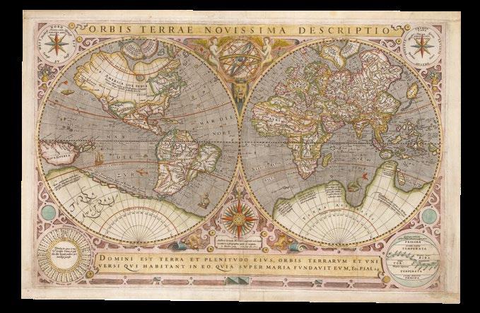
LE CLERC, Jean; and Jodocus HONDIUS I
Orbis Terrae Novissima Descriptio. Authore Gerardo Mercatore, nuperime vero iuxta recentiores Cosmographos aucta et recognita. I. Hondius sculp. I. le Clerc excu.
Publication 1602.
Description First issue. Double-page engraved map, with contemporary hand-colour in full, skilful restoration of blank margin at lower left, not affecting image.
Dimensions 330 by 515mm (13 by 20.25 inches).
References Shirley, ‘The mapping of the world: early printed world maps, 1472-1700’, 233.
The first appearance of the Gallego string
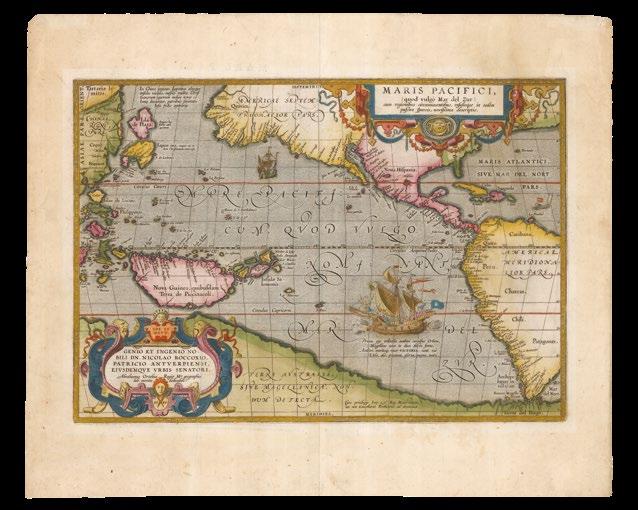
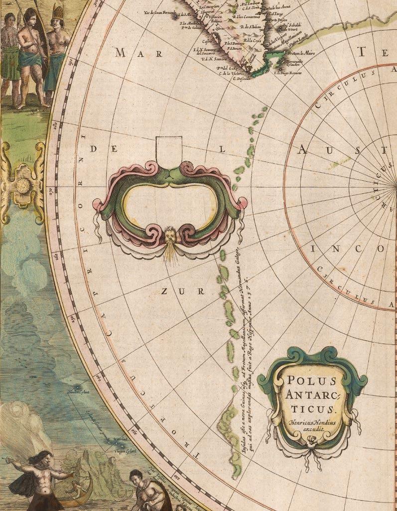
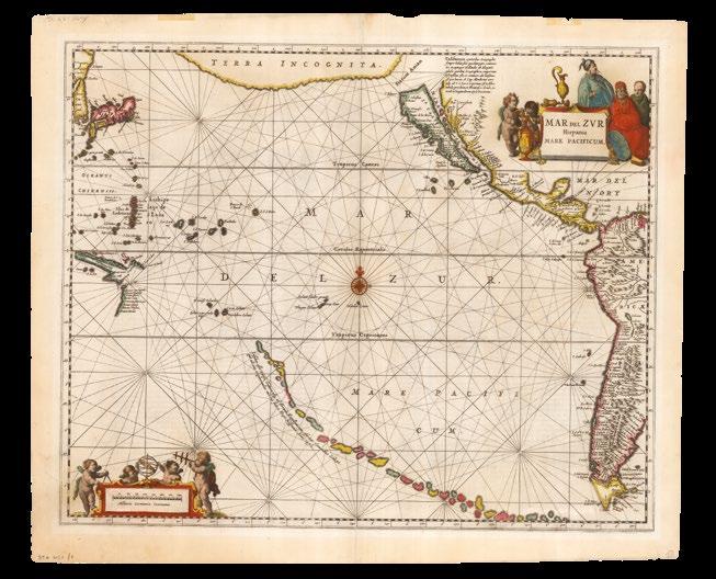
Dated 1602, but later impression with a crack appearing in the top lefthand corner of the plate. Published separately, but also found in MercatorHondius atlases of the time, and issued in conjunction with a series of maps of the continents, that of the Americas being dated 1589. The maps is “significant for its depiction of a string of Pacific islands that span the ocean from the tip of South America to just south of New Guinea, skirting what would be the north coast of Queensland. The only prior map to show this chain was a 1589 miniature, also by Hondius, known in only two copies (Shirley 164). Gallego explored off southern Chile in 1557, and sighted some Pacific atolls. The Gallego string was later popularised by Hondius in ‘Polus Antarcticus’ and Jansson in his Pacific map” (Brown).
Engraved by Jodocus Hondius I, after the work of his colleague Gerard Mercator, although the delineation of South America has been improved, and incorporates hypothetical information from Sir Francis Drake’s explorations. It anticipates Le Maire’s discovery of a sea route to the south of Tierra del Fuego into the Pacific. Drake, navigating towards the Magellan Strait, had suspected that open ocean lay south of the Tierra del Fuego, previously assumed to be part of the massive southern continent, Terra Australis, and that therefore the Pacific could be entered by sailing south around it. If that geography, as expressed on Le Clerc’s map, was correct then the monopoly held by the Dutch East India Company on all trade through the Strait, could be circumvented, allowing for an eastern entrance to the Pacific, and all the wealth that it contained.
It is likely that this map, as well as the so-called “Drake Broadside” engraved by Hondius several years earlier, helped influence Jacob Le Maire and Schouten in their voyages which sought to test the theory. Jacob’s father, Isaac Le Maire, organized an expedition under the auspices of a new company, the Compagnie Australe, which was granted a charter securing the rights to the first four voyages to countries it could discover by “new passages”. In the first of these, the voyage of 1615-1617, Jacob Le Maire and Captain Schouten succeeded in navigating what is now called Cape Hoorn. However, their expedition, perhaps the greatest of Dutch exploratory voyages, ended in Batavia in humiliation: the resident colonial officialdom did not [want to] believe the news and the implications of their discovery, and so seized their cargo, for infringing the VOC monopoly, and dispatched them back to Holland as prisoners. Le Maire did not survive the journey home.
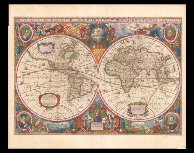
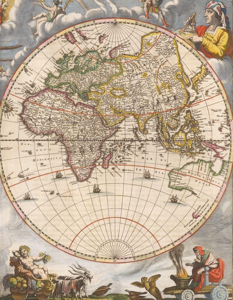
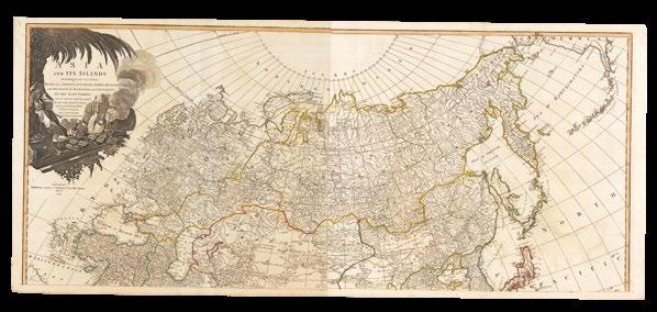
HONDIUS, Henricus
Nova Totius Terrarum Orbis Geographica Ac Hydrographica Tabula. Auct: Henri: Hondio.
Publication Amsterdam, Henricus Hondius, 1630, but from 1633.
Description
Double-page engraved map of the world, with German text on verso, in fine, full, original hand-colour, light toning to paper.
Dimensions 383 by 546mm (15 by 21.5 inches).
References
Clancy, ‘The Mapping of Terra Australis’, 1995, 6.2; Clancy, ‘So Came They South’, pages 72-74; Shirley, ‘The mapping of the world: early printed world maps, 14721700’, 336.
First issue of the first commercially available map to show Dutch discoveries along the northern coastline of Australia
Faced with increasing competition from the large cartographic house of Blaeu, Johannes Janssonius and his business partner Henricus Hondius set about revising the Mercator – Hondius atlas, and in particular the world map, which had remained unrevised for thirty-five years long years of exploration and discovery.
A magnificent example of this brand new, double-hemisphere map of the world, published in the ‘Gerardi Mercatoris et I. Hondii’ atlas from 1633 until 1658. It is the first dated map, “1630”, to show Dutch discoveries along the northern coastline of Australia, and therefore, the first commercially available map to show the full extent of Willem Janszoon’s voyage in the ‘Duyfken’. In 1606, Willem Janszoon, the captain of the ‘Duyfken’, sailed down the south coast of New Guinea and named a small piece of land “Duyfkens Eylant”, sailed across the Torres Strait, down the west coast of Cape York peninsula, as far as the Arukun Wetlands, assuming that it was still part of New Guinea.
Unlike Johannes Janssonius’s map, ‘Indiae Orientalis Nova Descriptio’ (1630), which shows only the New Guinea portion of Janszoon’s discoveries, the current map includes the area the ‘Duyfken’ sailed along the west coast of the Cape York peninsula. It also adds the discoveries of Jan Carstensz in command of the ‘Pera’ during his voyage of 1623, which followed the route of the ‘Duyfken’, and continued into the Gulf of Carpentaria. However, it omits, probably intentionally, the discoveries of Willem Joosten van Colster, in the ‘Arnhem’, and Dutch discoveries of the western Australian coastline of 1616 - 1627. Instead Hondius retains the “Beach” of Marco Polo, and only a vague outline for “Terra Australis”, still a mythical southern continent.
The map is more often noted for the extravagance of its decoration. The two hemispheres are surrounded by a complex border combining astronomical and physical cycles in order to link the earth in the centre to wider ideas of balance within the cosmos. The sun and moon appear in the cusps between the hemispheres. At the bottom is a representation of the continents of Africa, India and the Americas offering tribute to the enthroned Europe. At the top there is a celestial globe garlanded with fruits and flowers. In each corner are portraits of well-known cartographers: Julius Caesar, Claudius Ptolemy, Jodocus Hondius, and Gerard Mercator. Hondius has pointedly left out his contemporary Abraham Ortelius in favour of Ortelius’s competitor Mercator, and his own father who republished Mercator’s work.
Next to the portraits are personifications of the four elements shown as classical deities, along with animals at home in those elements. Fire is represented by Apollo driving a sun chariot, holding a phoenix and accompanied by a salamander and a dragon. Air is represented by Selene, surrounded by a pair of cranes and an eagle, and holding a chameleon, who was thought to live on air. Earth is represented by Demeter holding a cornucopia, with the exotic accompaniment of an elephant, camel and lion. Water is shown by Poseidon (or a river god) with a sea serpent and a whale.
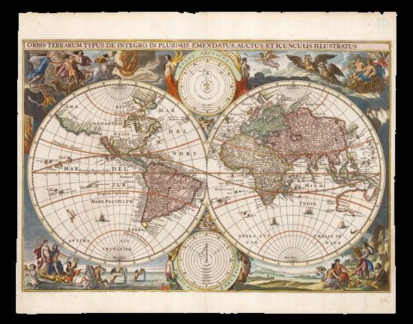
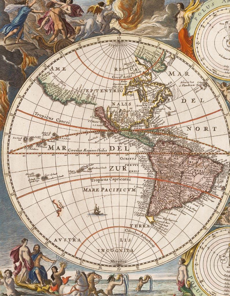
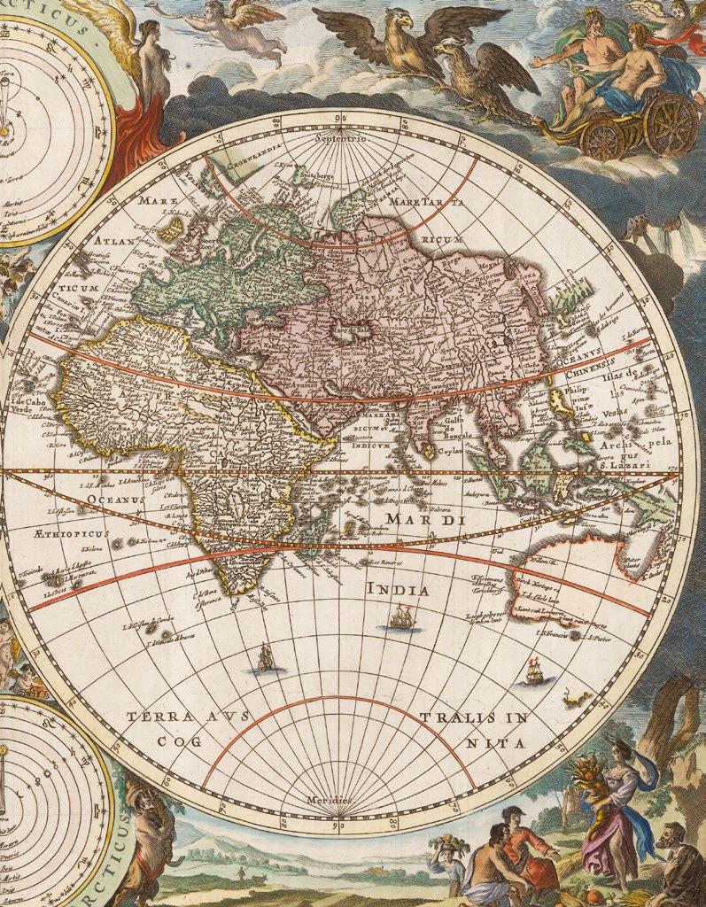
VISSCHER, Nicolaes [before, or maybe after]
Orbis Terrarum Typus De Integro In Plurimis Emendatus Auctus, Et Icunculis Illustratus.
Publication [Amsterdam, possibly Gedruckt by Theunis Jacobsz ende Jan Fredericksz Stam, maybe from 1648, but probably from 1657].
Description
Double-page engraved map of the world, with fine hand-colour in full.
Dimensions
322 by 475mm (12.75 by 18.75 inches).
References
See Clancy, ‘The Mapping of Terra Australis’, 6.11; cf. Schilder, ‘Australia Unveiled’, page 202; Shirley, ‘The mapping of the world: early printed world maps, 1472-1700’, 372(A) and 406; Woods, National Library of Australia, ‘Mapping our World: Terra Incognita to Australia’, page 149.
That is the question
An interesting hybrid double-hemisphere map of the world. The cartography is based mainly on Willem Janszoon Blaeu’s wall map of the world of 1648, and reuses the plate for Claes Visscher’s world map of 1614 (Shirley 288), although the hemispheres have been re-engraved to include the discoveries of Abel Tasman, and remove the northern coastline of a great southern landmass, which is still just visible. Nevertheless, the outlines of Australia and New Zealand, remain unfinished and are amongst the earliest on a world map to be based on the discoveries of Abel Tasman in 1642 and 1644. The coastlines of western America and eastern Asia and similarly open-ended, perhaps still allowing for the possibility that they are contiguous. California is shown as an island, and Alaska and the lakes of Canada do not appear at all.
The very elaborate and decorative border is the same as that for Nicolas Visscher’s ‘Orbis Terrarum Nova et Accuratissima Tabula’ (1657), by Nicolaes Berchem, a painter of pastoral landscapes. As with Visscher’s map, there are two smaller hemispheres in the cusps of the larger one, but they are quite different.
The map is unsigned, but an example has been found bound into an example of the ‘Het Nieue Testament ofte alle Boeken des Nieuwen Verbondts onses Heeren Jusu Christi’, (164?). A version of the map exists, but with a different border, bound into Dutch bibles published by Paulus van Ravesteyn, from 1657. Shirley writes: “the attribution of the original map to either Danckerts or Savry is still tentative, as is the provisional date... The doublehemispherical map was found in a 164[8]? Bible published by Theunis Jacobzs and Frederick Stam in company with five Holy Land maps either signed by Cornelis Danckerts, or dated 1648” (372A).
The map is significant for its magnificent border by Nicolaes Berchem, and is amongst those early maps which set the precedent for the famously intricately decorated Dutch maps of the later seventeenth century. In the border of this map, Berchem weaves together classical mythology and the elements: the corners show the rape of Persephone (fire), Zeus enthroned (air), Demeter amongst the harvest (earth) and Neptune in his chariot (water). The whole is presided over by personifications of the elements supporting the two polar projections. The cycle also roughly corresponds to the passage of the seasons.
“Benevole Spectator”
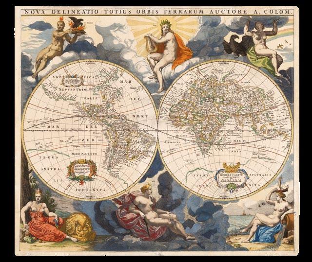
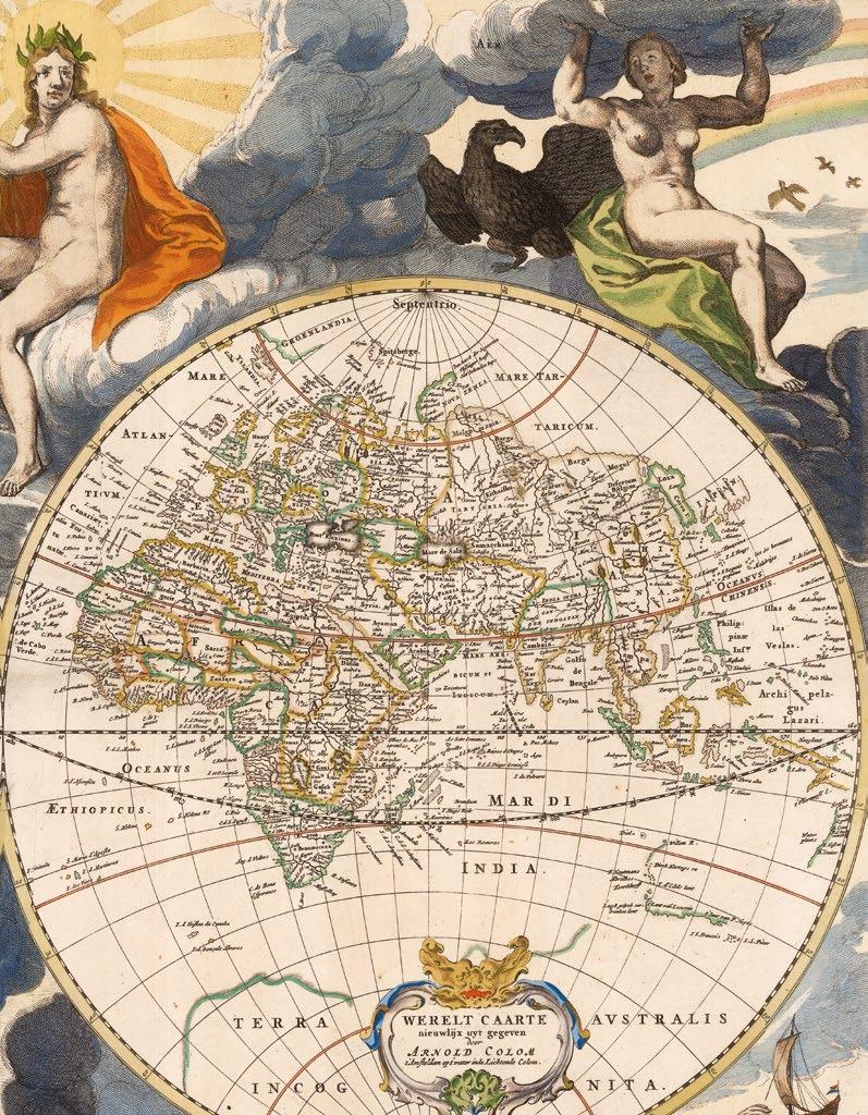
COLOM, Arnold
Nova Delineatio Totius Orbis Terrarum Auctore A. Colom.
Publication
Amsterdam, Arnold Colom, [1655].
Description
Double-page engraved map, with fine handcolour in full, laid down, repaired tears.
Dimensions 550 by 566mm (21.75 by 22.25 inches).
References
Shirley, ‘The mapping of the world: early printed world maps, 1472-1700’, 395; Suarez, ‘Shedding the Veil’, 37, plate XVII.
Arnold Colom’s version of his father, Jacob’s, world map, ‘Nova Totius Terrarum Orbis Geographica Ac Hydrographica Tabula. Auct. Iacobus Colom’ (1650), but with a brand new border. The cartography of both maps is very similar in style and geography to Henricus Hondius’s ‘Nova Totius Terrarum Orbis Geographica Ac Hydrographica Tabula. Auct: Henri: Hondio’ (1633, Shirley 336). However, Colom pere also borrowed from Hugo Allard’s ‘Nova Totius Terrarum Orbis Geographica ac Hydrographica Tabula. Auct. Hugo Allart’ (c1650, Shirley 378): the discoveries of Willem Janszoon and Jan Carstensz in northern Australia are recorded, just as in Hondius’s map, but Colom “improved” on Hondius by following Allard and adding a sketchy outline of Western Australia, with accounts of Dutch discoveries there, but not to the full extent of Abel Tasman’s voyages of 1642-1644.
Arnold’s map, as here, appears in his ‘Zee-Atlas’ from 1654 – 1658, and some examples of the ‘Werelts-Water-Deal’ of 1663. The two hemispheres are surrounded by six “robust statuesque figures typically representing Day and Night, and the four elements; each, except for Mother Earth, proudly unclothed. There are three small cartouches, one of which repeats the title in Dutch, one is a note to the “Benevole Spectator” (kind beholder) of the map, another relates to Christopher Columbus having discovered that part of the world in 1492” (Brown).
At some point, “the map came into the hands of Frederick de Wit who reduced its size by re-engraving a new title ‘Nova Totius Terrarum Orbis Tabula’ below the original top border” (1660 Shirley 421). De Wit also borrowed some of the elements from the border of Hugo Allard and Jacob Colom’s map, with a similar sun within a zodiac circle between swags of fruit and foliage at the upper edge, but the overall effect is superior in every way to the earlier maps.
The mapmaker
Arnold Colom, the son of Jacob Colom, was, like his father, a bookseller, printer, and chartmaker. He would appear to have produced only two maritime atlases throughout his career: a pilot of the Mediterranean, and a sea atlas of the world. The reasons for this are unclear although with the market so dominated by the likes of Janssonius, Goos, and Doncker, his work might have struggled to secure a foot-hold. However, his ‘Zee Atlas’, which Colom published between 1654–58, was one of the largest format sea atlases produced in Amsterdam, with each chart printed from an oversized copperplate. According to Koeman it is: “One of the most important atlases in the well known category of Dutch sea-atlases”.
VISSCHER, Nicolaes Janzsen
Orbis Terrarum Nova et Accuratissima Tabula. Auctore Nicolao Visscher.
Publication
Amsterdam, Auctore Nicolao Visscher, from 1658.
Description
Double-page engraved map of the world, with fine hand-colour in full, lower margin renewed.
Dimensions
468 by 558mm (18.5 by 22 inches).
References
Clancy, ‘The Mapping of Terra Australis’, 6.11; cf. Schilder, ‘Australia Unveiled’, 1976, page 202; Shirley, ‘The mapping of the world: early printed world maps, 1472-1700’, 406; Woods, National Library of Australia, ‘Mapping our World: Terra Incognita to Australia’, 2014, page 149.
“an elegant synthesis of science and art” (Woods)
Nicolaes Visscher’s map of the world is based mainly on Willem Janszoon Blaeu’s wall map of the world of 1648. The differences between the two are principally decorative, although Visscher has added two smaller hemispheres showing the earth from the two poles, reflecting contemporary demand for views of the world on different projections, based on Hondius’s prototypes.
The outlines of Australia and New Zealand, remain unfinished and are amongst the earliest on a world map to be based on the discoveries of Abel Tasman in 1642 and 1644. The coastlines of western America and eastern Asia and similarly open-ended, perhaps still allowing for the possibility that they are contiguous.
Terra Australis has been completely eradicated, and Vissher’s map was one of the first to dismiss the mythical southern continent so thoroughly: from both the main map, and the smaller south polar projection.
California is shown as an island, and Alaska and the lakes of Canada do not appear at all. The land of Anian appears in northwest America, first described by Marco Polo, the semi-mythical land was meant to be the first reached after traversing the Northwest Passage through the Arctic.
The map is significant for its magnificent border by Nicolaes Berchem, a painter of pastoral landscapes, and is amongst those early maps which set the precedent for the famously intricately decorated Dutch maps of the later seventeenth century. In the late 1600’s, a period of great geographical discovery, Amsterdam became an international center of the arts and of cartography, with engravers and printers produced magnificent maps and charts of every kind. The fields of artistic production and mapmaking were arguably more seamlessly united during this era than any period before or since, as the strong competition among publishers meant that maps not only had to be scrupulously accurate, but also visually appealing. In this milieu, a number of venerable firms, including those established by Blaeu, Jansson, Hondius, as well as Visscher, competed for the ever-expanding market for maps and atlases.
In the border of this map, Berchem weaves together classical mythology and the elements: the corners show the rape of Persephone (fire), Zeus enthroned (air), Demeter amongst the harvest (earth) and Neptune in his chariot (water). The whole is presided over by personifications of the elements supporting the two polar projections. The cycle also roughly corresponds to the passage of the seasons.
The mapmaker
The family firm was founded by Claes Jansz Visscher, whose grandfather had been a fisherman, as his name suggests, and fishermen are a recurring theme throughout Visscher’s engravings. Claes Jansz’s son Nicolaes (1618-1679) joined the business, probably at an early age. After the death of his father in 1652, he continued the business until his own death, and was then followed by his son Nicolaes II until 1702, when his wife Elizabeth Verseyl successfully continued the business until her death in 1726. Thereafter the shop came into the possession of the publisher Andries de Leth.
CAMPEN, Jacob van; and Jacob VENNEKOOL
Le Pave de la Grand Sale de Bourgeois.
Publication [Amsterdam, Gerald Valk, 1719].
Description
First edition in French. Folding engraved panorama, on 1 and a half joined sheets.
Dimensions 430 by 750mm (17 by 29.5 inches).
References Forsyth, ‘Australian Dictionary of Biography’, online.
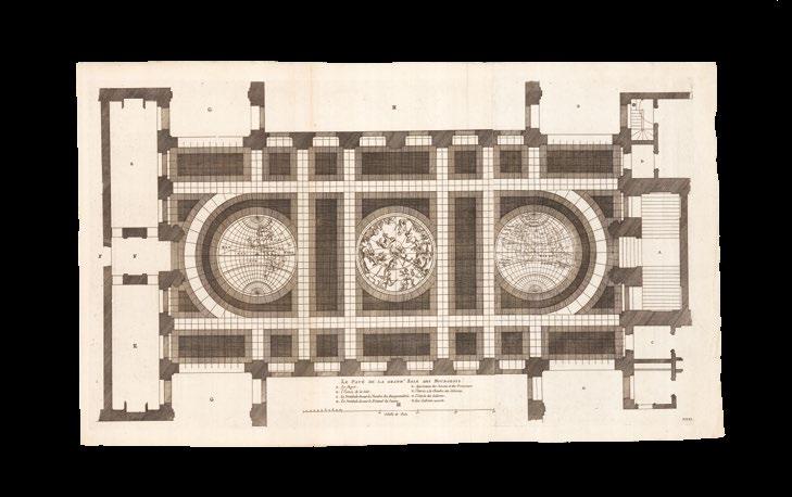
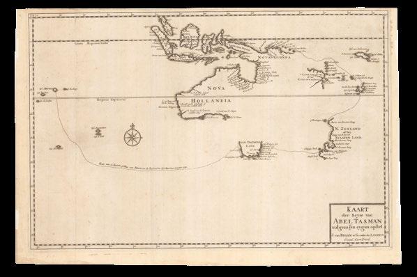
The first depiction of Abel Tasman’s discoveries, on a floor
This very early commemoration, in mosaic tile, of the discoveries of Abel Tasman was first laid on the floor of the Civic Hall in the Stadt Huys in Amsterdam in 1648, only four years after Tasman’s second voyage. It consists of the world in two hemispheres, either side of the northern night sky. Vennekool’s magnificent engraving was first published in Jacob van Campen’s work on the Stadt Huys, ‘Afbeelding van’t Stadt Huys van Amsterdam’ (1661). It was followed by a second depiction of Tasman’s discoveries on a floor at the entrance to the Mitchell Library in Sydney, Australia.
The mapmaker
Abel Jansz. Tasman (c1603-1659), was the first European explorer to reach and map the coastlines of Tasmania and New Zealand. After a series of shipwrecks had revealed some of the western coast of Australia, he was chosen by Anthony van Diemen, governor-general of the Dutch East Indies, to lead a voyage of discovery to the south, in 1642. The intention was to find a sea route south of Nuyts land, and east across the Pacific to South America. In his ships, the ‘Heemskerck’ and ‘Zeehaen’, over a course of ten months, Tasman mapped the coast of southwest Tasmania, the west coast of New Zealand, and the island groups of Tonga and New Guinea. On a second voyage, in 1644, Tasman and crew surveyed the southwest coast of New Guinea, and much of Australia’s northern coastline, as shown here.
Although the longed for southern sea route was not found,… the easterly’s were too strong, Tasman was awarded the rank of commandeur on his return, and a pay rise was backdated to the beginning of his first voyage. Subsequently, Tasman was “appointed to the Council of Justice at Batavia. In mid-1647 he was sent on a mission to the King of Siam and was granted precedence over all Dutchmen in the kingdom. After that mission, he was given command of a fleet of eight vessels which sailed in May 1648 against the Spaniards. His conduct in this operation was unsatisfactory and, after his return in January 1649, proceedings were taken against him for having, when inflamed by liquor, treated one of his sailors in a barbarous way; as a result, he was removed from office during the governor-general’s pleasure. He was formally reinstated in January 1651, but not long afterwards retired from the service and became a merchant in Batavia. He died there in affluent circumstances in 1659” (Forsyth).
BLAEU, Johannes
Nova et Accuratissima Totius
Terrarum Orbis Tabula. Auctore Ioanne Blaeu.
Publication Amsterdam, Johannes and Willem Blaeu, 1663.
Description
First issue. Double-page engraved map of the world, with superb contemporary handcolour in full, heightened in gold, Latin text to verso.
Dimensions 410 by 547mm (16.25 by 21.5 inches).
References Clancy, ‘The Mapping of Terra Australis’, 1.3; Shirley, ‘The mapping of the world: early printed world maps, 1472-1700’, 428.
The Blaeu family thoroughly updates their world map
A magnificent example of the Blaeu family’s new world map, depicting it in two hemispheres, was first published by Johannes Blaeu for his new 11-volume ‘Atlas Maior’ of 1662, replacing their map on a rectangular projection that they had been issuing since 1630. This map would also remain in circulation for decades. Evidently the original engraved copperplate survived the fire that destroyed the Blaeu printing works in 1672, and was subsequently acquired by the Van Keulen dynasty of mapmakers, being included in some of their atlases between 1681 and 1685.
Mostly, the map is a great improvement, cartographically, on the previous one: Australia and New Zealand are shown with their post-Tasman coastlines, gone is the mythical great south land, “Terra Australis”; “Nova Albion”, “Pt. Sr. Franco Draco”, and part of “Anian” are apparent; however, letting the side down a bit, California still appears as an island…
In the firmament, the sun and planets are personified, with the sun firmly in the middle of a concentric orbiting system. Possibly the first representation of Copernicus’s heliocentric system of the universe to appear on a map.
“As with all productions of the firm of Blaeu, the engraving and layout and elegance of decoration are all of the highest standard. The map is invariably printed on thick paper of quality and often superbly hand-coloured. Outside the twin hemispheres at the top are celestial figures seated amid clouds: below are representations of the four seasons with each allegorical figure seated in an appropriate chariot quaintly drawn by pairs of beasts and birds” (Shirley).
The mapmaker
Willem Janszoon Blaeu (1571-1638) was the founder of a cartographic dynasty: the finest mapmakers of the Golden Age of Dutch cartography. His sons joined him in the firm, with the eldest Joan (1596–1673) quickly taking control. Joan went to university in Leiden, studying mathematics and astronomy. After returning to work for his father, they produced their first atlas together in 1630, the ‘Atlas Appendix’. The title was deliberately chosen to position is as a supplement to the well-respected atlases of Abraham Ortelius and Gerard Mercator, and it mostly contained maps from their stock of plates. Five years later, they produced their ‘Atlas Novus’ with more than twice the number of maps in the ‘Appendix’, which was published in four languages. After Willem died, Joan expanded the ‘Atlas Novus’ into the ‘Atlas Maior’, the largest and grandest atlas of its time. Any issue had between nine and twelve volumes, beautifully engraved and coloured, and cost as much as a house in Amsterdam. He also issued a wall-map in 20 sheets in 1648, ‘Nova totius terrarium orbs tabula’. He continued to issue his father’s globes, only modifying the largest.
JANSSONIUS, Johannes; and Henricus HONDIUS
Nova Totius Terrarum Orbis Geographica Ac Hydrographica Tabula. Auct: Henri: Hondio.
Publication Amsterdam, Henricus Hondius, 1666.
Description Fourth issue. Double-page engraved map of the world, with contemporary hand-colour in full.
Dimensions 382 by 545mm (15 by 21.5 inches).
References Clancy, ‘The Mapping of Terra Australis’, 6.2; Clancy and Richardson, ‘So Came They South’, pages 72-74; Shirley, ‘The mapping of the world: early printed world maps, 1472-1700’, 336.
The rare fourth, final, and greatly revised issue, of the Mercator-Hondius double-hemisphere map of the world, first published in the ‘Gerardi Mercatoris et I. Hondii’ atlas from 1633 until 1658, when it was the first dated map, “1630”, to show Dutch discoveries along the northern coastline of Australia, and therefore, the first commercially available map to show the full extent of Willem Janszoon’s voyage in the ‘Duyfken’.
This example of the map was published for inclusion in Johannes Janssonius’s ‘Atlas Maior’, and is signed by him along the bottom edge, dated 1666. But most importantly the cartography is materially updated: to include a detailed depiction of the discoveries of Tasman’s two voyages along the coastlines of Australia and New Zealand; ‘t Land van Eso appears north of Japan; in the Pacific Northwest, the Straet de Vries and Compagnies Land are shown; in the South Pacific, Eyl. Rotterdam, Eyl Amsterdam and the I de S. Pedro, are noted; Korea is now an Isthmus; the Straits of Le Maire are shown between the southern tip of South America and Tierra del Fuego, although the nature of the relationship between Tierra del Fuego and a possible “Terra Australis” remains vague.
“On close inspection it is evident that there is additional hatching in many places, perhaps indicating the plate was refreshed at some time, e.g. the beards of Ptolemy and Mercator, the birds grasping Ptolemy, the fruit above Hondius and the cherub to the Ptolemy, and many other examples” (Brown).
The mapmaker
After Jodocus Hondius I’s death in 1612, his widow, Jodocus Hondius II and his brother, Henricus Hondius II (1597–1651), continued publishing atlases under his name until 1620. Unfortunately, in 1621 Jodocus Hondius II split with his brother, creating a rival publishing house. Henricus continued his father’s business with his brother-in-law, Joannes Janssonius (1588–1664), who had married twenty-four-year-old Elizabeth Hondius in 1612. After 1619, the Atlas was published under the name of Henricus Hondius, Jodocus Hondius’s son, but by 1629, the Blaeu family were becoming serious rivals to the publishing partnership of Janssonius and Hondius.
Rare: only a few examples of this issue have appeared in commerce in the last twenty years.
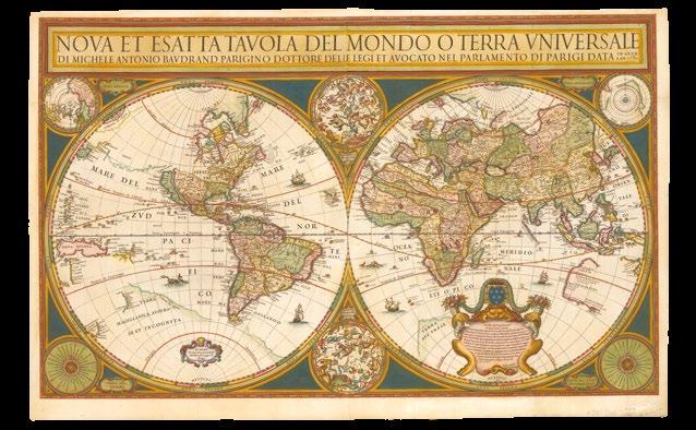
BAUDRAND, Michel Antionio; and Giovanni Giacomo DE ROSSI
Nova et Esatta Tavola del Mondo o Terra Univesale Di Michele Antonio Baudrand Parigino Dottore Delle Legi et Avocato Nel Parlamento Di Parigi Data in Luce L’An 1680.
Publication
Rome, Gio Giacomo Rossi, 1680.
Description
Double-page engraved map, on two joined sheets, with fine hand-colour in full, repairs to centrefold and righthand margin.
Dimensions 574 by 936mm (22.5 by 36.75 inches).
References
Shirley, ‘The mapping of the world: early printed world maps, 1472-1700’, 403.
A passage to Tasmania?
An interesting and rare map, first published in 1658, then 1668, and then, as here, unchanged, except for the date in the title banner.
The map is “heavily based upon Sanson’s world map of 1651 (Shirley 390/394), but with a unique configuration of the coastlines around Australia. The map details the discoveries of Tasman on both journeys, although he leaves out west Arnhem land. Baudrand shows a distinct strait at the base of the Cape York Peninsula, suggesting a passage to Tasmania. According to the late Simon Dewez, this is the first depiction of such a strait on a printed map, giving cartographic expression to the Dutch belief that it did exist. Baudrand clearly depicts New Guinea as a distinct island (as per Sanson), but drawn less accurately than Blaeu, with a distinct strait to the tip of the Cape York Peninsula, with a small piece of the Australian north coast appearing. More generally, the map has a large ornate cartouche with a dedication to Cardinal Azzolini. The outer border contains two celestial spheres, two polar projections and two circular wind diagrams. The extensive land “Iesso”, north west of California, is shown with a tentative coastline, other than the area supposedly reached by Vries north of Japan in 1643. Other special aspects are his depiction of Anian Strait, and the naming of the great lakes with three given their present day names (Superior, Huron and Erie). Traces of the coastline of “de Quir” and “Terre Australe” remain. Baudrand’s map in turn was the basis of the world maps of Pierre du Val of 1666 and 1668 (Shirley 441 and 443)” (Brown).
In the Pacific, New Guinea is outlined more correctly and placed separate from the Australian continent (called Nova Olandia) which is drawn less accurately than Blaeu and only shown in part. New Zealand is erroneously stated as having been discovered in 1654, instead of 1644. Traces of the old Coastline of Quir and Terra Australe remain.
The mapmaker
Abbe Baudrand (1633-1700) was geographer to the French king; credited with a number of academic works and not generally known as a cartographer. Rare: Shirley writes: “in spite of the imperfections, Baudrand’s map is a finely-engraved example of serious cartographical work. Partly because of its large size and the lack of any standard Italian atlases, it circulation was quite small and relatively few copies are known”; we are aware of one other example of this issue of this map in commerce, offered at Sotheby’s in 2002, and an example issued in 1668 held at the BnF.
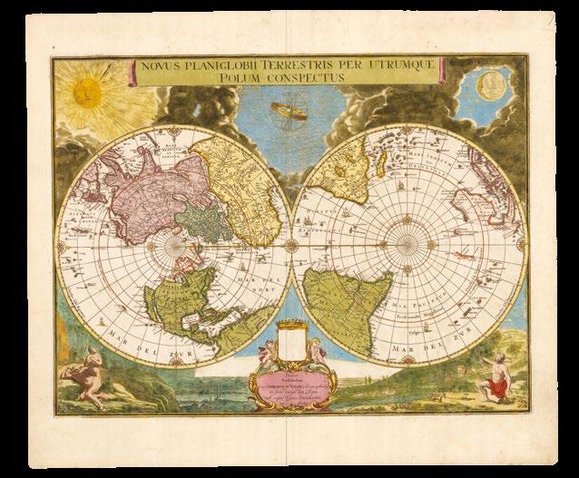
VALK, Gerald; after Johannes BLAEU
Novus Planiglobii Terrestris Per Utrumque Polum Conspectus.
Publication
Amsterdam, Penes Gerardum Valck calcographum in foro vulgo den Dam sub signo canis excubantis cum privilegio, c1695.
Description Engraved map, with contemporary handcolour in full.
Dimensions 410 by 544mm (16.25 by 21.5 inches).
References Clancy, ‘Mapping Antarctica’, 10.10; Shirley, ‘The mapping of the world: early printed world maps, 1472-1700’, 459.
“A milestone polar map” (Clancy)
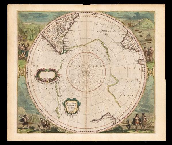
Originally engraved by Johannes Blaeu circa 1672, but apparently never issued by him, although his erased signature is just discernible beneath Valk’s imprint. “The map reflects the accuracy of Dutch cartography in the latter part of the seventeenth century, without trace of any hypothetical Antarctica, and included details of recent discoveries known to Blaeu through his position as chief cartographer with the Dutch East India Company” (Clancy).
The mapmaker
The Valk family firm was one of the most highly respected and enduring manufacturers of globes and maps in Europe. Gerard Valk, the family patriarch, apprenticed in London in the 1670s under the mapsellers David Loggan and Christopher Browne. Following his return to Amsterdam, in 1687, he formally established his own business, often working in concert with his brother-in-law, Petrus Schenk. Valk and Schenk would famously go on to produce an edition of Cellarius’ Harmonica Macrocosmica (1708). While Valk was initially known for his monumental wall maps, he was tutored in the exceedingly difficult craft of globe-making by Pieter Maasz Smit, who specifically praised Valk in his 1698 treatise on globe making.
In 1700, Valk moved his enterprise into the Amsterdam shop formerly occupied by the legendary Jocodus Hondius.
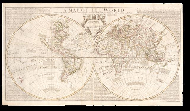
SENEX, John; and John MAXWELL
A Map of the World Corrected from the Observations Communicated to the Royal Societys of London and Paris.
Publication
London, Sold by Them at their House in Salisbury Court near Fleetstreet, 1711.
Description
First issue. Large double-page engraved map on two joined sheets, with contemporary hand-colour in outline.
Dimensions 586 by 1077mm (23 by 42.5 inches).
“A most dismal description of New Holland” (Brown)
The scarce first issue of this magnificent double-hemisphere map of the world. On this early version, California is still shown as an island, New Albion is named, and Port Sir. F. Drake shown. Above Cape Blanco is the supposed Strait of Anian, and there is a note that “These parts being as yet undiscovered, ‘tis not certain whether America joins to the North-Eastern part of Tartary, whence it is most probable that it was peopled, being suppos’d to be separated, if at all, but by narrow straits”.
Within the map are “additional observations, notably a most dismal description of New Holland: “The Soil of Hollandia Nova is barren and Desart, no fresh but some salt water Rivers, no fourfooted Beasts except an Amphibious one as big as a Dog, with Sea Cows, and innumerable quantities of Rats as great as Cats, and black Swans and Parots; the Natives are Black and go naked; the Coast is low, foul and rocky, the inland parts high. Here abound Oysters, Lobsters, and Crabs, and vast numbers of troublesome Flies. Mr. Witsen. Phil trans No. 245”. This note is from Nicholaes Witsen’s paper ‘Observations in New Holland’, presented to the Philosophical Society in 1698. He was a knowledgeable and well connected Dutch statesman, once mayor of Amsterdam and administrator of the VOC” (Brown).
The map is surrounded in the margins with lengthy treatises: ‘The Theory of the Tides from Sr. Isaac Newton’s Phil. Nat. Pinc. Math’, ‘An attempt to assign the Physical cause of the Trade Winds and Monsoons by Dr. Ed. Halley’, and ‘An attempt to assign the Physical cause of the Trade Winds and Monsoons by Dr. Ed. Halley’. Senex’s partner, John Maxwell’s name is retained in the title.
The map was first co-published by John Senex and his then-partner, John Maxwell, in 1711, with both their names in the cartouche, and subsequently reissued, with variations, several times until around 1750.
The mapmaker
John Senex (1678-1740) was one of the most important English mapmakers and publishers of the first half of the eighteenth century. He was apprenticed to the important bookseller and publisher Robert Clavell, but an early association with Jeremiah Seller and Charles Price diverted him to a career as surveyor, cartographer, globemaker, mapseller and map publisher. Such was his contribution to the development of the British map trade in his lifetime, that he was honoured and recognised in 1728 by his election to the Royal Society, sponsored by some of the greatest scientists of the period.
SENEX, John
A New Map of the World from the Latest Observations. Revis’d by J. Senex. Most Humbly Inscribed to his Royal Highness George Prince of Wales.
Publication [London, Daniel Browne, 1721].
Description Double-page engraved map, with contemporary hand-colour in outline and in part.
Dimensions 586 by 1077mm (23 by 42.5 inches).
An interesting map of the world from Senex’s ‘A New General Atlas, containing a Geographical and Historical Account of all the Empires, Kingdoms and other Dominions of the World... The maps... are all engraven or revised by Mr. Senex, etc’ (1721).
Hedging his bets, Senex, depicts alternative, lightly draw locations for Australia, New Zealand, New Guinea, various parts of Asia, Africa, Arabia, South America, “etc reflecting earlier knowledge of the various lands whereabouts. As well as the alternative outlines noted above, there are speculative outlines for the Solomon islands and a northern Pacific land. Interestingly, there are no outlines in the Antarctic region. Some descriptions of this map say that the outlines reflect geographical uncertainties at the time of its publication, but, on review, it is likely to represent some earlier guesses to illustrate advances in cartography then having been made to enhance the perceived accuracy to this map” (Brown).
Surrounding the main two hemispheres are four smaller projections, of the north and south poles, two on the plane of the equator, and two on the plane of the horizon of London (in the case of the south pole, the antipode of London, as marked). There is also an armillary sphere flanked by two figures (Atlas and Hercules) and other scientific drawings.
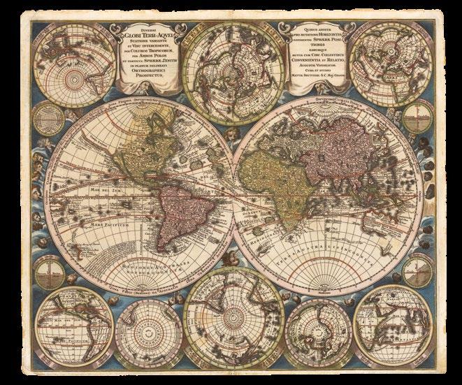
SEUTTER, Matthias
Diversi globi terr-aquei statione variante et visu intercedente per coluros tropicorum per ambos polos et particul. Sphaere Zenith in planum delineati orthographici prospectus.
Publication [Augsburg, Mattheus Seutter, 1730, or later].
Description
Double-page engraved map of the world, with contemporary hand-colour in full.
Dimensions
500 by 583mm (19.75 by 23 inches).
References
Portinaro & Knirsch, ‘The Cartography of North America 1500-1800’, 119; Shirley (BL Atlases) T.SEU-2a, 3.
One of the most dramatic world maps of the eighteenth century
One of the most dramatic world maps of the eighteenth century, Seutter’s map follows the 1696 ‘Planisphaerium Terrestre…’ of Carel Allard, very closely (see Shirley 578). The familiar western and eastern hemispheres are complemented by an array of smaller hemispherical projections, including polar, oblique and a pair that centre on the Indian and Pacific oceans. The four small diagrams show latitudes, longitudes and the tilt of the earth’s axis.
In all the projections, California appears as an island five times, with ‘Terra Essonis’ extending west from North America. Japan incorporates a large ‘Terra Yedso’ (Hokkaido). The coastlines of Australia and New Zealand are emergent, and New Guinea is shown twice, once in each of the larger hemispheres. The map shows the tracks of several explorers, and the whole is surrounded by a decorative border of wind-heads and clouds.
Published in Seutter’s ‘Atlas Novus’ from 1730.
The mapmaker
Mattheus Seutter (1678-1757) III, was an engraver, globe-maker, and publisher of maps and views in Augsburg. “Originally apprenticed as a brewer, he broke off that training and was apprenticed to J.B. Homann in Nuremberg, the leading map publisher of that time and later set up business in his native Augsburg together with his son, Albrecht Karl (1726-1762); he was joined in 1740 by his son-in-law Tobias Conrad Lotter, who had married his daughter Euphrosina in 1740. After Albrecht’s death, his widow had no interest in continuing the business, so she sold it to Johann Michael Probst and Tobias Conrad Lotter, equally. Ritter (2002) points out that, by 1717, Seutter’s tax was a total of 1 guilder, based on capital; below the average for the 50 tax-paying copper engravers in Augsburg. However, by 1731 or 1732, Seutter had earned due recognition and was given the title of Imperial Geographer by the German emperor Karl VI, and in 1741 was granted a printing privilege, as evidenced in the second state of this map” (Hubbard). Seutter first published his ‘Atlas Geographicus’ in 1728 and subsequently expanded it under the title ‘Atlas Novus’.
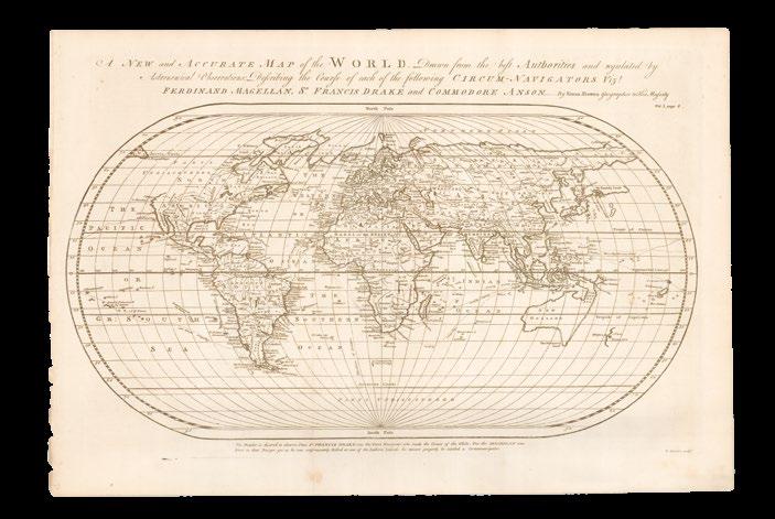
BOWEN, Emanuel; and Thomas KITCHIN
A New and Accurate Map of the World: drawn from the best Authorities and regulated by astronomical observations: describing the course of each of the following circum-navigators vizt. Ferdinand Magellan Sr. Francis Drake, and Commodore Anson.
Publication [London, T. Woodward, A. Ward, S. Birt, 1744].
Description Double-page engraved map.
Dimensions 345 by 587mm (13.5 by 23 inches).
Controversial
Published in the second edition of John Harris’s ‘Navigantium atque Itinerantium Bibliotheca. Or, a Complete Collection of Voyages and Travels’, first published without Bowen’s maps in 1705. The map shows the known world, but assumes an uninterrupted eastern coastline of Australia. A note beneath the map states: “The Reader is desired to observe that Sir Francis Drake was the First Navigator who made the Circuit of the Globe: For tho’ Magellan was First in that Design yet as he was unfortunately Killed at one of the Ladrone Islands, he cannot properly be intitled [sic] a Circumnavigator”.
The mapmakers
Amongst Emanuel Bowen’s first work were maps for George Willdey’s ‘Atlas of the World’ (1717). There followed a period during which he engraved charts for some of the leading hydrographers of his day: Joseph Avery, Samuel Fearon and John Eyes, Nicholas Dobrée, and Murdoch Mackenzie. He also produced a prodigious number of maps for British periodicals. Significant maps that he subsequently published under his own name, include: ‘A new and accurate map of South Wales … delineated from an actual survey and admeasurement by Eman. Bowen’, (1729), a large six-sheet map, sold by subscription, mostly to local wealthy landowners.
In the early 1730s, Bowen took on two apprentices, Thomas Kitchin and Thomas Jefferys, both of whom would become pre-eminent map makers in their own right. There followed some large-scale maps of Norfolk and Huntingdonshire, ‘A new and accurate map of England and Wales’ (1734), maps for John Harris’s ‘Navigantium atque itinerantium bibliotheca’ (1744–8), as well as numerous atlases, including Bowen’s ‘Complete System of Geography’ (1744–7), and ‘Complete Atlas’ (1752).
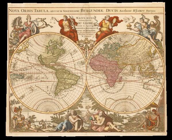
JAILLOT, Alexis-Hubert; Reinier and Joshua OTTENS
Nova Orbis Tabula, ad usum serenissi Burgundiae ducis Mappe monde ou description du globe terrestre & aquatique presentée a Monseigneur Le Duc de Bourgogne.
Publication Amsterdam, Chez R. & I. Ottens, [c1740].
Description Third state. Double-page engraved map, with fine hand colour in full, one or two repaired tears.
Dimensions 491 by 623mm (19.25 by 24.5 inches).
References Shirley, ‘The mapping of the world: early printed world maps, 1472-1700’, 561.
This new map of the world was originally prepared by Jaillot for his ‘Atlas Royale’ which was published by de Fer in 1695 and 1699. The two hemispheres are little changed from those in Jaillot’s larger map of the world (1674) (Shirley 462) but the decorative surround is more detailed and lavish. “Eight large allegorical figures are shown, each with symbols of governance and the arts or, below the hemispheres, against a background representing the four continents. French possessions in Canada are prominently marked ‘Canada ou Nouvelle France’; California remains an island and the coastline of the southern continent is retained. The map is attractively engraved and is much less commonly found than some of the earlier issues of Jaillot’s maps” (Shirley). There are four states of this later map, of which this is the third, with the imprint of the Ottens brothers.
The mapmakers
The Frenchman Alexis-Hubert Jaillot was born in the small hamlet of Avignon in Franche Comte. In 1657 he traveled to Paris with his brother Simon and found employment as a sculptor. He was fortunate to meet the Flemish engraver Nicolas Berey, the publisher and mapmaker to the Queen. His subsequent marriage to Jeanne Berey resulted in Jaillot joining his fatherin-law in trade. Much of Jaillot’s work depended on the maps of his predecessor, Nicolas Sanson d’Abberville (1600-1667), the greatest French map-maker of his generation and the founder of the French School of Geography. The great fire of 1672 destroyed the Blaeu mapmaking empire in Holland and Jaillot quickly acted to fill the gap now left in the market. Near 1670, Sanson’s sons entered into collaboration with Jaillot to produce the monumental ‘Atlas Nouveau’, which included enlarged and embellished renderings of Sanson’s magnificent maps. Jaillot’s efforts awarded him the title of Royal Geographer by Louis XIV.
Joachim Ottens (1663-1719) was a Dutch engraver who established a multi-generational family business. The Ottens firm, founded in 1711, was a publishing and printing business, selling books, maps, and views. His sons, Joshua and Reinier Ottens, continued the firm after their father’s death in 1719, changing its name in 1726 to R & I Ottens. They won great success with their huge and magnificently coloured composite atlases, entitled the ‘Atlas Major’, which were comprised of maps by earlier or contemporary German, French, and Dutch cartographers. Some examples of these volumes, all of which were made to order and tailored to the specific customer’s requests, contain over 800 separately issued maps.
On the death of Reinier I in 1750, his son Reinier II continued his work, but with reversed order of names, as Joshua & Reinier Ottens, until Joshua’s death in 1765. The Ottens family specialized in the reprinting of others’ work, especially Frederick de Wit, Guillaume Delisle, and Nicolaes Visscher.
“Cotes conjectures”
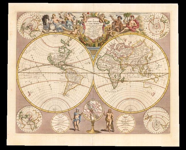
ROBERT DE VAUGONDY, Didier
Mappemonde: ou description du globe terrestre, dressee sur les memoires les plus nouveaux et assujettie aux observations astronomiques, par le Sr. Robert de Vougondy, fils.
Publication
Paris, Chez Les Srs. Robert Geoges. ordes. du Roy, Quay de l’Horloge du Palais, Ante. Boudet Libraire-Imprimr., du Roy, rue St. Jacques. Avec Privilege, 1752.
Description Double-page engraved map, with contemporary hand-colour in full.
Dimensions 465 by 705mm (18.25 by 27.75 inches).
A very attractive example of this double-hemisphere world map, that includes the tracks of the voyages of George Anson and Jean-Baptiste Charles Bouvet de Lozier.
The most obvious feature of the map is the proposal that “cotes conjectures” (Brosses) connect the tip of Cape York peninsula to the southern coast of Tasmania, via, the “Terre du St. Esprit”, which in turn joins up with “Terre of P. Nuyts” in the west. “Terre du St. Esprit” was subsequently revealed to be the islands of Vanuatu, misinterpreted by their explorer Pedro Fernandes de Queirós, in 1606, as part of the mythical great south land.
The mapmaker
The Robert de Vaugondy family of cartographers, particularly Gilles and his son Didier (c1723- 1786), was “securely based on the stock in trade of the great Nicolas Sanson, inherited in 1730 by Didier’s father Gilles” (Swift). The Robert de Vaugondys were descendants of Nicolas Sanson, and their atlas is clearly a continuation of Sanson’s great work, ‘Cartes Generales de Toutes les Parties de Monde’ published in 1654 and later enhanced and enlarged by Hubert Jaillot. The maps of the East Indies, China, Japan; the maps of Africa and Egypt; and the maps of North America, Canada, Virginia & Maryland, Colonies Angloises are especially interesting as they represent the latest exploration.
BOUGAINVILLE, Louis-Antoine de
Voyage autour du monde, par la frégate du Roi La Boudeuse, et La Flûte L’Etoile; en 1766, 1767, 1768 & 1769.
Publication
A Paris, Chez Saillant & Nyon, Libraires, rue Jean-de-Beauvais, 1771.
Description
First edition, first issue. Quarto 265 by 200mm), 20 folding engraved maps and charts, 16 folding and 3 full-page plates; modern calf antique.
References Borba de Moraes, p. 115; Hill I, pp. 31–32; Sabin 6863.
France’s first official circumnavigation of the world – and the naming of a flower
The first French expedition to sail around the world. Bougainville had been sent to hand over control of the Falkland Islands to Spain. “He gives an account of the discovery and occupation of the islands … and a chapter devoted to their natural history … He then proceeded through the Strait of Magellan and across the Pacific to the East Indies and thence home in a three-year voyage that was France’s first official circumnavigation of the world … Bougainville created a great deal of interest among the French in the Pacific, which resulted in the voyages of Nicholas Marion du Fresne and Jean Francois de La Perouse. The largest island in the Solomons and two straits in the Pacific bear his name, and
the tropical flowering vine Bougainvillea was named after him. Later in life, Bougainville took part in the American Revolution and was made a senator and count of the Empire of Napoleon I. This account confirmed Jean Jacques Rousseau’s ‘noble savage’ concept, and inspired Denis Diderot to pen his denunciation of European contact with indigenous peoples” (Hill). Bougainville’s voyage across the Pacific touched at the Tuamotu archipelago and Tahiti (where Ahu-toru, a Tahitian, was taken back to France), before progressing to Samoa, the New Hebrides, the Solomon Islands, and the previously unknown Louisiade Archipelago.
REILLY, Franz Johann Joseph von Karte von der Erde estlicher und westlicher Halbkugel nach D’Anville Neu verzeichnet herausgegeben von Franz Ioh. Ios von Reilly.
Publication Wien, Reilly’sches Landkarten und Kunstwerke Verschleiss Komptoir, 1796.
Description Double-page engraved map, with fine handcolour in full.
Dimensions
400 by 645mm (15.75 by 25.5 inches).
An interesting example of this map, according to Brown, the “only example of which I am aware where the name Ulimaroa is spread right across the Australian continent (with New Holland and New South Wales also shown along the west and east coasts respectively)”. Published in the ‘Grosser Deutscher Atlas’ (1795), the “first Austrian-made complete world atlas” (Rumsey).
“Ulimaroa”, was first used to name Australia, on a map, by Daniel Djurberg in his chart, ‘Karta över Polynesien eller femte delen af jordklotet’ (1780). It may, or may not, depending on which source you read, be derived from a Maori word, “Olhemaroa”, and may mean “Long Hand”, referring to Australia as “Grand Terre”, or “Big Red Land”.... However, earlier in 1776 Djurberg wrote: “the world is divided into 5 main parts: 1. Europe, 2. Asia, 3. Africa, which makes up one large island, 4. America, which makes up the other island, 5. Polynesia, which includes all the large and small islands which cannot be joined to any of the previous four continents and includes, among others, the large island Ulimaroa, which in old geographies is known as New Holland”.
The Mapmaker
Franz Johann Joseph von Reilly (1766-1820) was a prolific cartographer and publisher and, producing maps at a rate of one per week for 17 active years, was responsible for the publication of over 800 maps, and atlases, including his monumental ‘Schauplatz der fünf Theile der Welt’ (17891806), a school atlas (1791-1792), a diplomatic atlas (1791-1798), an atlas of Silesia (1796), the work ‘General Postal Atlas of the Whole World…’ (1799), a ‘Postal Atlas of Hungary…’ (1802) and a ‘Postal Atlas of Italy and Sicily’ (1803).
DUNN, Samuel
A General Map of the World, or Terraqueous Globe: With All the New Discoveries, Containing the most Interesting Particulars in the Solar, Starry and Mundane System. By Sam. Dunn. Mathematician.
Publication London, Laurie & Whittle, May 12th, 1799.
Description Later issue. Wall map of the world on four sheets, joined to make two panels, with contemporary hand-colour in part and in outline.
Dimensions 1038 by 1228mm (40.75 by 48.25 inches).
References Perry & Prescott, ‘A guide to maps of Australia in books published 1780-1830’, 1799.03.
One of the first maps to show Tasmania separated from mainland Australia
Befitting the spirit of scientific inquiry of late eighteenth century England, this magnificent wall map is richly with illustrated with a wealth of information known to scientists in a multitude of disciplines.
The large double-hemispheres at the centre of the map, are surrounded by a dense border crammed with vignette projections of the “... the World according to Mercator’s Projection”, the solar system, latitude and longitude, the seasons, the Analemma, the northern and southern skies, the planets, and a superb depiction of the surface of the moon, after Father Riccoli. All other spare space is covered in didactic text, explaining everything from “Geographical Definitions”, “The Cause of Tides”, “The Art of Dialling by a Common Globe”, and “The Vicissitude of the Seasons explained”. However, “as the Space to which we are here confined for illustrating of this Universal Scale is very small we can only give a few Problems thereon in this Place,...”
The terrestrial hemispheres, reflect the period’s keen interest in grand voyages of discovery. Because of its large-scale format, the tracks of all three of Captain Cook’s voyages, which are also generously annotated, are very clear. The circumnavigations of Bougainville (1766-1769) and Ansen (1741-1744) are shown, and as well as those of other explorers. Alaska, the Pacific Northwest, the South Pacific, New Zealand and Australia were areas receiving important revisions at the time and can be seen on this map to be coming into focus. Laurie & Whittle have made great improvements to the cartography, largely as a result of Cook’s second and third voyages, and Hearne’s explorations in Canada. Australia is named both ‘New Holland’ and ‘Terra Australis’, with new place names noted along the eastern coast, including Port Jackson (now Sydney).
The map was first published in 1772 by Robert Sayer as ‘Scientia Terrarum et Coelorum: or, the Heavens and Earth Astronomically and Geographically Delineated and Display’d…’, and was updated and reissued several times, under the same title in 1781 and 1784, after which the title was changed to the current one, and issued for the first time in 1787.
The mapmaker
Samuel Dunn (died 1794) was a British mathematician and astronomer, and was at the forefront of developments in navigation and cartography over the eighteenth century. He was an authorised signatory for ship’s masters’ certificates, a consultant to the East India Company, and had instruments and publications accepted by the Board of Longitude.
CARY, John
The Western Hemisphere [and] The Eastern Hemisphere.
Publication
London, Printed for J. Cary, Engraver and Map-Seller, No. 181 near Norfolk Street, Strand, Aug.st 1st, 1799 [and] 1801.
Description First issues. Large double-hemisphere map of the world on 2 separate sheets, with contemporary hand-colour in full.
Dimensions 530 by 655mm (20.75 by 25.75 inches).
References Tooley, ‘The Mapping of Australia’, 281.
Attractive examples of the first issue of each hemisphere. Australia is labelled as “New Holland”, and shows “New South Wales Discovered by Capt Cook 1770”. The tracks shown include Cook’s three voyages, La Perouse, and Vancouver. The deaths of Cook and Clerke are noted. Botany Bay and Port Jackson are shown: “M. de la Perouse arrived at Botany Bay Jan 24 1788 and has not been heard of since he left that place”. Van Dieman’s Land (Tasmania) is an island, separated from the mainland by the “Basses Strait”.
The mapmaker
John Cary (1754-1835) was a London based cartographer active in the early part of the nineteenth century. Tooley writes of Cary, “As an engraver he was elegant and exact with fine clear lettering and great delicacy of touch”. Cary began his work as an engraver, cartographer, and globe maker in 1776 with his ‘New and Correct English Atlas’. This important atlas represented a new phase in cartography where accuracy and detail rose in prominence over the decorative embellishments of the 18th century. This change was indicative of the times when travel and commerce were expanding globally as never before. Cary’s mastery of both engraving and cartography resulted in a series of seminal works that redefined mapmaking in the early nineteenth century. His ‘New Universal Atlas’, published in 1808, set the standard for all cartographers who followed. Cary reissued this seminal atlas in 1811, 1819, 1824, 1828, 1833, 1836 and 1844. Cary also did considerable work on the English Ordinance Survey prior to 1805. His cartographic work particularly inspired the Edinburgh school of cartography as represented by John Pinkerton and John Thomson. In America, Cary’s work was used as the basis for Tanner’s important New American Atlas. Cary’s last published atlas appeared posthumously in 1844, however, by 1850 Cary’s work was being carried on by his sons and other well-known cartographers including James Wyld, John Tallis & Company, and Crutchley.
Map of the World showing the extent of the British Empire in 1886.
Publication London, Supplement to ‘The Graphic Magazine’, Maclure & Co. Queen Victoria Street, July 12th, 1886.
Description Large colour printed pictorial map.
Dimensions 585 by 625mm (23 by 24.5 inches).
References Crawford for ODNB online.
“Freedom, Fraternity, Federation”
This Imperial Federation League map was published to coincide with the Colonial and Indian Exhibition of 1886, “a showcase for the wealth and industrial development of the British Empire”, it appeared “just before the Queen’s Golden Jubilee in 1887” and “reflects the celebratory consciousness of Victoria’s Empire” (Biltcliffe).
The realms of the Queen’s Empire are coloured in red, while other geographical areas were left blank with only a minimum number of place names. An inset box was placed near each of the major colonies, listing statistics, supplied by Colomb, about geographical area, population, and trade. The words “Freedom, Fraternity, Federation”, suggesting a peaceful co-existence within the British Empire, were prominently placed along the map’s top margin, but the remainder of the map’s illustrations distinctly imply “colonialism”. At the bottom centre Britannia is seated on top of the world ruling over her subjects, represented by a variety of animals and costumed figures. India, identified by an elephant and a tiger, appears in the lower left corner, while Australia, including a kangaroo and a sheep, is shown in the lower right.
To the upper right is an inset map depicting Britain’s colonial possessions one hundred years earlier in 1786.
The illustrations were drawn by Walter Crane, a prominent illustrator and artist with strong socialist sympathies, perhaps explaining the contradictory themes in the map of imperialism and “human labour” holding up the world in the form of Atlas. Crane’s contributions to the map remained unnoticed until the research of Pippa Biltcliffe was published in 2005.
The mapmaker
Walter Crane (1845-1915), is probably best known as a well-loved illustrator of children’s books. Between 1865 and 1875 Crane illustrated thirty-seven of these ‘Toy Books’ for Edmund Evans and Routledge.
“In 1884, after some friendly argument with William Morris, Crane became a socialist. He joined the Social Democratic Federation along with Morris, and as Morris changed allegiance Crane followed, joining the Socialist League later in 1884 and the Hammersmith Socialist Society in 1890. This was more a matter of personal loyalty than of shared beliefs, for the sources of Crane’s socialism were different from Morris’s: the radicalism of his master W. J. Linton, the positivist belief in progress, memories of the Paris commune of 1871. He became the artist of the cause, designing posters, trade-union banners, cartoons, and newspaper headings, adapting the emblematic figures of his paintings to socialist themes. His ‘The Triumph of Labour’, drawn for May day 1891 and reproduced in ‘Crane’s Cartoons for the Cause, 1886–1896’ (1896), is a Renaissance-style triumphal procession rendered in the gritty texture of wood-engraving and filled with sturdy workers, bullock carts, and banners. Morris said it was the best thing he had ever done” (Crawford).
Bondi Pier I was down by Bondi Pier, Drinkin’ tubes of ice cold beer, With a bucket full of prawns upon my knee, When I swallowed the last prawn, I had a technicolor yawn and I chundered in the old Pacific Sea.
(Sir Les Patterson)
METELLUS, Johannes Matalius
Chica Sive Patagonica et Australis Terra.
Publication [Cologne, Excudebat Stephanus Hemmerden typographus, anno à partu Virgineo MDC], 1598 [but 1600].
Description
Double-page engraved map, with fine handcolour in full.
The first regional map of the “great south land” (Clancy)
Two maps on one sheet: the upper section shows the Straits of Magellan; the lower, the unknown part of “Terra Australis” on a polar projection. Published in Metellus’s ‘America, sive novus orbis, tabulis Aeneis secundum rationes geographicas delineatus’ (1600).
More finely engraved, and also more scarce, but nevertheless based on Wytfliet’s map of the same title, published in ‘Descriptionis Ptolemaicae Augmentum’ (1598) which was, as the title suggests, marketed as a supplement to Ptolemy’s ‘Geographia’.
The first regional map of the “great south land”. Divided into two compartments “the upper shows Patagonia and below a large continent Australis Terre Pars. The lower and larger compartment shows in a threequarter hemisphere, Terra Incognita Terra Australis with a decorated title-piece on righthand side. It depicts a large Terra Australis separated from New Guinea by a narrow strait, shows Beach, Lucach and Maletur below Java and Psittacorum Regio below the Cape” (Tooley).
“There are few more important stretches of water in relation to Antarctic discovery than the Magellan Straits, the 350-mile navigable passage separating Patagonia from Tierra del Fuego or, as thought for nearly 100 years, Terra Australis” (Clancy).
The mapmaker
Johannes Matalias Metellus (1520–1597), Metellus is known to have contributed material to a new edition of Ortelius’s ‘Theatrum’ in 1575, passed information to Gerard Mercator in 1577 concerning an expedition in Mexico and the spice trade in the East Indies, and he is thanked in the introduction to Michael von Aitzing’s ‘Leo Belgicus’. He also wrote the description of Lyon in the first volume of Braun and Hogenburg’s ‘Civitatis Orbis Terrarum’, and a preface to volume two of the same work. Whilst Metellus appears to have been of assistance to others, he was not, it would seem, particularly successful in getting his own output into print. The surviving works suggest that he planned ultimately to publish a small-format multivolume world atlas, starting with France, Austria, and Switzerland (Meurer, MET1), and Spain (Meurer, MET2), although both of these were published anonymously.
Metellus’s cartography is distinctive from the atlases produced in the Low Countries in the same period in that it borrows heavily from the Italian cartographic tradition of the so-called “Lafreri School”.
ORTELIUS, Abraham
Maris Pacifici, (quod vulgo Mar del Zur). Cum regionibus circumiacentibus, insulisque in eodem passim sparsis, novissima description.
Publication
Antwerp, Jan Baptist Vrients, 1609.
Description
First state. Double-page engraved map, with contemporary hand-colour in full, Latin text on verso.
Dimensions
346 by 499mm (13.5 by 19.75 inches).
References
Burden, ‘The Mapping of North America’, 74; Clancy, ‘So Came They South’, page 48; Clancy, ‘The Mapping of Terra Australis’, 5.6; Suarez, ‘Early Mapping of the Pacific’, 65; Suarez, ‘Shedding the Veil’, plate XV; Van den Broecke, ‘Ortelius Atlas Maps: An Illustrated Guide’, 12.1 1609L6.
“A very new description of the peaceful sea, commonly called South Sea with the regions lying around it, and its islands, scattered everywhere” (Ortelius)
This, the first printed map to focus on the Pacific Ocean, is the “most important sixteenth-century cartographic statement of the considerable Spanish contribution to exploration of the southern seas. Following the initial circumnavigation in 1519-22 by Magellan’s ship ‘Victoria’, Spaniards such as Mendana and Quiros sought the east coast of Terra Australis” (Clancy).
Indeed, the ‘Victoria’ features large in this beautiful map, and she has something to say, which appears in a caption beneath her portrait: “Prima ego velivovis ambivi cursibus Orbem, Magellane novo te duce ducta freto. Ambivi, meritoque vocor VICTORIA: sunt mî Vela, alæ; precium, gloria: pugna mare” - I was the first to sail around the world by means of sails, and carried you, Magellan, leader, first through the straits. I sailed around the world, therefore I am justly called Victoria (Victory), my sails were my wings, my prize was glory, my fight was with the sea.
As with his map of the Americas, Ortelius has ostentatiously signed his name to it, in a magnificent dedicatory cartouche to the honourable Lord Nicolaus Roccoxius, patrician of Antwerp, and senator of that city, lower left: “Abrahamus Ortelius Regiæ Mts. geographus sub. merito dedicabat. 1589” - Abraham Ortelius, geographer of his royal Majesty because of merit, has dedicated [this map] in 1589”. And proclaimed his privilege to publish it for ten years, lower right: “Cum privilegiis Imp. & Reg. Maiestatum, nec non Cancellariæ Brabantiæ, ad decennium” - with privileges of the imperial and royal Majesties, as well as of the Brabant council, for a period of ten years.
This is only the third map that Ortelius would inscribe in such a way. “Ortelius took pride in the practice of crediting his maps’ authors, whose names often appear in the dedicating cartouche. But here he credits only himself. The map is probably his own composite of data from various sources. Additional fuel to the mystery surrounding this map lies in its depiction of New Guinea. Although New Guinea had been discovered possibly as early as 1511, the question of whether it was an island or part of Terra Australis remained unanswered until Torres’s incredible voyage of 1605. As his discovery was concealed and officially forgotten, it remained an enigma until the first voyage of James Cook” (Suarez).
The present example is the first state of the map, first published by Christopher Plantin in 1589.
Ortelius’s ‘Theatrum Orbis Terrarum’ is widely regarded as the first modern atlas. At the time of its publication, it was the most expensive book ever produced. Between 1570 and 1612, it was issued in 31 editions and seven languages.
HONDIUS, Henricus
Polus Antarcticus Henricus Hondius excudit.
Publication Amsterdam, Henricus Hondius, 1637.
Description First state. Engraved map, with contemporary hand-colour in full, Latin text on verso.
Dimensions 440 by 498mm (17.25 by 19.5 inches).
References Clancy, ‘Mapping Antarctica’, 10.3; Clancy, ‘So Came They South’, 6.8; Clancy, ‘The Mapping of Terra Australis’, 6.8; Spence, ‘Antarctic Miscellany’, 3013; Tooley, ‘The Mapping of Australia’, 727; see Tooley, ‘Early Antarctica’, 20 (later state).
The first state of the first map to be to be “devoted exclusively to the [south] Polar Regions” (Tooley)
Hondius’s circular map of the Southern Hemisphere showing parts of South America, Africa and southern Australia along with the supposed coastline of the unknown southern continent. Predating the first appearance of New Zealand and Van Dieman’s Land. The detail around Western Australia shows t’ Lant van P. Nuyts discovered in January 1627, Edel’s Lant discovered in 1619, Eendrachts discoveries in 1616, as well as notes mentioning Williams Renier and Dirck Hertogs Ree, and several other place names and early contacts prior to the discoveries of Tasman in 1642 and 1643-44.
‘Polus Antarcticus’ was first issued in 1637 by Dutch cartographer and engraver Henricus Hondius, with Dutch text on verso. The map is bordered by elaborate representations of native figures, sailing ships, penguins and “sea lions” frolicking in the water, and is before the addition of New Zealand and Tasmania, but showing the discoveries of Hartog in the Eendracht (1616), Houtman with the Dordrecht and Amsterdam (1619), the Leeuwin (1622), Nuyts in the Gulden Zeepaard (1627) and de Witt in the Vianen (1628).
The “first map to be devoted exclusively to the [south] Polar Regions and named as such is the Polus Antarcticus of H. Hondius. It depicts a string of islands in a practically straight line, north and south, from Magellanica to New Guinea with a hypothetical wavy line curving round towards the coast of West Australia. The map of Hondius was reissued by Janson at various dates and again as late as 1700 by Peter Schenk, thus having an effective life of over 50 years” (Tooley).
The mapmakers
Faced with increasing competition from the large cartographic house of Blaeu, Johannes Janssonius and his business partner Henricus Hondius set about revising the Mercator – Hondius atlas. After Jodocus Hondius I’s death in 1612, his widow, Jodocus Hondius II and his brother, Henricus Hondius II (1597–1651), had continued publishing atlases under his name until 1620. Unfortunately, in 1621 Jodocus Hondius II split with his brother, creating a rival publishing house. Henricus continued his father’s business with his brother-in-law, Joannes Janssonius (1588–1664), who had married twenty-four-year-old Elizabeth Hondius in 1612. After 1619, the ‘Atlas’ was published under the name of Henricus Hondius, Jodocus Hondius’s son, but by 1629, the Blaeu family were becoming serious rivals to the publishing partnership of Janssonius and Hondius.
First state. Double-page engraved chart, with contemporary hand-colour in outline and in part, French text to verso.
Dimensions 448 by 548mm (17.75 by 21.5 inches).
References
Burden, ‘The Mapping of North America’, 292; Clancy, ‘The Mapping of Terra Australis’, 6.16.
The first chart of the Pacific region in a Dutch atlas
Johannes Janssonius’s chart of the Pacific Ocean was the first included in a Dutch atlas, his ‘Atlas Novus’ of 1650. It includes some interesting myths: a chain of islands across the centre of the map, a remnant of Gerard Mercator’s concept of “Terra Australis”; a large landmass labeled “Terra Incognita” along the top; and California is an island. The coastline of Australia extends to only the discoveries of Willem Janszoon’s voyage in the ‘Duyfken’ (1606) down the south coast of New Guinea and along the west coast of the Cape York peninsula, adding the discoveries of Jan Carstensz in command of the ‘Pera’ during his voyage of 1623, which followed the route of the ‘Duyfken’, and continued into the Gulf of Carpentaria.
The mapmaker
The son of an established printer — publisher Jan Jansz., Johannes Janssonius (1588-1664), was Willem Jansz. Blaeu’s main rival. In 1618, he set up his own cartographic publishing firm on the Damrak, the central canal and commercial hub of Amsterdam. In 1612, he married Elisabeth de Hondt, the daughter of Jodocus Hondius,… another of Blaeu’s competitors. “Theirs was a rivalry which soon grew to include accusations of plagiarism and theft of intellectual property, a state of affairs not helped by Blaeu’s use of the name “Jan Zoon” to sign his works” (Woods).
Although Janssonius’s first independent work was an edition of Blaeu’s ‘Licht der Zeervaert’ in 1620, he is first associated with the Mercator-Hondius atlas in 1633, when the French edition includes his name on the title-page. The Dutch editions of 1634, 1638 and 1647 were published by Janssonius alone; but the English edition, 1636, the Latin of 1638, were issued by both Janssonius and Hondius. After 1638 the name of the atlas changed to ‘Atlas Novus…’, and from 1649 Hondius’s name no longer appears on the title-page or preface. In time, Janssonius would add a fifth volume, the ‘Atlas Maritimus’ (1657), a significant sea-atlas; and eventually, a further five volumes including maps from every corner of the globe, by about one hundred credited authors and engravers. The final, eleventh volume, Andreas Cellarius’s celestial atlas, completed the ‘Atlas Major’ in 1660.
THEVENOT, Melchisedec; and Abel Janszoon TASMAN
Relations de Divers Voyages Curieux qui n’ont point esté publiées, ou qui ont esté traduites d’Hacluyt, de Purchas et d’autres voyages Anglais, Hollandais, Portugais, Allemands, Espagnols, et de quelques Persans, Arabes et auteurs orientaux.
Publication
Paris, Jacques Langlois, chez G. Meturas, S. Piget, E. Langlois, T. Joly & L. Billaine 1663.
Description
First edition, first part only, Folio (360 by 230mm). (4)ff, XXVpp., 52pp., 50pp. (poorly numbered, but complete), 12pp., 80pp., 30pp., 19p. (poorly numbered, but complete), 35pp., 56pp (poorly numbered, but complete), 9pp., (2)pp., numerous pages misnumbered, but complete, four engraved plates (two double-page), four illustrations in the text, and four engraved maps,; contemporary mottled calf, rebacked, spine in 7 compartments with red morocco lettering piece, gilt, in the second.
References
Tooley, ‘The Mapping of Australia’, 1247.
Thevenot’s Voyages
A rare first edition, of the first part of the first volume, with the map of Australia in the first state: one of the earliest printed maps of the country.
The first three volumes were published between 1663 and 1666. A fourth part was published in 1672, and a fifth part unfinished in 1696. “It is difficult to find complete copies” Brunet (V, 810-813), because each volume is composed of separate parts. Brunet adds that “no two examples have the same parts in the same order”.
The text is based on the original manuscripts collected by Melchisedec Thevenot, Orientalist and librarian to the King, and offers much good information on the Dutch East India Company (V.O.C.), Eastern alphabets, one of the first representations of cuneiform characters, etc.
The mapmakers
Abel Jansz. Tasman (c1603-1659), was the first European explorer to reach and map the coastlines of Tasmania and New Zealand. After a series of shipwrecks had revealed some of the western coast of Australia, he was chosen by Anthony van Diemen, Governor-General of the Dutch East Indies, to lead a voyage of discovery to the south, in 1642. The intention was to find a sea route south of Nuyts land, and east across the Pacific to South America. In his ships, the ‘Heemskerck’ and ‘Zeehaen’, over a course of ten months, Tasman mapped the coast of southwest Tasmania, the west coast of New Zealand, and the island groups of Tonga and New Guinea. A second voyage, in 1644, Tasman and crew surveyed the southwest coast of New Guinea, and much of Australia’s northern coastline, as here.
Although the longed for southern sea route was not found,… the easterly’s were too strong, Tasman was awarded the rank of commandeur on his return, and a pay rise was backdated to the beginning of his first voyage. Subsequently, Tasman was “appointed to the Council of Justice at Batavia. In mid-1647 he was sent on a mission to the King of Siam and was granted precedence over all Dutchmen in the kingdom. After that mission, he was given command of a fleet of eight vessels which sailed in May 1648 against the Spaniards. His conduct in this operation was unsatisfactory and, after his return in January 1649, proceedings were taken against him for having, when inflamed by liquor, treated one of his sailors in a barbarous way; as a result, he was removed from office during the governor-general’s pleasure. He was formally reinstated in January 1651, but not long afterwards retired from the service and became a merchant in Batavia. He died there in affluent circumstances in 1659” (Forsyth).
Melchisedech Thevenot (1620-1692) was a French diplomat, scientist, and travel writer. He was a scholar with interests in mathematics, physics, and medicine, acting as the patron of several early scientific societies and most notably contributing to the formation of the Academie des Sciences. His early career included two missions to Italy in the 1640s and 1650s, and it was there that he first developed an interest in the study of Oriental languages. In 1663, he published the first part of his ‘Relations de Divers Voyages’, a work that would secure his reputation as one of the most important travel compilers of the seventeenth century. He would go on to publish a second and third part in 1666, a fourth in 1672, and a final fifth part was being assembled in 1692 when Thevenot died.
KEULEN, Johannes van
Pascaert vande Zuyd Zee en een gedeelte van Brasil van Ilhas de Ladronos tot R. de la Plata.
Publication
Amsterdam, Ioannes van Keulen aen de Nieuwe brugh in de Gekroonde Lootsman, Met Priviligie vor 15 yaar, [1680].
Description
Second issue. Double-page engraved chart, with contemporary hand-colour in outline.
Dimensions 511 by 595mm (20 by 23.5 inches).
References
Clancy, ‘The Mapping of Terra Australis’, 7.4; McLaughlin, ‘The Mapping of California as an Island’; Suarez, ‘Early Mapping of the Pacific’, 88; Tooley, ‘The Mapping of Australia’, 796.
Visualising ousting Spain from the Pacific
The cartouche at the centre of this chart says it all. An allegorical scene shows the Dutch and the British liberating the lands of the Pacific arena, including rather ambitiously, the Americas, which take up nearly the whole of the eastern half of the chart, from the Spanish. To make the point further, the chart is filled with galleons firing canon at each other.
At the time the Van Keulen family published this chart, Spain controlled the Philippines (1565–1898); Palau (1574–1899); the Marianas (1667–1898 or 1899); and had their sights set on the Carolines (1686–1899). Together with the Spanish West Indies, these islands were administered through the Viceroyalty of New Spain based in Mexico City.
The Treaty of Tordesillas (1494) had established a line of demarcation at 370 leagues west of the Cape Verde Islands, carving the world in two between Spain and Portugal, pole to pole. Spain had gained everything to the west, which was most of the Americas, except for the Brazilian bulge of South America (omitted from this chart); and Portugal, could claim lands to the east, including Africa…
BUT,… where should the territories meet on the other side of the earth?
Charles V of Spain had a good idea: he married Isabella of Portugal in 1526, and signed a new treaty with Portugal, creating an antimerdianal line, in Zaragoza in 1529. Portugal “paid Spain 350,000 ducats for the Moluccas, and, to prevent further Spanish encroachment, the new line of demarcation was established almost three hundred leagues (or 17°) to the east of these islands. Portugal got control of all of the lands to the west of the line, including Asia, and Spain received most of the Pacific Ocean. Spain’s argument that the Treaty of Tordesillas divided the world into two equal hemispheres was not recognized in the Treaty of Saragossa: Portugal’s share was approximately 191°, whereas Spain’s was roughly 169°, with a variation of about ±4° owing to the uncertainty of the location of the Tordesillas line. Spanish interest in the Philippines, shown by the new treaty to be on the Portugal side of the line, would become an issue in the later decades of the sixteenth century” (Princeton University online).
Second issue, with “Compagnies Land” added upper left.
The mapmaker
Johannes van Keulen (1654-1715) established a bookselling and instrument making business in Amsterdam in 1678, and by 1680 he had obtained a privilege from Holland and West Friesland to print pilot guides and sea atlases. His first major production was the atlas ‘Nieuwe Lichtende ZeeFakkel’, illustrated by Jan Luyken and with maps by Claes Jansz Vooght. Five volumes were published between 1681 and 1684.
CORONELLI, Vincenzo Maria
Mare del Sud, detto altrimenti Mare Pacifico. Auctore, Il P.M. Coronelli M.C. Cosmografo della Serenissima Republica Divenetia dedicato All’ Ill.mo et Ecc.mo Signor, Il Signor Cavalier Giulio Giustinian Sauio Grande.
Publication Venice, Girolamo Albrizzi, 1696.
Description Double-page engraved map.
Dimensions 452 by 605mm (17.75 by 23.75 inches).
References Clancy, ‘The Mapping of Terra Australis’, 6.20; Saurez, ‘Early Mapping of the Pacific’, 90; Tooley, ‘The Mapping of Australia’, 350.
Coronelli’s map of the Pacific
Published in Vincenzo Maria Coronelli’s magnificent atlas ‘Atlante Veneto’ (1696).
Coronelli’s detailed chart of the Pacific Ocean, illustrates the route of the voyage of Jacob Le Maire (1615-1616) around Tierra del Fuego to the East Indies. Although, Le Maire’s voyages gave decisive evidence against the supposed existence of a massive southern continent, Coronelli persists in showing a hazy diagonal line across the lower half of the chart, a remnant of the mythical island chain of Johannes Janssonius’s chart of 1650, labelled, “Piaggie non per anco conosciute” – beaches not yet known.
However, the coastline of Australia is accurate for the time, extending to include the discoveries of Willem Janszoon’s voyage in the ‘Duyfken’ (1606) down the south coast of New Guinea and along the west coast of the Cape York peninsula; adding the discoveries of Jan Carstensz in command of the ‘Pera’ during his voyage of 1623, which followed the route of the ‘Duyfken’, and continued into the Gulf of Carpentaria; as well as including some of the discoveries of Abel Tasman in 1642 and 1644 of the coastlines of New Zealand and Tasmania.
The mapmaker
Vincenzo Coronelli (1650-1718) was an Italian cartographer and globe maker. He was apprenticed to a woodcut printer at ten years old, but then entered the Franciscan Order as a novice at thirteen.
In 1701, he was made Father General of the Order, but was removed from office by the Pope three years later after complaints from fellow clerics. Coronelli mainly lived and worked in Venice, but an opportunity arose to make his name when an early commission for two globes for the Duke of Parma brought him to the attention of the Cardinal d’Estrées, who summoned him to Paris to create two huge globes for Louis XIV. They each had a diameter of fifteen feet, and were built with trapdoors so they could be worked on from the inside. He was made royal cartographer to Louis XIV in 1681 as a result, and worked in Paris for two years. He collaborated with Jean Baptiste Nolin, who went on to become the French publisher for all of Coronelli’s work.
On his return to Venice, Coronelli was made cosmographer to the Republic, and granted a stipend of 400 florins a year. He printed globe gores in the ‘Libri dei Globii’ as well as producing pocket globes, and his large globe over a metre in diameter was owned by royalty across Europe. He issued the ‘Atlante Veneto’ in 1691, which was intended to be an extension of Blaeu’s atlas in three parts, covering hydrography and ancient and modern geography. One of the volumes was an isolario.
KEULEN, Gerard van
[Untitled chart of the Pacific Ocean].
Publication
t’ Amsterdam, Par Gerad van Keulen aen de Nieuwe brug Met Priviligie, [before 1726].
Description Fourth issue. Double-page engraved chart, with contemporary hand-colour in outline.
Dimensions 511 by 595mm (20 by 23.5 inches).
References Tooley, ‘The Mapping of Australia’, 797.
Final state
In this the final state of the van Keulen family map of the Pacific Ocean, previously issued under the title ‘Pascaert vande Zuyd Zee en een gedeelte van Brazil’, Carpentaria island, and several other smaller ones, appear. “Simon Dewez speculated that the apparently retrograde step of the Carpentaria island comes from the confusion of the time on the east coast of Australia. By 1730 some French mapmakers had linked Cape York to the New Hebrides and thence Tasmania. Perhaps being more careful, van Keulen thought the New Hebrides were close enough to be joined to Cape York, but not Tasmania(!)” (Brown).
The mapmaker
The van Keulen cartographic dynasty continued for nearly two centuries. Johannes van Keulen (1654-1715) had established a bookselling and instrument making business in Amsterdam in 1678, and his son, Gerard (1678–1726), produced new editions of his father’s works and made numerous manuscript charts. He was appointed hydrographer to the Dutch East India Company (VOC) in 1706. Johannes’s grandson, Jan II van Keulen (1704–1770) took over the business in 1726, and published a new edition of the Asian volume of the ‘Zee-Atlas’. He was appointed chartmaker to the VOC in 1743, setting an official seal on a well-established relationship that was to last until the company dissolved in 1799.
BROSSES, Charles de
Histoire des navigations aux Terres Australes.
Publication Paris, Chez Durand, 1756.
Description
First edition. 2 volumes. Quarto (250 by 195mm), title, xiv, 463pp., 4pp. errata, title, 514pp., 2p. errata, seven folding engraved maps, contemporary full mottled calf, gilt.
References Hill, ‘The Hill Collection of Pacific Voyages’, 190.
Encouraging
With the important ‘Sur les decouvertes des Hollandais dans l’Australaisie’, found between pages 437* and 450* towards the end of Volume I.
“An extremely important and thorough collection of voyages, and one of the outstanding works relating to the early history of Australasia” (Hill). It contains an account of all voyages to the south, beginning with the second Vespucci expedition of 1502, and going up to 1747, including the voyages of Magellan, Drake, Quiros, Schouten, Le Maire, Tasman and others.
De Brosses profoundly influenced Bougainvile, and sought to encourage French discovery in the South Seas, and also argued for programmatic colonisation. He suggest France should colonise Australia.
De Brosses’s text was later used by John Callander as the (unacknowledged) basis for his influential ‘Terra Australis Incognita’ (1766-1768) in which form it had much to do with British plans for colonial expansion by transportation.
Provenance
With the ink de-accession stamps from the K.k. Marine Ober-Com. Bibliothek on each title-page.
CALLANDER, John; and Didier ROBERT DE VAUGONDY
Terra Australis Cognita: or voyages to the southern hemisphere, during the sixteenth, seventeenth, and eighteenth centuries. Containing an Account of the Manners of the People, and the Productions of the Countries, hitherto found in the Southern Latitudes; the Adventures that may result from further Discoveries on this Great Continent, and the Methods of establishing Colonies there, to the advantage of Great Britain. With a Preface by the Editor, in which some geographical, nautical and commercial Questions are discussed.
Publication
Edinburgh, Printed for the Author; and sold by Messrs Hawes, Clark and Collins, in Pater-noster-Row, 1766-1768.
Description
First edition, first issue. 3 volumes. Octavo (200 by 120mm), 3 folding engraved charts, early ownership inscription on title-page; contemporary tan calf, rebacked preserving the original spines.
References
Davidson, ‘A Book Collector’s Notes on items relating to the Discovery of Australia, The First Settlement and the Early Coastal Exploration of the Continent’, page 35; ‘ Hill, ‘The Hill Collection of Pacific Voyages’, 240.
A serious proposal…
The exceptionally rare first issue, with the dedication leaf to Charles Townsend (“To the Reader” on the verso), and three large charts by Thomas Phinn after Dider Robert de Vaugondy. That of Australia being “of great interest, particularly when compared with the Tasman map of 1644. Although Van Diemen’s Land is still shown as part of the mainland, New Zealand and New Guinea are already known to be separate lands and in fact the outline of Australia is complete except for the eastern coast, yet to be charted by Cook...” (Davidson).
Callander based his work on de Brosses’s, ‘Histoire des Navigations aux Terres Australe’ (1756), and his chapter ‘Of the method of forming colonies in the Terra Australis, and the Advantages that may be expected to result to Great Britain from such Establishments in that Hemisphere’ gave credence to “a serious proposal to establish a British penal settlement in the South Pacific, which is printed at the end of Volume III. It was seen as a basis for further exploration in New Holland, and significantly influenced British thinking” (Brown).
There are sixty-three voyages included in the work, extending from Vespucci, to Pelsaert, to Tasman, to Vlamingh, Anson, and Byron.
DALRYMPLE, Alexander
An Historical Collection of the Several Voyages and Discoveries in the South Pacific Ocean.
Publication
London, Printed for the Author and sold by J. Nourse and T. Payne, 1770-1771.
Description
Second issue. 2 volumes in one. Quarto (275 by 215mm). 4 folding engraved charts, 4 folding plates, 8 full-page plates; modern half red morocco, gilt.
In which the only name missing from the list, was the author’s own…
Preceded by an exceptionally rare first issue with the title-page of the first volume dated 1769, known in only a handful of examples. Dalrymple’s collection “was the sum of knowledge before Cook, and was in the course of publication when Cook returned. He was driven by belief in a greater southern continent and virulent antagonism to virtually every British navigator of the time, especially Cook. The long introduction argues the theoretical case for the existence of a southern land mass to counterpoise the mass of Europe and Asia, and he selects texts to support his theory. Cook’s second voyage was largely despatched to settle once and for all the issues raised so insistently by Dalrymple” (Brown).
In fact, Dalrymple had been passed over for James Cook to lead the 1768 transit of Venus expedition and subsequent search for Terra Australis, and in 1767 had published ‘An Account of the Discoveries Made in the South Pacifick Ocean Previous to 1764’, in part to support his own case to lead the expedition.
The mapmaker
The first hydrographer to the British Admiralty, Alexander Dalrymple (1737-1808) is best known for his researches regarding a great Southern Continent, as well as a proponent of the search for the Northwest Passage (thereby influencing Vancouver’s survey). Through family connections, Dalrymple was made a “writer” (the most junior position) for the East India Company and sent to Madras where he arrived in May 1753. He was afforded access to Robert Orme’s library and grew increasingly fascinated with the EIC’s activities in Burma, Indo-China and Borneo. He turned down a promotion so that he might undertake a voyage to the east of his own. “In February 1759, Pigot freighted the Cuddalore (Captain George Baker) for Dalrymple ‘to attempt to discover a new route to China through the Molucca Islands and New Guinea’. Dalrymple made three voyages between 1759 and 1764 to the Philippines, Borneo, and Sulu. In the first, based at Canton (Guangzhou), he reconnoitred Borneo, the Philippines, and the coast of Cochin-China. For the second, in the London in 1762, he had James Rennell as companion for a voyage to Sulu and Balambangan, where he had obtained for the company a grant of land. In Madras in 1763 he went through the formality of resignation, confident of reinstatement, to return to London to promote a trading settlement at Balambangan. En route to Canton for passage to England he became provisional deputy governor at Manila for a short period in April 1764, in the aftermath of the treaty of Paris, and he arrived in London in the summer of 1765 …” (ODNB)
BOUGAINVILLE, Louis-Antoine de
A Voyage Round the World
Performed by Order of His Most Christian Majesty, In the Years 1766, 1767, 1768, and 1769.
Publication London J. Nourse and T. Davies, 1772.
Description
First edition in English. Octavo (210 by 270mm), 5 folding engraved maps, and one folding plate; contemporary full tan calf, gilt, repaired at the head and foot of the spine.
References Hill, ‘The Hill Collection of Pacific Voyages’, 165.
France’s first official circumnavigation of the world – and the naming of a flower
The first French expedition to sail around the world. Bougainville had been sent to hand over control of the Falkland Islands to Spain. “He gives an account of the discovery and occupation of the islands … and a chapter devoted to their natural history … He then proceeded through the Strait of Magellan and across the Pacific to the East Indies and thence home in a three-year voyage that was France’s first official circumnavigation of the world … Bougainville created a great deal of interest among the French in the Pacific, which resulted in the voyages of Nicholas Marion du Fresne and Jean Francois de La Perouse. The largest island in the Solomons and two straits in the Pacific bear his name, and the tropical flowering vine Bougainvillea was named after him. Later in life,
Bougainville took part in the American Revolution and was made a senator and count of the Empire of Napoleon I. This account confirmed Jean Jacques Rousseau’s ‘noble savage’ concept, and inspired Denis Diderot to pen his denunciation of European contact with indigenous peoples” (Hill).
Bougainville’s voyage across the Pacific touched at the Tuamotu archipelago and Tahiti (where Ahu-toru, a Tahitian, was taken back to France), before progressing to Samoa, the New Hebrides, the Solomon Islands, and the previously unknown Louisiade Archipelago.
Provenance
With engraved armorial bookplate of Samuel Reynolds Solly.
“Kangaroo” in print for the first time
PARKINSON, Sydney
A Journal of a Voyage to the South Seas in his Majesty’s Ship, The Endeavour. Faithfully transcribed from the Papers of the late Sydney Parkinson, Draughtsman to Joseph Banks, Esq. on his late Expedition, with Dr Solander, round the World. Embellished with Views and Designs, delineated by the Author, and engraved by capital Artists.
Publication
London, Printed for Stanfield Parkinson, the Editor:... MDCCLXXXIII 1773.
Description
First edition. Quarto (350 by 265mm), engraved frontispiece portrait, double-page engraved map, and 27 numbered plates, including a map; contemporary tree calf, gilt, hinges split.
References Hill, ‘The Hill Collection of Pacific Voyages’, 1308.
As a young man, Sydney Parkinson left his native Edinburgh to seek his fortune in London. There he came within the orbit of Joseph Banks, who chose him to be one of his select “scientific gentlemen”, as botanical draughtsman, to accompany him and James Cook on a voyage to the South Seas in HMB ‘Endeavour’. During the voyage Parkinson made more than 1000 drawings. Sadly, on the return journey, when the ‘Endeavour’ disembarked at Batavia in 1771 for repairs, Parkinson was one of many who contracted dysentery and died at sea.
In England “later that year a dispute arose between Banks and Parkinson’s brother, Stanfield. Banks had paid the latter £500 for balance of salary due and for Parkinson’s papers and drawings. The papers were later lent to Stanfield Parkinson, who contrary to agreement had them transcribed for publication and was restrained by an injunction from doing so until the official account of the voyage had appeared. His book was published later in the same year, 1773 [as here], entitled ‘A Journal of a Voyage to the South Seas’, with a second enlarged edition in 1784. A result of the squabble was that although Hawkesworth, who edited the official account of the voyage, used Parkinson’s papers and drawings freely he did not acknowledge them. Only two of Parkinson’s illustrations in these books are of Australian subjects. His own contains a study of the two Aboriginals who opposed Cook at Botany Bay, and Hawkesworth has a view of the Endeavour River (Cooktown, Queensland). A third of a kangaroo, formerly attributed to Parkinson, is now known to have been from a painting by George Stubbs. Parkinson was the first European artist to set foot on Australian soil, to draw an authentic Australian landscape, and to portray Aboriginals from direct observation. A great quantity of his work survives” (Rienits for ADB online).
Provenance
The Robert and Mary Anne Parks collection, Hordern House 2007.
COOK, Captain James R.N., F.R.S. HAWKSWORTH, John; and James KING
[Complete Set of the Official Accounts of His Three Voyages Round the World]. An Account of the Voyages Undertaken by the Order of his Present Majesty for Making Discoveries in the Southern Hemisphere..;
A Voyage towards the South Pole, and Round the World..; A Voyage to the Pacific Ocean...
Publication [London, [1773 -1785].
Description
Second, third, and second editions, respectively. 8 quarto volumes, of text (first and second voyages: 290 by 230mm), (third voyage: 235 by 300mm), 3 folio atlases, (1st voyage: 455 by 280mm), (second voyage: 480 by 310mm), (third voyage: 545 by 400mm); 180 charts and plates, including Bartolozzi and Byrne’s ‘The Death of Captain Cook’ (1785); uniformly (not identically) bound in full eighteenth century tree calf, spines elaborately gilt, with double red and green lettering-pieces.
References
Beddie, ‘Bibliography of Captain James Cook’, 650, 126, 1552; Hill, ‘The Hill Collection of Pacific Voyages’, 783, 358, 361.
Set of Cook’s three voyages, with the plates and maps bound separately in three atlas volumes
An excellent set of Cook’s three voyages with three separate atlases.
Cook (1728-1779) was promoted to the rank of Lieutenant and despatched by the Admiralty at the insistence of the Royal Society to observe the 1769 transit of Venus across the face of the sun and to seek out the much discussed southern continent. Accompanying Cook were Joseph Banks (from the Royal Society), the Swedish naturalist Dr. Daniel Carl Solander and the artist Sydney Parkinson. Sailing via Madeira and Tierra del Fuego Tahiti was reached in April 1769 where the transit was successfully recorded in June of that year. From Tahiti Cook sailed to the South Pacific in search of the new continent, first striking the Society Islands, before reaching New Zealand, whose coast he surveyed. From thence Cook proceeded to New Holland surveying the whole East Coast, before returning home via Batavia, proving once and for all the New Guinea was not a part of Australia, a fact first shown by Torres in 1607. He finally reached England in 1771, anchoring off the Downs on 12th June, having lost one third of his crew.
In July of the following year Cook, now promoted to the rank of Commander, set out once more for the southern Pacific in the Resolution with the Adventure. This voyage was particularly important since Cook made the first crossing of the Antarctic Circle and finally determined once and for all that the Southern Continent did not exist. In addition Cook secured the medal of the Royal Society by successfully irradicating scurvy through diet and better hygiene. Only three shipboard deaths (all resulting from accidents) were recorded on this voyage - a dramatic reduction from the one third who died on his first voyage.
Cook’s third voyage began in July 1776 and concentrated on the North Pacific, resulting in the discovery of Hawaii, which Cook considered to be his greatest feat. In addition the theory of a Northern passage connecting the Pacific to the Atlantic was also disproved. With him travelled George Vancouver who later charted the North West Coast of America and also the artist John Webber who provided Europe with many images of the Pacific. Cook however was killed on 14th February, 1779 in a shoreline skirmish. The tragic event is illustrated in Bartolozzi and Byrne’s iconic separately published engraving, ‘The Death of Captain Cook’ (1785), included here, after the original painting by Webber.
Captain King subsequently took over command of the expedition, which returned to England in 1780.
Provenance
With the engraved armorial bookplates of Alexander Speirs of Eldersley.
KIPPIS, Andrew
The Life of Captain James Cook.
Publication
Dublin, Printed for Messrs. H. Chamberlaine, W. Colles, R. Gross, W. Gilbert, W. Wilson, L. White, P. Byrne, P. Wogan, T. Stewart, J. Moore, and B. Dornin, 1778.
Description
First edition. Octavo (210 by 120mm), xvi prelims., 527pp., contemporary half calf, marbled paper boards, rebacked to style.
References
Hill, ‘The Hill Collection of Pacific Voyages’, 935.
“the first English biography of Cook” (Hill)
Andrew Kippis (1725–1795), was a Presbyterian minister and biographer, from Nottingham. In addition to numerous religious and antiquarian works, Kippis authored several biographies, including this first one, in English, of Captain Cook.
DJURBERG, Daniel
Karta over Polynesien eller femte delen af jordklotet = Carte de la Polynesie ou la cinquieme partie de la terre af Daniel Djurberg, rector, Ledamot af Cosmografiska Sallsk. i Upsala.
Publication Stockholm, Saljes hos Bokhandlar en Holmberg, 1780.
Description
First state, title in French and Swedish. Double-page engraved charte, with contemporary hand-colour in outline.
Dimensions 473 by 712mm (18.5 by 28 inches).
References
Clancy, ‘The Mapping of Terra Australis’, 6.38; Stone, ‘Ulimaroa: a name of curious origin on early maps of Australia’, University of Melbourne online; Tent and Geraghty, ‘Where in the World Is Ulimaroa? Or, How a Pacific Island Became the Australian Continent’, in ‘The Journal of Pacific History’, vol. 47, no. 1, pages 1–20 (page 4); Tooley, ‘The Mapping of Australia’, 446.
“Ulimaroa” - Big Red Land
The first Swedish map of Australia, showing it as “Ulimaroa”, the Swedish word for Australia, first invented by Daniel Djurberg.
In 1776 Djurberg wrote: “the world is divided into 5 main parts: 1. Europe, 2. Asia, 3. Africa, which makes up one large island, 4. America, which makes up the other island, 5. Polynesia, which includes all the large and small islands which cannot be joined to any of the previous four continents and includes, among others, the large island Ulimaroa, which in old geographies is known as New Holland”.
Djurberg believed “Ulimaroa to be the New Zealand Māori name for Australia, meaning “big red land”, a belief that he justified in 1801: “You find in the account of the famous English sailor Cook’s journeys that when he was on the northern coast of New Zealand, he asked the inhabitants there if they knew any other country, to which they replied that to the north-west of their home, a quite large land was located, which they named Ulimaroa”. More recent scholarship on this origin story suggests that not only was Djurberg wrong in believing the Māori were referring to Australia here, but the name Ulimaroa is also somewhat of a misnomer, and almost certainly did not translate to “big red land”. It is more likely that the island to which the Māori people were referring was New Caledonia or an island in Fiji, and a name more accurately transcribed as Rimaora, not Ulimaroa” (Stone).
The mapmaker
Daniel Djurberg (1744-1834) “was a Swedish geographer and a member of the Cosmographical Society of Uppsala. He was one of the first to publish Capt. Cook’s discoveries in Sweden and the first to adopt the native name “Ulimaroa” for the Australian Continent” (Tooley).
DALRYMPLE, Alexander; and E.A. PHILIPPE de PRETOT
Carte de la partie meridionale de la mer du Sud qui represente les decouvertes faites avant 1764 gravee d’apres la carte de Mr. le Chevalier Dalrymple sous la direction de Mr. De Vaugondy, Geog? ord? du Roi et Censeur royal, 1774.
Publication [Paris, Nyon l’aine, 1787].
Description Double-page engraved chart.
Dimensions 195 by 468mm (7.75 by 18.5 inches).
References Tooley, ‘The Mapping of Australia’, 961.
Alexander Dalrymple’s chart records the tracks of a number important voyages of discovery, funded by competing nations, in the South Pacific: Alvaro Mendana de Neyra, discoverer of the Solomon Islands, in 1595; Theodore Gerrards, who claimed to see mountains southwest of South America in 1599; Pedro Fernandes de Quiros and Louis Vaez de Torres in 1606, showing them traversing what is now known as Torres Strait, although the source of this assertion is not provided in the book. The evidence had in fact come from his study of original documents and charts of Torres taken by the British from the Spanish archives when they captured Manila in 1762; Jacob Le Maire and Willem Schouten’s discovery of the strait named after Le Maire, and crossing of the Pacific, in 1617; Jacob Roggeveen, who found Easter Island, in 1622; and Abel Tasman’s voyages of 1642 and 1644.
The plate was originally engraved for Dalrymple’s rare ‘An account of the discoveries made in the south Pacifick Ocean, previous to 1764’ (1767), and subsequently reprinted widely in his ‘An Historical Collection of the Several Voyages and Discoveries in the South Pacific Ocean’ (1770-1771). This French edition was probably, according to the National Library of Australia, included in the ‘Atlas universal pour l’etude de la geographe et de l’histoire ancienne et moderne par Mr. Philippe et autres auteurs’ (1787).
The mapmaker
The first hydrographer to the British Admiralty, Alexander Dalrymple (1737-1808) is best known for his researches regarding a great Southern Continent, as well as a proponent of the search for the Northwest Passage (thereby influencing Vancouver’s survey). Through family connections, Dalrymple was made a “writer” (the most junior position) for the East India Company and sent to Madras where he arrived in May 1753. He was afforded access to Robert Orme’s library and grew increasingly fascinated with the EIC’s activities in Burma, Indo-China and Borneo. He turned down a promotion so that he might undertake a voyage to the east of his own. “In February 1759, Pigot freighted the Cuddalore (Captain George Baker) for Dalrymple ‘to attempt to discover a new route to China through the Molucca Islands and New Guinea’. Dalrymple made three voyages between 1759 and 1764 to the Philippines, Borneo, and Sulu. In the first, based at Canton (Guangzhou), he reconnoitred Borneo, the Philippines, and the coast of Cochin-China. For the second, in the London in 1762, he had James Rennell as companion for a voyage to Sulu and Balambangan, where he had obtained for the company a grant of land. In Madras in 1763 he went through the formality of resignation, confident of reinstatement, to return to London to promote a trading settlement at Balambangan. En route to Canton for passage to England he became provisional deputy governor at Manila for a short period in April 1764, in the aftermath of the treaty of Paris, and he arrived in London in the summer of 1765 …” (ODNB)
DJURBERG, Daniel
Karta over Polynesien eller femte delen af jordklotet = Carte de la Polynesie ou la cinquieme partie de la terre af Daniel Djurberg, rector, Ledamot af Cosmografiska Sallsk. i Upsala.
Publication Stockholm, Saljes hos Bokhandlar en Holmberg, 1780; Ny och forbattrad Uplaga, 1790.
Description “New and Improved edition”. Double-page engraved chart, with contemporary handcolour in outline.
Dimensions 471 by 721mm (18.5 by 28.5 inches).
References Hill, ‘The Hill Collection of Pacific Voyages’, 1481; see Tooley, ‘Mapping of Australia’, 446; Clancy, ‘The Mapping of Terra Australis’, 6.38.
First published in 1780 (see item 46). Here with the addition of the track of Cook’s third and final voyage. “The most notable change, however, is the addition of the Hawaiian Island “Isles de Cooke”, which required removing and re-engraving to the left of the cartouche in French. Also specifically noted are the establishment of “Colonie Anglese” at Port Jackson and at Norfolk Island. The outline of other Pacific islands have been updated, most notably New Guinea” (Brown).
In 1776 Djurberg wrote: “the world is divided into 5 main parts: 1. Europe, 2. Asia, 3. Africa, which makes up one large island, 4. America, which makes up the other island, 5. Polynesia, which includes all the large and small islands which cannot be joined to any of the previous four continents and includes, among others, the large island Ulimaroa, which in old geographies is known as New Holland”.
Djurberg believed “Ulimaroa to be the New Zealand Māori name for Australia, meaning “big red land”, a belief that he justified in 1801: “You find in the account of the famous English sailor Cook’s journeys that when he was on the northern coast of New Zealand, he asked the inhabitants there if they knew any other country, to which they replied that to the north-west of their home, a quite large land was located, which they named Ulimaroa”. More recent scholarship on this origin story suggests that not only was Djurberg wrong in believing the Māori were referring to Australia here, but the name Ulimaroa is also somewhat of a misnomer, and almost certainly did not translate to “big red land”. It is more likely that the island to which the Māori people were referring was New Caledonia or an island in Fiji, and a name more accurately transcribed as Rimaora, not Ulimaroa” (Stone).
The mapmaker
Daniel Djurberg (1744-1834) “was a Swedish geographer and a member of the Cosmographical Society of Uppsala. He was one of the first to publish Capt. Cook’s discoveries in Sweden and the first to adopt the native name “Ulimaroa” for the Australian Continent” (Tooley).
A
REILLY, Franz Johann Joseph von Karte von der Inselwelt Polynesien oder dem Funften Welttheil nach Djurberg und Roberts. Neu verzeichnet herausgegeben von Franz Ioh. Ios von Reilly.
Publication Wien, Reillyschen Landkarten und Kunstwerke Verschleiss Komptoir, 1795.
Description Double-page engraved map, with contemporary hand-colour in full.
Dimensions 465 by 367mm (18.25 by 14.5 inches).
References Suarez, ‘ Early Mapping of the Pacific’, 173; Tooley, ‘The Mapping of Australia’, 997.
Published in ‘Schauplat der funf Theile der Welt’ (1789-1791), and following the tradition started by Daniel Djurberg of naming Australia “Ulimaroa (see item 46)”. It differs from its predecessors by extending too far to the west, and by showing more voyages.
“Ulimaroa”, was first used to name Australia, on a map, by Daniel Djurberg in his chart, ‘Karta över Polynesien eller femte delen af jordklotet’ (1780). It may, or may not, depending on which source you read, be derived from a Maori word, “Olhemaroa”, and may mean “Long Hand”, referring to Australia as “Grand Terre”, or “Big Red Land”.... However, earlier in 1776 Djurberg wrote: “the world is divided into 5 main parts: 1. Europe, 2. Asia, 3. Africa, which makes up one large island, 4. America, which makes up the other island, 5. Polynesia, which includes all the large and small islands which cannot be joined to any of the previous four continents and includes, among others, the large island Ulimaroa, which in old geographies is known as New Holland”.
The mapmaker
Franz Johann Joseph von Reilly (1766-1820) was a prolific cartographer and publisher and, producing maps at a rate of one per week for 17 active years, was responsible for the publication of over 800 maps, and atlases, including his monumental ‘Schauplatz der fünf Theile der Welt’ (17891806), a school atlas (1791-1792), a diplomatic atlas (1791-1798), an atlas of Silesia (1796), the work ‘General Postal Atlas of the Whole World…’ (1799), a ‘Postal Atlas of Hungary…’ (1802) and a ‘Postal Atlas of Italy and Sicily’ (1803).
LIECHTENSTERN, Joseph Marx von
Generalcharte von Australien nach dem Entwurfe des H. Joseph Marx Freiherrn v. Liechtenstern gezeichnet von Franz Swoboda u. Martin Hartl.
Publication Wien, In Verlage des Kunst u. Industrie Comptoirs, 1805.
Description Double-page engraved chart, with contemporary hand-colour in outline.
Dimensions 698 by 672mm (27.5 by 26.5 inches).
References Tooley, ‘The Mapping of Australia’, 1214.
A detailed chart of the islands of the Pacific Ocean. Australia appears as “Neu Holland vormals Ulimaroa” in the west, and in the east as “Neu Süd Wales oder die englische Stadthalterschaft Sydney Cove”. Tasmania is separated from mainland Australia by Bass Strait, and “Kängurus I” (Kangaroo Island) and “Geographen Bay” (Geographe Bay) appear.
As Brown notes, “this map reflects the widely held view that the Australian continent may be divided by an internal sea such that the east coast was separated from the rest of the continent. This is illustrated by the dotted line which extends from the south east corner of the Gulf of Carpentaria to the east part of present day Victoria; the gap in the coast would remain until the publication of the results of Baudin’s and Flinder’s voyages”.
The mapmaker
Joseph Marx von Liechtenstern (1765-1828) appears to have been an Australian historian and geographer.
NORIE, John William
A New Chart of the Pacific Ocean, Exhibiting The Western Coast of America, from Cape Horn to Beerings Strait, The Eastern Shores of Asia Including Japan, China and Australia, and all the numerous Islands and known Dangers Situated in Polynesia and Australia, Correctly drawn and Regulated according to the most Approved and Modern Surveys and Astronomical Observations By J.W. Norie, Hydrographer &c., &c. 1825.
Publication
London, Published as the Act directs, by J.W. Norie & Co. at the Navigation Warehouse and Naval Academy No. 157 Leadenhall Street, October 1st, 1825. Corrected to 1826.
Description Large folio (650 by 450mm), large engraved chart on six sheets, half-calf over marbled paper boards, spine in compartments gilt.
Dimensions 1600 by 1860mm (63 by 73.25 inches), if joined.
References Tooley, ‘The Mapping of Australia’, 346.
Norie’s rare chart of the Pacific, and a tale of ‘Moby Dick’
This particular chart was used aboard the whaler ‘Ann Alexander’, of New Bedford, during its Pacific voyage of 1828-1832. An inscription to the front endpaper gives the name of the ‘Ann Alexander’ together with a set of coordinates (33o 44mins Lat and 88o 30mins Long), and the name of Josiah Howland the master of the ship. The coordinates place her just north of the Galapagos Islands, and indeed the track marked upon the chart bears this out.
The ship ‘Ann Alexander’ had a long and fascinating history. It is first mentioned in 1805, when, during a voyage between New Bedford and Livorno she went to the aid of the victorious though battered British Fleet at Trafalgar. By the mid-1820s the ‘Ann’ was involved in the highly profitable Pacific whaling industry. It was an industry that would prove fatal for her, as in the August of 1851 she was holed under the water line by “a maddened [sperm] whale” just off the Galapagos Islands, and the crew was forced to abandon her. By coincidence, the first edition of Hermann Melville’s ‘Moby Dick’ was published some two months after the incident. Melville, never one for understatement commented on the fate of the ‘Ann Alexander’ in a letter to the famous publisher and biographer, Evert Duychinck:
“For some days past being engaged in the woods with axe, wedge, & beetle, the Whale had almost completely slipped me for the time (& I was the merrier for it) when Crash! comes Moby Dick himself (as you justly say) & reminds me of what I have been about for part of the last year or two. It is really & truly a surprising coincidence -- to say the least. I make no doubt it is Moby Dick himself, for there is no account of his capture after the sad fate of the Pequod about fourteen years ago. -- Ye Gods! What a commentator is this Ann Alexander whale. What he has to say is short & pithy & very much to the point. I wonder if my evil art has raised this monster”.
The mapmaker
John Norie (1772-1843), the most celebrated hydrographer of his day, learned his trade as an apprentice to chartmaker William Heather, eventually taking over the company when Heather retired in 1813. J.W. Norie & Co. operating from the Navigation Warehouse and Naval Academy offered nautical instruments, charts and instructional texts on navigation. The first edition of the present work was published by Norie in 1816 with just 28 maps. Norie understood the vital need for updated charts and the work was constantly revised and expanded: for example, the fifth edition appeared in 1827 with 31 maps, and the eighth edition published in 1838 had 43 maps. This edition was the final produced in Norie’s lifetime and contains many notable additions, including maps devoted to Australia. Norie worked in partnership with Charles Wilson (latterly as J.W. Norie & Wilson), until Wilson took over when Norie retired.
Provenance
With the near contemporary manuscript inscription “Ship Ann Alexander... Lat 3-44 Long... 88-30, Josiah Howland”, to front endpaper, and the track of the ‘Ann Alexander’ shown on the second, third, and last sheets, dated 1830.
VANDERMAELEN, Philippe
Atlas Universel de Geographie: Sixieme partie: Oceanique.
Publication Brussels, 1827.
Description Folio (540 by 370mm), 60 double-page lithographed maps; contemporary tan calf, gilt, worn.
References Philips, ‘Atlases’, 749.
An 8m globe, and the first world atlas on a uniform scale
The sixth and final volume of Vandermaelen’s ‘Atlas universel de geographie physique, politique, statistique et mineralogique’ (1827), including maps of Australia, New Zealand, and Oceania. Together, the six volumes make up the first map of the world on a uniform scale, constructed as a modified conical projection and, if assembled forming a globe with a diameter of 7.75 metres, although only one such was known to have been made, by the author himself, and requiring a specially designed room.
The mapmaker “Philippe Vandermaelen was born in Brussels in 1795, the son of a rich soap manufacturer. After his father’s death in 1816, he devoted himself to maps and eleven years later produced this quite remarkable atlas. It was totally at his own expense, and like so many innovations in the past it came about through the single-minded efforts of a man who could afford failure... It offered the largest picture of the earth’s surface available in the nineteenth century, thereby giving the lesser known areas such as Australia, South Africa and the West coast of America, all developing countries, a much greater coverage than before. And, perhaps most importantly of all, it was the first atlas to be produced by lithography” (Wardington Catalogue).
SOUTH EAST ASIA
“Buah cempedak di luar pagar” (Trad.)
[Where cempedak tree grows without the fence]
LINSCHOTEN, Jan Huyghen; and Arnold and Henrik Floris van LANGREN
Exacta & accurata delineatio cum orarum maritimarum tum etjam locorum terrestrium quae in regionibus China, Cauchinchina, Camboja sive Champa, Syao, Malacca, Arracan & Pegu… - Waaractige wtworpinghe oste afbeeldinge van alle die custen ende landen van China, Cauchinchina, Camboja, Syao, Malacca Arracan ende Pegu.
Publication Amsterdam, Cornelis Claesz., 1596.
Description Double-page engraved map of the East Indies, with fine hand-colour in full.
Dimensions 367 by 533mm (14.5 by 21 inches).
References Suarez, ‘Early Mapping of Southeast Asia’, page 178; Suarez, ‘Early Mapping of the Pacific’, 92.
“from the most correct charts that the Portuguese pilots make use of” (Linschoten)
A map of the East Indies and the southern Pacific, showing China, Southeast Asia, the Philippines, Borneo, Korea (as an island), Japan, Java, and Beach, oriented to the west. First published in Jan Huygen van Linschoten’s (1563–1611) ‘Itinerario, Voyage ofte Schipvaert van J.H. van Linschoten’, published by Cornelis Claesz in 1596. The coastal and navigational details are taken from the Portuguese portolans copied by Linschoten. It is exceptionally detailed; the first published map of the area to be prepared primarily from Portuguese sources, but also drawing on Petrus Plancius.
The map’s “representation of Japan and Southeast Asia, except for the Philippines, was based on the work of the Portuguese cartographer Fernao Vaz Dourado, while the depiction of China is taken from Barbuda. The Philippines appears to be a variant of the Lasso model, and is most obviously characterized by its perculiar east-west orientation for Palawin… Linschoten labels the island of Seram as “Os Papuas”. Reinforcing Plancius’s confusion of Seram with the newly-emerging land of New Guinea. His depiction of New Guinea, however, proved influential at a later date; Thomas Forrest, who explored New Guinea in the service of the East India Company in 1774-76, cited the Linschoten map as proof that the islands of New Britain discovered by William Dampier were one and the same archipelago as the Solomon Islands. He reproduced the New Guinea section from the Linschoten map and compared with that of Dampier: “It is to be regretted, that Dampier, who sailed to New Britain in the Roebuck 1699, had not seen Linschoten’s map. Such a guide might have induced him to put into harbours which he did not visit, not knowing they existed: for the least additional light to a discoverer may be productive of important consequences” (Suarez).
The map also records information from the travel accounts of Marco Polo, including the “beach provincia auriferain”, at roughly where the northwest coast of Australia would eventually be discovered.
From the first book of Jan Huygen van Linschoten’s ‘Itinerario’, the first printed work to include precise sailing instructions for the East Indies. It allowed Dutch merchants to circumvent the Portuguese stranglehold on trade to the East. It was of such economic utility that “it was given to each ship sailing from Holland to India” and soon became “the navigator’s vade mecum for the Eastern seas” (Penrose).
The mapmaker
Jan Huyghen van Linschoten (1563–1611) left the Netherlands for Spain in 1576 and secured passage to India in 1583 as secretary to Dominican Vicente da Fonseca, the newly-appointed Portuguese Archbishop of Goa, which gave him access to secret information, including the East Indies portolan charts guarded for over a century. With an impressive disregard for
the trust placed in him, Linschoten began to copy these maps meticulously. On his return to the Netherlands, he wrote an account of his travels in 1595 with prints based on his own drawings and maps incorporating the information stolen from the Portuguese.
The first book is especially valuable for its eyewitness account of India, as one of the few Renaissance works on the East to be illustrated from life. Linschoten’s description of Goa is “one of the most original and reliable narratives prepared during the sixteenth century on life at the hub of Portugal’s Eastern empire and still is regarded as one of the best sources for Goa’s history at the peak of its glory”. The maps in the first book of the ‘Itinerario’ were engraved by Henricus van Langren, mainly using Portuguese maps owned by Cornelis Claesz, the original publisher of the ‘Itinerario’. They were mostly drawn by de Lasso, and originally acquired by the Houtman brothers between 1592-93, during their secret mission to Portugal at the suggestion of Petrus Plancius, the first official hydrographer of the VOC.
The engravers
The maps in the first book of the ‘Itinerario’ were engraved by Arnold and Henrik Floris van Langren, mainly using Portuguese maps owned by Cornelis Claesz, the original publisher of the ‘Itinerario’. They were mostly drawn by Bartolomeo de Lasso, cosmographer to the King of Spain, and originally acquired by the Houtman brothers between 1592-1593, during their secret mission to Portugal at the suggestion of Petrus Plancius, the first official hydrographer of the VOC.
ORTELIUS, Abraham
Indiae Orientalis Insularumque Adiacientium Typus.
Publication Antwerp, Johannes Baptista Vrients, 1602.
Description Fourth state. Double-page engraved map of Southeast Asia, with contemporary handcolour in full, German text on verso.
Dimensions 352 by 495mm (13.75 by 19.5 inches).
References Clancy, ‘The Mapping of Terra Australis’, 5.16; Suarez, ‘Early Mapping of Southeast Asia’, pages 164-167, image 86; Tooley, ‘The Mapping of Australia’, 937.
“… exporting all over the world a great abundance of fragrant spices” (caption)
Generally speaking, Abraham Ortelius’s map of Southeast Asia follows the geography of Gerard Mercator’s large wall-map of the world of 1569. Nevertheless, along with Ortelius’s companion map ‘Asiae Nova Descriptio’, it is the first published to definitely map Formosa, although as a group of islands, rather than one; and they both improve enormously on preceding Italian maps in regards to the highly sought after, and fiercely contested, Moluccas, or “Spice Islands”.
There are hundreds of islands in the group, but Ortelius depicts only a very select group, which feature in the more than two-hundred years of colonial strife that was the European spice trade, and even adds fuel to fire by literally waving a banner over them in his map: “Insulæ Moluccæ ob maximam aromatum copiam, quam per totum terrarû orbem transferunt, 5.sunt, iuxta Gilolo nempe, Tarenate, Tidore, Motir, Machia et Bachia”Of the famous Moluccas islands there are next to Gilolo five, exporting all over the world a great abundance of fragrant spices, namely Tarenate, Tidore, Motir, Machia and Bachia. Until the eighteenth century, these rainforested islands were the only obtainable source of cloves, nutmeg, and mace.
Perhaps to counterbalance this open invitation, Ortelius has added a few visual caveats: to the east a galleon is under attack from two ferocious sea-monsters, in imminent danger of foundering; and beneath them, two mermaids are preparing to lure any unwary survivors to a an uncertain fate.
In the bottom right-hand corner “Nova Guinea” makes an appearance, and since the inference is that it continues beyond the neatline, Ortelius nicely sidesteps the question of whether it is part of “Terra Australis”, or an island, and confuses things further, by adding a caption: “NOVA GVINEA quam Andreas Corsalis Ter:ram Piccinaculi appellare vi:detur. An insula sit, an pars continentis Australis incer:tum est” - New Guinea, which seems to be called Piccinaculusland by Andreas Corsalis. Whether this is an island or part of the South Land is uncertain.
To the top left another caption confirms that: “PERSIAE siue So:phorum Im:perij li:mites ad In:dum flu:uium vsque pertin:gunt”The borders of Persia, or the empire of the Sophies, extend all the way to the river Indus. A rudimentary northwest coast of North America appears upper right.
Like Mercator before him, Ortelius includes a tantalizing glimpse of the mythical coastal kingdom of “Beach” on a promontory, superficially similar to what would be known as Cape York on the northern coast of Australia, of the vast south land of “Terra Australis”.
Abraham Ortelius’s general map of Southeast Asia remained a standard component of his ‘Theatrum…’, from the time it first appeared in 1570 to the last edition of 1612, when Ortelius had been long dead.
BLAEU, Willem Janszoon
India quae Orientalis dicitur et Insulae Adiacentes.
Publication Amsterdam, Willem and Joan Blaeu, [1635, or later].
Description
Double-engraved map, with contemporary hand-colour in part and in outline, Dutch text to verso.
Dimensions 410 by 504mm (16.25 by 19.75 inches).
References Clancy, ‘The Mapping of Terra Australis’, 6.7; Clancy, ‘So Came They South’, pages 77-79; National Library of Australia, ‘Mapping our World: Terra Incognita to Australia’, page 116; Schilder, ‘Australia Unveiled’, 40; Tooley, ‘The Mapping of Australia’, 226; Suarez, ‘Early Mapping of Southeast Asia’, pages 201-202.
The first commercially available map to show the extent of Willem Janszoon’s voyage in the ‘Duyfken’, AND Dutch discoveries in Western Australia
This map of the East Indies was first published in various proof states in the first German edition of the Blaeu family atlas, ‘Theatrum orbis terrarium, sive Atlas Novus’, 1634-1635. The finished map, as here, with dedication to Laurens Real (1583-1637), was Governor-General of the Dutch East Indies from 1616-1619, and an admiral in the Dutch navy, appeared in Blaeu’s two-volume atlas from 1635 onwards and was only revised in 1664.
Importantly, it is the second commercially available map to show the full extent of Willem Janszoon’s voyage in the ‘Duyfken’, preceded by the world map of Henricus Hondius of 1630 [1633], and the first to include details of the Dutch discoveries on the northern west coast of Australia. In 1606, Willem Janszoon, the captain of the ‘Duyfken’, sailed down the south coast of New Guinea and named a small piece of land “Duyfkens Eylant”, sailed across the Torres Strait, down the west coast of Cape York peninsula, as far as the Arukun Wetlands, assuming that it was still part of New Guinea.
Unlike Johannes Janssonius map, ‘Indiae Orientalis Nova Descriptio’ (1630), which shows only the New Guinea portion of Janszoon’s discoveries, the current map includes the area the ‘Duyfken’ sailed along the west coast of the Cape York peninsual. It also adds the discoveries of Jan Carstensz in command of the ‘Pera’ during his voyage of 1623, which followed the route of the ‘Duyfken’, and continued into the Gulf of Carpentaria. However, it omits, probably intentionally, the discoveries of Willem Joosten van Colster, in the ‘Arnhem’.
Nevertheless, at the centre of the lower edge of the map is the fragmented coastline of northern Western Australia: “G.F. de Wits landt”, named for Gerrit Fredericsz de Wit and his voyage of 1628; and “’t Landt van ‘D Eendracht’”, referencing Dirk Haartog’s first landfall in 1616 at Ashburton River. Other discoveries in southern Western Australia are omitted, probably only because they are beyond the range of map’s parameters. As official cartographer to the VOC Willem Blaeu, from 1633, would have been privy to all this information almost as soon as it was known to the sailors, however, so stringent were the VOC’s secrecy laws, that he withheld his knowledge from the public for nearly twentyfive years, … presumably until the Dutch had decided quite how little advantage the barren landscape would be to them… If only they had been able to scratch the surface!
HONDIUS, Jodocus I
Insulae Indiae Orientalis Praecipuae, in Quibus Moluccae Celeberrimae Sunt.
Publication Amsterdam, Jodocus Hondius, [1606, or later].
Description Double-page engraved map, with contemporary hand-colour in full, Latin text on verso.
Dimensions 342 by 477mm (13.5 by 18.75 inches).
References
Clancy, ‘The Mapping of Terra Australis’, 5.13; Clancy, ‘So Came They South’, page 52; Suarez, ‘Early Mapping of Southeast Asia’, page 193, fig 112.
“Huc Franciscus Dra. Appulit”
One of a few maps of the period to show any trace of Francis Drake’s voyage through Southeast Asia. “Huc Franciscus Dra. Appulit” appears beneath the sketched outline of the southern coast of Java, indicating a possible landing site during his circumnavigation of the globe in 1577-80.
Although the exact point at which Drake first made landfall in Asia is disputed, it is very likely that the island of Palau in Micronesia was the place. “From Micronesia he continued west to Mindanao, then sailed southeast in search of the Spiceries. He picked up two native fishermen in canoes in the sea somewhere northeast of Sulawesi, who guided him to the Moluccas. Leaving the Moluccas filled with spices and the precious spoils of earlier plunder in South America, Drake attempted to navigate the tricky waters leading to the clearer seas to the south, but ran aground on a steep reef off Sulawesi. Three tons of cloves, among other valuables, were dumped overboard to lessen their weight, but nothing seemed to help them from what appeared to be inescapable disaster until the strong winds reversed, freeing them from the reef ” (Suarez).
Jodocus Hondius’s map of the East Indies is one of thirty-seven new maps engraved for the ‘Gerardi Mercatoris Atlas Sive Cosmographicae’ in 1606, here from the French language edition published from 1609.
The mapmakers
Jodocus Hondius I (1563–1612) established the Hondius publishing house in Amsterdam, the center of cartographic production in the late sixteenth century. Between approximately 1584 to 1593 he lived and worked in London. Whilst there, he took a particular interest in Drake’s voyages and the man himself, with several engravings of the explorer attributed to him.
JANSSONIUS, Johannes
Indiae Orientalis Nova Descriptio.
Publication
Amstelodami, Ioannes Janssonius excudebat, [1633].
Description
Double-page engraved map of the East Indies, with contemporary hand-colour in outline, French text on verso.
Dimensions
390 by 500mm (15.25 by 19.75 inches).
References
Clancy, ‘The Mapping of Terra Australis’, 6.6; Schilder, ‘Australia Unveiled’, 24; Woods, National Library of Australia, ‘Mapping our World: Terra Incognita to Australia’, pages 114-116.
The first commercially available map to show the discoveries of the ‘Duyfken’
Johannes Janssonius’s map of the East Indies was first published in his ‘Atlantis Majoris Appendix’ in 1630, when it was the “first commercially available map to show any of the discoveries made in the ‘Duyfken’ in any detail” (Woods). It is an undisputed landmark in the mapping of Australia. This example, is from the first fully joint publication of Johannes Janssonius and Henricus Hondius, their being the so-called “French Appendix” of 1633.
In 1606, Willem Janszoon, the captain of the ‘Duyfken’, sailed down the south coast of New Guinea and named a small piece of land “Duyfkens Eylant”, after which, just like that, he crossed Torres Strait, although he thought it a bay, and arrived on the west coast of Cape York peninsula, as far as the Arukun Wetlands, although he thought it still New Guinea.
Janszoon was probably the first European to chart any part of Australia, but the map does not show the entire route of the voyage of the ‘Duyfken’, “because it does not extend far enough south or east to include the ship’s path along the coast of the Gulf of Carpentaria. While this may have been a deliberate omission, it is more likely to be the result of cartographic convention: Janssonius’s map was framed according to an earlier map by Jodocus Hondius, ‘Insulae Indiae Orientalis’ – Islands of East India – of 1613” (Woods).
The mapmaker
The son of an established printer — publisher Jan Jansz., Johannes Janssonius (1588-1664), was Willem Jansz. Blaeu’s main rival. In 1618, he set up his own cartographic publishing firm on the Damrak, the central canal and commercial hub of Amsterdam. In 1612, he married Elisabeth de Hondt, the daughter of Jodocus Hondius,… another of Blaeu’s competitors. “Theirs was a rivalry which soon grew to include accusations of plagiarism and theft of intellectual property, a state of affairs not helped by Blaeu’s use of the name “Jan Zoon” to sign his works” (Woods).
Although Janssonius’s first independent work was an edition of Blaeu’s ‘Licht der Zeervaert’ in 1620, he is first associated with the MercatorHondius atlas in 1633, when the French edition includes his name on the title-page. The Dutch editions of 1634, 1638 and 1647 were published by Janssonius alone; but the English edition, 1636, the Latin of 1638, were issued by both Janssonius and Hondius. After 1638 the name of the atlas changed to ‘Atlas Novus…’, and from 1649 Hondius’s name no longer appears on the title-page or preface. In time, Janssonius would add a fifth volume, the ‘Atlas Maritimus’ (1657), a significant sea-atlas; and eventually, a further five volumes including maps from every corner of the globe, by about one hundred credited authors and engravers. The final, eleventh volume, Andreas Cellarius’s celestial atlas, completed the ‘Atlas Major’ in 1660.
HONDIUS, Hendricus
India quae Orientalis dicitur et Insulae Adiacentes.
Publication [Amsterdam, Henricus Hondius, 1636].
Description
First issue. Double-page engraved map, with contemporary hand-colour in full, Latin text on verso.
Dimensions 509 by 592mm (20 by 23.25 inches).
References Clancy, ‘The Mapping of Terra Australis’, 6.7; Clancy, ‘So Came They South’, page 77-79; National Library of Australia, ‘Mapping our World: Terra Incognita to Australia’, page 116; Tooley, ‘Mapping of Australia’, 1979, 721 onward; Suarez, ‘Early Mapping of Southeast Asia’, 1999, pages 201-202.
The second commercially available map to show BOTH the Dutch discoveries of the west coast of Cape York Peninsula AND the most northerly discoveries of the western coast of Australia
Based on Willem Jansz. Blaeu’s map ‘India quae Orientalis dicitur et Insulae Adiacentes’ (1634), first included in his ‘Atlas’ from 1635, when it was only the second commercially available map to show the full extent of Willem Janszoon’s voyage in the ‘Duyfken’ (preceded by Henricus Hondius’s own world map of 1630), and the first to include details of the Dutch discoveries on the northern west coast of Australia.
In 1606, Willem Janszoon, the captain of the ‘Duyfken’, sailed down the south coast of New Guinea and named a small piece of land “Duyfkens Eylant”, sailed across the Torres Strait, down the west coast of Cape York peninsula, as far as the Arukun Wetlands, assuming that it was still part of New Guinea. In the middle of the lower margin is the fragmented coastline of northern Western Australia: “G.F. de Wits landt”, named for Gerrit Fredericsz de Wit and his voyage of 1628; and “’t Landt van ‘D Eendracht’”, referencing Dirk Haartog’s first landfall in 1616 at Ashburton River.
This map was first published in 1636 in the third volume of the Hondius-Janssonius ‘Atlas Novus’. It is the second map to show both the Dutch discoveries of the west coast of Cape York Peninsula and the most northerly discoveries of the west coast, G.F. de Wit’s Land and Eendractland. (Gerrit de Wit commanded the Vianen which ran aground on the coast in 1628; the Eendracht, commanded by Dirck Hartog, made the first west coast sighting in 1616.) It seems that Hondius “borrowed” from Willem Blaeu who, a year earlier in 1635, published an almost identical map with the same title (q.v.). The Hondius map differs only in its omission of the Willems Revier on the west coast, as shown in Blaeu.
Parry notes that recent research suggests that Hessel Gerritsz, hydrographer of the VOC, produced the original map in 1631 or 1632, and Blaeu obtained the copper plates from the VOC Directors. Perry, on the other hand, suggests that Jodocus Hondius also obtained information about the Cape York discoveries directly from Gerritsz’s maps. Over the next 20 years, Latin, Dutch and French editions were published.
The mapmaker
Henricus Hondius II (1597–1651). After Jodocus Hondius I’s death in 1612, his widow, Jodocus Hondius II and his brother, Henricus Hondius II, continued publishing atlases under his name until 1620. Unfortunately, in 1621 Jodocus Hondius II split with his brother, creating a rival publishing house. Henricus continued his father’s business with his brother-in-law, Joannes Janssonius (1588–1664), who had married twenty-four-year-old Elizabeth Hondius in 1612. After 1619, the ‘Atlas’ was published under the name of Henricus Hondius, Jodocus Hondius’s son, but by 1629, the Blaeu family were becoming serious rivals to the publishing partnership of Janssonius and Hondius.
WIT, Frederick de
Orientaliora Indiarum Orientalium cum Insulis Adjacentibus a Promontorio C. Comorin ad Iapan - Pascaert van t’Ooster gedeelte van Oost Indien van C. Comorin tot Iapan.
Publication Amsterdam, Frederick de Wit, 1675.
Description
Double-page engraved chart with contemporary hand-colour in outline and in part, verso blank.
Dimensions 443 by 543mm (17.5 by 21.5 inches).
References Clancy, ‘So They came South’, page 88; Clancy, ‘The Mapping of Terra Australis’, 6.13; Tooley, ‘Mapping of Australia’, 1369.
A magnificent chart of the Indian Ocean, Southeast Asia, and Australia, with east oriented to the top, the first state, without Tasmania, first published in Frederick de Wit’s ‘Orbis Maritimus ofte Zee Atlas’ (1675). Based on the eastern sheet of Hendrick Doncker’s, untitled, large two-sheet chart of the Indian Ocean (1660), the first printed chart to show the discoveries of Abel Tasman on his voyages of 1642 and 1644.
A highly decorative title cartouche fills the bottom left corner, depicting some peoples of the East, and their luxurious trading goods.
The mapmaker
Frederick de Wit (c1630-1706) was a mapmaker and publisher. He moved to Amsterdam in 1648 and studied under Willem Janszoon Blaeu, and by 1654 he began his own business. He was already a well-established cartographic artist, engraving a plan of Haarlem around 1648 and providing city views for Antonius Sanderus’s ‘Flandria Illustrata’. He issued his own map of the world, ‘Nova Totius Terrarum Orbis Tabula’, as both a wall map and a folio in 1660. Two years later, he began to print atlases, which developed from small compositions mainly compiled of prints from bought stock to larger productions containing his own work. By the 1770s, de Wit was making atlases of over one hundred and fifty maps.
After marrying Maria van der Way, a native of Amsterdam, de Wit was granted the privileges of a citizen, and became a member of the city’s guild of St Luke in 1664. He published a lavish maritime atlas in 1675, ‘Orbis Maritimus ofte Zee Atlas’, known for its elaborate decoration. In 1695, he published a book of city views of the Netherlands, ‘Perfekte aftekeningen der steden van de XVII Nederlandsche provincien’; the plates were later bought by the Blaeu family and reused for their town books. After de Wit died his widow Maria continued the business until 1710. His son was a successful stockfish merchant and so did not follow his father into cartography.
DE ROSSI, Giovanni Giacomo; and Giacomo Cantelli Da VIGNOLA
Isole dell’Indie, cioe’ le Molucche le Filippine e della Sonda Parte de paesi di nuouva scoperta e l’Isole de Ladri nel Mare del Zud Descritte, da Giacomo Cantelli Da Vignola.
Publication
Rome, e data in luce Da Gio: Giacomo de Rossi alla Pace con Priv. de S. Pont:, 1683 [but 1688].
Description
Double-page engraved map, with contemporary hand-colour in outline.
Dimensions 447 by 579mm (17.5 by 22.75 inches).
References Clancy, ‘The Mapping of Terra Australis’, 6.21; Suarez, ‘Early Mapping of Southeast Asia’, page 212, image 124.
Combining
older and newer discoveries in northern Australia
Focused on the Malay Peninsula, the map delineates the individual sultanates, and shows “Sincapura” as an island. Irian Jaya, as “Terra di Papous”, appears as an island separate from New Guinea, “following an error which began in the 1590s which confused Irian Jaya and Seram, and continued in the seventeenth century owning to the uncertainty as to whether or not Irian Jaya was connected to the mainland of New Guinea (and whether New Guinea, in turn, was connected to Australia)” (Suarez).
A large swathe of northern Western Australia appears along the bottom edge of the map. While incorporating the discoveries of Willem Janszoon, Jan Carstensz., Abel Tasman, and the shipwreck at “Trials I”, it curiously retains the nomenclature of Marco Polo (perhaps honouring a fellow Italian?) with “Beach Prov”, “Regno di Maleteur”, and “Regno di Lucach” appearing in the most western region.
This map, of Southeast Asia and northern Australia, was engraved by Franciscus Donia-Messis, originally drawn by Giacomo Cantelli da Vignola, and also used as a model by Coronelli for his map of the same area. It was published by Giovanni Giacomo de Rossi in his atlas ‘Mercurio Geografico overo Guida geografica in tutte le parti del mondo conforme le tavole di Giacomo Cantelli da Vignola’ (1688).
The mapmakers
Giacomo Cantelli da Vignola (1643-1695) was an Italian cartographer and engraver. He joined the retinue of Count Rinieri Marescotti, and whilst travelling with the Count, met the publisher Giovanni Giacomo de Rossi, who became his partner. He eventually became court geographer to Reggio Francesco II d’Este, Duke of Modena.
Founded in 1633, the de Rossi printing press was the most important and prolific in Rome during the seventeenth century. Just before the death of its founder, Giuseppe de Rossi (1570-1639), it was inherited by his son Giovanni Giacomo (1627-1691), under whom it produced some of its finest work. These included the etchings of several influential artists, such as Pietro Testa, Giovan Francesco Grimaldi and Giovanni Benedetto Castiglione, as well as a wealth of cartographic material.
From the mid 1680s, Giovanni Giacomo published his first atlas, the ‘Mercurio Geografico’, in partnership with his adopted son Domenico de Rossi, who would ultimately become best-known as a sculptor. The first edition consisted of 30 maps dated from between 1669 and 1715, generally derived from the work of Cantelli da Vignola, the important seventeenth century cartographer whose fine style of bold engraving would have great influence on Vincenzo Coronelli.
CORONELLI, Vincenzo Maria
Asia Divisa nelle sue Parti secondo lo stato presente Descritta, e Dedicata Al P. R:mo Tirso Gonzalez Preposito Generale della Compagnia di Giesu, dal P.M. Coronelli M.C. Cosmografo della Ser:ma Repub: di Venezia.
Publication Venice, Girolamo Albrizzi, 1691.
Description Large engraved map of Asia on two double-page sheets.
Dimensions 680 by 450mm (26.75 by 17.75 inches).
References Clancy, ‘The Mapping of Terra Australis’, 6.22; Suarez, ‘Early Mapping of Southeast Asia’, 1999, pages 160-161; Tooley, ‘Mapping of Australia’, 351.
Coronelli’s map of Asia identifying Australia
with Marco Polo’s “Lochac”
Vincenzo Coronelli has dedicated his large and decorative map of Asia to the Jesuits, or the Society of Jesus, who first arrived in Asia when Francis Xavier (1506-1552) landed in Goa in May of 1542. Over the course of ten years, Xavier travelled across Asia, taking in much of India, as far as Sri Lanka, Malacca, the Molucca Islands, Japan and China. He died of a fever in 1552 on the island of Shang Chuan, while waiting for a boat to take him to mainland China. Thirty years later, Matteo Ricci an Italian Jesuit, began his mission in China, eventually spending twenty-eight years there. The Jesuits were the first, and for many centuries, the only, to bring knowledge of the far east to the attention of Europeans.
This highly decorative, and detailed map, shows the results of Dutch discoveries in Australia, and those of Abel Tasman, in particular. However, some parts of Southeast Asia are still tangled with those of the northern coast of Australia, and in this map, Coronelli adds a note, in the middle of “Het Niew Hollandt”, that says that some think this land is Marco Polo’s “Lochac”, because Polo had reported that “it was on “terra firma” (i.e. continental), it was isolated, and because his text, particularly Ramusio’s edition, implied a southerly location” (Suarez). Coronelli had been repeating this information on his maps and globe-gores since 1688, when he was so convinced that he included an elephant in the middle of the “red centre”
Maarten de Vries’s exploration is shown in the shape of the north of Japan.
Published in Vincenzo Maria Coronelli’s magnificent atlas ‘Atlante Veneto, nel quale si contiene la descrittione... degl’ Imperii, Regni, Provincie, e Stati dell’ Universo’, Venice 1691, but also possibly issued separately earlier.
CORONELLI, Vicenzo Maria
Isole dell’Indie, divise in Filippine, Molucche e della Sonda Descritte, e Dedicate Dal P. Coronelli, Cosmografo della Serenissima Republica di Venetia, All’Ill.ano Sig, Abbate Daniele Gradenigo, Patritio Venete, Canonico di Padou’a etc.
Publication Venice, Girolamo Albrizzi, 1696.
Description Double-page engraved map.
Dimensions 455 by 670mm (18 by 26.5 inches).
References Suarez, ‘Early Mapping of Southeast Asia’, page 217.
Coronelli’s map of Southeast Asia
An attractive map of Southeast Asia, including the Malay Peninsula, Cambodia, the Philippines and all of Indonesia and the Spice Islands, with part of the north coast of Australia. Published in Vincenzo Maria Coronelli’s ‘Isolario’, with a vignette globe gore of the Gulf of Bengal and the Malay Peninsula on the verso, and although not intended to be part of a globe itself, part of a brilliant marketing strategy that reused the engraved plates originally prepared for the globes, in atlas format.
SCHERER, Heinrich
Asia Pars Australis. Insulae Indicae Cum Suisnaturae Dotibus.
Publication Munich, Bencard, 1702.
Description Double-page engraved map, with fine handcolour in outline and in part.
Dimensions 228 by 353mm (9 by 14 inches).
References Suarez, ‘Early Mapping of Southeast Asia’, image 140; Tooley, ‘The Mapping of Australia’, 1123.
The Principal Navigations of Europeans to Foreign Nations
An elaborately decorated map focused on the islands of Southeast Asia, from an enlarged and misplaced Ceylon to New Guinea; present day Cambodia, Vietnam, Thailand and Malaysia are collectively labelled as India. The northern coastline of Australia is depicted, and inland are found a palm tree, a porcupine and a possum.
Suarez notes that Scherer shows a Bird of Paradise to the east of the Philippines. “The creature is shown without wings or feet, for, according to Linschoten, they keep themselves continually in the air. The bird is also depicted in Ortelius’s 1567 map of Asia. Below this bird is a flying fish, which, according to Linschoten, fly together in great flocks until their wings and fins are dry and they can no longer fly. Some of Scherer’s fauna is quiet alien to the region. In Vietnam he places a two-humped camel and in the waters below Java he puts a narwhal. The large compass rose shows a zero magnetic declination, with Scherer perhaps having noted the comments about negligible declination by Dudley and, or Halley” (Brown).
The mapmaker
Born in 1628, Heinrich Scherer spent the first 30 years of his career in academia as Professor of Hebrew, Mathematics, and Ethics at the University of Dillingen. Scherer’s ‘Atlas Novus’, which he had first published in Munich between 1702 and 1710, was acknowledged as a revolutionary work: comprised of seven separate volumes, each dedicated to a different branch of geography, the work contained 180 maps characterized by their highly decorative Catholic iconography and imagery.
As a Jesuit, Scherer drew heavily on the history and development of the order, which had been established in the early-sixteenth century by St Ignatius Loyala and soon became the driving force behind the Counter-Reformation. His maps therefore chart the revival and spread of the Catholic faith, highlighting Jesuit missions, using light and dark to symbolize the conflict between Catholicism and Protestantism, and filled with images of Madonnas, thus taking some of the first steps towards the fields of thematic cartography.
SCHRAEMBL, Franz Anton after DJURBERG, Daniel
Polynesien (Inselwelt) oder der fünfte Welttheil verfasst von Herrn Daniel Djurberg; neu herausgegeben von Herrn F.A. Schrambl, MDCCLXXXIX.
Publication Vien, zu finden in eigenem Verlage, 1789.
Description First issue, plate “No. CXIV” upper right. Double-page engraved chart, with contemporary hand-colour in outline.
Dimensions 472 by 712mm (18.5 by 28 inches).
References Clancy, ‘So Came They South’, page 128; Clancy, ‘The Mapping of Terra Australis’, 6.38, 1780 edition; Hill, ‘The Hill Collection of Pacific Voyages’, 1481; Tooley, ‘The Mapping of Australia’, 447.
With the tracks of all the explorers
Map of Oceania showing Australia as “Ulimaroa”, was first used to name Australia by Daniel Djurberg in his earlier chart, ‘Karta över Polynesien eller femte delen af jordklotet’ 1780 - see item 46. It may, or may not, depending on which source you read, be derived from a Maori word, “Olhemaroa”, and may mean “Long Hand”, referring to Australia as “Grand Terre”, or “Big Red Land”...
The principal difference between the earlier chart and the current one, is that this chart shows the tracks of all major explorers to the area, from the second half of the sixteenth century onwards, culminating with Captain James Cook’s three voyages of discovery, and the other “grand voyages” of the eighteenth century: Jacob Roggerwien [Roggeveen], 1721-1722, discoverer of Easter Island, and the “last important Dutch explorer in Polynesia” (Hill); John Byron “Foul-weather Jack” 1765; Philip Carteret, here as “Charteret”, 1767, who re-discovered the Solomon Islands, and Pitcairn Island (for the first time); Samuel Wallis 1767, who commanded HMS ‘Dolphin’ when it stopped at Tahiti for the first time; Louis Antoine Bougainville, 1768, first official French circumnavigator; Jean-Francois de Surville, 1769, who so very nearly discovered the eastern coast of Australia; Charles Clerke, 1779, who commanded the ‘Discovery’ during the third voyage of Captain Cook, and then of the expedition after Cook’s death; and John Gore, who sailed with Byron, Wallis and Cook, and is most famous for being the first to shoot and kill a kangaroo…
The outline of Australia is shown as complete, with Tasmania joined to the eastern and southern coastlines. Papua New Guinea is shown as two islands.
The map was first published, as here, in Vienna in 1789, as plate no. CXIV in P.J. Schalbacher’s ‘Allgemeiner Grosser Atlass’ (1786-1800).
The mapmakers
Daniel Djurberg (1744-1834) “was a Swedish geographer and a member of the Cosmographical Society of Uppsala. He was one of the first to publish Capt. Cook’s discoveries in Sweden and the first to adopt the native name “Ulimaroa” for the Australian Continent” (Tooley).
Franz Anton Schraembl (1751–1803) was a Viennese cartographer who, in conjunction with his partner Franz Johann Joseph von Reilly, was renowned for his “Allgemeiner Grosser Atlas,” the first Austrian commercial world atlas, published in 1800. Despite financial hardships, he influenced Austrian mapmaking. His widow and family continued his publishing legacy after his death.
LAURIE, Robert; and James WHITTLE
Asia and its islands according to D’Anville: divided into empires, kingdoms, states, regions &c.a with the European possessions and settlements in the East Indies and an exact delineation of all the discoveries made in the Eastern parts by the English under Captn. Cook, Vancouver & Peyrouse.
Description First edition thus. Engraved wall map on 6 sheets joined to make 3, with contemporary hand-colour in outline.
Dimensions 1448 by 1193mm (57 by 47 inches).
References See Tooley, ‘The Mapping of Australia’, 854.
Expanded
A magnificent wall map of all of Asia, including eastern Europe, the Middle East, South-East Asia, and the East Indies. The map is based on Laurie & Whittle’s earlier map of ‘Asia’ (1794), but here augmented with two further sheets to include eastern Africa and “New Holland”. The latter includes two insets: ‘Sketch of King Geo. IIIds Sound’, or King George Sound, with Vancouver’s discovery of Princess Royal Harbour, Western Australia on 29 Aug. 1791; and ‘The discoveries made by the ship Duke on the south extremity of New Holland in 1791’, showing the south-eastern tip of Tasmania, now the region of Hobart, extending up the Derwent River.
The mapmakers
The foundation of the partnership of Robert Laurie (1755–1836) and James Whittle (1757–1818) was the existing stock of Robert Sayer’s printing plates, both for maps and atlases and also decorative prints. Laurie had originally apprenticed to Robert Sayer in 1770, and made free in 1777. He was a skilled artist, who exhibited at the Society of Artists from 1770, winning a silver palette for a drawing in 1770, and he was also an accomplished engraver of mezzotint portraits and produced views and other decorative items. In about 1792 he returned to the Sayer business and took it over from the ailing Sayer in 1794. Whittle was apprenticed into the Needlemakers’ Company, evidently made free by 1792, and joined with Laurie to take over the Sayer business in 1794.
Laurie retired in 1812. His son Richard Holmes Laurie replaced him in the partnership and, eventually, took over the firm after Whittle’s death in 1818. Presumably under the influence of Richard Holmes Laurie, the partnership became noted as chartmakers and publishers, with the business existing to the current day as Imray, Laurie, Norie and Wilson.
DELAROCHETTE, Louis Stanislas d’Arcy
A Chart of the Indian Ocean: improved from the chart of M. D’Apres De Mannevillette; with the addition of a part of the Pacific Ocean, as well as of the Original Tracks of the Principal Discoverers, or other Navigations to India and China: and in which it has been attempted to give a chronological Indication of the Successive Discoveries by L.S. De La Rochette.
Publication London, Published by W. Faden Geographer to the King and to H.R.H. the Prince of Wales, June 4th, 1803.
Description First issue. Double-page engraved chart, on 2 joined sheets, dissected and laid down on linen, with contemporary hand-colour in outline.
Dimensions 617 by 1154mm (24.25 by 45.5 inches).
References Tooley, ‘The Mapping of Australia’, 563.
Showing the anemo-hydrography of the monsoons
A magnificent chart centred on the Indian Ocean, with insets of: the ‘Anemohydrography of the monsoons according to Viconte Grenier’; and the ‘Southwest Monsoon from the Middle of April to the Middle of October’. The chart incorporates the wilder theories of Alexander Dalrymple, namely that the Portuguese discovered the east coast of Australia, naming ‘Costa das Ervas’, ‘Rio de Muitas’ and ‘Balra Perdida’, and dating the discoveries 1550. The tracks of Vasco da Gama and Thomas Butler are shown, as well as all other major voyages in between.
Of particular interest is De la Rochette’s attempt to incorporate Alexander Dalyrmple’s theory that the Portuguese had sailed down the east coast of Australia in the 1550s. Using a ‘Dieppe Map’ of the world rediscovered in the British Museum, he argued that ‘Java Major’ was Australia: here names from that chart (‘Costa das Ervas’, ‘Rio de Muitas’ & ‘Balra Perdida’) have been placed along the coastline with the date 1550.
The mapmaker
Louis Stanislas d’Arcy Delarochette (1731-1802) was a cartographer and engraver working in London, who produced maps for both the Bowles family and William Faden.
“Do you come from a land down under Where women glow and men plunder? Can’t you hear, can’t you hear the thunder? You better run, you better take cover” (Men at Work, 1981)
The first map to focus on “Australia”
DE JODE,
Cornelis
Novae Guineae Forma and Situs.
Publication
Antwerp, Arnold Corunx for the widow & heirs of Gerard de Jode, 1593.
Description Full-page map with contemporary handcolour in full.
Dimensions 346 by 215mm (13.5 by 8.5 inches).
References
National Library of Australia, Helman for ‘Mapping our World: Terra Incognita to Australia’, page 92; Schilder, ‘Australia Unveiled’, 13, image page 269; Suarez, ‘Early Mapping of the Pacific’, pages 60-61; Tooley, ‘Landmarks of Mapmaking’, page 247; Tooley, Mapping of Australia, 385.
“The first printed map of Australia” (Tooley), showing part of New Guinea, and a speculative Australian coastline. New Guinea was named by the Spanish explorer Íñigo Ortíz de Retes in 1545, who thought that the landscape and people were similar to those of the Guinea region of Africa: the Latin text on New Guinea explains this. Australia is populated by a hunter chasing real and mythical beasts.
It was still a largely unexplored part of the world, with only the reports of a few Spanish and Portuguese voyages to draw on. The text on New Guinea warns that observers are still not sure whether it is an island or continent, but calls Australia “a fifth continent”, indicating an awareness of its size.
The map appeared only in the second and final edition of the De Jode family atlas, the ‘Speculum’ in 1593, and juxtaposes “a fairly conventional treatment of New Guinea and the Solomon Islands with an unannotated southern land and seas filled with strange and mythical creatures. In this respect, it is reminiscent of the Dieppe School maps, themselves believed to owe much to now-lost Portuguese mapping. While most of the annotations, and all the accompanying text, are in Latin, several terms used are Spanish, including ‘Islas de Salamon’, the Solomon Islands. The representation of New Guinea has significant text, both on the map and on its reverse. Text appearing on ‘Nova Guinea’ explains that it was given this name by sailors because the shore was thought to be similar to that of Guinea in Africa. The mapmaker ends by stating that it is not known whether New Guinea is joined to the southern land” (Helman).
The mapmakers
The ‘Speculum’ was first published in 1578 by Gerard de Jode (1509-1591) with text by Daniel Cellarius. It was designed to compete with Abraham Ortelius’ atlas, ‘Theatrum Orbis Terrarum’, which had been published eight years earlier. Ortelius used his influence to disrupt de Jode’s application for a royal privilege. By the time this was finally granted, seven years after the publication of the ‘Theatrum’, Ortelius’ work had become so popular that de Jode’s atlas did not sell well, despite the accuracy and clarity of his maps. His son Cornelis (1558-1600) continued his father’s publishing business after studying at Douai. He produced an enlarged edition of the ‘Speculum’ in 1593, which Gerard had been planning before his death. Either Cornelis or Gerard was the first person to make a globe following the geography of Mercator in the southern hemisphere; no copies of it survive to provide evidence.
Although sales of de Jode’s work were less than ideal, the atlas was evidently held in high regard, with several contemporaries citing its importance alongside the atlases of Mercator and Ortelius. Few examples of either edition of the ‘Speculum’ have survived, making the maps within a rarity.
DUDLEY, Robert
Carta particolare della costa Australe scoperta dall’Olandesi. La longitude.ne Comin:ca da l’Isola di Pico d’Asores d’Asia Carta XVIIII.
Publication Florence, Giuseppe Cocchini, 1661.
Description Second issue. Full-page engraved chart.
Dimensions 475 by 380mm (18.75 by 15 inches).
References
Clancy, ‘The Mapping of Terra Australis’, 6.10; Clancy, ‘So Came They South’, pages 100-101; Schilder, ‘Australia Unveiled’, 41; Suarez, ‘Early Mapping of Southeast Asia’, pages 205-206; Tooley, ‘The Mapping of Australia’, 483.
The first appearance in an English atlas of any part of the Australian coastline
This, the first chart in an English atlas to show any part of the Australian coastline, includes one of the earliest representations of Cape York in Northern Australia, showing the western coastline of the Cape, as discovered and charted by the Dutch expedition led by Jan Carstensz. It is joined on the chart to New Guinea by the “Golfo Incognito” - Unknown Gulf. The current chart is an example of the second edition, which differs from the first by the the addition of the longitude “Lo 20” to the title cartouche.
“In 1623 Dutch explorer Jan Carstensz with fellow explorer Van colster were assigned by Herman van Speult, Governor of Amroyna, to lead a voyage to New Guinea in the ships the ‘Pera’ and the ‘Arnhem’ to search for gold on the south coast of New Guinea and check the previous reports of the area made by Willem Janszoon in 1606. Thinking they were still sailing down New Guinea’s south coast, the expedition missed Torres Strait entering the Gulf of Carpentaria mistaking it still for New Guinea but actually landed on Cape York Peninsula.
“The placenames given by Carstensz are labelled as follows on the southeast corner of Dudley ‘s map:- ‘Hogelondre’ (high land), ‘R.Van Speult’, ‘R.Batavia’ and ‘Water Plaets’ (fresh water), and he named Cape York “Nova Guinea”. The captain and several crew from the Arnhem were later killed by natives further south and Arnhem Land is named after his ship” (NLA)
The first serious challenge to Dutch hegemony of chart-making came from Robert Dudley, and his ‘Dell’arcano del mare, di D. Ruberto Dudleo Ducadi Nortumbria e conte di vvarvich, libri sei...’, one the “greatest atlases of the world” (Wardington). First published in 1646 when its author, Robert Dudley, was 73, it was not only the first sea atlas of the world, but also the first to use Mercator’s projection; the earliest to show magnetic deviation; the first to show currents and prevailing winds; the first to expound the advantages of ‘Great Circle Sailing’ – the shortest distance between two points on a globe; and “perhaps less importantly the first sea-atlas to be compiled by an Englishman, albeit abroad in Italy” (Wardington).
In his own words, as a young man, Dudley had yearned to travel to “India and other parts to which navigation should take him,... [however, Queen Elizabeth] “would not allow such a mere youth to break his maiden lance in an enterprise requiring so much knowledge of the world, in which many veteran Captains had fared so ill... Not being able to take the desired voyage to China,... [he] sent ships and men there under the command of Captain [Benjamin] Wood” who was ultimately shipwrecked off the Burmese coast.
In spite of Francis Drake’s successful circumnavigation at the end of the 1570s, “English voyages were generally disappointing” (Suarez). The English East India Company was chartered on the last day of 1600, and it was not long before the Company had established factories in Banten (Java), Ayuthaya, and Patani, and was conducting limited trade with Cambodia and Cochin-China. However, the “Massacre of Ambon” and other less tragic difficulties, precipitated the English withdrawal from the Southeast Asian arena, to concentrate on establishing their presence in India instead.
The mapmaker
Robert Dudley (1573–1649) was the son of the Earl of Leicester (the one time favourite of Elizabeth I) and Lady Douglas Sheffield, the widow of Lord Sheffield. Although born out of wedlock, Robert received the education and privileges of a Tudor nobleman. He seems to have been interested in naval matters from an early age, and in 1594, at the age of 21, he led an expedition to the Orinoco River and Guiana. His success upon the high-seas was not matched, unfortunately, by his luck at court, and at the beginning of the seventeenth century he was forced to flee, along with his cousin Elizabeth Southwell, to Europe. Eventually he ended up in Florence at the court of Grand Duke Ferdinand I of Tuscany, where he not only married his cousin and converted to Catholicism, but also help Ferdinand wage war against the Mediterranean pirates. In his spare time he set about his great life’s work: the ‘Arcano del Mare’.
For the beautifully engraved charts, Dudley employed the services of Antonio Francesco Lucini. Lucini states in the atlases that the work took him 12 years to complete and required 5,000lbs of copper. The charts are by English and other pilots, and it is generally accepted that the work was both scientific and accurate for the time. It is assumed that Dudley used the original charts of Henry Hudson, and for the Pacific Coast of America used his brother in-law Thomas Cavendish’s observations.
THEVENOT, Melchisedec; and Abel Janszoon TASMAN
Hollandia Nova detecta 1644 – Terre Australe decouverte l’an 1644.
Publication
Paris, Jacques Langlois, chez G. Meturas, S. Piget, E. Langlois, T. Joly & L. Billaine, 1663.
Description Third state. Double-page engraved map.
Dimensions 388 by 700mm (15.25 by 27.5 inches).
References Clancy, ‘The Mapping of Terra Australis’, 6.12; Clancy, ‘So Came They South’, page 132, 134-135, 138; Forsyth, ‘Australian Dictionary of Biography’, online; National Library of Australia, Woods, ‘Mapping our World: Terra Incognita to Australia’, page 143; Tooley, ‘The Mapping of Australia’, 1247.
One of the first printed records of Abel Tasman’s discoveries of the Australian coastline, published in the first edition of Melchisedec Thevenot’s ‘Relations de Divers Voyages Curieux qui n’ont point esté publiées, ou qui ont esté traduites d’Hacluyt, de Purchas et d’autres voyages Anglais, Hollandais, Portugais, Allemands, Espagnols, et de quelques Persans, Arabes et auteurs orientaux’ (1663). Based on Joan Blaeu’s wall map of Asia and Australia, ‘Archipelagus Orientalis, sive Asiaticus’ (1659), Australia’s “birth certificate”, and the progenitor of the shape of the nation for 100 years.
The ‘Relations…’, was a monumental collection of voyages and exploration, a continuation of the compilations of Haklyut and Purchas, with the addition of accounts of exploration in the southern oceans, the East Indies, China and Arabia, and intended to help France achieve her colonial and international trade ambitions. Issued in five parts over more than thirty years, between 1663 and 1696. Part I included an account of one of the truly legendary voyages undertaken in perilously small open boats, Pelsaert’s voyage from the Abrolhos to Batavia in June and July of 1629, an extraordinary feat of endurance in extremis, and illustrated with the large folding map ‘Terre Avstrale decouverte l’an 1644’, as here.
‘Hollandia Nova, detecta 1644’ - New Holland, revealed 1644 – shows the western side of the continent, and a vast expanse between New Guinea, New Zealand and Van Dieman’s Land, is designated ‘Terre Australe, decouverte l’an 1644’ - Terra Australia, discovered 1644. Thevenot, expanding on Blaeu, divides the continent in two at longitude 135 E. The line “separating ‘Hollandia Nova’ and ‘Terre Australe’ correlated to the western limit of Spanish claims in the South Pacific arising from the Treaty of Tordesillas of 1494. Thevenot was essentially reusing the Spanish boundary to open up the land east of New Holland to French interests. In effect, he was signaling what many in the French administration were then advocating: that France should emulate the Dutch in ensuring that the fledgling French East India Company had access to foreign markets... when the British government drew up the boundaries of the colony of New South Wales in 1788, it set the western limit at the meridian of 135 degrees east of Greenwich, just as it appeared on Thevenot’s map” (Woods).
This is a fine example of the third state with an unusually wide lefthand margin, in which rhumb lines have been added for the first time, and the error in degrees of latitude has been corrected.
CORONELLI, Vincenzo Maria
Untitled globe gore of the northern coastline of Australia.
Description Engraved globe gore with Italian text below and on the verso.
Dimensions 380 by 280mm (15 by 11 inches).
References Clancy, ‘The Mapping of Terra Australis’, 2.13; Clancy, ‘So Came They South’, page 93; National Library of Australia, ‘Mapping our World: Terra Incognita to Australia’, pages 175-177; Tooley, ‘Mapping of Australia’, 352.
“Het Niew Hollandt”
This globe-gore was published in Vincenzo Maria Coronelli’s ‘Isolario’, and although not intended to be part of a globe itself, part of a brilliant marketing strategy that reused the engraved plates originally prepared for the globes, in atlas format.
This small, but powerful image, derives from a trio of gores printed for Coronelli’s second terrestrial globe of 1692-1693, and clearly follows a post-Tasman view of Australia, bearing some considerable similarity to the map of New Holland by Melchisedech Thevenot. Text notes the discoveries of the Dutch, “Terra di Pietro Nuyts Scoperta l’anno 1627, 26. Genaro”. The portion of Australia visible here, is named ‘Het Niew Hollandt’ and, largely as a result of the positioning of the platemark, completely free and clear of the parts of Southeast Asia that it is often shown tangled with. A note, near the top of the map says that “some think this land is Marco Polo’s “Lochac”, because Polo had reported that “it was on “terra firma” (i.e. continental), it was isolated, and because his text, particularly Ramusio’s edition, implied a southerly location” (Suarez). Coronelli had been repeating this information on his maps and globe-gores since 1688, when he was so convinced that he included an elephant in the middle of the “red centre”. Other vignettes further reveal the depth of Coronelli’s misunderstandings, and include deer and windswept palm trees.
The text beneath the image, is a brief description of, New Guinea, “Nouva Guinea”.
MOLL, Herman
New Guinea, New Britain, and New Holland, etc.
Publication [London], H. Moll, Geographer, [1712].
Description First state. Engraved map, with contemporary hand-colour in outline.
Dimensions 128 by 179mm (5 by 7 inches).
References Tooley, ‘The Mapping of Australia’, 908.
First English map to focus on Australia
A neat little map depicting Australia as “New Holland”, and the first in English to focus on the new continent, showing the results of Abel Tasman’s second voyage of 1644. Some names from Cartensz’s discoveries in Cape York in 1623 are shown, but some are misrepresented (e.g. R.Coen becomes “Caron R.”). Other Dutch discoveries include those of Hartog, Nuyts and de Witt. Moll has recorded the discoveries of Dampier at Shark Bay as well as the strait between New Guinea and New Britain. Published in volume III of Moll’s ‘Atlas Geographus’ (1712), as the lower half of a single plate, beneath a map of Japan.
VALENTYN, François
Kaart der Reyse van Abel Tasman.
Publication
Amsterdam, J. van Braam en G. onder Linden exc: Cum Privil., [1724-1726].
To accompany the first complete and accurate account of Tasman’s voyages of discovery
Published in Valentyn’s monumental work, ‘Oud en Nieuw Oost-Indien’ (1724 - 1726), to accompany the first complete and accurate account of Abel Tasman’s two voyages of discovery to Australia. The map shows the track of Tasman’s first voyage to Australia in 1642-43, and charts the results of his second voyage along the northern coast of Australia in 1644, although the track of the second voyage in the ‘Arnhem’ is not shown. Some other of the major Dutch discoveries are detailed, especially those made by Cartensz in 1623.
The ‘Oud en Nieuw Oost-Indien’ was created both from the voluminous journals Valentyn had amassed during his two stays in Southeast Asia, as well as from his own research, correspondence, and from previously unpublished material secured from the VOC officials. The work contained an unprecedented selection of large-scale maps and views of the Indies, many of which were superior to previously available maps.
The mapmaker
Francois Valentyn (1666-1727), a minister who devoted most of his life to the employ of the VOC, is responsible for publishing a comprehensive cartography of Southeast Asia. As a young man, in 1685, he was sent by the VOC to Ambon as a Minister to the East Indies, where he remained for a decade. In 1705, the now married Valentyn, and father of five children, returned to the Indies with his family. The following year he was Army Chaplain on an expedition in eastern Java, but suffered health problems and requested permission to return to Holland. This was denied, however, and he remained in the East until 1714. Finally, back home, Valentyn composed his monumental work, ‘Oud en Nieuw Oost-Indien’, which was published between 1724 and 1726.
BOWEN, Emanuel; and Abel Janszoon TASMAN
A Complete Map of the Southern Continent, Survey’d by Cap: Abel Tasman & Depicted by Order of the East India Company in Holland in the Stadt House at Amsterdam.
Publication London, T. Woodward, A. Ward, S. Birt, [1744-1748].
Description
Double-page engraved map, with fine handcolour in full.
Dimensions
374 by 481mm (14.75 by 19 inches).
References
Clancy, ‘The Mapping of Terra Australis’, 6.25; Clancy, ‘So Came They South’, pages 136-138; Forsyth, ‘Australian Dictionary of Biography’, online; Schilder, ‘Australia Unveiled’, 87; Tooley, ‘The Mapping of Australia’, 241.
The first map dedicated to Australia in English
Abel Tasman’s celebrated map of “Hollandia Nova – Terra Australis”, published in the second edition of John Harris’s ‘Navigantium atque Itinerantium Bibliotheca. Or, a Complete Collection of Voyages and Travels’, first published without Bowen’s maps in 1705. The first map dedicated to Australia in English, having first been published in Melchisedec Thevenot’s ‘Relations de Divers Voyages Curieux qui n’ont point esté publiées, ou qui ont esté traduites d’Hacluyt, de Purchas et d’autres voyages Anglais, Hollandais, Portugais, Allemands, Espagnols, et de quelques Persans, Arabes et auteurs orientaux’ 1663 - see items 35 & 69. Based on Joan Blaeu’s wall map of Asia and Australia, ‘Archipelagus Orientalis, sive Asiaticus’ (1659), Australia’s “birth certificate”, and the progenitor of the shape of the nation for 100 years.
CASSINI, Giovanni Maria
La Nuova Olanda e La Nuova Guinea delineate Delineate Sulle Ultime Osservazioni.
Publication Rome, Presso la Calcografia. Camlerale, 1798.
Description Second state. Double-page engraved map.
Dimensions 350 by 486mm (13.75 by 19.25 inches).
References Tooley, ‘The Mapping of Australia’, 288.
With “rafia” added to the imprint
Plate no. 36 from Cassini’s ‘Nuovo atlante geografico universale delineato sulle ultime osservazioni’ (1792-1801), showing Tasmania as a peninsula.
Cassini’s is only the third published map to focus on Australia alone, preceded by Giovanni de Baillou’s deck of cards - pocket atlas of 1779, and William Eden’s map of 1787. This is the second state of the map, without the binder’s directions in the top right hand margin, of which several variations are known.
The mapmaker
Giovanni Maria Cassini was an Italian polymath, mathematician, astronomer, astrologer, engineer and cartographer, who was a pupil in Rome of Giambattista Piranesi. “A talented engraver, who greatly admired James Cook and certain European astronomers, was to produce some influential atlases, maps and globes at a time of major political upheaval in Europe. Many re-drawn boundaries followed in the wake of the French Revolution and Napoleon’s conquest. While Britain, Spain and France were engaged in world-wide imperial conflict, Cassini’s views emerged, anticipating by over fifty years those that would lead to insurrection in Italy in 1831 and 1848-49 and Cavour’s advocacy at the Congress of Paris in 1856 of an ‘Italian State’. The fact some of Cassini’s globes still survive in Italian schools suggests that Cassini’s work made a real educational contribution to the emergence of Italian nationalism, if not tot the great power campaigns and treaties that led to the creation of the Kingdom of Italy in 1859-60” (Baldwin).
“Terres
LABORDE, Jean-Benjamin de; Louis-Antoine de BOUGAINVILLE; and Jacques Francois de SURVILLE
Carte d’une partie de la Nouvelle Hollande et l’isle des Arsacides decouverte par Mr.s de Bougainville de Surville et Shortland; et de quelques autres cotes de la Mer du Sud. par Mr. de Laborde.
Publication [Paris, P. Didot, 1791].
Description Double-page engraved chart.
Dimensions 955 by 573mm (37.5 by 22.5 inches).
References Hill, ‘The Hill Collection of Pacific Voyages’, 956; Tooley, ‘The Mapping of Australia’, 832.
From Laborde’s ‘Histoire abregee de la Mer du Sud ornee de plusiers cartes’ (1791), which included, at the end, an account of the French discovery of the “Terres des Arsacides” by Bougainville in 1768 and then by Surville in 1769.
A comprehensive chart of the eastern seaboard of Australia, and Papua New Guinea, with dates of discovery. Tasmania is shown as joined to the mainland. With insets of: ‘Partie nord de la Nouvelle Hollande’, ‘Entree de la Riviere d’Endeavour’, ‘Baye de l’Aventure dans la terre de Van-Diemen’, ‘Baye Botanique’, Carte de la terre de Van-Diemen faite apres les memoires de M. Surville’, ‘Port Pralin de Bougainville et le havre de Carteret’.
CANZLER, Friedrich Gottlieb
Karte vom Funften Erdtheil oder Polynesien oder Australien od Sudindien. entworfen von Fridrich Gottlieb Canzler ; Joh. Lor. Jac. Rausch sc.
Publication Nurnberg, Bey Homanns Erben, 1795.
Description First issue. Double-page engraved map, with contemporary hand-colour in full.
Dimensions 450 by 565mm (17.75 by 22.25 inches).
References Tooley, ‘The Mapping of Australia’, 278.
First appearance of Parramatta on a German map
First edition, of this map focused on Polynesia, “in its post-Cook, post-Flinders state, the Dutch discoveries in Australia are noted, and establishments of the first fleet, e.g. Hawkesbury River, Sydney Cove, Rose Hill, and (for first time on a German map) Parramatta - plus Norfolk and Lord Howe Islands, and New Caledonia. Australia is named Ulimaroa” (Brown). Tasmania remains connected to the mainland.
The mapmaker
Freidrich Gottlieg Canzler (1764-1811) was a professor at Gottingen, and worked for the cartographic firm of Homann’s Heirs in Nuremberg.
[KINCAID, Alexander; and John ANDREWS]
New Holland & the adjacent islands, agreeable to the latest discoveries.
Publication [Edinburgh, Alexander Kincaid, 1799].
Description Engraved map with fine hand-colour in full.
Dimensions 184 by 235mm (7.25 by 9.25 inches).
References Tooley, ‘The Mapping of Australia’, 800.
One of the last maps to show Tasmania still connected to the Australian mainland
One of the last maps of the eighteenth-century to focus on Australia, one of the last to show Tasmania still connected to the Australian mainland before the discoveries of Bass and Flinders. With an inset map of Sydney Harbour. Published in Kincaid’s reprint of Guthrie’s ‘A New Geographical Commercial and Historical Grammar’ (1799).
d’ENTRECASTEAUX, Antoine Bruny; Charles-Francois BEAUTEMPS-BEAUPRE; and Denis DECRES
Carte Generale de la Nouvelle Hollande et Des Archipels du Grand Ocean, qui Sont au Nord et a l’Est de Cette Terre dressee, en 1807; pour servir au voyage du contre-amiral Bruny-Dentrecasteaux, fait, par ordre du gouvernement en 1791, 1792 et 1793; par C.F. BeautempsBeaupre, hydrographe sous-chefs du Depot general de la marine.
Publication [Paris, Depot general des cartes et plans de la marine et des colonies], 1807.
Description First issue. Double-page engraved chart.
Dimensions 650 by 864mm (25.5 by 34 inches).
References Clancy, ‘The Mapping of Terra Australis’, 9.2; Hill, ‘The Hill Collection of Pacific Voyages’, 467; National Library of Australia, Gerritsen for ‘Mapping our World: Terra Incognita to Australia’, page 203; Tooley, ‘The Mapping of Australia’, 543.
“Sieur d’Entrecasteaux shall draw precise maps of every coastline and isle he encounters” (Fleurieu)
Plate no. 1 from, the ‘Atlas du voyage de Bruny-Dentrecasteaux, contreamiral de France, commandant les fregates ‘la Recherche’ et ‘l’Esperance’, fait par ordre du gouvernement en 1791, 1792 et 1793 : publie par ordre de sa majeste l’empereur et roi, sous le ministere de son excellence le viceamiral Decres... par C.F. Beautemps-Beaupre’ (1807).
A beautiful map of Australia, the East Indies, New Guinea and the islands of the western Pacific showing tracks of D’Entrecasteaux’s ships, Recherche and Esperance in 1792-1793. Coastline of southeastern Australia and northern and western Tasmania is missing.
From 29 September 1791 to 27 October 27 1793, Charles-François Beautemps-Beaupré (1766-1854) sailed aboard the frigate ‘La Recherche’ under the command of Antoine Bruny d’Entrecasteaux. The expedition’s primary objective was to find trace of the missing Lapérouse expedition. By following the expedition’s route to New Holland.
“That will be the final destination of Sieur d’Entrecasteaux’s expedition in search of Lapérouse’s frigates. However, if these ships have indeed been swallowed by the sea, if the ocean has left no debris on any beaches, if after exhausting every possible avenue Sieur d’Entrecasteaux has no choice but to abandon this goal, as critical as it is, he shall at least have the satisfaction and glory of having made an immeasurable contribution to the perfecting of the field of cartography and the expansion of man’s knowledge. Sieur d’Entrecasteaux shall draw precise maps of every coastline and isle he encounters. If these places have already been explored, he shall verify the accuracy of his predecessors’ maps and descriptions” (Fleurieu, Mémoire du Roi pour servir d’instruction au sieur d’Entrecasteaux, September 16, 1791).
The ships eventually came within reach of Vanikoro (the Salomon Islands), where shipwrecked survivors from La Boussole and L’Astrolabe were still living. D’Entrecasteaux died of scurvy off the coast of Java on July 20, 1793.
After spending two years perfecting his art during every day of the voyage, Beautemps-Beaupré became the premier specialist of modern hydrography. In his work he skilfully combined the art of drawing with the precision of science. It was the first time that an expedition employed a fulltime hydrographer. By and large, the task of surveying coastlines and sea bottoms had previously been entrusted to naval officers, for whom it was but one of many tasks. D’Entrecasteaux quickly realized the unique chance his expedition had of having such a talented specialist aboard. The more the search for Lapérouse seemed hopeless, the more Beautemps-Beaupré had time to fulfill his scientific and artistic mission. In 25 months, BeautempsBeaupré drew 32 maps, at a monthly rate vastly greater than any other expedition of his time.
FREYCINET, Louis Claude de Saulses de; and Pierre Francois TARDIEU
Carte generale de la Nouvelle Hollande dressee par M. L. Freycinet, Comandant la Goelette le Casuarina, an 1808.
Publication Paris, Imprime par Langlois, 1811.
Description Double-page engraved chart.
Dimensions 497 by 748mm (19.5 by 29.5 inches).
References Tooley, ‘The Mapping of Australia’, 610.
The first complete chart of the
Australian continent
A fine example of the first complete chart of Australia, showing part of the coast seen by Capt. Ruault Coutance in 1804. The first plate in ‘Voyage de decouvertes aux terres australes : historique. Atlas. Deuxieme partie redigee par Mr. L. Freycinet’ (1811).
In 1800, Napoleon Bonaparte commissioned captain Nicolas Thomas Baudin (1754–1803) to complete the discovery of Terra Australis. He duly set fort with two ships, ‘Le Geographie’ and ‘Le Naturaliste’, in order to find a strait which supposedly divided the Australian island in two halves. The French zoologist François Auguste Péron (1775–1810), who had studied under the anatomist George Cuvier in Paris, was the naturalist of the expedition, and Louis Claude de Saulses de Freycinet (1779–1842) served as cartographer.
Meanwhile, Matthew Flinders was also attempting a circumnavigation of the Australian Continent, and they met each other in the consequently named “Encounter Bay”. Although Flinders completed the task before Baudin’s expedition, he had the misfortune to be captured and imprisoned for six years at Mauritius on his voyage home, along with his charts and manuscripts. This allowed the French explorers to print their account of the new discoveries before Flinders, and to produce the first complete chart of the Australian continent in 1807.
When Baudin died during the voyage in 1803, Freycinet took over command, much to the relief of all, and brought the expedition back to France. On the return of the expedition, Péron was charged with producing the narrative for publication. However, he died in 1810 before the second volume had been finished, with the result that the work had to be completed by Freycinet.
BAUDIN, Nicolas Thomas; Louis Claude de Saulces de FREYCINET; and Charles-Alexandre LESUEUR
Carte Generale de la Terre Napoleon (a la Nouvelle Hollande) redigee d’apres les travaux executes bord de la corvette le Geographe et de la Goelette le Casuarina par M. L. Freycinet, an 1808.
Publication [Paris, Depot de la Marine, 1822-1832].
Description Later issue. Double-page engraved chart.
Dimensions 507 by 761mm (20 by 30 inches).
References Hill, ‘The Hill Collection of Pacific Voyages’, 80; Tooley, ‘The Mapping of Australia’, 633.
A very fine example, of this separately issued chart of the south Australian coastline from Cape Adieu to Wilsons Promontory, showing Baudin’s discoveries in ‘Le Geographe’ and ‘Le Casuarina’. Decorated with two lovely cartouches designed by Charles-Alexandre Lesueur, depicting kangaroos, emus, parrots, and local flora. With “HydFr. No. 636” upper right, and “Prix 1F-50c” lower right.
The chart is one of the earliest of the coastline around Adelaide, “B. Dugueselin”, “C. Sully” and “C. Mondovi”, and includes the complete coastline of Kangaroo Island, “Ile Decres”, which had only charted partially by Flinders a bit before. It extends eastwards to Portland, “Sealers Cove”, and Cape Nelson State Park, “Promontorie de Wilson”, and westward to the area of Nullarbor National Park.
The map was first included in ‘Voyage de decouvertes aux terres australes...’, ‘Atlas Historique’ (1811), with “No 2” in the top right corner, it then appeared in the second ‘Atlas Navigation et Geographie’ (1812) with “No 10” upper right. However, this example was not included in either atlas, but was sold separately. It has the “No 10”, upper right, but also “HydFr. No. 636”, and “Prix 1F-50c” lower right. “It appears that, in 1832, prices were increased from F1.50 to F2” (Brown), and so, as the next previous catalogue was issued in 1822 by Jean-Andre Dezauche, it can be assumed that this examples dates from then, at the earliest.
The Baudin Expedition
In 1800, Napoleon Bonaparte commissioned captain Nicolas Thomas Baudin (1754–1803) to complete the discovery of “Terra Australis”. He duly set fort with two ships, ‘Le Geographie’ and ‘Le Naturaliste’ in order to find a strait which supposedly divided the Australian island in two halves. The French zoologist François Auguste Péron (1775–1810), who had studied under the anatomist George Cuvier in Paris, was the naturalist of the expedition, and Louis Claude de Saulses de Freycinet (1779–1842) served as cartographer. Meanwhile, Matthew Flinders was also attempting a circumnavigation of the Australian Continent, and the explorers met each other in the consequently named “Encounter Bay”. Although Flinders completed the task before Baudin’s expedition, he had the misfortune to be captured and imprisoned for six years at Mauritius on his voyage home, and his charts and manuscripts also held hostage. This allowed the French explorers to print their account of the new discoveries before Flinders, and to produce the first complete chart of the Australian continent in 1807.
When Baudin died during the voyage in 1803, Freycinet took over command, much to the relief of all, and brought the expedition back to France. On the return of the expedition, Péron was charged with producing the narrative for publication. However, he died in 1810 before the second volume had been finished, with the result that the work had to be completed by Freycinet.
FLINDERS, Matthew
General chart of Terra Australis, or Australia: showing the parts explored between 1798 and 1803 by M. Flinders Comm’r of H.M.S. Investigator.
Publication
London, Published as the Act directs, by G. & W. Nicol, Pall Mall, Jan.y 1st 1814.
Description
First issue. Double-page engraved chart, on 2 joined sheets, old folds.
Dimensions
660 by 950mm (26 by 37.5 inches).
References
Clancy, ‘The Mapping of Terra Australis’, 9.5; Hill, ‘The Hill Collection of Pacific Voyages’, 614; National Library of Australia, Gerritsen, ‘Mapping our World’, 225; Tooley, ‘The Mapping of Australia’, 570.
Naming “Australia”
Plate I from Flinders’s atlas to: ‘A voyage to Terra Australis by Matthew Flinders’ (1814), the first true atlas of Australia (Clancy).
Flinders began work on “his map of Australia in 1804, during his detention in Mauritius. With the first ‘fair drawing’, known as Y46-1, he made the decision to apply the name ‘Australia’ to the continent which up until then had generally been referred to as ‘New Holland’... In 1811, while Flinders was still engaged in preparing his charts, maps and journal for publication, Louis Claude de Saulces Freycinet published what was to be the first full map of Australia, ‘Carte generale de la Nouvelle Hollande’” (NLA - and see item 79).
He “surveyed the entire south coast from Cape Leeuwin to Bass Strait, the east coast, and the Gulf of Carpentaria. In the course of its survey, the ‘Investigator’ encountered the French exploratory vessel ‘Geographe’, commanded by Nicolas Baudin. On his return voyage to England, Flinders was commanded to put in to Mauritius for repairs and was made a prisoner for several years by the French governor. Upon returning to England, he devoted the remainder of his life to preparing this work of the press, and he died shortly before its publication. His account is one of the great works of Australian discovery” (Hill). It took Flinders three years to produce the sixteen folding charts which were destined to become the basis of the British Admiralty’s folio of Australian hydrographic charts.
The mapmaker
Matthew Flinders (1774-1814) sailed from England on 18 July 1801, and during the next two years surveyed the entire coast of Australia from Cape Leeuwin to Bass Strait. He returned to Port Jackson in 1803 having completed the first circumnavigation of Australia, thus establishing that it was a continent. However, Flinders received little formal training in surveying, but his achievements on this voyage, working under very difficult circumstances, established him as one of the greatest of all coastal surveyors. His natural ability, allied with the great pains he took to insure the accuracy of the printed results, have ensured that the present work is of monumental cartographical significance and that it should be “the centerpiece of any collection of books dealing with Australian coastal discovery” (Wantrup).
On his return voyage to England, Flinders was forced by the state of his ship to seek assistance at the French island of Mauritius. There, despite his passport that instructed all French officers to render him assistance, the French Governor, General De Caen, arrested Flinders, accusing him of spying, and impounded his papers. Ignoring numerous official protests and disregarding even a direct order from Napoleon, De Caen held Flinders prisoner on Mauritius for the next six and a half years, finally releasing him on 14 June 1810. Although mortally ill, Flinders spent the last years of his too-short life preparing a detailed record of the ‘Investigator’ voyage.
FLINDERS, Matthew
General chart of Terra Australis, or Australia: from the surveys of Capts. Flinders and King R.H. ; with additions from Lieuts. Jeffreys and Roe ; also from Adml. D’Entrecasteaux, Capts. Baudin and Freycinet of the French Marine, to the year 1829.
Publication [London], Published as the Act directs by G. and W. Nicol, 1814 Jan.y 1st to 1829.
Description Revised. Double-page engraved chart, on 2 joined sheets.
Dimensions 645 by 944mm (25.5 by 37.25 inches).
References Clancy, ‘The Mapping of Terra Australis’, 9.5; Hill, ‘The Hill Collection of Pacific Voyages’, 614; National Library of Australia, Gerritsen, ‘Mapping our World’, 225; see Tooley, ‘The Mapping of Australia’, 570 and 602.
Naming “Australia”
Plate I from a later, probably 1835, edition of Flinders’s atlas to: ‘A voyage to Terra Australis by Matthew Flinders’ (1814), the first true atlas of Australia (Clancy).
The current edition of Flinders’s map is greatly updated to complete the coastline, and include many for coastal and inland placenames, and discoveries that were previously only included in the regional maps from the Atlas, in addition to the subsequent discoveries of King, and reflect those of their French counterparts and rivals. Rhumb lines have been added, as has the seal of the Hydrographical Office of the Admiralty.
WYLD, James
Map of Australia: compiled from the nautical surveys, made by order of The Admiralty and other authentic documents by James Wyld, Geographer to the King; Stockley sculp.
Publication London, Published by James Wyld, Charing Cross East, 1833.
Description First issue. Folding engraved map, dissected and laid down on linen, with contemporary hand-colour in full.
Dimensions 557 by 798mm (22 by 31.5 inches).
References Tooley, ‘The Mapping of Australia’, 1374.
Showing only the counties around Sydney
First issue of Wyld’s iconic map of Australia. In this state, there is no inset map of Australia, but there is one of Van Diemens Land; and only the counties around Sydney are shown.
The mapmaker
James Wyld (1812-1887) was “the most important mapmaker producing maps of London in the year of the Great Exhibition”. Wyld was a highly successful publisher, MP for Bodmin, and an active figure in public life. He promoted the development of the British Library and campaigned for the Public Libraries and Museums Bill, accusing its agricultural opponents of trying to make the poor drink instead of read in order to keep malt consumption high; although he did oppose the introduction of the Ordnance Survey on behalf of private surveyors. Like his father, he was made Geographer to Queen Victoria and Prince Albert in 1836. He built his business on his ability to produce maps quickly in reaction to new discoveries and information: Punch remarked drily that if a country were discovered in the centre of the earth then Wyld would have a new map out “as soon as it is discovered, if not before”.
ARROWSMITH, John
Australia from surveys made by order of the British Government: combined with those of D’Entrecasteaux, Baudin, Freycinet &c. &c.
Publication
London, John Arrowsmith, 35 Essex St. Strand, [but with an overslip: “Sold By G. Cruchley, Map Seller and Publisher, 81, Fleet Street, from 38, Ludgate Street, London. Engraving and Printing in all of its various Branches”, Pub’d 1st May, 1838.
Description
First state. Folding engraved map, dissected and laid down on linen, with contemporary hand-colour in outline and in part.
Dimensions 650 by 864mm (25.5 by 34 inches).
References Prescott, ‘Arrowsmith’s Australian Maps From the London Atlas of Universal Geography by John Arrowsmith and later Edward Stanford’, 2012; Tooley, ‘The Mapping of Australia’, 81.
The first state of the largest available map of Australia at the time
A fine example of the first state of Arrowsmith’s celebrated large scale map of Australia, and separately issued, although published at the same time as his two-sheet map of Australia for the ‘London Atlas’. It was the largest available map of Australia at the time. The map reflects the discoveries of Major Mitchell, Darling, Sturt, Oxley, Evans.
Over the course of 24 years the various updated versions of Arrowsmith’s map record the exploration and development of Australia, fifty years after British settlement in 1788, from 1838 until 1862. During the next twenty five years the eastern part of the continent had developed to the stage of having five independent colonies of New South Wales, South Australia, Victoria, Queensland and Tasmania, while in the west the great deserts continued to present formidable barriers to both exploration and development. Only the south western corner of the continent developed to any extent as water supply remained the determining factor in the expansion of agriculture and settlement” (Prescott).
The mapmaker
The founder of the Arrowsmith dynasty of cartographers was Aaron Arrowsmith (1750–1823). On his death, he was succeeded by his sons Aaron (1802–1854) and Samuel (1805–1839) who worked as partners from 1823 to 1832, when Aaron resigned, ultimately to join the church. On Samuel’s death in 1839, the business was acquired by John Arrowsmith, his cousin. John had trained with Aaron sr., joining him in 1810, but leaving on his death to set up his own firm. In skill, John was in no way inferior to the elder Aaron. He too was a notable publisher of important wall-maps, focused largely on British possessions abroad, including important wall-maps of Canada, Trinidad, British Guyana, Africa and of the rapidly expanding settlements in Australia and New Zealand. However, these are only rarely encountered and little known. Instead, he is best known for his maps published in books; he had an enormous output, supplying some 800 maps for Hansard, and other government publications, making and engraving maps for travel books and also, acting as semi-official mapmaker for the Royal Geographical Society, he contributed large numbers of maps for the Society’s Journals, illustrating the most recent discoveries contributed by Fellows of the Society.
ARROWSMITH, John
Australia from surveys made by order of the British Government: combined with those of D’Entrecasteaux, Baudin, Freycinet &c. &c.
Publication
London, C. Smith & Son, Map & Globe Publishers, 172 Strand, 1st May, 1842.
Description Later state. Folding engraved map, dissected and laid down on linen, with contemporary hand-colour in outline and in part.
Dimensions 650 by 864mm (25.5 by 34 inches).
References Tooley, ‘The Mapping of Australia’, see 83.
Showing 26 counties in Western Australia
A later state of Arrowsmith’s celebrated large scale map of Australia, with further detail to Western Australia (26 counties), New South Wales (19 counties), and Victoria, showing the supposed course of Lake Torrens in South Australia, and including notes discussing the discoveries in Arnhem Land, and of Edward John Eyre in 1840.
Stanford’s monumental wall map of Australia
JOHNSTON, A. Keith
Stanford’s Library Map of Australasia constructed by A. Kieth Johnston F.R.S.E., F.R.G.S. &c.
Publication London, Edward Stanford, 6 Charing Cross, 1863.
Description Engraved map dissected and mounted on linen, in four sections, folding into original wallet.
Dimensions 1550 by 1740mm (61 by 68.5 inches).
References Tooley, ‘The Mapping of Australia’, 1187.
Stanford’s monumental map of Australasia. “Apart from the fine detail concerning settlements, undersea telegraph cables, etc., the map has the routes of the most important exploring Australian expeditions marked, including the North Australian Expedition of 1856; Augustus Gregory in 1858; John McDouall Stuart in 1860; and Burke & Wills in 1861. Bottom left is an inset map of the world map with the British Empire in red, showing the relative positions of Australia and the other British possessions” (Brown). The map was glowingly reviewed by the Australian Mail in 1859: “A bad map exhausts the patience both of the student and the man of business. It is dear at any price, however low. On the other hand, it is a real pleasure to study a good, bold, well-executed map, brought up to the latest date. Mr. Stanford’s new Library Map of Australasia fulfills every requirement. It is quite a work of art. Engraved in the finest style on copper plates, upon the large scale of 64 miles to an inch, which brings the entire size of the Map to 65 inches by 58, it is worthy of a place in any nobleman’s library. It forms the second of a series of large library Maps, delineating the great terrestrial divisions of the globe. The “insertion of several new and important surveys and discoveries, never before published together; the introduction of new administrative boundaries; the boldness and perspicacity as well as the precision of the delineation and names; the distinctive colouring; and the comprehensive scope of the Map,” form only a few of its meritorious features. (Australian Mail, 15/9/1859).
Provenance
From the library of Geoffrey Chapman Ingleton (1908-1998), writer, illustrator, and renowned collector of maps and charts of Australia, with his bookplate on the inside front cover, and catalogue numbers (10344 and 13900) on the verso. Having served in the Royal Australian Navy from 1922-1936, Ingleton worked as a draftsman for the Australian Hydrographic Office, from 1940-1973. His collection was sold at auction in 1991 and 1992.
EVERETT, Arthur; Alexander John SKENE; and William SLIGHT
Continental Australia: from the most recent information & materials supplied by the survey departments of the several colonies. Constructed & Engraved at the Department of Lands & Survey, Melbourne, under the direction of A.J. Skene, M.A. Surveyor General of Victoria. William Slight, Engraver Geologically Colored by Arthur Everett under the direction of C.W. Langtree Secretary for Mines and Water Supply and Chief Mining Surveyor for the Colony of Victoria The Hon. Duncan Gillies M.P. Minister of Mines, Melbourne, 1887.
Publication Melbourne, 1887.
Description Revised. Six sheet colour printed lithograph map, joined and mounted on canvas.
Dimensions 1160 by 1415mm (45.75 by 55.75 inches).
References Clancy, ‘Maps that Shaped Australia’, pages 17-23.
“one of the most beautiful geological maps ever produced in Australia” (La Trobe)
The third geological map of Australia after J. Beete Jukes (a modified Arrowsmith map dated 1850) and Robert Smyth (1873). It is based on Skene and Slight’s earlier map ‘Continental Australia’ (first published October 1879), with a second edition in 1880, followed by various editions, in whole or in part, including being used as the basis for the maps of each colony in the ‘Sands Atlas’ (1887).
Brown reports that “at an 1880-81 exhibition in Melbourne, ‘A Geological Sketch Map’ of the continent, being the Skene map, hand coloured by Arthur Everett, Chief Draftsman of the Victorian Mining Department, was exhibited. The Department then went ahead with a printed version, as here, issued in November 188, on 6 sheets, printed in 11 colours at a price of £3/10/-. The ‘Argus’ (26 Nov 1887) commented that “as a specimen of lithographic printing, the map is a creditable work of art, the registry or joining of the various colours being free from overlaps and uncoloured areas”. The ‘La Trobe Journal’ article of 2001 says that four editions of the maps were published in 1887-88, and refers to it as “one of the most beautiful geological maps ever produced in Australia”. It comments that most of the known copies are varnished roll maps in poor condition, and that no copy seems to have been kept in the separate sheets as issued”.
NEW SOUTH WALES
“Here we are in New South Wales, Shearing sheep as big as whales, With leather necks and daggy tails, And fleece as tough as rusty nails” (Trad.)
PHILLIP, Arthur
The Voyage of Governor Phillip to Botany Bay; with an Account of the establishment of the Colonies of Port Jackson & Norfolk Island; compiled from Authentic Papers, which have been obtained from the several Departments to which are added, The Journals of Lieu’ts Shortland, Watts, Ball & Cap’t Marshall; with an Account of their New Discoveries embelished with fifty five Copper Plates, The Maps and Charts taken from Actual Surveys, & the Plans & Views drawn on the Spot, by Capt. Hunter, Lieu’ts Shortland, Watts, Dawes, Bradley, Capt. Marshall, &c.
Publication London, Printed for John Stockdale, Piccadilly, 1789.
Description First edition. Quarto (285 by 214mm). Engraved portrait frontispiece, engraved title, dedication leaf, errata leaf, list of plates, list of subscribers, 54 engraved maps and plates, some double-page or folding, including one duplicate Caspian tern, contemporary tree calf, full gilt spine, red label, yellow edges.
References Ferguson, ‘Australian Bibliography’, 47; Hill, ‘The Hill Collection of Pacific Voyages’, 1347.
The first official account of the first European settlement in Australia
Compiled from the official reports of Governor Phillip this work was the first authentic and official account of the expedition to New South Wales and of the foundation of the colony. The work includes detailed descriptions of the birds and animals and of tentative explorations, as well as the earliest engraved view of the colony.
The mapmaker
Arthur Phillip (1738-1814), was Captain of the “First Fleet” to sail to Australia with the intention of founding a permanent settlement. He joined the Royal Navy as barely a teenager in 1751, and had already retired twice after an illustrious career, before being commissioned by Lord Sydney to be the first Governor of New South Wales in 1786. He arrived at Botany Bay in January of 1788 with a fleet of 11 ships, and about 750 convicts. Three days later, he founded the first convict settlement at Sydney Cove, in Port Jackson. Phillip is generally regarded as “an enlightened leader for his time, who tried to reform, as well as discipline, his convict charges. He also sought to establish harmonious relations with the Eora people, the traditional owners of the land in the Sydney area. Local man Bennelong not only acted as an intermediary between Phillip and the Eora, but also seems to have enjoyed a genuine friendship with Phillip... The fledgling colony faced starvation as the lack of skilled farmers, spoilt seed, poor soils and unfamiliar climate saw the failure of the first crops. Phillip’s humane insistence that convict and free should share alike the reduction of their meagre rations was not universally popular; nor were his gifts of land to deserving convicts. But both actions ensured the colony’s survival and initiated an egalitarian spirit still prized in Australia today” (National Museum of Australia online).
Provenance
From ‘Exploration and Discovery, 1576-1939, The Library of Franklin Brooke- Hitching, Part III, K-P’, Sotheby’s 19th March 2015, lot 1022.
TENCH, Watkin
A Narrative of the Expedition to Botany Bay.
Publication Dublin, 1789.
Description Octavo (195 by 120mm), vi, contents, 146pp., later half calf over marbled paper boards, spine, with red morocco label, lettered in gilt.
“A work of conscious art” (Firzhardinge)
In 1786, the young Watkin Tench (c1758-1833) volunteered for three years’ service in the coloney of Botany Bay. In two books, of which this is the second, he described the “voyage to and the early years of the settlement in New South Wales, at once the most perceptive and the most literary of the contemporary accounts. Less detailed than David Collins, less matter of fact than Arthur Phillip or John White, Watkin Tench was the first to mould Australian experience into a work of conscious art. To a sound eighteenth-century style—he had read Voltaire and Gibbon—he added an interest in the novel, the picturesque and the primitive which foreshadows romanticism. His eye ranged over the convicts and the Aboriginals with a mixture of shrewd common sense and sympathetic tolerance, and his reaction to the country itself shows the same qualities. His notes, made while the events were fresh, were no doubt polished at leisure and were then selected and arranged to bring out the main themes, and his writing combines the freshness of immediately recorded experience with more elaborate set pieces and reflections” (Fitzhardinge for ADB online).
Among the most important documents of the early years of the British in Australia
HUNTER, John
An Historical Journal of the Transactions at Port Jackson and Norfolk Island, with the Discoveries which have been made New South Wales and in the Southern Ocean, since the publication of Phillip’s Voyage, compiled from the Official Papers; Including the Journals of Governors Phillip and King, and of Lieut. Ball; and the Voyages From the first Sailing of the Sirius in 1787, to the Return of that Ship’s Company to England in 1792. By John Hinter, Esqr. Post Captain in his Majesty’s Navy. Illustrated with seventeen Maps, Charts, Views and other embellishments, Drawn on the Spot by Captains Hiunter, & Bradley, Lieutenant Dawes, & Governor King.
Publication London, Printed for John Stockdale, Piccadilly, January 1, 1793.
Description
First edition, large paper copy. Quarto (240 by 300mm), engraved frontispiece portrait, vignette title-page, five maps, including two folding, and 10 plates, contemporary tree calf, gilt.
After many adventures at sea, including being shipwrecked off the coast of Norway with his father as a young man, John Hunter (1737-1821), voyaged to Sydney as part of the First Fleet, and second captain of the ‘Sirius’, the convoy’s flagship. An accomplished officer, “Hunter stayed for four years during which he surveyed Port Jackson, Norfolk Island and the bays and rivers around Sydney. He spent three years back in England before being appointed Arthur Phillip’s successor as governor. By the time Hunter returned in 1795, many of the principles established by his predecessor had unravelled under the administration of the New South Wales Corps. Hunter struggled to curb the trade in rum and the “shameful excesses” it created. But he is also remembered for the significant explorations he instigated or conducted himself during his four-year term as governor. A typical man of the scientific Enlightenment, Hunter was skilled in navigation, astronomy, art, botany and writing. His precise observations of Sydney’s topography and people remain among the most important documents of the early years of the British in Australia” (NPG Australia, online).
FLINDERS, Matthew
Chart of Terra Australis. Sheet I, East coast by M. Flinders, Commr. of H.M. Sloop Investigator, 1798-1803.
Publication [London], Published as the Act directs by G. and W. Nicol, 1814 Jan. 1.
Description
Double-page engraved chart, old folds.
Dimensions 624 by 446mm (24.5 by 17.5 inches).
References
Clancy, ‘The Mapping of Terra Australis’, 1.14; Hill, ‘The Hill Collection of Pacific Voyages’, 614; Tooley, ‘The Mapping of Australia’, 577.
Flinders’s survey of central New South Wales
Plate VIII from the atlas to: ‘A voyage to Terra Australis by Matthew Flinders’ (1814), the first true atlas of Australia (Clancy).
A chart of the central coast of New South Wales, from Barmouth Creek to Cape Hawke, showing southward tracks of ‘Francis’ and ‘Norfolk’ in 1798, that of the ‘Norfolk’ northward in 1799, and tracks of ‘Investigator’ in 1802 and 1803. With insets: ‘Port Hunter, from Mr. Barrallier 1801’, ‘Entrance of Broken Bay, from Capt. Hunter 1789’, ‘Entrance of Port Jackson, from Capt. Hunter 1788’, ‘Entrance of Botany Bay, from Capt. Hunter 1789’. With a note beneath the title: “The unshaded parts of the coast, and surroundings written at right angles, are from Capts. Cook and Hunter. Mr. Bass &c. and the inland parts are mostly from Mess.rs Grimes, Bass, Barrallier, Cayley, and Mehan”.
Flinders “surveyed the entire south coast from Cape Leeuwin to Bass Strait, the east coast, and the Gulf of Carpentaria. In the course of its survey, the ‘Investigator’ encountered the French exploratory vessel ‘Geographe’, commanded by Nicolas Baudin. On his return voyage to England, Flinders was commanded to put in to Mauritius for repairs and was made a prisoner for several years by the French governor. Upon returning to England, he devoted the remainder of his life to preparing this work of the press, and he died shortly before its publication. His account is one of the great works of Australian discovery” (Hill). It took Flinders three years to produce the sixteen folding charts which were destined to become the basis of the British Admiralty’s folio of Australian hydrographic charts.
CROSS, Joseph
Map of part of New South Wales: embellished with views in the harbour of Port Jackson dedicated to Captn. P.P. King, R.N. by his obliged humble servant J. Cross.
Publication
London, Engraved & published by J. Cross, 18 Holborn opposite Furnivals Inn, 1825, additions to 1826.
Description Revised. Double-page engraved map, on 2 joined sheets, with contemporary handcolour in outline.
Dimensions 792 by 608mm (31.25 by 24 inches).
References Clancy, ‘The Mapping of Terra Australis’, 9.37, later edition; Tooley, ‘The Mapping of Australia’, 357, later edition.
With many views of “Sidney”
From: ‘An account of the state of agriculture & grazing in New South Wales’ (1826) by James Atkinson.
A general map of New South Wales, with insets and views of: ‘The harbour of Port Jackson’, ‘A view of Sidney[sic] from the two mile stone on the South Head Road’, ‘North and South Head at the entrance of Port Jackson’, ‘View of Bottle & Glass Island from the light house on the S. Head’, ‘Shark Island, Garden Island & Pinchgut Island, as seen from the east shore’, ‘Bradley’s Point from the south shore’, ‘Rose Bay’, ‘Bradley’s Point & Pinchgut Island taken from Steel Point on the east shore’, ‘Dawes’s Point & Balls Head’, ‘View of Sidney from Bradley Point’, ‘View of the Government House’, ‘General view of Sidney’, and one of all of Australia.
Preceded by a separately published edition with a slightly different title, the previous year, in which the views are credited to early Australian natural historian and artist, John William Lewin (1770-1819).
The mapmaker
Joseph Cross, bookseller, publisher, copperplate printer and engraver had a shop at 18 Holborn “opposite Furnival’s Inn” from about 1823 when he engraved ‘A new map of the county of Monmouth’. Joseph Cross appears to have been joined in business by his son from between 1847 and 1854, when their imprint changed to “J. Cross & Son”. Cross clearly had a keen interest in emigration to the Australian colonies, having published several works related, including: Atkinson’s ‘An Account of the State of Agriculture and Grazing in New South Wales’ (1826); ‘Chart of Van Dieman’s Land’ (1826); ‘Chart of Part of New South Wales…’ (1827 – 1829); Wakefield’s ‘A Letter from Sydney, the Principal Town of Australasia. Edited by Robert Gouger. Together with the Outline of a System of Colonization’ (1829); Busby’s ‘Authentic Information Relating to New South Wales, and New Zealand’ (1832); but most famously, “the earliest work relating to the inland exploration of Western Australia” (Wantrup): ‘Journals of Several Expeditions Made in Western Australia During the Years 1829, 1830, 1831 and 1832: Under the Sanction of the Governor, Sir James Stirling’ (1833), which includes his subsequent map of Western Australia.
Additionally, Cross published: ‘Cross’s New Plan of London, with improvements to 1840’; ‘Cross’s London Guide’ (1837); and ‘Cross’s Miniature London’ (1846).
Joseph Cross II, “bachelor”, is recorded as having died on 19 November, 1865 at the age of forty-four, and his estate was left to his mother, Jane Cross.
CROSS, Joseph
Chart of part of New South Wales, with plans of the harbours respectfully dedicated to Major Mitchell, Surveyor General of New South Wales by his most obedt. servant, J. Cross.
Publication London, “Sold by James Wyld, (successor to Mr. Faden) Geographer to His Majesty and H.R.H. The Duke of York, 5, Charing Cross” [overslip], 1832.
Description
Revised. Double-page engraved map, on 2 joined sheets, dissected and laid down on linen, with contemporary hand-colour in outline, and in part.
Dimensions 955 by 632mm (37.5 by 25 inches).
References Clancy, ‘The Mapping of Terra Australis’, 9.37, earlier edition; Tooley, ‘The Mapping of Australia’, 357, earlier edition.
With a new view of Port Phillip Bay
A map of the colony of New South Wales. The various inset maps show ports and harbours around the territory: Port Philip (new to this issue) and Western Port, Botany Bay, Jervis Bay, Port Hunter, Broken Bay, Port Macquarie, Twofold Bay, Port Stephens, Morton Bay and Brisbane River, Port Jackson, and one larger map of the whole continent. It is dedicated to Sir Thomas Mitchell, who became SurveyorGeneral of New South Wales in 1828, holding the position until his death. Mitchell’s long career included four expeditions into Australia’s interior to map uncharted territory, which earned him a knighthood in 1838. He was also the last man in Australia to challenge anyone to a duel. His opponent was Stuart Donaldson, who had refused to retract a public criticism of the expenditure of Mitchell’s government department. Three shots were exchanged without injury (although one went through Donaldson’s hat) and Donaldson went on to become the Premier of New South Wales.
MITCHELL, Sir Thomas Livingstone; and John ARROWSMITH
The South Eastern portion of Australia, Shewing the Progress of Discovery, in the Interior of New South Wales. By Major Mitchell. Surv.r Gen.l of the Colony.
Publication London, Published for the Journal of the Royal Geographical Society by J. Murray Albemarle Street, 1837.
Description
First issue. Double-page engraved map, with contemporary hand-colour in outline.
Dimensions
333 by 417mm (13 by 16.5 inches).
References Clancy, ‘The Mapping of Terra Australis’, 3.3; Tooley, ‘The Mapping of Australia’, 96 (later edition).
Mitchell’s exploration of New South Wales
Subsequently published, with differences, in Mitchell’s official account of his ‘Three expeditions into the interior of Eastern Australia’ (1838).Between 1832 and 1880, the Royal Geographical Society published 25 maps recording the exploration of inland Australia, illustrating the journeys of 27 explorers.
The mapmakers
In 1827, when Mitchell and his family arrived in Sydney, “the Survey Department was in an unsatisfactory condition. Surveying instruments were scarce and some surveyors were incompetent; their technical problems were rarely appreciated by the public or the government; moreover successive surveys of small areas were made without attempt to relate them to a general survey, so small errors accumulated till they became serious. Thus title deeds and the collection of quitrents were delayed and doubts and disputes arose about boundaries. Mitchell in 1828 started on the necessary but seemingly impossible task of making a general survey. Tent poles were used to measure a base line, and hill-tops, denuded of all trees save one, as trigonometrical points. In 1828, on Oxley’s death, Mitchell became surveyor-general” (Baker for ADB online).
During his time in Australia Mitchell undertook three major expeditions:
- 1831, in search of a river that allegedly flowed to the north-west, he explored the Namoi, Gwydir and Barwon rivers.
- 1835, he investigated the course of the Darling River, but failed to confirm whether, or not it flowed into the Murray River.
- 1836, he set out to chart the Lachlan River, then follow the Murray River, and some of the Darling, while following the Loddon River, Mitchell “discovered Victoria’s rich western plains, naming them Australia Felix (meaning Happy Australia). Mitchell also named the Grampians in western Victoria after a mountain range in Scotland,... Thomas Mitchell was a fiery character who upset many and fought one of the last duels in Australia, in 1851. He contracted an illness during a survey in southern New South Wales, developed pneumonia and died in 1855” (The Australian Museum online).
The founder of the Arrowsmith dynasty of cartographers was Aaron Arrowsmith (1750–1823).
DIXON, Robert; and Joseph CROSS
This Map of the Colony, of New South Wales, Exhibiting the Situation and Extent of the Appropriated Land, including the Counties, Towns, Village, Reserves &c. Compiled from Authentic Surveys &c. is respectfully Dedicated to Sir John Barrow Bar’t President of the Royal Geographical Society &c. &c. &c. By his obliged Humble Servant Robert Dixon.
Publication London, Published for the Proprietor, By J. Cross, 18 Holborn (opposite Furnivale Inn), July 20th 1837.
Description
First issue. Folding engraved map, dissected and laid down on linen, with contemporary hand-colour in outline and in part; original publisher’s green cloth case, with printed paper label.
Dimensions
725 by 1228mm (28.5 by 48.25 inches).
References
Clancy, ‘The Mapping of Terra Australis’, 9.39; Ferguson, ‘Australian Bibliography’, F 891.
An early map of NSW with landowners names
A surprisingly rare map, engraved by J & C. Walker, marking all the allocated plots of land in New South Wales, with the owner’s names, with a small vignette map of Australia showing the Swan River Colony, South Australia, New South Wales, and Tasmania. Dixon published the map, without the permission of Thomas Mitchell while on leave in England, so incurring Mitchell’s undying wrath.
The mapmaker
Robert Harald Lindsay Dixon (1800–1858) emigrated to Tasmania with his brother in 1821. By 1826 Robert had left Tasmania for Sydney where he was appointed assistant surveyor in the Surveyor-General’s Department under Lieutenant John Oxley. He surveyed the southern districts of New South Wales, largely from an open boat. He then accompanied Majors Mitchell and Edmund Lockyer on their expedition to survey the Grose valley near Mount Victoria. In 1827 Dixon explored the Burragorang valley where he became completely lost and nearly died. After recovering from that ordeal he made an extensive survey of the Blue Mountains which made it possible for Mitchell to open a road to Bathurst. However, the two fell out dramatically after Dixon took two years leave to England in 1836 where he published this map.
Dixon “played an outstanding part in extending geographical knowledge in New South Wales, and many of his surveys were performed under trying and hazardous conditions. He ranks high among early surveyors and explorers” (Cranfield for ADB online).
MITCHELL, Sir Thomas Livingstone; and John ARROWSMITH
Map of the South East portion of Australia, shewing the progress of discovery, in the Interior of New South Wales, to 1832.
Publication
London, Published for the Journal of the Royal Geographical Society, by J. Murray Albemarle Street, 1832.
Description First issue. Folding engraved map, with contemporary hand-colour in outline.
Dimensions 333 by 418mm (13 by 16.5 inches).
References Tooley, ‘The Mapping of Australia’, see 95.
First issue
The first of Arrowsmith’s maps of new South Wales, published in the ‘Journal of the Royal Geographical Society’ to accompany an article on the explorations of Allan Cunningham. Top left is a “Reference to the Colours designating the Tracks of the Travellers, with the number of Miles Explored by each”, listing 10 expeditions between 1817 and 1829, made by Oxley, Currie, Hume, Cunningham, and Sturt.
EYRE, Edward; and John ARROWSMITH
Journals of Expeditions of Discovery into Central Australia, and Overland from Adelaide to King George’s Sound, In the years 1840-1; sent by the Colonists of South Australia, With the Sanction and Support of the Government: including an account of the Manners and Customs of the Aborigines and the State of their Relations with Europeans, by Edward John Eyre, Resident Magistrate, Murray River.
Publication London, T. and W. Boone, 29, New Bond Street, 1845.
Description
First edition. 2 volumes. Octavo (222 by 140mm), one large folding lithographed map, and one smaller one, engraved frontispiece to each volume, 20 further plates; original publisher’s green cloth, gilt.
Presentation copy
With Arrowsmith’s maps: ‘Map of Mr Eyre’s Routes into Central Australia, and Overland from Adelaide to King George’s Sound, 1840’, and ‘Australia’, on which “Red Lines shew the Routes by which Mr Eyre has on his various journeys crossed the Continent, from Sydney to Swan River”.
The mapmakers
Edward John Eyre (1815 – 1901), explorer of the Australian continent, colonial administrator, and Governor of Jamaica. Having made a fortune by droving sheep and cattle overland from Monaro in New South Wales to Adelaide, in December 1837, Eyre set out to explore the interior of South Australia. There were three expeditions: the first north to the Flinders Ranges; then west to beyond Ceduna and Mount Eyre; and further west to Lake Eyre. “Together with his Aboriginal companion Wylie, Eyre was the first European to traverse the coastline of the Great Australian Bight and the Nullarbor Plain by land in 1840 and 1841, on an almost 3218 kilometre trip to Albany, Western Australia. He had originally led the expedition with John Baxter and three aborigines. On 29 April 1841, two of the aborigines killed Baxter and left with most of the supplies. Eyre and Wylie were only able to survive because they chanced to encounter, at a bay near Esperance, Western Australia, a French whaling ship ‘Mississippi’, under the command of an Englishman, Captain Thomas Rossiter, for whom Eyre named the location Rossiter Bay” (Monument Australia online).
Provenance
1. Inscribed “With the Author’s kind regards” (recipient’s name excised); 2. With the bookplate of Lionel A. Gilbert (1924-2015), Australian historian, author, curator, lecturer, and biographer.
HAM, Thomas
A Map of Australia Felix, compiled and carefully revised from the Colonial Government Surveys, Crown Lands Commissioners & Explorers Maps, Private Surveys, &c. Respectfully Inscribed (with permission) to His Excellency Sir Cha’s A. Fitz-Roy, Knt., Governor of New South Wales &c &c by his Obed’t Servant, The Compiler.
Publication Melbourne, Complied, Engraved, and Published by Thomas Ham, 1847.
Description
Folding engraved map, dissected and laid down on linen, with contemporary handcolour in outline.
Dimensions 465 by 728mm (18.25 by 28.75 inches).
References Clancy, ‘Maps That Shaped Australia’, page 30.
The first locally printed map of Victoria, before statehood, and showing the location of Squatter
encampments
An extremely significant map of early Victoria before statehood, highlighting the originally proposed boundary line with New South Wales along the Murrumbidgee River. It is the first map to identify the numerous “Squatting Stations” throughout the territory, and soon became known as “Ham’s Squatting Map of Victoria” (from 1851). Originally published with an accompanying booklet with a key to the Squatting Stations, not present here.
The mapmaker
Thomas Ham (1821-1870) became Victoria’s premier engraver, lithographer, and publisher, when in 1843 hew was commissioned to engrave “the corporation seal for the Town of Melbourne. With his business in Collins Street, East Melbourne, he was sole contractor for engravings and lithography for the government and designed and engraved currency notes for various banks. He also took up land with a brother, Jabez, on the River Plenty in 1845 and in 1846-47 at Lalbert in the Wimmera district. In 1847 he published a map showing the squatting districts of ‘Australia Felix’; it ran to six editions in 1851-61. Other maps published in 1849-54 included ‘Melbourne and Geelong Districts’ (1849), ‘Map of the Suburban Lands of the City of Melbourne’ (1852) and ‘Plan of the City of Melbourne’ (1854). Ham lithographed the first Victorian stamps issued in January 1850: 1,800,000 ‘Half-length’ stamps for 1d., 2d. and 3d. values, and also lithographed fifty brass cancelling-seals. In 1852 he engraved the plate for the 2d. ‘Queen-on-Throne’ stamps and printed 500,000 direct from the plate” (Mclaren for ADB online).
DEGOTARDI, John; F.H. RUESS; and J.L. BROWNE
Ruess & Browne’s Map of New South Wales and part of Queensland Shewing the Relative Positions of the Pastoral Runs Squattages Districts Counties Towns Reserves &c. - Map of the Pastoral Runs Counties Rivers Reserves and Roads of New South Wales and Queensland.
Publication Sydney, Compiled Drawn and Published on Mercator’s Projection by F.H. Reuss & J.L. Browne Surveyors & Architects 134 Pitt Street, [1860].
Description
Folding lithographed map, dissected and laid down on linen, with contemporary hand-colour in full, framed.
Dimensions 1290 by 1095mm (50.75 by 43 inches).
A squatters map
The map includes a vignette of Australia, with Queensland shown as a separate state, only recently ratified as such in December of 1860. It is also an example of John Degotardi’s pioneering photo-lithography, who is considered “the first Australian to realize the possibilities promised by the association of photography with printing. His pamphlet on printing, ‘The Art of Printing in its Various Branches’ (1861) contains a long and sincere panegyric on photography ending “Photography will be handed down to posterity as the truest and most lasting monument to the combined powers of man, art and nature”” (Burke for ADB online).
“Singing too-ral-li, oo-ral-li, addity, Singing too-ral-li, oo-ral-li, ay, Singing too-ral-li, oo-ral-li, addity, And we’re bound for Botany Bay” (Trad.)
PHILLIP, Arthur; and William DAWES
Sketch of Sydney Cove, Port Jackson, in the County of Cumberland, New South Wales - July 1788. Coast line drawn by Lieutenant William Dawes; the soundings by Capt Hunter.
Publication [London, J. Stockdale, 1789].
Description Engraved map.
Dimensions
469 by 466mm (18.5 by 18.25 inches).
References Tooley, ‘The Mapping of Australia’, page 236, 9.
The first “real” map of Sydney
Published in Phillip’s ‘The Voyage of Governor Phillip to Botany Bay...’ (1789). A particularly fine map of Sydney Cove showing the layout of the fledgling Sydney in July 1788. “It gives a detailed survey of the depth soundings in Sydney Cove, as surveyed by John Hunter, as second in command. The legend on the map details the various buildings and farms already constructed. The mooring positions of the ‘Sirius’ and the ‘Supply’ are specifically shown, along with five other ships of the fleet. Reference is also made to a nine-acre farm at what is now Farm Cove. Note that the ‘Principal Street’ (marked 4) did not materialise - ‘Main’ (later George) Street followed a natural path created by men carrying water to the convict huts from the upper part of the Tank Stream” (Brown).
The mapmaker
William Dawes (1762-1836) sailed on the ‘Sirius’ in the “First Fleet” (1786-1788). He was known as a “competent astronomer and on the recommendation of the astronomer royal, Rev. Dr Nevil Maskelyne, the Board of Longitude supplied instruments and books for an observatory and asked Dawes to watch especially for a comet expected in 1788. His application for a shore appointment was refused, but he was promised the first vacancy, and meanwhile attached to the marines in the Sirius. From March 1788 he was employed ashore as engineer and surveyor, and by early July had been discharged from the Sirius. He had already begun to build an observatory on what is now Dawes Point, though at his request Hunter called it Point Maskelyne. He devoted as much time as possible to observations but the expected comet did not appear. As engineer and surveyor he constructed batteries on the points at the entrance to Sydney Cove, laid out the government farm and the first streets and allotments in Sydney and Parramatta and in December 1789, with the governor’s approval, led a party into the mountains across the Nepean River, penetrating only fifteen miles (24 km) in three days because of precipitous ravines. With Watkin Tench he explored the upper Nepean, opened the way to the Cowpastures and joined many other expeditions, on which his training and skill were invaluable in computing distances and in map making” (Mander Jones for ADB online).
WHITE, John
Journal of a Voyage to New South Wales, with Sixty-five Plates of Non descript Animals, Birds, Lizards, Serpents, curious Cones of Trees and other Natural Productions By John White Esqre. Surgeon General to the Settlement.
Publication London, Printed for J. Debrett, Piccadilly, 1790.
Description
First edition. Quarto (300 by 230mm), engraved vignette title-page, 65 uncoloured engraved plates; modern maroon calf backed contemporary marbled paper boards, gilt.
John White (c1756-1832) was chief surgeon of the First Fleet, and began keeping a journal during the voyage. Once in Sydney, he kept notes of local flora and fauna, but paid particular attention to the birds. This was no doubt a distraction from the dire conditions in the fledgling colony, which was facing famine. The arrival of the Second Fleet, in 1790, compounded problems, as many of the new convicts were already dying or seriously ill. In his care of the sick White was somewhat of a hero. Despite a great “lack of medicines and hospital accommodation White and his assistants nursed more than half of them back to health. A similar crisis arose with the arrival of the Third Fleet between July and September 1791. At one time about 600 newly-arrived convicts were under medical treatment and incapable of work and in 1792 the appalling total of 436 died. The strain on White was severe and in December 1792 he applied for leave in England. Nevertheless he pursued his natural history studies and sent many specimens and drawings to England. When Thomas Watling, convict and artist, reached the colony in October 1792 he was assigned to White and in the next two years made many drawings for him. It is possible that White himself had some skill as an artist...” (Rienits for ABD online).
Eventually, and as a great relief, White’s application for leave was granted. He arrived in London in July 1795, but was soon delivered an ultimatum to either return or resign. He resigned.
TENCH, Watkin
A Complete Account of the Settlement at Port Jackson, in New South Wales, including an Accurate Description of the Situation of the Colony; of the Natives; and of its Natural Productions: Taken on the Spot, by Captain Watkin Tench, of the Marines.
Publication
London, Sold by G Nicol, Pall-Mall; and J. Sewell, Cornhill, 1793.
Description
First edition. Quarto (275 by 215mm), xvi, folding engraved map, 212pp., nineteenth century half tan calf, maroon cloth, gilt, worn.
“at once the most perceptive and the most literary“ (Fitzhardinge)
In 1786, the young Wtakin Tench (c1758-1833) volunteered for three years’ service in the coloney of Botany Bay. In two books, of which this is the second, he described the “voyage to and the early years of the settlement in New South Wales, at once the most perceptive and the most literary of the contemporary accounts. Less detailed than David Collins, less matter of fact than Arthur Phillip or John White, Watkin Tench was the first to mould Australian experience into a work of conscious art. To a sound eighteenthcentury style—he had read Voltaire and Gibbon—he added an interest in the novel, the picturesque and the primitive which foreshadows romanticism. His eye ranged over the convicts and the Aboriginals with a mixture of shrewd common sense and sympathetic tolerance, and his reaction to the country itself shows the same qualities. His notes, made while the events were fresh, were no doubt polished at leisure and were then selected and arranged to bring out the main themes, and his writing combines the freshness of immediately recorded experience with more elaborate set pieces and reflections” (Fitzhardinge for ADB online).
BAUDIN, Nicolas Thomas; Louis Claude de Saulces de FREYCINET; Charles-Alexandre LESUEUR; and Jean Baptiste Antoine CLOQUET
Plan de la ville de Sydney: capitale des colonies anglaises aux terres australes leve par Mr Lesueur et assujetti aux relevemens de Mr Boullanger, 9bre 1802.
Publication [Paris], de l’Imprimerie de Langlois, [1807].
Description First issue. Engraved map.
An early bird’s-eye view of Sydney
Plate II from ‘Voyage de decouvertes aux terres australes. Atlas Francois Peron’ (1807), the official account of the Baudin expedition to Australia. An attractive bird’s-eye view of Sydney which includes an extensive key to 38 locations. Nicolas Baudin’s exploration of Sydney and the surrounding area was not part of his original commission. However, the expedition’s extended sojourn at Port Jackson began in May of 1801, where he replaced his ship, the ‘Naturaliste’, with the ‘Casuarina’, and then sent a number of his crew back to France. The ‘Géographe’ arrived in Port Jackson in mid-1802, and then the whole expedition departed northwards in November of 1802.
The Baudin Expedition
In 1800, Napoleon Bonaparte commissioned captain Nicolas Thomas Baudin (1754–1803) to complete the discovery of “Terra Australis”. He duly set fort with two ships, ‘Le Geographie’ and ‘Le Naturaliste’ in order to find a strait which supposedly divided the Australian island in two halves. The French zoologist François Auguste Péron (1775–1810), who had studied under the anatomist George Cuvier in Paris, was the naturalist of the expedition, and Louis Claude de Saulses de Freycinet (1779–1842) served as cartographer.
Meanwhile, Matthew Flinders was also attempting a circumnavigation of the Australian Continent, and the explorers met each other in the consequently named “Encounter Bay”. Although Flinders completed the task before Baudin’s expedition, he had the misfortune to be captured and imprisoned for six years at Mauritius on his voyage home, and his charts and manuscripts also held hostage. This allowed the French explorers to print their account of the new discoveries before Flinders, and to produce the first complete chart of the Australian continent in 1807.
When Baudin died during the voyage in 1803, Freycinet took over command, much to the relief of all, and brought the expedition back to France. On the return of the expedition, Péron was charged with producing the narrative for publication. However, he died in 1810 before the second volume had been finished, with the result that the work had to be completed by Freycinet.
BAUDIN, Nicolas Thomas; Louis Claude de Saulces de FREYCINET; and Charles-Alexandre LESUEUR
Plan de la ville de Sydney: (Capitale des colonies Anglaises aux Terres Australes) leve par Mr. Lesueur & assujetti aux relevemens de Mr. Boullanger (Novembre, 1802).
Publication [Paris, Publie par Decret Imperial sous le Ministere de son excellence le vice-amiral comte Decres, 1812].
Description
First issue. Engraved map, close trimmed, restored.
Dimensions
348 by 448mm (13.75 by 17.75 inches).
References Tooley, ‘The Mapping of Australia’, 653.
One of the earliest maps of Sydney
Plate 30 from ‘Voyage de decouvertes aux Terres Australes... : partie Navigation et Geographie. Atlas par Louis Freycinet’ (1812), the official account of the Baudin expedition to Australia. The map gives a detailed plan of layout of Sydney with a key to 34 locations, from Sydney Cove to the “Village de Brick-field”, and from Darling Harbour to “Palmer’s Cove”. Nicolas Baudin’s exploration of Sydney and the surrounding area was not part of his original commission. However, the expedition’s extended sojourn at Port Jackson began in May of 1801, where he replaced his ship, the ‘Naturaliste’, with the ‘Casuarina’, and then sent a number of his crew back to France. The ‘Géographe’ arrived in Port Jackson in mid-1802, and then the whole expedition departed northwards in November of 1802.
SELECT COMMITTEE ON TRANSPORTATION; [Sir William MOLESWORTH]; and James BASIRE
Plan of Sydney with Pyrmont, New South Wales: the latter the property of Edwn Macarthur Esqre, divided into allotments for building 1836.
Publication [Sydney], Select Committee on Transportation, 1837.
Description Lithographed map.
Dimensions 306 by 388mm (12 by 15.25 inches).
References Clancy, ’Maps that Shaped Australia’, 1.
The beginnings of the suburbanisation of Sydney
The Select Committee on Transportation - of convicts - was constituted in November 1837 under the leadership of Sir William Molesworth, and developed a report for the British House of Commons, ‘Report from the Select Committee on transportation, together with the minutes of evidence’ (1837) to which this map was appended as attachment 6.
The “subdivision of the early land grants into much smaller allotments, as shown in Pyrmont, indicated the beginnings of the suburbanisation of Sydney and the creation of the classic Victorian working class inner suburbs. The importance of this development can be gauged from its inclusion in this map. On the Pyrmont Peninsula, the extent of Dr. [John] Harris’s estate is show as a result of early land grants and later acquisitions by the surgeon. Shown on the map is Harris’s home, “Ultimo House”, which gave Ultimo its name. The map evidences the lack of development on he north west side of Darling Harbour.
The map also shows the proposed plan to subdivide the Macarthur Estate, prepared by Edward Macarthur, son of John Macarthur, in the year of his father’s death (1837). The plan had 99 allotments for sale, with additional portions allocated for a church, harbour fortification and wharf. West of Harris Street an area of just over 13 acres was set aside for a reserve. The details, and colour coding, are indicated below the title on the map. The area that was to be tinted in brown is the land along Pyrmont Bay to the inshore line. The plan did not come to fruition, and the estate was sold in two lots in December 1839 and July 1840” (Brown).
The mapmaker
Born in 1704, Isaac Basire was a successful map engraver whose descendents followed in his footsteps by becoming prominent engravers in their own right. His son, grandson, and great-grandson, all conveniently named James, specialized in cartographical and topographical views; due to their shared name, overlapping periods of activity, and similarity in style, attribution of certain plates has proved difficult.
BOUGAINVILLE, Hyacinthe-YvesPhilippe Potentin, Baron de; Edmond Bigot de LA TOUANNE
Plan du Port Jackson leve a bord de la fregate la Thetis commandee par de M. le Baron de Bougainville Capitaine de vaisseau, Chef de l’Expedition par MM. La Pierre et Jeanneret, Officers de la Marine. Publie par ordre du roi sous le ministere de son excellence M. Le Baron Hyde de Neuville, secretaire d’Etat au Departement de la Marine et des Colonies, au Depot-General de la Marine, en 1828.
Publication [Paris, Arthus Bertrand, 1837].
Description Double-page engraved chart.
Dimensions 602 by 935mm (23.75 by 36.75 inches).
References Tooley, ‘Mapping of Australia’, see 982.
Bougainville in Sydney
Plate 52 from ‘Journal de la navigation autour du globe de la fregate la Thetis et de la corvette l’Esperance pendant les annees 1824, 1825 et 1826’ (1837).
The map shows Port Jackson from the coast to Cockle Bay, highlighting the Ville de Sydney and Hyde Park, with a key showing thirteen other place names. Other geographical features include Ile Pinchgut, Neutral Harbour, Sirius Cove (present day Shell Cove) and Careening Cove (Mosman Bay). At the top right is a view of the entrance to Port Jackson. A note of the map says that the contours of the plan are the work of Commodore Hunter, the points marked by a letter were determined by the officers of the ‘Thetis’, and the contours of the middle ground were drawn based on the indications of the pilot Watson. “The relative crudity of the outlines, cf. Hunter’s own maps, may indicate a limitation in the access given to Bougainville. While he made some visits in Sydney, it was out of bounds for his crew” (Brown).
The mapmaker
Hyancinthe Yves Philippe Potentien, Baron de Bougainville (1781-1846), was son of Louis-Antoine de Bougainville who had previously circumnavigated the world between 1766 and 1769. Hyacinthe’s own circumnavigation, commissioned as a diplomatic mission to China by the duc de ClermontTonnere, was accomplished during 1824 and 1826. While in sydney he raised a monument to La Perouse.
WELLS, William Henry
A Map of the County of Cumberland in the Colony of New South Wales. Compiled by W.H. Wells, Land Surveyor Sydney.
Publication Sydney, Published by R. Clint, George Street, [c1848].
Description Lithographed map, with contemporary hand-colour in outline.
Dimensions 847 by 530mm (33.25 by 20.75 inches).
References Blackley, ‘Stray Leaves’, page 8.
Apparently first published in 1840. A detailed map of Cumberland County in New South Wales, showing the landowners. The current example was printed after Raphael Clint had assumed the rights to Wells’s maps on his bankruptcy in 1842. It shows the Sydney metropolitan area, within the County of Cumberland, stretching from Broken Bay in the north, to the northern suburbs of Wollongong in the south. Cumberland was the first county established following British colonisation in 1788, and the name chosen by Governor Phillip to honour Prince Henry, the Duke of Cumberland, on 4 June 1788, the birthday of his brother, King George III. In 1835 Cumberland County was subdivided into 57 parishes.
The map extends from the Macdonald River to the north of the city, down to Appin further south. From the eastern coastline, characterised by Botany Bay and Broken Bay, the map extends westwards to the towns of Castlereagh, Strathdon and Mulgoa in the suburbs of Richmond and Evan. The map serves as a cadastral survey of the entire city, with estates and land delineated and labelled according to the owner. Some names appear frequently while other plots are identified as “Church Land”,”Orphan School Land” or “Reserve”. Along with the “Race Course”, there are also industrial features such as “the Suppl. of Water to the Town of Sydney”. Along the coast numerous bays are identified, the most significant being “Botany Bay discovered by Capt. Cook 1770”.
Wells’s map of Cumberland was first published in 1840. An exceptionally long advertisement in ‘The Australian Sportsman’s Calendar’ of 1857 notes that ‘Mr. Wells has now revised and republished his copper-plate map of Cumberland; he has inserted all farms up to the present period, and included the whole of Curryjong and Camden Districts. As well as showing the Police Districts, the North and South Ridings, and the. parishes, he has defined the boundaries of the Ancient Districts of Cumberland. The. price on the best paper is Ten Shillings’.
The mapmaker
Henry William Wells (1817-1860) arrived in Australia from England in 1838, when he was a draftsman in the Surveryor General’s office at Port Philip. In 1839 he set himself up as an estate agent and surveyor in Sydney, and is notable for surveying Cumberland and Concord Counties, as well as Surrey Hills and Redfurn. In 1842 he was denied the post of City Surveyor on account of his near bankruptcy. At this point the printer, Raphael Clint, took on the publishing rights to Wells’s maps, prompting Well to reissue his own maps as piracies via the printer William Baker. Clint denounced them both in the public press: “Some men pursue their fortunes in the direct paths of honour, honesty and industry; and some seek that object through the devious ways and labyrinths of a crooked policy. I wish Mr Wells joy in his election, and Mr Baker much profit from his piracy”. Wells drowned in the Minnamurra River. Sydney and the surrounding countryside
KING, Phillip Parker; and John Septimus ROE
A Survey of Port Jackson, New South Wales by John Septimus Roe, Lieut. R.N. in 1822.
Publication London, Published according to Act of Parliament at the Hydrographical Office of the Admiralty, Novr. 15th 1826; Sold by J.D. Potter agent for the Admiralty charts, 31 Poultry, 1856.
Description Revised. Double-page engraved chart.
Dimensions 454 by 608mm (17.75 by 24 inches).
References Ingleton, ‘Charting a Continent’, pages 75-80; Uren for ADB online.
First published as plate 9 from King’s ‘Charts of the coast of Australia’ (1824-1826), the current chart is a later issue, sold separately with many revisions. It charts Port Jackson from the Heads west to ‘The Flats’ (Homebush Bay), with an inset sketch of Parramatta River from Homebush to Parramatta. This map became the “basis for a series of Admiralty charts of Port Jackson, and was updated a further three times through to this example of 1856. There is a good sketch plan of the streets of Sydney, and the inset shows the continuation of the Parramatta River, as far as practicably navigable” (Brown).
The earliest chart, of Sydney Harbour was published in 1791, based on a survey carried out within a few weeks of first European settlement in January of 1788. The survey by Lieutenants John Hunter and William Bradley, which extended from the Harbour entrance to ‘The Flats’, now Homebush Bay, took only nine days to complete.
The second survey was completed by John Septimus Roe, the assistant surveyor to hydrographer Phillip Parker King from 1818 to 1822. King had been commissioned to survey the Australian coast based on the findings of Mathew Flinders in his circumnavigation. Although King and Roe conducted most of their survey in the western and north-western coast of Australia, they used Sydney as one of his bases. Roe surveyed Sydney Harbour himself, as far west as The Flats and beyond in 1822, but also borrowed from the discoveries of Hunter and Bradley, and also from Freycinet’s survey of 1802.
The mapmakers
Phillip Parker King (1791-1856) was born on Norfolk Island, where his father, Philip Gidley King, was lieutenant-governor. Later his father would become the third governor of New South Wales. King fils entered the Royal Navy in 1807, some say under the patronage of Flinders, a family friend, and in 1817 he was commissioned to continue Flinders’s survey of the coastline of Australia. In this way, he completed the work of Cook and Flinders, and is now regarded as “the greatest of the early Australian marine surveyors” and his charts “of a quality not attained by any previous navigator in the Pacific” (Ingleton). Later, in 1826 King famously sailed in command of H.M.S. ‘Adventure’, with H.M.S. ‘Beagle’ in company, to chart the coasts of Peru, Chile and Patagonia.
John Septimus Roe (1797-1878). In 1817 Roe was posted as master’s mate to the surveying service in New South Wales under the command of Phillip Parker King. In his letters Roe referred to his task “as the completion of the work done by Matthew Flinders.
MORIARTY, Edward Orpen
A Plan of Sydney and its Environs Showing the Bridges and Roads to be constructed by The Pyrmont Bridge Company. N.B. This Plan shows the line recommended by the Engineer and adopted by the Directors but alterations or amendments may hereafter be made. E.O. Moriarty C.E.
Publication [Sydney], Allan & Wigley Lithog 23 Bridge St., [1857].
Description
Lithographed map, with contemporary hand-colour in outline.
Dimensions 419 by 478mm (16.5 by 18.75 inches).
9d. for a gig drawn by two horses to 1/4d. for a sheep, pig or goat
This early map extends from the city of Sydney west to Leichhardt, showing the location of the proposed first Pyrmont Bridge, as well as the proposed route from the City to Parramatta Road “(roughly the route of the current Pyrmont Bridge Road) including a proposed viaduct at Black Wattle Swamp (the current site of Wentworth Park), with an offshoot route (probably about Ross Street) to Balmain Road in Leichhardt. By the 1850s, the population of the Pyrmont area had grown, and residents demanded better access to the area, so in 1853 the Pyrmont Bridge Company was incorporated to build the bridge and associated roads. The Bridge was opened on 17 March 1857, and carried an unpopular toll until 1884, when the bridge was sold to the government for £52,500. Tolls ranged from 9d. for a gig drawn by two horses to 1/4d. for a sheep, pig or goat. The bridge was a wooden pile structure with an iron centre “swing panel” to allow ships to pass. It was replaced in 1902 with a new steel bridge, as exists today” (Brown).
Other points of interest include the location of Grose Farm, now site of Sydney University, and the polluting White Bay Abattoirs.
Edward Moriarty (1825-1896) was born in Ireland and emigrated to New South Wales in 1848. In 1852 he opened his own private engineering practice in Sydney, and worked on many major projects thereafter.
WILLIS, James A.C.
Map of Port Jackson, and City of Sydney, shewing the Adjacent Municipalities. N.S.W. 1868. Respectfully Dedicated to W.R. Davidson, Esq. Surveyor General of New South wales by his Obiedient servert James A.C. Willis.
Publication Sydney, James A.C. Willis, 1868.
Description Revised. Folding lithrographed map, with contemporary hand-colour in outline.
Dimensions 658 by 538mm (26 by 21.25 inches).
First published in 1865. Available coloured and uncoloured, in loose sheets, “Book Form”, and also available on rollers and varnished, for the office.
A very detailed map, centred on Sydney’s central business district and extending as far as ten miles in three directions: as far north as Curl Curl Head, as far south as northern Botany Bay, and as far west as Ashfield. Willis, who has compiled the map from his own surveys, and others at the New South Wales Surveyor General’s Office, names all streets, important buildings: Government House, Customs House, Exchange, St. Andrew’s Cathedral, St. Mary’s Cathedral, Fort Phillip, the Land & Surveyor General’s Office, Prince of Wales Theatre, Royal Hotel, N.S.W. Bank, General Post Office, The Markets and the Australian Museum; neighbourhoods and land reserves.
The mapmaker
James A.C. Willis (fl 1848-1896), painter, draftsman and surveyor, arrived in Sydney, from Devon, in the late 1840s. By 1848, he was apprenticed to Conrad Martens, then and now, one of the colony’s talented artists. In 1853, he had become a surveyor and draftsman for the Surveyor General’s Office of New South Wales. This is his earliest published map: others being: ‘The County of Bathurst’, 1869; ‘The Harbour of Port Jackson, New South Wales’, c1870; a ‘Map of New South Wales’, 1871; and the ‘Cereal Map of New South Wales’, 1871. He is probably best known for his panoramic view ‘The Harbour of Port Jackson & city of Sydney drawn from nature…’, 1870. He was a founding member of the NSW Academy of Art, and in 1871 was elected one of its directors.
WITHERS, William Henry
Map of the Wharf Accommodation of the Port of Sydney. Scale 8 chains to an inch. The wharves and jetties proposed to be constructed are shown by broken lines… Boundary of area vested in the Sydney Harbour Trust Commissioners shown … Areas appropriated for Railway purposes shown... Revised 1919.
Publication Sydney, Published by the Sydney Harbour Trust Commissioners, 1919.
Description
Colour printed lithographed bird’s-eye view.
Dimensions 402 by 739mm (15.75 by 29 inches).
Blamed for the spread of bubonic plague
Published in ‘The Port of Sydney, N.S.W.: official handbook’ (1919).
Throughout the 1800s, Sydney’s wharves were privately owned and their “ramshackle development contributed to the outbreak in 1900 of bubonic plague. The Sydney Harbour Trust was formed in 1901 to take over and develop the wharves. These arrangements continued until 1936 when the Maritime Services Board (MSB) was established to coordinate, under one authority, all port and navigation services for NSW, with the exception of Port Kembla which came under MSB control in 1948” (Port Authority of NSW online).