Catalogue edited by Arnie Anonuevo, Daniel Crouch, Iona Fielding, Rose Grossel, Kate Hunter, Ellida Minelli, Massimo De Martini, Mia Rocquemore, Nick Trimming and Julian Wilson
Design by Ivone Chao and Nicky Valsamakis
Photography by Louie Fasciolo and Marco Maschiao
Terms and conditions: The condition of all books has been described. Each item may be assumed to be in good condition, unless otherwise stated. Dimensions are given height by width. All prices are net and do not include postage and packing. Invoices will be rendered in £ sterling. The title of goods does not pass to the purchaser until the invoice is paid in full.
Altea Gallery Limited 35 Saint George Street London W1S 2FN
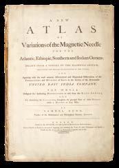
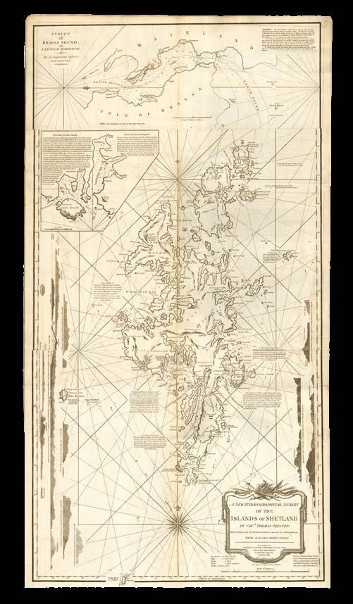
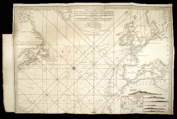
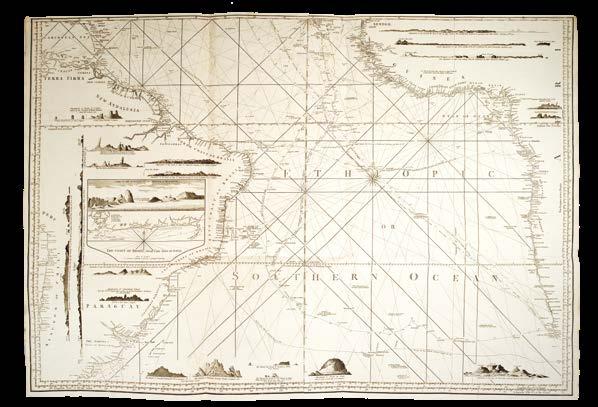
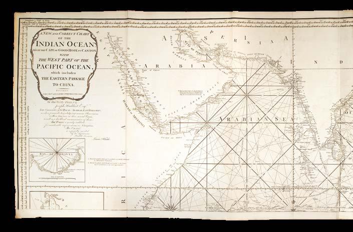
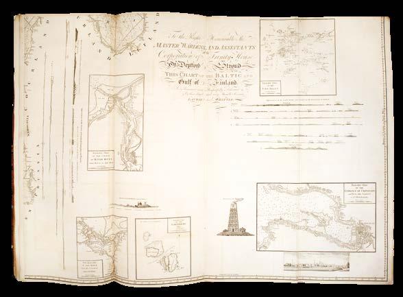
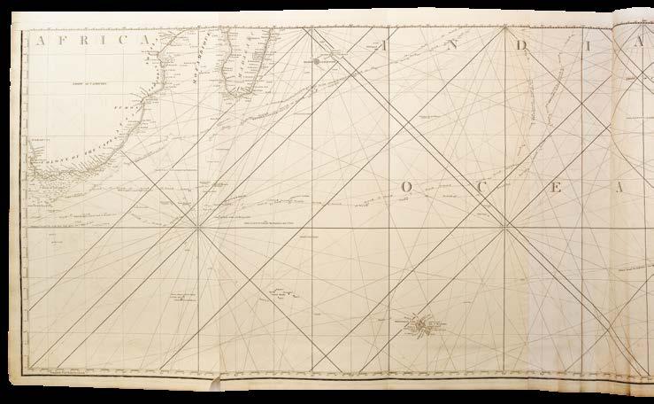
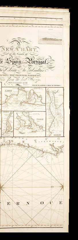
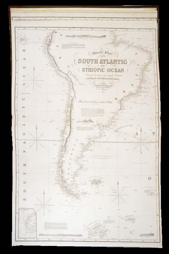
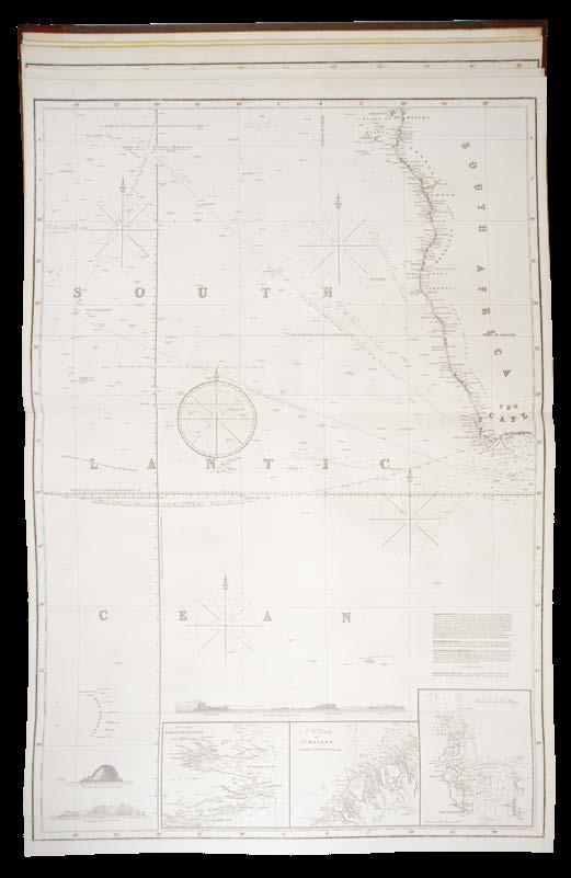
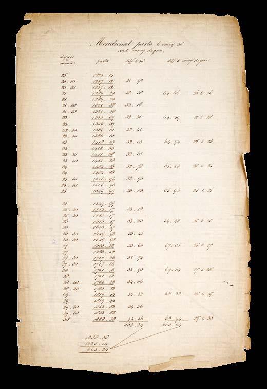
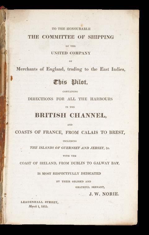
A new atlas of variations of the magnetic needle for the Atlantic, Ethiopic, Southern and Indian Oceans.
Publication
London, Printed for the author, and sold by him in Maiden-Lane, Covent Garden, 1776 [but 1788].
Description
Folio (543 by 365mm), 6 unsigned leaves of letterpress paginated xii, comprising title, dedication and introduction, 44 engraved charts, tables and diagrams on 28 sheets, of which 9 double-page mounted on stubs, first two double-page plates stained and spotted, occasional light soiling, spotting and staining to the remainder; contemporary half calf over marbled paper-covered boards.
A previously unrecorded enlarged edition on magnetic variation
Extremely rare publication of this significant contribution to the field of navigation and geomagnetism in the eighteenth century; we can only trace the London Library example in British libraries.
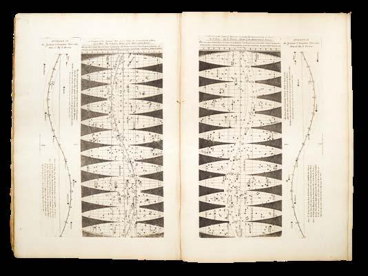
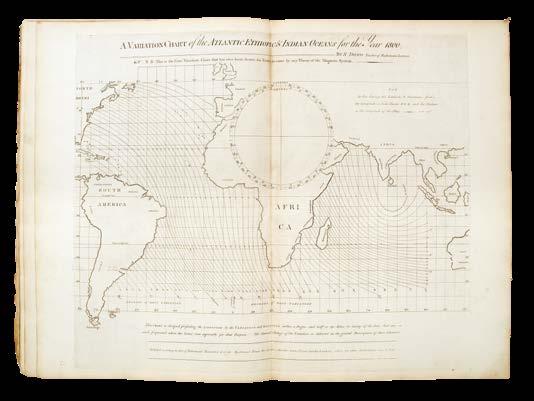
Dunn’s atlas provided sailors with crucial information about magnetic variations across vast ocean regions, which was essential for accurate navigation. This was particularly valuable at a time when determining longitude at sea was still a major challenge. The atlas was based on Dunn’s own theory of the magnetic system, demonstrating his attempt to understand and systematize the complex behaviour of the Earth’s magnetic field. Dunn endeavoured to bridge the gap between theoretical understanding and practical use, and to make his work directly relevant to mariners. The atlas itself has comprehensive geographical coverage of the [North] Atlantic, Ethiopic [i.e. South Atlantic], Southern, and Indian Oceans. In recognition for his work, Dunn was engaged by the East India Company as an examiner in mathematics for their cadets.
The present work is intriguing, as the double-page charts are mounted on stubs that are themselves made from old versions of Dunn’s charts. It is also extremely rare: no copies can be traced at auction (RBH); the only institutional copies that can be traced are those in the London Library, Danish Royal Library, and the Huntington Library. The London Library’s example is bound with the same author’s 24-pages, small quarto accompanying text, ‘The navigator’s guide to the Oriental or India seas, or, The description and use of a variation chart of the magnetic needle’, dated 1775.
The present example has the charts and diagrams uncoloured, while both the London Library and Huntington copies have the plates coloured in outline by a contemporary hand. Moreover, both these institutional copies have a plate not present here, namely ‘Variation Chart of the Atlantic Ethiopic & Indian Oceans for the year 1770... Published... November 6, 1776’.
However, the Huntington example lacks the first chart, ‘A Mercator’s or Wright’s Chart, shewing the course from one place to another … Published … November the 10th 1775’ which is present in both here and in the London Library example. The introductory text in the London Library only extends to p.vi, being dated October 28th 1776, whereas the present example paginates to xii with p.vii dated September 4th 1782. The latest date in the volume is plate 18 on sheet 9, ‘Longitude instructions’, with 29 August 1788. This suggests that the present example is a hitherto unrecorded later, and very much enlarged, edition.
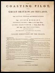
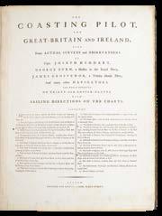
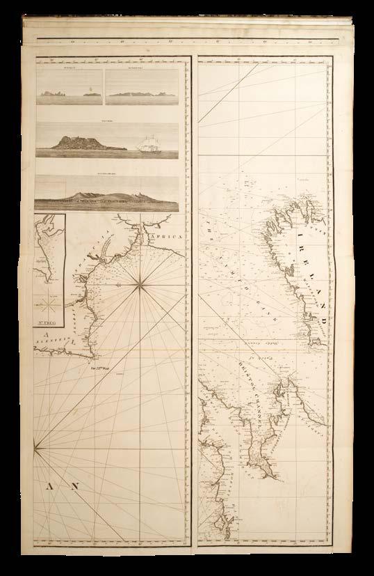
HUDDART,
Joseph; George BURN; and James GROSVENOR
The Coasting Pilot, for GreatBritain and Ireland.
Publication
London, Robert Sayer, [c.1788].
Description
Large folio (640 by 495mm). Eleven folding and eight double-page engraved charts, two with engraved lines indicating sailing channels highlighted by hand in red ink, without three charts and additional unnumbered chart of the British Isles (called for in contemporary ink manuscript) listed on title, chart 5 with very small loss along creasefold; chart 7 with long tear into sea area but without loss, chart 10 with light fraying and browning to western edge with tiny loss to border; contemporary half-calf over marbled paper-covered boards, red morocco gilt lettering piece to upper cover.
A rare pilot of home waters
Sayer’s publication of ‘The Coasting Pilot for Great-Britain and Ireland’ represents a pivotal advancement in eighteenth-century British hydrography, synthesizing cutting-edge surveying techniques, practical navigational expertise, and the geopolitical imperatives of an expanding maritime empire. Its charts provided sailors with unprecedented accuracy for navigating the complex coastlines of Britain and Ireland, reducing shipwrecks, enhancing trade efficiency, and bolstering naval dominance during a period of global conflict.
By the late seventeenth century, Britain’s reliance on maritime trade and naval power necessitated reliable coastal charts. The first systematic attempt to chart British waters was Captain Greenville Collins’s Great Britain’s Coasting Pilot (1693), and the demand for accurate charts intensified during the eighteenth century dictated by global geopolitics by way of the Seven Years’ War, American Revolution, and Napoleonic Wars.
Joseph Huddart FRS (1741–1816) was a British hydrographer, engineer, and inventor, who made a fortune from improving the design and manufacture of rope. He was commissioned by the publishers Sayer and Bennett to undertake a marine survey of the Irish Sea in 1777, which was then published in 1779. In 1778, Huddart sailed to Asia in the employ of the East India Company, and completed important surveys of the coast of India and Sumatra. These accomplishments made him well-known in cartographic circles, which is why, although Huddart had only ever undertaken the one survey in home waters, Sayer promoted his name on the title-page of the present work (Fisher p.58).
More prominent contributors to ‘The Coasting Pilot’ were George Burn, a master in the Royal Navy, and James Grosvenor, a Trinity House Pilot, whose hydrographic, naval, and pilotage expertise Sayer could use to produce charts that balanced scientific accuracy with real-world usability. Sayer’s practice of creating charts “done up in a portable manner” (quoted by Fisher p.57) but without text, led to him printing undated title-pages with a list of contents that could be made to serve for 20 or more years without change, although the charts within the atlases themselves would be the most recent versions at time of binding. This was an extremely flexible, and a profitable, way to publish, but did lead to charges that Sayer’s charts could be out of date and not reliable. For instance, in the present example, the dates on the charts range from 1781 through to 1788, so it could be argued that the earliest chart (‘A new hydrographical survey of the west coast of Ireland’) was seven years out of date at the time of publication. It also leads to difficulty dating the publication history of these atlases; we can only trace six institutional examples, all with later dates than the present work: British Library (example dated 1791-1803), Cambridge (two copies, one dated 1794, the other 1796 with two extra charts), RGS (dated 1797) National Library of Sweden (dated 1781-1797), and Harvard (dated 1787-1794).
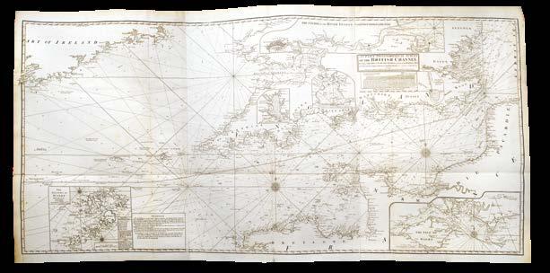
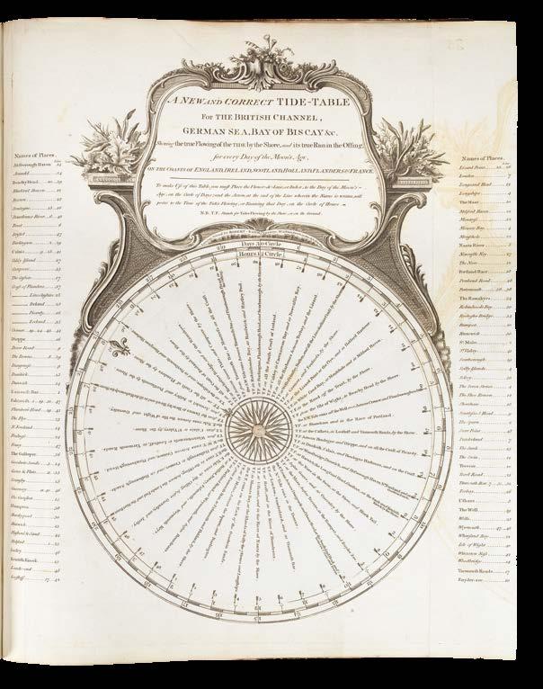
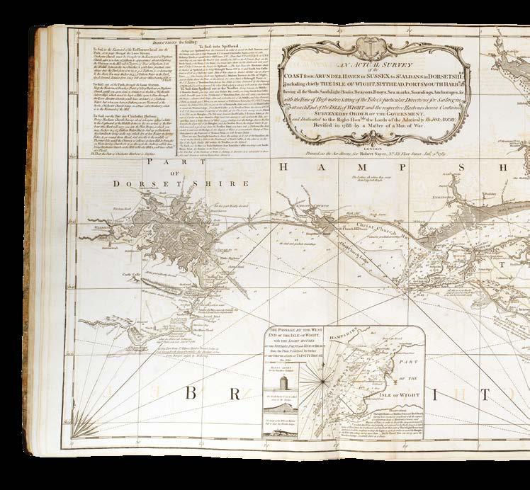
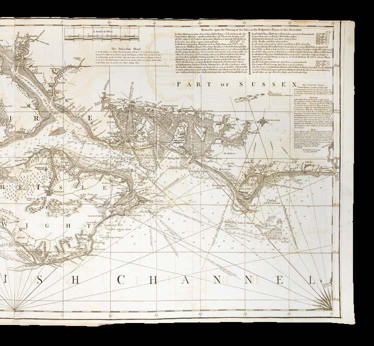
STEPHENSON, John; and George BURN
The Channel Pilot.
Publication
London, Printed for Robert Sayer, No. 53 Fleet-Street, [c.1789].
Description
Large folio (540 by 385mm). 24 engraved charts and one tide table, all numbered in ink stencil, four of which folding, 18 double-page, and two single-page, the final engraving being “A new and correct tidetable for the British Channel” printed on a single sheet with right-hand margin folded complete with one moving dial, some light offsetting throughout; contemporary half calf over marbled-paper covered boards, rebacked and recornered to style.
References cf. NMM III, 416.
In 1760, Robert Sayer moved to larger premises at 53 Fleet Street, which would be the firm’s home for the next 145 years. Sayer was very successful, and bolstered his business with canny acquisitions of stock and copperplates. In 1766, when his friend, the map publisher, Thomas Jefferys, was declared bankrupt, Sayer “was able to obtain control of ‘an important slice of Jefferys’s stock in trade – both manuscript drawings and notes and copper-plates” (Fisher, p.55). Soon after, Sayer took on John Bennett as a full partner, and this led to increased business. A series of American atlases were published reflecting the current geopolitics of the American Revolution, followed by the East India Pilot as demand for eastern trade routes increased.
Work then moved back to home waters, with the first Channel Pilot being published with 21 plates. “The first Channel Pilot included charts provided by Trinity House pilots such as Joseph Ross and James Grosvenor, and others, while for the enlarged version, with twenty-five charts [this example] … the principal contributors were two masters in the Royal Navy, George Burn and John Stephenson. Before the establishment of government charting in Britain it was quite acceptable for naval officers to produce charts while on official duties and sell them to commercial publishers” (Fisher, pp.55-6).
Although the title to the present work is undated – standard procedure for Sayer’s publishing practices – the latest date on the charts is 1789 (chart 9, “An actual survey of the coast from Arundel Haven in Sussex to St. Aldans in Dorsetshire”). It contains 24 charts, with an engraved tide table with moving volvelle bound at the end. The first chart is the 1786 variant of “A new chart of the British Channel” which is then later updated to 12 May 1800 and used in the Atlantic Pilot in this collection (see item 227).
The engraved trade of map and chart seller James Heskett on the front pastedown is interesting as it shows that Sayer was selling not only directly, but also through other dealers. Heskett of 13 Sweetings Alley, Royal Exchange, describes himself as: “Map, Print & Chart-Seller. Prints & Drawings neatly Framed & Glazed. Maps Beautifully Colourd [sic] and adapted for Librarys [sic] or Travelling. Globes & Mathematical Instruments, Books, Gunters-scales, Compasses, Pencils and India Ink. Charts properly fited [sic] up for Navigation. Drawing Books, & Reeve’s Superfine Colours. Atlases, East & West India Pilots.”
Provenance
Engraved bookseller’s label of the map and chart seller James Heskett on front pastedown.
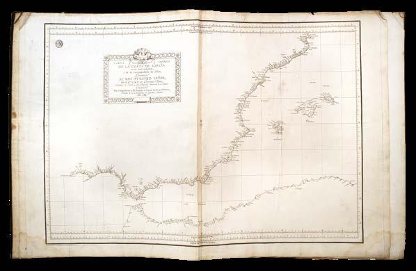
The first Spanish sea atlas, portraits hidden within
TOFIÑO DE SAN MIGUEL, Vicente
Atlas Maritimo de España.
Publication
Madrid, Vicente Tofiño De San Miguel, 1789.
Description
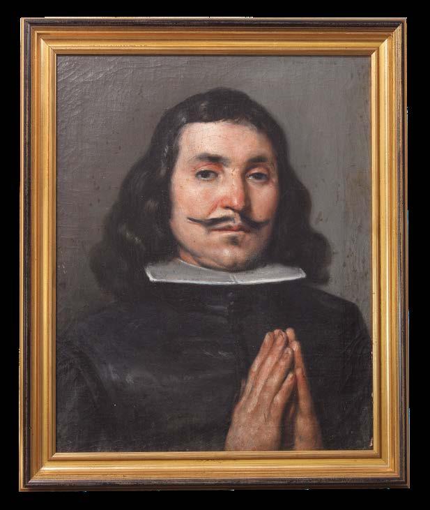
Two volumes. Large folio (625 by 485mm). Volume one: engraved title, 30 doublepage charts, plans, and coastal profiles, of which 22 are double-page, six charts with pencil grid annotations and ink marks, including two in English, chart five with tiny hole in a blank area; volume two: 11 charts and four coastal profiles, all double-page; some light creasing, staining, and soiling; contemporary Spanish sheep, not quite uniform, covers tooled with an identical border composed of a foliate scroll intertwined with a dotted roll, volume one bound in tree sheep with border enclosing single gilt fillet, volume two bound in mottled calf with the border enclosed by double-gilt fillet, accompanied by a pair of bust-length portraits (both 494 by 414mm), oil on canvas, on modern stretchers and framed to style, these originally hidden between the pastedowns and the boards.
References
Although no attribution can be confirmed, the loose brushwork is reminiscent of the hand of Juan de Pareja and Velázquez.
NMM III, 475; Phillips Atlases 9305 and 9306; Shirley British Library M.TOF1a; [Portraits] Gaceta de Madrid, 15th July 1873 (https://www.boe.es/gazeta/ dias/1873/07/15/pdfs/GMD-1873-196.pdf).
Spain’s first comprehensive hydrographic survey of its coastlines, ushering in a new era of scientific precision in nautical charting.
Commissioned by King Carlos III and executed under the leadership of Tofiño - a polymath naval officer, astronomer, and director of the Academy of Marine Guards in Cádiz - the atlas synthesized rigorous astronomical observations, advanced triangulation methods, and artistic craftsmanship to produce a work that redefined Spain’s maritime capabilities. Its creation marked a departure from Spain’s long-standing policy of cartographic secrecy, which had hindered the development of accurate navigational aids, leaving Spanish mariners reliant on outdated or imprecise charts. Carlos III, influenced by his reformist ministers such as Antonio Valdés y Bazán, recognized the strategic necessity of modernizing Spain’s naval infrastructure, and re-evaluated the necessity of cartographic secrecy in the light of Enlightenment ideals of scientific openness and technological progress.
Tofiño’s Expertise and Multidisciplinary Approach
Tofiño was entrusted with the monumental task of surveying Spain’s entire coastline over a period of five years (1783-1788), including its Atlantic and Mediterranean shores, the Balearic Islands, and territories in North Africa. Tofiño’s qualifications for this undertaking were unparalleled. A seasoned naval officer, he had participated in campaigns such as the 1775 invasion of Algiers and the 1782 siege of Gibraltar. His academic background in mathematics and astronomy, coupled with his directorship of the naval academies in Cádiz, Ferrol, and Cartagena, positioned him to integrate theoretical rigor with practical seamanship. His systematic survey combined celestial navigation, coastal triangulation, and bathymetric soundings.
Tofiño’s team established baselines along the shorelines, using theodolites to calculate angles between fixed points, thereby accurately triangulating the coastline. Astronomical observations, particularly longitudinal measurements based on the transit of Jupiter’s moons, further refined the charts’ positional accuracy, while prime meridians at Cádiz, Ferrol, and Paris were employed to align the atlas with international navigational practices.
Seabed Classification and Navigational Safety
One of Tofiño’s most innovative contributions was his system for categorizing seabed composition, denoted by letters such as P (piedra, or rock), L (lama, or mud), and A (arena, or sand). This notation provided mariners with critical information about anchorage suitability and potential hazardsa feature that enhanced navigational safety and operational efficiency.
Artistic Craftsmanship and Engraving Techniques
Rafael Mengs, Captain in the Royal Corps of Engineers, drew the plates, which were then engraved by Manuel Salvador Carmona, the renowned court engraver. The accurate charts are embellished by elaborate cartouches, allegorical motifs, and vignettes depicting naval instruments. The title page, for instance, incorporates astrological figures, the Spanish royal coat of arms, and scenes of maritime exploration, blending Baroque aesthetics with Enlightenment symbolism.
Atlas Composition
The first volume of the atlas focuses on Spain’s Atlantic littoral, extending from the northern ports of Santander and Bilbao to the southern reaches near Gibraltar. It includes detailed charts of the Canary Islands and the Azores, strategic waypoints for transatlantic voyages. Each chart provides not only coastal outlines but also hydrographic data such as tidal patterns, currents, and prevailing winds.
Volume two encompasses the Mediterranean coast from Gibraltar to Rosas, featuring intricate plans of ports such as Barcelona, Valencia, and Cartagena. The Balearic Islands of Majorca, Menorca, and Ibiza receive particular attention, with their harbours and anchorages meticulously documented.
Notably, the atlas extends to North African territories under Spanish influence, including Ceuta and Melilla, underscoring Spain’s geopolitical interests in the Mediterranean basin.
International Recognition and Influence
Tofiño’s atlas garnered acclaim beyond Spain’s borders. The French Academy of Sciences and the Royal Society in London lauded its scientific rigor, while navigators across Europe adopted its charts for Mediterranean and Atlantic voyages. The atlas’s dual emphasis on accuracy and aesthetics influenced subsequent nautical publications, including British Admiralty charts, which began integrating artistic elements alongside technical data. Therefore, in this context it is no surprise that this copy of Tofino’s atlas was the working copy used in the office of J. W. Norie, some thirty or forty years after publication. Six plates are annotated and marked with a grid in preparation for making copies: chart eight (Costas de Galicia y Portugal) has one ink mark and pencil grid annotations to five coastal profiles in English; chart 12 (Costa de Portugal) has three ink marks and pencil grid annotations to eight coastal profiles; chart 13 has two ink marks and pencil grid annotations to two coastal profiles; chart 14 has pencil grid annotations to five coastal profiles; chart 20 has pencil grid annotations to three coastal profiles; and the final plate (30) has two coastal profiles with small English pencil annotations (“to be reducedyou may square this of your area, do it lightly”).
Portraits
These nineteenth century users of the atlas seem to have been unaware of two seventeenth century Spanish portraits in oils which were found during cataloguing hidden between the pastedowns and the boards:
[SPANISH SCHOOL]
[Seventeenth century]
Oil on canvas, relined, minor old retouchings throughout Dimensions: each c490 by 413mm (framed 572 by 493mm)
The present portraits depict Don Pedro López de Sagade and his wife Doña Angela Fernandez de Arnesto, benefactors of one of the chapels of the Church of San Andres in Madrid. Although it is one of the oldest churches in the city, unfortunately the interior was completely destroyed during the Spanish Civil War.
The sitter’s identity is revealed through an inscription on the verso of each canvas. Their hands are clasped together, in prayer, following the typical austere compositions of seventeenth century Spanish painting; see for example the Portraits of a Gentleman and his Wife by Francisco Pacheco in the Museo de Bellas Artes in Seville.
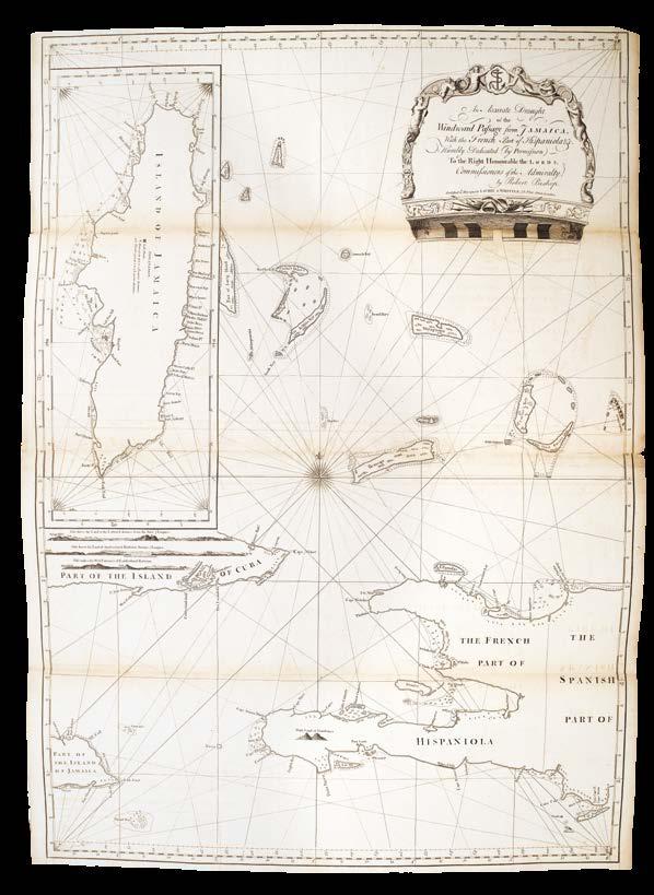
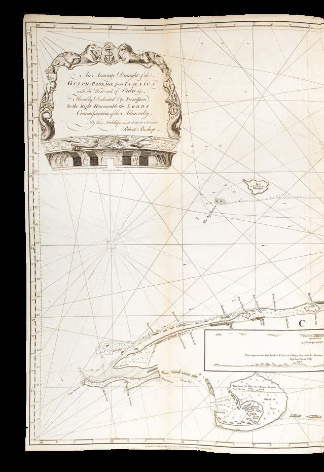
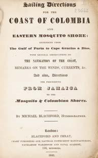
BISHOP, Robert
Captain Bishop’s Original Charts of the Gulf & Windward Passages, Old Straits of Bahama, &c.
Publication
London, Robert Laurie and James Whittle, 1796.
Description
Tall folio (730 by 265mm). Three folding engraved charts, mounted dos-a-dos and with blue paper backing to inner folds; original publisher’s paper-backed blue wrappers, large letterpress paper label on upper cover.
The Windward Passage was a maritime corridor between Cuba and Hispaniola, and the Old Straits of Bahama, threading through the Bahama Banks, as a vital artery for European colonial powers, facilitating trade, military deployments, and communication between the Atlantic and the Caribbean. However, the narrow channels, shifting sandbars, and unpredictable currents posed significant risks; accurate charts were essential to avoid shipwrecks.
These three charts contain the earliest imprint of Laurie and Whittle, 12 May 1794, probably the day they became the new proprietors of Robert Sayer’s business (see Fisher, p.61). All three were published earlier as part of Thomas Jeffreys’ The Atlantic Pilot by Laurie and Whittle in 1794 (see Christie’s New York, sale 8536, 8 November 1996, lot 81), but they are in fact much older in origin. The first chart, “An Accurate Draught of the Gulph-Passage from Jamaica with the West end of Cuba, & c.” has a note on the Florida peninsula that reads “Published by the Author May 20 1761”. Sayer’s practice of creating charts “done up in a portable manner” (quoted by Fisher, p.57) but without text, was therefore adopted by his successors, ostensibly offering a different, more specialized product. While extremely flexible, and a profitable way to publish, it did lead to charges that these charts were out of date and unreliable in area where accuracy was of prime importance. In fact, these charts were already obsolete by the time of publication, as newer hydrographic data emerged from the Napoleonic Wars.
DISTON, John
Diston’s Collection of Charts, from London to the Humber.
Publication
London, Robert Sayer [but Robert Laurie and James Whittle], [c.1797].
Description
Folio (535 by 375mm). Six double-page engraved charts, pasted dos-a-dos, charts offset, fourth chart trimmed close to border at southern edge; original publishers paperbacked blue wrappers, large letterpress paper label on upper cover.
Sayer’s
Fascinating update of Robert Sayer’s atlas of John Diston’s charts. Originally published in the 1760s, this atlas retains Robert Sayer’s imprint on the label on the front cover. However, Laurie and Whittle’s imprint appears on two of the charts, the third chart also bearing the date of 12 May 1797. It’s also probable that the final chart was published c.1786. With control of the cartographic publishing activities passing to Laurie and Whittle in 1794 after the death of Robert Sayer, this atlas indicates that they continued Sayer’s practice of issuing undated titles with new charts matching an existing list of contents. In this instance, they have actually reused a label printed for Robert Sayer, making no attempt to update the imprint, even though some of the charts are up-to-date with Laurie and Whittle imprints. This was an extremely flexible and profitable way to publish - and is an indicator of their good commercial instinct.
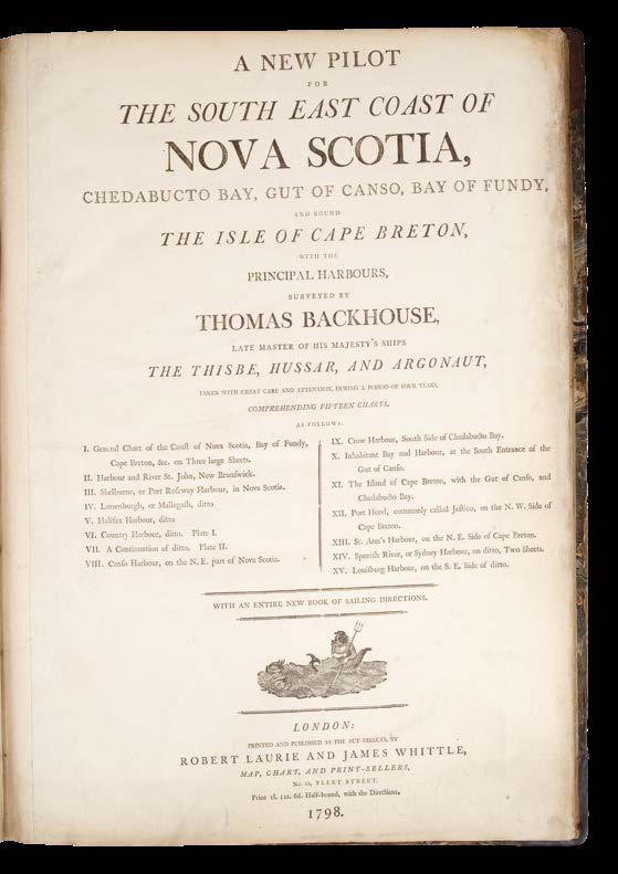
BACKHOUSE, Thomas
A New Pilot for the South East Coast of Nova Scotia.
Publication
London, Printed and Published … by Robert Laurie and James Whittle … No. 53, Fleet Street, 1798.
Description
Folio (525 by 380mm). Two unsigned letterpress leaves comprising title and dedication leaf to Earl Spencer, 15 engraved charts, two of which folding and the remainder double-paged, first chart with large repaired tears without loss but with some staining including ink stains and some pencil annotation to verso, chart two with a few minor marginal tears, nicks and dustsoiling, a few other very minor marginal repaired tears, a couple of minor nicks and some occasional faint offsetting, browning and soiling; publisher’s half calf over marbled paper-covered boards, rebacked and recornered.
The copy of the Surveyor-General of Cape Breton
Extremely rare and important maritime atlas with an exceptional association. Laurie and Whittle’s 1798 publication of this atlas of the eastern coast of Nova Scotia is extremely significant. With the loss of the American colonies in the Revolutionary War, Britain required accurate hydrography for safe passage to support the loyalist communities that remained in what is now modern-day Canada.
Moreover, the strategic and commercial importance of these waters to the British during the Napoleonic Wars cannot be understated. The southeastern coastline of Nova Scotia, particularly Chedabucto Bay and the Gut of Canso (now called the Strait of Canso), constituted a critical maritime corridor connecting the Atlantic Ocean to the Gulf of St. Lawrence; and to maintain their maritime hegemony, the Royal Navy required timber for shipbuilding, which the Canadian forests provided in abundance.
This atlas is one of the few Laurie and Whittle productions that did not reuse or update existing charts. Instead, this was a completely new publication, with all 15 charts engraved from surveys by Thomas Backhouse, supplied by him directly to Laurie and Whittle for their exclusive use (Fisher, p.61).
The ink ownership inscription on the dedication leaf hints at an extremely important association, since “T. Crawley” is most likely to be Thomas Crawley (1757-1851). Thomas Crawley was born in Ipswich, serving in the Royal Navy and retiring as a captain in the 1780s. After his retirement, he held a number of positions in the colonial government of Cape Breton, with his name appearing on the list of members of the Executive Council in 1788, 1794, 1806, 1807, 1812, and 1820. In 1803, Crawley was appointed to the post of Surveyor-General of Cape Breton, in which capacity such an atlas would have been extremely useful. Although the Surveyor’s responsibilities were mainly terrestrial rather than maritime, dividing lots of land for settlers and completing the grants for purchased lands, presumably a sure cartographic knowledge of the coastline would have been imperative.
Thomas Crawley retired as a surveyor in about 1834, choosing to make his home in Westmount, opposite the town of Sydney in north-east Cape Breton. Today, Crawley’s Creek, a small inlet at the northern end of Westmount, is named for him; this yet unnamed feature is shown on the penultimate chart in the present work “A survey of Spanish River or Sydney Harbour”. Extremely rare: we have been only able to trace three institutional examples: Houghton Library, Harvard; Roger S. Baskes Collection at the Newberry Library; and Library and Archives Canada, Ottawa, this apparently hand-coloured, but seemingly lacking the first two charts. No example can be traced in the British Isles.
Provenance
Contemporary ink inscription of T. Crawley on dedication leaf.
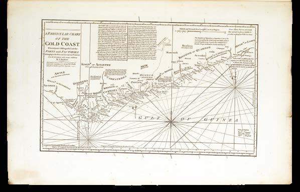
LAURIE, Robert; and James WHITTLE
The Guinea Coast Pilot.
Publication London, Robert Laurie and James Whittle, [c.1800].
Description
Folio (540 by 360mm). Six engraved charts, all but one double-page, second chart trimmed close with some loss to border and numerals at head, final two charts with occasional nicks and light soiling at head, charts with some light offsetting; original publisher’s paper-backed blue wrappers, large letterpress printed paper label on upper cover, lower cover stained, upper cover faintly soiled.
The Gold Coast of Africa
An extremely rare pilot, which extends from the English Channel to the Gold Coast of Africa. The maps themselves are based on earlier cartography: for example, the first chart of the English Channel, while the imprint is dated to 12 May 1800, names Thomas Jefferys (d1771) as the cartographer; and the second through to the fifth charts, while all dated 12 May 1794, name various cartographers, including Bellin, D’Apres de Mannevillette, and D’Anville, all of whom were already deceased.
It is worth noting that the first three charts all appear in the ‘Neptune Occidental’ (1803) (see item 222), and ‘A Small West India Pilot’ (1801) (see item 217), with the second and third charts also appearing in ‘The Atlantic Pilot’ (1811) (see item 227). Robert Sayer’s catalogue of 1787 (see item 250) lists the ‘Guinea Coast Pilot’, and this reissuing and updating some 13 years later by Sayer’s successors shows that not only was there still a market for Africa hydrographic charts, but also that money could be saved by reusing charts in different atlases purporting to cover different geographies.
We have been unable to trace a single example at auction, and only one institutional example, held by the Royal Geographical Society.
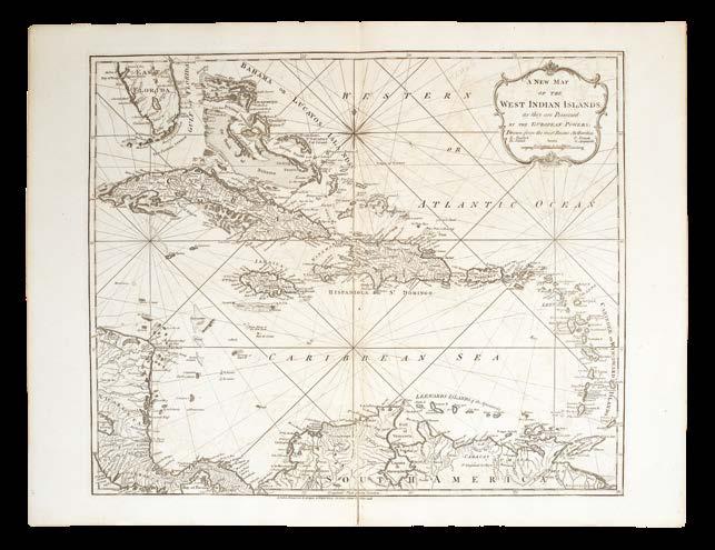
LAURIE, Robert; and James WHITTLE
A Small West India Pilot.
Publication
London, Printed and published by Laurie and Whittle, No. 53, Fleet Street, 1801.
Description
Tall folio (545 by 360mm). Eight doublepage engraved charts, mounted dos-a-dos, some light offsetting and soiling; original publisher’s paper-backed blue wrappers, large letterpress paper label to upper cover, rebacked.
A pilot of the Caribbean
An extremely rare pilot containing eight engraved charts designed for those wishing to sail from England to the Caribbean. The maps themselves are based on earlier cartography: the first chart of the English Channel gives Thomas Jefferys (d1771) as the cartographer, but the imprint date is 12 May 1800; the remaining charts are all dated 12 May 1794, with various cartographers including Bellin, Pownall, D’Apres de Mannevillette, Fleurieu, and D’Anville, bar chart five ‘A new map of the West Indian Islands’ which is dated 12 May 1795, and the penultimate chart, ‘The Bay of Honduras … Corrected and Improved in 1800’.
As can be seen from other atlases in this collection, charts were reused to reduce costs, and the present work shares its first three charts with the ‘Guinea Coast Pilot’ (1800) (see item 216) and the ‘Neptune Occidental’ (1803) (see item 222); the second and third charts are also found in ‘The Atlantic Pilot’ (see item 227), published in 1811.
We have only been able to trace one institutional example, held by the British Library.
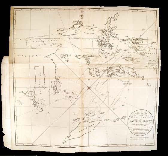
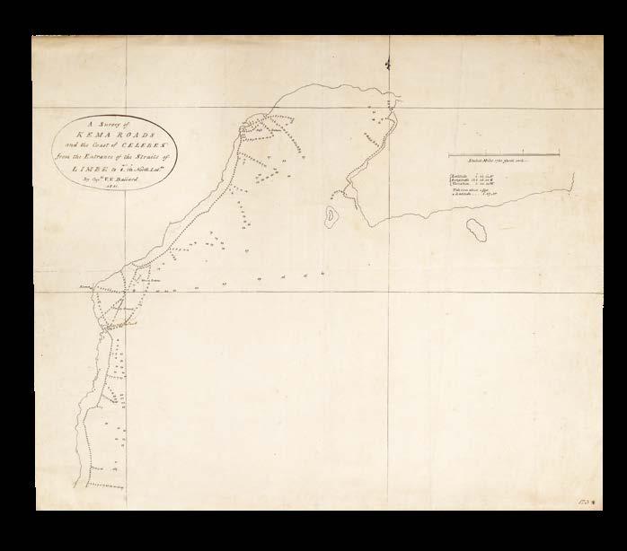
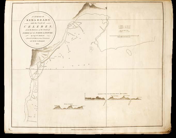
MOOR, Henry
A New General Chart of the Molluccas and Eastern Islands.
Publication
London, Robert Laurie and James Whittle, 1801.
Description
Folio (575 by 455mm). Five engraved charts, including one folding, three manuscript charts loosely inserted; original publisher’s paper-backed blue wrappers, large letterpress paper label to upper cover, label with either price or date erased, small chip to fore-edge of upper cover, corners slightly dog-eared.
When Robert Sayer died on 29 January 1794, he left his fortune and his business to his son, James Sayer. However, James does not seem to have played any part in the business, and instead it continued to be run by Robert’s assistants, Robert Laurie and James Whittle. They started using the Laurie and Whittle imprint from 12 May 1794, reissuing a large number of Sayer’s plates under their joint names. They continued Sayer’s practice of re-issuing pilots with updated charts as and when required, but occasionally they invested in completely new charts that were exclusive to the firm and were issued under completely new titles.
The present work is one of those publications. Laurie and Whittle engaged Lieutenant Henry Moor (c.1780-1810; sometimes spelled “Moore”) of H.M. Sloop ‘Hobart’ to produce these five charts of the East Indies, and supply them directly to the publishers (see Fisher, p.61).
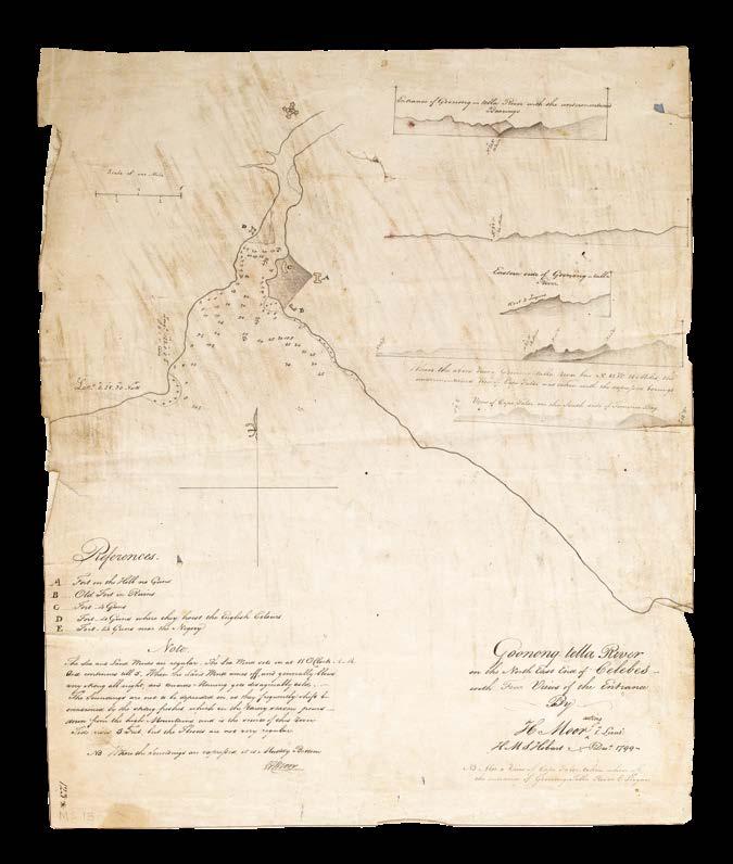
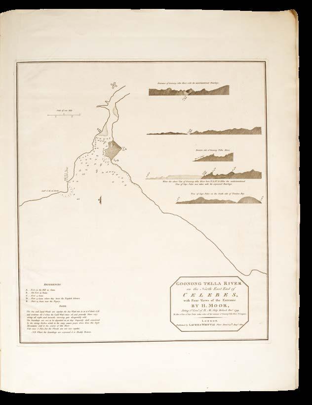
This example is accompanied by three associated manuscript charts, which are loosely inserted: an ink manuscript chart of the southern portion of the first chart, ‘A new chart of the Molluccas and eastern islands’, with title cartouche pencilled in outline, a few soundings and one toponym in red ink, folded twice, with ink manuscript inscription on verso “Original drawings of the Molucca Islands by Lieut. Moore. Reduced by Mr Snowy, 1801” (lightly soiled, with very small closed tear in blank area); an ink manuscript chart by Captain V.V. Ballard, accompanying the chart ‘A Survey of Kema Roads’; and an original ink and pencil manuscript chart, signed by H. Moor, accompanying the ‘Chart of the Goonong Tella River (also see item 208 for another Moor manuscript).
Very rare: we have been unable to trace a single example at auction (RBH); it is possible that the Royal Geographical Society has an example of this atlas, but this has not been verified.
LAURIE, Robert; and James WHITTLE
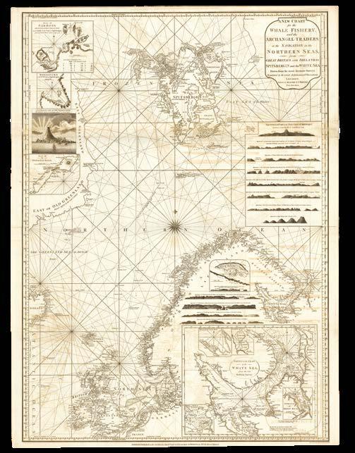
A Pilot for the Greenland Whale Fishery.
Publication
London, Published by Robert Laurie and James Whittle, map, chart, and printsellers, No. 53 Fleet Street, 1802.
Description
Tall narrow folio (740 by 275mm). Seven engraved charts, of which three folding, mounted dos-a-dos, browned and offset throughout; original publisher’s paperbacked blue wrappers, large letterpress paper label on upper cover, prices altered in ink manuscript from “fifteen” to “16” shillings, small repaired area to lower cover, just affecting border of final map.
“I love to sail forbidden seas, and land on barbarous coasts.” (Melville)
A cynic might argue that this atlas represents everything that was wrong with private chart publication at the end of the eighteenth and beginning of the nineteenth centuries. It was undoubtedly published by Laurie and Whittle to take full commercial advantage of the Scottish whaling industry’s strategic shift to the waters of the Davis Strait separating the western coast of Greenland and Baffin Island.
By the late eighteenth century, Scottish whalers dominated the pursuit of bowhead whales (Balaena mysticetus) in the Greenland Sea, driven by demand for whale oil and baleen. However, declining catches in traditional grounds prompted a westward shift to the Davis Strait and Baffin Bay after 1800. This transition required navigating uncharted or poorly mapped regions fraught with sea ice, icebergs, and unpredictable weather. The hazards were stark: over 50% of Scottish whaling vessels venturing to the Arctic seas between 1750 and World War I were lost, claiming hundreds of lives. In this context, accurate nautical charts became indispensable for minimizing risks and maximizing returns.
Laurie and Whittle were well-positioned to meet this demand. Their firm had already established credibility through works like the East-India Pilot, and thus the 1802 Pilot for the Greenland Whale Fishery represented an extension of their expertise into the Arctic.
Moreover, the Peace of Amiens in 1802 had the effect of expanding Arctic whaling operations. This temporary cessation of hostilities between Britain and France reveals a critical nexus between geopolitical stability and maritime resource exploitation. During the War of the Second Coalition (1798-1802), French privateers had targeted British merchant vessels, including whalers, disrupting voyages and inflating insurance costs. The treaty’s 14-month truce (March 1802-May 1803) provided a window of relative safety, allowing whalers to venture into distant Arctic grounds.
With this atlas, Laurie and Whittle were trying to supply an increased demand for charts for the northern seas, but for those captains of the whalers expecting to see the latest cartographic information, they were to be sorely disappointed. As Fisher describes, “apparently new titles, such as A Pilot for the Greenland Whale Fishery (1802), included one or two new charts but were otherwise simply new groupings of existing charts” (p.61).
The latest chart in the atlas is dated 1799, already three years old by the time this atlas was published, while the remaining charts are dated between 1794-1797. For Davis Strait expeditions, which required vessels to traverse the Labrador Current – a region notorious for ice hazards and already fraught with operational risks – this atlas was already out of date and unreliable. Truly reliable surveys producing new charts of the relevant areas would not come until a lot later with Laurie and Whittle’s employment of John Purdy, who produced a large detailed chart of the North Sea in 1806, and one of the Atlantic Ocean in 1812.
Effectively this atlas was a cynical exercise in opportunistic publishing to meet quickly the demand created by a sudden change in geopolitics. Extremely rare: we have been unable to trace a single example to have appeared at auction, and only one institutional example, held by the British Library.
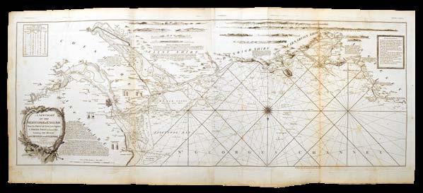
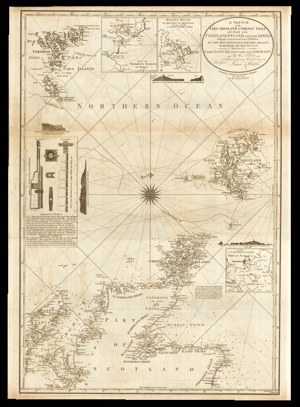
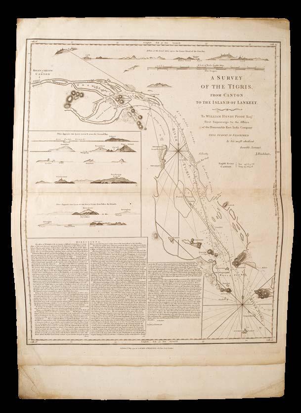
HUDDART, Joseph
A Coasting Pilot for the western seas of Great Britain.
Publication
London, Robert Laurie and James Whittle, 1802 [but 1810].
Description
Tall narrow folio (820 by 305mm). Five engraved folding charts on six sheets, sheets one and two with extension flaps, a few minor old repairs, mainly to creasefolds; original publisher’s paperbacked blue wrappers, large letterpress paper label on upper cover, extremities lightly rubbed and soiled.
The western navigation
A comparison between this atlas and the “New and Improved Edition”, under the same title, dated 1811 (see item 229), reveals that this work, despite bearing the date 1802, is actually closer in age to the 1811 edition, and can, in fact, be dated to 1810. One major difference is that this work contains a fifth chart, “A sketch of the Faro, Shetland & Orkney Islands,” dated 1797, which does not appear in the 1811 edition.
When Laurie and Whittle took over Robert Sayer’s business in 1794, they adopted Sayer’s practice of creating charts “done up in a portable manner” (quoted by Fisher, p.57) but without text. This offered an extremely flexible, and a profitable way to publish, although it did lead to charges that these charts were out of date and unreliable in areas where accuracy was of prime importance. In this instance, the first chart is dated 1809, while the fifth, that of Shetland, is dated 1810. Presumably it made economic sense to use up old printed labels retaining an old date, while making sure the contents were as up-to-date as possible.
Joseph Huddart’s name appears frequently on the publications of Robert Sayer, and later on those of Laurie and Whittle. The publishers Sayer and Bennett first commissioned Huddart to undertake a marine survey of the Irish Sea in 1777, but then Huddart spent the following decade in the employ of the East India Company in Asia. There, he completed important surveys of the coast of India and Sumatra, making him well-known in cartographic circles, which is why Sayer continued to promote his name on the title-page of British pilots. However, in 1788 Huddart returned to the British Isles and completed surveys of the Hebrides which formed the basis for this atlas. Although the present work is a late edition of 1810, Huddart’s name, as influential as ever, still appears on the title, even though he would have been 69 years old at the time of publication.
HUDDART, Joseph; George BURN; and James GROVESNOR
The Coasting Pilot, for GreatBritain and Ireland.
Publication [London], Printed for Robert Sayer [i.e. Laurie and Whittle], Fleet-Street, [c.1803].
Description
Large folio (635 by 480mm). 26 engraved charts comprising 13 folding and 13 double-page, one with engraved lines indicating sailing channels highlighted by hand in red ink, complete with additional unnumbered chart of the British Isles bound in at beginning as the first chart, and three charts of ‘Quiberon Bay’, ‘A sketch of the Faro, Shetland & Orkney Isles’, and ‘Coast of Yorkshire’ called for in contemporary ink manuscript on title, chart 4 with very short neatly repaired marginal tear, final chart with faint ink stain in margin, some variable offsetting and browning throughout; slightly later flexible paper-covered boards, rebacked with calf spine to style.
“done up in a portable manner”
Sayer’s ‘The Coasting Pilot for Great-Britain and Ireland’ was in constant demand as its charts provided sailors with unprecedented accuracy for navigating the complex coastlines of Britain and Ireland. However, Sayer’s practice of creating charts “done up in a portable manner” (quoted by Fisher, p.57) but without text, led to him printing undated title-pages with a list of contents that could be made to serve for 20 or more years without change, although the charts within the atlases themselves would be the most recent versions at time of binding. In the present example, the first folding chart ‘A new and accurate chart of the mouth of the Thames’ is dated 1803, with the following chart dated 1800. However, the rest of the charts are dated between 1794-1798, which means many of the charts were almost a decade old at the time of publication. It also leads to difficulty dating the publication history of these atlases; the only institutional holding that we can trace with a similar date to the present work is that in the British Library (example dated 1791-1803).
The
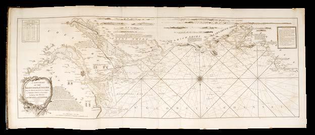
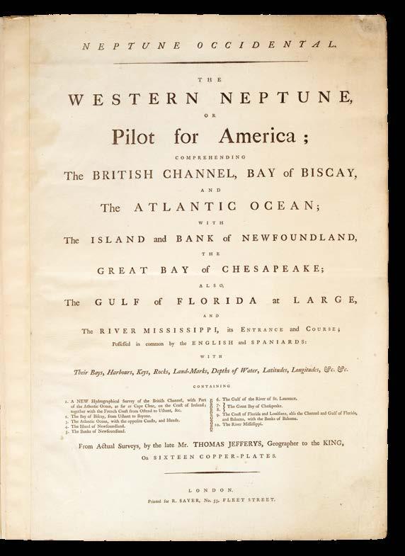
JEFFERYS, Thomas
Neptune Occidental. The Western Neptune, or pilot for America.
Publication London, Printed For R. Sayer, No. 53, Fleet Street, [c.1803].
Description
Folio (545 by 400mm). Letterpress titlepage, nine charts on ten sheets mounted on stubs, of which five folding, a few charts trimmed close to borders, very faint soiling and offsetting; original publisher’s paperbacked blue wrappers, rebacked, printed paper spine label “Western Neptune”.
In 1760, Robert Sayer moved to larger premises at 53 Fleet Street, which would be the firm’s home for the next 145 years. Sayer was very successful, and bolstered his business with canny acquisitions of stock and copper plates. In 1766, when his friend, the map publisher, Thomas Jefferys, was declared bankrupt, Sayer “was able to obtain control of ‘an important slice of Jefferys’s stock in trade – both manuscript drawings and notes and copper-plates” (Fisher p.55). Jefferys had been collecting the best maps and charts of North America, but overreached himself leading to financial disaster. Sayer took full advantage of the situation, becoming the controlling partner in Jefferys’s publications. These included the important ‘A General Topography of North America and the West Indies’ (1768).
Sayer took on John Bennett as a full partner in the 1770s, and this led to a reinvigoration of the business. Due to the American Revolution, there was interest in, and demand for, this geography, and Sayer and Bennett issued an important series of atlases based on Jefferys’s stock: ‘The West India Atlas’ (1775), ‘The American Atlas’ (1775), ‘The North American Pilot’ (1775), and ‘The Neptune Occidental’ (1778).
This latter was republished several times, with some changes to the title. The present work is a Laurie and Whittle nineteenth-century publication that seems to elide the titles of ‘The North American Pilot’ and ‘The Neptune Occidental’ (1778) into one, albeit with this title undated and with a Sayer imprint.
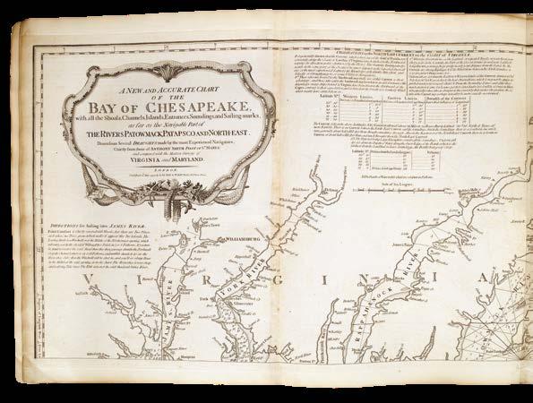
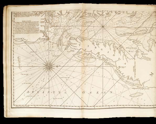
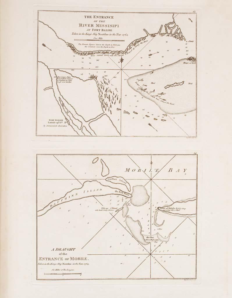
The present work contains nine engraved charts designed for those wishing to sail from England to the eastern seaboard of North America. The first chart shows the English Channel (‘The British Channel’, 1800), with those of the Bay of Biscay and the Atlantic (both dated 1794) following. As one might expect, the publishing practices of the day dictated that charts be reused to keep costs down, and these three charts are also included in the ‘Guinea Coast Pilot’ (1800) (item 8) and ‘The Small West India Pilot’ (1801) (item 9); the second and third charts are also found in ‘The Atlantic Pilot’, published in 1811 (item 19).
The present atlas then has charts that go north to Newfoundland (two charts, one dated 1794, the other 1803) and the mouth of the St Lawrence River (1794). Heading south, there is a two-sheet chart of the Chesapeake Bay (1794), followed by one of Florida and Louisiana (1794), with the final chart being of the Mississippi River (1800).
Records of this exact title can be traced to the following editions: 1789 (British Library), c.1794 (two pre-War American auction catalogue entries), c.1800 (British Library), and c.1803 (Huntington Library). This latter matches the composition of the present work, but is imperfect, lacking the first chart.
Sabin 35956 only cites editions printed in 1788 or later; all editions are very rare, with only two copies of the 1778 edition appearing at auction in the last 50 years.
LAURIE, Robert; and James WHITTLE
The Small East India Pilot.
Publication
London, Published by Laurie and Whittle, No. 53, Fleet Street, 1797 [but c.1807].
Description
Tall folio (535 by 385mm). Five engraved charts on seven sheets mounted on stubs, of which five folding and one double-page, light offsetting and soiling; original marbled paper wrappers, large letterpress paper label to upper cover, another large letter press label affixed to verso of front wrapper, small nick to spine, rebacked reusing original drab paper backstrip, corners repaired.
Extremely rare pilot with two titles, demonstrating cartographic publishing practices of the late eighteenth and early nineteenth centuries. Robert Sayer, and later, also, his business partner, John Bennett, had continued success publishing a large output of atlases with hydrographic charts covering varied geographies. By 1776, Sayer had completed 31 charts of eastern seas that were to be the basis for the ‘East India Pilot’.
Eventually, this would grow into a much larger two-volume work with 108 charts, covering the whole route from the Thames to China. The majority of these charts were dated 1778, although some were not published until 1781, but Sayer was expedient in printing a title-page without date, so this could be reused for further iterations of the atlas.
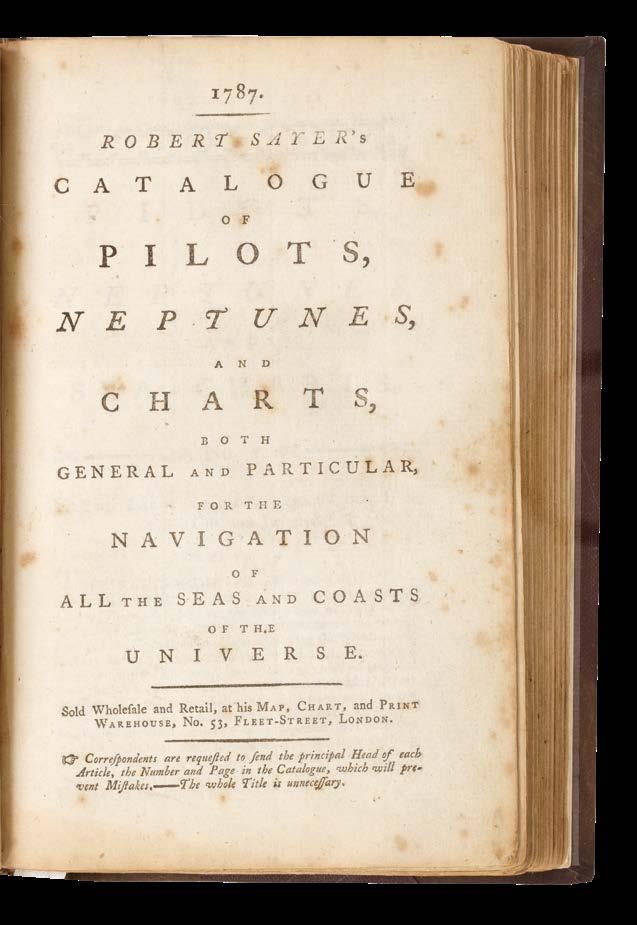
By 1787, Sayer’s catalogue – listing some 25 pilots – shows that as well as offering the large ‘East India Pilot’, small selections of about half-adozen charts could also be purchased. This canny commercial opportunism and flexibility was adopted by Sayer and Bennett’s successors, Laurie and Whittle, who continued offering charts “done up in a portable manner” (quoted by Fisher p.57) but without text.
The present work is one of these small selections of charts, offering five charts on seven sheets, and has two title-pages, one titled ‘The Small East India Pilot’ on the front wrapper with the imprint of Laurie and Whittle and dated 1797, the other pasted onto the verso of the front wrapper with the title ‘The New East India Pilot’ with the imprint of Robert Sayer and undated. The charts themselves cover the English Channel, North Atlantic, Rio Janeiro, Indian Ocean, and Canton; the Atlantic chart bears the latest date of 1807, while the final chart is based on a Joseph Huddart survey of the 1770s, and is dated 1794, perhaps only some 30 years out of date!
Extremely rare under either title: the only institutional example that seems to conform to the present atlas is the that held by the British Library, under ‘The New East India Pilot’, with ‘The Small East India Pilot’ given as a subsidiary title. The BL example is dated 1797-1807, and is catalogued as having seven charts. The only other example that we can trace which almost matches the present pilot is that in Dartmouth Library, NH, USA, which is catalogued under the title of ‘The Small East India Pilot’, dated 1796, and contains three folded maps on three sheets only.
LAURIE, Robert; and James WHITTLE
Laurie and Whittle’s Improved Coasting Pilot.
Publication
London, Printed and published by Robert Laurie and James Whittle … No. 53, Fleet Street, 1809 [but c.1813].
Description
Folio (540 by 390mm). Eleven engraved charts on 13 sheets all numbered by ink stencil, of which ten folding and three double-paged, the charts of British waters with the lighthouses picked out in yellow original hand-colouring, a fine clean copy with only chart two just trimmed into top outer border, charts three, four, and five with very small repairs to creasefolds, this just obscuring some engraved areas on charts four and five, occasional faint offsetting and browning, chart nine fractionally more affected; contemporary half calf over marbled-paper covered boards, expertly rebacked and recornered to style, extremities faintly rubbed.
The second known example
The publication of ‘Laurie and Whittle’s Improved Coasting Pilot’ represents a significant milestone in British maritime cartography, coinciding with a transformative period in the regulation of coastal navigation. Prior to 1809, the practice of pilotage remained largely unregulated. Any seafarer could offer pilotage services to approaching vessels, regardless of their qualifications or knowledge of local waters. This system relied predominantly on reputation rather than verified competence, creating considerable risk for maritime commerce.
The hazards of this arrangement became increasingly apparent as maritime trade expanded. George Rose, Vice-President of the Board of Trade, stated in February 1808 that, “Not less than five East Indiamen had been lost within these few years... owing entirely to the negligence of Pilots” (reported by the ‘Kentish Weekly Post or Canterbury Journal’, 1 March 1808). The economic and human costs of these disasters prompted growing concern, and after several failed legislative attempts, Parliament finally enacted new regulations in 1809 that established a formal licensing system for pilots.
This stimulated a growing demand for detailed navigational charts for coastal waters, and despite the present work giving the date of 1809 on the title-page, the first three charts, covering British waters and the North Sea, are later, more up-to-date editions of 1812-1813.
This particular atlas would have also been in demand for British naval activities, since the period of 1809-1813 saw the Royal Navy sustain their presence in the Baltic Sea maintaining vital supply lines, supporting allied nations against Napoleonic influence, and countering the effects of the Continental System. The Baltic Fleet, also known as the Baltic Squadron, represented one of the Royal Navy’s key operational formations during the Napoleonic era. Napoleon’s Continental System, established following the Treaty of Tilsit between Napoleon and Tsar Alexander in 1807, specifically aimed to exclude all British merchantmen and warships from European ports, with Russia taking responsibility for enforcing Britain’s exclusion from the Baltic.
However, the Baltic held tremendous importance for Britain’s naval and economic interests. It served as Britain’s primary source of essential naval stores, including hemp, flax, and timber – materials absolutely crucial for maintaining the Royal Navy’s numerical and qualitative advantages over its rivals. Since Britain’s naval dominance was its main bulwark against Napoleonic France, it was strategically imperative for the Royal Navy to maintain open sea lanes to the Baltic. Although the Admiralty produced their own charts, it seems likely that this atlas would have been of naval use too.
Extremely rare: we have only been able to trace one institutional example, held by the British Library.
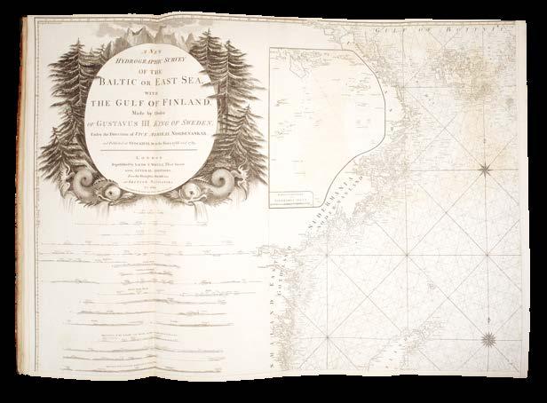
LAURIE, Robert; and James WHITTLE
A New and Enlarged Baltic Pilot.
Publication
London, Published by Robert Laurie and James Whittle … No. 53, Fleet Street, 1809 [but c.1819].
Description
Tall, narrow folio (740 by 305mm). 8 engraved charts on 11 sheets, 9 folding and 2 double-paged, some faint browning and offsetting; contemporary half calf over original marbled-paper covered boards, rebacked and recornered to style, extremities fractionally rubbed.
A rare Baltic pilot
‘The Baltic Pilot’ was first published by Robert Sayer in about 1790, and then republished in 1802 by his successors Robert Laurie and James Whittle with the contents entirely revised or re-engraved. This went through further iterations, including Laurie and Whittle’s ‘Improved Coasting Pilot’ (1809-1813) (see items 224), with this final third edition appearing in 1809. However, like so many other Laurie and Whittle publications, although the present atlas shares six charts with the ‘Improved Coasting Pilot’, the third chart of the North Sea – one of John Purdy’s first publications for Laurie and Whittle – is thoroughly revised with the imprint, “Published Augt. 2nd 1819, by Richard Holmes Laurie”.
Richard Laurie had taken over the running of the firm upon James Whittle’s death in December 1818, so this indicates that this atlas was one of Richard Laurie’s first publications and that he intended to continue the tradition of nautical publishing – a decision that Fisher suggests was heavily influenced by John Purdy’s skill and experience (p.65).
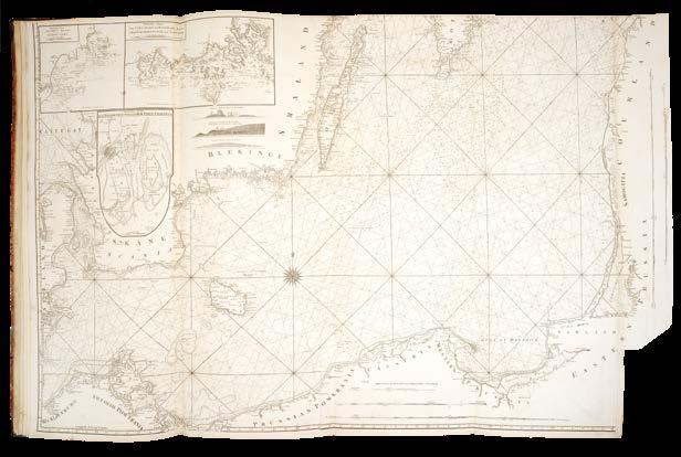
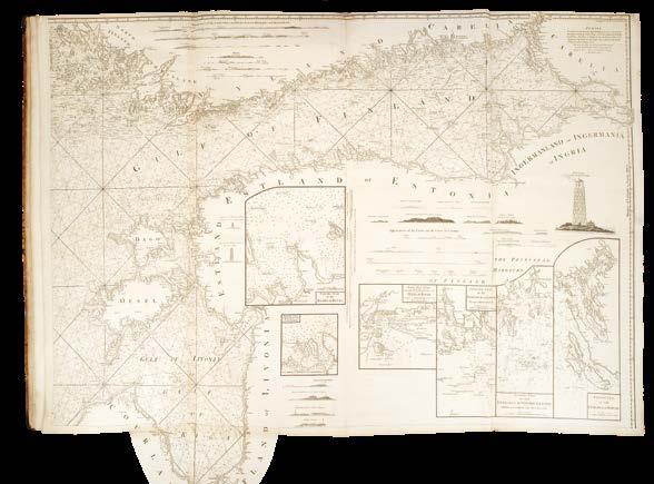
The final chart, ‘A New Hydrographic Survey of the Baltic or East Sea’ is extremely large, being bound as four sheets each of two joined sheets. The extremely large title cartouche – impressively surrounded by towering mountains, pine forests and dolphins – states that it was “made by order of Gustavus III. King of Sweden, under the direction of Vice Admiral Nordenankar, and published at Stockholm in the years 1788 and 1789 … republished by Laurie & Whittle … with several additions, from the draughts, journals &ca. of British Navigators to 1809”.
Rare: we have only been able to trace one institutional example, held by the British Library.
LAURIE, Robert; and James WHITTLE
Laurie and Whittle’s Pilot for the Eastern Coasts of Great Britain.
Publication
London, printed for Robert Laurie and James Whittle, chart-sellers to the Admiralty, &c. &c. No. 53, Fleet Street, 1810.
Description Tall narrow folio (735 by 275mm). Six large folding engraved maps, mounted dos-a-dos, final chart with engraved inset map of the Pentland Frith [sic] pasted to north-east corner, a number of repairs along creasefolds, final map with short split along central creasefold, without loss, browned and offset throughout; original publishers paper-backed blue wrappers, large letterpress paper label on upper cover with price altered in ink manuscript from £1/5/to £1/11/6, light uneven soiling to covers.
The North Sea
A classic example of Laurie and Whittle’s publishing practice inherited from Robert Sayer, whereby they reissued old titles with new charts. In this case, although chart four is dated 1794, and the final chart 1806, the others are either 1809 or 1810, bringing it right up-to-date.
Assuming the label with the original price of £1/5/- dates to 1794, then the manuscript change in price suggests that Laurie and Whittle’s prices may have fallen relative to inflation over time. Between 1794 and 1810, Britain suffered some substantial price fluctuations and overall inflationary trends due to the Napoleonic Wars. In 1794, the inflation rate was 8.97%, with the highest inflation rate during this period occurring in 1800, reaching an astounding 36.36%. There was volatility, with 1797 seeing deflation of some 10%. However, the overall cumulative effect was that over this 16 year period, Britain saw a total inflationary increase of about 69.41%. The manuscript price of £1/11/6 suggests a 26% price increase, well below the national average for the period, so it might be said that Laurie and Whittle’s atlases were effectively becoming cheaper over time.
LAURIE, Robert; and James WHITTLE
The Atlantic Pilot.
Publication
London, Printed and published by Robert Laurie and James Whittle, chart-sellers to the Admiralty, &c. &c. No. 53, Fleet Street, 1810 [but 1811].
Description
Folio (545 by 380mm). Ten engraved charts, of which six folding, three double-page and one single-page, all numbered by ink stencil, a fine clean copy with only occasional faint offsetting and light finger-soiling confined to margins, contemporary half calf over marbled-paper covered boards, expertly rebacked to style, extremities faintly rubbed.
A fine, clean example of this extremely rare pilot. Unlike ‘A Pilot for the Greenland Whale Fishery’ (1802), this pilot contains much more up-todate and accurate charts. After an apprenticeship under the nautical publisher David Steel, John Purdy (1773-1843) was recruited by Laurie into the firm in 1805. Among his first signed charts was a large, detailed chart of the North Sea (1806), and from this he was to become responsible for the vast majority of Laurie and Whittle’s hydrographic output for almost 40 years.
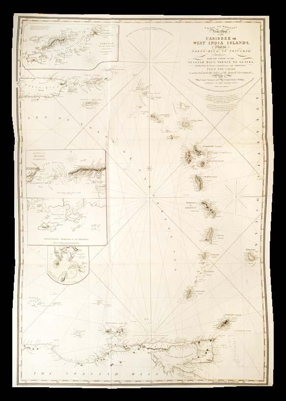
This volume includes two large and beautifully executed charts by Purdy that replaced older variants, namely the fifth chart, ‘New Chart of the Cape Verde Islands’ (1809), and the tenth, ‘New Chart of the Caribbee or West India Islands’ (1810). Also updated in this volume are chart four, the folding ‘New Chart of the Azores’, originally dated 12 June 1807, but now the “Second edition, with additions 1811”, while the sixth chart of Bermuda, based on a survey by Lempriere, is now labelled “A new edition, considerably improved” and dated 1 January 1810.
The large general folding ‘A New General Chart of the West Indies from the several surveys, made and regulated by Captn. N. Holland, Captn. B. Romans, &c. &c. … improved to 1 January 1802’ is bound seventh. This very fine chart also appears as the first general chart in ‘A Collection of Accurate Hydrogaphic [sic] Plans’ (1810), and is a late iteration of previous Robert Sayer charts. The Floridian peninsula is here extensively remodelled, and the Bahamas completely revised.
We have only been able to trace one institutional example, held by the British Library.
LAURIE, Robert; and James WHITTLE
A Collection of Accurate Hydrogaphic [sic] Plans, on a large scale, of the principal ports, bays, roads, and harbours, in the WestIndies.
Publication London, Printed and published by Robert Laurie and James Whittle, map, chart, and print, sellers, no. 53, Fleet Street, 1810 [but c.1816].
Description
Folio (530 by 370mm). Two unsigned letterpress leaves comprising title and contents, large folding engraved general chart, 40 plans on 20 sheets, faint damp stain to upper corners, mostly in blank corners, occasionally encroaching on images, offsetting to general chart and blank versos, original publishers paper-backed blue wrappers, large letterpress paper label to upper cover, decorative border, rebacked, preserving portions of original backstrip, small repair to lower cover.
References Cf. Phillips [Atlases], 2702-2703.
Extremely rare atlas of charts of bays, harbours, and ports published at the height of the Napoleonic Wars reflecting the demand of British commercial interests - particularly in sugar, coffee, and enslaved labour – for accurate and reliable charts for safe passage to ports such as Kingston, Havana, and Port Royal.
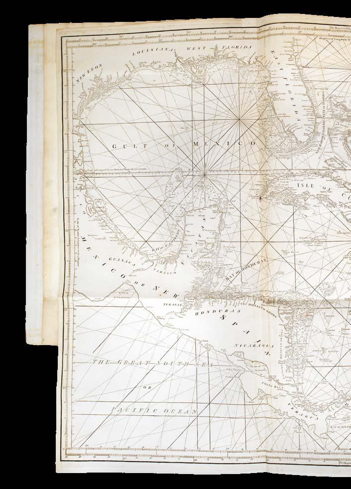
The large general folding chart bound in at the beginning of the atlas is ‘A New General Chart of the West Indies from the several surveys, made and regulated by Captn. N. Holland, Captn. B. Romans, &c. &c. and corrected from the Spanish survey of the Antillas, publish’d in 1799 … improved to 1 January 1802’. This very fine chart also appears as the seventh chart in ‘The Atlantic Pilot’ (1811 - see item 227) and is a late iteration of previous Robert Sayer charts. The Floridian peninsula is here extensively remodelled, and the Bahamas completely revised.
Bernard Romans (c.1720-1784) was a cartographer, naturalist, revolutionary, and explorer. Romans’s legacy rests on his groundbreaking ‘A Concise Natural History of East and West Florida’ (1775) and his meticulously detailed coastal charts, which redefined navigation and territorial claims in the contested landscapes of the colonial South. Born in Delft c.1720, Romans migrated first to Great Britain and then to British North America, arriving around 1757 during the tumult of the Seven Years’ War. His early career oscillated between merchant shipping and privateering, exposing him to the Caribbean’s treacherous waters. A pivotal moment came in the 1760s when he lost both his ship and fortune to Florida’s coral reefs - a disaster that forced his transition from seafaring to surveying. In 1766, he was appointed deputy surveyor of Georgia, and began systematic surveys of the southeastern coastline. His 1769-1771 expeditions along East Florida’s littoral - from St. Augustine to Pensacola - produced the first accurate charts of Mobile Bay and the Florida Keys, and engravings of his ‘A plan of Mobile Bar’ and ‘Plan of the Harbour of Pensacola’ appear as plates 15 and 16 respectively in the current work.
Extremely rare: we have only been able to trace two institutional examples, held by the British Library and the Huntington, and we have not been able to trace a single example to have appeared at auction. Both the BL and Huntington examples appear to collate the same as the present work, although Sabin 14369 calls for 21 maps. All give the publication date as 1810 as per the title imprint, but two plates of the Cuban ‘Plan of Guantanamo’ and ‘The Harbour of St. Yago’ (29 and 30 respectively) are dated 12 August 1816. The spelling mistake on the title does not seem to have been repeated in the library or bibliography entries.
HUDDART, Joseph
A Coasting Pilot for the western seas of Great Britain.
Publication
London, Robert Laurie and James Whittle, 1811 [but 1813].
Description
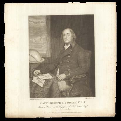
Tall narrow folio (825 by 310mm). Five engraved folding maps, including two with extension flaps, engraved portrait of Captain Joseph Huddart by John Stow after John Hoppner loosely inserted, final map with short tear at fore-edge just into borders, occasional faint soiling and offsetting, but otherwise a fine, crisp unsophisticated copy, original publisher’s paper-backed blue wrappers, large letterpress paper label to upper cover, very short splits at head and tail of spine, extremities faintly rubbed.
The western seas
A comparison between this atlas and the one under the same title, but with the earlier date of 1802 (see item 220), reveals that the two works are very nearly the same age, despite the proclaimed nine-years difference.
This “New and Improved Edition” has the first chart corrected to 1812, whereas that in “1802” edition is dated 1809, and the fourth chart is the same in both editions, being dated 1810. This “1811” edition has the second chart in an edition dated 1813. However, this edition does not have a fifth chart of the Faroe, Shetland, and Orkney Islands that appears in the slightly earlier edition. This latter is dated 1797, and presumably there was no updated chart – or at least none available – that could be added to this atlas.
This seems to have been expediency on the part of the publishers, who continued to maintain a publishing policy inherited from Robert Sayer, by which atlases of bound up charts, but without text, could be economically and speedily brought to market with great flexibility.
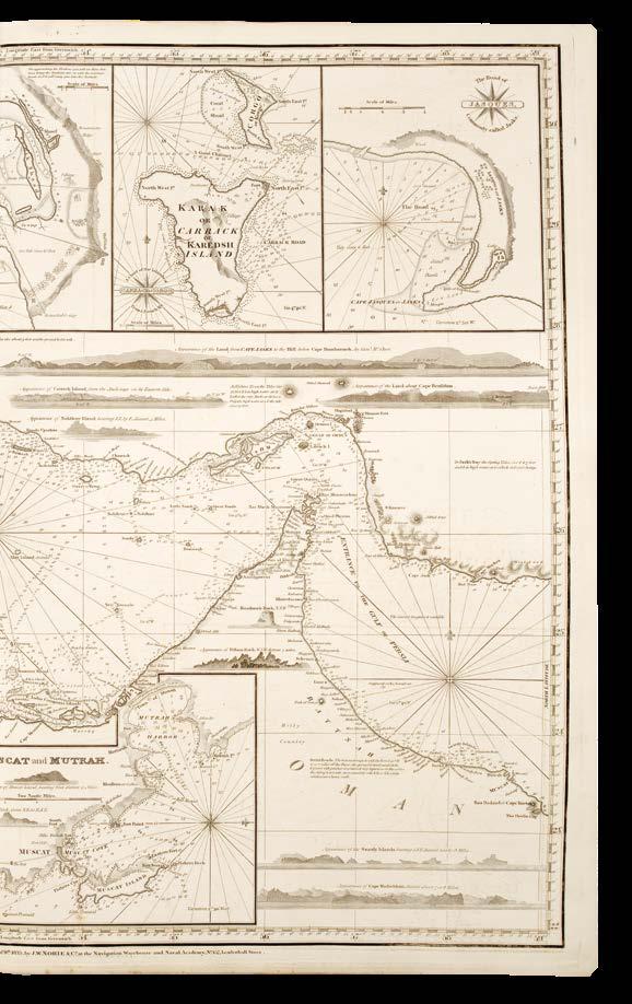
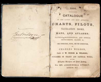
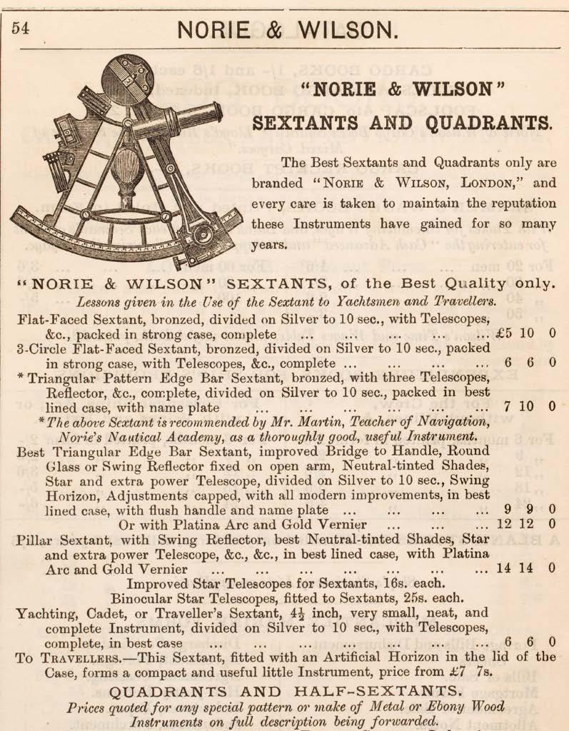
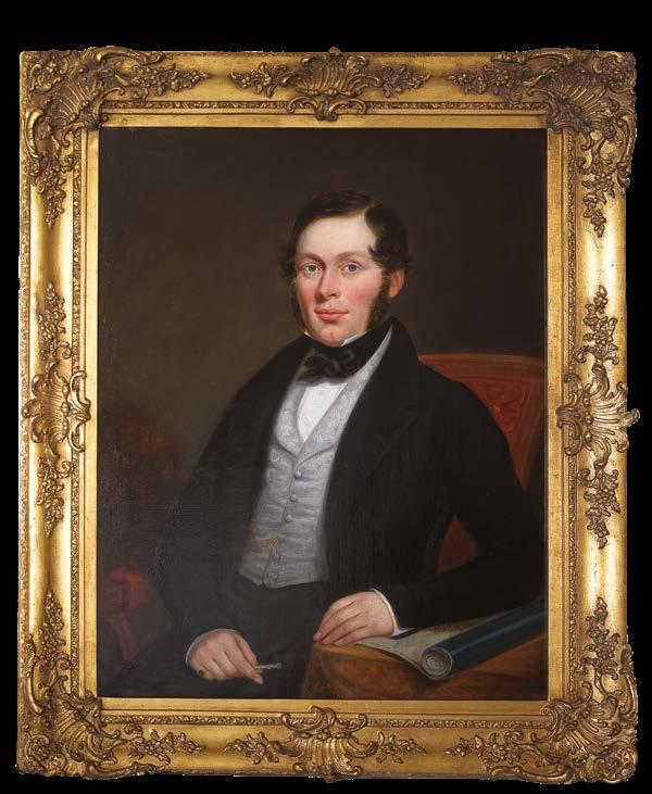
WILSON, Charles (1807-1882, senior)
The Country Trade, or Free Mariners’ Pilot.
Publication
London, Printed for, and published by, Charles Wilson, (Late J. W. Norie & Wilson,) Chartseller to the Admiralty, The Honourable East India Company, and Corporation of Trinity House, at his Navigation Warehouse and Naval Academy, No. 157, Leadenhall Street, Near The Royal Exchange, 1841.
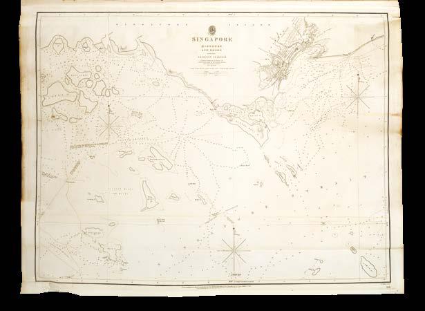
Description Elephant folio (680 by 460mm). Two unsigned leaves of letterpress text comprising title-page and contents, 24 engraved charts on 35 sheets (only, of 28, lacking the chart of Cape of Good Hope to Madagascar, chart of the Red Sea, one chart of the three-chart ‘A New Chart of the China Sea and East India Archipelago’, and the chart of the Straits of Malacca and Singapore), all but one folding, first chart trimmed close, just touching a few numerals, and mounted on linen, one chart with large tear into image, without loss, a few minor tears, some light soiling and offsetting, contemporary half russia over cloth-covered boards.
Extremely rare, seemingly unrecorded in the cartobibliographies and institutional holdings.
William Heather’s cartographic publishing business was acquired by John Norie and George Wilson in June 1813, with Norie supplying one-quarter of the capital, and Wilson three-quarters. Wilson never exercised his right to add his name to the business, and to all intents and purposes, left the running of the firm to Norie under the name of John William Norie and Co. The end of the Napoleonic Wars saw a surge in merchant shipping, and Norie took advantage to supply this growing market. In turn, this success made Norie and Wilson look for other business opportunities, one of which was the formerly prestigious chart publishers Steel and Goddard.
David Steel founded his business in the 1780s, but after his death in 1799, there were frequent changes in management and his former success started to tail off. Steel, under the direction of Stanley Goddard, had sought to stave off its misfortunes by publishing a new ‘East India Pilot’ which included charts by the East India Company hydrographer James Horsburgh, and also “Goddard tried to maintain the firm’s image by claiming to still be ‘chart sellers to the Admiralty’” (Fisher, p.89). This latter would probably have resulted in a law suit if Goddard hadn’t been declared bankrupt in 1819, which provided the opportunity for Norie to acquire the remains of the firm. Fisher notes that Norie continued to bring out new editions of many of the charts using Steel’s plates (p.91), and the present work, although a production from the 1840s, reuses old charts in a similar manner to Steel.
By the time the present work was published J.W. Norie and Co. had passed to Charles Wilson senior (1807-1882), with Fisher noting that Charles Wilson was “extremely conservative, reputedly making no changes at all in the business during the thirty-five years he was in charge” (p.99). It therefore makes sense that this atlas contains five charts by other publishers, including two Admiralty charts (numbers 16 and 17), and three charts published by James Horsburgh (numbers 19, 22, and 23) in a similar style to that of Steel’s output.
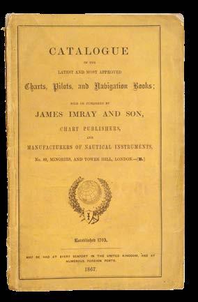
IMRAY & SON, James
Mediterranean Pilot [thus titled on spine] – Charts showing the Navigation from England to the Black Sea [thus titled on front cover label].
Publication London, James Imray and Son, [c.1846, but possibly 1866 or later].
Description Elephant folio (675 by 455mm). 7 engraved charts on 14 sheets (only, of 17, lacking 2 sheets of the English Channel and the western sheet of the Mediterranean; perhaps also lacking a title?) of which nine are folding and four double-page, some occasional light soiling, spotting, and offsetting, contemporary half-calf over marbled paper-covered boards, letterpress paper label to upper cover, with description of charts in ink manuscript, flat spine ruled in gilt in six compartments, the second lettered “Mediterranean Pilot” in gilt.
A Mediterranean pilot
The label to upper cover reads: “Exhibition of Navigational Instruments used during the Victorian Era and Earlier. James Imray & Son, 89, Minories, London. [Established 1763.] Class I. – Sect. A”, to which is added in ink manuscript below: “Charts showing the Navigation from England to the Black Sea. Published [this printed] 1835 & corrected to 1846”.
The charts in the volume are dated to 1846, and it is possible that the atlas was then bound. If so, the label is a later addition: a terminus post quem can be determined by the label’s claim that James Imray and Son was “Established 1763” which Fisher states was first used by the firm in 1866 (p.43). However, it may be even later, since the label is suggestive that the atlas was shown at the Victorian Era Exhibition of 1897. This was a celebration of the sixtieth anniversary of Queen Victoria’s accession to the throne in the style of the Great Exhibition held 47 years earlier in 1851. However, scrutiny of the exhibition programmes does not reveal there to have been a display of navigational instruments. That said, such instruments were certainly on display within the science section, so although no cartographic publishers are listed in the schedule, it is possible that James Imray and Son did present this atlas at this event. The fact that the label is printed suggests other such atlases and charts were on display too, but again sadly no evidence has survived to indicate to what extent the publishers were exhibiting their works.
IMRAY,
James (1803-1870, senior)
The New and Complete East-India Pilot.
Publication
London, Published by Jas. Imray late Blachford & Imray, 102 Minories, [c.1857].
Description
Elephant folio (680 by 445mm). Large letterpress contents leaf with price of £6/10/0 mounted on front paste-down, engraved title-page, 18 engraved charts on 27 sheets, of which 20 folding and 5 doublepaged, office copy of chart 21 mounted on linen, with large areas annotated with grid in pencil and red ink, two longitude and latitude numerals added in red ink, a few old repaired tears without loss, trimmed at southern edge with loss of border, occasional faint scattered spotting throughout, heavier to title-page and sheet 27, some offsetting, a few nicks and tears, all edges yellow, contemporary red half-roan over cloth-covered boards, expertly rebacked to style, corner repaired.
This atlas is illustrative of the type of publishing practices that existed in the nineteenth century. The title-page, although undated, can be pinned down to between 1850, when James Imray moved the firm to 102 Minories, and 1854 when the firm’s trading name changed to James Imray & Son when Imray’s son, James Frederick Imray, was promoted to a partnership in the book and instruments side of the business. However, six of the charts sport dates between 1855-1857, indicating that Imray was reusing old title-pages that were conveniently undated. The atlas itself is also composite, containing Admiralty charts, as well as those by James Horsburgh of the East India Company.
This is probably the office copy, with the chart, ‘A trigonometrical survey of the entrance to the Red Sea’, by S.B. Haines, and dated 1835, linen-backed, and with a pencil and red ink grid added. Its composite nature is suggestive of the greatly increased demand for charts of the eastern shipping routes at this time.
From the mid-1830s, when the East India Company lost its monopoly, and during the subsequent decades when the Company’s commercial and political powers waned, British merchant shipping to the east boomed. The Opium Wars (1839-1842, 1856-1860) and the opening of Chinese ports under the Treaty of Nanking (1842) intensified commercial traffic, while the discovery of tea, silk, and spice markets necessitated safer and more efficient navigation through treacherous waters. Accurate charts were indispensable, and by the time the Admiralty took over the East India Company’s chart publications in 1860, James Imray had become the main supplier of charts for merchant ships on eastern routes.
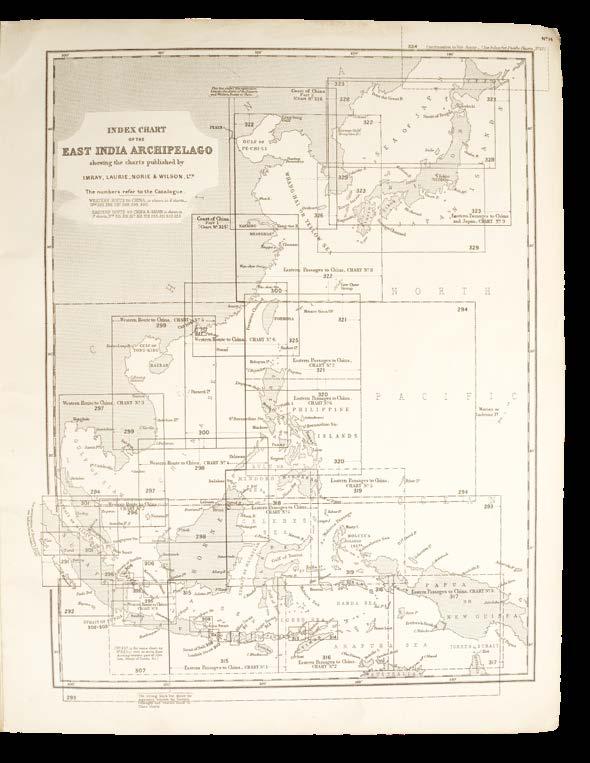
IMRAY, LAURIE, NORIE & WILSON, LTD.
Index Plans of Charts.
Publication [c1920].
Description Folio (460 by 355mm). 15 engraved charts, chart eight with pencil annotations, chart nine with ink spot in blank area; later limp blue cloth.
Inter-war atlas of index maps with individual chart numbers crossreferencing charts in the firm’s catalogue.
The firm of Imray, Laurie, Norie & Wilson, Ltd. came into existence at the turn of the century. In 1899 Norie & Wilson joined James Imray & Son, and in 1903 this firm combined with R. H. Laurie to form the present business. Their premises were at 156, Minories, previously the premises of Norie & Wilson, until 1924 when they moved to 123 Minories, where they continued until the Second World War. Since then the firm’s offices have been at Wych House, St. Ives, Huntingdon.
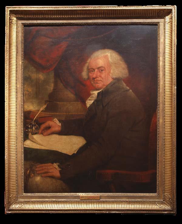
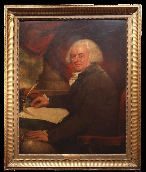
MULLER, Robert
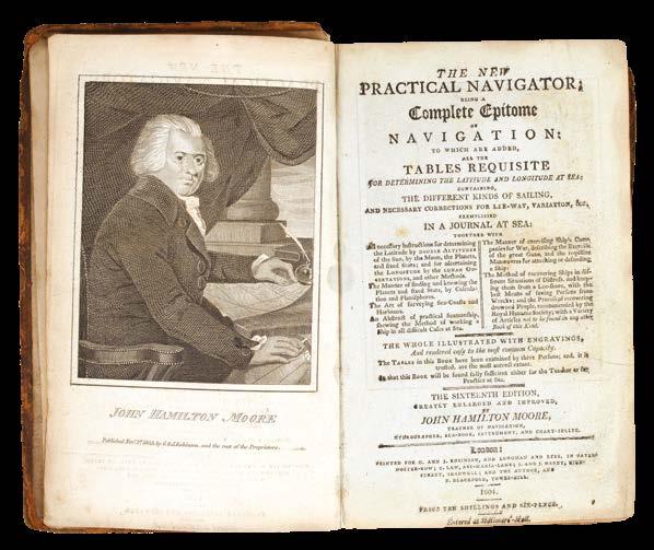
[Portrait of John Hamilton Moore].
Publication [c.1793].
Description Oil on canvas.
Dimensions
1350 by 1120mm (53.25 by 44 inches).
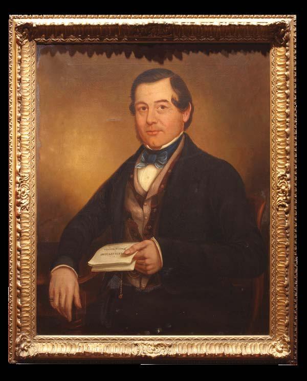
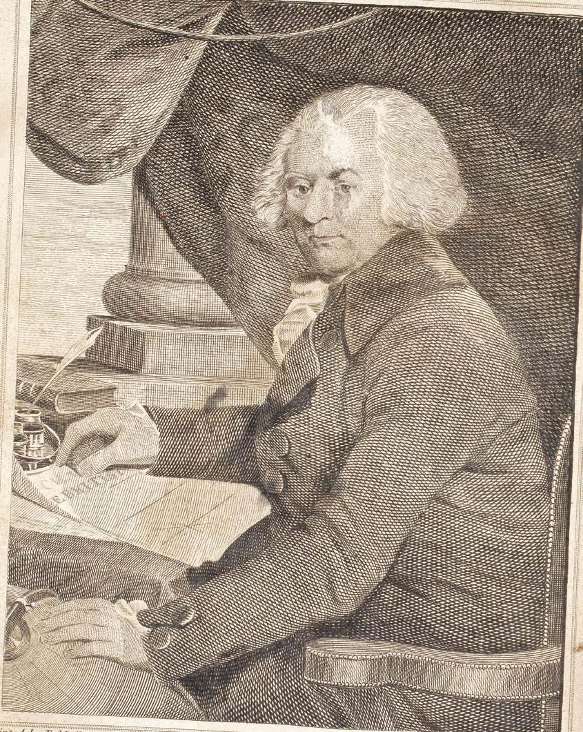
“having a propensity for genius”
A striking portrait of the chartmaker and publisher, John Hamilton Moore, by the English painter Robert Muller.
Moore sits at his desk with his head turned towards the viewer; his right arm rests on ‘A Chart of the British Channel’, one of his most successful works. Moore claimed to have sold upwards of 5,000 copies. With his left hand he touches a globe. To the table is a book, most likely ‘The Practical Navigator’, which went through some 18 editions between 1772 and the early-nineteenth century, together with several American editions.
Muller’s painting would be issued as print, engraved by Joseph Baker (1765-1853), and used as the frontispiece for later editions of ‘The Practical Navigator’.
Robert Muller (1773-c.1800) was an English portrait painter. His sitters included George Washington (after John Trumbull), Elizabeth Baldwin (wife of Thomas Baldwin, surveyor to the city of Bath), and Prince Edward, Duke of Kent.
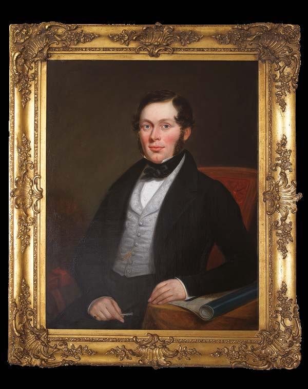
[ANONYMOUS]
[Portrait of John William Norie].
Publication [c.1805].
Description Oil on canvas, unsigned.
Dimensions (frame) 1150 by 950mm (45.25 by 37.5 inches); (canvas) 920 by 750mm (36.25 by 29.5 inches).
Master Norie the Draughtsman
A portrait of the hydrographer and chartmaker, John William Norie, as a young man.
Norie is seated with his left arm resting on a blueback chart of South America. In his right hand is a silver propelling pencil, the tool of the chartmaker and draughtsman, a position he had occupied under William Heather from 1795.
[ANONYMOUS]
Portrait of John William Norie].
Publication [c.1820].
Description Oil on canvas, unsigned.
Dimensions (frame) 900 by 775mm (35.5 by 30.5 inches); (canvas) 755 by 625mm (29.75 by 24.5 inches).
Mister Norie the Publisher
Fine portrait of John William Norie. Norie is seated, his right arm resting on his desk; in his left hand he holds a manuscript of ‘A Complete Epitome of Practical Navigation’, first published in 1805, and among his most famous, and popular works.
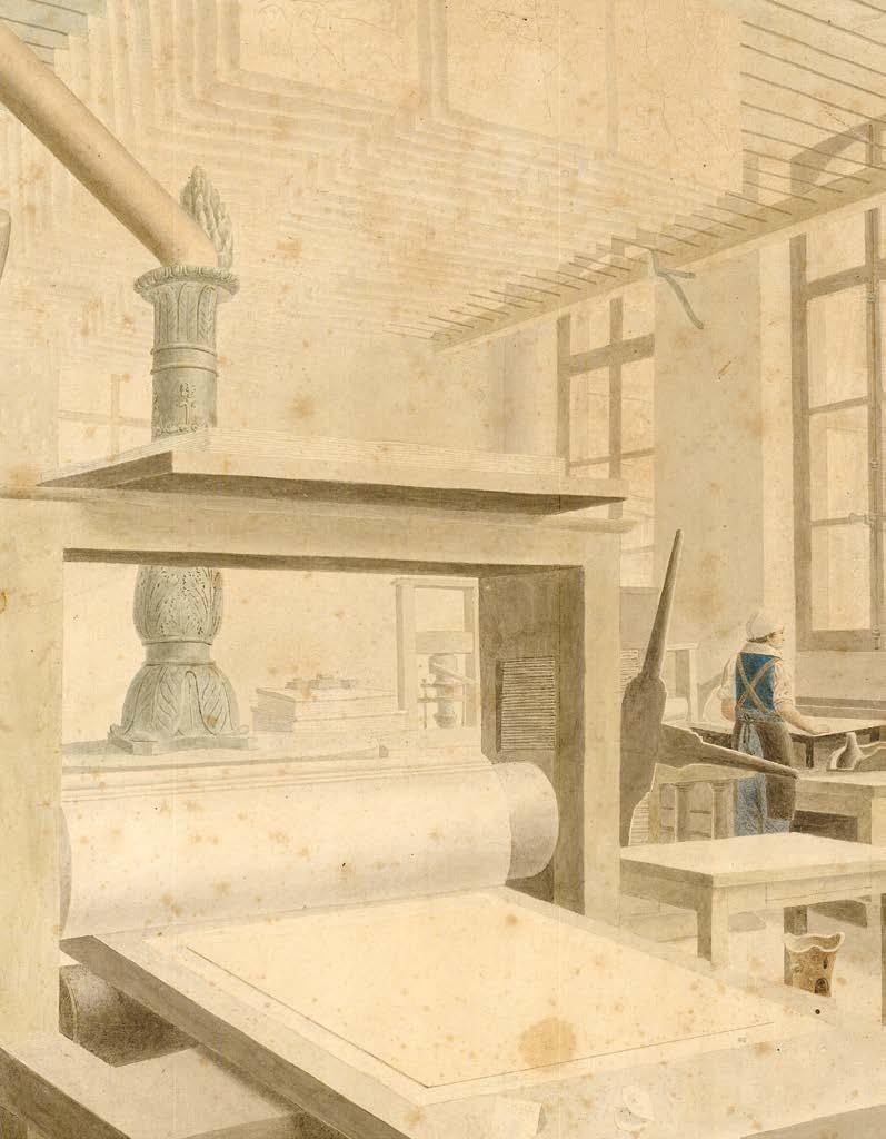
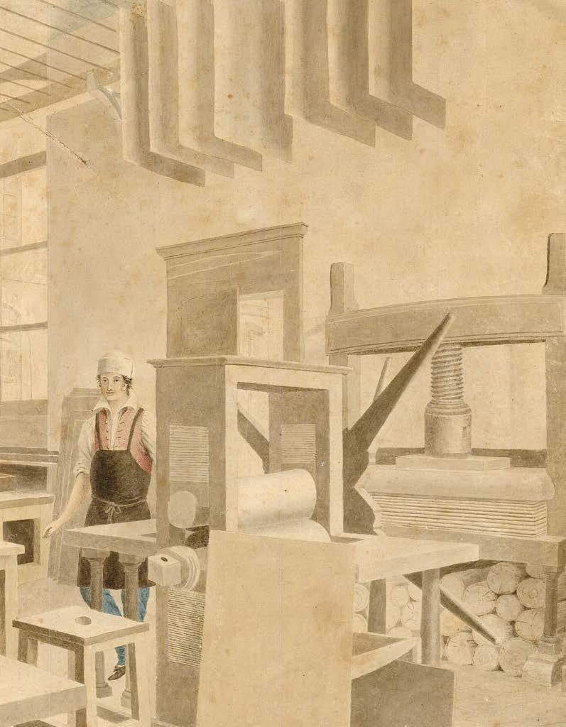
[WALKER, George, attributed]
[A Map Printer’s Factory].
Publication [c.1814].
Description Pencil and watercolour.
Dimensions
292 by 390mm (11.5 by 15.25 inches).
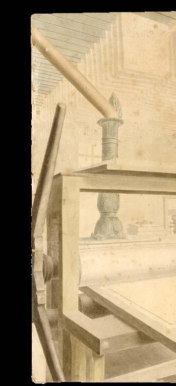
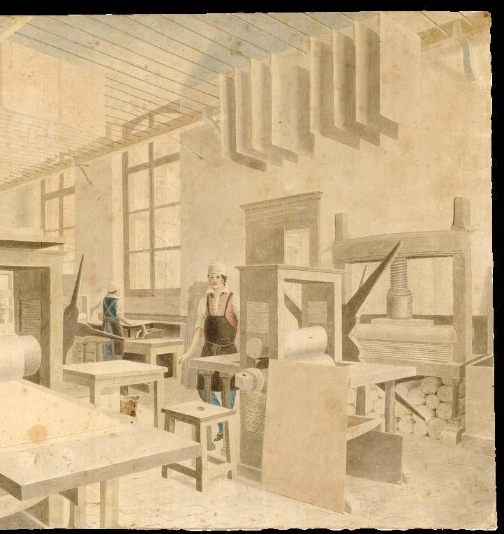
The Makers of the Blueback Charts
The image depicts map printers working two eighteenth-century geared roller copper plate printing presses, with printed charts arrayed over drying racks above.
[ANONYMOUS]
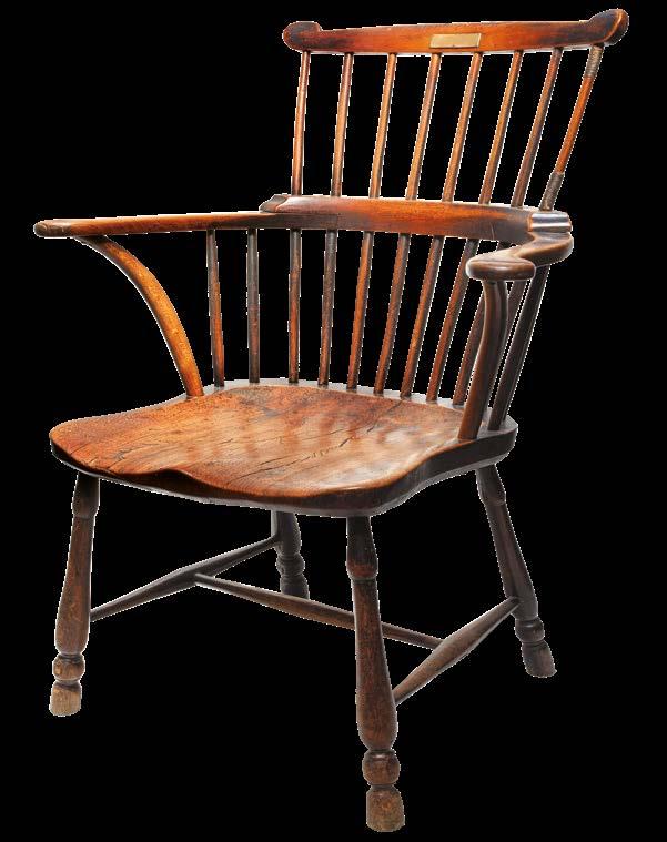
[Comb-back Windsor chair].
Publication [c.1784].
Description
?Elm seat and oak back, engraved brass plate, together with blue morocco label, lettered in gilt, repeating the words on the brass plate.
Dimensions 970 by 630 by 500mm (38 by 24.75 by 19.75 inches).
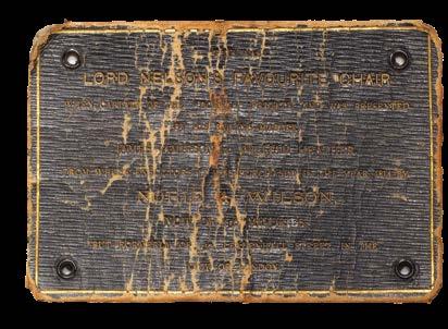
Nelson’s
Lord Nelson’s favourite chair, from his time as captain of HMS ‘Boreas’.
The text to the brass plate reads: “This was Nelson’s favour Chair when he was Captain of the Boreas Frigate, presented by his Master James Jamieson to W. Heather, being part of the property purchased by J. W. Norie and Wilson, in Leadenhall St., London”.
HMS ‘Boreas’ was a 28-gun frigate, first commissioned in 1775, and under the command of Lord Nelson between 1784 and 1787. Nelson sailed her to the West Indies, tasked with enforcing the Navigation Acts, which, in theory, prohibited trade between the US and the West Indies, and, in practice, were frequently circumvented. The success of Nelson’s voyage would be mixed: while it was during this time that he met the woman who would become his wife, Frances Nisbet, the tenacity with which he approached the application of the Navigation Acts made him few friends, and morale on the ship was frequently low, with almost half the men on board flogged for mutinous behaviour and attempts to desert.
The chair passed from James Jamieson (also known as “Old Jemmy Jamieson”), who had been the sailing master of the ‘Boreas’, to William Heather, a close friend of Jamieson, whose maritime expertise served as a valuable source for Heather’s charts, and then to John Norie and George Wilson, who, in 1814, bought the chair from Heather’s executors.
A trade card to inspire Dickens
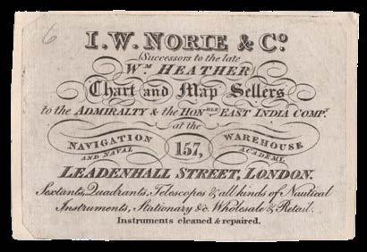
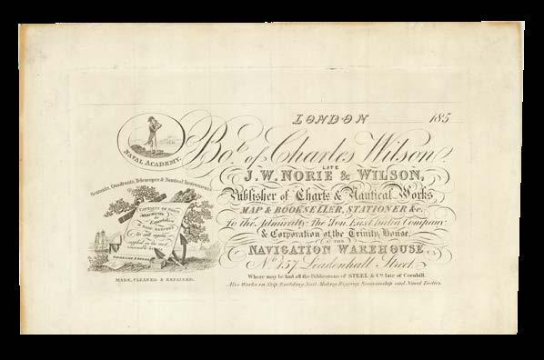
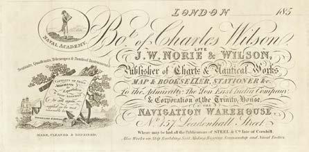
NORIE, J[ohn] W[illiam]
I.W. Nories & Co (Sucessors to the late Wm. Heather) Chart and Map Sellers to the Admiralty & the Honble. East India Compy... Sextants, quadrants, telescopes & all kinds of nautical instruments, stationary &c. Wholesale & Retail. Instruments cleaned & repaired.
Publication London, at the Navigation Warehouse and Naval Academy, 157 Leadenhall Street, [1824-1840].
Description Engraved trade card, mounted on card.
Dimensions 150 by 680mm (6 by 26.75 inches).
References
Kemp, ‘Some Notes on the Ward of Aldgate and Its Ancient & Modern History’, (Eden Fisher, 1904); Worms, Baynton-Williams, ‘British Map Engravers’, (London Rare Book Society, 2011); Robinson, ‘The artistic trade cards of the nautical instrument makers’, (The Mariner’s Mirror, 1911).
John Norie (1772-1843) took over the Navigation Warehouse and Naval Academy in Leadenhall Street in 1813, having previously compiled and published ‘A New and Complete Epitome of Practical Navigation’. This volume was dedicated to the Court of Directors at the East India Company, an act of flattery that paid off when he became an official chartseller to the Company in 1824. Alongside a great number of maps and charts, Norie sold a wide range of nautical instruments, including “sextants, quadrants [and] telescopes”, as stated on his trade card. Worms notes that globes were also available at the Navigation Warehouse, as well as sets of nautical tables, and that Norie operated from an additional property at 70 Cornhill from 1829. Furthermore, the 1834 electoral registers show that, besides these shops, he also had property by Regent’s Park, and in Edinburgh. The present trade card was in circulation from the beginning of Norie’s contract with the East India Company until his retirement in 1840.
In the era before reliable street numbers or any widespread advertising media, the trade card had been a crucial means of publicizing the name and location of one’s business. Even after the development of more sophisticated systems, they continued to be a popular way of communicating with potential customers, and most merchants or shopowners of the eighteenth century had some form of trading card. The map and navigation industry was no exception, and Robinson notes that “in the case of nautical instrument makers, [the cards] were fixed in the boxes containing quadrants, compasses or other articles sold by the firm”. He goes on to explain that the same design “frequently appeared as a bill-head on invoices, delivery notes, and similar documents” and that “in those days, every merchant’s shop had its distinctive sign, and this was naturally a prominent feature in the trade card”. Although Robinson uses Norie as a direct example of this iconography, there is no distinctive sign or symbol to be found on the present card, perhaps suggesting that he may have had another in circulation.
The specific sign Robinson assigns to Norie is that of the ‘Little Midshipman’, which is also referenced by Kemp and Worms. This small figure had adorned the doorway of 157 Leadenhall Street throughout Norie’s occupancy, and was immortalized by Charles Dickens in his 1846 novel, ‘Dombey & Son’. The work centres around the eponymous shipping firm, and features a nautical instrument maker, Mr Soloman Hills, who operates “under the sign of the Little Midshipman”. In his characteristic style, Dickens satirizes Norie’s Navigation Warehouse, describing its sign as one of the “little timber midshipmen in obsolete naval uniforms, eternally employed outside the shopdoors of nautical instrument-makers in taking observations of the hackney coaches”.
Although commonplace at the time, the nature of Norie’s trade card meant that it was frequently handled, and therefore often damaged or lost, making the present example a rare survival.
WILSON, Charles Bot of Charles Wilson
Late J.W. Norie & Wilson, Publisher of Charts & Nautical Works Map & Bookseller, Stationer &c. To the Admiralty: The Hon. East India Company: & Corporation of the Trinity House, at the Navigation Warehouse, no. 157 Leadenhall Street.
Trade card for Charles Wilson, who took over J.W. Norie & Co in the late-1830s.
Wilson advertises himself as a “Publisher of Charts & Nautical Works, Map & Bookseller, Stationer &c. To the Admiralty: The Hon. East India Company: & Corporation of the Trinity House”. His breadth of stock is such as to meet all one’s nautical needs: from “Sextants, Quadrants, Telescopes & Nautical Instruments”, to “all the Publications of Steel & Co. late of Cornhill” and “Works on Ship Building, Sail Making, Rigging, Seamanship and Naval Tactics”.
Top-left is a vignette of a sailor, looking out to sea through a quadrant, a representation of the famous ‘Little Wooden Midshipman’ shop sign, which stood outside the 157 Leadenhall Street premises (also referred to as the “Naval Academy” and the “Navigation Warehouse”), and which is traditionally thought to have served as Charles Dickens’s inspiration for the shop sign that appears outside the premises of Sol Gill’s chart shop, in ‘Dombey & Son’.
Bottom-left is an elaborate cartouche, surrounded by a telescope, a globe, a ship, and an anchor, which notes that Wilson’s stock was “supplied on the most reasonable terms”, both “wholesale & retail” to a varied clientele (“Captains of Ships”, “Merchants for Exportation”, and “Shop Keepers to sell again”).
Wilson refers to his business as “Charles Wilson. Late J.W. Norie & Wilson”, something of a misnomer, given that Norie and George Wilson (both senior and junior), from whom Wilson had inherited the business, only ever traded as “J.W. Norie & Co”. It serves, however, as a shrewd attempt to establish Wilson’s credentials.
MOORE, John Hamilton
The new Practical Navigator: being an epitome of navigation; The thirteenth edition, constructed on a new plan, and illustrated with copper-plates.
Publication London, Printed for and sold by B. Law … G.G. and J. Robinson, and the author, 1789.
Description Octavo-in-4s (210 by 125mm). Engraved frontispiece and eight plates, lacking leaf 2C4, staining, soiling and dogearing throughout, contemporary calf.
Dimensions 210 by 125mm (8.25 by 5 inches).
References Alexander, Isabella, ‘Sayer v. Moore (1785)’, in Jose Bellido, Ed., ‘Landmark Cases in Intellectual Property Law, Ch 3’, Hart Publishing, 2017; Skelton, R.A., ‘Copyright and Piracy in Eighteenth Century Chart Publication’, 1960, in 46 The Mariner’s Mirror 207; Alexander et al, ‘Copyright and Cartography’, https://www. copyrightcartography.org/cases/steelv-moore-heather-v-moore/ (accessed 1 March 2025).
J.W. Norie’s Copy
Includes a two-page report of Moore’s successful court cases with Sayer & Bennett in 1785 and with Steel in 1789.
John Hamilton Moore (1738-1807) Scottish teacher of navigation, publisher of blueback charts, and founder of the firm that would become Imray, Laurie, Norie, and Wilson, had to defend himself on three occasions against accusations of plagiarism.
Sayer vs Moore (1785)
Moore’s “first venture into chart publishing produced an immediate response from Robert Sayer and John Bennett, the leading chart publishers of the day, who sued him for £10,000 for his 1784 Chart of North America which they claimed infringed their copyright” (Fisher). They claimed that Moore had simply combined their charts into a single, larger map. At the King’s Bench before “a ‘special jury’ consisting of merchants with expertise in navigational charts and maps, witnesses for Sayer testified that he had expended considerable labour and expense in producing his charts. One witness for Sayer even gave evidence that he had been commissioned by Moore to make copies of Sayer’s charts. On the other hand, Moore was able to produce expert evidence that his maps were a significant improvement on Sayer’s and of greater utility to marine navigators. In other words, where Sayer had focussed on the physical act of copying as evidence of copyright infringement, Moore argued that the content of his map was a marked improvement on Sayer’s charts” (Alexander et al). Moore, who was evidently wellregarded as a chartmaker, brought eminent authorities to argue his case in the form of Captain John Stephenson, Admiral Campbell FRS, Governor of Newfoundland, and William Wales FRS, an astronomer who had sailed with Captain Cook. They all gave evidence that Sayer’s maps were both erroneous and dangerous and that Moore’s were a considerable improvement over them. The judge, Lord Mansfield, ultimately agreed with Moore and held that he had not unlawfully copied Sayer’s charts. In his judgement, Lord Mansfield made the following well-known observation:
“In deciding we must take care to guard against two extremes equally prejudicial; the one, that men of ability, who have employed their time for the service of the community, may not be deprived of their just merits, and the reward of their ingenuity and labour; the other, that the world may not be deprived of improvements, nor the progress of the arts be retarded”.
Steel vs Moore (1789)
Another rival chartmaker, David Steel, brought a further action in the King’s Bench in 1789 accusing Moore of copying two charts Steel had published in 1782. Again, Moore brought the authority of Captain John Stephenson and other expert witnesses to bear on the case, and Steel’s lawyer agreed to withdraw the action and pay Moore’s costs.
Provenance: 1. With the ink ownership inscription of J. Wood on title in a contemporary hand; 2. Very faint pencil ownership inscription of J.W. Norie on title that appears to match that in the sixteenth edition; 3. Some pencilled annotation throughout.
[MOORE, John Hamilton]
Whereas John Hamilton Moore of Tower-Hill, The pretended hydrographer to the Duke of Clarence, was seen Between the Hours of 3 and 5 last Sunday Morning, Sticking Bills about the Streets!!!
[together with:] Trial of John Hamilton Moore for pirating a chart.
Publication May 31st, 1794... [and, London], Plummer, Printer, [1798].
Description Broadside (280 by 220mm), 1p [BOUND WITH:] Octavo (207 by 130mm), 8pp, modern marbled boards.
References Alexander, Isabella, ‘Sayer v. Moore (1785)’, in Jose Bellido, Ed., ‘Landmark Cases in Intellectual Property Law, Ch 3’, Hart Publishing, 2017; Skelton, R.A., ‘Copyright and Piracy in Eighteenth Century Chart Publication’, 1960, in 46 The Mariner’s Mirror 207; Alexander et al, ‘Copyright and Cartography’, https://www. copyrightcartography.org/cases/steelv-moore-heather-v-moore/ (accessed 1 March 2025).
Chart Piracy! - The Trials of John Hamilton Moore
Apparently the only known surviving example of an anonymous, and malicious, broadside attacking the probity of John Hamilton Moore, together with a report of the case between Heather & Co. and Moore in 1801, which Moore lost.
John Hamilton Moore (1738-1807) Scottish teacher of navigation, publisher of blueback charts, and founder of the firm that would become Imray, Laurie, Norie, and Wilson, had to defend himself on three occasions against accusations of plagiarism. The trial report here relates to his third, final, and unsuccessful defence against charges brought by his former assistant, William Heather. Prior to this Moore successfully defended himself against similar accusations from the chartmakers Robert Sayer, in 1785, and David Steel, in 1789. Taken together the three cases demonstrate how: “copyright law and the determination of copyright cases formed a part of Enlightenment epistemology. This is particularly related to scientific method and approaches to the collecting, organising and storing of data, but also links to economic advancement through trade and commerce” (Alexander).
Heather vs Moore (1797)
In the third copyright infringement action against John Hamilton Moore, his former assistant, William Heather, “claimed that Moore had pirated a chart called ‘A New and Correct Chart of the Coasts of France Spain & Portugal drawn from the latest observations & surveys by William Heather’. The copyright suit followed what seems to be a falling out between Moore and Heather, as after Heather had left Moore to start his own business, Moore commenced proceedings against him alleging that Heather owed him a sum of money
... This time however, Heather (perhaps having learnt more than just the publishing trade from his former employer) produced the expert witnesses, including Captain Stephenson, who had previously appeared as a witness for Moore in the earlier cases (NB Heather subsequently published Captain Stephenson’s book, The New British Channel Pilot, in 1799). Heather argued that Moore had unlawfully copied one of his charts. Moore responded by arguing that it Heather’s map was the unlawful copy, pirated from an earlier publication released by Moore. Like Moore’s witnesses in the previous two cases, Heather’s witnesses persuaded the jury that Moore’s map contained a series of crucial errors and omissions, and that Heather’s map was far more superior and of greater utility to the navigational industry. As such, Lord Kenyon found that Moore had pirated Heather’s chart” (Alexander et al).
Moore’s enmity with his colleagues and competitors evidently spilled out beyond the courtroom as the present broadside, published in 1794 - a full nine years after his case with Sayer, and five years after his case with Steel, mentions both, and accuses Moore of “Sticking Bills
about the Streets”, “Debauching a Servant”, bribery and “innumerable instances of baseness, dissimulation, and fraud”. Sadly, the convoluted sequences of succession and merger in London’s chartmaking trade in the nineteenth century mean that it is unclear whether the survival of these two documents in the archives of Imray, Laurie, Norie and Wilson is as a result of them being retained as souvenirs of Moore’s side of the arguments or that of Sayer, or Steel, or Heather, or even, another!
Rarity
We are not aware of any other example of the broadside. Indeed, the few mentions of its existence that we have been able find all seem to refer to the present, Imray, Laurie, Norie, and Wilson example.
OCLC locates six examples of the trial report: Alberta, Boston Public Library, Georgetown, Harvard Law School, New York Public, Pennsylvania State. To this we can add a further example at the Society of the Cincinnati.
[LOG BOOK]
CAMPBELL, William
A Journal of the Proceedings in HM Ship Sceptre... H.M.S. St. Fiorenzo... [and] H.M.S. Wilhelmina.
Publication 1803-1805.
Description Folio (385 by 425mm), 230pp, incorporating 81 pen and ink mapsheets, and 29 watercolour coastal profiles, calf boards, rebacked.
The ship’s log kept by William Campbell, master’s mate, to Sumatra and back, 1803-1805, in HMS ‘Sceptre’, HMS ‘St. Fiorenzo’, and HMS ‘Wilhelmina’ with track charts and remarks.
The log gives an (often grim) insight into a sailor’s life: HMS ‘Sceptre’ lost eight souls in as many weeks at the start of the journal; seven are recorded as having“departed this life” due to “disease”, whereas poor John Wilson “fell overboard” and “all efforts to save proved ineffectual”. The dead could be expected to be “committed to the deep” within 24 hours of their passing and their “diseased artefacts sold” (November 27th 1804) the day after. For the living, however, the selling of “his cloathes” meant two dozen lashes for Argus Gurr (May 16th 1804), and one dozen for John Lyne for purchasing them. “Drunkedness” earned a relatively standard 24 lashes, as did “Uncleanliness”, and “Spoiling provisions”. Further colour is provided figuratively by the charts - the vast majority of which are blank save the slow progress of the vessels over expanse of the Indian Oceanand literally in the form of the coastal profiles. The land masses that appear on the charts are St. Helena, South America (Rio de Janeiro), The Cape of Good Hope, Madras, The Bay of Bengal, the Nicobar Islands, and the Malay coast. The coastal profiles depict St. Helena (11, including one folding); Madras (five); Pulicat Hills (six, one folding); Tenasserin (six, including one folding); and the Cocos Islands (one).
HMS ‘Sceptre’ was a 74-gun ship of the line built by Dudman of Deptford after a design by Sir William Rule, and launched in December 1802 at Deptford. She would serve for five years in the East Indies.
HMS ‘St. Fiorenzo’ (originally ‘Minerve’) was a 40-gun frigate of the French Navy, captured by the British in 1794, and recommissioned as a 38-gun fifth rate HMS ‘St. Fiorenzo’.
HMS ‘Wilhelmina’, originally a 36-gun Dutch States Navy frigate launched at Vlissingen in 1787, was taken first, by the French, in 1795, and then the British, three years later, when she was repurposed as a 21-gun troopship assigned to escort a small convoy of East Indiamen.
Norie’s own copy
MOORE, John Hamilton
The new Practical Navigator: being an epitome of navigation; The sixteenth edition, greatly enlarged and improved.
Publication
London, Printed for G. and J. Robinson, and Longman & Rees … C. Law … J. and J. Hardy and Sons … and the author, and R. Blachford, 1804.
Description
Octavo-in-4s (210 by 125mm). Engraved frontispiece, ten plates and two folding planispheres bound in at end, leaves 2B2, 2H4 (tables) and 2U2 trimmed into final line with textual loss, very small chip to fore-edge of 2I1 (Tables) with some loss; contemporary sheep.
Norie’s own copy of his great rival’s navigation guide is peppered with acerbic comments in red pencil and ink throughout. It starts on the first page, where he comments on Moore’s “simple and accurate rule for finding the time of the Moon’s rising and setting”: “This boasted Rule neither new nor accurate – see the same in the former Edition after Table XX and copied in this with many blunders – so much for improvement –”. Norie notes errors to “Wrong tables”, comments about “A stupid rule rendering an easy one complex”, and states “Complete nonsense” among other comments. In total there are 25 annotated pages, while there are quite a few crossings out to the tables, with Table XVI crossed out over four leaves with the note “No such table”, as well as further crossings out of Tables XXII and XXVIII.
Provenance: with the ownership inscription of J.W. Norie in red pencil on front pastedown with place of “Naval Academy Leadenhall Street”; further annotations in red ink.
HOBBS, J[ohn] S[tratton, and another hand]
Notebook with proposals for new charts for the firm of Norie and Wilson.
Publication 1846-1897.
Description Folio (320 by 200mm), 63pp., folio, stab bound.
Chart Planning
A marvellous survival: proposals for over 100 charts, including notes on whether or not they were accepted, date, area to be covered, paper size, margin width, meridional parts, plates ordered, and later period publication.
A manuscript proposal for a chart of the Channel pasted at the front is inscribed “Planned for Norie” and signed “J.S. Hobbs”, dated “1838-39” in pencil. This, and the majority of entries, are in the hand of Hobbs, until May 20th 1874 (Hobbs died in December that year), after which another, anonymous, hand takes over.
John Stratton Hobbs (1813-1874) was the son of William Henry Hobbs, ship broker of Globe Street, St. George in the East. Hobbs compiled charts and engraved for Norie until Norie’s death in 1843, after which he became head of the hydrographic department of the successor firm, Noire and Wilson. He was elected to the Royal Geographical Society in November 1846.
[HOBBS, John Statton]
List of meridional parts 0 - 60 degrees.
Publication [c.1850].
Description Folio (330 by 200mm), 6pp., pen and ink manuscript.
Meridional parts
A curious piece of cartographic ephemera.
The meridional parts for any latitude is the length of meridian on a chart on the Mercator Projection between the Equator and that latitude measured in units of longitude scale. The meridional parts are tabulated in nautical tables (as here). Meridional parts do not represent distance on the Mercator chart.
John Stratton Hobbs (1813-1874) was the son of William Henry Hobbs, ship broker of Globe Street, St. George in the East. Hobbs compiled charts and engraved for Norie until Norie’s death in 1843, after which he became head of the hydrographic department of the successor firm, Norie and Wilson. He was elected to the Royal Geographical Society in November 1846.
[WILSON, Charles]
[Draft valuation of copper plates].
Publication 1865.
Description Folio (390 by 245mm), 5 pp., pen and ink.
Turning copper into gold
A list of 122 copper plates, engraved with maps, with total value of £11,263, with notes on condition, whether steeled or not, and whether in need of correction.
A fascinating record of the value of engraved copper plates. The map titles broadly align with those in Wilson’s 1861 catalogue.
“Printing very faint in places”... “Recut, done”
[IMRAY, LAURIE, NORIE & WILSON LTD.]
[Log of alterations to chart plates, together with:] Notice to Mariners.
Publication 1905-1924.
Description
Folio (235 by 310mm). Printed ship’s log book, 182pp, with broadsheet ‘Notice to Mariners’ tipped in at rear, final two leaves torn, blue paper boards, restored.
A remarkable piece of mapmaking ephemera and an insight into the work required to keep the chart production of the firm of Imray, Laurie, Norie & Wilson up-to-date. The log, mostly in the hand of William Wilson, extends nearly 20 years, includes over 1000 amendments to over 200 charts, and is arranged alphabetically by chart title, with a note of revisions made with name of reviser and date.
Loosely inserted to the volume are two typed signed letters from W. Wilson to W. R. Courtney, dated February 7th and June 14th 1924 regarding his duties: “You appear to be under the impression that the Directors have given you over the unfettered direction of the Chart Department, but this is not the case”.
There is also a ‘Notice to Mariners’, listing amendments and updates to Admiralty charts by number and name, with manuscript notes providing the affected chart numbers in the inventory of Imray, Laurie, Norie & Wilson.
Very large quarto (360 by 290mm). “Beaufort’s Notation” pasted onto front pastedown, 18 leaves of unfilled log book, occasional light finger-soiling; original cloth-back boards, printed paper label on front cover, extremities rubbed, head- and tail of spine fractionally more heavily.
The firm’s office copy of the blank log book used by senior officers on board ship: “May be had from all nautical booksellers & ship chandlers.” Provenance: “Office” written in blue chinagraph pencil on label on upper cover.
SAYER, Robert
[Three catalogues of prints, charts, and maps].
Publication 1786-1788.
Description Octavo (210 by 135mm), three catalogues bound in one, interleaved, trompe l’oeuil engraved title, manuscript corrections to 1795, half calf over paper boards.
Sayer’s Office Copy of his catalogues of prints, charts and maps
The three catalogues are:
[1] Robert Sayer’s Catalogue of New and Interesting Prints... 1786. 94 pp
[2] Robert Sayer’s Catalogue of Pilots, Neptunes, and Charts... 1787. 49 pp
[3] Robert Sayer’s Atlases, both ancient and modern, Books of Maps, Surveys, and Catalogue of Single Maps... 1788. 52 pp.
Three catalogues of Robert Sayer’s offerings from 1786 to 1788, with prints divided in to various sections such as “Fine Engraved Landscapes... Large Sea Pieces, &c... Theatrical, fine Mezzotintos...”.
The ‘Catalogue of Pilots, Neptunes, and Charts’ includes (and lists the contents of):
1. The East India Pilot; or, Oriental Navigator - two volumes (111 charts)
2. The East India Pilot; or, Oriental Navigator - one volume (100 charts)
3. The Oriental Pilot;, or East-India Directory
4. The New East-India Pilot (five charts)
5. A Complete Pilot for the Northern Part of the Bay of Bengal
6. A New Edition of the Channel Pilot (25 charts)
7. The Three-Channel Pilot (seven charts)
8. A Coasting Pilot for Great Britain and Ireland (22 charts)
9. The North-About Navigator (13 charts)
10. The Irish Coasting Pilot (six charts)
11. The Coasting Pilot for Flanders, Holland, Friesland... (14 charts)
12. A Pilot for the North Sea, Baltic, Cattegat Passage of the Sound and Gulf of Finland... (seven charts - with manuscript updates to both title and contents in iron gall ink)
13. The New Mediterranean Pilot (eight charts)
14. The Straits Pilot (four charts)
15. The Guinea-Coast Pilot (seven charts)
16. The Western Neptune; or Pilot for America (ten charts)
17. The Atlantic Pilot (13 charts)
18. The Complete West-India Pilot (26 charts)
19. A Pilot for the West Indies (13 charts)
20. A small Pilot for the West-Indies (seven charts)
21. A Pilot for the Gulph of Florida, and Windward Passage (four charts)
22. Captain Bishop’s Charts of the Gulph and Windward Passages and Old Straits of Bahama.
23. Forty Accurate Draughts of the Principal Bays and Harbours on the Continent, and Islands in the West Indies (40 charts)
24. The First Part of the North-American Pilot (22 charts)
25. The Second Part of the North-American (13 charts)
And 123 separately-published charts.
Laurie & Whittle’s Office Copy of their General Catalogue of Maps, Charts, and Prints
LAURIE & WHITTLE
A General Catalogue of Maps, Charts, and Prints &c. &c. &c. &c.
Publication London, Laurie & Whittle, 1795-1800.
Description Octavo (225 by 142mm), Engraved trompe l’oeuil general title, and three catalogues bound in one, manuscript corrections and amendments throughout, modern half calf.
The three catalogues are:
[1] Laurie and Whittle’s New and Enlarged Catalogue of Pilots, Neptunes, and Single Charts... 1797, amended in manuscript to 1802. 76 pp.
[2] Laurie and Whittle’s Catalogue of new and interesting Prints... 1795, with manuscript amendments. iv, 132 pp.
[3] Laurie and Whittle’s New and Enlarged Catalogue of Atlases, Surveys and Single Maps... 1800. iv, 74 pp.
Robert Laurie and James Whittle worked with Robert Sayer and on his death in 1794 took over the business. The partnership continued until Laurie’s retirement in 1812.
The catalogue of pilots lists the following titles:
1. East India Pilot (113 charts)
2. East India Pilot (102 charts)
3. The Country Trade East-India Pilot (82 charts)
4. The Oriental Pilot (41 charts)
5. New and complete Pilot, from the mouth of the Thames to the Cape of Good Hope (24 charts)
6. Pilot of the Eastern Passage (ten charts)
7. East-India Pilot (five charts)
8. A Complete Pilot for the Northern Part of the Bay of Bengal (five charts)
9. A New East-India Directory
10. The Channel Pilot
11. Three Channel Pilot
12. The Coasting Pilot for the Western Seas of Great Britain (five charts)
13. A New Pilot for the East Coast of New England (nine charts)
14. A Large Coasting Pilot of Great Britain and Ireland (23 charts)
15. The North-about Navigator (13 charts)
16. The Irish Coasting Pilot (six charts)
17. The Coasting Pilot (15 charts)
18. A New and Enlarged Baltic Pilot (12 charts)
19. The Baltic Pilot (nine charts)
20. A new Mediterranean Pilot (eight charts)
21. The Straits Pilot (four charts)
22. The African Pilot (14 charts)
23. The Guinea Coast Pilot (six charts)
24. The West India Atlas (62 charts)
25. The Complete West India Pilot (27 charts)
26. A Pilot for the West-Indies (13 charts)
27. A small West India Pilot (eight charts)
28. Roman’s Gulf and Windward Pilot (five charts)
29. Captain Bishop’s Original Charts of the Gulf and Windward Islands (three charts)
30. Forty Accurate Plans and Draughts of the principal Ports, Bays, Roads, and Harbours, in the West Indies (40 charts)
31. The Atlantic Pilot (13 charts)
32. The First Part of the North American Pilot (five charts)
33. The Second Part of the North American Pilot (20 charts)
34. The Coasting Pilot, for North America (seven charts)
35. The Western Neptune (ten charts) and 169 separately-issued charts.
WHITTLE & LAURIE
[Three catalogues].
Publication London, James Whittle and Richard Holmes Laurie 1813-1814.
Description Octavo (235mm by 150mm), half calf marbled boards.
The three catalogues are:
[1] Catalogue of Pilots, Charts, and hydrographic with other Nautical Works... Corrected to November, 1814. 21 pp., with prices and other corrections in manuscript.
[2] [Catalogue], 6 leaves with 2 pp. ms.
[3] Catalogue of the Atlas’s, maps, prints, books of Penmanship, and miscellaneous works excepting sea-charts and hydrographic publications... Corrected to February, 1813. 26 pp., with prices and corrections in manuscript. 199 maps
Robert Laurie, who was James Whittle’s original partner in Laurie and Whittle, retired in 1812 and was succeeded by his son, Richard Holmes Laurie. The firm was then known as Whittle and Laurie until Whittle’s death in 1818.
LAURIE, R.H.
[Five catalogues of charts and maps].
Publication 1821-1825.
Description Octavo (210 by 132mm), half calf, marbled boards, interleaved, with manuscript notes.
R.H.
Laurie’s Office Copy of their Catalogues of 1821-1825
The catalogues are:
[1] Catalogue of the Pilots, Charts, and other nautical works... 1825. 16 pp. 351 products
[2] Catalogue of Pilots, Charts, and other nautical works... 1821. [2, advert] 19 pp. (383 products)
[3] Catalogue of Atlasses[sic] and Maps... 1824. 17 pp. (291)
[4] Catalogue of Atlasses[sic] and Maps... 1822. 17 pp. (289)
[5] Catalogue of Perspective Views, coloured for the shew glass, or diagonal mirror. 1824. 8 pp. (166)
Richard Holmes Laurie, son of Robert Laurie, was taken into partnership by James Whittle in 1812 when Robert Laurie retired, and the firm became Whittle and Laurie until Whittle’s death in 1818. After Whittle’s death Laurie traded on his own as R.H. Laurie. When he died in 1868 the business continued under the same name until it amalgamated with Norie & Wilson and Imrays in 1903.
“The copperplates as enumerated in the Nautical Catalogue of 1821 are in the Copper Cellar (next to the front kitchen) also in the Counting House, and in the Cellar”.
WILSON, Charles
Catalogue of the latest and most approved charts, pilots, navigation books, maps, and atlases; nautical, mathematical, and optical instruments, globes, &c. sold wholesale, retail, and for exportation, by Charles Wilson.
Publication 1861.
Description
Octavo (165 by 105mm), xv, 79, [1]pp, lettered “J.A. Catalogue 1861” in gilt on upper cover, full red calf.
Charles Wilson’s 1861 catalogue
391 “products” - charts (180), pilots (39), sailing directions (57), “works... of interest to the mariner” (115), followed by six pages of scientific instruments and works by others available from the publisher.
Charles Wilson bought Norie’s share of J. W. Norie & Co., on Norie’s retirement in 1839. He traded under his own name until the 1870’s after this the firm became Norie & Wilson again until it amalgamated with James Imray & Son in 1899.
WILSON, Charles
Catalogue of the latest and most approved charts, pilots, navigation books, maps, and atlases; nautical, mathematical, and optical instruments, globes, &c. sold wholesale, retail, and for exportation, by Charles Wilson.
Publication 1866.
Description Octavo (160 by 115mm), xv, [6 blanks], supplement leaf, 72pp, blue paper boards.
Printed catalogue with red ink prices added in manuscript throughout. Inserted after the preliminary leaves is a “Supplement to catalogue...” listing six additional charts (Koll Point; The West Coast of Italy; The Bay of Honduras; San Domingo; The Island of Trinidad; and Part of the China and Java Seas).
Charles Wilson bought Norie’s share of J. W. Norie & Co., on Norie’s retirement in 1839. He traded under his own name until the 1870s after this the firm became Norie & Wilson again until it amalgamated with James Imray & Son in 1899. George Wilson, junior, the son of George Wilson who joined Norie in 1813, continued to work in the firm.
Provenance
Inscribed “Geo. Wilson - his catalogue” to upper board, and signed “Geo. Wilson” to front pastedown endpaper.
One can never have enough James’s in a family...
JAMES IMRAY AND SON
Catalogue of the latest and most approved Charts, Pilots, and Navigation Books; sold or published by James Imray and son, chart publishers and manufacturers of nautical instruments.
Publication London, No. 89 Minories, and Tower Hill, 1867.
Description Octavo (213 by 135mm), 48pp, printed yellow paper wrappers.
The Imray firm became known as James Imray & Son in 1854 when James Imray took his son, James F. Imray, into partnership. James Imray senior died in 1870, and his son in 1871, but the business continued under the same name under James F. Imray’s sons, James Cutbill Imray and Herbert P. Imray. It amalgamated with Norie & Wilson in 1899.
LAURIE, R.H.
Laurie’s Catalogue of Charts and Nautical Works.
Publication 1886.
Description Octavo (210 by 130mm), unbound. 47pp, 5 index charts. 341 products, buff printed wrappers.
R.H. Laurie’s 1886 catalogue
Richard Holmes Laurie, son of Robert Laurie, was taken into partnership by James Whittle in 1812 when Robert Laurie retired, and the firm became Whittle and Laurie until Whittle’s death in 1818. After Whittle’s death Laurie traded on his own as R.H. Laurie. When he died in 1868 the business continued under the same name until it amalgamated with Norie & Wilson and Imray in 1903.
NORIE & WILSON
Catalogue of the latest and most approved charts, pilots, and navigation books.
Publication [1892].
Description
Octavo (215 by 135mm), printed green wrappers. [4], 62pp, 11 index charts. 694 products Advertisements for Patent Chart Holder and instruments.
Norie & Wilson
J. W. Norie worked with William Heather, and took over his business from him in 1812. In 1813 he was joined by George Wilson, a naval officer, and later by Wilson’s son, George Wilson junior. During this time the firm was known as J. W. Norie & Wilson, or Norie & Co. Norie retired in 1839, selling his share of the business to George Wilson junior’s cousin, Charles Wilson. Charles Wilson traded first under his own name and later as Norie & Wilson again. After Charles Wilson’s death in 1884 the firm continued as Norie & Wilson under his three sons, George, Charles and William until it amalgamated with James Imray & Son in 1899.
HEATHER, William, and NORIE, J. W.
[Sailing Directions].
Publication London, W. Heather and J.W. Norie, 18081815.
Dimensions Nine works in one volume. Octavo (210 by 130mm), contemporary half calf over marbled paper-covered boards.
A sammelband of nine sailing directions
Office copy of these rare sailing directions published to accompany the pilots.
The sammelband comprises:
[1] Heather, William. The New British Channel Pilot containing Sailing Directions from London and Yarmouth to Liverpool, and from Calais to Brest … Fifth edition. Newly arranged, and considerably improved... by J. W. Norie. London: J. W. Norie and Co. 1815. vi, 124 pp.
[2] – A New and Complete Pilot, for The East Coast of England and Scotland... London: William Heather. 1812. [2] 60 pp.
[3] – The New North Sea Pilot, containing Sailing Directions from London to the Shetland Islands … Fifth edition. London: W. Heather. 1811. [2] 76 pp.; [4] Norie, John William. A New Pilot for the Cattegat, Baltic, and Gulf of Finland … Chiefly compiled from the Danish, Swedish, and Russian Surveys made by Lovenorn, Lous, Klint,and others... London: J.W. Norie and Co. 1815. 40 pp.
[5] Heather, W. A New and Complete Pilot for St. George’s or Irish Channel... Compiled from the late surveys made by Mackenzie, Lewis Morris, Captain Huddart &c. Second edition. London: W. Heather. 1809. ii, 91 pp.
[6] – A New and Complete Pilot; containing Sailing Directions for the Bay of Biscay... compiled from the French, Spanish and Italian surveys of Michelot, Bremond, Tofino and Ayrouard... London: W. Heather. 1808. 122 pp
[7] Norie, J.W. Directions for Navigating the North Coast of Spain... the whole compiled, abstracted, and abridged from the Spanish Pilot and surveys of Brigadier Don Vicente Tofino de San Miguel... London: J. W. Norie and Co. 1814. 32 pp.
[8] Heather, W. Sailing Directions for the River St. Lawrence;... now first arranged, compiled, and published, from recent publications by order of the American Government; and from the remarks of Captain J. Lambley... London: W. Heather. 1811. 16 pp.
[9] – The New West India Pilot; containing Sailing for the Gulf of Florida, Bahamas, Windward Islands, Spanish Main, and Bay of Honduras;...compiled from the surveys and observations of Captains Bishop, Roman, Vancouver, Fisher, Leard, Downie, Gauld... Third edition. London: W. Heather. 1810. 54, [2] pp.
[10] – The Pilot for the Brazils, containing Sailing Directions from England to South America... taken from the Surveys of Lieutenant D. E. Bartholemew, Mr. Brown, Master of His Majesty’s Ship Diadem, and those made by order of the Spanish and Portuguese governments. London: W. Heather. 1811. 22 pp. Interleaved, first title with short tear at head but without loss.
Provenance: Notes dated July 1815 in ink manuscript by a contemporary hand on front free endpaper indicating position of new lights at Yarmouth, Isle of Man and St. Johns, Newfoundland.
260 LANDT, Rev. G. Sailing directions for the Feroe Islands
A Description of the Feroe Islands.
261
London, for Longman, Hurst, Rees, and Orme, 1810.
Octavo (230 by 140mm). Folding chart and two plates, publisher’s catalogue of Willis, Covent Garden, at beginning; contemporary half calf over marbled boards.
BLACHFORD, William Sailing directions for the English Channel
Sailing Directions for the English Channel.
London, R. & W. Blachford, [c.1830].
Two works in one volume. Octavo (200 by 130mm). 1: iv, [2, addenda 1830], 92 pp.; 2: [4, addenda 1830], 96 pp; contemporary half calf over marbled boards, manuscript label to front cover.
Provenance: with the ownership inscription of William Ward, dated April 6th 1832 on title-page.
262 BLACHFORD, William Sailing directions for Columbia and the Mosquito Coast Sailing Directions for the coast of Colombia and eastern mosquito shore.
London, Printed by J. Philipson of Tynemouth for Blachford and Imray, 1842.
Octavo-in-4s (210 by 125mm). Original publisher’s buff paper wrappers with printed paper label on front cover.
263 NORIE, John William Sailing directions for the West Indies West India Directory.
London, Charles Wilson, 1842-1845.
Four parts in one volume. Octavo (225 by 140mm). Original publisher’s printed papercovered boards with printed label.
264 BLACHFORD, Michael Sailing directions for North America
Sailing Directions for the Coast and Harbours of North America...
London, Blachford and Imray, [c.1845].
Octavo (200 by 130mm). Title-page and leaves at end dust-soiled with final leaf skilfully repaired tear; original publisher’s buff paper wrappers with printed paper label on upper cover.
265 KLINT, Gustav af Rare set of Baltic coastal profiles
Views in the Baltic to accompany Klint’s Sailing Directions.
London, Hydrographic Office, Admiralty, 1854.
Octavo (225 by 145mm). Eight folding engraved plates of coastal profiles, some dust-soiling to extremities; original publisher’s printed blue paper wrappers.
Very rare set of coastal profiles published to accompany the English translation of the original Swedish ‘Sailing Directions for the Baltic Sea and the Gulf of Finland’ by Admiral Klint.
266 IMRAY, James The Atlantic Navigator
The Atlantic Navigator.
London, James Imray and Son, 1855.
Octavo (225 by 145mm). 12 folding charts, 32pp, publisher’s catalogue at end; original publisher’s purple cloth, stamped in gilt on upper cover, printed paper label to front cover.
The label to front cover reads: “Exhibition of Navigational Instruments used during the Victorian Era and Earlier. James Imray & Son, 89, Minories, London. [Established 1763.] Class I. – Sect. A”, to which is added in manuscript below: “The Atlantic Navigator (Fourth edition) Published in [this printed] 1855”. See notes to the atlas ‘The Mediterranean Pilot’ (*item 231*) which has a similar label on the front cover.
267 FINDLAY, Alexander George Sailing directions for the Mediterranean A Sailing Directory for the Mediterranean Sea.
London, Richard Holmes Laurie, 1868.
Octavo (215 by 140mm). Folding chart as frontispiece; original cloth backed paper boards with printed label on front cover, inscribed in manuscript on spine.
268 IMRAY, J. F. & JENKINS, H. D. Sailing directions for the Atlantic Ocean Atlantic Ocean Pilot. The Seaman’s Guide to the Navigation of the Atlantic Ocean.
London, James Imray & Son, 1884 [supplement to January, 1895].
Octavo (260 by 180mm). 44 charts, 64pp, publisher’s catalogue at end dated 1888; original publisher’s purple cloth, gilt.
269 PENNEY, Stephen Sailing directions for the River Thames Concise Navigating Directions for the River Thames... Third edition...
London, J.D. Potter, 1898.
Octavo (210 by 130mm). 19 lithographic charts, all but one folding, lighthouses picked out in yellow, union flag on title-page and red ensign on dedication leaf printed in colours, 8pp of publisher’s advertisement at end, some occasional faint dust-soiling to charts; publisher’s red cloth, gilt.
270 COOKE, Francis B. A cruising guide for East Anglia London to Lowestoft. A cruising guide to the East Coast.
London, Blachford and Imray, [c.1845].
Octavo (200 by 130mm). Title-page and leaves at end dust-soiled with, final leaf skilfully repaired; original publisher’s buff paper wrappers, printed paper label on front cover.
271 IMRAY, J. C. & KETTLE, W. R. [editors] Estuary accent
The Pilot’s guide for the River Thames and the Strait of Dover.
Octavo (230 by 140mm). Twelve folding charts, 4pp inserted between pp.xxii-xxiii regarding “New regulations respecting the lights carried by, and the signals made from fishing vessels” dated 1st May 1906, and 22pp “Supplement [to September 1st 1906]” inserted after p. xxiv, some fraying, creasing and dust-soiling to charts; original publisher’s green cloth, gilt.
Superceding the ‘Handbook for the the River Thames’, formerly published by R. H. Laurie.
Octavo (180 by 115mm). Frontispiece and eight plates, folding chart at end; original publisher’s purple cloth, gilt.
HASELDEN, Thomas Haselden’s Daily Assistant
The Seaman’s Daily Assistant. London, J. Mount and T. Page, 1775.
Small quarto (195 by 150mm). Diagrams in the text, a few leaves trimmed close with loss of signatures; contemporary sheep.
Provenance: with the ownership inscription of John Gubbs “his Daily Assistant Penzance 25th July 1778” on the front free endpaper; priced 3/6 on the inside front cover.
274 NORIE, John Wilson First edition of Norie’s Nautical tables
A complete set of nautical tables.
London, Printed for the author, and for William Heather, 1803.
Octavo-in-4s (215 by 120mm). Engraved frontispiece of the “Mariner’s compass” and “Table of the angles”, 4pp. catalogue for W. Heather’s publications dated July 12th 1803 at end, remains of old endpaper loosely inserted, inscribed “Norie & Wilson 157 Leadenhall St & 156 Minories London”; modern half ???? what colour morocco, ???? what boards, gilt.
First edition of ‘Norie’s Nautical tables’, “which was to make his name famous among generations of navigators and give the firm a steady income for nearly two hundred years” (Fisher p.88). The loosely inserted paper with the dual address of 157 Leadenhall and 156 Minories is curious, and can only have been written in 1877 or 1878, when the firm moved from Leadenhall St. to Minories, and perhaps for a very short time occupied both premises.
275 LEVER, Darcy Rigging
A Young Sea Officer’s Sheet Anchor.
276 AMIESON, Alexander
A Treatise on the Construction of Maps...
London, John Richardson, under the Royal Exchange; Black, Parry, and Kingsbury, and William Heather, Leadenhall Street, 1808.
Quarto (260 by 210mm). Ten engraved plates, variable spotting throughout affecting plates; contemporary half russia over cloth.
Provenance: “Moody” on very small printed label in centre of title-page; pencilled notes in a contemporary hand regarding sails and spars on front free endpaper.
An important contribution to cartographic literature, owned by James Frederick Imray
London, Printed by Darton, Harvey, and Co., for For C. Law … Black, Parry, and Co … J. M. Richardson … Darton, Harvey, and Darton … J. Mawman … G. Cowie and Co. … J. Booth … and W Kent, 1814.
Octavo (215 by 130mm). 20 engraved plates, of which 11 folding, occasional variable spotting and browning, contemporary half calf over marbled paper-covered boards.
An important contribution to cartographic literature, owned by James Frederick Imray. Alexander Jamieson established himself as a prominent Scottish textbook author in the early-nineteenth century. The present work focuses on several essential cartographic techniques, including methods for drawing longitude and latitude lines, how to draw spherical projections on flat paper. Its practical utility in providing clear guidance on established techniques would have made this a useful reference work in the firm of James Imray and Son.
Provenance: Inscribed “James Frederick Imray” on the title-page.
277 NORIE, John William Norie’s office interleaved copy
A new and complete epitome of practical navigation...
London, J. W. Norie and Co., 1822.
Octavo (210 by 125mm). Interleaved, lacking tables at end, some fraying to a few leaves; original publisher’s boards, uncut.
This is the Norie office interleaved copy annotated in preparation for the eighth edition in 1825. Notes on the front free endpaper read: “46 – Word Long. mutilated. Table 25. Pag. 15 several letters and words of article XX are not clear”, while the title is annotated “New title” with additions to the street number for the imprint.
278 TURNBULL, William The Sun’s Declination and Equation of Time
Tables of the Sun’s Declination and Equation of Time.
London, James Imray, 102 Minories, [c.1853].
Octavo (220 by 130mm). 32pp, publisher’s catalogue at end, first page of which with large wood-engraved vignette of 102 Minories, James Imray, dogearing and dust-soiling; original publisher’s buff paper wrappers with printed label.
279 HILLCOAT, Charles H. On the stowage of cargo
A Handy book upon the stowage of cargoes.
London, Imray, Laurie, Norie & Wilson Ltd., 1918.
Octavo (210 by 135mm). Two partially coloured folding plates, original publisher’s plum cloth, lettered in gilt on front cover and spine.
280 HARRISON, N. Office copy with manuscript corrections Manual of Lascari-Hindustani with technical terms and phrases.
Octavo (180 by 120mm). Original publisher’s blue cloth, gilt, a little soiled, extremities rubbed.
Although the early-twentieth century had seen the firm move into the yachtman’s market, this publication evidently shows that British maritime merchant trade was still significant for Imray, Laurie, Norie & Wilson. Lascars were seamen recruited from the Indian Ocean region, and formed the backbone of British imperial maritime labour. Although sea captains were recruited from culturally diverse port cities in various countries in the region, meaning that Lascars did not come from a single ethnic, religious, cultural, or even linguistic group, they nevertheless developed a form of Hindustani that also drew on Arabic, Persian, Malay, Portuguese, and English that was spoken among the Lascars. It was therefore imperative that such manuals were available for the English-speaking officers to issue orders and understand the men under their command.
The present work is the office copy with manuscript corrections in preparation for a fifth edition in 1928. Annotations on the title-page indicate the change of publisher’s address from 156 Minories to 123 Minories, which happened in 1926 when the lease for 156 expired, and the building was demolished for redevelopment (Fisher p.118). The corrections even extend to the front cover which has office amendments in red chinagraph indicating changes to style.
281 [WILSON, Elena] Company history
The Story of the Blue Back Chart.
London, Imray, Laurie, Norie & Wilson Ltd., [1937].
Quarto (250 by 185mm). Half-title, frontispiece and 12 photographic illustrations, spotting to half-title and few leaves at end, original printed paper wrappers.
The history of the blueback chart
“The manuscript and printed archive...” of the maritime publisher Imray, Laurie, Norie and Wilson. Charting the firm’s birth, rise, and heyday, from the eighteenth to the beginning of the twentieth century.
A “Transit of Venus” happens when Venus is seen in silhouette against the bright face of the Sun. The most recent Transit of Venus occurred on 5th-6th June 2012. No further transits will be visible until 2117. I watched the 2012 transit from a hotel rooftop in New York.
Only four transits, but 243 years, and 88,757 days earlier, in 1769, on Tahiti, Captain James Cook, having witnessed the same phenomenon, reached into his pocket, and retrieved an envelope that he had carried, unopened, for 11 months. Its contents revealed the instructions from the Lords Admiralty for the second, secret, part of his mission:
“You are to proceed to the Southward in order to make discovery of the Continent above-mentioned until you arrive in the latitude of 40º, unless you sooner fall in with it… You will also observe with accuracy the Situation of such Islands as you may discover in the Course of your Voyage that have not hitherto been discover’d by any Europeans and take Possession for His Majesty and make Surveys and Draughts of such of them as may appear to be of Consequence”.
The observation of the transit was made for no lesser reason than to calculate the size of the Universe – invaluable information for nautical navigation. The voyage that followed was for the no more modest ambition than the discovery of a whole, new, continent. The Lords Admiralty understood that empire, power, international trade, and the global economy flows from a control of the oceans, and that to master the seas requires a command of cartography.
Sea charts, therefore, demonstrate the mapmaker’s art at its most vital; a practical tool to guide the mariner in exploration, trade, and discovery, the accuracy of which may, literally, be a matter of life or death.
The British Chart Trade
The sea chart, both work of art and navigational aid, entered into print relatively late in the British Isles - a fact which is somewhat surprising, given Britain’s long seafaring tradition. The first sea atlas in English was Lucas Janszoon Waghenaer’s ‘The Mariners Mirrour...’ of 1588, the second Willem Janszoon Blaeu’s ‘The Light of Navigation’ of 1612, but these were really just translations of Dutch works. Robert Dudley’s ‘Arcano del Mare’, 1646, may well have been the first sea atlas of the world, the first to use Mercator’s projection, and the earliest to be compiled by an Englishman, but it was written, engraved, and published abroad in Italy. It was not, therefore, until John Seller became Hydrographer to King Charles II, that the age of English maritime cartography can be said to have begun.
John Seller was a better chart maker than he was a businessman, and his financial woes led him to seek partnerships with various other individuals working in the London print trade at the start of the eighteenth century. The most productive of these partnerships was the one forged between Seller, William Fisher, and John Thornton, selfstyled “Chief Hydrographer to the East India Company”. From this triumvirate, via Fisher’s son-in-law, Richard Mount, and his partner, Thomas Page, emerged the company of Mount and Page, and, for much of the eighteenth century, nautical publishing was dominated by this single firm. Mount and Page largely operated by acquiring copper plates from much older publications, such as those of Seller and Thornton, and republishing them in atlases, perhaps after revision, perhaps not. But, by the end of that century, the firm of Mount and Page (now in the hands of their successors) was unable to meet the increased demand for accurate charts created by the growth of shipping, and, as predominantly publishers of printed books, had missed the boat on a change in the way maps were being used.
Towards the end of the eighteenth century the separately issued chart replaced the atlas map as the principal navigator’s tool. This was because widespread use of Mercator’s projection, combined with increasingly accurate survey techniques, enabled sailors to plot courses and work-out navigational problems graphically. This led to a preference amongst mariners for loose sheets covering a large area that could be lain flat for viewing. Despite these advances, charting remained both haphazard and inconsistent. Cook – a skilled hydrographic surveyor himself – bemoaned the state of British cartography in the middle of the eighteenth century, writing in his journal in 1770:
“[I]t is not [previous navigators] that are wholy [sic] to blame for the faultiness of the Charts, but the Compilers and Publishers, who publish to the world the rude Sketches of the Navigator as Accurate surveys, without telling what authority they have for so doing; for were they to do this we should then be as good or better judge than they, and know where to depend upon the Charts, and where not. Neither can I clear Seamen of this fault; among the few I have known who are Capable of drawing a Chart or Sketch of a Sea Coast I have generally, nay, almost always, observed them run into this error. I have known them lay down the line of a Coast they have never seen, and put down Soundings where they never have sounded; and, after all, are so fond of their performances as to pass the whole off as Sterling under the Title of a Survey Plan, etc”.
Parliament was also aware of the need to improve navigation. In 1714, the Board of Longitude was established, and a reward of £20,000 was offered for a method which could find longitude to within half a degree (equivalent to two minutes of time) at sea. Two methods of establishing longitude were ultimately found: one being John Harrison’s chronometers and the other using lunar tables, which the Board then published annually. After its main role was fulfilled, the Board turned its attention to improving naval charts. In 1795, George III appointed Alexander Dalrymple as the first Hydrographer to the Admiralty and established the Hydrographic Office. Dalrymple was tasked with organizing the manufacture of new charts and the distribution of the Navy’s existing stock of charts and pilots. The first charts produced by the Hydrographic Office were published in 1800 and Dalrymple recommended setting up what would become the chart committee in 1808. The committee examined over 1000 charts bought from the various London publishers at a total cost of £168.3.6, and, from a less than satisfactory list, extracted the best 200 for recommendation. Of those charts, about half were gathered from official sources, and half from private publishers.
Blueback charts
Prior to the establishment of the Hydrographic Office, one of the great successes of the Admiralty was in not breaking the link with the commercial sector – they did not insist upon copyright for naval surveys, and so information was freely exchanged between the “official” surveys and mercantile navigators returning to London from overseas. Indeed, privately published charts, or “bluebacks” continued to be “the preferred choice of merchant fleets, while, for most of the [nineteenth] century, Admiralty charts were still regarded as specialist charts for the Royal Navy” (Fisher).
The term “blueback” originated from the strong blue paper used as a protective backing for charts produced by these independent commercial chart sellers. This was to distinguish them from the heavier, more expensive, paper of the new charts being published by the Hydrographic Office of the British Admiralty. That the two were able to exist side-by-side was because the navy was concerned with recording entire coastlines and tended to opt for large-scale detailed charts, whereas the merchant fleet sufficed with fewer charts showing a general depiction of route and detailed pilotage into the major ports. This is the reason for the familiar larger area of coverage of the blueback charts, together with the inset plans of ports and harbours. The story of the sea chart in the nineteenth century is, therefore, the story of both the entrepreneur chart seller and the Admiralty hydrographer. The bluebacks
Charles Price
Seller Price
Price Senex
Predecessors of Imray, Laurie, Norie & Wilson Ltd
John Seller & Son Established 1670
Jeremiah Seller
John Senex 1697
Overton & Sayer 1745
Robert Sayer 1748 - 1774
Phil Overton 1720
Robert Sayer & John Bennett 1774 - 1785
Robert Sayer 1785 - 1794
Robert Laurie & James Whittle 1794 - 1812
James Whittle & Richard Holmes Laurie 1812 - 1818
R. H. Laurie 1818 - 1903
William Fisher
Richard Mount
John Thornton
Samuel Thornton son-in-law
Mount & Page c.1700
John Hamilton Moore 1781 - 1805
William Heather 1793 - 1812
Moore & Blachford 1803 - 4
Robert Blachford 1805 - 1818
Robert Blachford & Co 1818 - 1821
Robert Blachford 1821 - 6
Robert & William Blachford 1826 - 1835
Blachford & Imray 1836 - 1846
James Imray 1846 - 1853
James Imray & Son 1853 - 1899
J. W. Norie & Co 1812 - 1839
Charles Wilson 1839 - 1882
Norie Wilson 1883 - 1899
James Imray & Son Ltd & Norie & Wilson 1899 - 1903
Imray, Laurie, Norie & Wilson 1904 -
David Steel senior 1758 - 1799
David Steel junior 1799 - 1803
P. Steel 1803 - 1806
P. Mason 1806 - 1809
Steel & Co 1810 - 1814
Steel & Goddard 1814 - 1819
were almost all published by just four London publishers, and their successors. The quartet were Robert Sayer, David Steel, William Heather, and John Hamilton Moore, and they were the founding fathers of Imray, Laurie, Norie and Wilson Limited.
1. Robert Sayer and his successors
Robert Sayer (c.1725-1794)
Robert Sayer was a leading London print- and chartseller, chartmaker and publisher, active from 1748 to about 1792. He was apprenticed in the Stationers’ Company, belatedly made free by redemption on 6th September 1748. In January 1747, his elder brother James had married Mary Overton, widow of the print- and mapseller and publisher Philip Overton. It seems likely his freedom coincided with his joining Mary Overton; by 20th December 1748, he had taken over the firm and continued to run it until his health broke down in about 1792.
The Overton business was principally in good-quality decorative prints, caricatures, portraits, and imported prints, with a few maps. To the existing stock, in a few years, Sayer added items acquired from the stock of John Senex, Henry Overton (II), and John Rocque, and, with William Herbert, from George Willdey. This gave him a substantial stock to which he added selectively, at first working in partnership with other publishers, notably Thomas Bowles (II) and John Bowles, but also William Herbert.
The turning point for Sayer as a map-publisher was in 1768, when he entered into partnership with the established but struggling Thomas Jefferys, to stave off bankruptcy; when the partnership ended, Sayer retained some of Jefferys’s more valuable materials, particularly relating to the British Colonies in America. When the Revolutionary War broke out, Sayer was well-placed to respond to the upsurge in demand for maps: in quick succession he published ‘The American Atlas: or, a Geographical Description of the Whole Continent of America’ (1775), ‘The North-American Pilot for Newfoundland, Labradore, the Gulf and River St. Lawrence’ (1775), ‘The West-India Atlas: or, a Compendious Description of the West-Indies’ (1775), and ‘The North-American Pilot for New England, New York, Pensilvania, Maryland, and Virginia; also, the two Carolinas, and Florida’ (1776).
In 1774 Sayer took a former apprentice, John Bennett on as a partner, on generous terms, and Bennett brought renewed vigour to the firm, perhaps responsible for the firm’s increasing output of charts; unfortunately, from about 1781 Bennett displayed increasing mental problems and Sayer was forced to end the partnership around 1785.
1. Sayer’s first premises opposite Fetter Lane which he took on from the Overton family.
2. 53 Fleet Street which he moved to in 1760.
3. Bolt Court where he had his ‘manufactory’.
The Revolutionary War was a time of financial success for Sayer, he served on the court of the Stationers’ Company, but declined the position of Master, and he became very wealthy (sufficiently so, as to purchase a large country house in Richmond in 1776); however, by about 1790 he was suffering from ill-health. In about 1792 he took on Robert Laurie and James Whittle as junior partners and sold them the business, again on favourable terms, with them taking control on 12th May 1794, after Sayer’s death.
Laurie & Whittle
A partnership formed of Robert Laurie (1755-1836) and James Whittle (1757-1818).
Laurie was apprenticed to Robert Sayer in 1770 and made free in 1777. He was a skilled artist, who exhibited at the Society of Artists from 1770, winning a silver palette for a drawing in 1770, and he was also an accomplished engraver of mezzotint portraits and produced views and other decorative items. In about 1792 he returned to the Sayer business and took it over from the ailing Sayer in 1794.
Whittle was apprenticed into the Needlemakers’ Company, evidently made free by 1792, and joined with Laurie to take over the Sayer business in 1794.
The foundation of their business was the existing Sayer stock of printing plates, both for maps and atlases and also decorative prints, but they continued to add new material to freshen up the atlases, as well as separately published maps on topical issues, notably events during the Napoleonic Wars.
Laurie retired in 1812. His son Richard Holmes Laurie replaced him in the partnership and, eventually, took over the firm after Whittle’s death in 1818. Presumably under the influence of Richard Holmes Laurie, the partnership became noted as chartmakers and publishers, with the business existing to the current day as Imray, Laurie, Norie and Wilson.
2. David Steel and his successors
David Steel, I (1734-1799), British chart publisher, engraver, instrument-seller, bookseller, bookbinder, and vendor of patent medicines, was the son of William Steel, bookbinder. He was apprenticed to James Davidson, later a partner in the firm founded by Richard Mount and Thomas Page, colloquially called Mount and Page, publishers, inter-alia, of the ‘English Pilot’ and Greenvile Collins’s ‘Coasting Pilot’. He married Ann Beauchamp in 1776, and began publishing nautical charts in 1782. His business was founded
on the publication of his own technical nautical works and the list of the Royal Navy. The firm owned a navigation warehouse and opened a navigation school in 1799. Steel published a number of valuable charts of British coastal waters, mostly compiled by John Chandler and Stuart Amos Arnold, but he was unable to challenge the dominance of rival firm Robert Sayer, which became Laurie and Whittle in 1794.
Following his father’s death, David Steel, II (1763-1803) took over the family business until his own untimely death at the age of 39. David II first began working at the Navy Office, before leaving that position to study law. He worked as a practicing barrister for several years, until the death of his father. David II married Penelope Winde (1768-c.1837) - daughter of Jamaican merchant Scudamore Winde, and Sarah Cox a freed black slave - on May 1st, 1786. They had five children together. An obituary for David II in the Steel publication ‘Navy List’ states that “of his character it may be said, that his ideas were most enlarged, his mind capacious and richly cultivated; his principles generous and manly; his eloquence nervous and impressive”.
David II’s widow, Penelope, then took over the family business, and married William Mason in 1806, with whom she continued the business. She moved the firm to 70 Cornhill in 1809 from Union Row, Tower Hill. By 1810 the supply of new charts had ceased, and John Purdy, who had apprenticed with David Steel I, left the firm to work with Laurie and Whittle, the Steels’s competitors.
By 1814, Penelope Steel had entered into a business partnership with Stanley Goddard, a younger man, who would become her third husband, and renamed the firm Steel and Goddard. By June 1819, Goddard and the firm were bankrupt, and J. W. Norie and Company acquired their “case fixtures, stock in trade and copper plates” for £4,000.
3. William Heather and his successors
William Heather (c.1766-1812)
William Heather was an English engraver, chartmaker, and publisher, who also operated a retail premises selling charts and nautical and mathematical instruments.
He was apprenticed in the Stationers’ Company, and made free in 1789, whereupon he joined the business of John Hamilton Moore, but left to set up his own business in 1793. Between 1796 and 1804 he worked in partnership with William Williams, trading as Heather & Williams. The majority of Heather’s output was engraved by John Stephenson. He died on 2nd October 1812, aged 46, leaving legacies to the two “natural or reputed daughters” of John Hamilton Moore (one of whom had married Robert Blachford). The business was purchased by his assistant John Norie (who had also worked for Moore) and George Wilson.
In 1803, Heather produced ‘The new Mediterranean Pilot’ and in 1808 ‘The Mariner’s Atlas Or Seaman’s Complete Pilot’, in numerous issues, with varying contents. But the main thrust of his business was separately published charts of all parts of the world, for example ‘A New Plan of Egypt’ (1798), arising out of the events from the Napoleonic war in Egypt, ‘A New Chart of America with the Harbors of New York, Boston &c’ (1799), and ‘A New Chart of America with the Harbors of Port Royal, Savannah &c.’ (1799), to list but three of his wide-ranging output.
John William Norie (1772-1843)
John William Norie was a hydrographer, chartmaker, and publisher, a writer on navigation, and publisher of nautical manuals, as well as a seller of globes and all manner of nautical instruments. He was agent for the sale of Admiralty charts, and chartseller to the East India Company and Trinity House. He was born in London of Scottish parentage, and apprenticed to William Heather, as a draughtsman, and his first charts appear under the Heather imprint from 1795 onwards.
In 1813 he bought William Heather’s business, in partnership with Charles Wilson; the partnership lasted until 1840, when Heather sold his share of the business to Wilson and retired. Wilson continued to trade as Norie and Wilson; the firm merged with J. Imray and Son in 1899.
Norie had a prolific output of charts, reissuing Heather’s stock and adding new charts of his own making of all parts of the world. Principal publications include his ‘A new and complete epitome of practical navigation’ (1805), ‘A complete pilot for the south coasts of England and Ireland’ (1817), ‘The new Mediterranean Pilot, containing sailing directions for the coasts of France, Spain, and Portugal, from Ushant to Gibraltar’ (1817), and ‘Norie’s set of celestial maps for finding the principal stars in the heavens’ (1825).
Charles Wilson (1807-1882)
Charles Wilson was the scion of a wealthy Anglo-Indian family who had invested in John Norie’s cartographic business in 1813. His first cousin once removed, George Wilson junior, entered into partnership with John Norie that same year, funded by his father, George Wilson senior. The two families became very close. George Wilson senior died in 1831, and his son not long afterwards in 1838, leaving his shares in the business to his sister Ann for her lifetime, after which they devolved to his young cousin Charles. When Norie retired in 1839 he sold his shares to Charles.
To all intents and purposes Charles was now sole proprietor of a successful cartographic business about which he knew next to nothing. Although, he made a valiant attempt, trading as “Charles Wilson (late J.W. Norie & Wilson)”, he had in fact been groomed in the wine business of his uncle Charles Howell, was known as an “eccentric”, and “as a young man was always attended by a small black page on his visits to the City. Outside the firm his interest was sport, either shooting grouse on the Yorkshire moors or, above all, the expensive amusement of horse racing. He had a passion for this and was well known in racing circles, a stakeholder at Epsom and once entered a horse in the Derby” (Fisher).
Charles Wilson used J.W. Norie & Co.’s offices at 157 Leadenhall Street as he might his club, and the shop was actually run, as it always had been, by Jeffrey Dennis until 1849, and then by John William Appleton. Dennis and the shop are described in great, and loving, detail by Charles Dickens in his ‘Dombey and Son’ (1844): “The stock-in-trade of this old gentleman comprised chronometers, barometers’ telescopes, compasses, charts, maps, sextants, quadrants, and specimens of every kind of instrument prosecuting of a ship’s discoveries. Objects in brass and glass were in his drawers and on his shelves, which none but the initiated could have found the top of, or guessed the use of, or having once examined, could have ever got back again into their mahogany nests without assistance. Everything was jammed into the tightest cases, fitted into the narrowest corners, fenced up behind the most impertinent cushions, and screwed into the acutest angles, to prevent its philosophical composure from being disturbed by the rolling of the sea... the shop itself, partaking of the general infection, seemed almost to become a snug, sea-going, ship-shape concern, wanting only good searoom, in the event of an unexpected launch, to work its way securely to any desert island in the world”.
Until WWII the shop sign, indeed mascot, was a distinctive “Little Wooden Midshipman”, that Phiz drew as the intended tailpiece for ‘Dombey and Son’, although it was never engraved. There are more, many, and wonderful memories of the Norie establishment from the 35year period of Charles’s tenure, as it gently faded from relevance behind unwashed windows, and decades of unreformed traditions, such as using only candlelight, and compulsory three o’clock dinners of boiled mutton.
The firm moved to the Minories in the year that Charles died, 1882.
4. John Hamilton Moore and his successors
John Hamilton Moore (1738-1807)
John Hamilton Moore, renowned “blueback” chartseller and hydrographer originally from Scotland, is best known for founding the company that would one day become Imray and Son.
Following a successful career in the Royal Navy, Moore founded a navigational academy near London, and published the fundamental tool for practicing (and student) navigators, ‘The New Practical Navigator and Daily Assistant’ (1772). The work remained legitimately in print until 1828, more than 20 years after Moore’s death, but its fame rests on the fact that it was pirated, verbatim, by Edmund Blunt and Nathaniel Bowditch in America from 1799... who, in a great coup, then sold these coals back to Newcastle, when the third edition was published in London in 1803.
It is not recorded in what fashion Moore responded to this flagrant plagiarism, but he himself seems to have been regarded by his peers as a legitimate target and was often sued. In 1785, he defended himself successfully against Sayer & Bennett, who sued him for infringing their copyright by publishing a chart of North America. In 1789, he was again successful against David Steel, who accused him of pirating a chart of the east coast of England. 1789 turned out to be a fateful year for Moore, as it was when he hired William Heather and John Norie as assistants in his chart making firm, both of whom followed in his footsteps as illustrious publishers of blueback charts. In 1801, Heather brought a suit against Moore, accusing him of copying his chart of the coasts of Spain, Portugal, and France, which Heather won, with help from John Norie’s testimony.
Despite all these knocks, or maybe because of them, Moore was prone to self-aggrandizement. In the 1790s, Moore began advertising himself as “Hydrographer and Chartmaker to his Royal Highness the Duke of Clarence”, which led to his detractors publishing a broadside declaring Moore a “Pretender”. Moore had dropped this particular claim from his charts by 1804.
The firm of Mount and Page had first published a chart lined with blue paper in 1760, but it was Moore, from his new offices in Minories, near Tower Hill, London, who established the norm for non-Admiralty charts to be distributed with distinctive blue paper backing during the 1780s. By 1787, Robert Sayer was also advertising his charts as “strongly lined with blue paper”.
The Minories and nearby streets, showing premises occupied by Moore, Blachford, Imray and Steel at various times.
Outwardly Moore’s enterprise was a successful one, prompting the ‘Gentleman’s Magazine’ to write of him that “he caused the best Charts to be published that had ever been done by any individual in this or any other nation”. However, as the century turned, the business went into decline as Moore’s reputation took a dent after his maps were blamed twice for the loss of ships at sea in court martial proceedings. In each case the captain blamed Moore’s chart for the wreck of their ships, and were consequently exonerated. He seems to have spent some time in Marshalsea Prison for a debt owed to his shopman George Woulfe. Then he lost his sight following an illness and became embroiled in a dispute with his son-in-law, Robert Blachford. Blachford claimed the two went into a partnership which was later dissolved; Moore maintained he was taken advantage of and tricked. He was declared bankrupt on 1st August 1806 and died in Essex on 30th October 1807. His business was continued by his son, also John Hamilton Moore, and his daughter Elizabeth, and her husband, Robert Blachford. Blachford continued in the chart and navigational text business, somewhat intermittently, but in 1835 the firm passed to another family member Michael Blachford, who was joined by a new partner, James Imray.
Robert Blachford (fl.1804-1835)
Robert Blachford, son-in-law and successor to John Hamilton Moore, joined Moore in business in 1803, just as the man and firm were beginning an inevitable decline. Moore’s assistants, William Heather and John Norie, now had successful businesses of their own; Robert Laurie and James Whittle, successors to Robert Sayer, were now taking the cartographic industry by storm; and Moore’s landlord had just raised the rent from £60 to £98 per annum.
It is not surprising, therefore, that the Moore-Blachford partnership was very short-lived, being dissolved in 1804. In 1805, Blachford branched out on his own, as “hydrographer and chart seller”, but his business struggled. In the space of three years, he moved three times, and by 1807 had disappeared from the trade directories altogether. When Alexander Dalrymple was charged by the Admiralty with gathering all known charts by English publishers, he collected none by Blachford.
Nevertheless, Blachford persevered, in spite of constant financial difficulties, and a flagging reputation, continuing to produce inferior charts from various addresses in the Minories from 1808 to 1827, when he was joined by William Blachford.
The arrival of William invigorated the Blachford businessthey specialized in a small variety of charts and sailing directions for the British Isles, North Sea, and Baltic regions, for the coasting and Petersburg trade - just long enough for it to pass, in 1835, to Matthew Blachford, and his new partner, the young up-and-coming city stationer, James Imray.
James Imray (1803-1870)
James Imray was a chartmaker and publisher, with a shop selling books, maps, charts, and instruments.
He was apprenticed in the Stationers’ Company to William Lukyn in 1818. In 1835, he entered into partnership with Michael Blachford to continue the chart-publishing business of Robert and William Blachford. In the 1841 census, he is recorded as a stationer, living in Brixton with his wife, son, and two servants; in the 1851 Census, however, Imray referred to himself as a chart-publisher.
This was an interesting, and crucial period for Imray. He was declared bankrupt in February 1843, and made four pitiful dividend payments between 1846 and 1850, and yet he also took control of the partnership in 1846, presumably buying out Blachford. Once he had control of the firm, it went from strength to strength, such that, on his death, the firm could be described as “the leading private chart publisher of the day”, while probate valued his estate at under £35,000. The firm continues to the present, trading as Imray, Laurie, Norie and Wilson, bringing together the rival businesses of Richard Holmes Laurie (direct heir of Robert Sayer and Laurie and Whittle), John William Norie, and Charles Wilson.
Imray achieved an enormous output of significant material that brought him great commercial success, even in the face of competition from the official Admiralty Hydrographic Office, the Royal Navy’s chart-publishers.
Amalgamation and consolidation
As can be seen, the operations of all four business were clustered along the Thames, with Moore, Steel, and Heather all based in or near Tower Hill. They used the same draughtsmen and engravers, competed for source material, published in partnership, and sold and used each other’s work, sometimes with, sometimes without, permission. Indeed, it was not uncommon for members of the London chart trade to sue each other, with Moore, in particular, being regularly accused of plagiarism, and sued by Sayer (1785), Steel (1789), and Heather (1797) - see items 241 & 242. “Borrowers” they may have been, but the competition provided by multiple suppliers, in close proximity to each other, combined with the wealth of information returning with the world’s largest fleet, enabled maritime navigation to evolve at a rate never before seen. For a brief period, the blueback flourished, with first Sayer and, later, Laurie and Whittle, boasting multi-volume catalogues of their wares, with 25 pilots in 1787 and 35 in 1797 respectively (see items 250 & 251), including Captain Cook’s charts of Newfoundland (see items 4-12).
A symbiotic relationship existed between the merchant fleet and the private chart maker – the “wet work” of maritime surveys – was left largely to the ship’s crew, while publication was the preserve of commercial firms. Indeed, only Sayer had the resources to commission his own surveys, such as that of Joseph Huddart’s 1777 survey of the Irish Sea (see items 49-57).
The British merchant fleet more than doubled during the eighteenth century. Increased shipping spurred demand for more accurate and standardized charts, and motivated Dalrymple’s Hydrographic Offices to progress the systematic mapping of the oceans, a project that was both beyond the resources of the private publisher, and one that was, in time, certain to undermine their business.
Dalrymple’s successors, Captain Thomas Hurd and William Parry, continued plans to complete a world sea survey and, by 1821, there were sufficient charts to warrant the first catalogue of Admiralty charts. In 1829, Sir Francis Beaufort, who developed the Beaufort Scale of wind strength, took over at the Hydrographic Office and initiated a period of prodigious activity: he sent surveyors all over the globe –William Fitzwilliam Owen to Africa, Robert Fitzroy to South America, and Sir Edward Belcher to China. By the end of Beaufort’s tenure, in 1855, the Hydrographic Office had produced 1437 charts in 113 surveys worldwide; an average of one a week. Beaufort also introduced standardized notation for charts and most of the charts produced by the Hydrographic Office delineated coastline as well as high and low water marks, and depth of water as established by soundings. In addition, these charts included information on shoals, reefs, and other navigational
hazards that plagued mariners across the world. Such was their accuracy, that the phrase “Safe as an Admiralty Chart” was coined. Beaufort was succeeded by his assistant, John Washington (1800-1863), who was promoted to Rear Admiral on 12th April 1862.
As the Hydrographic Office developed into a prolific official chart publishing organization, backed by the surveying resources of the Royal Navy, it was inevitable that the private publishers would feel the draught of competition. At first the principal private publishers managed to survive with little changed. The Admiralty provided them with hydrographic information of a much higher standard than most of their previous contributors. They concentrated their chart production on areas used by British trade as, unlike the Admiralty, they could disregard areas of purely political and military significance. They competed by keeping the price of their charts to the mariner down by including many largescale insets of ports and narrow channels on smaller scale charts and so reducing the number of charts necessary for a voyage (and, by happy accident for the modern collector, making an attractive work of art in the process). In the same way their sailing directions included everything needed for a long voyage in one volume, unlike the Admiralty’s, which covered smaller areas.
During this period of Admiralty activity, the fortunes of the original dramatis personae of our story – the “fab four” of the companies originally formed by Sayer, Heather, Steel, and Moore – waxed and waned.
However, the private firms could not stand up to the formidable competition from the Admiralty indefinitely, and, in 1904, the British government introduced legislation mandating ships to carry official Admiralty charts. In response to this, the founding companies started by Sayer, Heather, Steel, and Moore amalgamated to form Imray, Laurie, Norie and Wilson Ltd. The firm is now based in St. Ives, Cambridgeshire, where it continues to produce sailing charts in paper and, now, digital form.
The firm of Imray, Laurie, Norie and Wilson holds a special position as the sole survivors of the private chart publishers working in England at the end of the eighteenth century. It can make the remarkable claim of direct succession from most of the firms active at that period, and, although only four transits of Venus, a continuous history of chart making over 88,757 days and 243 years, from Captain Cook to the present day.