
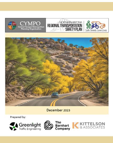
CENTRAL YAVAPAI

1. Introduction
What is the CYMPO ACT-UP?
The Central Yavapai Active Community Transportation–Unified Plan (ACT-UP) is a bold step toward creating a safer, healthier, and more connected future for the region . Led by the Central Yavapai Metropolitan Planning Organization (CYMPO) in collaboration with its member agencies, ACT-UP is designed to build a cohesive non-motorized transportation network that links communities and expands travel options for all . This forward-thinking plan focuses on enhancing walking and biking infrastructure to promote regional health, equity, and mobility. More than just a vision, ACT-UP provides local jurisdictions with a clear, actionable road map - outlining priority projects and programs to turn ideas into reality and shape a more accessible and active Central Yavapai region.
WHAT IS ACTIVE TRANSPORTATION?
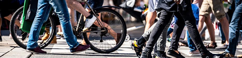
Active transportation includes walking, biking, skating, and other self-powered ways of getting around—including the use of assistive mobility devices. These modes offer people of all ages and abilities safe, affordable, and healthy travel options.
More than just “non-motorized,” active transportation connects communities while promoting physical activity, reducing transportation costs, and improving quality of life. By investing in walkable and bikeable infrastructure, regions can boost mobility, support economic opportunity, and create healthier, more sustainable places to live.
Why is Active Transportation Important?
Active transportation strengthens communities. It provides safe, affordable, and healthy ways to get around - while reducing traffic, lowering emissions, and supporting economic vitality. By investing in walkable and bikeable networks, communities can:
■ Expand mobility for people of all ages and abilities
■ Promote healthier lifestyles
■ Reduce transportation costs
■ Support local businesses and economic growth
Active transportation is more than a travel choice - it’s a smart investment for a connected, resilient, and vibrant future region.
CYMPO in Motion: Planning for a Better Connected Future
The Central Yavapai Metropolitan Planning Organization (CYMPO) is the federally designated MPO for the region, established in 2003 after the population surpassed 50,000. CYMPO coordinates transportation planning among local, state, and federal partners to ensure regional priorities guide funding and investment decisions. CYMPO’s member agencies include the City of Prescott, Towns of Prescott Valley, Chino Valley, and Dewey-Humboldt, Yavapai County, and ADOT. Additional planning partners include the YavapaiPrescott Indian Tribe, U.S. Forest Service, and the Arizona State Transportation Board.
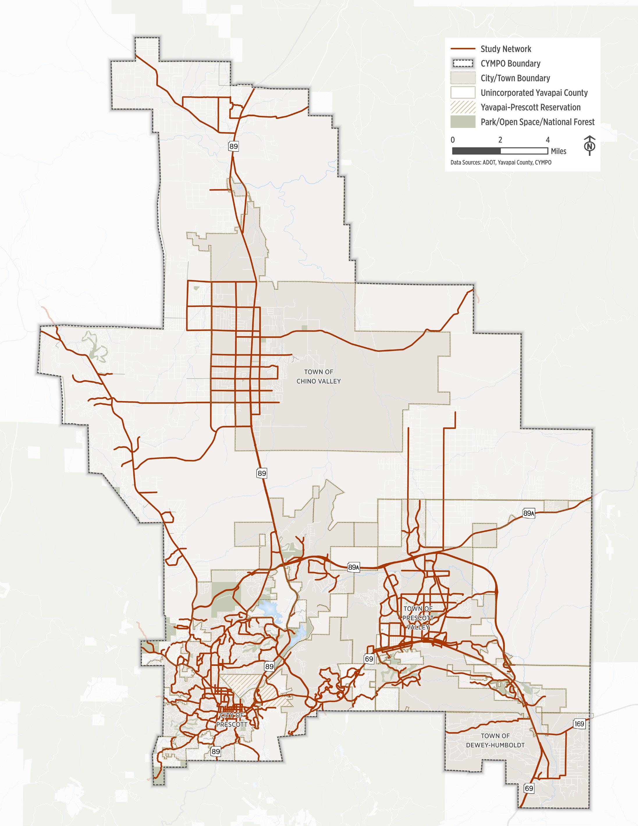
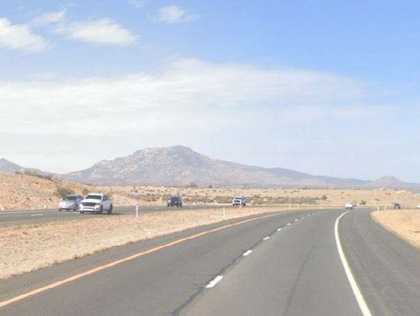
Study Network
The ACT-UP study area covers the entire CYMPO region, ensuring that urban, suburban, and rural communities are all part of the conversation. The active transportation network analyzed in this plan is based on two key components:
■ Regionally significant roadways as identified in the CYMPO 2045 Regional Transportation Plan (RTP), which serve as the backbone of the transportation system.
■ Key local connectors that close critical gaps, enhance neighborhood access, and link people to destinations like schools, parks, employment centers, and trailheads.
This strategic network framework ensures ACT-UP recommendations are grounded in real-world conditions and aligned with the region’s broader transportation goals. Figure 1 .1 illustrates the ACT-UP study network.

Figure
Who Are We Planning For?
The CYMPO ACT-UP is focused on creating a safer, more connected active transportation network that works for everyone—regardless of age, ability, or travel mode. Whether someone is walking to school, biking to work, or rolling to the park, ACT-UP aims to ensure that streets across the Central Yavapai region are comfortable, accessible, and inviting. This plan considers the needs of:
■ Children, families, and older adults
■ People using wheelchairs, mobility aids, scooters, or skates
■ Community members accessing daily needs by walking, biking, or rolling
■ Recreational users and road cycling enthusiasts
■ People with disabilities or limited mobility
■ Visitors exploring the region
■ Anyone who chooses- or relies on - nonmotorized travel
Each of these users experiences the transportation system differently and is sensitive to things like gaps in infrastructure, traffic speed and volume, pavement quality, shade, lighting, and perceived safety. ACT-UP is designed to address these factors and build a more connected and enjoyable active transportation network.
How Local Agencies Can Use ACT-UP
ACT-UP serves as a regional blueprint for expanding and improving walking, biking, and rolling infrastructure. It offers local agencies a data-driven, actionable framework to strengthen mobility, promote equity, and improve safety throughout the region. Local jurisdictions can use ACT-UP to:
■ Prioritize walking, biking, and rolling infrastructure projects
■ Pursue state and federal grant funding using data-backed recommendations
■ Align local plans with regional goals and standards
■ Support decision-making with tools and strategies included in the plan
■ Coordinate across jurisdictions for connected, cross-community networks
By using ACT-UP, communities in the Central Yavapai region can more effectively deliver safe, accessible, and inclusive transportation options that reflect the needs of all users.
The Planning Process
The development of the CYMPO ACT-UP was a collaborative, regionally focused effort that engaged residents, local jurisdictions, regional partners, and community stakeholders to shape a shared vision for active transportation in the Central Yavapai region. The planning process combined community input, data-driven analysis, and coordination with ongoing local and regional initiatives. This multi-phased approach included the following steps:
UNDERSTAND CURRENT CONDITIONS
We began by conducting a comprehensive inventory of existing conditions across the Central Yavapai region. This included assessing land use, population and employment trends, roadway characteristics, crash data, and existing pedestrian and bicycle infrastructure. This baseline helped us understand how the current system supports - or limits - active transportation.
IDENTIFIED SYSTEM ISSUES, NEEDS, GAPS AND OPPORTUNITIES
Through detailed analysis, we identified key gaps in the walking and biking network, assessed the comfort and safety of existing routes, and pinpointed underserved areas. We also analyzed non-motorized travel potential to highlight areas with the highest opportunity for impact.
IDENTIFIED AND EVALUATED POTENTIAL IMPROVEMENT SOLUTIONS
Building on identified needs, the team developed a range of project and program concepts. These were evaluated based on safety, connectivity, equity, feasibility, and community benefit. The most impactful solutions were prioritized for near- and long-term implementation.
DEVELOPED PHASED IMPROVEMENT PLAN
The final recommendations were organized into a phased improvement plan that balances quick wins with long-term goals. The plan provides local jurisdictions with a realistic, fundable road map to improve walking and biking options across the region.
Community and Stakeholder Engagement
Throughout the development of the ACT-UP, we actively engaged residents, visitors, and stakeholders across the CYMPO region. Through focus groups, community events (both in-person and virtual), online surveys, and social media outreach, we gathered valuable input on how to improve walking, biking, and rolling - today and into the future. We also worked closely with CYMPO’s standing committees and local agency partners to ensure the plan reflects real-world transportation needs, aligns with regional goals, and supports the priorities of the communities it serves.
Connecting Planning Efforts
The Central Yavapai region has built a solid foundation of transportation and land use planning, and the CYMPO ACT-UP builds on that momentum. In recent years, local jurisdictions and CYMPO have made significant strides in planning for walkable, bikeable communities. This plan brings those efforts together—reviewing and integrating recommendations from past and ongoing plans to create a unified, actionable road map for active transportation. By aligning regional priorities, ACT-UP helps ensure that limited resources are directed toward the most impactful projects.
Contributing and Supporting Plans*
*A full set of local and regional studies and plans that were reviewed are provided in the appendix.
Vision and Goals Driving ACT-UP
The establishment of a clear vision and goals is important because they set a foundation for plan development and ultimately inform decision-making and prioritizing transportation improvement investments. The ACT-UP vision and goals outlined below were founded and informed by feedback from CYMPO staff, member agency and community input, and alignment with previous plans. CYMPO ACT-UP is built on a clear vision: to create a safe, connected, and inclusive active transportation network that supports healthier lifestyles, accessible mobility, and vibrant communities.
Vision for Active Transportation
Central Yavapai’s transportation system includes a network of regionally coordinated and connected walking and bicycling facilities that provide safe and convenient access to services and recreational destinations for users of all ages and abilities in both rural and urban communities.
ACT-UP’s Guiding Principles
The guiding principles and strategies for ACT-UP will help achieve the desired outcomes established in the vision statement. Guiding principles are general statements that the ACT-UP aims to achieve over time. These goals align with – and do not replace – adopted policies and goals held by CYMPO member agencies.
Safety
Increase the safety of people walking and bicycling in Central Yavapai through welldesigned facilities.
Accessibility
Develop walking and bicycling networks that are designed to accommodate all users, regardless of age or ability,
Funding and Implementation
Establish a feasible network of walking and bicycling facilities that minimizes barriers to funding, implementation, operation, and maintenance.
Connectivity
Provide convenient and direct walking and bicycling connections to regional and local destinations such as schools, services, and recreation.
Regional Equity
Improve the quality of life for the region’s disadvantaged areas, and balance the needs of both rural and urban communities.
2. Existing Conditions and Network Analysis
Overview of the Region Today
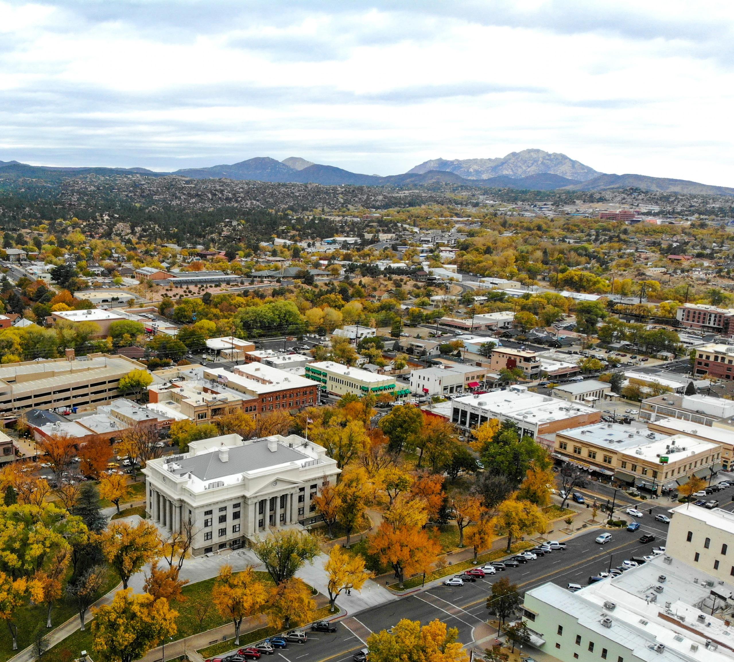
Once known primarily for its small-town charm and natural beauty, the Central Yavapai MPO region is evolving into a vibrant, growing community while still honoring its rich cultural and environmental heritage. Positioned in the heart of northern Arizona, the region’s quality of life, scenic landscapes, and economic opportunity have attracted a diverse and multi generational population.
How the CYMPO Region is Changing
According to the 2023 U.S. Census Bureau American Community Survey and other regional data sources, several key trends are shaping the future of transportation in the Central Yavapai region—especially the need for safe, equitable, and accessible active transportation options:
A Diverse Population: The region’s median age continues to rise, increasing the demand for age-friendly infrastructure like smoother sidewalks, safer crossings, and accessible trails. At the same time, a large portion of residents under 18 need safe routes to schools, parks, and youth-oriented destination.
Household Incomes Are Rising - but Inequities Remain: While median household income has grown over time, 11.6% of residents still live below the poverty line. Affordable transportation options are essential for supporting mobility and access to opportunity for lowerincome households.
Vehicle Access Remains Uneven: Though a high percentage of commuters drive alone, nearly 4% of households lack access to a vehicle. This makes connected sidewalks, bike networks, and access to transit critical for ensuring mobility and independenceespecially in underserved and rural areas.
Mobility is Not One-Size-Fits-All: The region’s changing demographics - an aging population, youth, and growing diversity - underscore the need for inclusive design. Active transportation infrastructure must meet a wide range of needs, abilities, and travel preferences.
Figure 2.1. Population and Employment Density and Key Activity Centers (ACS 2023)
Living and Working the Region
The Central Yavapai region is growing, increasing demand for safe, connected ways to walk, bike, and roll. As development becomes more urban, active transportation infrastructure is essential to support quality of life and evolving mobility needs. To support both quality of life and mobility choices, transportation planning must adapt to meet the changing needs of residents, workers, and visitors.
A Growing Region = Growing Active Transportation Demand
The CYMPO region is projected to grow significantly by 2050 - with population increasing by over 30% and employment by more than 26%. Fueled by in-migration and economic expansion, this growth is reshaping community needs and placing new demands on the transportation system. As more people live and work in Central Yavapai, the need for safe, connected options to walk, bike, and roll will continue to rise. This growth will:
■ Increase demand for neighborhood-scale mobility, such as sidewalks, trails, and bike facilities
■ Drive interest in safe, direct walking and biking routes to job sites and commercial areas
■ Strain existing infrastructure, revealing gaps in safety, comfort, and connectivity
■ Strengthen the case for low-cost, high-impact investments like pedestrian crossings and shared use paths
■ Underscore the need for first- and last-mile connections to transit
Where We Shop, Play, and Learn
Activity centers are vital to daily life in the CYMPO region - combining shopping, healthcare, education, recreation, and employment in key community hubs. These destinations draw people from across the region, making safe, convenient walking, biking, and transit access essential for supporting mobility, equity, and economic growth. Figure 2 .1 highlights major activity centers and transportation generators, including:
K-12 Schools and Higher Education
The CYMPO region includes numerous K–12 schools and several higher education institutions, such as Yavapai College, Embry-Riddle Aeronautical University, Prescott College, and Northern Arizona University. With many students living nearby, safe walking, biking, and transit access to schools and campuses is essential to reduce congestion, promote healthy travel, and support regional mobility.
Healthcare Facilities
The CYMPO region includes major healthcare providers such as Yavapai Regional Medical Center, the VA Health Care System, and several community clinics. These facilities are key destinations, underscoring the need for safe, connected active transportation access to support both public health and mobility.
Commercial Centers
Retail hubs near residential areas and major corridors are key daily destinations. To support access for all users - not just drivers - there is a growing need for safe sidewalks, bike facilities, crossings, and transit connections that link neighborhoods to these centers and reduce reliance on singleoccupancy vehicles.
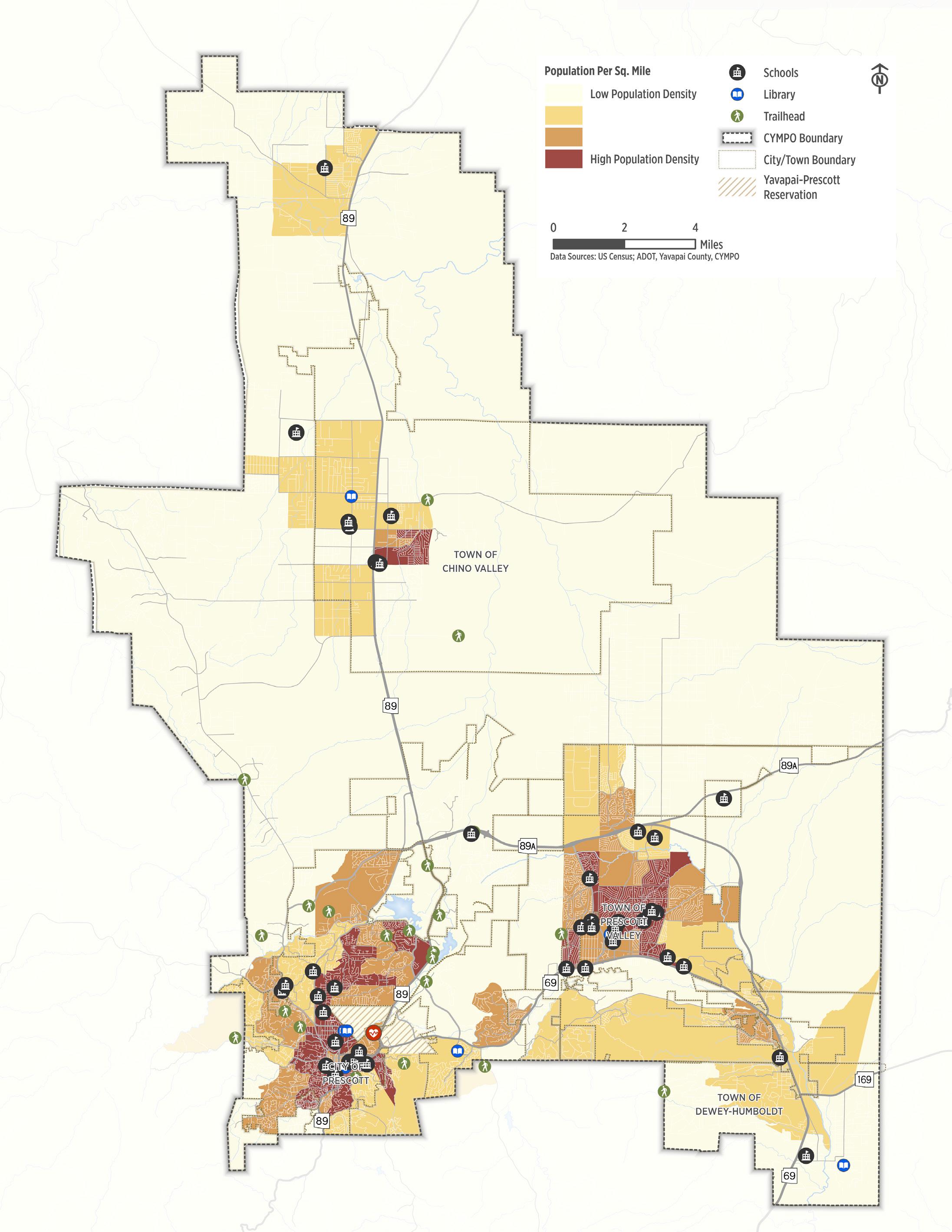
Figure 2.1. Population and Employment Density and Key Activity Centers
How We Travel in the Region
With a growing mix of travel options including walking, biking, e-bikes, transit, and ride hailing, residents and visitors in the Central Yavapai region have more ways than ever to reach their destinations. Understanding how, when, and where people travel is critical to planning a transportation system that meets current needs and adapts to future demand. To support this effort, the ACT-UP planning team used Replica, a data platform that integrates anonymized data from the U.S. Census, mobile devices, land use, and economic activity. The analysis offers a detailed view of weekday and weekend travel patterns, helping identify where active transportation infrastructure is most needed to build a safe, efficient, and accessible network.
Where We Want to Go and How We Get There
People travel for many reasons each day, whether going to the doctor or taking a stroll at Watson Lake for exercise. Travel choices often depend on the trip purpose, day of the week, and distance to the destination. Replica data shows that while most community members drive, walking is the second most common mode of travel across all trip types. As shown in Table 2 .1, driving accounts for the majority of trips; however, walking represents 20% of all shopping trips.
Converting Short Vehicle Trips to Active Modes
Replica can also help quantify the potential for converting short-distance trips from private vehicles to walking and biking. Figure 2 .2 shows the density of vehicle trips that are two miles or less. As shown in the figure, there is a concentration of short trips around the downtown areas of Prescott and Prescott Valley. With the presence of low stress walking and biking facilities, many of these trips could be converted to active modes.
Figure 2.1. Travel Pattens by Trip Purpose in the CYMPO Region (Replica)
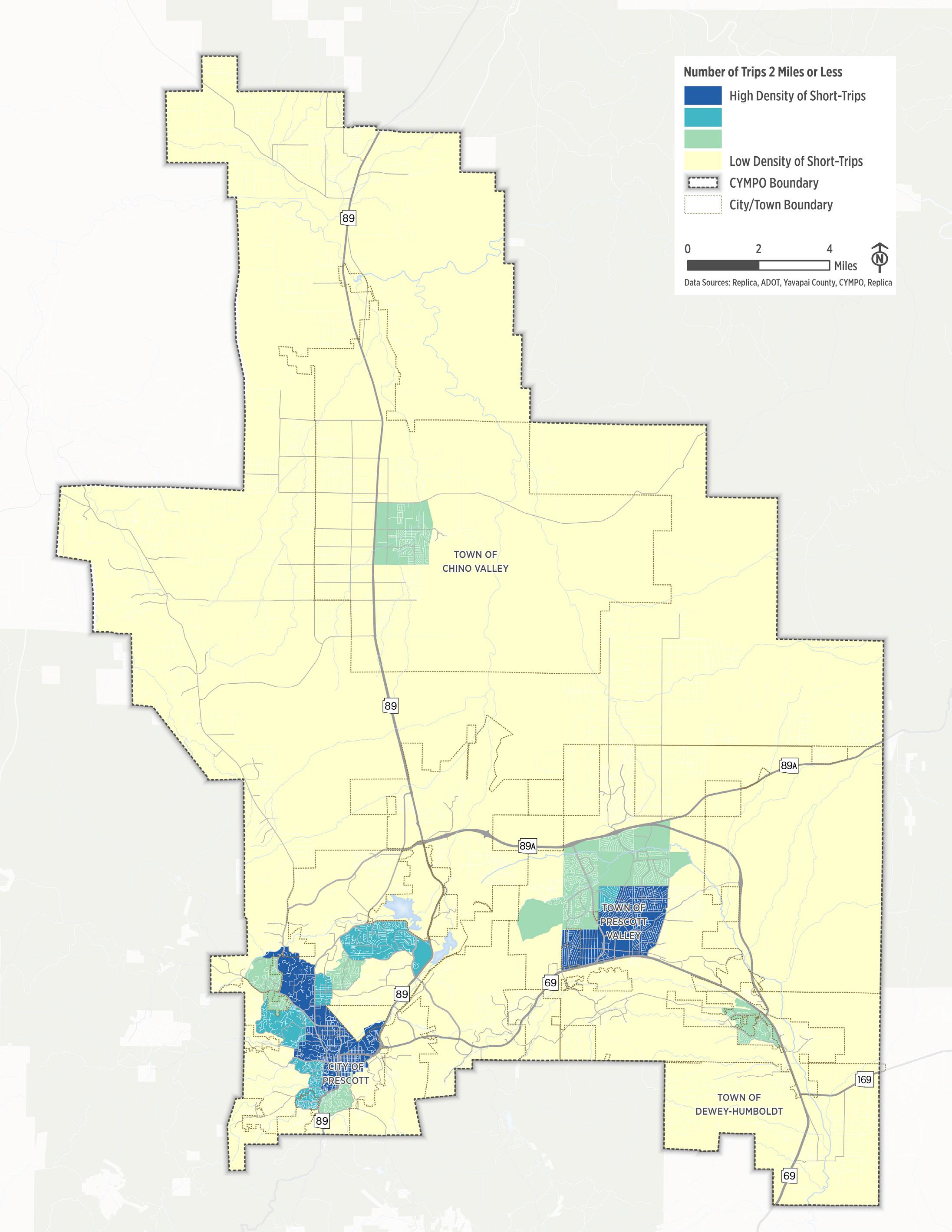
Figure 2.2. Replica Short-Trips Density Map
Our Transportation Network Today
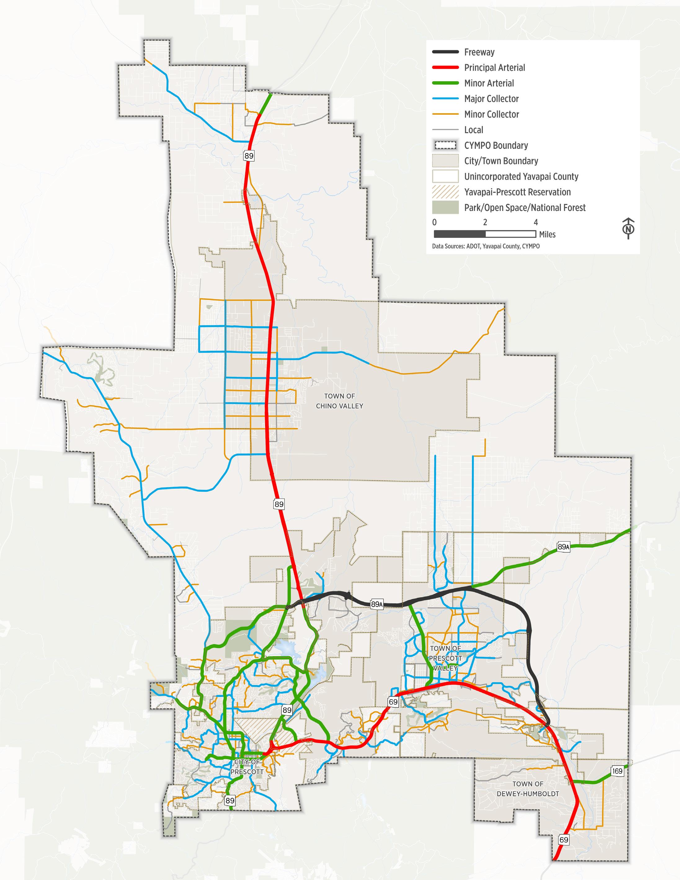
Travel corridors in the CYMPO region connect communities to jobs, services, and destinations. Roadways are classified by function—guiding their design, speed, and land use context. Understanding these classifications is essential for active transportation planning, as factors like traffic volume, lane width, speed, and road condition directly affect comfort and safety for people walking and biking. The region features a mix of roadway types, from rural highways to local streets, each playing a unique role in shaping travel patterns and user comfort.
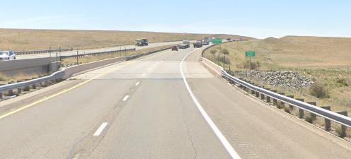
Major Highways
The CYMPO region is served by major highways including State Route 69 (SR 69), State Route 89 (SR 89), and State Route 89A (SR 89A). These corridors are vital for regional travel and freight movement but generally do not accommodate walking or biking. However, their interchanges and adjacent roadways often create barriers—or opportunities—for improved active transportation connectivity.
Arterials
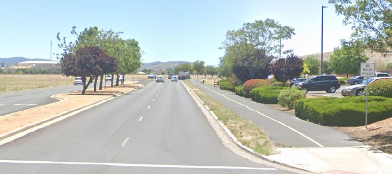
High-capacity roads with multiple lanes and higher speeds that connect residential, commercial, and industrial areas to highways. While essential for vehicle mobility, their high speeds and volumes often make them uncomfortable for walking and biking without separated facilities.
Collectors
Mid-sized roads that link local streets to arterials, typically with moderate speeds and traffic volumes. With the right infrastructure, collectors can provide safer, more comfortable active transportation connections through residential and commercial areas.
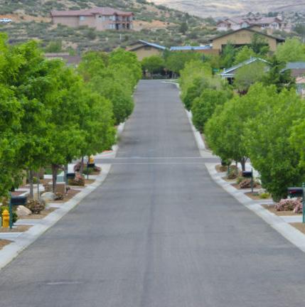
Local Streets
Low-speed (typically ≤25 MPH), low-volume roads found in neighborhoods. These streets often feature traffic calming and onstreet parking, making them ideal for walking and biking with minimal infrastructure improvements.
Number of Lanes, Volumes, Widths, and Right-of-Way
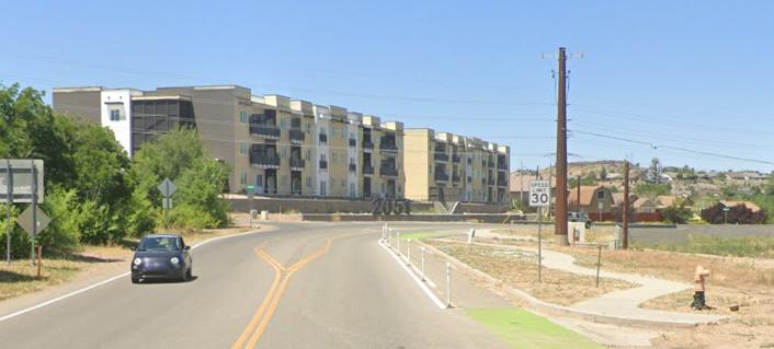
The number and width of travel lanes in the CYMPO region, along with available right-of-way, directly impact the feasibility and comfort of walking and biking. Local and collector streets typically range from two to four lanes, while major arterials may have six or more. Wide, multi-lane roads often create higher stress environments for people biking or walking - especially without separation from vehicle traffic. While travel lanes are often built to accommodate projected vehicle volumes, some roads may have more lanes than necessary, offering opportunities to repurpose space for bike lanes, sidewalks, or other multimodal uses.
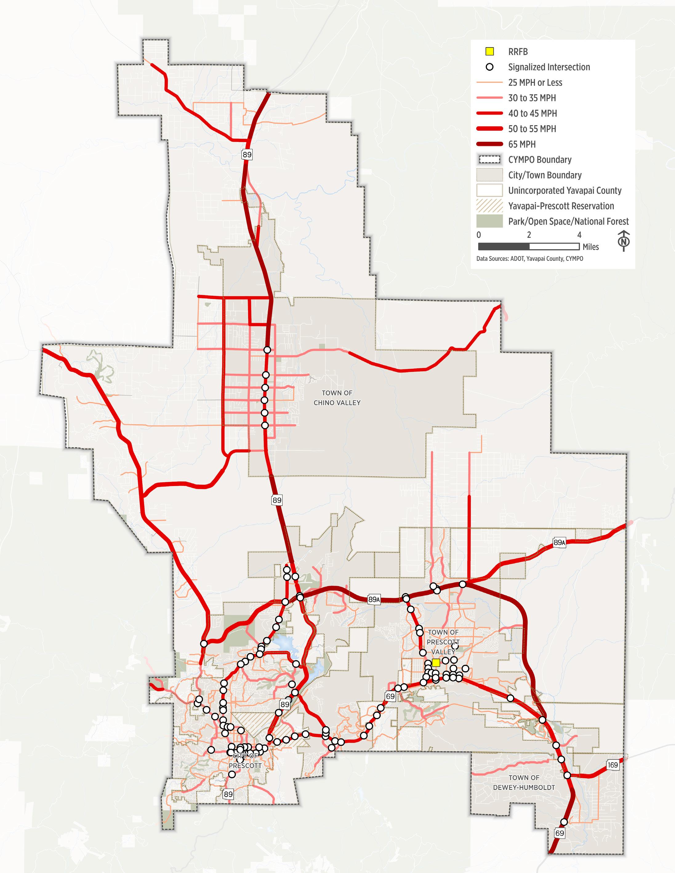
Posted Speed Limits
Vehicle speed plays a major role in pedestrian and bicyclist safety. Higher speeds reduce driver peripheral vision and reaction time, making it harder to detect people walking, biking, or crossing the street. Slower speeds increase visibility, reduce crash severity, and significantly improve comfort for all road users. Designing for lower speeds - especially on roads near schools, neighborhoods, and commercial areas - is a key strategy for creating a safer and more inclusive active transportation network.
Intersection Control
Traffic control devices help manage the movement of people and goods in an efficient manner. Traffic control devices found in the region today generally include:
■ Traffic Signals . Manage the flow of vehicles at intersections. Optimizing signal timing can improve mobility and reduce congestion.
■ Roundabouts & Traffic Circles . Circular intersections where traffic flows around a central island. They reduce conflict points, improve safety, and encourage lower speeds.
■ Stop Signs . Require drivers to come to a complete stop and proceed only when the way is clear, enhancing safety at lower-volume intersections.
■ Yield Signs . Instruct drivers to slow down and yield the right-of-way to cross traffic or pedestrians before proceeding.
Figure
Walking in the Region Today
Sidewalks are essential for both daily travel and recreation, particularly for people without vehicle access or with mobility challenges. Sidewalks are the backbone of any pedestrian network; their condition affects all pedestrians, particularly individuals with disabilities. Uneven surfaces, obstructions, or poor sidewalk conditions create deterrents or barriers in the pedestrian network.
Existing Facilities
In the CYMPO region, sidewalks, shared-use paths, and supporting features—such as crossings, curb ramps, and traffic calming—are essential for creating safe, accessible walking environments.
■ Sidewalks are paved pathways located alongside roads, dedicated to people walking, jogging, or using personal mobility devices (e.g., wheelchairs, walkers).
■ Shared Use paths are wider, off-street facilities designed to accommodate both pedestrians and bicyclists, as well as other permitted non-motorized users like scooters and skateboards.
While many urban streets include sidewalks, gaps remain—particularly in residential, suburban, and sporadically developed areas. These gaps limit connectivity and pose safety challenges, especially for people who rely on walking as a primary mode of travel. Figure 3 .7 illustrates the location of existing pedestrian facilities in the region
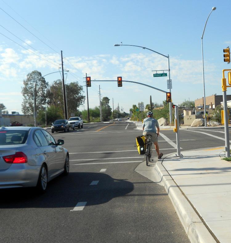
Crossing the Street
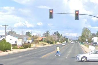
To complete the pedestrian network, sidewalks must be supported by features that enhance visibility, safety, and comfort. These include signage, marked crosswalks, curb ramps, refuge islands, overpasses, and signalized crossings. Street crossings are especially critical - particularly on wide, high-speed roads where poor design can discourage walking. While all intersections in Arizona are legally pedestrian crossings unless signed otherwise, enhancements like signals, flashing beacons, and median islands improve safety and encourage proper use.
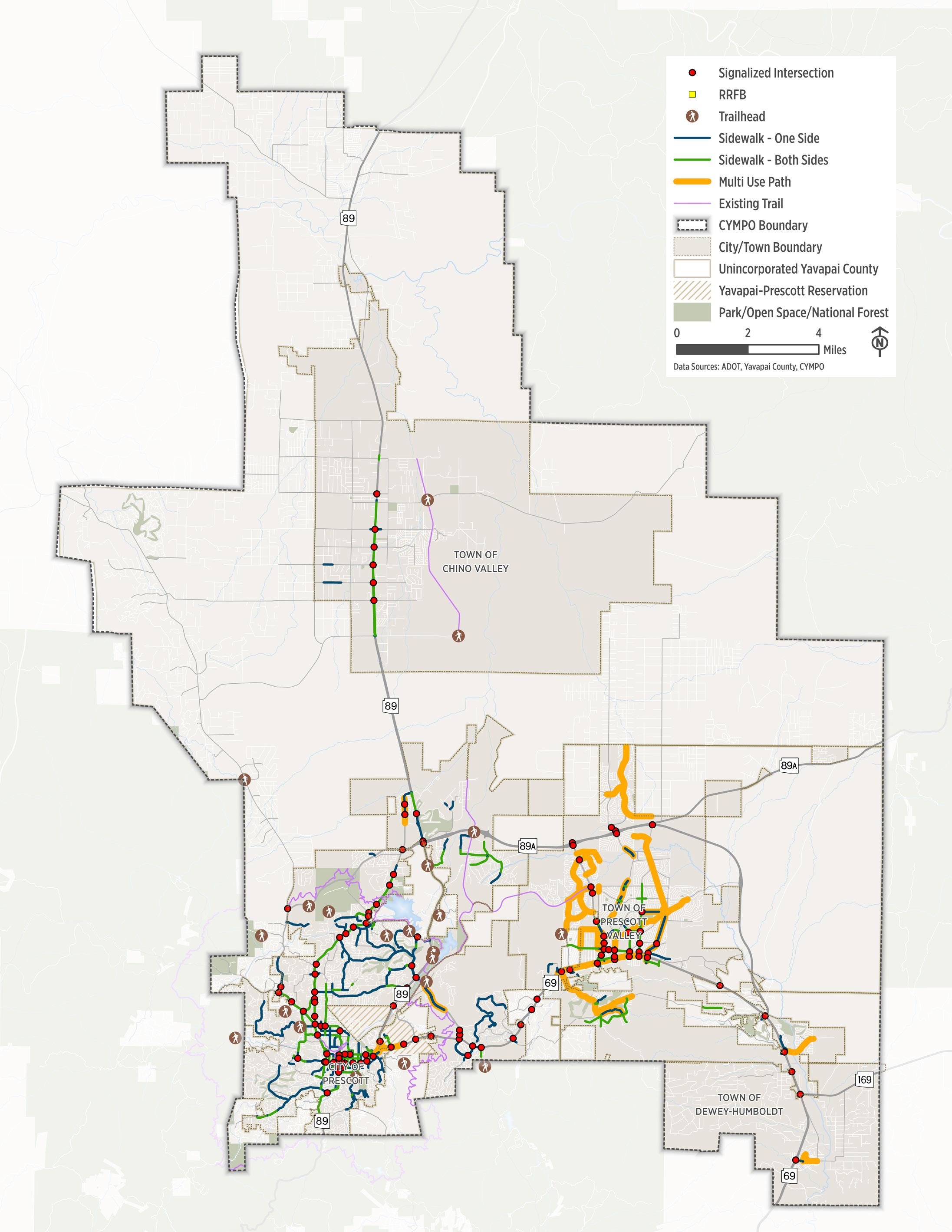
Figure 2.5. Existing Pedestrian Facilities
Biking in the Region Today
A complete, connected bicycle network that is comfortable and safe for people of all ages and abilities is critical to making biking a viable transportation option for travel in the CYMPO region. Expanding and enhancing the bicycle network can help reduce congestion and stress on the local streets and regional roads, as people can choose to bike rather than drive.
Existing Facilities
The CYMPO region includes a variety of bicycle facilities that support both recreational and transportation use. Currently, the network consists of:
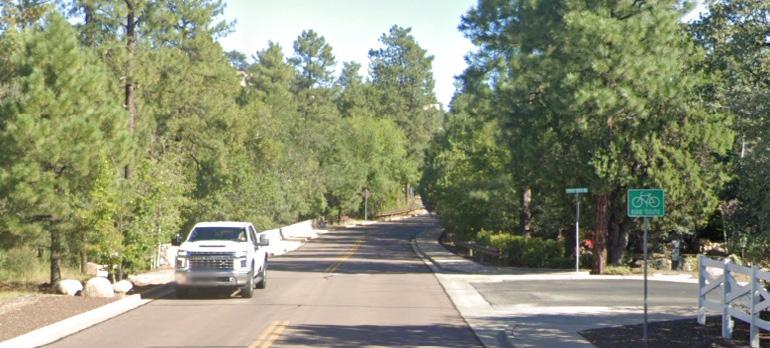
Bike Lane . A striped lane that is 4 feet wide or more, designated for bicycle use. It may include pavement markings and a buffer zone separating it from motor vehicle traffic. Bike lanes can be adjacent to curb and gutter or located along a flush shoulder, depending on the roadway design.
Paved Shoulder . A paved area 4 feet or wider located at the edge of the roadway. While not always designated for bicycles, it can be used by cyclists and may be widened or enhanced to provide greater separation from vehicle traffic and improve safety.
Signed Bike Route . A low-speed, low-volume roadway where bicyclists and vehicles share the same travel lane, identified by bike route signage. These routes typically require no dedicated bike lane but aim to guide cyclists along safer, more comfortable streets.
Separated
Bike Lane . A street-level, or raised, bike facility that includes a physical barrier—such as curbs, bollards, planters, or parked cars—providing protection from motor vehicle traffic and increasing comfort and safety for bicyclists.
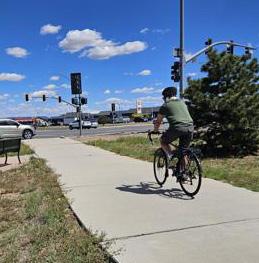
Shared Use Path . An off-street facility that physically separates pedestrians and bicyclists from motor vehicles. It offers a comfortable, low-stress experience with minimal vehicle interactions, often used for both recreation and transportation
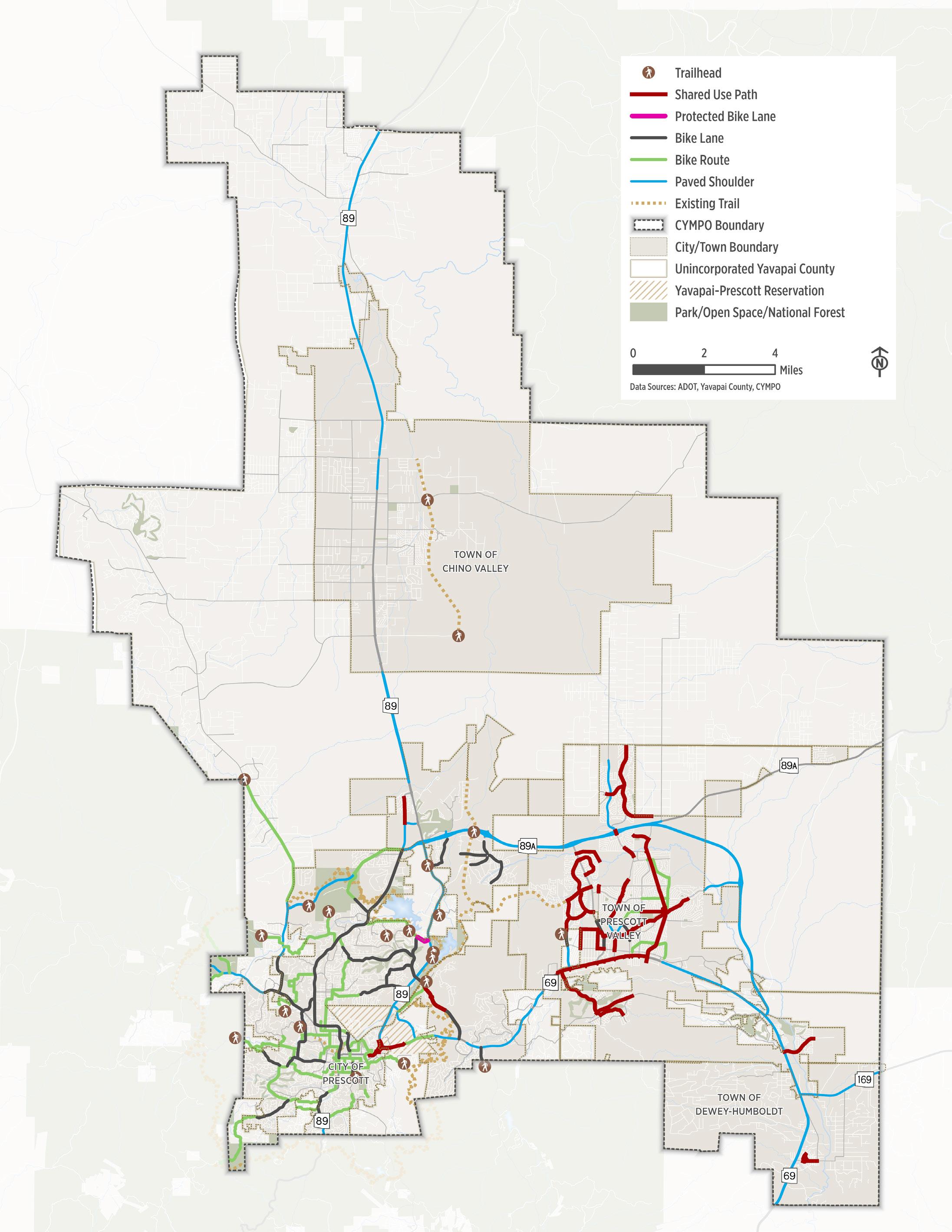
Figure 2.6. Existing Bicycle Facilities
How Comfortable Are Our Streets?
In the CYMPO region, improving the comfort and safety of the bike network is critical to making cycling a viable option for people of all ages and abilities. While confident riders may feel comfortable on most roads, many others—especially children, older adults, and new cyclists—need low-stress environments to feel safe. To better understand current conditions and identify areas for improvement, CYMPO conducted a bicycling comfort analysis using national guidance from FHWA’s Multimodal Network Connectivity Guide, the Bikeway Selection Guide, and NACTO’s All Ages and Abilities framework.
Calculating Bicycle Level of Traffic Stress (LTS)
As part of this analysis, CYMPO applied the Level of Traffic Stress (LTS) methodology, which measures how comfortable a roadway feels to bicyclists based on factors like traffic speed and volume, roadway design, and the presence and type of bike facility. Each roadway segment was assigned an LTS score from 1 (low stress) to 4 (high stress):
■ LTS 1: Comfortable for nearly all riders, including children and casual cyclists
■ LTS 2–3: Suitable for more confident riders but may discourage others
■ LTS 4: Only comfortable for experienced cyclists tolerant of high-speed, high-volume conditions
Gaps in the network and corridors with high LTS ratings often discourage biking, force lengthy detours, or push people toward driving instead. This analysis helps prioritize improvements to create a connected, low-stress network that encourages more people to choose biking for everyday travel.
Figure 2.1. Population and Employment Density and Key Activity Centers
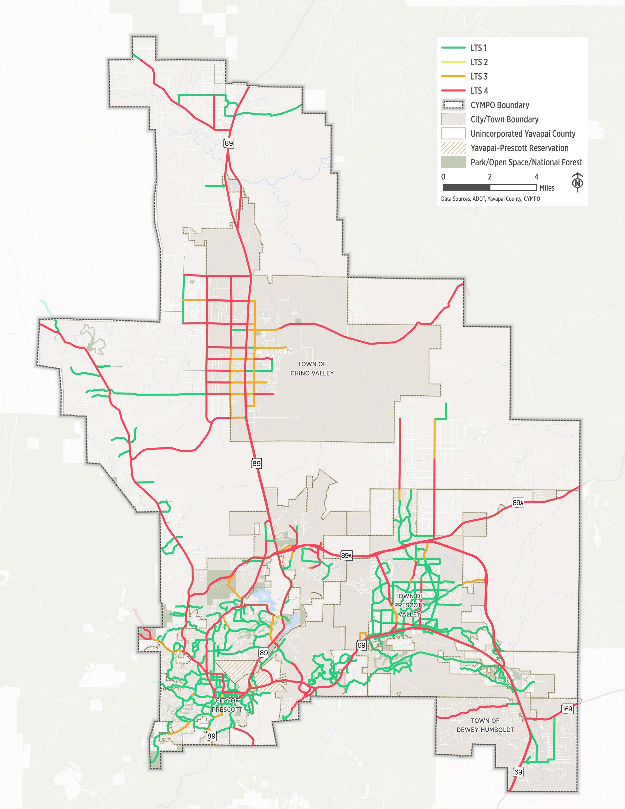
Figure 2.7. Bicycle Level of Traffic Stress (LTS)
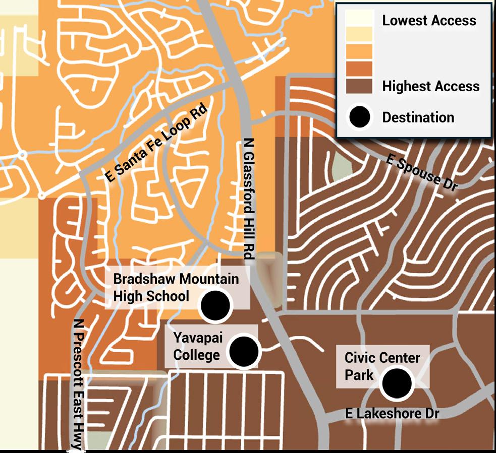
Bikeability Assessment: How Far Can You Go by Bike?
Access to destinations by bike is different than by car - distance, comfort, and safety play a much greater role. While drivers can travel long distances quickly, people on bikes are more affected by traffic stress, infrastructure gaps, and physical barriers. In the CYMPO region, understanding how far someone can comfortably travel by bike helps identify where to improve low-stress connectivity.
To assess this, CYMPO conducted a two-mile bike accessibility analysis using the existing low-stress network. The process included:
■ Identifying key destinations (e.g., schools, parks, grocery stores, medical centers)
■ Mapping two-mile bike sheds using only roads and paths rated LTS 1 or 2
■ Using U.S. Census block group data to estimate the population within each bike shed
Figure 2 .2 illustrates how well different areas of the CYMPO region can access key destinations within a two-mile bike ride on the low-stress network (LTS 1–2). Areas were categorized by access level from lowest (no destinations reachable within two miles) to highest (access to all destination types).
Key Findings
■ Chino Valley: Overall low accessibility due to limited low-stress infrastructure and dispersed land uses. Better access is seen along SR-89 between Perkinsville Road and Center Street.
■ Dewey-Humboldt: Also shows generally low access, though some destinations near Town Hall, Humboldt Elementary, and the library east of SR-69 are reachable via low-stress routes.
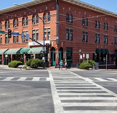
■ Prescott: High accessibility in and around Downtown Prescott, where dense development and a strong lowstress street grid overlap. Access declines in northern and eastern areas where high-stress roads and lower density act as barriers.
■ Prescott Valley: Strong access in the town core, especially along SR-69 and south of Lakeshore Drive. Accessibility decreases farther north and east, with an exception in southeastern Prescott Valley.
■ Unincorporated Yavapai County: Very low accessibility due to sparse development and limited bike infrastructure. An exception is the Prescott Country Club, which shows some access.
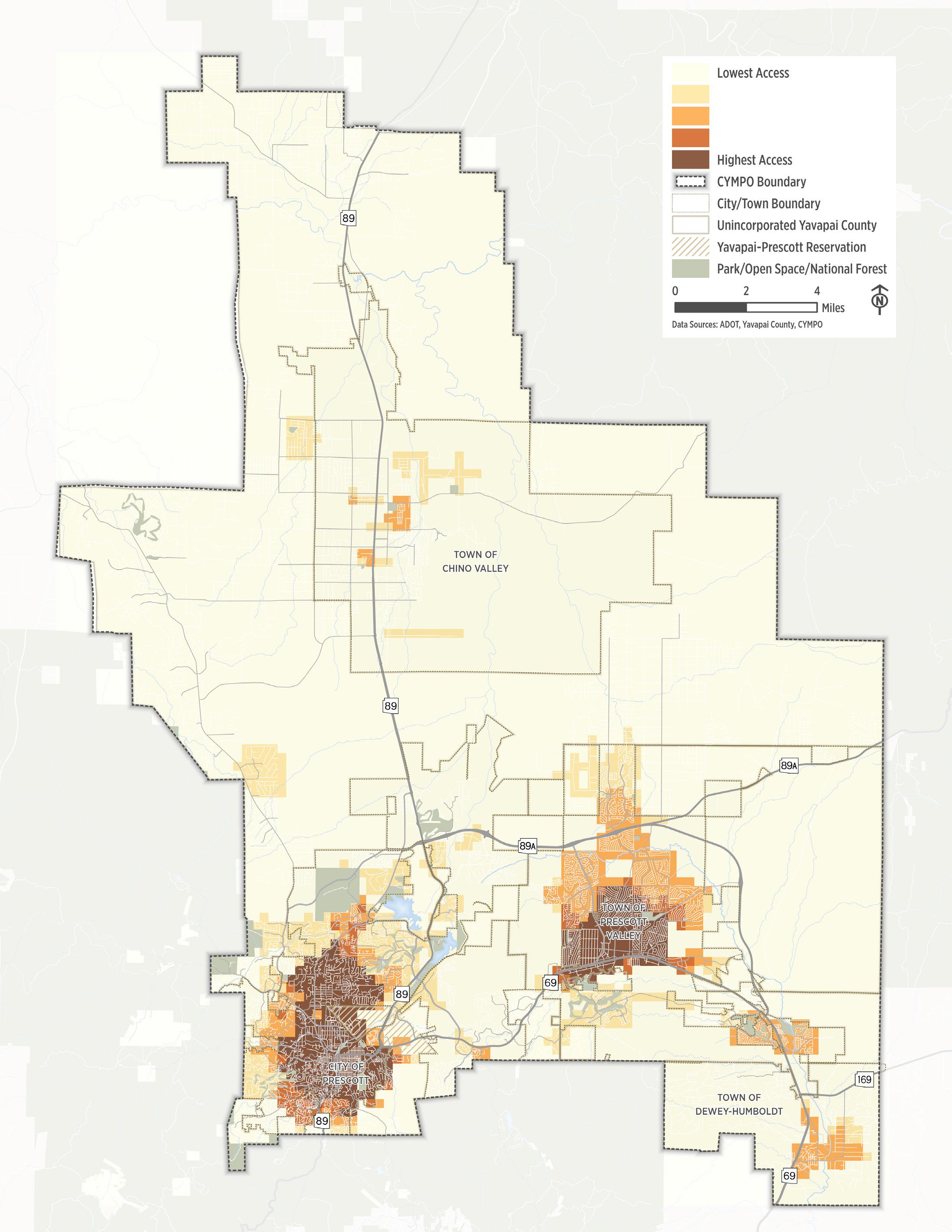
Figure 2.8. Bike Access Via a 15-Minute Bike Ride
How Safe Are Our Streets?
Safety (and the perception of safety) plays a key role in people’s decision on whether walking or bicycling is a viable way to make their trip. Analyzing the location and characteristics of crashes that involve people walking or bicycling provides us with important information for decisions on safety improvements, whether helping prioritize locations that require improvements, or highlighting the roadway characteristics or user actions that can help shape countermeasures.
To conduct this analysis, CYMPO reviewed a database of reported crashes compiled for the Northern Arizona Council of Governments (NACOG) Northern Arizona Regional Transportation Safety Plan (RTSP). Crashes involving people walking and/or bicycling are shown in Figure 2 .9
Key Findings
Bicycle and pedestrian crashes, trends, and other attributes such as contributing factors were reviewed within the CYMPO region, its cities/towns, and unincorporated areas. Crashes primarily took place within the City of Prescott and the Town of Prescott Valley, with none taking place within the Town of Dewey-Humboldt.
52 5 pedestrian& bicycleinvolved crashes over years in the CYMPO region
While the number of bicycle crashes has generally declined, pedestrian crashes have remained generally constant save for an increase in 2019.
75 250ft % Approximately of pedestrian & bicyclist crashes occur at or within of an intersection
Pedestrian
head-on
40 1 pedestrians & bicyclists fatality or serious injury of crashes involving resulted in at least Almost % broadside
& Bicycle Crash Types
The reported crash type provides an indication of the movements most frequently involved in crashes and in severe outcomes.
25 % of pedestrian crashes occurred in dark conditions pedestrian crashes
The majority of occurred while an individual was crossing the road
Figure 2.9. Crash Density and Location of Fatal and Severe Injury Pedestrian and Bicycle Crashes
3. What We Heard From the Community
How We Engaged the Community
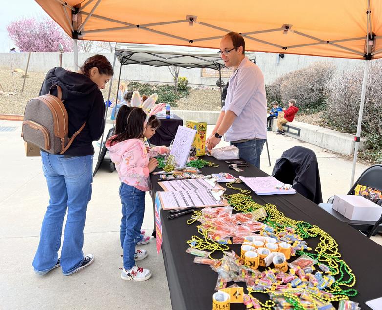
Throughout the development of CYMPO’s ACT-UP, input was gathered from community members, local agencies, advocacy groups, and community partners to ensure the plan reflects the lived experiences, priorities, and needs of people who walk, bike, and roll across the region. This chapter highlights the voices and ideas that shaped the plan.
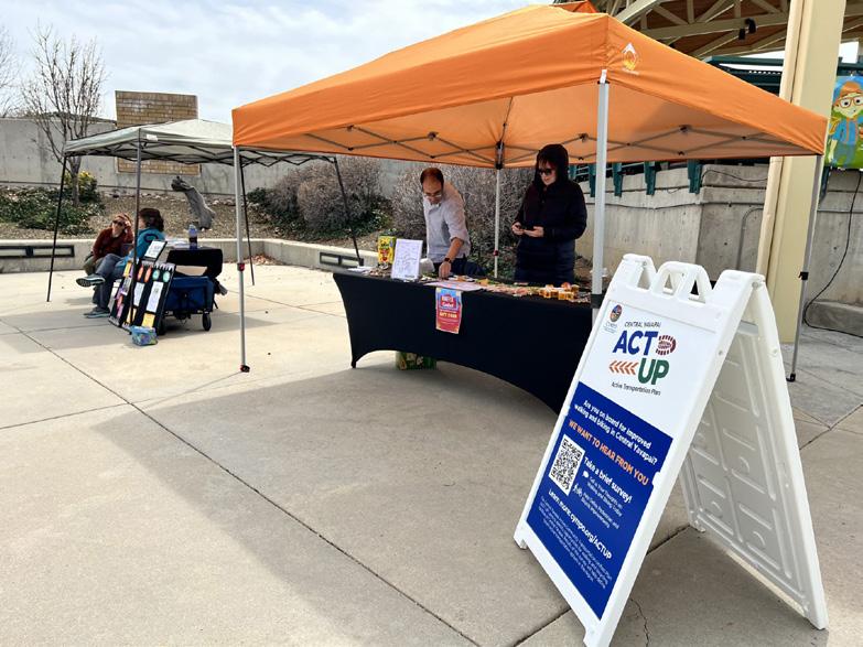
Project Website
The website www.cympo.org/actup served as the central hub for the CYMPO ACT-UP. It provided project updates, educational materials, and opportunities for public input— including an interactive map to identify barriers, a public survey, and a comment form to submit feedback directly to the planning team.
Public Survey
To better understand community perspectives on active transportation, an online survey was conducted during winter and spring 2024. The survey included nine questions on travel behavior, current conditions, and desired improvements. Participants could also submit location-specific comments using an interactive map. A summary of results is provided in the Appendix.
Spreading the Word

To raise awareness about the CYMPO ACT-UP plan and encourage participation in the survey and interactive mapping tool, the study team promoted the effort through multiple channels:
■ Social media: Posts on CYMPO’s Facebook and Instagram page, shared by member agencies to broaden outreach.
■ Interactive workshops: Held with stakeholders and regional partners to discuss key issues and draft recommendations.
■ Email outreach: Sent to federal, state, local, and private stakeholders, encouraging them to share project information and participate.
Active Community Advisory Committee (ACAC)
A working group of local stakeholders played a key role in guiding the development of the ACT-UP plan. Meetings focused on existing conditions, safety concerns, priority locations, and potential improvements to support walking and biking in the region. The group also provided input on draft recommendations and reviewed the plan prior to finalization, ensuring it reflects local context and community needs.
What We Heard
Through traditional and social media, surveys, meetings, and workshops around the region, we heard from thousands of community members. The following outlines key themes we heard.
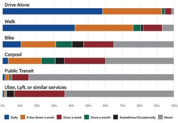
In an average week, how many days do you use the following modes of transportation?
76%walk
31%bike
Why do you walk or bike?
%
fun, recreation, or exercise
What prevents you from walking and biking more?
LACK OF DEDICATED BIKE SPACES DO NOT FEEL SAFE
LACK OF SIDEWALKS IN THE REGION
%
Social trips Shopping & errands
Is walking and biking safe, convenient, and practical in rural and urban areas?
Most respondents do not believe that walking and biking in either urban and rural environments is a safe, convenient, and practical way to get around.
How comfortable are you riding a bike?
are uncomfortable riding a bike on roads/in traffic
What types of improvements would you like to see in the region?
of respondents favored off-street parking and biking paths.
favored fill-in gaps in existing sidewalks favored new on-street bike lanes favored new sidewalks favored additional trails
are comfortable in most traffic conditions
are somewhat comfortable don’t like to ride a bicycle
What would you like to walk or bike to?
of survey respondents indicate that biking and walking access to parks and trails is a key need
Downtown Prescott is also a popular destination that more than half of respondents (64%) noted they would like to walk or bike to.
Are there any streets that you would like to see improved with walking, biking, or other facilities?
"I would love to walk with my kids to school, but we don't think it's safe."
“There
are no easy/ convenient ways to bike between two cities . ”
"Biking on roads with cars is unsafe. Too many distracted drivers."
"In the urban areas, the lanes for biking do not feel wide enough to get the appropriate three feet from cars. In the rural areas, the roads can be dicey when vehicles travel at high speeds."
“Many
traffic lights are not
geared to
allowing pedestrians
to cross.”
"I would also like to see more traffic control of the vehicles that are going faster than the posted speed limit. Also more signs/education regarding traffic laws."
“If I could walk I would, but there are no sidewalks and it is not safe to do so.
"There
are rarely sidewalks or bike lanes making it quite unsafe. If there were more options, I'd be much more likely to do either."
"Off street biking along the major thoroughfares (i.e. 69, 89, 89a) would really improve my desire to bike more/drive less, as distance is a large factor."
“Highway 89 between Chino Valley and the Prescott area should have widened lanes for bikes . ”
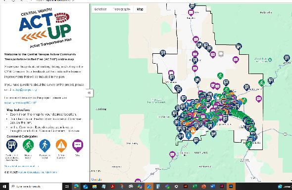

Mapping Activity
As part of the engagement process, participants were invited to share location-based input through an interactive feedback map. Users could identify:
■ Routes needing pedestrian or bicycle improvements
■ Specific spots requiring upgrades or repairs
■ Trail connection gaps
■ Pavement or sidewalk maintenance needs
■ Locations with safety concerns
■ Places where they would like to walk or bike
Participants could also comment on, agree with, or disagree with input submitted by others, allowing for a more interactive and community-driven feedback process.
4. Active Transportation Network Development
Network Development Process
This chapter presents CYMPO’s strategy for identifying, evaluating, and prioritizing active transportation improvements in the ACT-UP plan. The process began with a comprehensive needs assessment to highlight gaps and opportunities for walking, biking, and rolling, initially without factoring in physical constraints. This helped define the full extent of regional active transportation needs.
From there, a project list was developed and evaluated against clear goals and objectives using a scoring framework focused on safety, connectivity, equity, and feasibility. Top scoring projects were advanced into a prioritized implementation plan. The key steps in the network development process are outlined below:
Assess Existing Conditions & Community Needs
We began by establishing a strong foundation of data and local insight, that included
Inventory Existing Infrastructure
Analyze Network Performance
Accessibility Assessment Community + Stakeholder Input
STEP 1 STEP 3 STEP 4
STEP 2
Collect a Universe of Ideas
The study team gathered project ideas, including recommendations from on-going and previous plans, feedback from the public and local agencies, and results of the data analysis to create a universe of potential projects to address gaps and barriers in the region’s active transportation network.
Create a Vision for the Region’s Future Active Transportation Network
Using the collected input and analysis, the team developed a vision for a safe, connected, and accessible active transportation network that supports long-term mobility, health, and sustainability goals. The future network builds off Step 2 and includes:
Route Planning: Identifying priority corridors based on safety, demand, connectivity, and feasibility.
Design Typologies: Recommending contextsensitive treatments such as protected bike lanes, shared-use paths, and enhanced pedestrian crossings.
Scenario Testing: Evaluating alignment options, design trade-offs, and potential constraints to refine project concepts.
Evaluate Projects and Determine Priority/Phasing
To turn the vision into action, the team evaluated and prioritized projects for
Phased Recommendations: Organize projects into short-, medium-, and long-term investments based on impact, readiness, and funding potential.
Cost Estimates & Responsibilities: Developed planning-level cost estimates and identified the lead agency responsible for short-term recommendations.
Funding Alignment: Highlighted grant-ready projects and opportunities to leverage local, regional, and federal funding sources.
Identification of Needs
Identifying gaps and opportunities is the first step in developing a future-ready active transportation network for the CYMPO region. A comprehensive list of locations in need of pedestrian and bicycle improvements was developed through data analysis, stakeholder input, and community feedback.
The identification process considered:
Pedestrian Improvements
Projects that enhance neighborhood walkability, fill sidewalk gaps, and improve access to key destinations like schools, parks, and transit stops.
Bicycle Facility Upgrades and Expansion Projects
Investments that improve existing bike infrastructure and extend the bicycle network to support both local and regional non-motorized travel options.
Low-Stress Bicycle Connections
Projects that create safe, comfortable, and direct routes for cyclists of all ages and abilities by minimizing interactions with high-speed or high-volume traffic.
Intersection and Crossing Enhancements
Safety and accessibility improvements at key crossings and intersections to support safe pedestrian and bicycle movement, reduce conflicts, and improve visibility.
Gaps in the network often result from inconsistent development, physical constraints, or right-of-way limitations. Addressing these gaps can significantly improve mobility and connect people to jobs, schools, and essential services by foot or bike.
Prioritization of Improvement Needs
Once a complete set of infrastructure improvement needs were identified, a prioritization tool was developed to quantify the magnitude of each project’s contribution to the overall vision and goals of ACT-UP. The prioritization tool is a flexible approach, intended to provide clear direction for proactively seeking project funds and completing design and engineering of the most critical projects, while still allowing for opportunistic implementation of the entire network.
Project Prioritization Framework
Five key prioritization categories were identified and weights were assigned based on their overall contribution to the goals of ACT-UP. Key prioritization criteria included:
category focuses on increasing the safety of people walking and bicycling in through well-designed facilities, and developing walking and bicycling networks that are designed to accommodate all users, regardless of age or ability.
category focuses on establishing a feasible network of walking and bicycling facilities that minimizes barriers to funding, implementation, operation, and maintenance.
is consistent with a previously-identified project from another plan or has been identified by
Based on their scores, projects were grouped into three priority tiers to guide phased implementation and funding strategies:
projects with strong potential for impact and readiness
Tier
priority projects that address key needs but may require further coordination or planning Lower-priority or longer-term projects that support the broader network vision
These tiers help guide short-, mid-, and long-term investment decisions while advancing a safe, connected, and inclusive active transportation network across the CYMPO region. The results of the prioritization process are not intended to preclude projects from receiving funding or from being incorporated into a new development or other roadway project. All recommended improvement projects have merit and should be implemented as timely and costeffective opportunities arise.
Future Pedestrian Network
The pedestrian network is a critical component of the CYMPO region’s transportation system, as nearly every trip, whether by car, bus, or bike, begins or ends with walking. Improving pedestrian connectivity and safety makes it easier for people to complete trips on foot, helping to reduce congestion, support public health, and enhance community livability. However, sidewalk gaps remain throughout the region, limiting the ability to create a complete and accessible pedestrian network.
The recommended future pedestrian network includes recommendations in areas with the highest need and greatest potential for walking, as well as a long-term vision for expanding and enhancing walking connections. Together, this network aims to close critical sidewalk gaps, enhance safety at intersections, and create a more accessible and connected network for people of all ages and abilities. When integrated with the region’s existing infrastructure, the recommended projects form the foundation for a more walkable future across the CYMPO planning area.
Sidewalk Infill Improvements
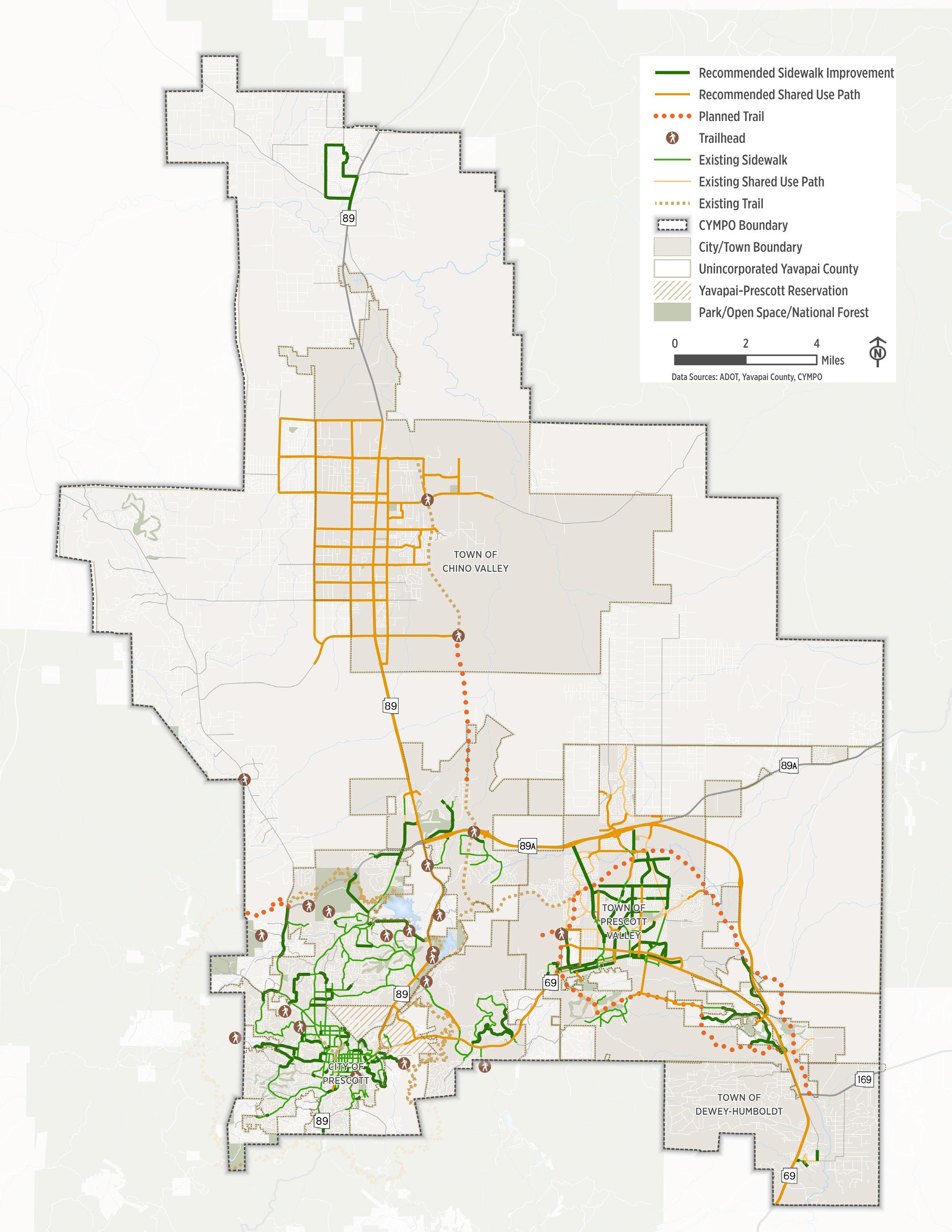
A pedestrian network is only as strong as its weakest link. In the CYMPO region, sporadic development patterns have led to gaps in the sidewalk network that create barriers to safe and continuous pedestrian travel. These gaps can significantly limit walkability and access. Filling these gaps offers a high-impact, cost-effective way to connect people to jobs, schools, transit, and daily destinations. Figure 4 .1 . shows the location of recommended sidewalk infill improvements.
Shared Use Path Network
The recommended shared use path network enhances multimodal connections to local and regional destinations across the CYMPO region. Addressing key crossing and infrastructure gaps first can provide immediate benefits, as many of these paths are already in use. Improved comfort and connectivity may also attract new users, including pedestrians, cyclists, runners, and equestrians. Figure 4 .1 . shows the location and priority of recommended improvements.
Building Walkability
The pedestrian priority streets reflect areas where the surrounding land uses offer opportunities to enhance the pedestrian environment to create more walkable and vibrant public spaces. Enhancements to the pedestrian experience may include:
■ Wider and/or Detached Sidewalks: allow more people to walk and provides room for placemaking.
■ Safe Crossings: conduct location specific engineering analysis to determine appropriate pedestrian crossing facilities.
■ Lighting: adding pedestrian-scaled lighting to improve visibility and safety.
■ Green Infrastructure: trees and landscaping provide shade, can lower temperatures, and create a buffer from vehicle traffic.
■ Amenities: cafe seating, benches, public art, trash/recycling receptacles and bicycle parking.
Figure
Future Bicycle Network
The bicycle network is a vital part of the CYMPO region’s transportation system, offering a flexible, low-cost, and sustainable travel option for a wide range of trips. Enhancing bicycle connectivity and safety across the region allows more people to use biking as a reliable mode of transportation, helping to reduce congestion, improve public health, and advance CYMPO’s regional mobility goals. However, network gaps and inconsistent infrastructure create barriers to safe and continuous travel by bike throughout the CYMPO region.
The recommended future bicycle network was developed around five key objectives:
■ Establish consistent facility types to support varying user comfort levels
■ Connect existing facilities to improve local and regional non-motorized mobility
■ Identify low-cost improvements within the existing roadway footprint
■ Upgrade routes to accommodate users of all ages and abilities
■ Address long-term regional connectivity needs
Implementing these recommendations will establish a robust regional bicycle network that offers a more comfortable experience for confident riders and low-stress options for children and less experienced bicyclists.
Bicycle Gap Improvements and Extensions
The CYMPO ACT-UP identifies key gaps in the existing bicycle network that limit access to destinations and comfort for riders of all experience levels. Recommended improvements focus on closing these gaps and expanding the regional network, including recreation-oriented routes. Figure 4 .2 shows the location of recommended new bicycle facilities.
Low-Stress Bicycle Connections
The CYMPO region has the opportunity to expand bicycle connectivity through low-cost improvements on low-speed, low-volume streets. Treatments like bike boulevards and bike routes - featuring signage, markings, and traffic calming - create safer, lowstress connections that improve comfort for all riders. These enhancements offer a cost-effective way to strengthen the regional network. Figure 4 .3 shows the location of these low stress connections.
Safety and Comfort
Continued investment in the CYMPO region’s bicycle infrastructure should focus on improving comfort and safety while applying best practices. As traffic speeds and volumes increase, greater separation between bicyclists and vehicles is key to a safer riding experience. In addition to standalone projects, bicycle facilities should be improved during roadway or sidewalk repaving and reconstruction. Well-designed intersections also enhance predictability and visibility for bicyclists and benefit all road users.
Design Trade-Offs
Creating a safe, comfortable, and convenient bicycle network may require tradeoffs with vehicle mobility and on-street parking. These can include narrowing lanes, reducing vehicle speeds, limiting turns at intersections or driveways, increased signal stops for drivers, and fewer on-street parking spaces. In some cases, reducing the number of travel lanes may also be considered if overall vehicle mobility remains adequate.
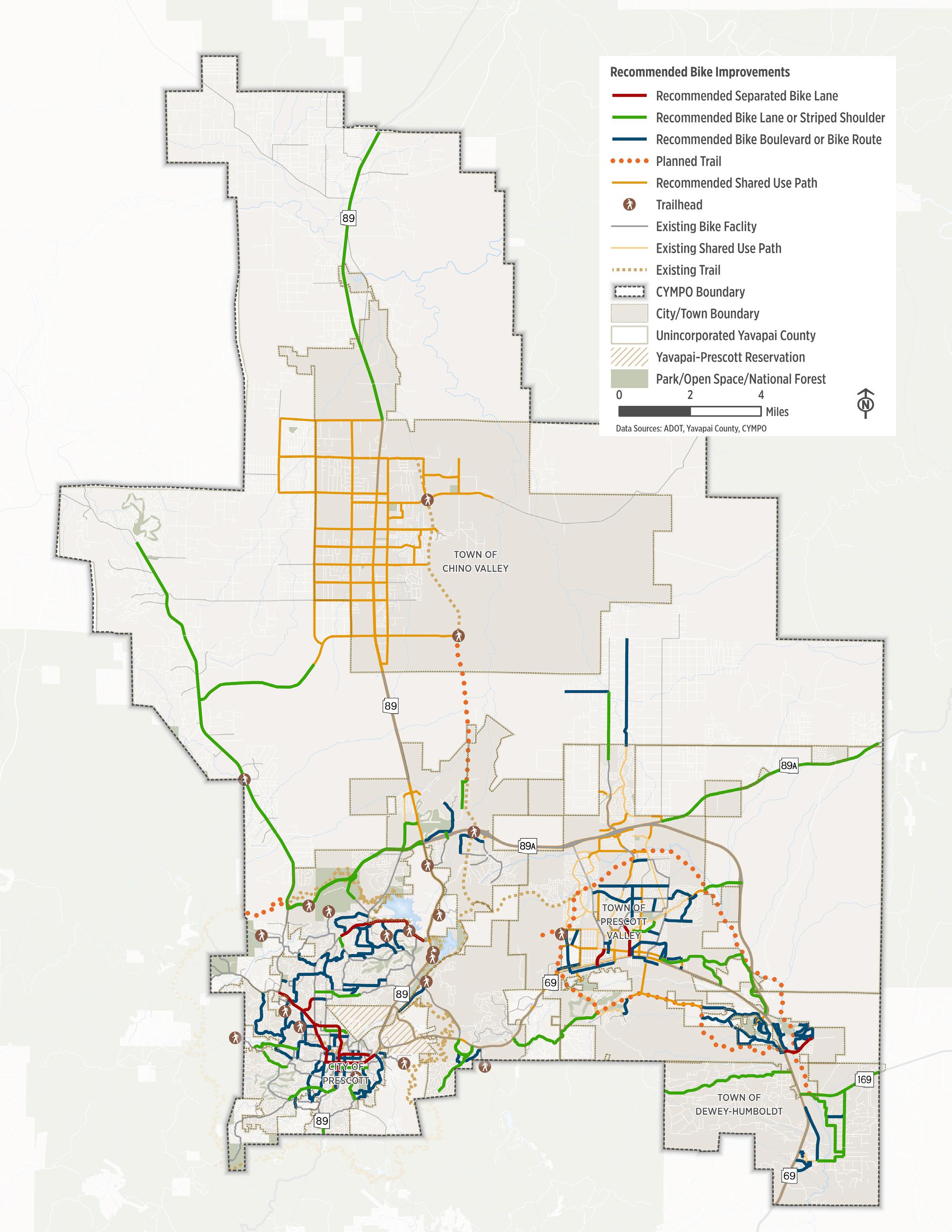
Figure 4.2.
Intersection and Safety Needs
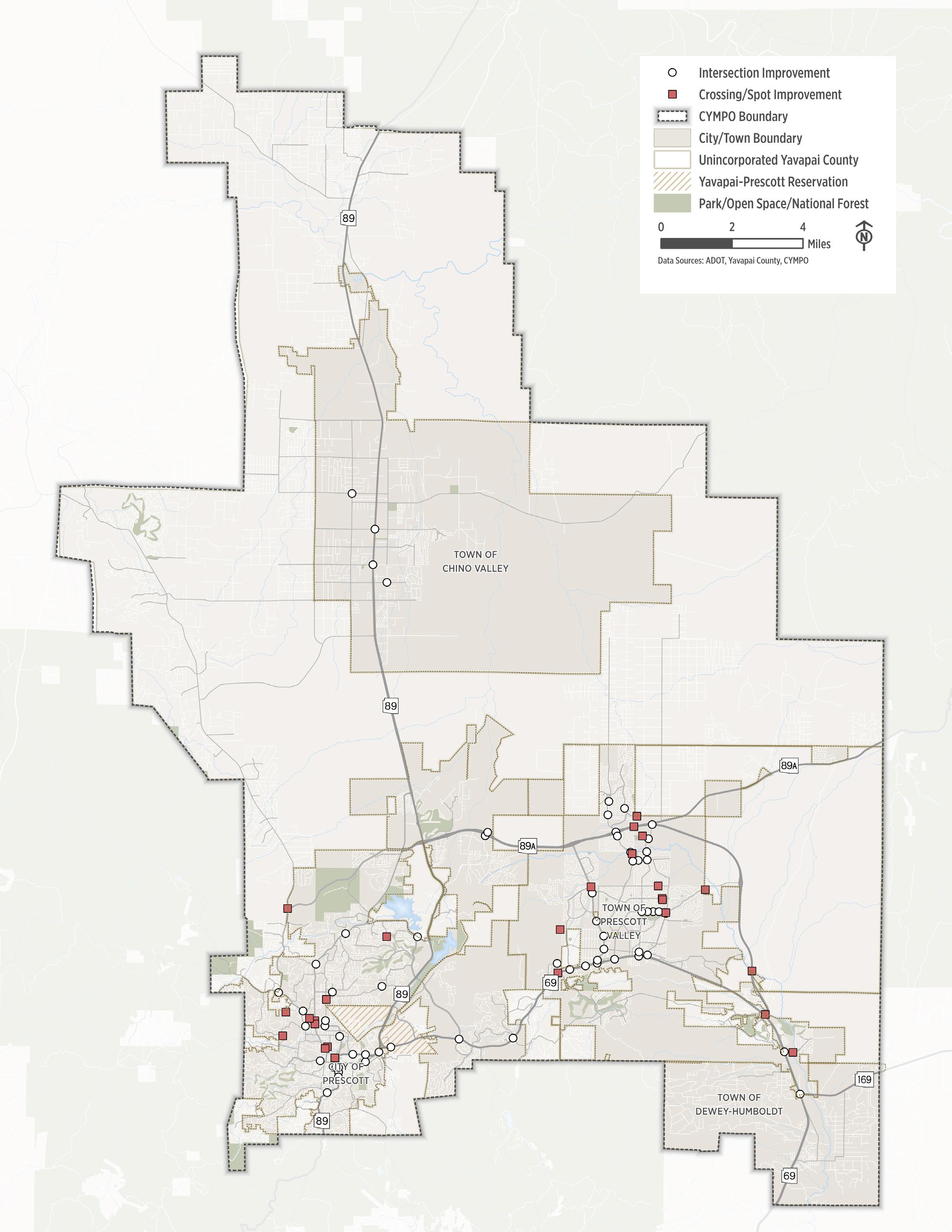
Intersections are critical conflict points for people walking and biking— especially when bike lanes or sidewalks disappear at crossings. Because they are where multiple travel modes converge, intersections often present the greatest risk for conflicts and crashes. Addressing safety and connectivity at these locations is essential to supporting a more comfortable, accessible, and multimodal system.
Safety Treatments at Intersections
Intersections are frequent conflict points between drivers, pedestrians, and bicyclists, requiring targeted design strategies to improve safety and comfort. Enhancing visibility, reducing conflict, and providing consistent infrastructure through intersections can significantly improve the user experience along a corridor. All intersections along the bicycle and pedestrian networks - not just highpriority locations -should be evaluated for potential safety and connectivity upgrades. Recommended treatments include, but are not limited to:
■ Bike Boxes: Position bicyclists ahead of vehicles at signalized intersections for improved visibility.
■ Bicycle Pavement Markings: Indicate the intended path of travel through intersections or across driveways.
■ Curb Extensions: Increase pedestrian visibility, shorten crossing distances, and slow turning vehicles.
■ High-Visibility Crosswalk: increase driver awareness of pedestrian zones.
■ Bicycle Detection: Enables signals to respond to bicycle demand on a given approach.
■ Leading Pedestrian Intervals (LPI): Provides additional time for pedestrians to cross.
■ Protected Intersections: Use physical separation, setback crossings, and dedicated signals to reduce conflicts between turning vehicles and people walking or biking. These treatments work together to create safer, more predictable intersections for all users.
Crossing Improvement Needs
Safe, visible mid-block crossings are critical for pedestrian and bicycle connectivity, especially where intersections are widely spaced or traffic volumes are high. Identified locations may benefit from treatments such as high-visibility crosswalks, Pedestrian Hybrid Beacons (PHBs), or traffic signals. In some cases, overpasses or underpasses may offer the safest and most effective solution.
Equestrian Accommodations
The CYMPO region includes rural and suburban areas where horseback riding remains a valued mode of recreation and transportation. Supporting equestrian use is important for maintaining the region’s character and providing safe, multimodal access for all users. To enhance safety and connectivity for horseback riders, recommended equestrian accommodations include:
■ Equestrian Trail Crossings: At key locations, consider equestrian waiting areas and dual push-button signal actuators, positioned 5 to 6 feet high, to accommodate riders.
■ Trailhead Access: Provide equestrian staging areas at major trailheads to support access to regional routes.
■ Trail Design: Expand trail widths near crossings to form rectangular or fan-shaped waiting zones, allowing horses to safely pause away from traffic.
These improvements help preserve the region’s equestrian-friendly environment while improving safety and comfort for riders.
Figure
5.ImprovementsRecommended
Prioritization of Improvements
This chapter includes a dedicated spread for each local agency, summarizing the recommended multimodal improvements by phase.
It is important to recognize that these recommendations represent the needs only and are not projects. Each need should go through the traditional project development process – detailed project planning, public and stakeholder outreach, project development/preliminary engineering, funding identification, Council approval, project programming, and design; followed by construction. In addition, projects should incorporate facilities for safe equestrian use when appropriate.
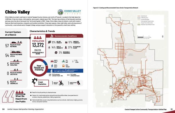
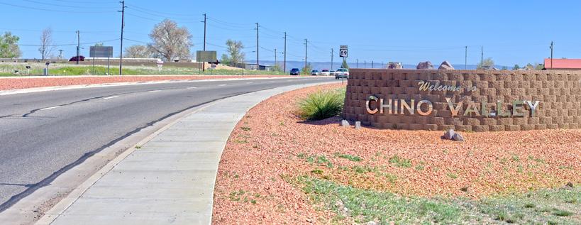
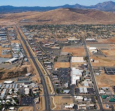
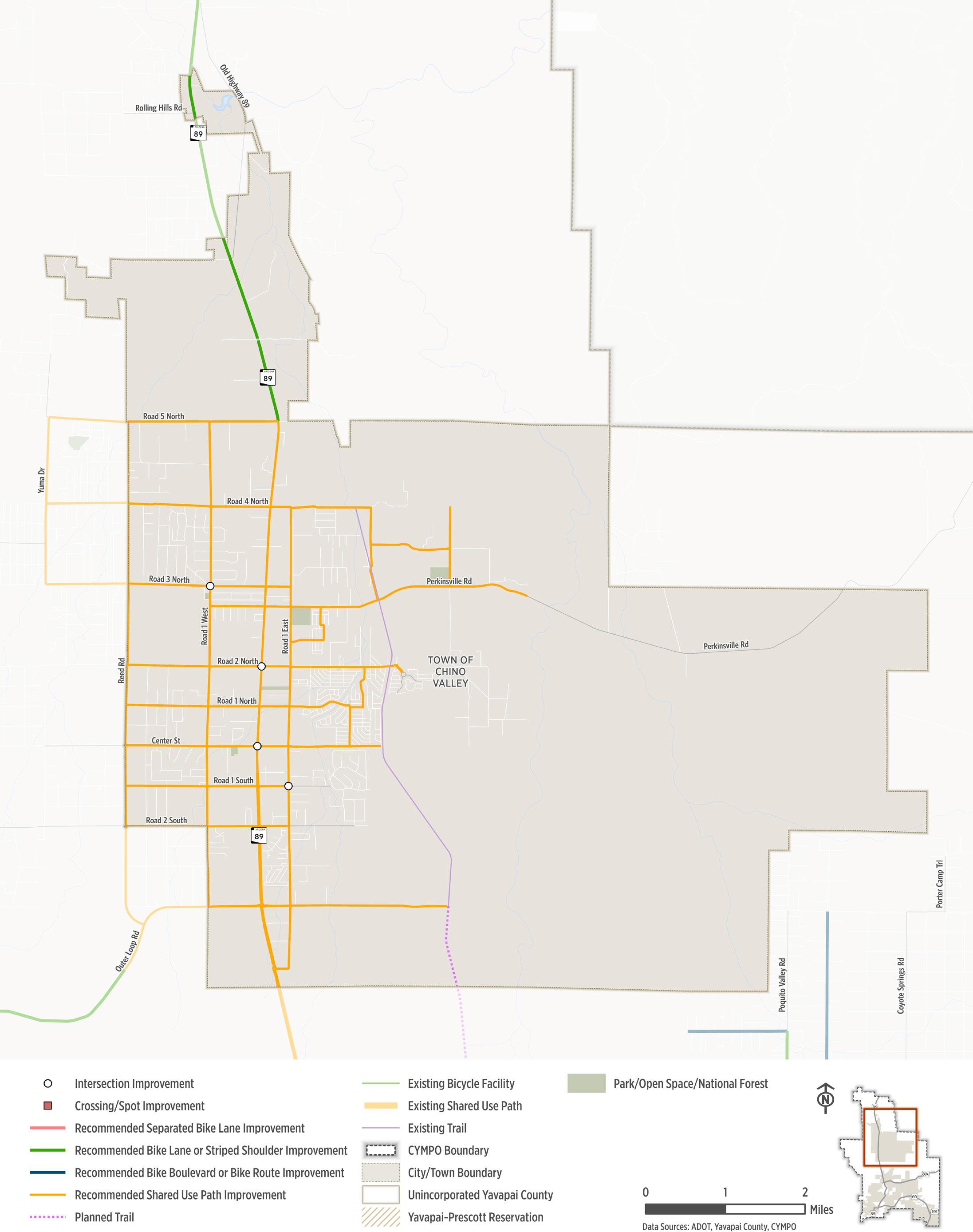
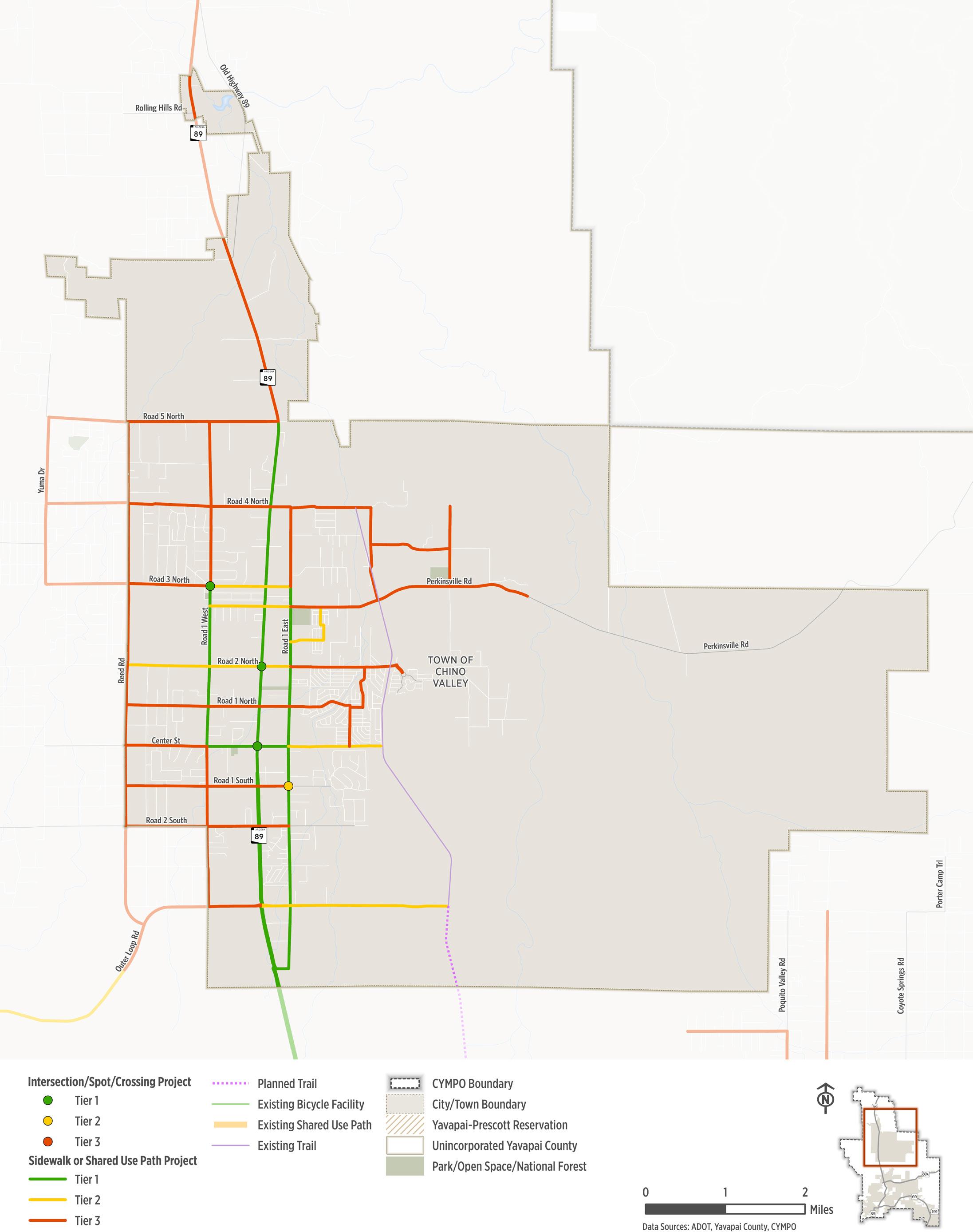
Chino Valley
Chino Valley is a small, rural town in central Yavapai County, Arizona, just north of Prescott. Located in the high desert at 4,656 feet, it has nice views, mild weather, and a quiet, relaxed way of life. The town has a history of farming and ranching and was once the site of Arizona’s first Territorial Capital in 1863. Today, Chino Valley mixes its historic roots with modern features like local breweries, vineyards, and outdoor activities. It has open spaces, clear night skies, and a strong sense of community. Local schools and a Yavapai College campus support education in this peaceful, small-town setting.
Current System at a Glance
Characteristics & Trends
Socioeconomic Conditions
13,372 POPULATION
■ Need for bicycle parking in urbanized areas ■ Support for multimodal options along Arizona Route 89 (e-bikes, low-speed electric scooters, bicycles, pedestrians, hiking, equestrian) ■
Figure
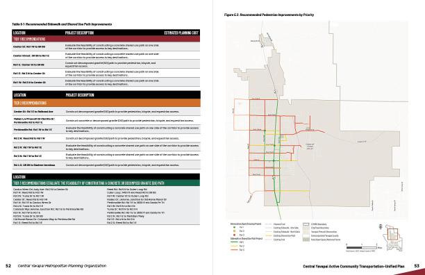
Center St: Rd 1 E to Railroad Ave
E
Perkinsville Rd: Rd 1 W to Rd 1 E
Rd 2 N: Reed Rd to Rd 1 W
Rd 2 N: Rd 1 W to Rd 1 E
Rd 3 N: Rd 1 W to Rd 1 E
Rd 4 S: SR 89 to Eastern terminus
to
and
Construct concrete or decomposed granite (DG) path to provide pedestrian, bicycle, and equestrian access.
Evaluate the feasibility of constructing a concrete shared use path on one side of the corridor to provide access to key destinations.
Construct decomposed granite (DG) path to provide pedestrian, bicycle, and equestrian access.
Evaluate the feasibility of constructing a concrete shared use path on one side of the corridor to provide access to key destinations.
Evaluate the feasibility of constructing a concrete shared use path on one side of the corridor to provide access to key destinations.
Construct decomposed granite (DG) path to provide pedestrian, bicycle, and equestrian access.
Cactus Wren Dr/Judy Ave: Rd 2
to Rd 3 N
Yuma Dr: Rd 5 N to Rd 3 N Perkinsville Rd: Rd 1 E to 2630 ft e/o Santa Fe Trl
Rd 2 N: Rd 1 E to Meridian Pkwy Rd 1 E: Rd 4 N to Rd 3 N Rd 2 S: Reed Rd to Rd 1 E
Construct decomposed granite (DG) path
provide pedestrian, bicycle,
equestrian access.
Mahan Ln/Prescott Dr/Del Rio Dr: Perkinsville Rd to Rd 1
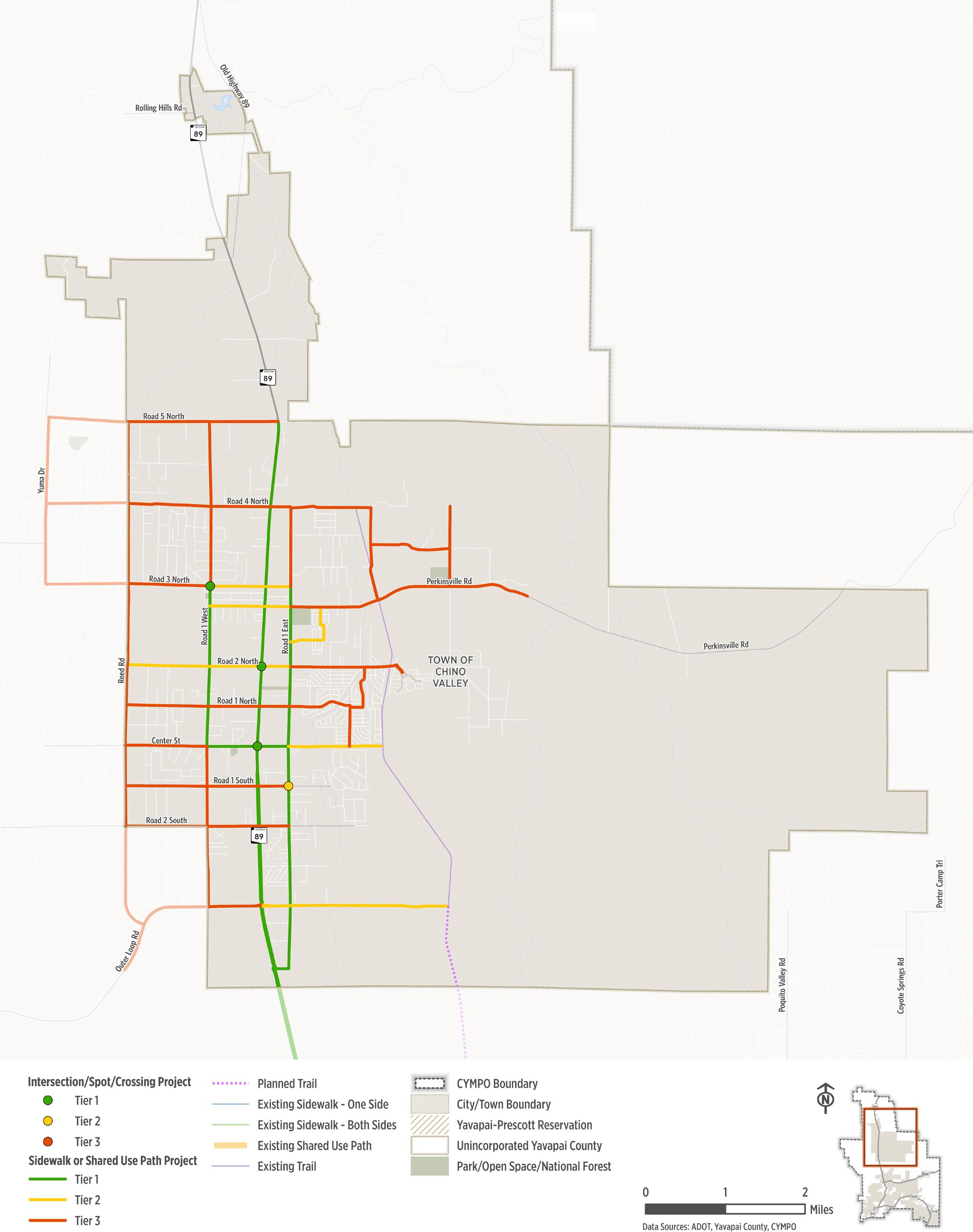
Table 5.2. Recommended Intersection Improvements
Figure
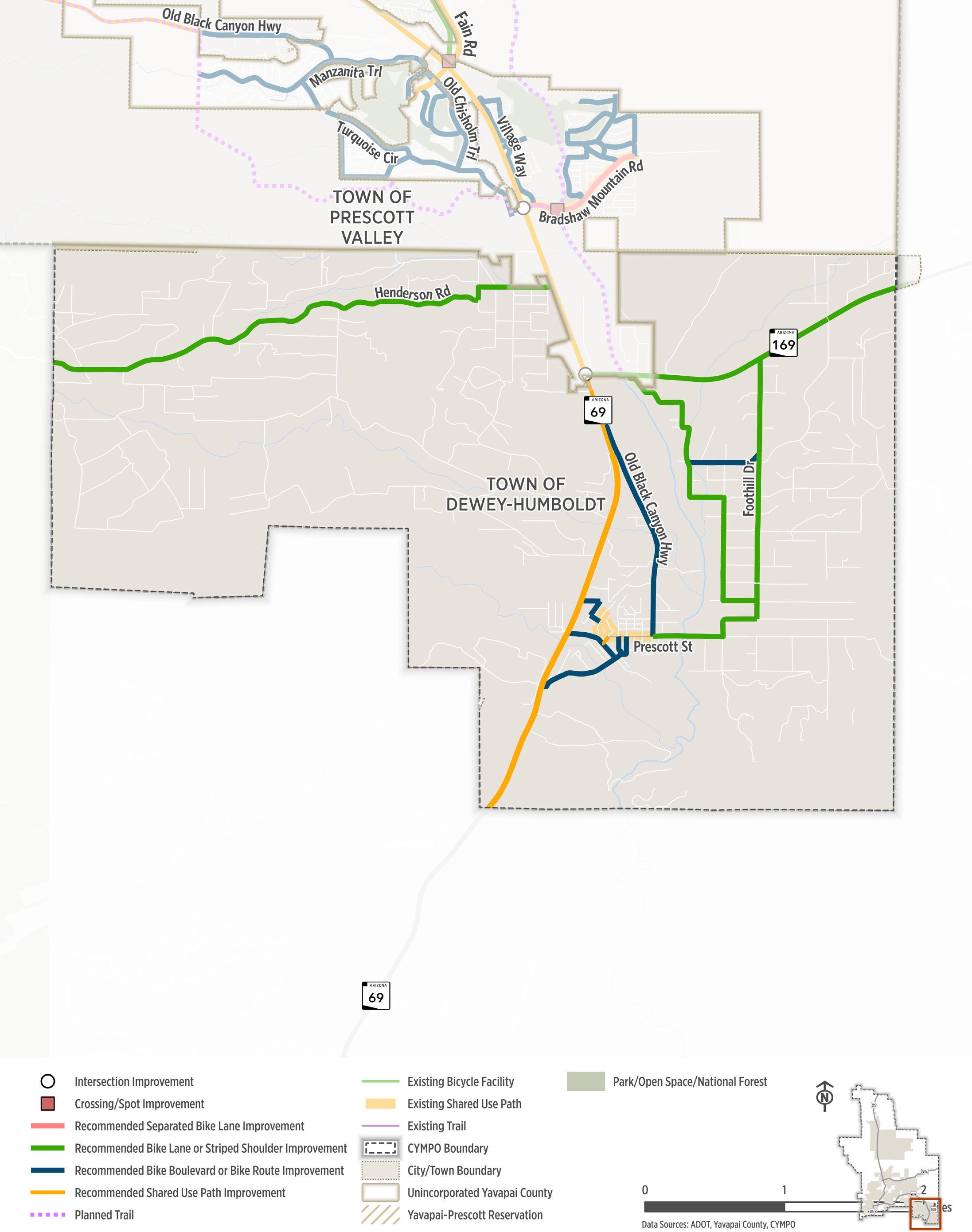
Dewey-Humboldt
Dewey-Humboldt was incorporated in 2004 with a council who is committed to maintaining the rural nature of the area. The Town is located in the high desert of Northern Arizona and is 85 miles north of Phoenix and 12 miles east of Prescott. At an elevation of 4,800 feet, Town residents enjoy a mild 4-season climate.
Current System at a Glance
15
Characteristics & Trends
Socioeconomic Conditions
4,428 POPULATION
9
1
Figure
Old Black Canyon Hwy: Commanche Trl to Prescott St
Construct new sidewalks to provide multimodal access
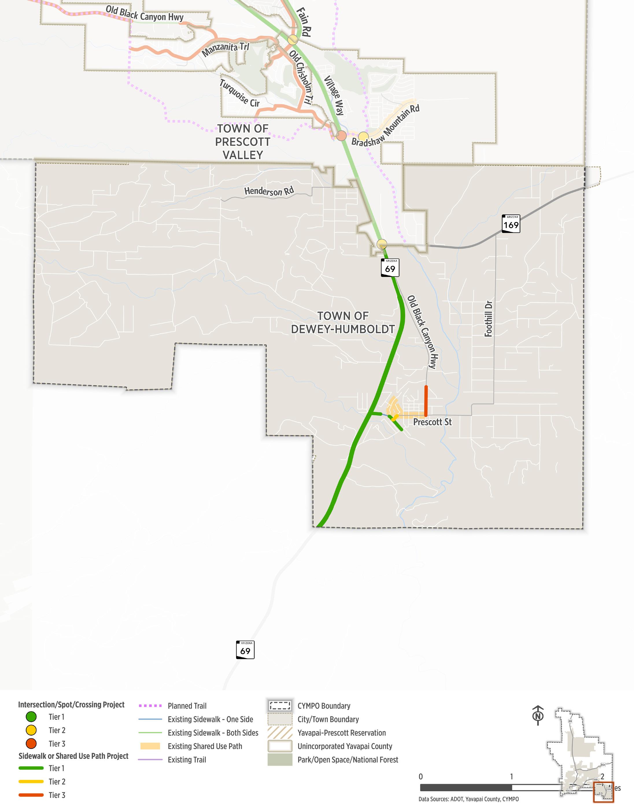
TIER 1 RECOMMENDATIONS
Main St: SR 69 to Third St
Designate as bike route. Evaluate need for traffic calming measures to create a bike boulevard.
$190,000 - $294,000 LOCATION
PROJECT DESCRIPTION
TIER 2 RECOMMENDATIONS
Hecla St: Prescott St to Third St
Hill St: Kloss Ave to Humboldt St
Designate as bike route to aid in creating a network of low-stress bike connections.
Designate as bike route to aid in creating a network of low-stress bike connections.
Humboldt St: Hill St to Huron St Designate as bike route to aid in creating a network of low-stress bike connections.
Kloss Ave: SR 69 to Hill St
TIER 3 RECOMMENDATIONS
Designate as bike route to aid in creating a network of low-stress bike connections.
Bradshaw Rd: Old Black Canyon Hwy to Foothill Dr Widen shoulders to provide space for recreational cyclists. As development occurs, designated bike facilities may be warranted.
Calumet St/Third St: SR 69 to Prescott St Designate as bike route to aid in creating a network of low-stress bike connections.
Deer Pass: SR 169 to Foothill Dr Widen shoulders to provide space for recreational cyclists. As development occurs, designated bike facilities may be warranted.
Foothill Dr: SR 169 to Bradshaw Rd Widen shoulders to provide space for recreational cyclists. As development occurs, designated bike facilities may be warranted.
Henderson Rd: W Town Limits to Pony Pl Widen shoulders to provide space for recreational cyclists. If warranted, install shared use path to increase safety and comfort for riders.
Horseshoe Ln: Henderson Rd to SR 69 Widen shoulders to provide space for recreational cyclists. If warranted, install shared use path to increase safety and comfort for riders.
Old Black Canyon Hwy: SR 69 to Prescott St Designate as bike route to aid in creating a network of low-stress bike connections.
Quarterhorse Ln: River Dr to Foothill Dr Designate as bike route to aid in creating a network of low-stress bike connections.
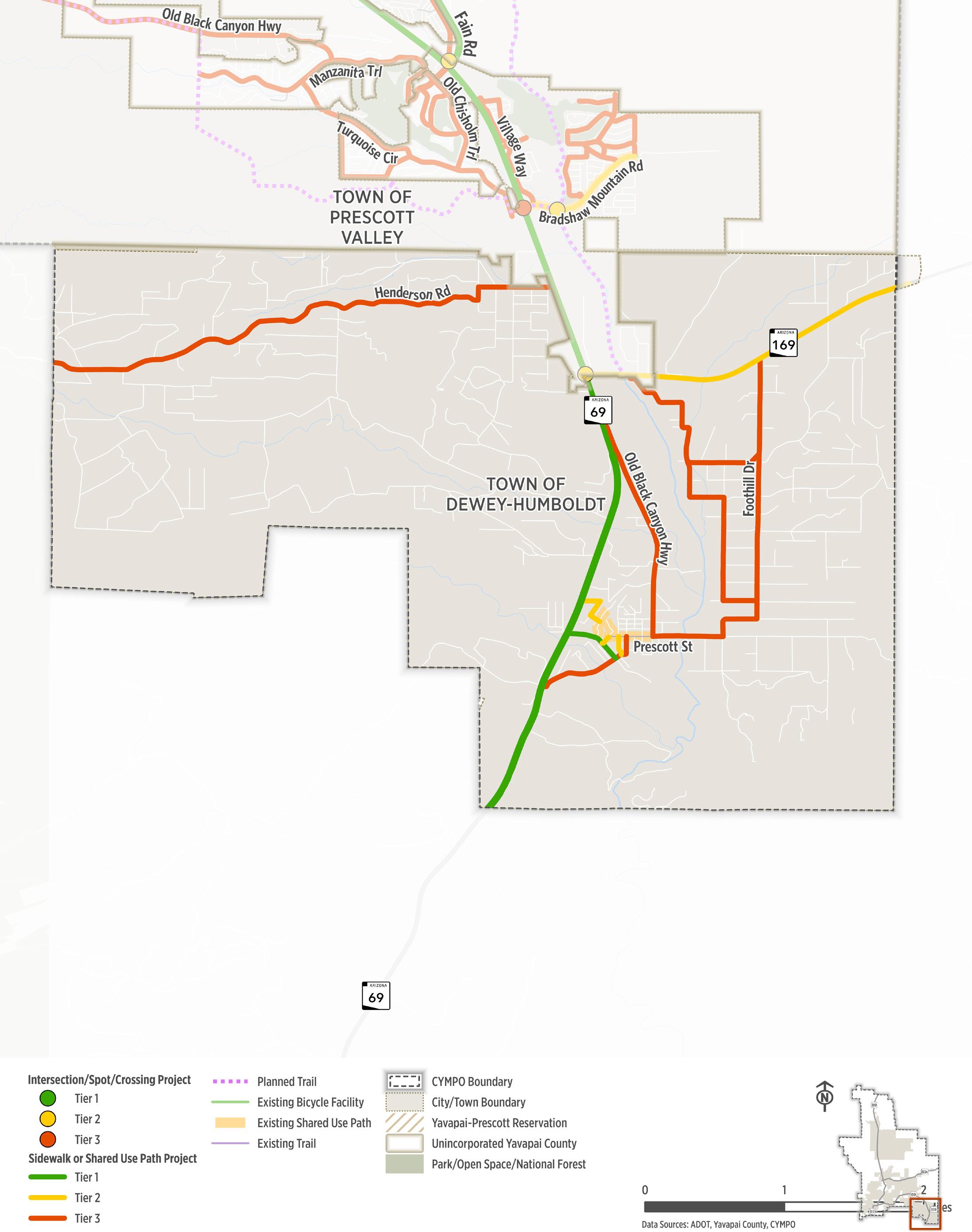
Figure
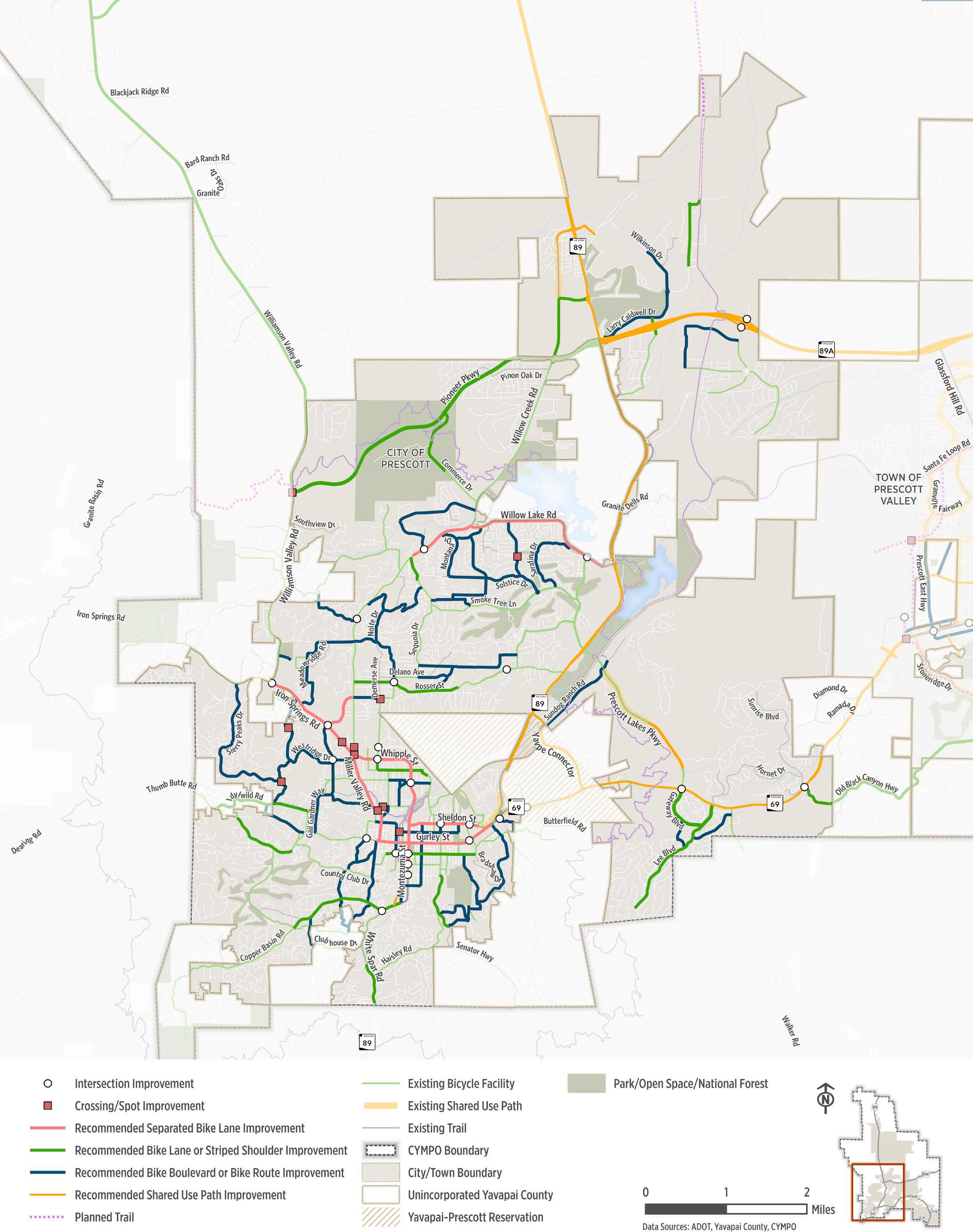
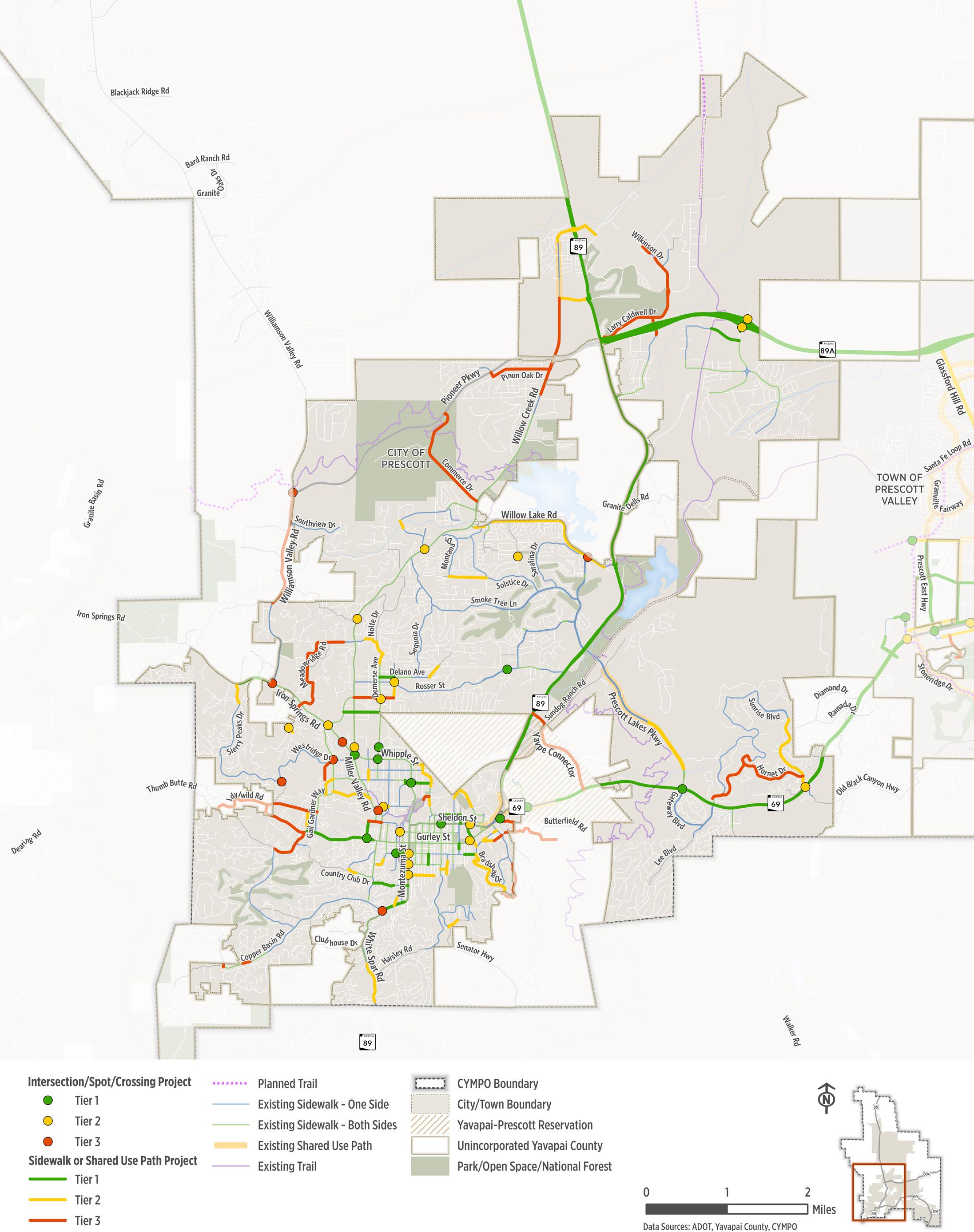
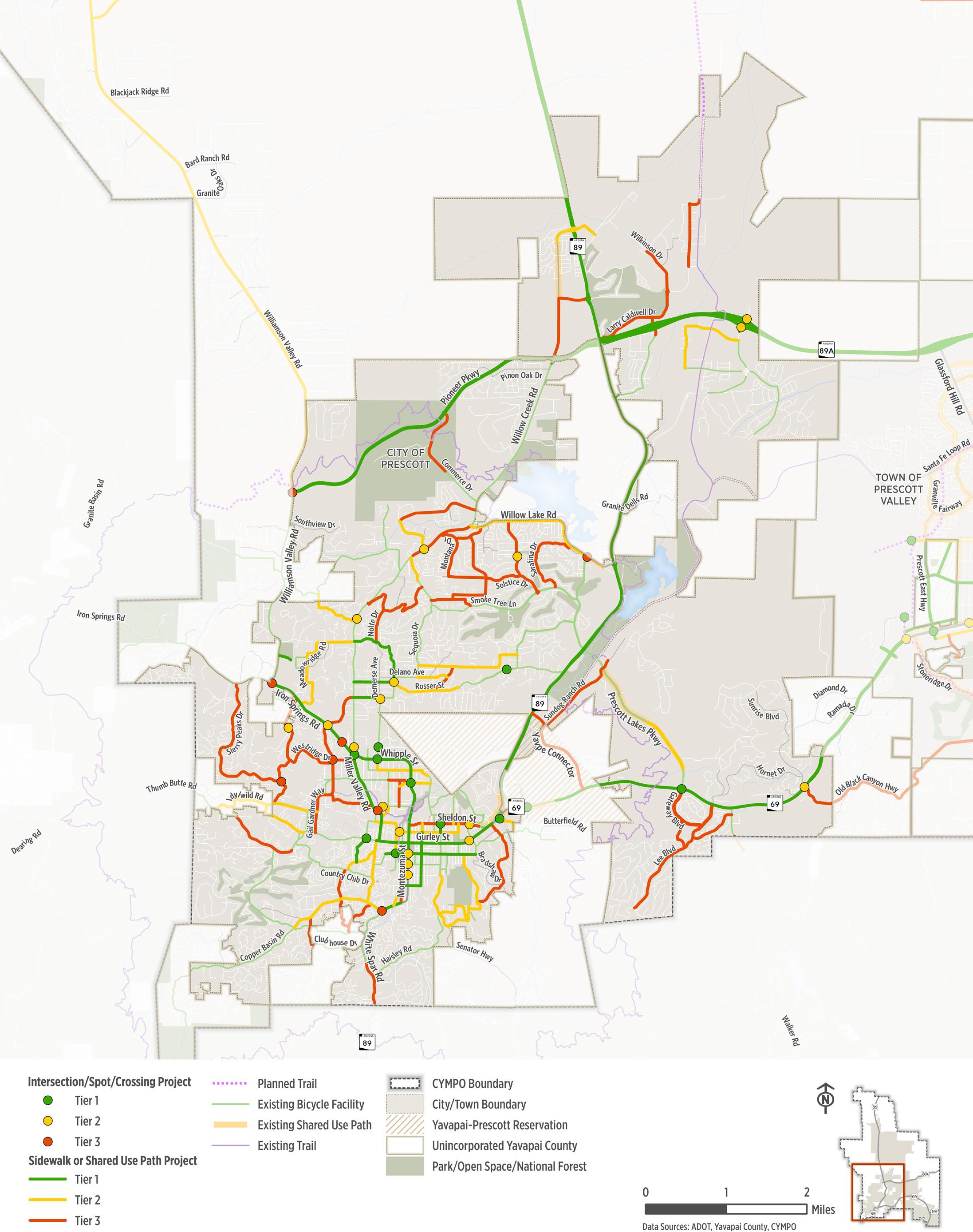
City of Prescott

Prescott is located in the high desert at about 5,200 feet featuring a vibrant blend of Old-West charm and natural beauty. Established in 1864 as the first territorial capital and named for historian William H. Prescott, the city grew into a bustling mining and cattle center. Prescott offers 400 miles of trails, and a national forest with year-round hiking, biking, and horseback riding.
Current System at a Glance
Characteristics & Trends
Socioeconomic Conditions
■ Pedestrian needs: long gaps without crosswalks, limited visibility, and need for more sidewalks.
■ Bicyclist needs: narrow shoulders, lack of dedicated bike lanes, and interest in advisory bike lanes where space is limited.
■ Key destinations: community members want safe access to hotels, churches, retail areas, the courthouse, museums, grocery stores, health centers, and community centers.
Figure
2nd St: Hillside Ave to Navajo Dr
Alarcon St: Goodwin St to Carleton St
Arizona Ave: Gurley St to 350 ft n/o Goodwin St
Arizona Ave: Moeller St to Sheldon St
missing sidewalks to provide continuous pedestrian facilities and to increase access to the school.
the school.
the school.
missing sidewalks to provide continuous pedestrian facilities and to increase access to the school.
Aubrey St: Granite St E to Montezuma St Fill-in missing sidewalks to provide continuous pedestrian facilities and to increase access to the school. $44,605
Centerpointe East Dr: Side Rd to Granite Dells Pkwy
Construct new sidewalks to provide multimodal access to key destinations, including the school.
Delano Ave: Demerse Ave to Campbell Ave Fill-in missing sidewalks to provide continuous pedestrian facilities and to increase access to the school. $168,710
Goodwin St: Penn Ave to Bradshaw Dr
Gurley St: Josephine St to Garden St
Iron Springs Rd: Starry Peaks Dr to Williamson Valley Rd
Leroux St: Park Ave to Montezuma St
Moeller St: Mount Vernon Ave to Arizona Ave
Construct new sidewalks to provide multimodal access to key destinations, including the school. $786,530
Construct new sidewalks to provide multimodal access to key destinations, including the school. $413,461
missing sidewalks to provide continuous pedestrian facilities and to increase access to the school. $324,057
missing sidewalks to provide continuous pedestrian facilities and to increase access to the school. $224,251
Navajo Dr: 3rd St to 6th St Fill-in missing sidewalks to provide continuous pedestrian facilities and to increase access to the school. $216,563 Rush St: 230 ft w/o
Whetstine Ave: Gail Gardner Way to Ruth St
White Spar Rd: Copper Basin Rd to Granite St
Willow St: Sheldon St to Gurley St
missing sidewalks to provide continuous pedestrian facilities and to increase access to the school.
missing sidewalks to provide continuous pedestrian facilities and to increase access to the school. $204,789
LOCATION
TIER 2 RECOMMENDATIONS
5th St/Whipple Ext: 100 ft e/o Whipple St to Merritt St
6th St: 5th St to Granite Creek Park
Aubrey St: 215 ft w/o Cortez St to Pleasant St
Bradshaw Dr: 200 ft s/o Gurley St to Skyview Dr
Campbell Ave: Rosser St to Prescott Heights Dr
Clearwater Dr: Robin Dr to 130 ft n/o Driftwood Ct
Country Club Dr: Coronado Ave to Vista Dr
Delano Ave: Tamarack Ln to Chestnut Dr
Demerse Ave/Douglas Ln: Jupiter Ln to Montebello Ln
Division St: Merritt St to Hillside Ave
Dougherty St: Gail Gardner Way to Gail Gardner Way
Downer Trl: Rockwood Dr to 105 ft s/o Rockwood Dr
Glenwood Ave: 170 ft e/o Park Ave to Hill Ave
James Ln: Willow Creek Rd to SR 89
Josephine St: Oregon Ave to 135 ft n/o Gurley St
Kile St: Adams Ave to 30 ft n/o Adams Ave
Lakeview Dr: Montana Dr to Trail Walk
Madison Ave: Grove Ave to Lincoln Ave
Nathan Ln: Senator Hwy to 750 ft e/o Senator Hwy
Oak St: Mount Vernon Ave to Virginia St
Overstreet Dr: Stetson Rd to Hillcrest Ln
Rodeo Dr: Gail Gardner Way to Miller Valley Rd
Sierry Peaks Dr: Iron Springs Rd to Crossroads
Stetson Rd: Robinson Dr to Daniels Dr
Stetson Rd: Overstreet Dr to Hartin Ave
Sunrise Blvd: Organo Ct to SR 69
Virginia ST: 400 ft s/o Goodwin St to Southern terminus
White Spar Rd: Peterson Ln to Aspen
Whitlow Ave: 520 ft n/o Churchill St to 220 ft n/o Campus Interface Trail
Willow Lake Rd: Lakeview Plaza Ln to Brohner Way
PROJECT DESCRIPTION
Fill-in missing sidewalks to provide continuous pedestrian facilities.
Construct new sidewalks to provide multimodal access
Construct new sidewalks to provide multimodal access to key destinations, including the school.
Construct new sidewalks to provide multimodal access to key destinations, including the school.
Construct new sidewalks to provide multimodal access to key destinations, including the school.
Fill-in missing sidewalks to provide continuous pedestrian facilities.
Fill-in missing sidewalks to provide continuous pedestrian facilities.
Fill-in missing sidewalks to provide continuous pedestrian facilities.
Construct new sidewalks to provide multimodal access
Fill-in missing sidewalks to provide continuous pedestrian facilities.
Fill-in missing sidewalks to provide continuous pedestrian facilities.
Fill-in missing sidewalks to provide continuous pedestrian facilities.
Fill-in missing sidewalks to provide continuous pedestrian facilities and to increase access to the school.
Fill-in missing sidewalks to provide continuous pedestrian facilities.
Fill-in missing sidewalks to provide continuous pedestrian facilities.
Fill-in missing sidewalks to provide continuous pedestrian facilities.
Fill-in missing sidewalks to provide continuous pedestrian facilities.
Fill-in missing sidewalks to provide continuous pedestrian facilities and to connect over the Granite Creek Park Connector
Construct new sidewalks to provide multimodal access
Fill-in missing sidewalks to provide continuous pedestrian facilities.
Construct new sidewalks to provide multimodal access to key destinations, including the school.
Fill-in missing sidewalks to provide continuous pedestrian facilities.
Construct new sidewalks to provide multimodal access
Fill-in missing sidewalks to provide continuous pedestrian facilities.
Fill-in missing sidewalks to provide continuous pedestrian facilities and to increase access to the school.
Construct new sidewalks to provide multimodal access
Fill-in missing sidewalks to provide continuous pedestrian facilities.
Construct new sidewalks to provide multimodal access
Fill-in missing sidewalks to provide continuous pedestrian facilities and to increase access to the school.
Construct new sidewalks to provide multimodal access to key destinations
Figure
LOCATION
TIER 3 RECOMMENDATIONS
5th St: 6th St to Granite Creek Park
Adams Ave: Kile St to Meadowridge Rd
PROJECT DESCRIPTION
Construct new sidewalks to provide multimodal access
Construct new sidewalks to provide multimodal access
Copper Basin Rd: Angelita Dr to Timber Ridge Rd Fill-in missing sidewalks to provide continuous pedestrian facilities.
Dougherty St: Westridge Dr to Eagle Dr
Hillcrest Ln: Overstreet Dr to Robinson Dr
Hornet Dr: Sunrise Blvd to 450 ft n/o Mountain Dr
Idylwild Rd/Oregon Ave: Thumb Butte Rd to Gail Gardner Way
Idylwild Rd: Oregon Ave to Thumb Butte Rd
Larry Caldwell Dr: Larry Caldwell Dr to Assurance Way
Meadowridge Rd/Estrella Rd/Green Ln: Adams Ave to Santa Fe Spring
Pinon Oak Dr: Symphony Dr to Willow Creek Rd
Prescott Heights Dr: Willow Creek Rd to Campbell Ave
Construct new sidewalks to provide multimodal access
Construct new sidewalks to provide multimodal access
Construct new sidewalks to provide multimodal access
Construct new sidewalks to provide multimodal access
Construct new sidewalks to provide multimodal access
Construct new sidewalks to provide multimodal access
Construct new sidewalks to provide multimodal access
Construct new sidewalks to provide multimodal access
Construct new sidewalks to provide multimodal access to key destinations, including the school.
Rancho Vista Dr: 180 ft w/o Mtn Lauren Rd to Copper Basin Rd Fill-in missing sidewalks to provide continuous pedestrian facilities.
Shadow Mountain Dr/Yavapai Hills Dr: Hornet Dr to Touchmark Blvd
Sheldon St: Willow St to Grove Ave
Symphony Dr: Pioneer Pkwy to Pinon Oak Dr
Thumb Butte Rd: Gurley St to Hassayampa Village Ln
Wells Fargo Rd: Wagonwheel Rd to 420 ft s/o Central Terrace Ln
Wilkinson Dr: Melville Rd to Corsair Ave
Wilkinson Dr/Larry Caldwell Dr: Hole in One Dr to Corsair Ave
Willow Creek Rd: James Ln to 280 ft n/o Whispering Rock Rd
Construct new sidewalks to provide multimodal access
Construct new sidewalks to provide multimodal access to key destinations
Construct new sidewalks to provide multimodal access
Construct new sidewalks to provide multimodal access
Construct new sidewalks to provide multimodal access
Construct new sidewalks to provide multimodal access
Construct new sidewalks to provide multimodal access
Construct new sidewalks to provide multimodal access
Goodwin St: Summit Ave to Bradshaw Dr
-
St/Whipple Street: Miller Valley Rd to Sheldon St
Rosser St: Willow Creek Rd to Campbell Ave Install bike lanes in both directions and evaluate the need for traffic calming measures. If space allows, evaluate the potential for a shared use path. $63,000
White Spar Rd: Copper Basin Rd to Granite St Extend
Copper Basin Rd: Hassayampa Village Ln to White Spar Rd
Merritt St/6th St: Ruth St to 400 ft e/o 5th St
Rosser St: Campbell Ave to 150 w/o Piping Rock Rd
Ruth St: Whipple St to Merritt St
Senator Hwy: Aubrey St to Nathan Ln
Smoke Tree Ln: Willow Creek Rd to Meadow Cir
Willow Lake Rd: Prescott Lakes Rd to e/o Meadow Ln
Willow Lake Rd: Willow Creek Rd to Prescott Lakes Pkwy
TIER 3 RECOMMENDATIONS
Commerce Dr: Pioneer Pkwy to 950 ft n/o Tower Rd
Corsair Ave/Melville Rd: Melville Rd to Avenger Rd
Gail Gardner Wy: Willow Creek Rd to Iron Springs Rd
Gateway Blvd: SR 69 to Lee Blvd
James Ln: Willow Creek Rd to SR 89
Larry Caldwell Dr: SR 89A EB Frontage Rd to Assurance Way
Larry Caldwell Dr: E Larry Caldwell Dr to SR 89A EB Frontage Rd
Lee Blvd: SR 69 to Rainbow Ridge Dr
Sheldon St: Montezuma St to Aven Dr
Thumb Butte Rd: Ponderosa Ln to Country Club Dr
Install bike lanes and evaluate the need for traffic calming measures. If space allows, evaluate the potential for widening existing sidewalks to a shared use path.
Install bike lanes and evaluate the need for traffic calming measures.
Install bike lanes and evaluate the need for traffic calming measures. If space allows, evaluate the potential widening the sidewalk to a shared use path.
Install bike lanes and evaluate the need for traffic calming measures.
Install bike lanes and evaluate the need for traffic calming measures. If space allows, evaluate the potential for a shared use path.
Extend bike lanes to create a complete and connected bike network
Evaluate feasibility of constructing a buffered or protected bike facility. If space allows, a shared use path can be constructed on one side to increase safety and comfort for riders.
Evaluate feasibility of constructing a buffered or protected bike facility. If space allows, a shared use path can be constructed on one side to increase safety and comfort for riders.
Widen shoulders to create bike lanes to provide space for cyclists.
Extend bike lanes to create a complete and connected bike network
Evaluate feasibility for buffered or protected bike lanes to provide connectivity to key destinations.
Install bike lanes and evaluate the need for traffic calming measures. If space allows, evaluate the potential for a shared use path.
Extend bike lanes to create a complete and connected bike network
Extend bike lanes to create a complete and connected bike network
Extend bike lanes to create a complete and connected bike network
Install bike lanes and evaluate the need for traffic calming measures. If space allows, evaluate the potential for a shared use path.
Evaluate feasibility of reconfiguring the roadway to incorporate a protected bike facility.
Install bike lanes and evaluate the need for traffic calming measures. If space allows, evaluate the potential for a shared use path.
Walker Rd: Southern Prescott Limits to Ranch Trail Widen shoulders to provide space for recreational cyclists.
White Spar Rd: Peterson Ln to Hidden Valley Rd
Willow Creek Rd: Pioneer Pkwy to James Ln
Willow Creek Rd: Smoke Tree Ln to Willow Lake Rd
Extend bike lanes to create a complete and connected bike network
Extend bike lanes to create a complete and connected bike network
Conduct a corridor assessment to evaluate the community desire and feasibility of reconfiguring the roadway to incorporate a buffered or protected bike facility.
Table 5.7. Recommended Intersection Improvements
Ruth St / Whipple St Perform an engineering evaluation to determine the need and feasibility of upgrading the intersection to incorporate bicycle and pedestrian signalization or other crossing treatments to improve safety.
Montezuma St / Navajo Dr
Ruth St / Sun St
Willow Creek Rd / Whipple St
McCormick St / Goodwin St
Perform an engineering evaluation to determine the need and feasibility of upgrading the intersection to incorporate signalization, bike crossing treatments, high visibility crosswalks, or other crossing treatments to improve safety.
Perform an engineering evaluation to determine the need and feasibility of upgrading the intersection to incorporate signalization, bike crossing treatments, high visibility crosswalks, or other crossing treatments to improve safety.
Perform an engineering evaluation to determine the need and feasibility of upgrading the intersection to incorporate a pedestrian overpass or underpass, bike detection, or other crossing treatments to improve safety.
Perform an engineering evaluation to determine the need and feasibility of upgrading the intersection to incorporate bike crossing treatments, high visibility crosswalks, pedestrian lighting, or other crossing treatments to improve safety.
Mount Vernon Ave / Sheldon St Perform an engineering evaluation to determine the need and feasibility of upgrading the intersection to incorporate PHB, bike crossing treatments, high visibility crosswalks, or other crossing treatments to improve safety.
2 RECOMMENDATIONS
Prescott Heights Dr / Demerse Ave Construct path from Demerse Ave to Prescott Height Dr to increase multimodal connectivity
Kile St / Downer Trail Pave corridor segment
Madison Ave / Granite Park Connector Construct ped/bike crossing over Miller Creek
Samaritan Way / St Enodoc Cr Construct path to connect Samaritan and St Enodoc
Granite Dells Pkwy / SR 89 EB As development occurs, incorporate high quality pedestrian and bicycle crossing treatments, including high visibility crosswalks and protected bike facilities
Granite Dells Pkwy / SR 89 WB As development occurs, incorporate high quality pedestrian and bicycle crossing treatments, including high visibility crosswalks and protected bike facilities
Rush St / Gurley St
Willow Creek Rd / btwn Ainsworth Dr and Whipple St
Crossings Dr / Willow Creek Rd
Willow Creek Rd / Country Park Dr
Willis St / btwn McCormick St and Granite St
Old Black Canyon Hwy / SR 69
Campbell Ave / Rosser St
Rush St / Sheldon St
Montezuma St / Carleton St
Montezuma St / Goodwin St
Montezuma St / Aubrey St
Iron Springs Rd / Gail Gardner Way
Perform an engineering evaluation to determine the need and feasibility of upgrading the intersection to incorporate a mid-block crossing, signalization, bike crossing treatments, or other crossing treatments to improve safety.
Perform an engineering evaluation to determine the need and feasibility of upgrading the intersection to incorporate a mid-block crossing, signalization, bike crossing treatments, or other crossing treatments to improve safety.
Perform an engineering evaluation to determine the need and feasibility of upgrading the intersection to incorporate bike crossing treatments, high visibility crosswalks, or other crossing treatments to improve safety.
Perform an engineering evaluation to determine the need and feasibility of upgrading the intersection to incorporate bicycle and pedestrian signalization or other crossing treatments to improve safety.
Perform an engineering evaluation to determine the need and feasibility for a mid-block crossing to connect the Granite Creek Trail
Conduct project assessment to identify and implement intersection safety improvements
Upgrade intersection to include sidewalks and pedestrian crossing facilities
Perform an engineering evaluation to determine the need and feasibility of upgrading the intersection to incorporate bike crossing treatments, high visibility crosswalks, or other crossing treatments to improve safety.
Perform an engineering evaluation to determine the need and feasibility of upgrading the intersection to incorporate bike crossing treatments
Perform an engineering evaluation to determine the need and feasibility of upgrading the intersection to incorporate bike crossing treatments
Perform an engineering evaluation to determine the need and feasibility of upgrading the intersection to incorporate signalization, bike crossing treatments, high visibility crosswalks, or other crossing treatments to improve safety.
Perform an engineering evaluation to determine the need and feasibility of upgrading the intersection to incorporate bike crossing treatments, high visibility crosswalks, or other crossing treatments to improve safety.
LOCATION
TIER 3 RECOMMENDATIONS
PROJECT DESCRIPTION
Downer Trail / Sierry Peaks Dr Open connection between Sierry Peaks Dr and Downer Trl Grove Ave / btwn Garden St and Madison Ave
Copper Basin Rd / Whitespar Road (SR89)
Gail Gardner Way / Whipple St
Prescott Lakes Pkwy / Willow Lake Rd
Williamson Valley Rd / Iron Springs Rd
Iron Springs Rd / btwn Haining St and Ainsworth Dr
Perform an engineering evaluation to determine the need and feasibility of upgrading the intersection to incorporate a mid-block crossing, signalization, bike crossing treatments, or other crossing treatments to improve safety.
Conduct project assessment to identify and implement intersection safety improvements
Perform an engineering evaluation to determine the need and feasibility of upgrading the intersection to incorporate signalization, bike detection, or other crossing treatments to improve safety.
Perform an engineering evaluation to determine the need and feasibility of upgrading the intersection to incorporate bicycle and pedestrian signalization or other crossing treatments to improve safety.
Perform an engineering evaluation to determine the need and feasibility of upgrading the intersection to incorporate bike crossing treatments, high visibility crosswalks, or other crossing treatments to improve safety.
Perform an engineering evaluation to determine the need and feasibility of a mid-block crossing and RRFB
Low-Stress Connections
To provide a low stress route for bicyclists, incorporate traffic calming elements along these corridors with low posted speed limits and traffic volumes to help create and maintain a more comfortable bicycling experience for people of all ages and abilities.
Table 5 .8 illustrates potential slow streets that provide direct and convenient access to the wider regional bicycle network.
Table 5.8. Recommended Low Stress Connections
LOCATION
TIER 1 RECOMMENDATIONS
Carleton St/Granite St: Montezuma St to Leroux St
Douglas Ln/Vista Del Cerro St: Willow Creek Rd to Miramonte Dr
Granite Mountain School: Williamson Valley Rd to East terminus
Leroux St: Granite St to Marina St
Marina St: Willis St to Leroux St
TIER 2 RECOMMENDATIONS
Arizona Ave: Sheldon St to Willis St
Autumn Breeze Rd/Nathan Ln: Acker Park to Senator Hwy
Centerpointe East Dr: Granite Dells Pkwy to Dells Ranch Rd
Chestnut Dr: Sequoia Dr to Cedarwood Dr
Clearwater Dr/Crossings Dr: Robin Dr to Willow Creek Rd
Coronado Ave: Park Ave to Country Club Dr
Country Park Dr/Pine Cove Rd: Sylvan Dr to Willow Creek Rd
Haisley Rd/Grand Valley/Summer Field: Senator Hwy to Autumn Breeze
Hillcrest Dr/Eastwood Dr/Nevada Dr/Devereaux Dr: Goodwin St to Autumn Breeze
Idylwild Rd: Idylwild Rd to Thumb Butte Rd
TIER 3 RECOMMENDATIONS
1st St: Hillside Ave to Madison Ave
Cedarwood Dr: Tamarack Ln to Rosser St
Cherokee Rd: Copper Basin Rd to Canyon Dr
Downer Trl: Adams Ave to Westridge Dr
Downer Trl/Westridge Dr: Gail Gardner Way to Oregon Ave
Fairground Ave/Schemmer Dr: Gail Gardner Way to Miller Valley Rd
Gail Gardner Way: Iron Springs Rd to Gurley St
Golden Bear Dr/Golden Hawk Dr: Smoke Tree Ln to Smoke Tree Ln
Granite St: Leroux St to White Spar Rd
Hemlock Ave: Copper Basin Rd to Arroyo Dr
Highland Ave: Country Club Dr to Copper Basin Rd
Hillside Ave: Lincoln Ave to Navajo Dr
Kile St/Downer Trl: <Null> to <Null>
Lakeview Dr: Montana Dr to Smoke Tree Ln
Lakeview Dr/Peace Pipeline: Trail Walk to Golden Hawk Dr
Larry Caldwell Dr: Hole in One Dr to Corsair Ave
Mount
Prescott Heights Dr: Willow Creek Rd to Demerse Ave
Whetstine Ave: Gail Gardner Way to Demerse Ave
Willow St: Gurley St to Coronado Ave
to
McCormick St/Sheldon St: Garden St to Gurley St
Meadowridge Rd: Iron Springs Rd to Willow Creek Rd
Navajo Dr: 1st St to 6th St
Overland Rd: SR 69 to Butterfield Rd
Park Ave: Gurley St to Copper Basin Rd
Tamarack Ln/Bloomingdale Dr: Sequioa Dr to Blooming Hills Dr
Washington Ave: Moeller St to Sheldon St
Willis St: Granite St to Arizona Ave
Mogollon Rd: Willow Lake Rd to Montana Dr
Montana Dr: Willow Creek Rd to Lakeview Dr
Morning Glow Way/Future Street Connection: Gateway Blvd to Lee Blvd
Nolte Dr: Willow Creek Rd to Douglas Ln
Pine Knoll Dr: Copper Basin Rd to Cherokee Rd
Robin Dr: Clearwater Dr to Willow Creek Rd
Robinson Dr/McDonald Dr: Gurley St to Eastwood Dr
Samaritan Way: Willow Lake Rd to Harvest Ln
Sandia Dr/Valley Pl/Tabosa Dr: Nolte Dr to Smoke Tree Ln
Sarafina Dr: Willow Lake Rd to Smoke Tree Ln
Sierry Peaks Dr: Iron Springs Rd to Downer Trl
St Enodoc Cir: Vista Park to Solstice Dr
Sundog Ranch Rd: Stormranch Rd to Yavapai Connector
Trail Walk: Mogollon Rd to Lakeview Dr
Whipple St: Gail Gardner Way to Miller Valley Rd
Wilkinson Dr: Cirrus Dr to Corsair Ave
Miramonte Dr: Vista Del Cerro St to Delano Ave
Vernon Ave: Moeller St to Willis St
Lincoln Ave/Madison Ave: Miller Creek to Grove Ave
Marina St: Sheldon St
Willis St
Prescott Valley
Prescott Valley is a vibrant, fast-growing community located at an elevation of 5,100 feet between the Bradshaw and Mingus Mountains in central Arizona. Known for its family-friendly atmosphere and high quality of life, the town offers a dynamic mix of cultural, recreational, and educational opportunities. Residents enjoy over 20 well-maintained parks, modern infrastructure, diverse housing options, and a strong sense of community. Just minutes from historic Prescott and with easy access to Flagstaff, Sedona, and the Phoenix area, Prescott Valley is well-positioned for both convenience and adventure.
Current System at a Glance
Characteristics & Trends
Socioeconomic Conditions
■ Desire for improved bike infrastructure, including bike parking, advisory bike lanes, and better shoulder access for walking and biking
■ Concern about narrow two-lane roads that need widening to accommodate sidewalks and dedicated bike lanes
■ Interest in expanding the Prescott Valley trail system, including connectors to existing trails ■ Requests for more
and
Figure
Table 5.9. Recommended Sidewalk and Shared Use Path Improvements
Civic Dr: Windsong Dr to Skoog Blvd
Florentine Rd:Glassford Hill Rd to Mendecino Dr
to Truwood
Glassford Hill Rd: Main St to Veterans Way
Construct new sidewalks to provide multimodal access to key destinations, including the school. Recommended in the Prescott Valley SS4A Study.
Lake Valley Rd: Lakeshore Dr to SR 69
Lake Valley Rd:Florentine Rd to 2nd St
Lakeshore Dr: Glassford Hills Rd to Windsong Dr
Lone Cactus Dr:Spouse Dr to Long Look Dr
Construct MUP on the west side of the corridor and sidewalks on the east to provide multimodal access to key destinations, including the school. Recommended in the Prescott Valley SS4A Study. $681,000
Construct shared use path to fill-in gap in the overall shared use path network. $2,755,373
Construct MUP on the north side of the corridor and sidewalks on the south to provide multimodal access to key destinations, including the school. Recommended in the Prescott Valley SS4A Study.
$2,932,739
Construct shared use path to fill-in gap in the overall shared use path network. $897,000
Loos Dr: Long Look Dr to Robert Rd Fill-in missing sidewalks to provide continuous pedestrian facilities and to increase access to the school. $650,029
Market ST: Crownpointe Dr to Sundog Ranch Rd Fill-in missing sidewalks to provide continuous pedestrian facilities. $266,347
Navajo Dr:Lakeshore Dr to 150 ft n/o Navajo Ct
Robert Rd: Roundup Dr to Tranquil Blvd
Construct shared use path to fill-in gap in the overall shared use path network. $99,000
Evaluate feasibility to install sidewalks on both side of the road or a shared use path on one side. $940,907
Robert Rd: SR 69 to Frontage Rd Fill-in missing sidewalks to provide continuous pedestrian facilities. $34,089
Robert Rd:Fain Rd to Powers Ave Construct shared use path to fill-in gap in the overall shared use path network. $472,000
Robert Rd:Manley Dr to Frontage Rd (south)
Evaluate feasibility of widening sidewalks to a shared use path to provide increased safety for pedestrian and cyclists. Project identified in the Prescott Valley SS4A Study. $2,211,000
Roundup Dr:Viewpoint Dr to Robert Rd Construct shared use path to fill-in gap in the overall shared use path network. $518,000
Skoog Blvd:Lakeshore Dr to Lakeshore Dr
Starlight Dr:Sunset Ln to Frontage Rd
Sundog Ranch Rd:Market St to Cracker Barrel Dwy
Evaluate feasibility of widening sidewalks to create a shared use path. Consider incorporating into planning and design for future path along Skoog Blvd. $523,000
shared use path to fill-in gap in the overall shared use path network. $494,000 Sunset Ln:Castle Dr to Pine View Dr
Viewpoint
830
feasibility of widening sidewalks to create a shared use path $1,116,000
Viewpoint Dr:Long Look Dr to Skoog Blvd Evaluate feasibility of widening sidewalks to create a shared use path $332,000
Viewpoint Dr:Park View Dr to SR 89
Viewpoint Dr:SR 89 to Acorn Cir
shared use path to fill-in gap in the overall shared use path network. $1,452,000
shared use path gaps to provide a continuous path from SR 89A to Downtown Prescott Valley $541,000
LOCATION
TIER 2 RECOMMENDATIONS
2nd St: 8th St to Lake Valley Rd
2nd St: 445 ft w/o Prescott East Hwy to Glassford Hill Rd
Bradshaw Mountain Rd: Turquoise Cir to SR 69
Copper Hill Dr: 180 ft e/o Great Western Dr to Starlight Dr
Frontage Rd: Yavapai Rd to Eastridge Dr
Frontage Rd: 275 ft w/o Lake Valley Rd to Windsong Dr
Glassford Hill Rd: SR 89 to 435 ft n/o Long Look Dr
Lakeshore Dr: Tani Rd to 620 ft n/o Warren Rd
Long Look Dr: 660 ft e/o Verde Vista Dr to Tonto Way
Long Mesa Dr: Viewpoint Dr to Ranger Rd
Manley Dr: Lone Cactus Dr to Ranger Rd
PROJECT DESCRIPTION
Fill-in missing sidewalks to provide continuous pedestrian facilities.
Fill-in missing sidewalks to provide continuous pedestrian facilities and to increase access to the school.
Fill-in missing sidewalks to provide continuous pedestrian facilities and to increase access to the school.
Construct new sidewalks to provide multimodal access to key destinations, including the school.
Construct new sidewalks to provide multimodal access
Fill-in missing sidewalks to provide continuous pedestrian facilities.
Evaluate the feasibility to construct sidewalks or a shared use path to connect neighborhoods to key destinations. Recommended in the Prescott Valley SS4A Study. Incorporate as part of corridor widening project.
Fill-in missing sidewalks to provide continuous pedestrian facilities and to increase access to the school.
Fill-in missing sidewalks to provide continuous pedestrian facilities and to increase access to the school.
Construct new sidewalks to provide multimodal access
Construct new sidewalks to provide multimodal access
Spouse Dr: Glassford Hill Rd to Ranger Rd Fill-in missing sidewalks to provide continuous pedestrian facilities.
Valley Rd: Navajo Dr to Mendecino DR
Valley View Dr: Frontage Rd to 2nd St
Viewpoint Dr: 500 ft n/o Custer Cir to 220 ft s/o Custer Cir
Windsong Dr: Lakeshore Dr to 310 ft w/o Lakeshore Dr
Yavapai Rd: Frontage Rd to Florentine Rd
Addis Ave:Winchester Dr to Cattletrack Dr
Antelope Ln:Castle Dr to Starlight Dr
Antelope Meadows Dr/Coyote Springs Rd:1500 ft w/o Coyote Springs Rd to SR 89A
Bronco Ln:Granville Pkwy to Winchester Dr/Roundup Dr
Lakeshore Dr:Bridger Rd to Serpentine Ln
Pronghorn Ranch Pkwy:West terminus to Antelope Meadows Dr
Roundup Dr:Winchester Dr to Viewpoint Dr
Winchester Dr:Addis Ave to Roundup Dr
Evaluate feasibility to install sidewalks.
Construct new sidewalks to provide multimodal access to key destinations, including the school.
Fill-in missing sidewalks to provide continuous pedestrian facilities.
Construct sidewalks on the west side of the road. Recommended in the Prescott Valley SS4A Study.
Construct new sidewalks to provide multimodal access to key destinations, including the school.
Evaluate feasibility to install sidewalks on both side of the road or a shared use path on one side.
Construct shared use path to fill-in gap in the overall shared use path network.
Construct shared use path to fill-in gap in the overall shared use path network.
Construct shared use path to fill-in gap in the overall shared use path network.
Construct shared use path to fill-in gap in the overall shared use path network.
Install shared use path or sidewalks to provide multimodal connectivity
Evaluate feasibility to install sidewalks on both side of the road or a shared use path on one side.
Evaluate feasibility to install sidewalks on both side of the road or a shared use path on one side.
LOCATION
TIER 3 RECOMMENDATIONS
5th St: 2nd St to Southern terminus
Bob Dr: Yavapai Rd to Navajo Dr
Cattletrack Dr: Addis Ave to Roundup Dr
Hondo Dr: Long Mesa Dr to Ranger Rd
Mendecino Dr: Florentine Rd to SR 69
Navajo Dr: Existing southern terminus to Old Black Canyon Hwy
Park View Dr: Copperfield Dr to btwn Park Ridge Dr and Viewpoint Dr
Ranger Rd: Hondo Dr to Outrider Ct
Tonto Way: Manley Dr to Long Look Dr
Truwood Rd: Yavapai Rd to SR 69
PROJECT DESCRIPTION
Install shared use path or sidewalks to provide multimodal connectivity
Construct new sidewalks to provide multimodal access
Evaluate feasibility to install sidewalks on both side of the road or a shared use path on one side.
Construct new sidewalks to provide multimodal access
Install shared use path or sidewalks to provide multimodal connectivity
Construct shared use path to fill-in gap in the overall shared use path network.
Construct shared use path to fill-in gap in the overall shared use path network.
Construct new sidewalks to provide multimodal access
Construct new sidewalks to provide multimodal access to key destinations
Construct new sidewalks to provide multimodal access to key destinations, including the school.
Glassford Hill Rd: Florentine Rd to 2nd St
Enterprise Pkwy:
Orchard Ct: Magnolia Way to Fain Rd Widen shoulders to provide space for recreational cyclists.
Sarah Jane Ln: Valley Rd to Fain Rd Widen shoulders to provide space for recreational cyclists.
Valley Rd: Truwood Dr to Magnolia Way Widen shoulders to provide space for recreational cyclists.
Bradshaw Mountain Rd: SR 69 to Villa St As demand increases,
lane.
Lakeshore Dr: Badger Rd to Fain Rd
Windsong Dr: Long Look Dr to SR 69
Figure
Table 5.11. Recommended Intersection Improvements
Hoffman Rd / Loos Dr
Katie Circle / Loos Dr
Robert Rd / Powers Ave
Perform an engineering evaluation to determine the need and feasibility of upgrading the intersection to incorporate RRFB, bike crossing treatments, high visibility crosswalks, or other crossing treatments to improve safety.
Upgrade intersection to include sidewalks and pedestrian crossing facilities. Investigate incorporating project into school expansion.
Perform an engineering evaluation to determine the need and feasibility of upgrading the intersection to incorporate PHB, bike crossing treatments, high visibility crosswalks, or other crossing treatments to improve safety.
Robert Rd / Loos Dr Upgrade intersection to include sidewalks and pedestrian crossing facilities
Glassford Hill Rd / Florentine Rd Upgrade intersection to include sidewalks and pedestrian crossing facilities
Lake Valley Rd / SR 69 Conduct project assessment to identify and implement intersection safety improvements
Prescott E Hwy / SR 69
project assessment to identify and implement intersection safety improvements
Glassford Hill Rd / SR 69 Conduct project assessment to identify and implement intersection safety improvements
Navajo Dr / Lakeshore Dr
/ Loos Dr
Perform an engineering evaluation to determine the need and feasibility of upgrading the intersection to incorporate RRFB, bike crossing treatments, high visibility crosswalks, or other crossing treatments to improve safety.
intersection to include sidewalks and pedestrian crossing facilities
Glassford Hills Rd / Long Look Dr Upgrade intersection to include sidewalks and pedestrian crossing facilities
Roundup Dr / Viewpoint Dr
Perform an engineering evaluation to determine the need and feasibility of upgrading the intersection to incorporate PHB, bike crossing treatments, high visibility crosswalks, or other crossing treatments to improve safety. $201,000
Viewpoint Dr / Addis Ave Upgrade intersection to include sidewalks and pedestrian crossing
Navajo Dr / Valley Rd
Jasper Pkwy and Summit Trail
Antelope Meadows Dr/ e/o
Robin Nest Ct (Future Pipeline Trail Phase 4 connection)
Perform an engineering evaluation to determine the need and feasibility of upgrading the intersection to incorporate a RRFB, bike crossing treatments, high visibility crosswalks, or other crossing treatments to improve safety.
$60,000
Perform an engineering evaluation to determine the need and feasibility of incorporating RRFB. $60,000
Powers Ave / btwn Cattletrack Rd and Robert Rd Perform
RRFB.
LOCATION
TIER 2 RECOMMENDATIONS
SR 69 / Valley View
SR 69 / SR 169
Glassford Hill Rd / Lakeshore Dr
Robert Rd / SR 69
Glassford Hill Rd / Frontage Rd
Fulton Dr / Long Mesa Dr
Viewpoint Dr / Long Mesa Dr
Robert Rd / Roundup Dr
Great Western Dr / SR 69
Glassford Hill Rd / Santa Fe Loop Rd
Viewpoint Dr / btwn Roundup Dr and Long Mesa Dr
Lakeshore Dr / e/o Badger Rd
Bradshaw Mountain Rd / e/o Village Way
Manley Dr / btwn Melxner Rd and Manley Ct
PROJECT DESCRIPTION
Conduct project assessment to identify and implement intersection safety improvements
During the design of a proposed roundabout, incorporate high quality pedestrian and bicycle crossing treatments, including high visibility crosswalks and protected bike facilities
Perform an engineering evaluation to determine the need and feasibility of upgrading the intersection to incorporate bike crossing treatments, high visibility crosswalks, refuge island, or other crossing treatments to improve safety.
Conduct project assessment to identify and implement intersection safety improvements
Perform an engineering evaluation to determine if a crossing facility is warranted or if a barrier should be provided to prevent crossings
Upgrade intersection to include sidewalks and pedestrian crossing facilities
Upgrade intersection to include sidewalks and pedestrian crossing facilities
Upgrade intersection to include sidewalks and pedestrian crossing facilities
Construct below-grade or bridge crossing
Construct future at-grade or bridge path/trail crossing
Construct future at-grade path/trail crossing
Construct future path/trail underpass
Construct future path/trail crossing
Perform an engineering evaluation to determine the need and feasibility of upgrading the intersection to incorporate a RRFB, bike crossing treatments, high visibility crosswalks, or other crossing treatments to improve safety.
LOCATION
Spouse Dr / btwn Stallion Dr and Parent Rd
Parent Rd / n/o Tracy Dr
TIER 3 RECOMMENDATIONS
PROJECT DESCRIPTION
Perform an engineering evaluation to determine the need and feasibility of upgrading the intersection to incorporate a RRFB, bike crossing treatments, high visibility crosswalks, or other crossing treatments to improve safety.
Perform an engineering evaluation to determine the need and feasibility of upgrading the intersection to incorporate a RRFB, bike crossing treatments, high visibility crosswalks, or other crossing treatments to improve safety.
Downer Trail / Sierry Peaks Dr Open connection between Sierry Peaks Dr and Downer Trl Grove Ave / btwn Garden St and Madison Ave
Copper Basin Rd / Whitespar Road (SR89)
Gail Gardner Way / Whipple St
Prescott Lakes Pkwy / Willow Lake Rd
Williamson Valley Rd / Iron Springs Rd
Iron Springs Rd / btwn Haining St and Ainsworth Dr
Perform an engineering evaluation to determine the need and feasibility of upgrading the intersection to incorporate a mid-block crossing, signalization, bike crossing treatments, or other crossing treatments to improve safety.
Conduct project assessment to identify and implement intersection safety improvements
Perform an engineering evaluation to determine the need and feasibility of upgrading the intersection to incorporate signalization, bike detection, or other crossing treatments to improve safety.
Perform an engineering evaluation to determine the need and feasibility of upgrading the intersection to incorporate bicycle and pedestrian signalization or other crossing treatments to improve safety.
Perform an engineering evaluation to determine the need and feasibility of upgrading the intersection to incorporate bike crossing treatments, high visibility crosswalks, or other crossing treatments to improve safety.
Perform an engineering evaluation to determine the need and feasibility of a mid-block crossing and RRFB
Low-Stress Connections
To provide a low stress route for bicyclists, incorporate traffic calming elements along these corridors with low posted speed limits and traffic volumes to help create and maintain a more comfortable bicycling experience for people of all ages and abilities.
Figure 5-12 illustrates potential slow streets that provide direct and convenient access to the wider regional bicycle network.
LOCATION
TIER 1 RECOMMENDATIONS
Eastridge Dr/Frontage Rd: Yavapai Rd to Truwood Dr
Hoffman Rd: Spouse Dr to Loos Dr
Long Look Dr: Viewpoint Dr to Tonto Way
Long Mesa DR: Viewpoint Dr to Robert Rd
Main St: Veterans Way to Main St
Main St/Veterans Way: Glassford Hill Rd to Lakeshore Dr
Manley Dr: Lone Cactus Dr to Ranger Rd
TIER 2 RECOMMENDATIONS
2nd St: Prescott E Hwy to Lake Valley Rd
Florentine Rd: 150 ft e/o Grizzly Bear Dr to Mendecino Dr
Bradshaw Mountain Rd: Turquoise Cir to SR 69
Bradshaw Mountain Rd: Turquoise Cir to SR 69
Casa Bella Ave: Quailwood Pkwy to Bradshaw Mountain Rd
Castro St: West terminus to Diaz St
Cloud Cliff Pass: Old Black Canyon Hwy to Lucky Draw Dr
De La CRuz St: Morales St to Diaz St
Diaz St: Barreto St to Ortiz St
Gonzalez St/Soliz St: Diaz St to Toro St
Mendecino Dr: Florentine Rd to SR 69
Morales St/Ortiz St/Soto St: De La Cruz St to Quailwood Pkwy
Ponderosa Pine Dr: Mountain Brush Dr to Village Creek Blvd
Prescott East Hwy: Antelope Ln to 2nd St
Sheridan Ln: Lakeshore Dr to Superstition Dr
Spouse Dr: Glassford Hill Rd to Robert Rd
Superstition Dr: Navajo Dr to La Jolla Dr
Superstition Dr: Navajo Dr to La Jolla Dr
Tonto Wy: Manley Dr to Loos Dr
Yavapai Rd: Florentine Rd to Frontage Rd
Quailwood Pkwy: Ortiz St to Soto St
Sommer Dr: Lakeshore Dr to Navajo Dr
Spouse Dr: Ranger Rd to Whipsaw Ln
Tapadero Dr: Manzanita Trl to Prescott Country Club Blvd
Toro St/Villa St: Soto St to Bradshaw Mountain Rd
Truwood Dr: Yavapai Rd to Eastridge Dr
Village Way: Pepper Tree Way to Village Creek Blvd
Village Creek Blvd: SR 69 to Eastern terminus
Village Way: Village Creek Blvd to Bradshaw Mountain Rd
Whipsaw Ln: Spouse Dr to Lakeshore Dr
Yavapai Rd: Florentine Rd to Florentine Rd
Table 5.12. Recommended Low Stress Connections
Yavapai County
Unincorporated Yavapai County encompasses a wide range of rural and semi-rural communities spread across central Arizona, outside the jurisdiction of incorporated cities and towns. These areas are known for their scenic landscapes, open space, and independent character, with residents often drawn to the quiet lifestyle, large lots, and proximity to nature. From historic mining settlements and ranchlands to newer residential subdivisions and remote off-grid homesteads, unincorporated Yavapai offers a diverse living experience. While services like roads, law enforcement, and planning are managed by the County, many communities maintain a strong sense of local identity and neighborly connection.
Current System at a Glance
Characteristics & Trends
Socioeconomic
241,656
Figure
Table 5.13. Recommended Sidewalk and Shared Use Path Improvements
TIER 1 RECOMMENDATIONS
Prescott East Hwy: Antelope Ln to Frontage Rd
Construct new sidewalks to provide multimodal access to key destinations, including the school. $2,000,000
LOCATION PROJECT
TIER 2 RECOMMENDATIONS
Big Chino Rd/Naples St/Antelope Run Rd/Catalina St/Verde Ranch Rd (loop): SR 89 to SR 89
Black Canyon Hwy:Tin Strap Trl to Buck Haven Cir
Butterfield Rd: Canyon View St to Wagonwheel Rd
Commerce Dr: Pioneer Pkwy to Willow Creek Rd
Construct new sidewalks to provide multimodal access to the school.
Complete portion of the Prescott Valley Lasso Loop to provide regional connectivity.
Construct new sidewalks to provide multimodal access
Construct new sidewalks to provide multimodal access
Manzanita Trl: Old Black Canyon Hwy to Prescott Country Club Blvd As demand increases, construct new sidewalks
Manzanita Trl: Piebald Ln to Old Black Canyon Hwy
Construct new sidewalks to provide multimodal access
Old Black Canyon Hwy: Overlook Dr to Manzanita Trl As demand increases, construct new sidewalks
Old Chishomn Trl: Prescott Country Club Blvd to Turquoise Cir As demand increases, construct new sidewalks
Overland Rd: SR 89 to Butterfield Rd
Prescott Country Club Blvd:Tapadero Dr to SR 69
Robinson Dr/Skyview Dr: Canyon Dr E to Bradshaw Dr
Construct new sidewalks to provide multimodal access
Evaluate the feasibility of constructing a shared use path or sidewalks to provide space for pedestrians to walk to key destinations.
Construct new sidewalks to provide multimodal access
Turquoise Cir: Old Chisholm Trl to Bradshaw Mountain Rd As demand increases, construct new sidewalks
Turquoise Cir/Concho Cyn: Old Chisholm Trl to Southern terminus
Valley Rd: 990 ft e/o Treatment Plant Dr to Southern terminus
Williamson Valley Rd: Pioneer Pkwy to Shadow Valley Ranch Rd
Construct new sidewalks to provide multimodal access
Construct new sidewalks to provide multimodal access
Construct new sidewalks to provide multimodal access
Antelope
Latigo Ln: Prescott Country Club Blvd to Stirup High Dr
Manzanita Trl: Piebald Ln to Turquoise Cir
Old Black Canyon Hwy: Buck Haven Cr to Manzanita Trl
Stirrup High Dr: Old Chisholm Trl to Old Chisholm Trl
Turquoise Cir: Manzanita Trl to Southern terminus
Wade Ln: Shiloh Ln to Poquito Valley Rd
Designate
Designate as bike route to aid
Designate as bike route to aid in
Designate as bike route to aid in
Designate as bike route to aid in creating a network of low-stress bike connections.
Designate as bike route to aid in creating a network of low-stress bike connections.
2 RECOMMENDATIONS
Williamson
Figure
Arizona Department of Transportation (ADOT)
The Arizona Department of Transportation (ADOT) plays a vital role in the CYMPO region, which includes a mix of growing urban areas and rural communities across central Yavapai County. As the agency responsible for planning, constructing, and maintaining the state highway system, ADOT manages critical transportation corridors that connect the region’s cities, towns, and unincorporated areas. Highways like SR 69, SR 89, and SR 89A serve as lifelines for regional mobility, commerce, and tourism. In a region known for its scenic beauty and outdoor recreation, ADOT balances safety, capacity, and environmental stewardship while coordinating closely with local jurisdictions and regional partners like CYMPO. Whether it’s maintaining rural highways or planning for future growth, ADOT is a key player in shaping how people and goods
TIER 1 RECOMMENDATIONS
SR 69:Sundog Ranch Road to Great Western Drive
shared use path on the Northside
SR 69:Sundog Ranch Road to Stoneridge Construct shared use path on the Southside
SR 69: One Hope Christian Church Driveway to Main Street
Construct shared use path on the Northside
SR 89:2000' n/o Deep Well Ranch Rd/Willow Creek Rd to Southern Chino Valley limits Construct
SR 89:Deep Well Ranch Rd/Willow Creek Rd to SR 89/SR 69 interchange
SR 89:Deep Well Ranch Rd/Willow Creek Rd to 2000' n/o Deep Well Ranch Rd/Willow Creek Rd
Construct shared use path to fill-in gap in the overall shared use path network.
Construct shared use path to fill-in gap in the overall shared use path network.
TIER 2 RECOMMENDATIONS
SR 69: Stoneridge Drive to Navajo Road Construct shared use path on the Southside
SR 69: Navajo Road to Truwood Drive
SR 69: Walker Road to Sundog Ranch Road
SR 89:Rd 5 N to Southern Chino Valley limits
TIER 3 RECOMMENDATIONS
SR 69: Truwood Drive to Fain Road
SR 69: Fain Road to One Hope Christian Church Driveway
SR 69: Frontier Village to Prescott Lakes Parkway
SR 89A/Fain Rd:SR 89 to SR 69
SR 89: Verde Ranch Rd to 490 ft s/o United Way
Construct shared use path on both sides
Construct shared use path on the Southside
Construct shared use path to fill-in gap in the overall shared use path network.
shared use path on the Northside
shared use path on the Northside
Construct shared use path on the Southside
Construct shared use path to fill-in gap in the overall shared use path network.
Construct new sidewalks to provide multimodal access
Table 5.16. Recommended Sidewalk and Shared Use Path Improvements
6. Turning Vision into Action
Moving Forward
Improving conditions for walking and biking is an important priority for the CYMPO region. Implementation of the ATP will require leadership and dedication for the investment and development of active transportation facilities. As shown below, to implement the ATP, CYMPO and its member agencies should follow a five-step process that includes:
1.
Incorporate ACT-UP
Glendale should incorporate ACT-UP recommendations into their annual planning and programming process.
3.
2.
Assess priority recommendations to determine feasibility. Adjust priorities if timely and cost-effective opportunities arise.
Annual Project List Recommend Programming
Begin programming high priority improvements and seek funding opportunities for long-term projects.
4.
Develop an annual project list that identifies priority pedestrian and bicycle improvements
5.
Track & Evaluate
Utilize performance measures to evaluate and report on the progress of ACT-UP. Update ACTUP every five years.
The success of ACT-UP requires dedication and creative thinking by staff and City leadership.
Guidelines for Infrastructure Design
As part of our commitment to creating safer, more connected communities, CYMPO developed a Bicycle Design Toolbox to provide member agencies with a shared framework for choosing and designing bicycle facilities that improve safety, accessibility, and comfort for people of all ages and abilities. Whether planning a neighborhood bikeway or a regional shared-use path, this toolbox supports better decision-making and coordination across the region.
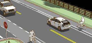
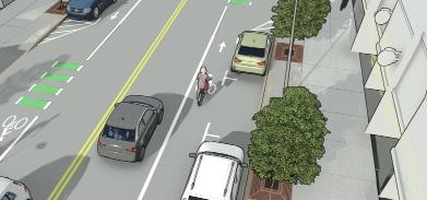
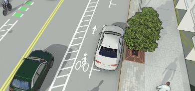
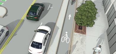
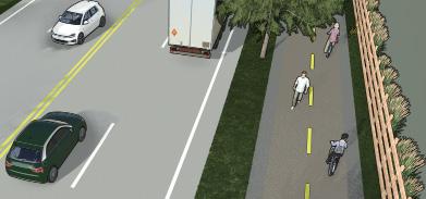
Shared Lane / Bike Boulevard
Low-speed, lowvolume neighborhood streets
Paved Shoulders
Rural or semi-rural roads without curbs
Bike Lane
Buffered Bike Lane
Urban/suburban streets with moderate traffic Roads with higher speeds or more vehicle traffic
Protected Bike Lane
Busy streets or areas with heavy traffic
Shared Use Path
Off-street corridors or parkways
Local travel where bikes and cars share the road safely
Biking along highways or regional routes with higher speeds Daily bike commuting and recreation on collector/arterial roads
Added comfort and space for people biking next to traffic
High-visibility, highcomfort routes for all ages and abilities
Multi-use travel and recreation by bikes, walkers, and others
How to Use the Toolbox
The guidelines incorporate national standards (e.g., NACTO, AASHTO, MUTCD) but are tailored to local conditions and needs. They serve as a decision-support tool for CYMPO member agencies to deliver context-sensitive bike infrastructure projects. Selecting a bikeway starts with understanding the surrounding environment. Choosing the right bike facility starts with understanding the street and who uses it. Key factors to consider include:
■ Traffic Speeds: Higher speeds call for more protection for people biking.
■ Traffic Volumes: The more cars on the road, the more separation bikes need.
■ Available Road Width: Determines what type of bikeway can fit.
■ Nearby Land Uses: Areas with schools, parks, or shops usually have more bike activity and may need highercomfort facilities.
This toolbox helps planners and engineers make informed, consistent, and community-supported decisions about bicycle infrastructure that work for all users.
Key Design Elements in the Guidelines:
The CYMPO Bicycle Design Guidelines provide practical, adaptable design tools to support the development of safe, connected, and comfortable bike networks across the region. The guidelines design treatments for:
■ Intersections: Including conflict zone markings, bicycle signals, and signage to improve visibility and reduce crashes.
■ Driveway Crossings: Strategies to maintain rider priority with high-visibility pavement treatments.
■ Transitions: Recommendations for smooth, intuitive connections between different facility types.
■ Accessibility: Emphasis on inclusive design to ensure facilities work for all ages and abilities.
■ Quick-Build Options: Guidance on using interim materials (e.g., striping, flexible posts, paint) to implement projects quickly while testing designs and building public support.
Strategic Opportunities for Implementation
During the development of ACT-UP, several projects emerged as strong case examples or “low-hanging fruit” opportunities to improve multimodal safety and accessibility. These projects were identified based on community input, data-driven needs, and their potential to serve as visible, early wins. To support local agency action, the study team developed concept-level designs for these locations. These concepts illustrate how targeted investments can enhance connectivity, safety, and comfort for people walking, biking, and using mobility devices—while aligning with broader regional goals.
Goodwin Street and Granite Street Bike Facilities
This intersection in Downtown Prescott, just north of Jefferson Park, currently features diagonal and parallel parking along Goodwin and Granite Streets. Both streets serve as bike routes and have sidewalks. The proposed improvements include converting diagonal parking on Goodwin Street to parallel parking to make space for buffered bike lanes. Green conflict striping through the intersection highlights bike crossings, while curb extensions reduce crossing distances and help calm turning traffic, enhancing safety for pedestrians and cyclists.
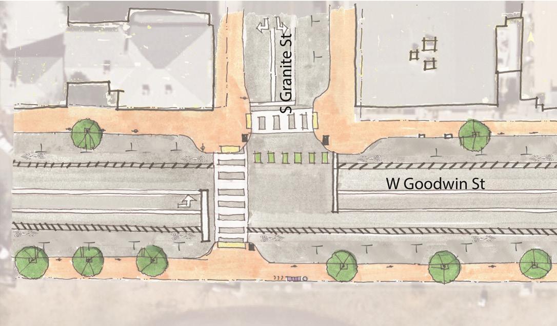
High Visibility Cross walks and ADA Crossing Pads
Parallel Parking with Buffered Bike Lane
Intersection Bulb Outs
Downtown Mobility Hub
Mobility Hub Access Improvements in Downtown Prescott focus on the area surrounding the former Wells Fargo site. While the nearby streets currently feature sidewalks and limited bike infrastructure, the proposal aims to enhance access with lower-stress bike facilities. Improvements include high-visibility crosswalks, curb extensions, and a decorative brick intersection to calm traffic and increase pedestrian safety. Portions of parking on Union Street will be repurposed for micromobility parking to support the new mobility hub.
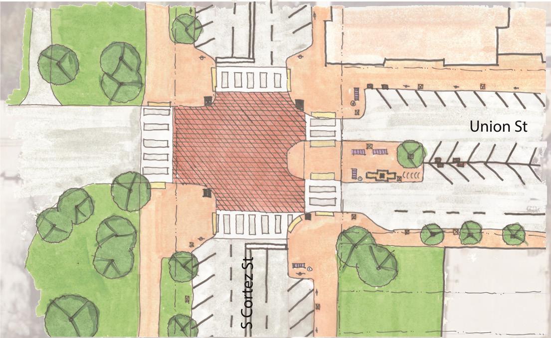
High Visibility Cross walks and ADA Crossing Pads
Pedestrian Amenities: Benches, Garbage Cans, Lighting
Intersection Bulb Outs with a Raised Intersection
Mobility Hub: Bike Share, Seating, EV Charging, Live Information
Gail Gardner Way
Gail Gardner Way is currently a two-lane road with no dedicated bicycle facilities. While some intersections have marked pedestrian crossings, the proposed improvements include 6.5-foot bike lanes with green conflict striping through intersections. Near the Iron Springs Road intersection, the bike lanes transition to shared lane markings (sharrows). Additional upgrades include new ADA-compliant curb ramps, landing areas, and striped crosswalks to enhance accessibility and safety for all users.
Potential Future Intersection Improvements (i.e., reduce turn lanes, include green bike lanes)
Maintain Existing Striping Approaching the Intersection
Transition Bike Lane into Shared Lane with Sharrows
New ADA Curb Ramps and Landing Area (TYP)
Stripe 6.5’ Bike Lanes (TYP)
Restripe Crosswalk
Stripe Crosswalk
Restripe 11’ Lanes (TYP)
Paint Conflict Striping (TYP)
Whetstine Avenue
This section of Whetstine Avenue provides access to Prescott High School but currently lacks sidewalks and bicycle facilities for students. The proposal introduces a 10-foot shared use path on the south side of the road, designed for both pedestrians and cyclists, with a 2-foot buffer separating it from the roadway. High-visibility crosswalks and ADA-compliant curb ramps are also included to improve safety and accessibility.
New 10’ Shared use path with Centerline Marking (TYP)
New ADA Curb Ramps and Landing Area (TYP)
New ADA Curb Ramp with 0.5’ curbs on each side (TYP)
New Shared use path Encroaches on School Right-of-Way
New Shared use path Ends, Merges into Existing 7’ Sidewalk
Rebuild Driveway (TYP)
Restripe 12’ Lanes (TYP)
New 2’ Buffer (TYP)
New Marked Crosswalk (TYP)
New School Crosswalk
New Advance Yield Shark Teeth Markings (TYP)
Prescott High School
North Road 1 East
This two-lane roadway currently lacks pedestrian and bicycle facilities. The proposed improvements include a 10-foot shared use path with a 4-foot buffer to separate users from vehicle traffic. High-visibility crosswalks and ADA-compliant ramps enhance safety, and the new path will connect seamlessly with existing sidewalks near the new development at Ashburn Way.
New Marked Crosswalk (TYP)
Restripe 11’ Lanes (TYP)
New 10’ Shared use path (TYP)
New 4’ Buffer (TYP)
New ADA Curb Ramp with 0.5’ curbs on each side (TYP)
New 0.5’ Curb and 1’ Gutter (TYP)
Rebuild Driveway (TYP)
Chino Valley Community Center
Rebuild Driveway (TYP)
Del Rio and Heritage Middle School
Currently, there are no walking or biking facilities serving the nearby schools. The proposal includes a new 6-foot sidewalk along the north side of W Rd 2 North, narrowing to 4 feet where utility poles create constraints. A high-visibility crosswalk with ADA ramps is planned at the intersection of N Rd 1 W and W Rd 2 N, connecting to an 8-foot shared use path that guides students north along N Rd 1 W, improving safe access to and from the schools.
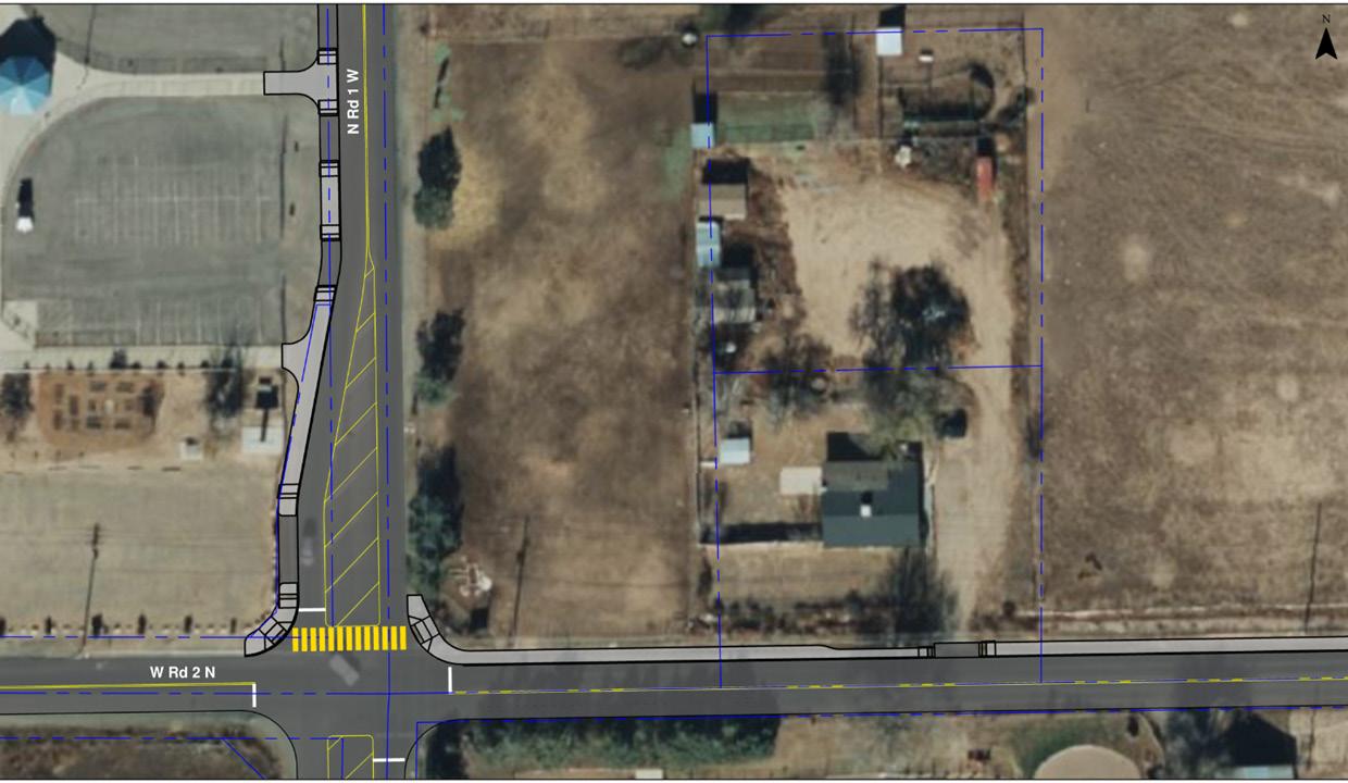
Extend New 8’ MUP to North Entrance of Heritage Middle School
New 8’ MUP to Tie in to Existing School Sidewalk
New ADA Curb Ramps and Landing Area (TYP)
New School Crosswalk
Restripe 12’ Lanes (TYP)
New 6’ Sidewalk
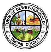
Main Street
This area currently has gaps in the sidewalk network and no bicycle facilities, creating challenges for safe travel. The proposal recommends filling sidewalk gaps. New 5-foot sidewalks with driveway separation are planned near SR 69, along with marked crosswalks at Huron and Prescott Streets. On-street parking in front of local businesses will be retained, while the new sidewalks enhance connectivity and safety for pedestrians.
Consider Traffic Calming Measures (i.e., chicanes, speed humps, transverse rumble strips)
Consider Traffic Calming Measures (i.e., chicanes, speed humps, transverse rumble strips)
12’ MUP with 4’ Buffer
New Sidewalk/ Driveway Separation
Restripe 12’ Lane (TYP)
New ADA Curb Ramps and Landing Area (TYP)
11’ On-Street Parking Zone
Existing 5’ Sidewalk
Existing 5’ Sidewalk
New 5’ Sidewalk
New 5’ Sidewalk with 2’ Buffer (TYP)
New 5’ Sidewalk with 2’ Buffer (TYP)
Existing Ramp and Landing Area
New Marked Crosswalk (TYP)
Willow Lake Road
This area currently has gaps in the sidewalk network and no bicycle facilities, creating challenges for safe travel. The proposal recommends filling sidewalk gaps. New 5-foot sidewalks with driveway separation are planned near SR 69, along with marked crosswalks at Huron and Prescott Streets. On-street parking in front of local businesses will be retained, while the new sidewalks enhance connectivity and safety for pedestrians.
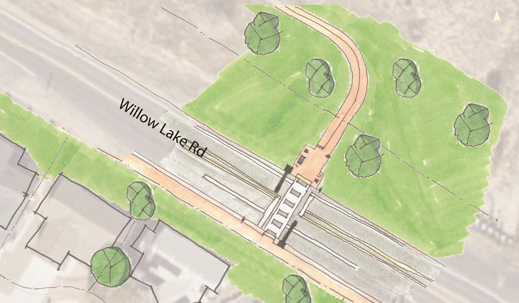
RRFB with High Visibility Cross walks and ADA Crossing Pads
RRFB with High Visibility Cross walks and ADA Crossing Pads
Improved Two Way Shared Use Path
Williamson Valley Road and Granite Oaks Drive
This vehicle-dominated intersection currently lacks safe access to the trailhead, with no bike or pedestrian facilities, putting non-motorized users at risk. The proposed improvements include added turn lanes on Williamson Valley Road to help drivers yield more safely to pedestrians and cyclists. High-visibility crosswalks and ADA-compliant ramps are also included to enhance accessibility and safety for all users.
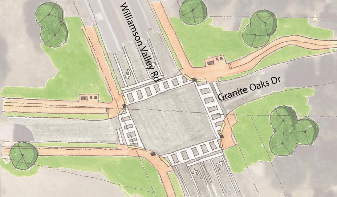
Pedestrian Amenities: Benches, Garbage Cans, Lighting
High Visibility Crosswalks and ADACrossing Pads
Two Way Shared Use Path
Funding Pathways
A variety of funding sources are available to support the development and maintenance of sidewalks, shared use paths, and on-street bicycle facilities across the CYMPO region. While many of these sources are competitive and require well-prepared applications, CYMPO and its member agencies can increase their chances of success through strategic partnerships, alignment with regional priorities, and early coordination with funding agencies.
Federal, State, and Local Funding
Programs such as the Surface Transportation Block Grant Program (STBGP) and Transportation Alternatives Program (TAP) provide flexible funding for bicycle and pedestrian projects. State programs, including the Arizona Department of Transportation (ADOT)’s Transportation Alternatives funds and local contributions through municipal Capital Improvement Programs (CIPs), can also support projects. Key Tip: Combining funding from multiple sources (e.g., federal + local match) and aligning with broader regional or state safety and mobility goals can significantly improve competitiveness.
Regional Opportunities
CYMPO coordinates regional transportation priorities and can help member agencies pursue funding through regional allocations, support letters, or joint applications. Collaboration across jurisdictions - especially for projects that cross boundaries or serve regional destinations- can strengthen proposals.
Road Safety Assessments (RSAs)
CYMPO and ADOT both support RSAs as a low-cost, high-value planning and design tool. These assessments identify safety issues and recommend solutions to reduce crash frequency and severity.
Developers
It is anticipated that as new residential and commercial developments arise, developers will build additional facilities that will expand and enhance the active transportation network including:
■ Constructing pedestrian and bicycle facilities to their property and, as applicable, provide connections to nearest facilities.
■ Ensuring pedestrian connectivity through the end of cul-de-sacs to shorten trip distances for walking and bicycling.
■ Installing shaded and secure bicycle parking facilities at residential, office, school, commercial, and recreational developments.
FUNDING OPPORTUNITY
Federal Transit Administration (FTA) Section 5310 & 5311
Surface Transportation Block Grant (STBG) Program
Transportation Alternatives Program (TAP)
Highway Safety Improvement Program (HSIP)
OVERVIEW
Funds available to support transit and non-motorized access for elderly individuals and persons with disabilities in rural areas. Eligible uses may include sidewalk or shared-use path connections to transit.
STBG funds can be used flexibly for pedestrian and bicycle infrastructure, including sidewalk infill, bike lanes, multiuse paths, and complete street improvements.
A major funding source for standalone active transportation projects. Funds can support trails, sidewalks, bike lanes, Safe Routes to School, and more.
HSIP supports data-driven safety projects. Non-motorized safety enhancements, including pedestrian crossings and protected bike lanes, may be eligible with supporting crash or safety data.
Recreational Trails Program (RTP)
Safe Routes to School (SRTS)
Local or Private Partnerships
RTP funds support the development and maintenance of trails for non-motorized use. These can include paved paths, trailheads, and signage. Administered at the state level by Arizona State Parks.
Supports infrastructure and non-infrastructure projects to improve safety and encourage walking and biking to school. ADOT administers federal SRTS funding and coordinates with local agencies.
Rebuilding American Infrastructure with Sustainability and Equity (RAISE) grants support multimodal projects with regional benefits, including trails, complete streets, and safe crossings. Highly competitive and requires strong benefit-cost analysis.
CYMPO member agencies may pursue partnerships with local developers, health organizations, or tourism entities to co-fund projects that improve walking, biking, and quality of life.
USDOT RAISE Grant
Policy and Program Considerations
To support the development of a safe, connected, and accessible active transportation network, the following outlines opportunities to strength strengthen local and regional guidance, align with state and federal best practices, and implement supportive programs that encourage walking, biking, and other forms of active travel. These considerations provide a foundation for long-term success by embedding active transportation into planning, funding, and decisionmaking processes.
OPPORTUNITY
Design Assistance Program
Online Active
Transportation Information and Maps
Safe Routes to School (SRTS)
Update Local Design Standards
Establish a Bicycle and Pedestrian Advisory Group (BPAG)
Regional Wayfinding and Signage
Quick-Build and Interim Projects
Regional
Bicycle & Pedestrian Count Program
OVERVIEW
CYMPO could establish a Design Assistance Program modeled after the successful program at the Maricopa Association of Governments (MAG). This program would provide local jurisdictions with technical support to advance active transportation projects - from concept development to preliminary design. By offering on-call consultant assistance, the program can help communities refine project scopes, improve grant readiness, and align designs with regional goals and best practices.
CYMPO could develop a regional active transportation webpage to serve as a central hub for walking and biking information. This site would provide maps of existing and recommended routes, updates on infrastructure projects, and resources on safe travel and bike maintenance. By offering accessible, user-friendly information - such as routes to schools and parks, bike parking locations, and a calendar of events -the platform would help reduce barriers for people interested in walking or biking but unsure where to start.
CYMPO and its member agencies can partner with school districts to develop and implement SRTS programs that make walking and biking to school safer and more appealing. These efforts can include infrastructure improvements, educational campaigns, and community events like bike rodeos, walk audits, and walking school buses. By working together, local agencies can support student health, safety, and active transportation through coordinated planning and engagement.
CYMPO and its member agencies can adopt and integrate national best practices outlined in the CYMPO ACT-UP Bicycle Facility Design Guidelines into local standards and manuals. Doing so will help ensure consistent, safe, and high-quality bicycle facility design across the region, supporting regional connectivity and project eligibility for state and federal funding.
CYMPO could formalize a BPAG composed of community members, advocates, and local agency staff to guide active transportation planning, review projects, and promote regional coordination. This group would ensure that local knowledge and user perspectives are integrated into planning and implementation efforts.
CYMPO can coordinate with member agencies to develop consistent wayfinding and signage standards for active transportation facilities. Clear, branded signage helps users navigate trails and bike routes, identify key destinations, and feel more confident while traveling. A regional approach to wayfinding enhances system legibility and promotes a cohesive user experience across jurisdictions.
CYMPO and member agencies can update street design standards to reflect a Complete Streets approach and incorporate the ACT-UP Bicycle Design Toolkit. This ensures that new and reconstructed roadways include safe, context-sensitive facilities for people walking and biking of all ages and abilities.
CYMPO can lead a regional effort to collect and maintain regular data on pedestrian and bicycle volumes across key corridors and destinations. This data will support evaluation, project prioritization, and funding applications.
CENTRAL YAVAPAI