Information Memorandum - 290 Nepean Highway, Seaford
As Melbourne’s leading independent commercial property agency, we take pride in creating worth across all four points of this city.
01. Point of Interest 02. Point of View
Property Features
Property Particulars 05. Location
06. Sales Process
07. Appendices Zoning and Overlays
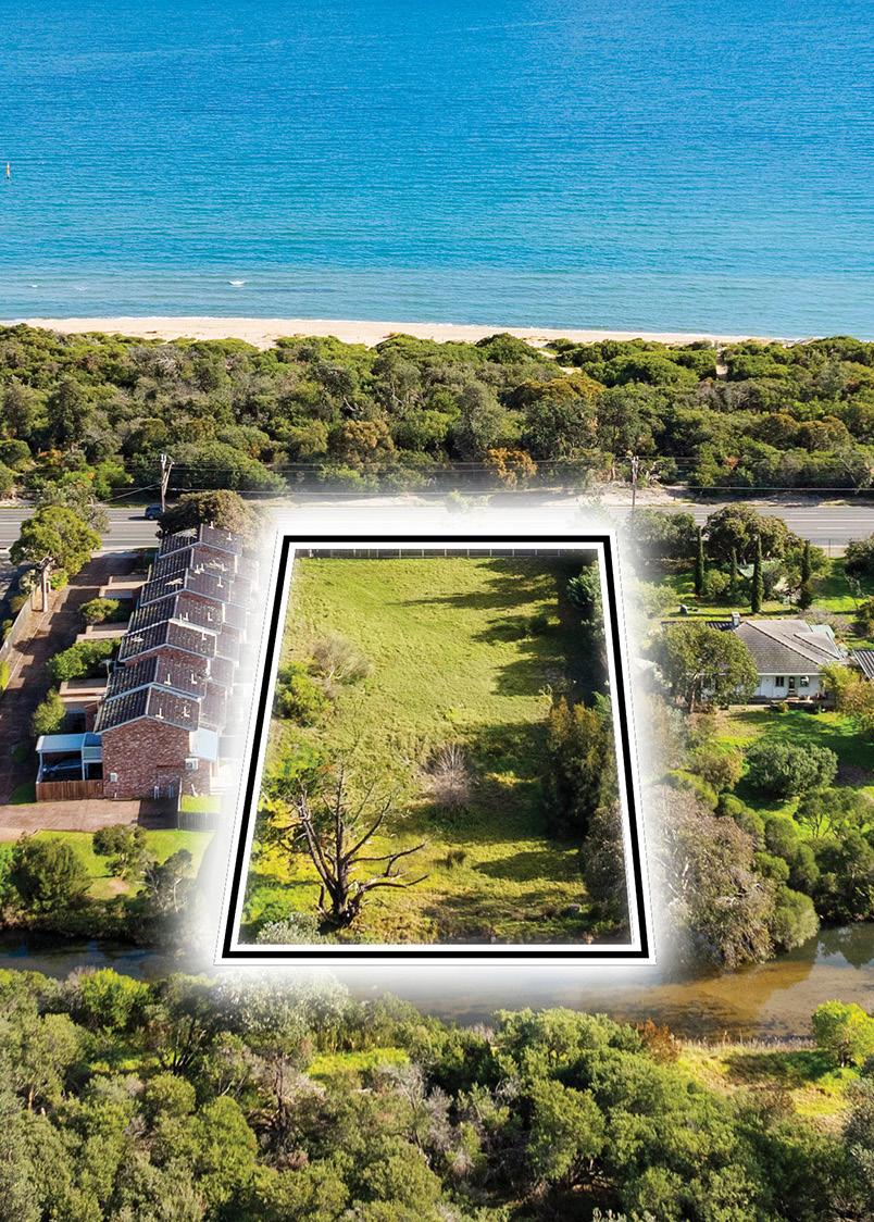
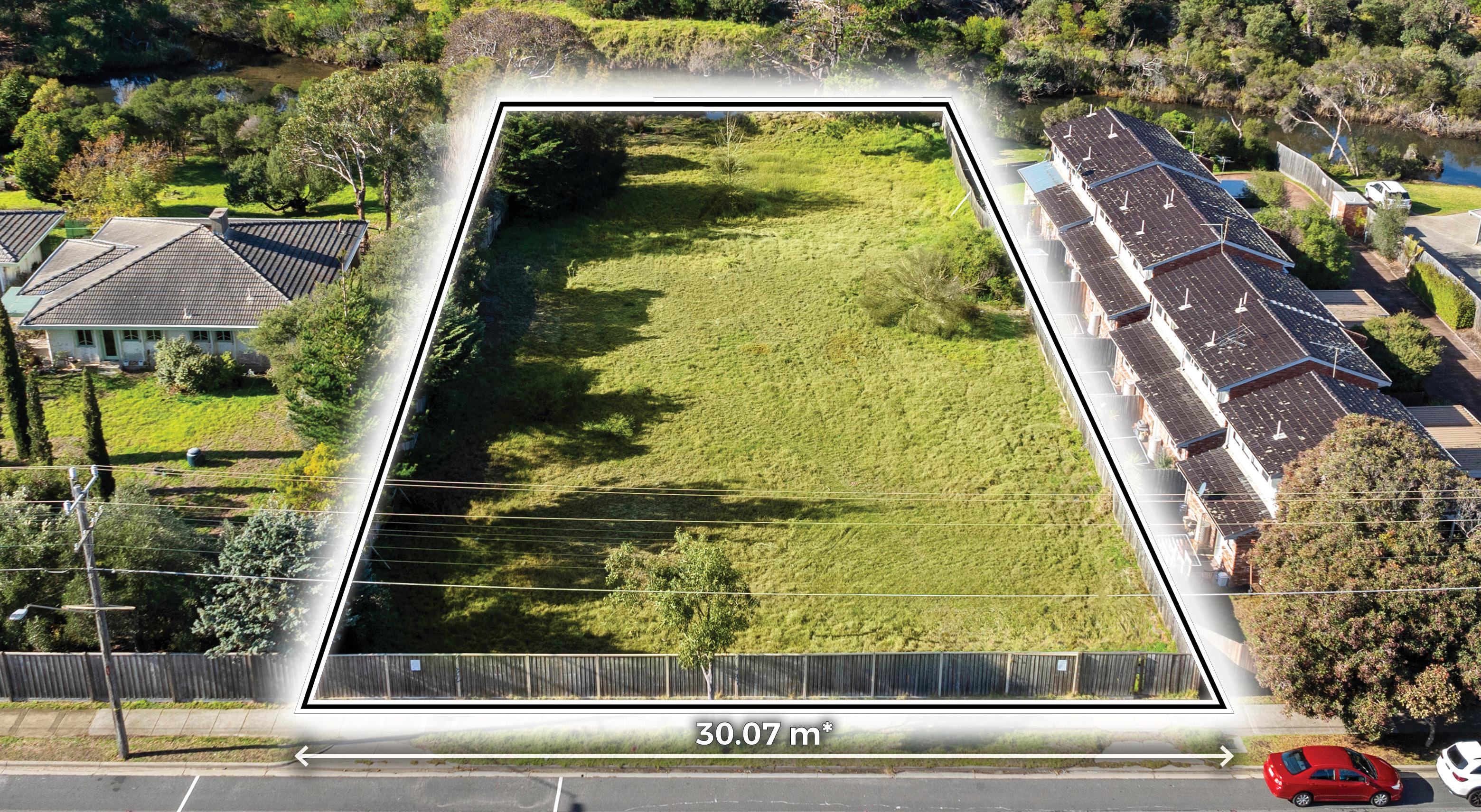
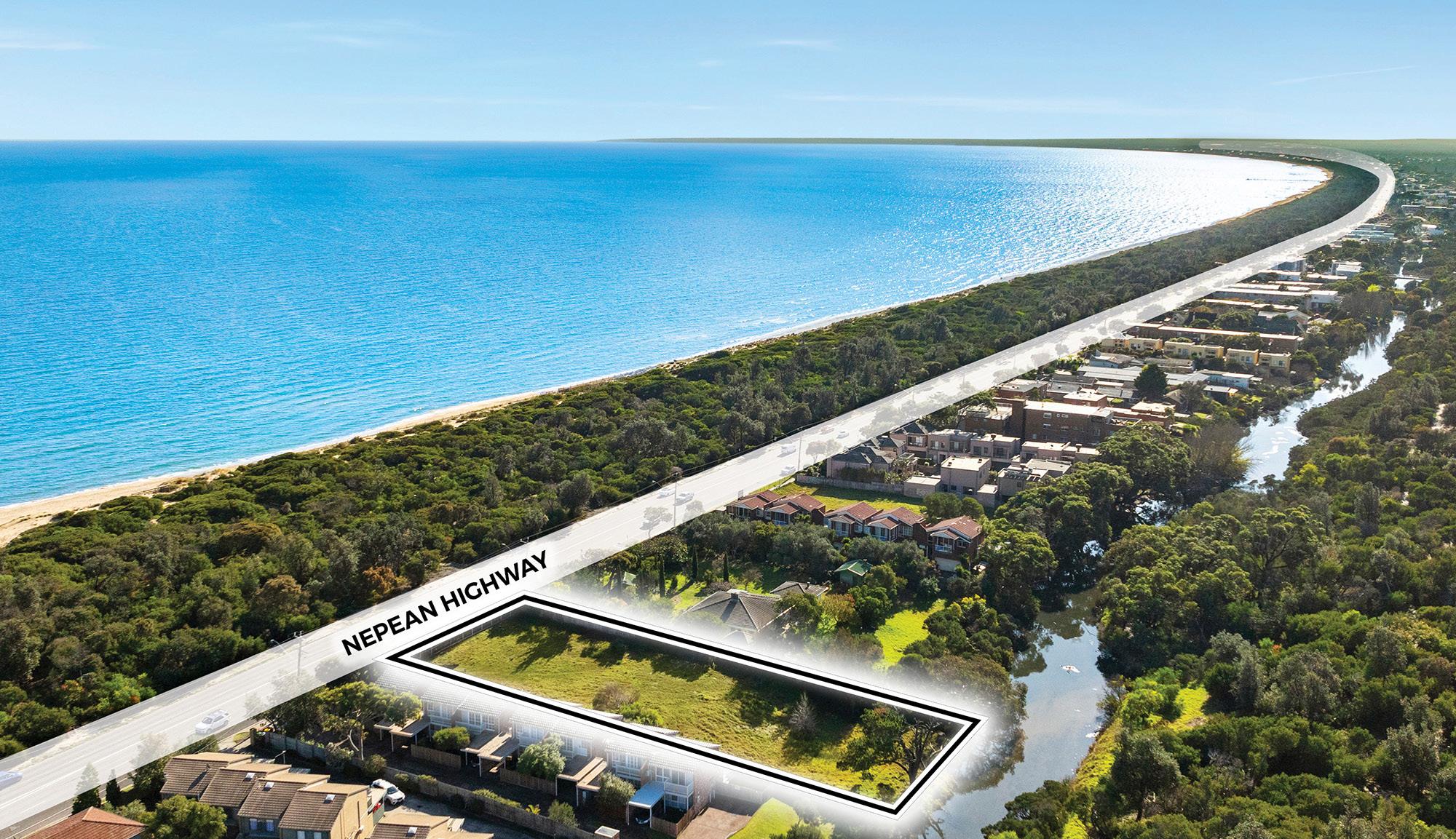
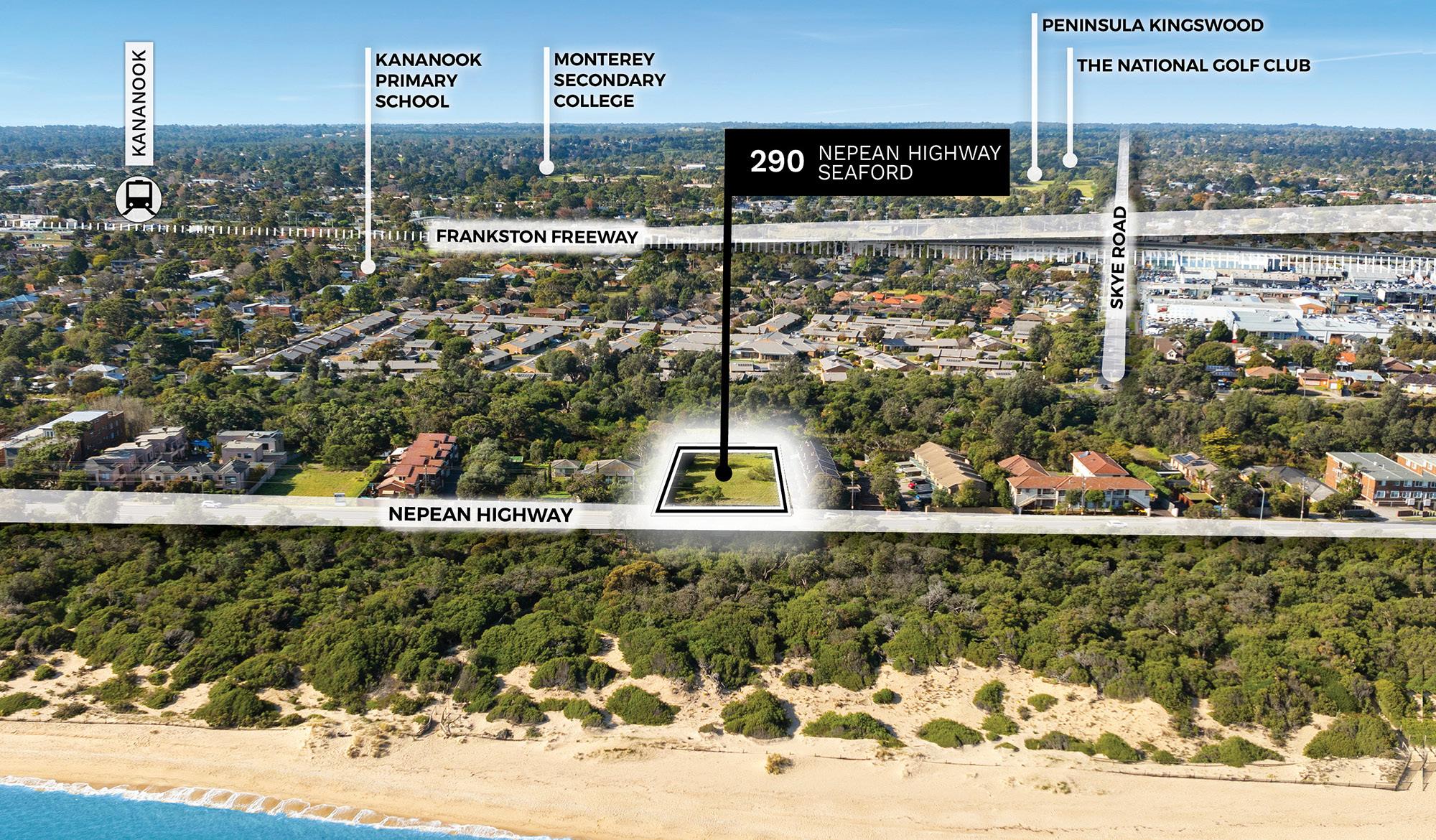
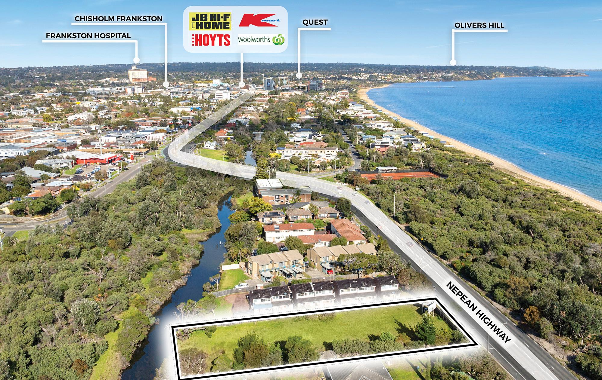
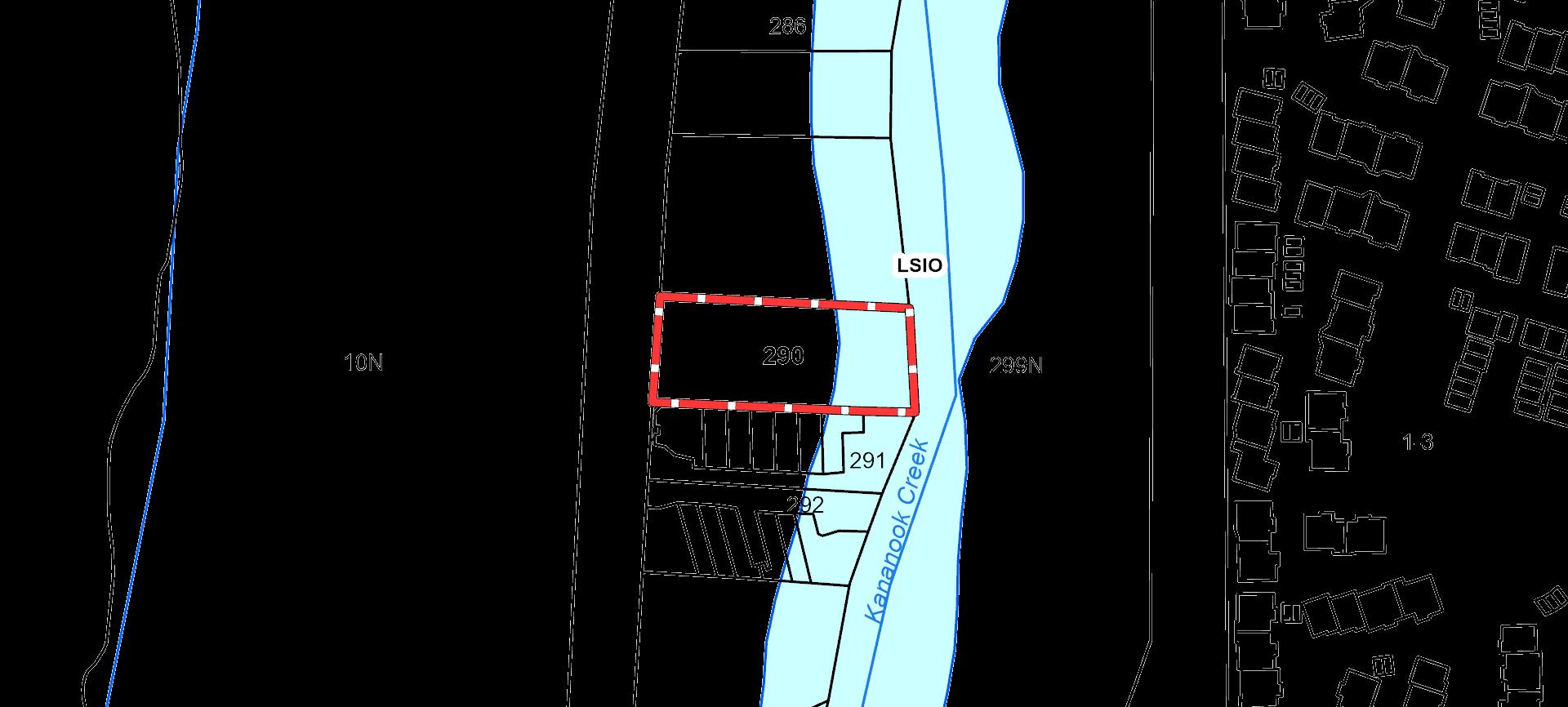
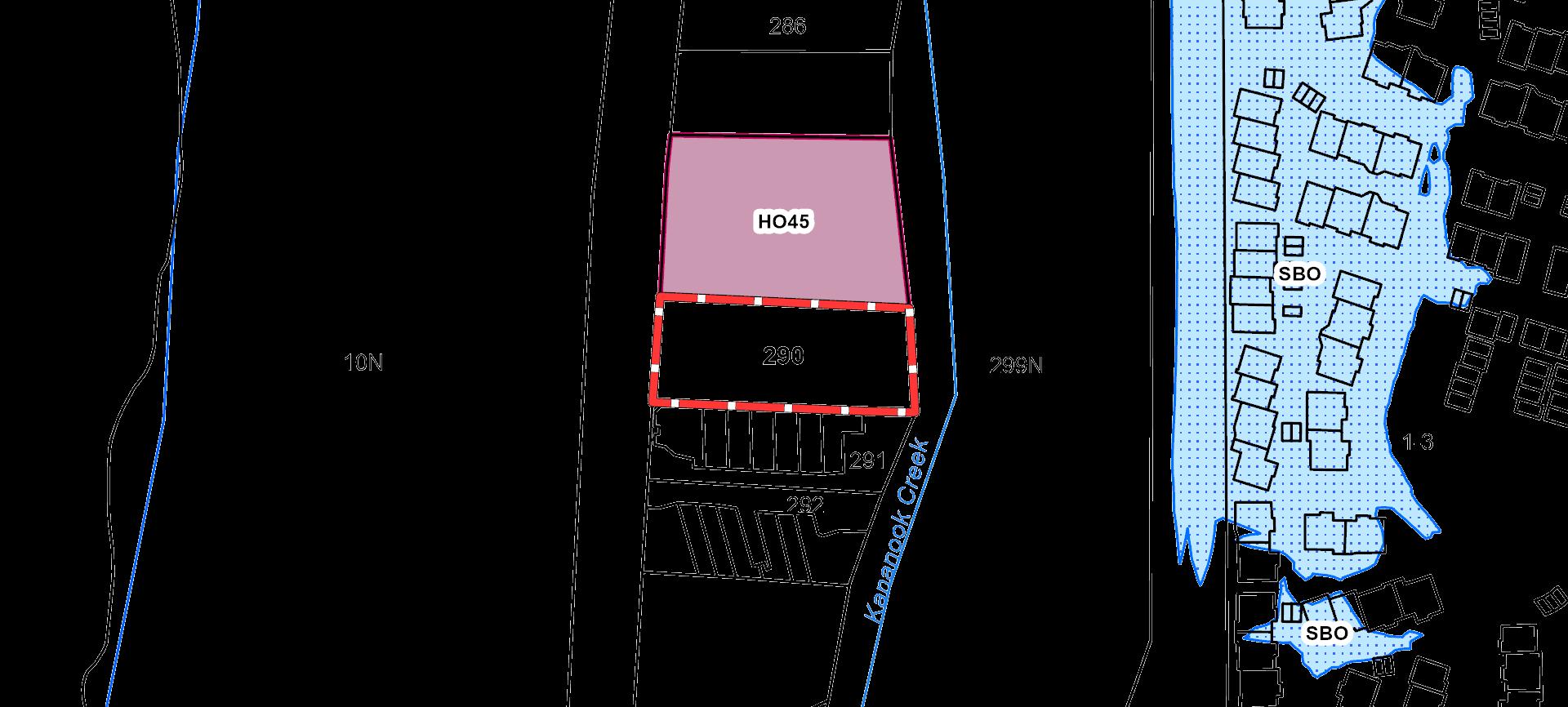
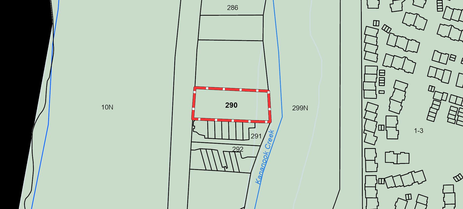
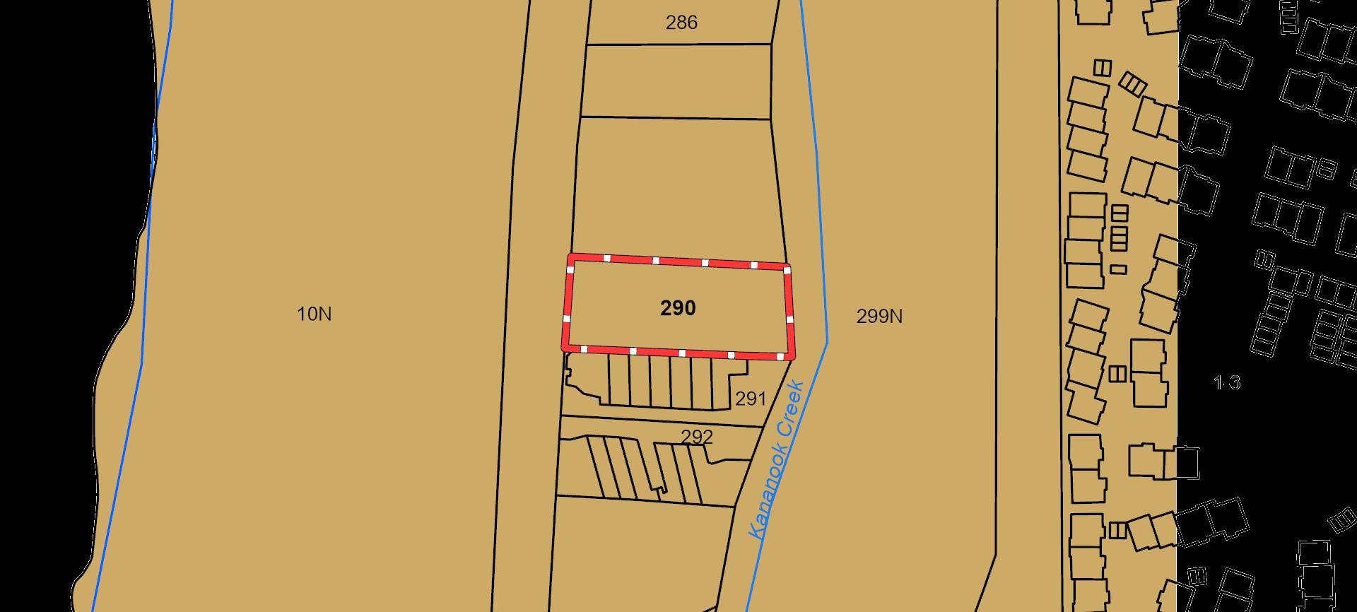
With 2,279 sqm* of land, 30.07 m* of Nepean Highway frontage, and General Residential Zoning (GRZ3) to unlock it all — this is a significant development site sitting squarely on the Nepean with the beach quite literally on your doorstep. Directly opposite Long Island Beach and moments from Frankston’s Activity Centre, 290 Nepean Highway is a prime coastal canvas ready for townhouses, apartments, childcare, or a mix of them all.
The burgeoning Seaford location pairs lifestyle with logistics — walk to Bayside Shopping Centre, Kananook Railway Station, schools, parks and of course, the beach boardwalk. With vacant possession and no demolition required, this is a clean slate in every sense, perfectly positioned for developers who want to break ground, not the bank.
To Kananook Railway Station
To Bayside Shopping Centre
General Residential
to Frankston Hospital
To the Frankston Freeway
With direct beach access, abundant surrounding amenities, and a generous footprint to work with, this is coastal development potential in its purest form — ready to make waves.
Daniel Philip | 0439 977 121 daniel.philip@cva.melbourne
“This isn’t just land, it’s lifestyle on a lot title— straight across from the shore and set for something sensational.”
An agent that turns first impressions into lasting commitments. Since the early days of his career, Daniel has established a level of service that is defined by in-depth market knowledge, expert advice and responsive communication. Committed to creating value in the commercial real estate opportunities he matches with his clients’ objectives, and the ability to think outside the square. Especially if that extends well beyond Melbourne’s inner-city grid.
Tim Cooney | 0468 860 737 tim.cooney@cva.melbourne
“When the surf’s this close, your development is already ahead of the curve—unlock beachfront brilliance with every square metre.”
After five years spent working in commercial real estate in London, Tim is home in 2021. Melbourne born and bred with more than 5 years’ experience locally, there aren’t many who are better suited to this business. Diligent. Proactive. An honest communicator. Tim knows it’s in the face-toface where deals are won and lost for all parties. Because of this, he takes great care in building rapport and learning the long-term strategy of his clients to enable the best advice not just shortterm, but for life. Meticulously detailed and across all of the numbers, you’ll be glad you have Tim’s on hand – plus his support across all points of your deal.
“290 Nepean Highway presents an unrivalled opportunity for developers seeking a premium slice of a beachside town. Set on a generous 2,279 sqm* allotment with 30.07 metres* of prime highway frontage, this vacant, clean-titled land sits just footsteps from the beach — a rarity in today’s tightly held coastal market. Zoned GRZ3, the site supports medium-density residential development such as townhouses or apartments, or even a childcare facility — all in a location that effortlessly blends lifestyle and accessibility. With no demolition or cleanup required, it’s ready for immediate action and tailored vision.
The surrounding growth is undeniable. With direct beach access and walkable connections to Kananook Railway Station, Bayside Shopping Centre, Frankston Hospital, and key retail hubs like Kmart, Hoyts, and Woolworths, the area is primed for further improvement. The combination of high visibility, strong residential demand, and proximity to both nature and infrastructure makes this site a strategic and futureproof investment. As Frankston and Seaford continue to evolve into lifestyle-centric urban hubs, 290 Nepean Highway positions itself as a cornerstone of smart coastal development — where business potential meets bayside beauty.
Principle Outgoings
Site
Title particulars
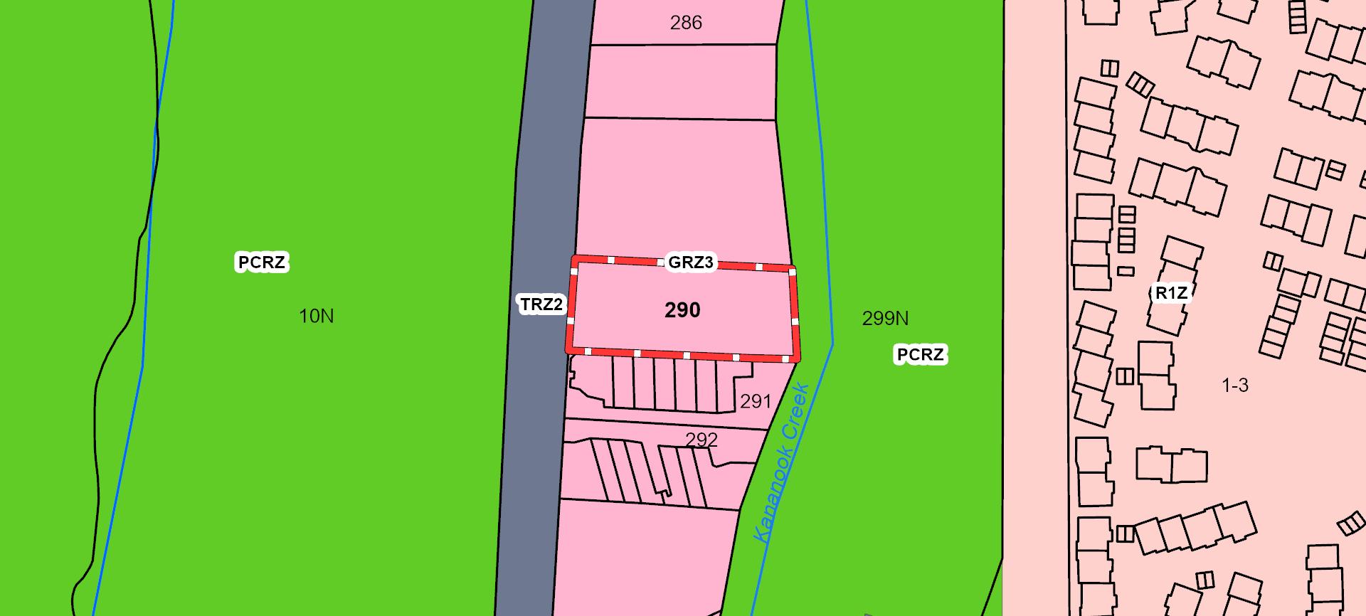
Certificate of Title — Volume 04198 Folio 537 Lot 1 on Title Plan 404114V
Zoning General Residential Zone (GRZ3)
Planning Overlays
Municipality
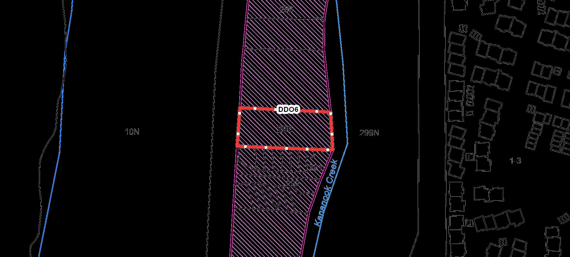
Design And Development Overlay (DDO6)
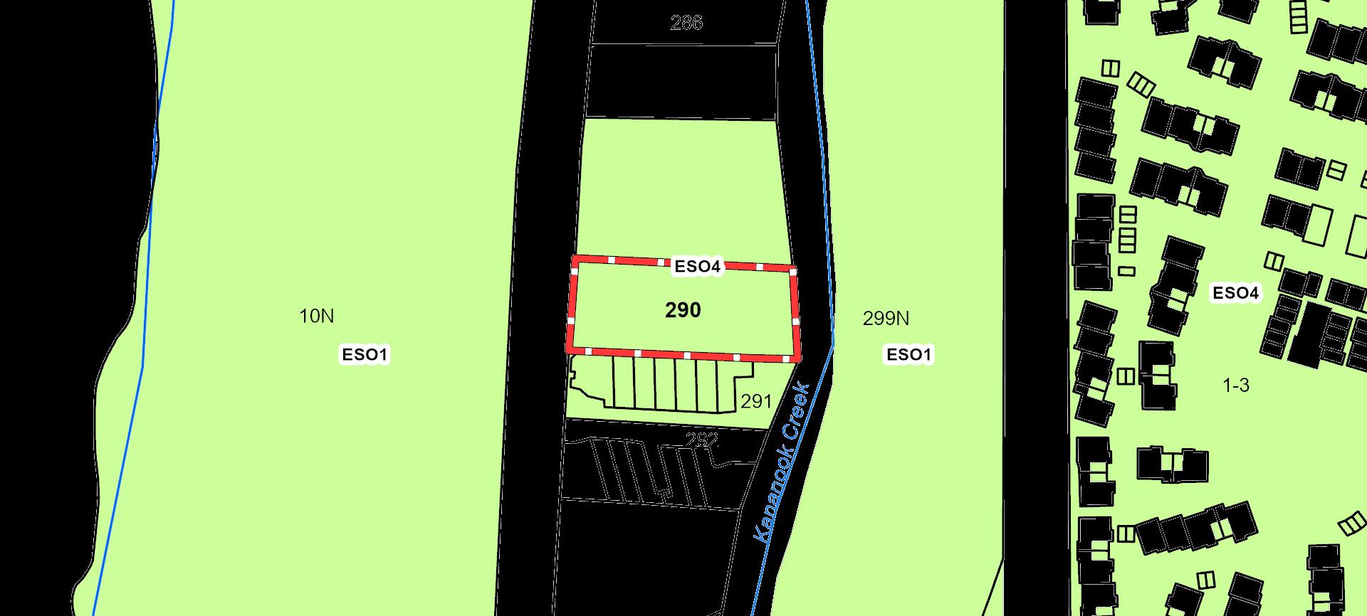
Environmental Significance Overlay (ESO4) Land Subject To Inundation Overlay (LSIO)
City of Frankston
All signs point to: Nepean Highway
Positioned along one of Melbourne’s most prominent coastal corridors, Nepean Highway offers the perfect blend of high exposure, lifestyle appeal, and commercial potential — making it a prime destination for forward-thinking businesses and developers alike.:
High Exposure and Traffic Flow:
Nepean Highway is one of Melbourne’s busiest arterial roads, providing businesses with maximum visibility and exposure to thousands of daily commuters, tourists, and local traffic.
Proximity to Key Amenities:
The highway runs through major commercial precincts with easy access to shopping centres, healthcare (Frankston Hospital), schools, and recreational hotspots — creating a strong customer base for a variety of business types.
Coastal Appeal:
Its closeness to beaches like Long Island Beach and Olivers Hill enhances the lifestyle factor, attracting both residents and tourists year-round — perfect for retail, hospitality, or wellness ventures.
Strong Residential Growth:
The surrounding suburbs including Frankston and Seaford are experiencing rapid development, increasing the local population and demand for services, housing, and retail offerings.
Connectivity and Transport Links:
Located near major transport options such as the Frankston Freeway, Kananook Railway Station, and bus routes, the area offers seamless connectivity for staff, customers, and logistics — a big plus for any business looking for accessibility.
AND THE POINT?
The Shoreline: Exposed. Energised. Evolving.
Securing a foothold on Nepean Highway, Seaford places you at the heart of Melbourne’s premier bayside corridor—where nonstop traffic meets laid-back coastal charm, and public-sector investment is unlocking the next wave of residential and commercial demand. For visionary operators and developers, this is the address where visibility, lifestyle magnetism and long-term growth converge.
All signs point to: Seaford
Seaford offers that rare mix of “coastal cool” and commuter convenience that businesses crave. Sitting on the Nepean Highway spine—now free of the Seaford Road rail crossing and stitched together with 6 km of new shared paths—customers can arrive by car, train or bike with ease, then spill straight onto the foreshore boardwalk or Kananook Creek trail for a post-purchase stroll. The suburb’s $10 million revitalisation program is greening verges, widening footpaths and adding pocket parks, drawing a steady stream of residents, beach-goers and day-trippers past shopfronts and cafés every day of the week.
Strong public-sector backing is turning that pedestrian energy into economic momentum. A fresh $50 million federal injection for the Nepean Boulevard masterplan, council activation grants for the Seaford shopping strip, and the newly adopted Industrial Strategy that upgrades
Hartnett Boulevard all spell long-term confidence for operators who set up now. Private developers are following suit: three-storey apartments at 12 Nepean Hwy, boutique townhouses at 105 Austin Rd and 196 Nepean Hwy, plus larger mixed-use proposals up and down the strip, will add hundreds of new residents by 2026— expanding the local customer base without businesses having to chase it. With cash, planning reform and population growth all converging, Seaford is primed for enterprises that want a bay-side address and a balance sheet that keeps rising with the tide.
Private Sale Process
At CVA, we are dedicated to providing a professional and transparent experience throughout the private sale process.
To ensure clarity and fairness, we have outlined the key steps below, allowing prospective purchasers to fully understand the process when submitting an offer.
1. Submitting Offers
Offers can be submitted at any point during the private sale period, as there is no fixed closing date. We recommend that all interested parties submit their strongest offer using the provided documentation, ensuring all fields are completed and the form is signed. Once submitted, your offer will be promptly presented to the vendor for consideration.
2. Review Process
Upon receipt, all offers are carefully reviewed by the vendor. We will communicate any feedback or decisions regarding your offer in a timely manner. Unlike auctions or formal Expressions of Interest campaigns, the private sale allows the vendor the flexibility to accept, negotiate, or decline offers at their discretion as they are received.
3. Contract and Settlement
Should your offer be accepted, a formal contract of sale will be prepared. At this stage, a deposit may be required to secure the property. The agreed terms of the contract, including the settlement period, will then be finalised between the buyer and vendor.
We strive to maintain open communication and provide professional guidance throughout the private sale process, ensuring a seamless experience for all parties involved.
For more information, contact
Daniel Philip
0439 977 121
daniel.philip@ cva.melbourne
Tim Cooney 0468 860 737
tim.cooney@ cva.melbourne
Addres s :
t and Pl an Number:
tandard Parcel I dentifier ( S PI ) :
ZONING AND OVERLAYS
PL A N N IN G PROPERTY
ZONING AND OVERLAYS
PL A N N IN G PROPERTY REPORT
ZONING AND OVERLAYS
PL A N N IN G PROPERTY REPORT
F u r t h er Plan n in g In fo r mat io n
Pl anning s cheme data l as t updated o n 3 J ul y 2 02 5
A plan n in g s ch eme s ets o ut po l icies and requirements fo r the us e, devel o pment and pro tectio n o f l and This repo rt pro vides info rmatio n abo ut the zo ne and o verl ay pro vis io ns that appl y to the s el ected l and
I nfo rmatio n abo ut the S tate and l o cal po l icy, particul ar, general and o peratio nal pro vis io ns o f the l o cal pl anning s c heme that may affect the us e o f this l and can be o btained by co ntacting the l o cal co uncil o r by vis iting https :/ / www pl anning vic go v au
This repo rt is NOT a Plan n in g Cer t ificat e is s ued purs uant to S ectio n 19 9 o f the Plan n in g an d En v iro n men t A ct 19 87 . I t do es no t incl ude info rmatio n abo ut exhibited pl anning s cheme amendments , o r zo nings that may abut the l and To o btain a Pl anning Certificate go to Titl es and Pro perty Certificates at Landata - https :/ / www l andata vic go v au
Fo r detail s o f s urro unding pro perties , us e this s ervice to get the Repo rts fo r pro perties o f interes t
To view pl anning zo nes , o verl ay and heritage info rmatio n in an interactive fo rmat vis it https :/ / maps hare maps vic go v au/ vicpl an
Fo r o ther info rmatio n abo ut pl anning in Victo ria vis it https :/ / www pl anning vic go v au
ZONING AND OVERLAYS
PL A N N IN G PROPERTY REPORT
C r ea te a BP A defin itio n pla n in VicP la n to m ea s u r e th e BP A
In fo r m a tio n fo r lo t o wn er s bu ildin g in th e BP A is a va ila ble a t h ttps : //www pla n n in g vic g o v a u
Fu r th er in fo r m a tio n a bo u t th e bu ildin g co n tr o l s ys tem a n d bu ildin g in bu s h fir e pr
Victo r ia n Bu ildin g Au th o r ity webs ite h ttps : //www vba vic g o v a u C o pies o f th e Bu
Nat iv e Veget at io n
Native pl ants that are indigeno us to the regio n and impo rtant fo r bio divers ity might be pres ent o n this pro perty This co ul d incl ude trees , s hrubs , herbs , gras s es o r aquatic pl ants There are a range o f regul atio ns that may appl y incl uding need to o btain a pl anning permit under Cl aus e 52 17 o f the l o cal pl anning s cheme Fo r mo re info rmatio n s ee Native Vegetatio n ( Cl aus e 52 17) with l o cal variatio ns in Native Vegetatio n ( Cl aus e 52 17) S chedul e
To hel p identify native vegetatio n o n this pro perty and the appl icatio n o f Cl aus e 52 17 pl eas e vis it the Native Vegetatio n I nfo rmatio n Management s ys tem https :/ / nvim del wp vic go v au/ and Native vegetatio n ( enviro nment vic go v au) o r pl eas e co ntact yo ur rel evant co uncil
Yo u can find o ut mo re abo ut the natural val ues o n yo ur pro perty thro ugh NatureKit NatureKit ( enviro nment vic go v au) 0 65 m
32.08
31/03/2025
VC267
32 08-1
27/03/2017 VC110
32.08-2
14/01/2025 VC237
FRANKSTON PLANNING SCHEME
GENERAL RESIDENTIAL ZONE
Shown on the planning scheme map as GRZ , R1Z , R2Z or R3Z with a number (if shown)
Purpose
To implement the Municipal Planning Strategy and the Planning Policy Framework
To encourage development that is responsive to the neighbourhood character of the area
To encourage a diversity of housing types and housing growth particularly in locations offering good access to services and transport
To allow educational, recreational, religious, community and a limited range of other nonresidential uses to serve local community needs in appropriate locations.
Neighbourhood character objectives
A schedule to this zone may contain neighbourhood character objectives to be achieved for the area
Table of uses
Section 1 - Permit not required
Use
Automated collection point
Bed and breakfast
Community care accommodation
Domestic animal husbandry (other than Domestic animal boarding)
Dwelling (other than Bed and breakfast)
Home based business
Informal outdoor recreation
Medical centre
Condition
Must meet the requirements of Clause 52.13-3 and 52.13-5.
The gross floor area of all buildings must not exceed 50 square metres.
No more than 10 persons may be accommodated away from their normal place of residence.
At least 1 car parking space must be provided for each 2 persons able to be accommodated away from their normal place of residence.
Must meet the requirements of Clause 52.22-2.
Must be no more than 2 animals.
The gross floor area of all buildings must not exceed 250 square metres.
Must not require a permit under Clause 52.06-3.
The site must adjoin, or have access to, a road in a Transport Zone 2 or a Transport Zone 3.
Use
Place of worship
Racing dog husbandry
Railway
Residential aged care facility
Rooming house
Small second dwelling
Condition
The gross floor area of all buildings must not exceed 250 square metres.
The site must adjoin, or have access to, a road in a Transport Zone 2 or a Transport Zone 3.
Must be no more than 2 animals.
Tramway
Any use listed in Clause 62.01
Section 2 - Permit required
Must meet the requirements of Clause 52.23-2.
Must be no more than one dwelling existing on the lot.
Must be the only small second dwelling on the lot.
Reticulated natural gas must not be supplied to the building, or part of a building, used for the small second dwelling.
Must meet the requirements of Clause 62.01.
Accommodation (other than Community care accommodation, Dwelling, Residential aged care facility, Rooming house and Small second dwelling)
Agriculture (other than Animal production, Animal training, Apiculture, Domestic animal husbandry, Horse husbandry and Racing dog husbandry)
Car park
Car wash
Convenience restaurant
Convenience shop
Domestic animal husbandry (other than Domestic animal boarding) – if the Section 1 condition is not met
Must be used in conjunction with another use in Section 1 or 2.
The site must adjoin, or have access to, a road in a Transport Zone 2 or a Transport Zone 3.
The site must adjoin, or have access to, a road in a Transport Zone 2 or a Transport Zone 3.
Must be no more than 5 animals.
2 of 13
FRANKSTON PLANNING SCHEME
FRANKSTON PLANNING SCHEME
Use
Food and drink premises (other than Convenience restaurant and Take away food premises)
Grazing animal production
Leisure and recreation (other than Informal outdoor recreation and Motor racing track)
Market
Office (other than Medical centre)
Condition
The use must be associated with a use or development to which clause 53.23 (Significant residential development with affordable housing) applies.
Place of assembly (other than Amusement parlour, Carnival, Cinema based entertainment facility, Circus, Nightclub and Place of worship)
Plant nursery
Retail premises (other than Convenience shop, Food and drink premises, Market and Plant nursery)
Service station
Store
Take away food premises
Utility installation (other than Minor utility installation and Telecommunications facility)
Any other use not in Section 1 or 3
The use must be associated with a use or development to which clause 53.23 (Significant residential development with affordable housing) applies.
The site must either:
Adjoin a commercial zone or industrial zone.
Adjoin, or have access to, a road in a Transport Zone 2 or a Transport Zone 3.
The site must not exceed either:
3000 square metres.
3600 square metres if it adjoins on two boundaries a road in a Transport Zone 2 or a Transport Zone 3.
Must be in a building, not a dwelling, and used to store equipment, goods, or motor vehicles used in conjunction with the occupation of a resident of a dwelling on the lot.
The site must adjoin, or have access to, a road in a Transport Zone 2 or a Transport Zone 3.
32.08-3 14/12/2023 VC253
FRANKSTON PLANNING SCHEME
Section 3 – Prohibited
Use
Amusement parlour
Animal production (other than Grazing animal production)
Animal training
Cinema based entertainment facility
Domestic animal boarding
Extractive industry
Horse husbandry
Industry (other than Automated collection point and Car wash)
Motor racing track
Nightclub
Saleyard
Small second dwelling – if the Section 1 condition is not met
Transport terminal
Warehouse (other than Store)
Subdivision
Permit requirement
A permit is required to subdivide land
An application to subdivide land that would create a vacant lot less than 400 square metres capable of development for a dwelling or residential building, must ensure that each vacant lot created less than 400 square metres contains at least 25 percent as garden area. This does not apply to a lot created by an application to subdivide land where that lot is created in accordance with:
An approved precinct structure plan or an equivalent strategic plan;
An incorporated plan or approved development plan; or
A permit for development.
An application to subdivide land, other than an application to subdivide land into lots each containing an existing dwelling or car parking space, must meet the requirements of Clause 56 and:
Must meet all of the objectives included in the clauses specified in the following table
FRANKSTON PLANNING SCHEME
Should meet all of the standards included in the clauses specified in the following table.
Class of subdivision
60 or more lots
16 – 59 lots
3 – 15 lots
2 lots
Objectives and standards to be met
All except Clause 56.03-5.
All except Clauses 56.03-1 to 56.03-3, 56.03-5, 56.06-1 and 56.06-3.
All except Clauses 56.02-1, 56.03-1 to 56.03-4, 56.05-2, 56.06-1, 56.06-3 and 56.06-6.
Clauses 56.03-5, 56.04-2, 56.04-3, 56.04-5, 56.06-8 to 56.09-2.
A permit must not be granted which would allow a separate lot to be created for land containing a small second dwelling
VicSmart applications
Subject to Clause 71 06, an application under this clause for a development specified in Column 1 is a class of VicSmart application and must be assessed against the provision specified in Column 2
Class of application
Subdivide land to realign the common boundary between 2 lots where:
The area of either lot is reduced by less than 15 percent.
The general direction of the common boundary does not change.
Subdivide land into lots each containing an existing building or car parking space where:
The buildings or car parking spaces have been constructed in accordance with the provisions of this scheme or a permit issued under this scheme.
An occupancy permit or a certificate of final inspection has been issued under the Building Regulations in relation to the buildings within 5 years prior to the application for a permit for subdivision.
Subdivide land into 2 lots if:
The construction of a building or the construction or carrying out of works on the land:
– Has been approved under this scheme or by a permit issued under this scheme and the permit has not expired.
– Has started lawfully
The subdivision does not create a vacant lot.
Information requirements and decision guidelines
Clause 59.01
Clause 59.02
Clause 59.02
ZONING AND OVERLAYS
32 08-4
14/12/2023
FRANKSTON PLANNING SCHEME
Construction or extension of a dwelling, small second dwelling or residential building
Minimum garden area requirement
An application to construct or extend a dwelling, small second dwelling or residential building on a lot must provide a minimum garden area as set out in the following table:
32 08-5
This does not apply to:
An application to construct or extend a dwelling, small second dwelling or residential building if specified in a schedule to this zone as exempt from the minimum garden area requirement;
An application to construct or extend a dwelling, small second dwelling or residential building on a lot if:
– The lot is designated as a medium density housing site in an approved precinct structure plan or an approved equivalent strategic plan;
– The lot is designated as a medium density housing site in an incorporated plan or approved development plan; or
An application to alter or extend an existing building that did not comply with the minimum garden area requirement of Clause 32 08-4 on the approval date of Amendment VC110
Construction and extension of one dwelling on a lot
Permit requirement
A permit is required to construct or extend one dwelling on a lot less than 300 square metres
A permit is required to construct or extend a front fence within 3 metres of a street if the fence is associated with one dwelling on a lot less than 300 square metres and the fence exceeds the maximum height specified in Clause 54 06-2
A development must meet the requirements of Clause 54.
No permit required
No permit is required to:
Construct or carry out works normal to a dwelling
Construct or extend an out-building (other than a garage or carport) on a lot provided the gross floor area of the out-building does not exceed 10 square metres and the maximum building height is not more than 3 metres above ground level
Make structural changes to a dwelling provided the size of the dwelling is not increased or the number of dwellings is not increased.
32 08-6 14/12/2023
VicSmart applications
FRANKSTON PLANNING SCHEME
Subject to Clause 71 06, an application under this clause for a development specified in Column 1 is a class of VicSmart application and must be assessed against the provision specified in Column 2
Class of application
Construct or extend a dwelling on a lot less than 300 square metres if the development meets the requirements in the following standards of Clause 54:
A3 Street setback.
A10 Side and rear setbacks.
A11 Walls on boundaries.
A12 Daylight to existing windows.
A13 North-facing windows.
A14 Overshadowing open space.
A15 Overlooking.
For the purposes of this class of VicSmart application, the Clause 54 standards specified above are mandatory
If a schedule to the zone specifies a requirement of a standard different from a requirement set out in the Clause 54 standard, the requirement in the schedule to the zone applies and must be met.
Construct or extend a front fence within 3 metres of a street if the fence is associated with one dwelling on a lot less than 300 square metres.
Information requirements and decision guidelines
Clause 59.14
Clause 59.03
Construction and extension of a small second dwelling on a lot
Permit requirement
A permit is required to construct or extend a small second dwelling on a lot of less than 300 square metres.
A development must meet the requirements of Clause 54
VicSmart applications
Subject to Clause 71.06, an application under this clause for a development specified in Column 1 is a class of VicSmart application and must be assessed against the provision specified in Column 2
Class of application
Construct or extend a small second dwelling on a lot less than 300 square metres if the development meets the requirements in the following standards of Clause 54:
A3 Street setback.
A9 Building setback.
A9.1 Safety and accessibility
A10 Side and rear setbacks.
Information requirements and decision guidelines
Clause 59.14
Class of application
A11 Walls on boundaries.
A12 Daylight to existing windows.
A13 North-facing windows.
A14 Overshadowing open space.
A15 Overlooking.
For the purposes of this class of VicSmart application, the Clause 54 standards specified above are mandatory
If a schedule to the zone specifies a requirement of a standard different from a requirement set out in the Clause 54 standard, the requirement in the schedule to the zone applies and must be met.
32 08-7
Information requirements and decision guidelines
Construction and extension of two or more dwellings on a lot, dwellings on common property and residential buildings
Permit requirement
A permit is required to:
Construct a dwelling if there is at least one dwelling existing on the lot
Construct two or more dwellings on a lot
Extend a dwelling if there are two or more dwellings on the lot
Construct or extend a dwelling if it is on common property.
Construct or extend a residential building
A permit is required to construct or extend a front fence within 3 metres of a street if:
The fence is associated with 2 or more dwellings on a lot or a residential building, and
The fence exceeds the maximum height specified in Clause 55 02-8
A development must meet the requirements of Clause 55 This does not apply to a development of four or more storeys, excluding a basement.
A development of four storeys, excluding a basement, must meet the requirements of Clause 57
An apartment development of five or more storeys, excluding a basement, must meet the requirements of Clause 58.
VicSmart applications
Subject to Clause 71 06, an application under this clause for a development specified in Column 1 is a class of VicSmart application and must be assessed against the provision specified in Column 2
Class of application
Construct or extend a front fence within 3
of a
if the
is associated with 2 or more dwellings on a lot or a residential building.
Information requirements and decision guidelines
FRANKSTON PLANNING SCHEME
ZONING AND OVERLAYS
32.08-8
31/03/2025 VC267
32.08-9
14/12/2023 VC253
32.08-10
14/12/2023 VC253
FRANKSTON PLANNING SCHEME
Transitional provisions
Clause 55 of this scheme, as in force immediately before the approval date of Amendment VC136, continues to apply to:
An application for a planning permit lodged before that date
An application for an amendment of a permit under section 72 of the Act, if the original permit application was lodged before that date
Clause 58 does not apply to:
An application for a planning permit lodged before the approval date of Amendment VC136.
An application for an amendment of a permit under section 72 of the Act, if the original permit application was lodged before the approval date of Amendment VC136.
Clauses 55 and 58 of this scheme, as in force immediately before the approval date of Amendment VC174, continue to apply to:
An application for a planning permit lodged before that date
An application for an amendment of a permit under section 72 of the Act, if the original permit application was lodged before that date
Clause 55 of this planning scheme, as in force immediately before the approval date of Amendment VC267, continues to apply to:
An application for a planning permit lodged before that date
An application for an amendment of a permit under section 72 of the Act, if the original permit application was lodged before that date
Requirements of Clause 54 and Clause 55
A schedule to this zone may specify the requirements of:
Standards A3, A5, A6, A10, A11, A17 and A20 of Clause 54 of this scheme
Standards B2-1, B2-5, B2-8 and B3-5 of Clause 55 of this scheme
If a requirement is not specified in a schedule to this zone, the requirement set out in the relevant standard of Clause 54 or Clause 55 applies
Residential aged care facility
Permit requirements
A permit is required to construct a building or construct or carry out works for a residential aged care facility.
A development must meet the requirements of Clause 53 17 - Residential aged care facility
Buildings and works associated with a Section 2 use
A permit is required to construct a building or construct or carry out works for a use in Section 2 of Clause 32 08-2
AND OVERLAYS
VicSmart applications
FRANKSTON PLANNING SCHEME
Subject to Clause 71 06, an application under this clause for a development specified in Column 1 is a class of VicSmart application and must be assessed against the provision specified in Column 2
Class of application
Construct a building or construct or carry out works where:
The building or works are not associated with a dwelling, primary school or secondary school and have an estimated cost of up to $100,000; or
The building or works are associated with a primary school or secondary school and have an estimated cost of up to $500,000; and
The requirements in the following standards of Clause 54 are met, where the land adjoins land in a residential zone used for residential purposes:
A10 Side and rear setbacks.
A11 Walls on boundaries.
A12 Daylight to existing windows.
A13 North-facing windows.
A14 Overshadowing open space.
A15 Overlooking.
For the purposes of this class of VicSmart application, the Clause 54 standards specified above are mandatory
If a schedule to the zone specifies a requirement of a standard different from a requirement set out in the Clause 54 standard, the requirement in the schedule to the zone applies and must be met.
Information requirements and decision guidelines
Maximum building height requirement for a dwelling, small second dwelling or residential building
A building must not be constructed for use as a dwelling, small second dwelling or a residential building that:
exceeds the maximum building height specified in a schedule to this zone; or contains more than the maximum number of storeys specified in a schedule to this zone
If no maximum building height or maximum number of storeys is specified in a schedule to this zone:
the building height must not exceed 11 metres; and the building must contain no more than 3 storeys at any point
A building may exceed the applicable maximum building height or contain more than the applicable maximum number of storeys if:
It replaces an immediately pre-existing building and the new building does not exceed the building height or contain a greater number of storeys than the pre-existing building.
There are existing buildings on both abutting allotments that face the same street and the new building does not exceed the building height or contain a greater number of storeys than the lower of the existing buildings on the abutting allotments.
Clause 59.04
ZONING AND OVERLAYS
FRANKSTON PLANNING SCHEME
It is on a corner lot abutted by lots with existing buildings and the new building does not exceed the building height or contain a greater number of storeys than the lower of the existing buildings on the abutting allotments.
It is constructed pursuant to a valid building permit that was in effect prior to the introduction of this provision
An extension to an existing building may exceed the applicable maximum building height or contain more than the applicable maximum number of storeys if it does not exceed the building height of the existing building or contain a greater number of storeys than the existing building
A building may exceed the maximum building height by up to 1 metre if the slope of the natural ground level, measured at any cross section of the site of the building wider than 8 metres, is greater than 2 5 degrees
A basement is not a storey for the purposes of calculating the number of storeys contained in a building.
The maximum building height and maximum number of storeys requirements in this zone or a schedule to this zone apply whether or not a planning permit is required for the construction of a building.
Building height if land is subject to inundation
If the land is in a Special Building Overlay, Land Subject to Inundation Overlay or is land liable to inundation the maximum building height specified in the zone or schedule to the zone is the vertical distance from the minimum floor level determined by the relevant drainage authority or floodplain management authority to the roof or parapet at any point.
32 08-12
31/03/2025 VC267 Application requirements
An application must be accompanied by the following information, as appropriate:
For a development of one dwelling on a lot or a small second dwelling on a lot, the neighbourhood and site description and design response as required in Clause 54
For a development of two or more dwellings on a lot, dwellings on common property and residential buildings of three storeys or less, excluding a basement, the site description and design response as required in Clause 55
For a development of two or more dwellings on a lot, dwellings on common property and residential buildings of four storeys, excluding a basement, the site description and design response as required in Clause 57
For an apartment development of five or more storeys, an urban context report and design response as required in Clause 58 01
For an application for subdivision, a site and context description and design response as required in Clause 56.
Plans drawn to scale and dimensioned which show:
– Site shape, size, dimensions and orientation
– The siting and use of existing and proposed buildings
– Adjacent buildings and uses.
– The building form and scale.
– Setbacks to property boundaries
The likely effects, if any, on adjoining land, including noise levels, traffic, the hours of delivery and despatch of good and materials, hours of operation and light spill, solar access and glare
Any other application requirements specified in a schedule to this zone
32.08-13
31/03/2025
VC267
AND OVERLAYS
32 08-14
31/03/2025
VC267
FRANKSTON PLANNING SCHEME
If in the opinion of the responsible authority an application requirement is not relevant to the evaluation of an application, the responsible authority may waive or reduce the requirement
Exemption from notice and review
Subdivision
An application to subdivide land into lots each containing an existing dwelling or car parking space is exempt from the notice requirements of section 52(1)(a), (b) and (d), the decision requirements of section 64(1), (2) and (3) and the review rights of section 82(1) of the Act.
Construction and extension of two or more dwellings on a lot, dwellings on common property and residential buildings
An application under clause 32.08-7 is exempt from the decision requirements of section 64(1), (2) and (3) and the review rights of section 82(1) of the Act if all the applicable standards under clause 55 02, 55 04-1, 55 04-2, 55 04-3, 55 04-4 and 55 05-2 are met
Decision
guidelines
Before deciding on an application, in addition to the decision guidelines in Clause 65, the responsible authority must consider, as appropriate:
General
The Municipal Planning Strategy and the Planning Policy Framework
The purpose of this zone
The objectives set out in a schedule to this zone
Any other decision guidelines specified in a schedule to this zone.
The impact of overshadowing on existing rooftop solar energy systems on dwellings on adjoining lots in a General Residential Zone, Housing Choice and Transport Zone, Mixed Use Zone, Neighbourhood Residential Zone, Residential Growth Zone or Township Zone.
Subdivision
The pattern of subdivision and its effect on the spacing of buildings
For subdivision of land for residential development, the objectives and standards of Clause 56.
Dwellings, small second dwellings and residential buildings
For the construction and extension of one dwelling on a lot and a small second dwelling, the applicable objectives, standards and decision guidelines of Clause 54
For the construction and extension of two or more dwellings on a lot, dwellings on common property and residential buildings of three storeys or less, excluding a basement, the objectives, standards and decision guidelines of Clause 55
For the construction and extension of two or more dwellings on a lot, dwellings on common property and residential buildings of four storeys, excluding a basement, the objectives, standards and decision guidelines of Clause 57
For the construction and extension of an apartment development of five or more storeys, excluding a basement, the objectives, standards and decisions guidelines of Clause 58
Non-residential use and development
Whether the use or development is compatible with residential use
Whether the use generally serves local community needs
FRANKSTON PLANNING SCHEME
The scale and intensity of the use and development.
The design, height, setback and appearance of the proposed buildings and works
The proposed landscaping
The provision of car and bicycle parking and associated accessways
Any proposed loading and refuse collection facilities.
The safety, efficiency and amenity effects of traffic to be generated by the proposal
32 08-15
14/12/2023 VC253 Signs
32 08-16
14/12/2023 VC253
Sign requirements are at Clause 52 05 This zone is in Category 3
Transitional provisions
The minimum garden area requirements of Clause 32 08-4 and the maximum building height and number of storeys requirements of Clause 32 08-9 introduced by Amendment VC110 do not apply to:
A planning permit application for the construction or extension of a dwelling or residential building lodged before the approval date of Amendment VC110.
Where a planning permit is not required for the construction or extension of a dwelling or residential building:
– A building permit issued for the construction or extension of a dwelling or residential building before the approval date of Amendment VC110
– A building surveyor has been appointed to issue a building permit for the construction or extension of a dwelling or residential building before the approval date of Amendment VC110 A building permit must be issued within 12 months of the approval date of Amendment VC110.
– A building surveyor is satisfied, and certifies in writing, that substantial progress was made on the design of the construction or extension of a dwelling or residential building before the approval date of Amendment VC110. A building permit must be issued within 12 months of the approval date of Amendment VC110
The minimum garden area requirement of Clause 32 08-3 introduced by Amendment VC110 does not apply to a planning permit application to subdivide land for a dwelling or a residential building lodged before the approval date of Amendment VC110.
ZONING AND OVERLAYS
FRANKSTON PLANNING SCHEME
FRANKSTON - SEAFORD COASTAL STRIP
1
ZONING AND OVERLAYS
44.04
06/09/2021
VC171
44 04-1
24/01/2020
VC160
44.04-2
14/12/2023
VC253
FRANKSTON PLANNING SCHEME
LAND SUBJECT TO INUNDATION OVERLAY
Shown on the planning scheme map as LSIO with a number (if shown)
Purpose
To implement the Municipal Planning Strategy and the Planning Policy Framework
To identify flood prone land in a riverine or coastal area affected by the 1 in 100 (1 per cent Annual Exceedance Probability) year flood or any other area determined by the floodplain management authority
To ensure that development maintains the free passage and temporary storage of floodwaters, minimises flood damage, responds to the flood hazard and local drainage conditions and will not cause any significant rise in flood level or flow velocity
To minimise the potential flood risk to life, health and safety associated with development
To reflect a declaration under Division 4 of Part 10 of the Water Act, 1989 .
To protect water quality and waterways as natural resources by managing urban stormwater, protecting water supply catchment areas, and managing saline discharges to minimise the risks to the environmental quality of water and groundwater.
To ensure that development maintains or improves river, marine, coastal and wetland health, waterway protection and floodplain health
Land subject to inundation objectives and statement of risk
A schedule to this overlay may contain:
Land subject to inundation management objectives to be achieved
A statement of risk
Buildings and works
A permit is required to construct a building or to construct or carry out works, including:
A fence.
Roadworks, if the water flow path is redirected or obstructed
Bicycle pathways and trails
Public toilets
A domestic swimming pool or spa and associated mechanical and safety equipment if associated with one dwelling on a lot
Rainwater tank with a capacity of not more than 10,000 litres
A pergola or verandah, including an open-sided pergola or verandah to a dwelling or a small second dwelling with a finished floor level not more than 800mm above ground level and a maximum building height of 3 metres above ground level
A deck, including a deck to a dwelling or a small second dwelling with a finished floor level not more than 800mm above ground level
A disabled access ramp
This does not apply:
If a schedule to this overlay specifically states that a permit is not required.
To roadworks or bicycle paths and trails constructed or carried out by or on behalf of the Head, Transport for Victoria, to the satisfaction of the relevant floodplain management authority
ZONING AND OVERLAYS
44 04-3
31/07/2018 VC148
44.04-4
31/07/2018 VC148
44.04-5
31/07/2018 VC148
44.04-6
31/07/2018 VC148
44.04-7
31/07/2018 VC148
FRANKSTON PLANNING SCHEME
To flood mitigation works carried out by the responsible authority or floodplain management authority
To the following works in accordance with plans prepared to the satisfaction of the responsible authority:
– The laying of underground sewerage, water and gas mains, oil pipelines, underground telephone lines and underground power lines provided they do not alter the topography of the land
– The erection of telephone or power lines provided they do not involve the construction of towers or poles.
To post and wire and post and rail fencing
Subdivision
A permit is required to subdivide land.
Application requirements
An application must be accompanied by any information specified in a schedule to this overlay
Local floodplain development plan
If a local floodplain development plan has been developed for the area and has been incorporated into this scheme, an application must be consistent with the plan.
Exemption from notice and review
An application under this overlay is exempt from the notice requirements of section 52(1)(a), (b) and (d), the decision requirements of section 64(1), (2) and (3) and the review rights of section 82(1) of the Act.
Referral of applications
An application must be referred to the relevant floodplain management authority under Section 55 of the Act unless in the opinion of the responsible authority, the proposal satisfies requirements or conditions previously agreed in writing between the responsible authority and the floodplain management authority
44 04-8
06/09/2021 VC171 Decision guidelines
Before deciding on an application, in addition to the decision guidelines in Clause 65, the responsible authority must consider, as appropriate:
The Municipal Planning Strategy and the Planning Policy Framework
Any local floodplain development plan
Any comments from the relevant floodplain management authority
The existing use and development of the land.
Whether the proposed use or development could be located on flood-free land or land with a lesser flood hazard outside this overlay
Alternative design or flood proofing responses
The susceptibility of the development to flooding and flood damage.
The potential flood risk to life, health and safety associated with the development Flood risk factors to consider include:
– The frequency, duration, extent, depth and velocity of flooding of the site and accessway
– The flood warning time available.
– Tidal patterns
2 of 3
ZONING AND OVERLAYS
FRANKSTON PLANNING SCHEME
– Coastal inundation and erosion.
– The danger to the occupants of the development, other floodplain residents and emergency personnel if the site or accessway is flooded
The effect of the development on redirecting or obstructing floodwater, stormwater or drainage water and the effect of the development on reducing flood storage and increasing flood levels and flow velocities.
The effect of the development on river, marine and coastal health values including wetlands, natural habitat, stream stability, erosion, environmental flows, water quality, estuaries and sites of scientific significance.
Any other matters specified in a schedule to this overlay
ZONING AND OVERLAYS
FRANKSTON PLANNING SCHEME
23/05/2019 C133fran SCHEDULE TO CLAUSE 44.04 LAND SUBJECT TO INUNDATION OVERLAY
Shown on the planning scheme map as LSIO
1.0
23/05/2019 C133fran
2 0
Land subject to inundation objectives to be achieved
None specified
23/05/2019 C133fran Statement of risk
None specified.
3 0
23/05/2019 C133fran Permit requirement
A permit is not required to construct the following buildings and works provided that there is no change in ground surface levels:
Footpath, bicycle path, elevated boardwalk
Pergola
Carport, hay shed or similar building provided that there is no walls