ZONING & PLANNING OVERLAYS
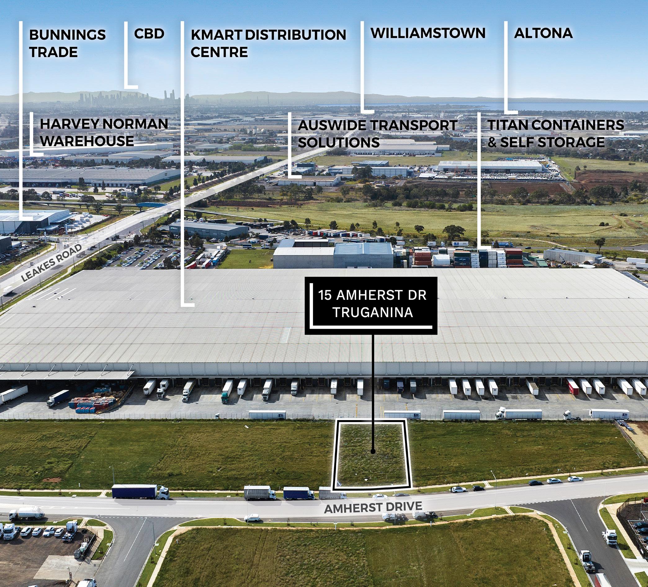
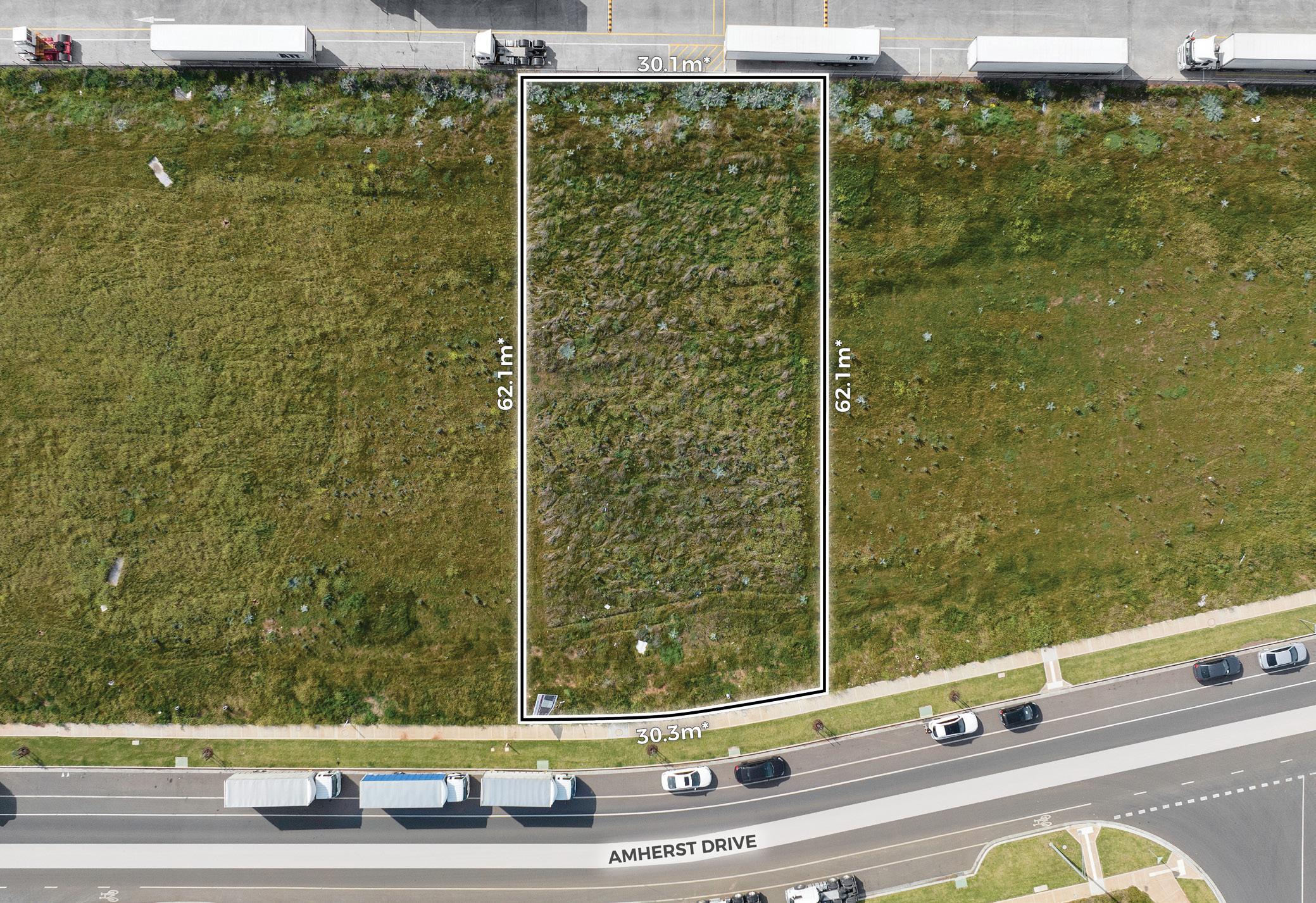
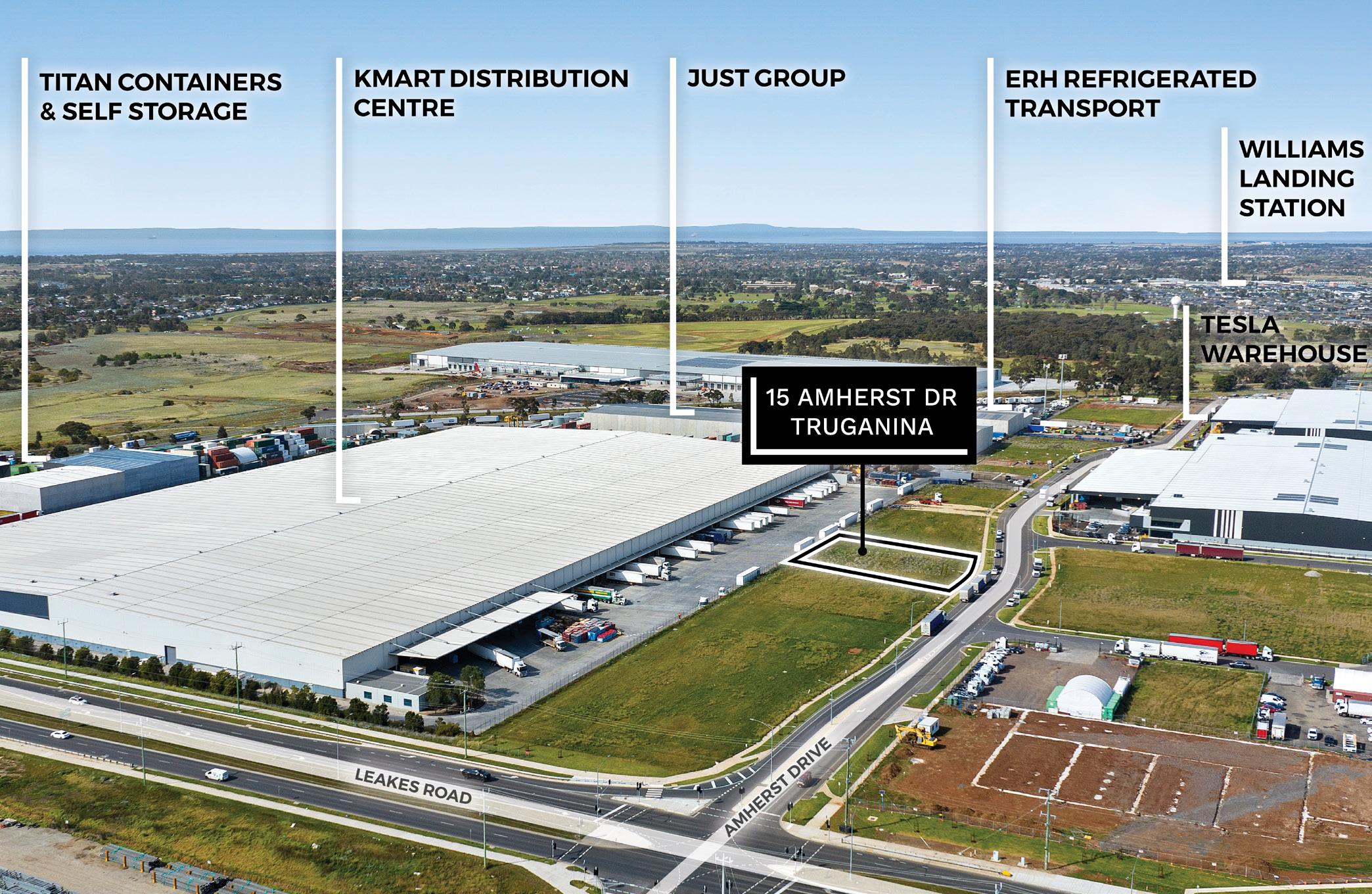
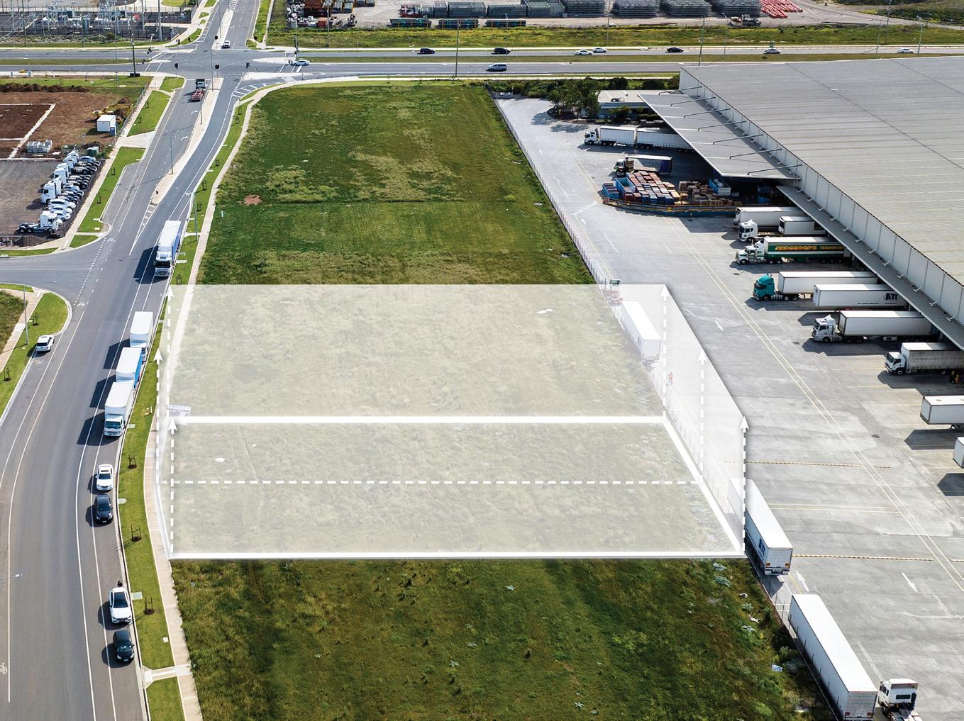
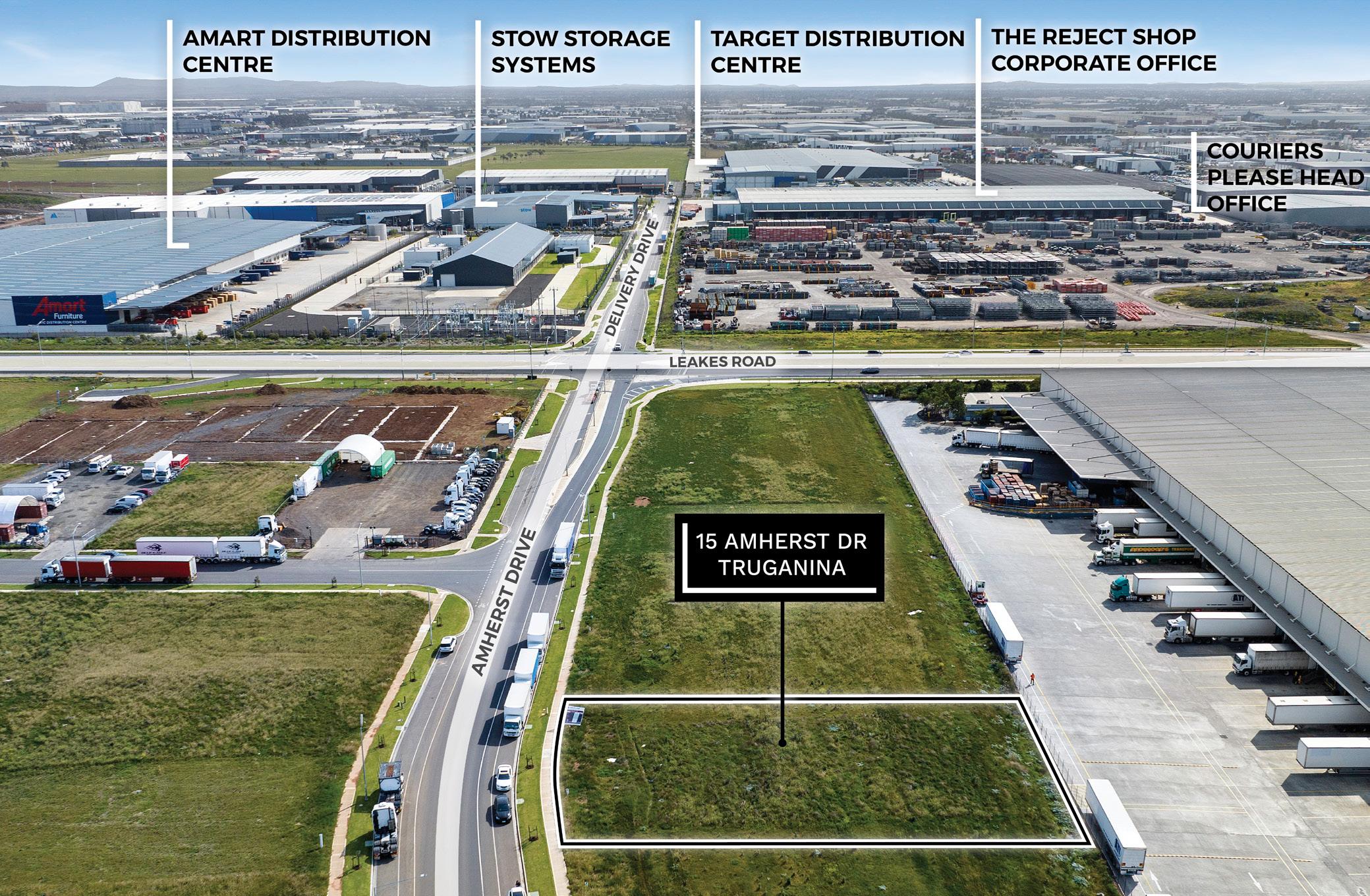
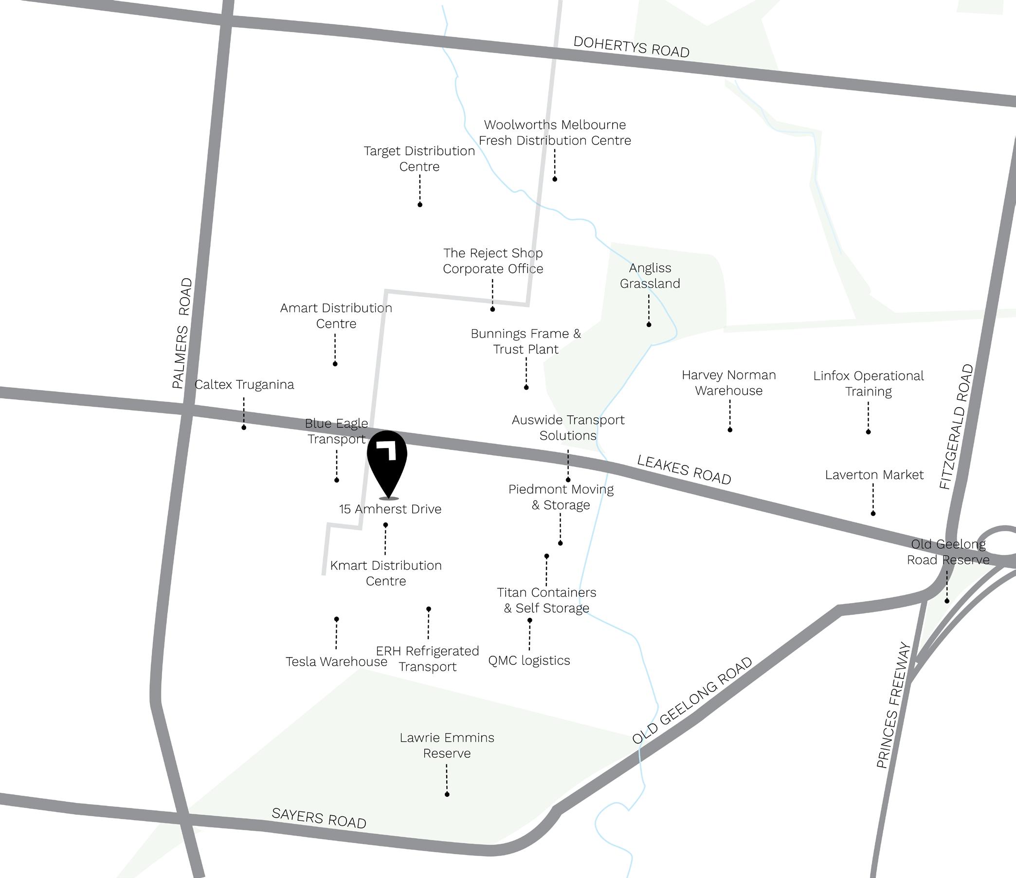
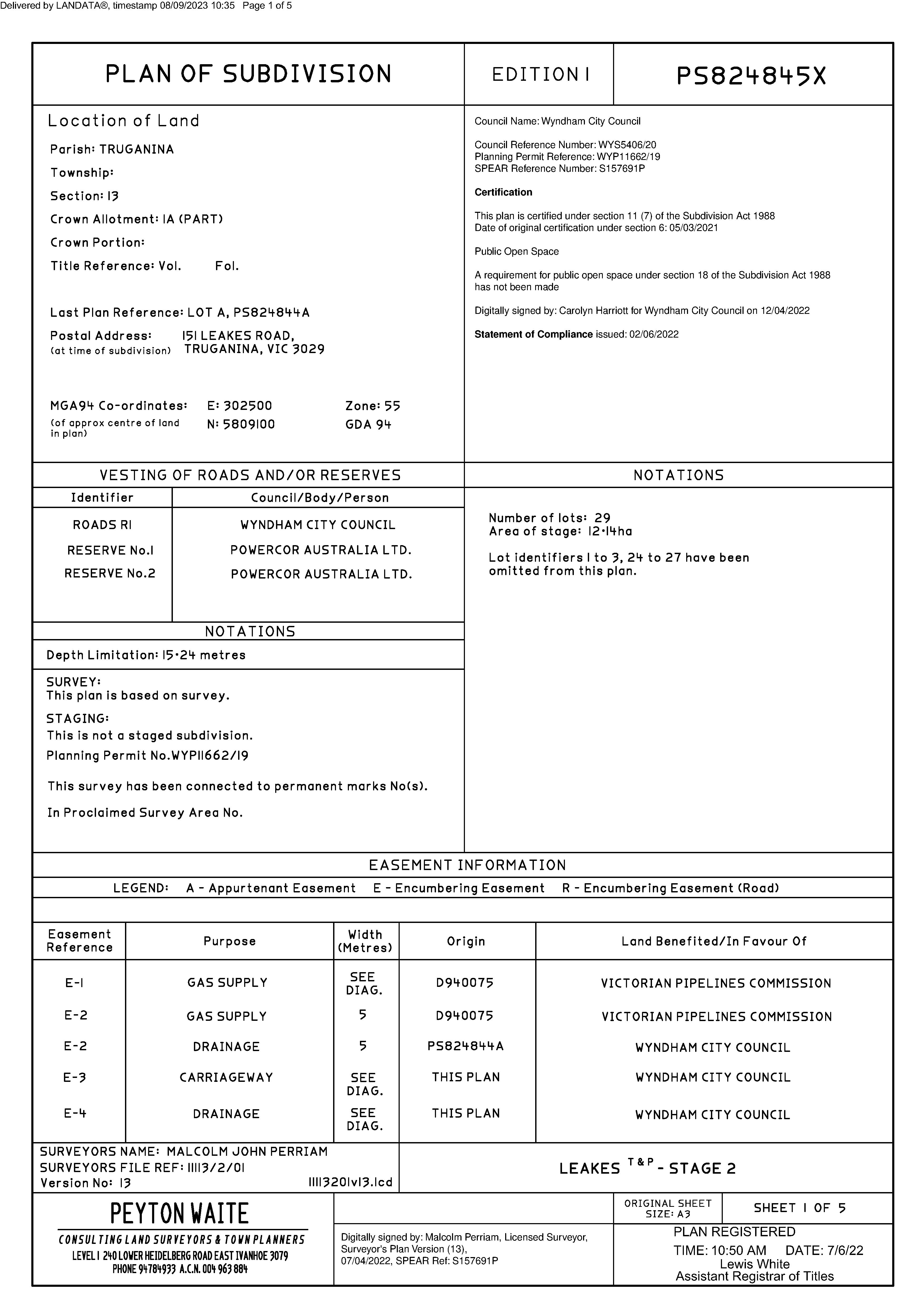
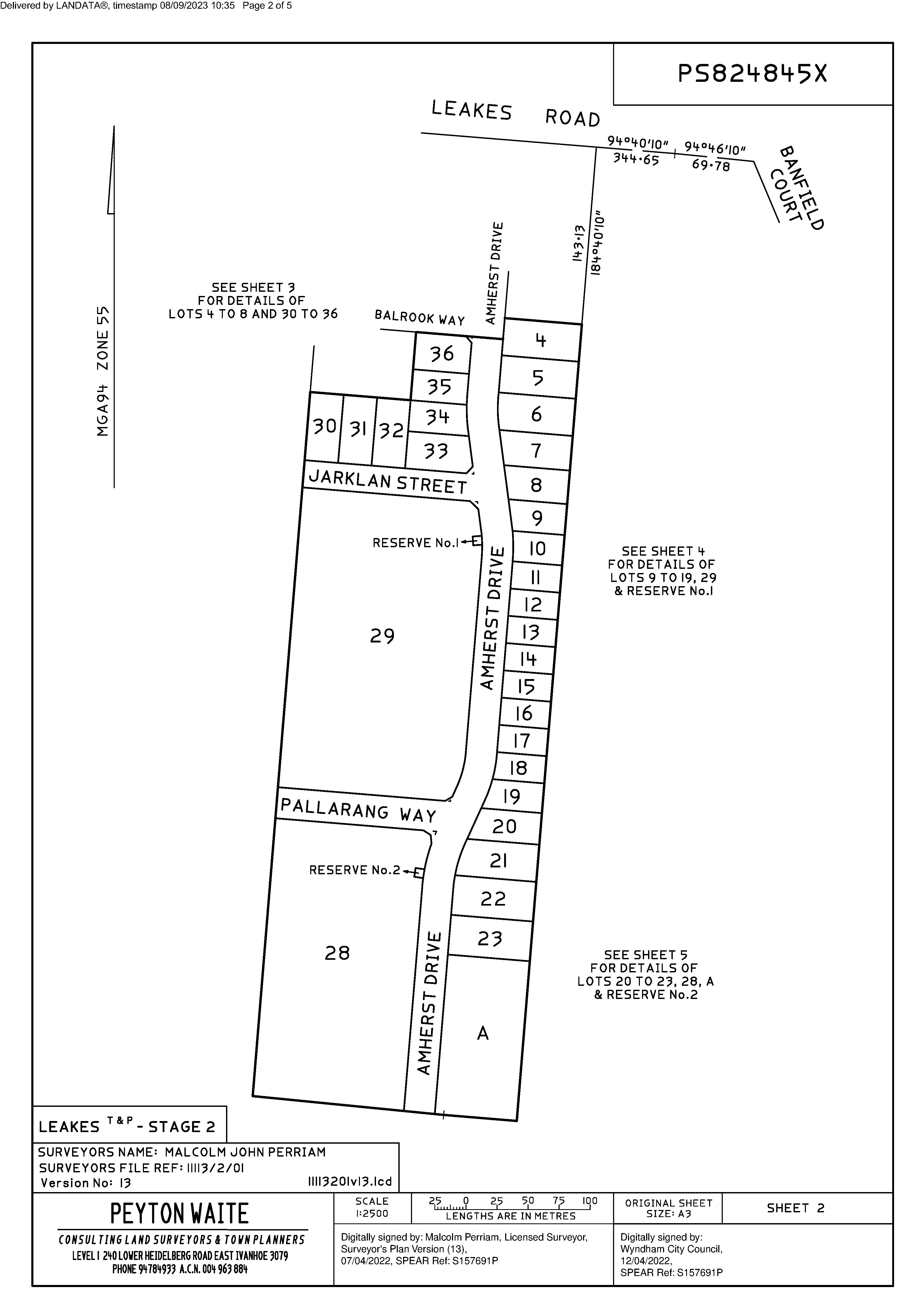
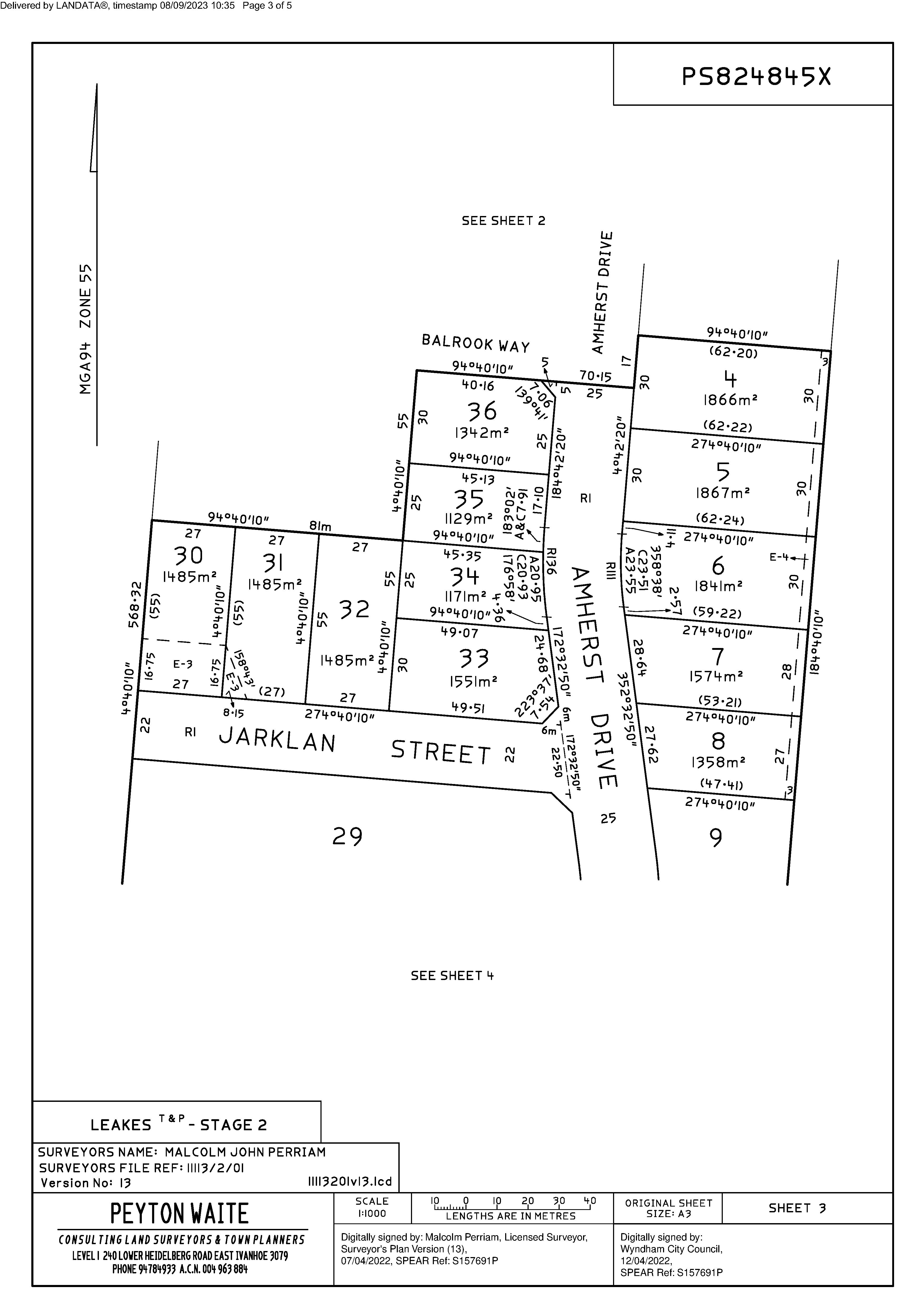
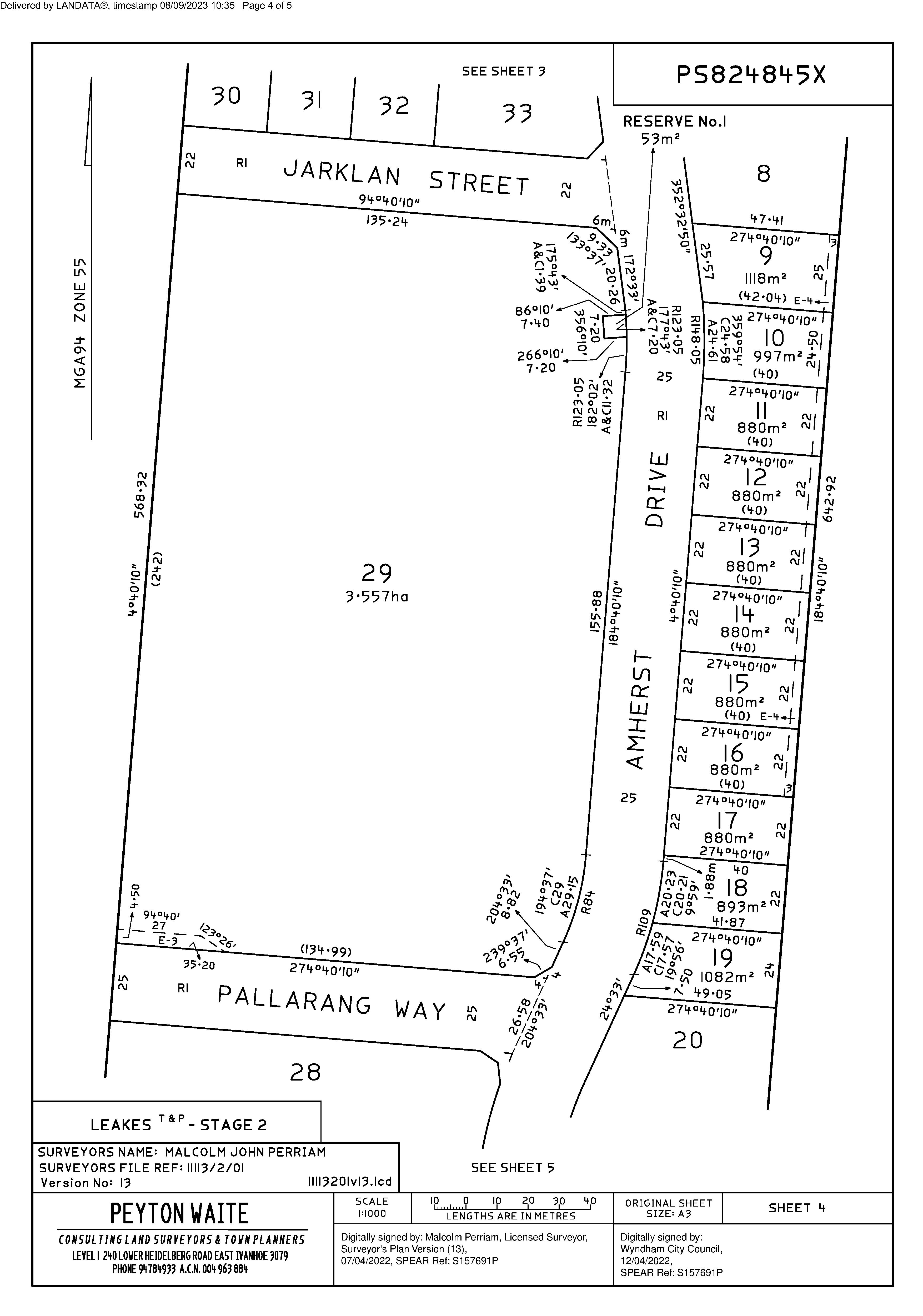
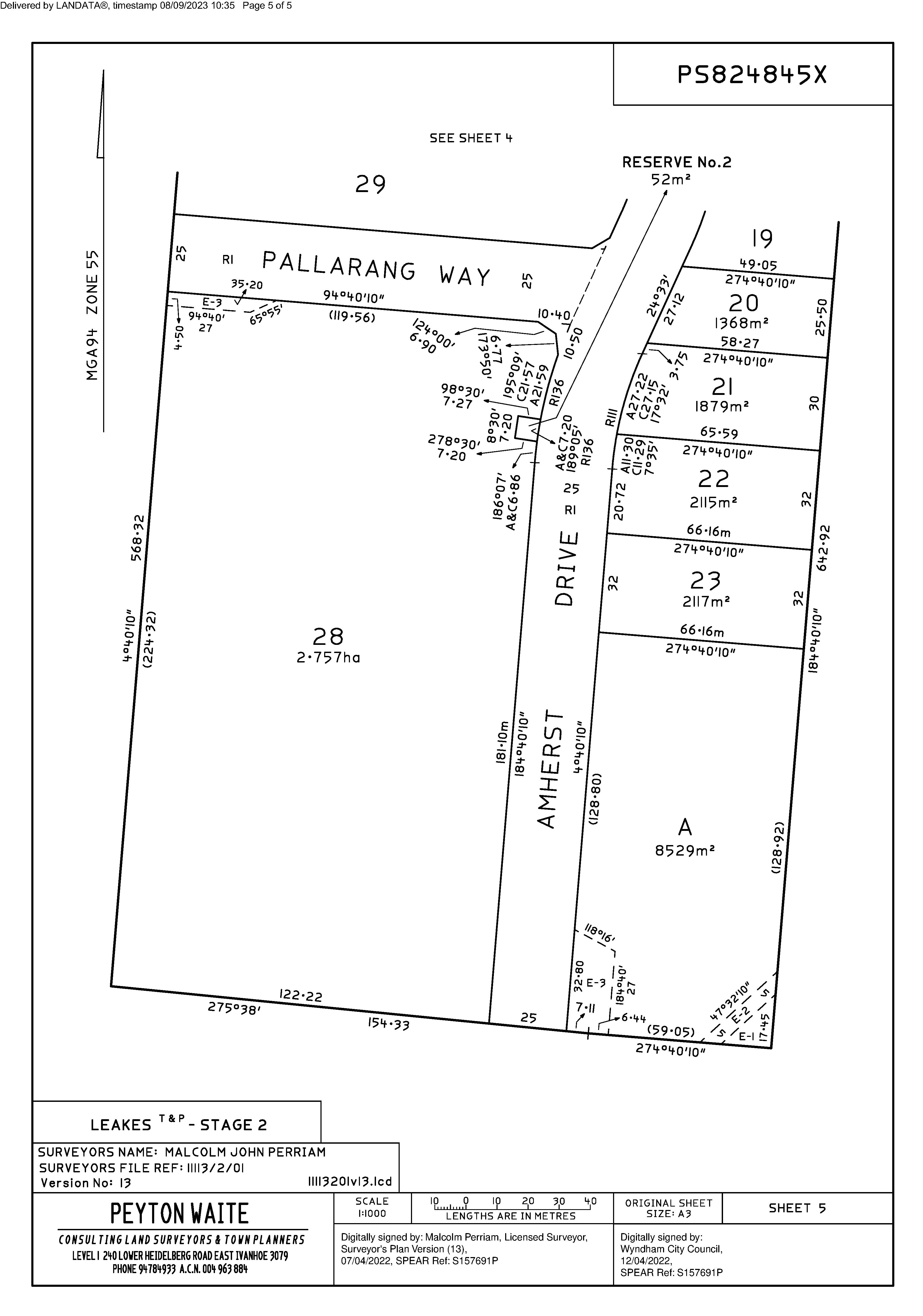
15 AMHERST DRIVE, TRUGANINA WWW.CVA.MELBOURNE
URBAN GROWTH ZONE
Shown on the planning scheme map as UGZ with a number (if shown).
Purpose
To implement the Municipal Planning Strategy and the Planning Policy Framework.
To manage the transition of non-urban land into urban land in accordance with a precinct structure plan.
To provide for a range of uses and the development of land generally in accordance with a precinct structure plan.
To contain urban use and development to areas identified for urban development in a precinct structure plan.
To provide for the continued non-urban use of the land until urban development in accordance with a precinct structure plan occurs.
To ensure that, before a precinct structure plan is applied, the use and development of land does not prejudice the future urban use and development of the land.
Application of provisions
Part A – No precinct structure plan applies
The provisions of Clauses 37.07-1 to 37.07-8 apply if no precinct structure plan applies to the land.
Part B – Precinct structure plan applies
The provisions of Clauses 37.07-9 to 37.07-16 apply if a precinct structure plan applies to the land.
Precinct structure plan provisions
A precinct structure plan applies to land when the precinct structure plan is incorporated in this scheme.
37.07-1
Table of uses
Section 1 – Permit not required
Use
Agriculture (other than Animal production, Apiculture, Domestic animal husbandry, Racing dog husbandry, Rice growing and Timber production)
Automated collection point
Condition
Bed and breakfast
Must meet the requirements of Clause 52.13-3 and 52.13-5. The gross floor area of all buildings must not exceed 50 square metres.
No more than 10 persons may be accommodated away from their normal place of residence.
At least 1 car parking space must be provided for each 2 persons able to be accommodated away from their normal place of residence.
WYNDHAM PLANNING SCHEME
31/07/2018 VC148
37.07
14/11/2022 VC227
Page 1 of 9
Dependent person’s unit
Must be the only Dependent person’s unit on the lot. Must meet the requirements of Clause 37.07-2.
Dwelling (other than Bed and breakfast)
Must be the only dwelling on the lot. The lot must be at least 40 hectares. Must meet the requirements of Clause 37.07-2.
Grazing animal production
Home based business
Informal outdoor recreation
Poultry farm
Must be no more than 100 poultry (not including emus or ostriches). Must be no more than 10 emus and ostriches.
Primary produce sales
Must not be within 100 metres of a dwelling in separate ownership. The area used for the display and sale of primary produce must not exceed 50 square metres.
Railway
Rural industry (other than Abattoir and Sawmill)
Must not have a gross floor area more than 200 square metres.
Must not be within 100 metres of a dwelling in separate ownership. Must not be a purpose shown listed in the table to Clause 53.10 with no threshold distance specified.
The land must be at least the following distances from land (not a road) which is in an Activity Centre Zone, Capital City Zone, Commercial 1 Zone, Docklands Zone, residential zone or Rural Living Zone, land used for a hospital, an education centre or a corrective institution or land in a Public Acquisition Overlay to be acquired for a hospital, an education cente or a corrective institution:
■
■ 30 metres, for a purpose not listed in the table to Clause 53.10.
The threshold distance, for a purpose listed in the table to Clause 53.10.
Must not:
■
■ Require a notification under the Occupational Health and Safety Regulations 2017.
Exceed a fire protection quantity under the Dangerous Goods (Storage and Handling) Regulations 2012.
■ Require a licence under the Dangerous Goods (Explosives) Regulations
WYNDHAM PLANNING SCHEME
Use Condition
Page 2 of 9
Use
Rural store
Condition 2011.
Require a licence under the Dangerous Goods (HCDG) Regulations 2016. ■
Must be used in conjunction with Agriculture.
Must be in a building, not a dwelling, and have a gross floor area of less than 100 square metres.
Must be the only Rural store on the lot.
Tramway
Any use listed in Clause 62.01 Must meet the requirements of Clause 62.01
Section 2 – Permit required
Use
Abattoir
Animal production (other than Grazing animal production, Intensive animal production and Poultry farm)
Broiler farm - if the Section 1 condition to Poultry farm is not met
Camping and caravan park
Car park
Cemetery
Crematorium
Dependent person’s unit – if the Section 1 condition is not met
Display home centre
Domestic animal boarding
Domestic animal husbandry (other than Domestic animal boarding)
Condition
Must be no more than 10,000 chickens.
Must be used in conjunction with another use in Section 1 or 2.
Must meet the requirements of Clause 37.07-2.
Must be no more than 5 animals.
WYNDHAM PLANNING SCHEME
Page 3 of 9
Use
Dwelling (other than Bed and breakfast) – if the Section 1 conditions are not met
Condition
Must be no more than 2 dwellings on the lot.
Must meet the requirements of Clause 37.07-2.
Education centre (other than child care centre)
Emergency services facility
Freeway service centre
Industry (other than Automated collection point and Rural Industry)
Racing dog husbandry
Trade supplies
Utility installation (other than Minor utility installation and Telecommunications facility)
Veterinary centre Warehouse (other than Rural store)
Winery
Any other use not in Section 1 or 3
Section 3 - Prohibited
Use
Must meet the requirements of Clause 53.05.
Must be no more than 5 animals.
Accommodation (other than Bed and breakfast, Camping and caravan park, Dependent person’s unit, Dwelling, Group accommodation, Host farm and Residential hotel)
Amusement parlour
Brothel
Child care centre
Cinema based entertainment facility
Intensive animal production
Nightclub
Office (other than Medical centre and Real estate agency)
Renewable energy facility
Retail premises (other than Landscape gardening supplies, Manufacturing sales, Market, Primary produce sales, Restaurant and Trade supplies)
Saleyard
WYNDHAM PLANNING SCHEME
Page 4 of 9
37.07-2
01/07/2021
VC203
Timber production
Use of land for a dwelling
A lot used for a dwelling must meet the following requirements:
37.07-3
16/04/2014
VC111
37.07-4
20/01/2022
VC205
Access to the dwelling must be provided via an all-weather road with dimensions adequate to accommodate emergency vehicles.
■ Each dwelling must be connected to reticulated sewerage, if available. If reticulated sewerage is not available, all wastewater from each dwelling must be treated and retained within the lot in accordance with the requirements of the Environment Protection Regulations under the Environment Protection Act 2017 for an on-site wastewater management system.
■ The dwelling must be connected to a reticulated potable water supply or have an alternative potable water supply with adequate storage for domestic use as well as for fire fighting purposes.
■ The dwelling must be connected to a reticulated electricity supply or have an alternative energy source.
■ These requirements also apply to a dependent person’s unit.
Subdivision
A permit is required to subdivide land. Each lot must be at least 40 hectares.
A permit may be granted to create smaller lots if any of the following apply:
■ The subdivision is the re-subdivision of existing lots and the number of lots is not increased.
■
The subdivision is to create a lot for an existing dwelling. The subdivision must be a two lot subdivision.
■ The subdivision is by a public authority or utility service provider to create a lot for a utility installation.
Buildings and works
A permit is required to construct or carry out any of the following:
■
■
A building or works associated with a use in Section 2 of Clause 37.07-1. This does not apply to:
■
■ Earthworks which change the rate of flow or the discharge point of water across a property boundary.
■ An out-building associated with an existing dwelling provided the floor area of the out-building is not more than 100 square metres.
An alteration or extension to an existing dwelling provided the floor area of the alteration or extension is no more than 100 square metres.
■ An alteration or extension to an existing building used for agriculture provided the floor area of the alteration or extension is no more than 200 square metres. The building must not be used to keep, board, breed or train animals.
■ Earthworks which increase the discharge of saline water.
A building which is within any of the following setbacks:
■
100 metres from a road in a Transport Zone 2 or land in a Public Acquisition Overlay if the Head, Transport for Victoria is the acquiring authority; and the purpose of the acquisition is for a road.
■ 40 metres from a road in a Transport Zone 3 or land in a Public Acquisition Overlay if the Head, Transport for Victoria is not the acquiring authority.
WYNDHAM PLANNING SCHEME Use
Page 5 of 9
37.07-5
08/08/2019
VC159
■
37.07-6
04/05/2022
VC210
■
■ 5 metres from any other boundary.
20 metres from any other road.
■ 100 metres from a dwelling not in the same ownership.
■ 100 metres from a waterway, wetlands or designated flood plain.
■ Permanent or fixed feeding infrastructure for seasonal or supplementary feeding for grazing animal production constructed within 100 metres of: A waterway, wetland or designated flood plain.
■ A dwelling not in the same ownership.
■ A residential zone or urban growth zone where a precinct structure plan applies.
Referral of applications
An application of the kind listed below must be referred in accordance with section 55 of the Act to the referral authority specified in Clause 66.03.
■
An application to use or develop land for any of the following: Display home centre.
■ Education centre.
■ Hospital.
■ Industry.
■ Medical centre.
■ Place of worship.
■ Real estate agency.
■ Warehouse.
■
■
An application to subdivide land to create a lot smaller than 40 hectares in area.
Environmental audit
Before a pre-school centre, primary school or secondary school commences on potentially contaminated land, or before the construction or carrying out of buildings and works in association with a pre-school centre, primary school or secondary school commences on potentially contaminated land:
■
■ An environmental audit statement under Part 8.3 of the Environment Protection Act 2017 must be issued stating that the land is suitable for the use or proposed use; or
A preliminary risk screen assessment statement in accordance with the Environment Protection Act 2017 must be issued stating that an environmental audit is not required for the use or proposed use; or
■ A certificate of environmental audit must be issued for the land in accordance with Part IXD of the Environment Protection Act 1970 ; or
■ A statement of environmental audit must be issued for the land in accordance with Part IXD of the Environment Protection Act 1970 stating that the environmental conditions of the land are suitable for the use or proposed use.
The requirement for a preliminary risk screen assessment statement, an environmental audit statement, a certificate of environmental audit or a statement of environmental audit in this provision does not apply to the construction or carrying out of buildings and works, if:
■
The buildings and works are associated with an existing pre-school centre, primary school or secondary school,
WYNDHAM PLANNING SCHEME
Page 6 of 9
included in Clause 62.02-1 or 62.02-2, and the soil is not disturbed;
■
37.07-7
31/07/2018
VC148
■
The buildings and works are required by the Environment Protection Authority or an environmental auditor appointed under the Environment Protection Act 2017 to make the site suitable for use; or
The buildings and works are reasonably required by an environmental auditor appointed under the Environment Protection Act 2017 or the Environment Protection Act 1970 to undertake a preliminary risk screen assessment or environmental audit.
Decision guidelines
Before deciding on an application to use or subdivide land, construct a building or construct or carry out works, in addition to the decision guidelines in Clause 65, the responsible authority must consider, as appropriate:
■
37.07-8
31/07/2018
VC148
37.07-9
03/02/2022
VC199
The Municipal Planning Strategy and the Planning Policy Framework.
■ The effect on the future urban development and use of the land, and adjacent or nearby land, having regard to: Any relevant Growth Corridor Framework Plan.
■ Any precinct structure plan being prepared for the area.
■
■ Any comments or directions of the referral authority.
■ Whether the proposal will prejudice the logical, efficient and orderly future urban development of the land, including the development of roads, public transport and other infrastructure.
■ The capability of the land to accommodate the proposed use or development, including the disposal of effluent.
■ How the use or development relates to sustainable land management.
■ Whether the site is suitable for the use or development.
■ The impact of the siting, design, height, bulk, colours and materials to be used on the natural environment, major roads, vistas and water features, future urban use of the land, and the measures to be undertaken to minimise any adverse impacts.
■ The impact on the character and appearance of the area or features of architectural, historic or scientific significance or of natural scenic beauty or importance.
■ The location and design of existing and proposed infrastructure including roads, public transport, walking and cycling networks, gas, water, drainage, telecommunications and sewerage facilities.
■ Whether the use and development will require new or upgraded infrastructure, including traffic management measures.
Signs
Sign requirements are at Clause 52.05. The zone is in Category 3. Despite the provisions of Clause 52.05-13, a permit may be granted, for a period of not more than 5 years, to display a sign that promotes the sale of land or dwellings.
Table of uses
Use of land
Any requirement in the Table of uses and any requirement specified in the schedule to this zone must be met. A permit granted must be generally in accordance with the precinct structure plan applying to the land.
Table of uses
WYNDHAM PLANNING SCHEME
Page 7 of 9
37.07-10
23/09/2011 VC77
Section 1 – Permit not required
Use Condition
Any use in Section 1 of a zone applied by the schedule to this zone
Must comply with any condition opposite the use in Section 1 of the applied zone.
Must comply with any condition or requirement specified in the schedule to this zone or in the precinct structure plan.
Any use specified in the schedule to this zone as a use for which a permit is not required
Section 2 – Permit required
Must comply with any condition or requirement specified in the schedule to this zone or in the precinct structure plan.
Use Condition
Any use in Section 2 of a zone applied by the schedule to this zone
Must comply with any condition opposite the use in Section 2 of the applied zone.
Must comply with any condition or requirement specified in the schedule to this zone or in the precinct structure plan.
Any use specified in the schedule to this zone as a use for which a permit is required
Any other use not in Section 1 or 3
Section 3 – Prohibited
Must comply with any condition or requirement specified in the schedule to this zone or in the precinct structure plan.
37.07-11
Any use in Section 3 of a zone applied by the schedule to this zone
Any use specified in the schedule to this zone
Subdivision of land
A permit is required to subdivide land. Any requirement in the schedule to this zone or the precinct structure plan must be met.
A permit granted must:
Be generally in accordance with the precinct structure plan applying to the land.
■ Include any conditions or requirements specified in the schedule to this zone or the precinct structure plan. ■
Buildings and works
If the schedule to this zone specifies:
WYNDHAM PLANNING SCHEME
Use
23/09/2011 VC77
Page 8 of 9
37.07-12
10/06/2008
VC48
37.07-13
25/05/2017
VC133
37.07-14
31/07/2018
VC148
37.07-15
10/06/2008
VC48
37.07-16
31/07/2018
VC148
■ Provisions relating to the development of land, those provisions apply to land in the circumstances specified in the schedule.
That the provisions of a zone apply to the development of land, the provisions of the zone apply to land in the circumstances specified in the schedule.
■ If the schedule to this zone specifies that a permit is required to construct a building or construct or carry out works, a permit granted must:
■
Be generally in accordance with the precinct structure plan applying to the land.
■ Include any conditions or requirements specified in the schedule to this zone or the precinct structure plan.
Application requirements
An application to use or subdivide land, construct a building or construct or carry out works, must be accompanied by any information specified in the schedule to this zone.
Exemption from notice and review
An application under any provision of this scheme which is generally in accordance with the precinct structure plan applying to the land is exempt from the notice requirements of section 52(1)(a), (b) and (d), the decision requirements of section 64(1), (2) and (3) and the review rights of section 82(1) of the Act, unless the schedule to this zone specifies otherwise.
Decision guidelines
Before deciding on an application to use or subdivide land, construct a building or construct or carry out works, in addition to the decision guidelines in Clause 65, the responsible authority must consider, as appropriate:
■ Any relevant Growth Area Framework Plan.
The Municipal Planning Strategy and the Planning Policy Framework.
■ The precinct structure plan applying to the land, including the vision and objectives of the precinct structure plan.
■
■ Any guidelines in the schedule to this zone.
Inconsistencies between specific and applied zone provisions
If there is an inconsistency between the specific provisions specified in the schedule to this zone and the provisions of a zone applied by the schedule to this zone, the specific provisions prevail to the extent of any inconsistency.
Signs
Sign requirements are at Clause 52.05. This zone is in the category specified in the schedule to this zone or, if no category is specified, Category 3.
WYNDHAM PLANNING SCHEME
Page 9 of 9
SCHEDULE 2 TO CLAUSE 37.07
URBAN GROWTH ZONE
11/08/2022
C248wynd
1.0
11/08/2022
C248wynd
Shown on the planning scheme map as UGZ2
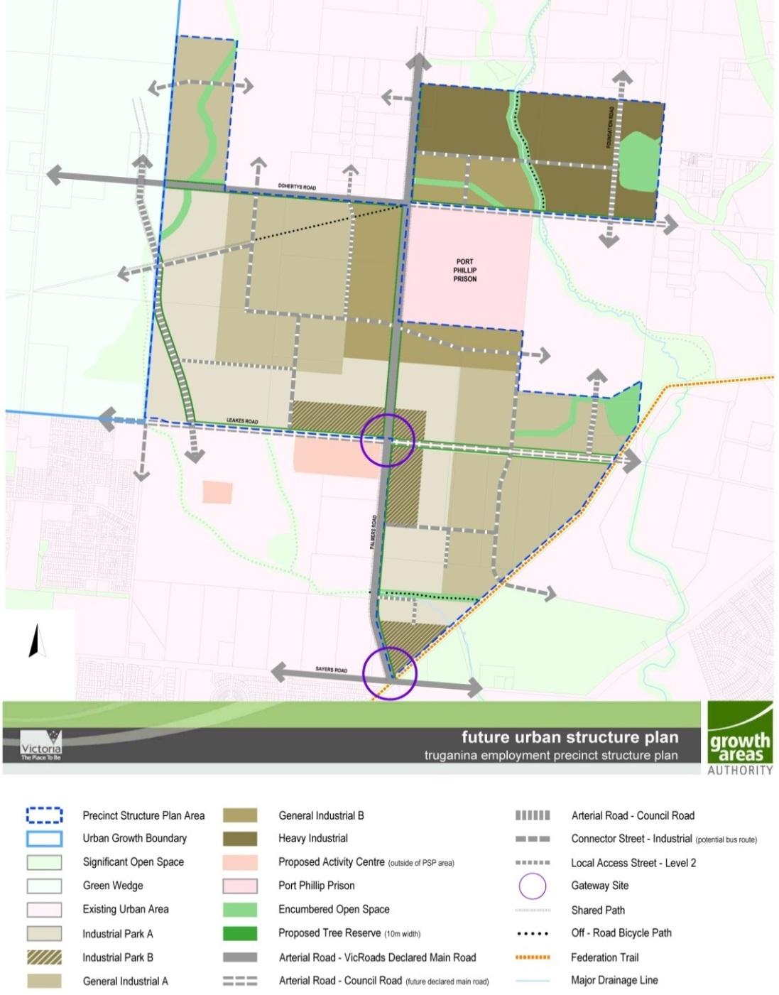
TRUGANINA EMPLOYMENT PRECINCT STRUCTURE PLAN (DECEMBER 2009)
The Plan
Plan 1 shows the future urban structure proposed in the Truganina Employment Precinct Structure Plan.
Plan 1 to Schedule 2 to Clause 37.07
WYNDHAM PLANNING SCHEME
C212
2.0 15/09/2016
Page 1 of 6
Use and development
2.1
11/08/2022
C248wynd
The land
The use and development provisions specified in this schedule apply where the land is in both UGZ2 on the planning scheme maps, and on Plan 2 of this schedule.
Plan 2 to Schedule 2 to Clause 37.07
2.2
11/08/2022
C248wynd
Applied zone provisions
The provisions of the following zones in this scheme apply to the use and subdivision of land, construction of a building, and construction or carrying out of works by reference to Plan 2 of this Schedule:
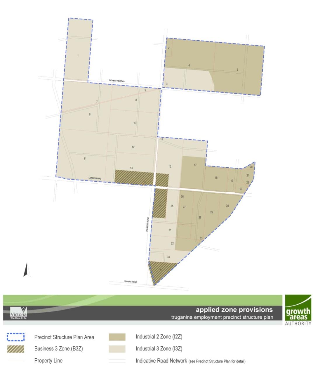
Table 1: Applied Zone provisions
Land as shown on plan 2 of this schedule
Applied zone provisions
WYNDHAM PLANNING SCHEME
Page 2 of 6
2.3
11/08/2022
C248wynd
Table 1: Applied Zone provisions
Land as shown on plan 2 of this schedule
Business 3 Zone
Industrial 2 Zone
Industrial 3 Zone
Leakes Road
Applied zone provisions
Clause 34.02 – Commercial 2 Zone
Clause 33.02 – Industrial 2
Clause 33.03 – Industrial 3
Clause 36.04 – Transport Zone 3
A reference to a planning scheme zone in an applied zone must be read as if it were a reference to an applied zone under this schedule.
Note:
e.g. The Commercial 2 Zone specifies ‘Supermarket’ as a section 1 and section 2 use with the condition, ‘The site must adjoin, or have access to, a road in a Transport Zone 2 or a Transport Zone 3.’ In this instance the condition should read as; ‘The site must adjoin, or have access to, a road in a Transport Zone 2 or a Transport Zone 3 or an applied Transport Zone 2 or Transport Zone 3 in the Urban Growth Zone schedule applying to the land’.
Specific provisions – Use of land
Use Requirement
Office No more than 500 square metres of leasable floor area may be permitted for any one premises on land shown as General Industrial A, General Industrial B or Heavy Industrial on Plan 1.
Cemetery/ Crematorium
A permit is not required to use or develop land for a cemetery/ crematorium on land known as Lot 7 TP7245, Doherty Road Truganina.
2.4 Specific provisions - Subdivision
Non specified
2.5 Specific provisions - Buildings and works
Non specified
2.6
11/08/2022
C248wynd
2.7
11/08/2022
C248wynd
Specific provisions – Resolution of doubt
If any doubt arises as to whether a provision specified in the schedule applies to land, a permit may be granted for any use or development if the responsible authority is satisfied that the use or development is in accordance with the incorporated Truganina Employment Precinct Structure Plan.
Application requirements - Salvage and translocation
All applications for subdivision of land identified as ‘Potential Salvage Operations’ by the MSA Map Share tool must
WYNDHAM PLANNING SCHEME
Page 3 of 6
2.8
11/08/2022
C248wynd
3.0
11/08/2022
C248wynd
be accompanied by evidence that a salvage enquiry form has been submitted to the Department of Environment, Land, Water, and Planning.
Condition – Salvage and translocation
Prior to the commencement of development, a salvage inquiry form must be submitted to the Secretary to the Department of Environment, Land, Water and Planning (as constituted under Part 2 of the Conservation, Forests and Lands Act 1987 ) (Secretary), and where required the Secretary must be permitted to access the land to conduct salvage operations, in accordance with the requirements of the Salvage and Translocation Protocol for Melbourne’s Growth Corridors 2018 (Department of Environment, Land, Water and Planning, 2018).
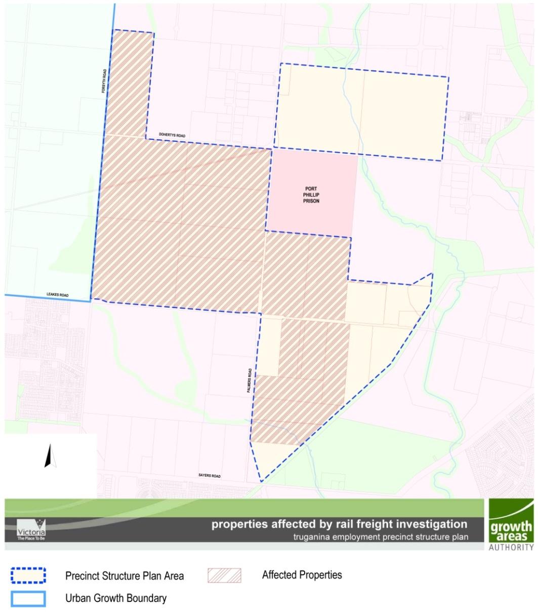
Referral of applications
An application on land shown as ‘Affected Properties’ in Plan 3 to this schedule must be referred in accordance with section 55 of the Act to the Director of Public Transport.
WYNDHAM PLANNING SCHEME
Page 4 of 6
4.0
11/08/2022
C248wynd
Plan 3 to Schedule 2 to Clause 37.07
5.0
11/08/2022
C248wynd
Notice of applications
In accordance with Section 52(1)(c) of the Act, notice of an application on land shown as ‘General Industrial B’ on Plan 1 to this schedule to use land, subdivide land or to construct a building or construct or carry out works must be given to the Secretary of the Department of Justice unless otherwise agreed in writing between the responsible authority and the Secretary. The notice must be accompanied by a copy of the application, existing conditions and development plans.
Signs
Sign requirements are at Clause 52.05. Land in UGZ2 is in Category 2.
5.1 Specific provision - land sales signs
WYNDHAM PLANNING SCHEME
Page 5 of 6
6.0
11/08/2022
C248wynd
Despite the provisions of Clause 52.05, signs promoting the sale of land that are displayed on the land (or on adjoining land in the same ownership) may be displayed without a permit provided:
■ Only one sign is displayed per road frontage. Where the property has a road frontage of more than 150 metres multiple signs may be erected provided there is a minimum of 150 metres distance between each sign, with a total of not more than 4 signs per frontage.
The display area for each sign does not exceed 10 square metres.
■ The sign is not animated, scrolling, electronic or internally illuminated sign.
■ The sign is not displayed longer than 21 days after the sale (not settlement) of the last lot.
■ The sign is setback a minimum of 750mm from the property boundary.
■ A permit may be granted to display a sign promoting the sale of land with an area greater than 10 square metres.
Decision guidelines
None specified.
WYNDHAM PLANNING SCHEME
Page 6 of 6
45.06
DEVELOPMENT CONTRIBUTIONS PLAN OVERLAY
Shown on the planning scheme map as DCPO with a number.
Purpose
To implement the Municipal Planning Strategy and the Planning Policy Framework.
To identify areas which require the preparation of a development contributions plan for the purpose of levying contributions for the provision of works, services and facilities before development can commence.
45.06-1
19/01/2006
VC37
Development contributions plan
A permit must not be granted to subdivide land, construct a building or construct or carry out works until a development contributions plan has been incorporated into this scheme. This does not apply to the construction of a building, the construction or carrying out of works or a subdivision specifically excluded by a schedule to this overlay.
A permit granted must:
■
45.06-2
19/01/2006
VC37
Be consistent with the provisions of the relevant development contributions plan.
■ Include any conditions required to give effect to any contributions or levies imposed, conditions or requirements set out in the relevant schedule to this overlay.
Preparation of a development contributions plan
The development contributions plan may consist of plans or other documents and may, with the agreement of the planning authority, be prepared and implemented in stages.
The development contributions plan must:
■ Set out the works, services and facilities to be funded through the plan, including the staging of the provision of those works, services and facilities.
Specify the area to which the plan applies.
■ Relate the need for the works, services or facilities to the proposed development of land in the area.
■ Specify the estimated costs of each of the works, services and facilities.
■ Specify the proportion of the total estimated costs of the works, services and facilities which is to be funded by a development infrastructure levy or community infrastructure levy or both.
■ Specify the land in the area and the types of development in respect of which a levy is payable and the method for determining the levy payable in respect of any development of land.
■ Provide for the procedures for the collection of a development infrastructure levy in respect to any development for which a permit is not required.
■ The development contributions plan may:
■
Exempt certain land or certain types of development from payment of a development infrastructure levy or community infrastructure levy or both.
■ Provide for different rates or amounts of levy to be payable in respect of different types of development of land or different parts of the area.
WYNDHAM PLANNING SCHEME
31/07/2018 VC148
Page 1 of 1
11/08/2022
C248wynd
SCHEDULE 9 TO CLAUSE 45.06 DEVELOPMENT CONTRIBUTIONS PLAN OVERLAY
Shown on the planning scheme map as DCPO9.
TRUGANINA EMPLOYMENT PRECINCT DEVELOPMENT CONTRIBUTIONS PLAN
1.0
22/12/2009
C124
Area covered by this development contributions plan
Land in the City of Wyndham shown on the Planning Scheme maps as being within Schedule 9 to the Development Contributions Plan Overlay.
2.0
11/08/2022
C248wynd
Summary of costs in July 2009 dollars
WYNDHAM PLANNING SCHEME
Facility Total cost $ Time of provision Actual cost contribution attributable to development $ Proportion of cost attributable to development % Distributor roads $67,265,282 Refer to details in the Truganina Employment Precinct Development Contributions. $65,739,201 98% Traffic management works $13,244,326 Refer to details in the Truganina Employment Precinct Development Contributions. $9,900,394 75% Streetscape & environment $1,525,000 $1,525,000 100% Parks Active open space Page 1 of 3
Total cost $
WYNDHAM PLANNING SCHEME
Proportion
development
Community
Drainage Other TOTAL
$77,164,595 94% 3.0
C248wynd Summary
Facility Levies Payable By The Development ($) Development infrastructure Community infrastructure All infrastructure residential non-residential residential non-residential residential non-residential Distributor roads $85,198.55 $85,198.55 Traffic management works $12,830.99 $12,830.99 Streetscape & environment 1,976.41 1,976.41 Parks Page 2 of 3
Facility
Time of provision Actual cost contribution attributable to development $
of cost attributable to
%
activity centres
$82,034,608
11/08/2022
of contributions in July 2009 dollars
All levies payable by the development are per net developable hectare as set out in the Truganina Employment Precinct Development Contributions Plan.
Land or development excluded from development contributions plan
None specified.
5.0 Indexation
All contributions stated in dollar values in this Schedule are to be indexed in line with the Commonwealth Statisticians’ Consumer Price Index (All Groups) for Melbourne (CPI) from the July quarter 2009.
Note: This schedule sets out a summary of the costs and contributions prescribed in the development contributions plan. Refer to the incorporated development contributions plan for full details
WYNDHAM PLANNING SCHEME Facility Levies Payable By The Development ($) Development infrastructure Community infrastructure All infrastructure residential non-residential residential non-residential residential non-residential Active open space Community activity centres Drainage Other TOTAL $100,005.00 $100,005.00
11/08/2022
4.0
C248wynd
Page 3 of 3