Page 82 • September 1, 2021 • www.constructionequipmentguide.com • CONSTRUCTION EQUIPMENT GUIDE
GPR Scans for Anomalies for Historic Church Renovation In September 2018, architects were hired by the Congregational Church of Hollis to help design and oversee the construction project for a church expansion. The architects used ground penetrating radar (GPR) during the preliminary planning process for an expansion to a historic church in Hollis, N.H. Using GPR early in the planning process helped to ensure excavation would not disturb any graves. It also minimized the risks of encountering subsurface conditions that could result in delays and increased construction costs. Architect Looks for Ways to Identify Potential Risks GPR helps with surveying sensitive archeological sites remotely and non-destructively before excavating. It can pinpoint the places to excavate and indicate which areas should be avoided. Scanning prior to excavating saves time and money and helps to find unknown objects. Dennis Mires, of Dennis Mires, PA The Architects, used GPR as part of preliminary planning for an expansion of the Congregational Church of Hollis. The church, which was originally founded in 1741, is constrained within a small area between Monument Square, the church cemetery and the town library. The church was proposing an expansion to the front of the church and a lower level patio area. One part of the expansion is located near a cemetery wall and required approval from several town agencies. The architect wanted to use GPR to identify any potential risks ahead of time. They were especially interested in avoiding burial remains while digging near the historic cemetery, or of coming across any ledge that might be in the construction area. “We were very interested in demonstrating to the Hollis Cemetery Trustees and the Select Board that we are being proactive in minimizing surprises and making appropriate plans to reduce delays and costs during construction,” explained Mires. The architect called on local GPR manufacturer Geophysical Survey Systems Inc (GSSI) to conduct a survey in two areas: the right-side yard near the cemetery and the front yard near the church’s existing handicap drop off area. The survey was conducted using GSSI’s UtilityScan GPR system, which is the smallest utility locator on the market. Due to the ease of use, size and cost of this system, it’s used by utility contractors, environmental specialists and archaeologists around the world. The primary concern was to determine if any burials existed outside of the cemetery boundaries on the right-side yard. Historical burials are typically smaller than 4 to 6 ft. in length and can vary in depths. Therefore, the team was tasked to look for features in oblong shapes about 1 to 4 ft. long. On the right side yard, GSSI collected data by creating a grid formation of 82 by 82 ft. with lines spaced at 9.8 in. apart. This method was selected to ensure high resolution data. The data suggested an anomaly and the team recommended further investigation of the top left-hand corner prior to construction. The anomaly’s geometric shape (a 10- by 10ft. block) and shallow depth suggested that it could be an old building foundation. In the 1920s, there were a number of out-buildings associated with the church, which could
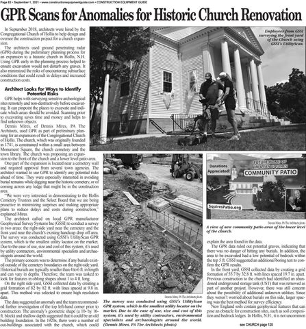
Employees from GSSI surveying the front yard of the Church using GSSI’s UtilityScan.
Dennis Mires, PA The Architects photo
A view of new community patio area of the lower level of the church.
Dennis Mires, PA The Architects photo
The survey was conducted using GSSI’s UtilityScan GPR system, which is the smallest utility locator on the market. Due to the ease of use, size and cost of this system, it’s used by utility contractors, environmental specialists and archaeologists around the world. (Dennis Mires, PA The Architects photo)
explain the area found in the data. The GPR data ruled out potential graves, indicating that there was no danger of hitting any burials. In addition, the area to be excavated had a low potential of bedrock within the top 5 ft. GSSI suggested an additional boring test to confirm the GPR results. In the front yard, GSSI collected data by creating a grid formation of 55.7 by 32.8 ft. with lines spaced 19.7 in. apart. Previous construction to the church had identified an abandoned underground storage tank (UST) that was removed as part of another project. However, there was still concern about the possibility of additional unknown utilities. Since they weren’t worried about burials on this side, larger spacing was the best method for survey efficiency. New England soils contain geophysical features that can pose an obstacle for construction sites, such as soil composition and bedrock ledges. In Hollis, N.H., it is not uncommon see CHURCH page 120


