
SUKAT NG KALIKASAN: COUNTING WHAT COUNTS
The Sukat ng Kalikasan (SnK) Framework was pilot-tested in five key biodiversity areas: (1) Masinloc-Oyon Bay Protected Landscape and Seascape (MOBPLS); (2) Cleopatra’s Needle Forest Reserve (CNFR); (3) Puerto Princesa Subterranean River and National Park (PPSRNP); (4) Mt. Mantalingahan Protected Landscape (MMPL); and (5) Siargao Island Protected Landscape and Seascape (SIPLAS). The presence of SnK categories and subcategories was assessed following the SnK Toolkit. The results and outputs for each PA are presented in the succeeding sections.


MASINLOC-OYON BAY PROTECTED LANDSCAPE AND SEASCAPE (MOBPLS)
Changes in benthic cover were detected after assessing, mapping, and analyzing (Figure 1) ecosystems’ and habitats’ conditions between 2018 and 2022. From 2018 to 2022, an increase in coral cover was evident, while seagrass beds had minimal changes in extent (Figure 2). As fish catch is a major economic contributor in the area, fish provisioning services were estimated (Sukat 5.5). It was found that coral reefs had the largest physical contribution (i.e. fish biomass) compared to seagrass beds, mangroves, and the open sea. However, the total resource rent estimates (Figure 3) revealed negative values for each marine ecosystem, signaling severe resource depletion and downward trends in economic benefits for municipal fishers in the area. Stringent regulations such as gear restrictions and size limits should be put in place for these trends to be reversed.

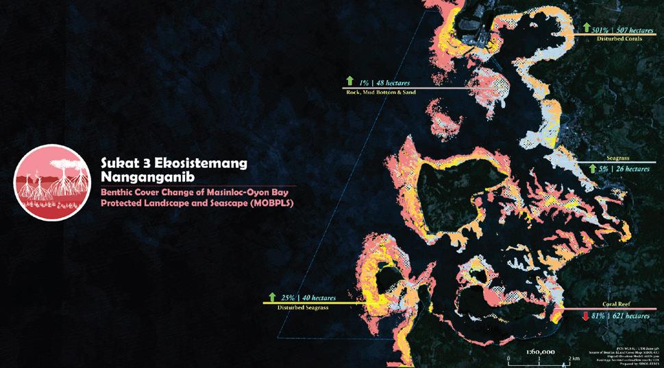

Figure 1. Map of benthic cover in MOBPLS, with an overall accuracy of 85%. For marine ecosystems, a map of the benthic cover is required as an output for Sukat 2 at the Gold level.
Figure 2. Map showing the changes of benthic cover in MOBPLS using 2018 and 2022 data. A map showing the ecosystem/habitat change is necessary for Sukat 3 at the Platinum level.
Figure 3. Total resource rent estimates by ecosystem and benthic cover change in MOBPLS. Total resource rent estimates are necessary outputs for Sukat 5.5 at the Platinum level.
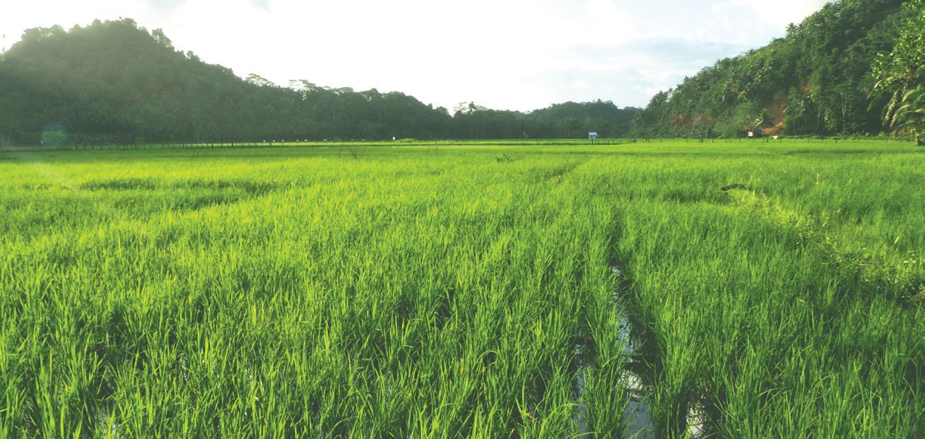
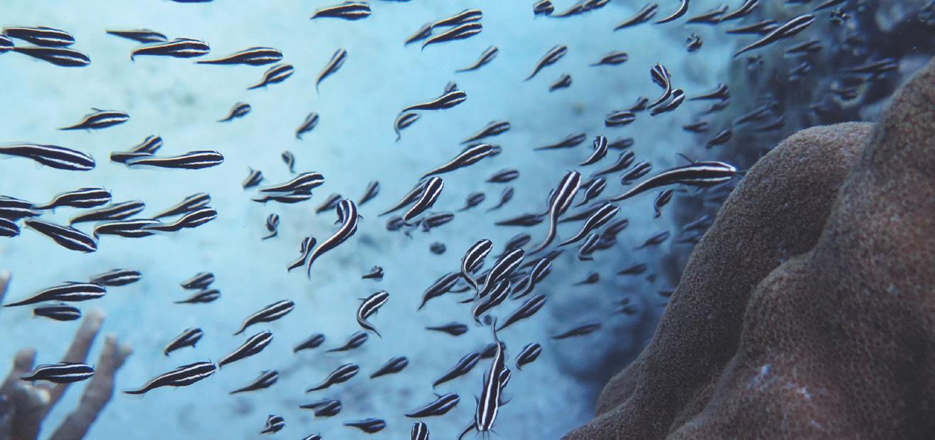
Photo courtesy of Michelle Baird of USAID SIBOL Project
Photo courtesy of John Lister Bibar of Center for Conservation Innovations Ph
Photo courtesy of John Lister Bibar of Center for Conservation Innovations Ph
Photo courtesy of Michelle Baird of USAID SIBOL Project
Photo courtesy of Mary Ann Bautista of Center for Conservation Innovations Ph
CLEOPATRA’S NEEDLE FOREST RESERVE (CNFR)
Cleopatra’s Needle Forest Reserve1 is one of three pilot sites that suffered from extensive damages after Typhoon Odette in December 2021. As can be gleaned from Sukat 2 (Figure 4) and Sukat 3 (Figure 5) ecosystem maps, forests were heavily affected post-Odette, with 91% (or 18,729 ha) and 30% (or 15,056 ha) reduction in open forests and closed forests, respectively. Less than half (30% or 204 ha) of the settlements were damaged, while coconut plantations were completely devastated. The reduced extent and quality of forest cover resulted in shrinkage and fragmentation of suitable habitats for rare, threatened, and endemic (RTE; Sukat 1) species like the Palawan Flycatcher (Ficedula platenae) and the Palawan Hornbill (Anthracoceros marchei). Pre-Odette, these species were widely distributed in the forested areas of CNFR. The post-Odette impacts caused further reduction in the extent of suitable habitats, especially in lowland areas (Figure 6). Moreover, the post-Odette decline in forest cover means a decline in net GHG emissions (Sukat 4.1). In 2021, the value of carbon stock’s estimate was PhP 185 billion and by 2023, it reduced by PHP 28 billion to PhP 157 billion (Figure 7).
Harvesting of almaciga resin is of major economic use, particularly for indigenous peoples. Resource rent estimates (Figure 8) showed a positive value, indicating a positive contribution of the extent of Almaciga (Agathis philippinensis) to NTFP provisioning services (Sukat 5.6). Rent estimates could, however, be improved in the future by imposing higher farmgate prices. This can hopefully be achieved if tapping techniques are improved, thus raising the quality of resin being sustainably harvested from the forest.
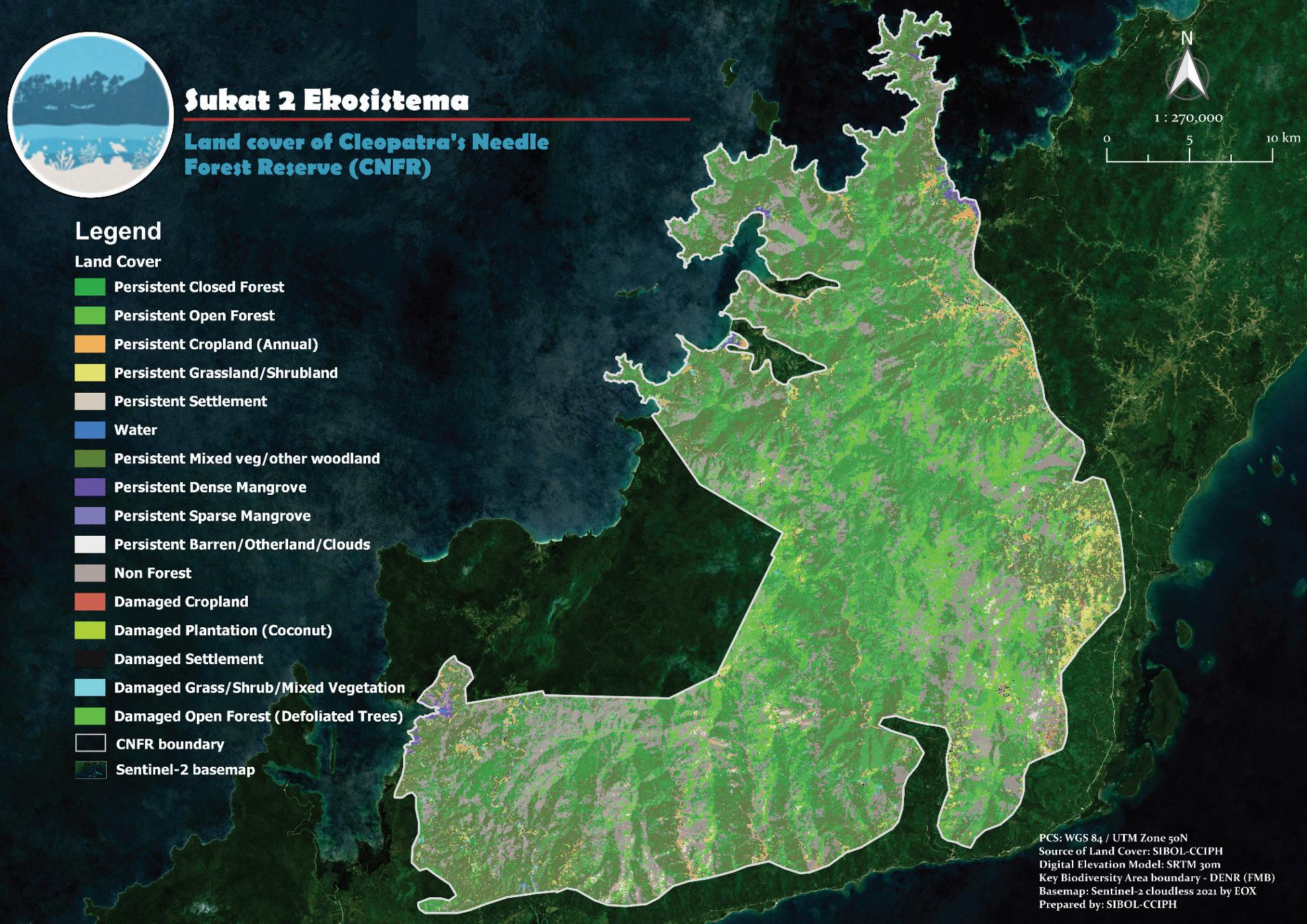
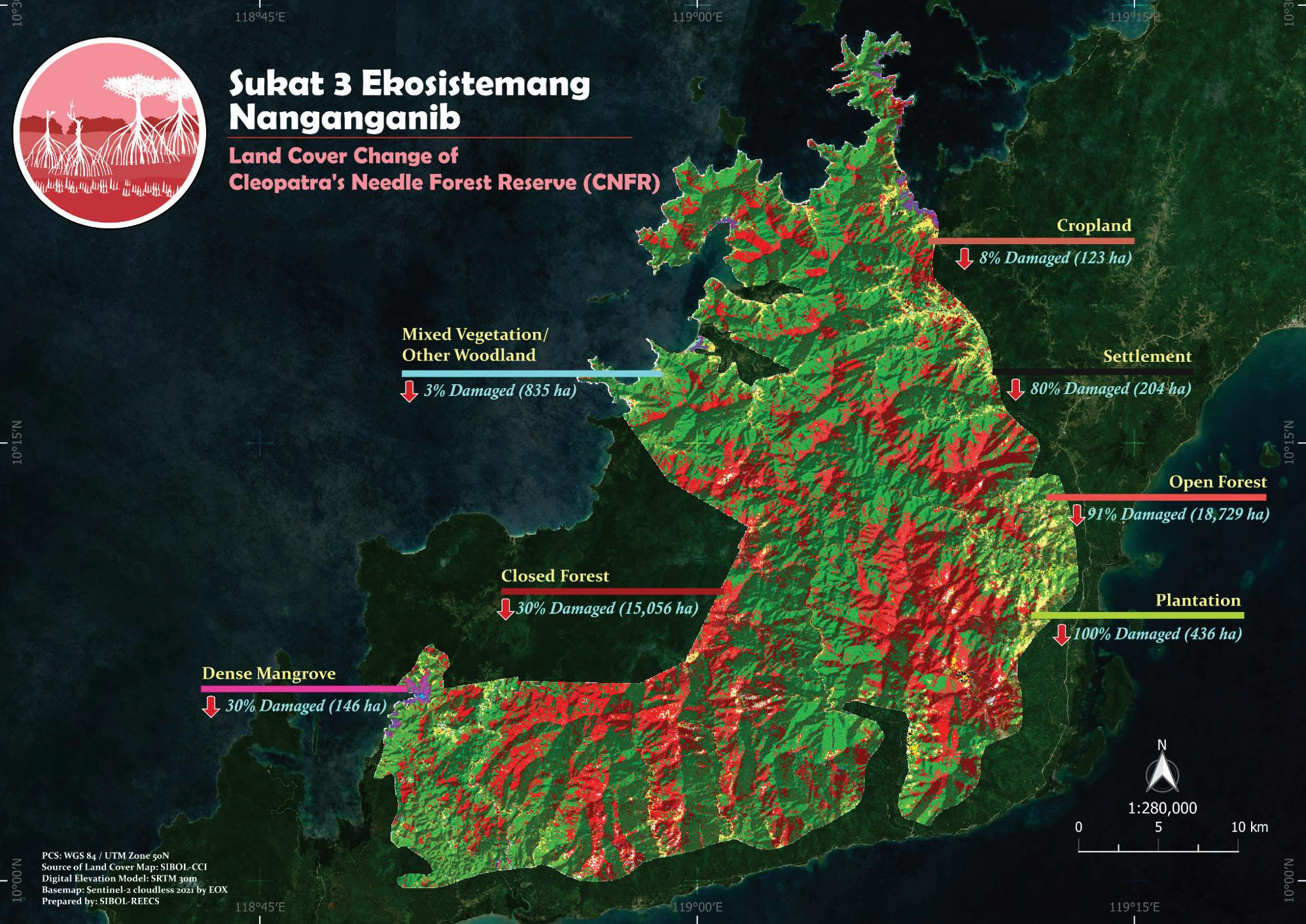
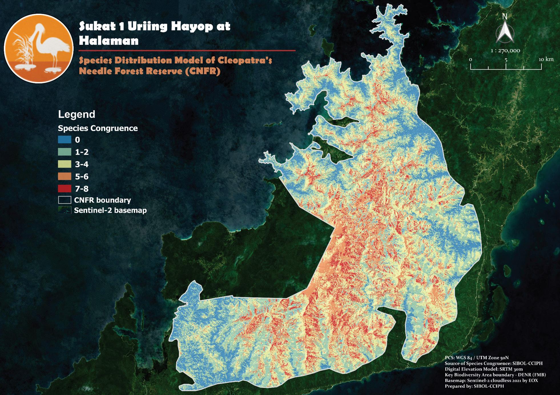
Figure 4. Map showing the land cover classes in CNFR and the damages thereto, which resulted from the impacts of Typhoon Odette. For terrestrial ecosystems, an ecosystem map is required as an output for Sukat 2.
CNFR is a key biodiversity area consisting of the protected Cleopatra’s Needle Critical Habitat in Puerto Princesa City, and portions of the municipalities of Roxas and San Vicente, Palawan.
Figure 5. Map of the land cover change in CNFR as a result of Typhoon Odette, using 2021 and 2022 land cover data. An ecosystem change map was used to determine the presence of Sukat 3.
Figure 6. Post-Odette species congruence map of eight RTE species in CNFR. Red pixels denote high species niche overlaps. Amalgamatingthespeciesdistributionmodels(SDMs)ofRTEspeciesgenerates a species congruence map. SDMs of priority RTE species are necessary for Sukat 1 at the Gold level.
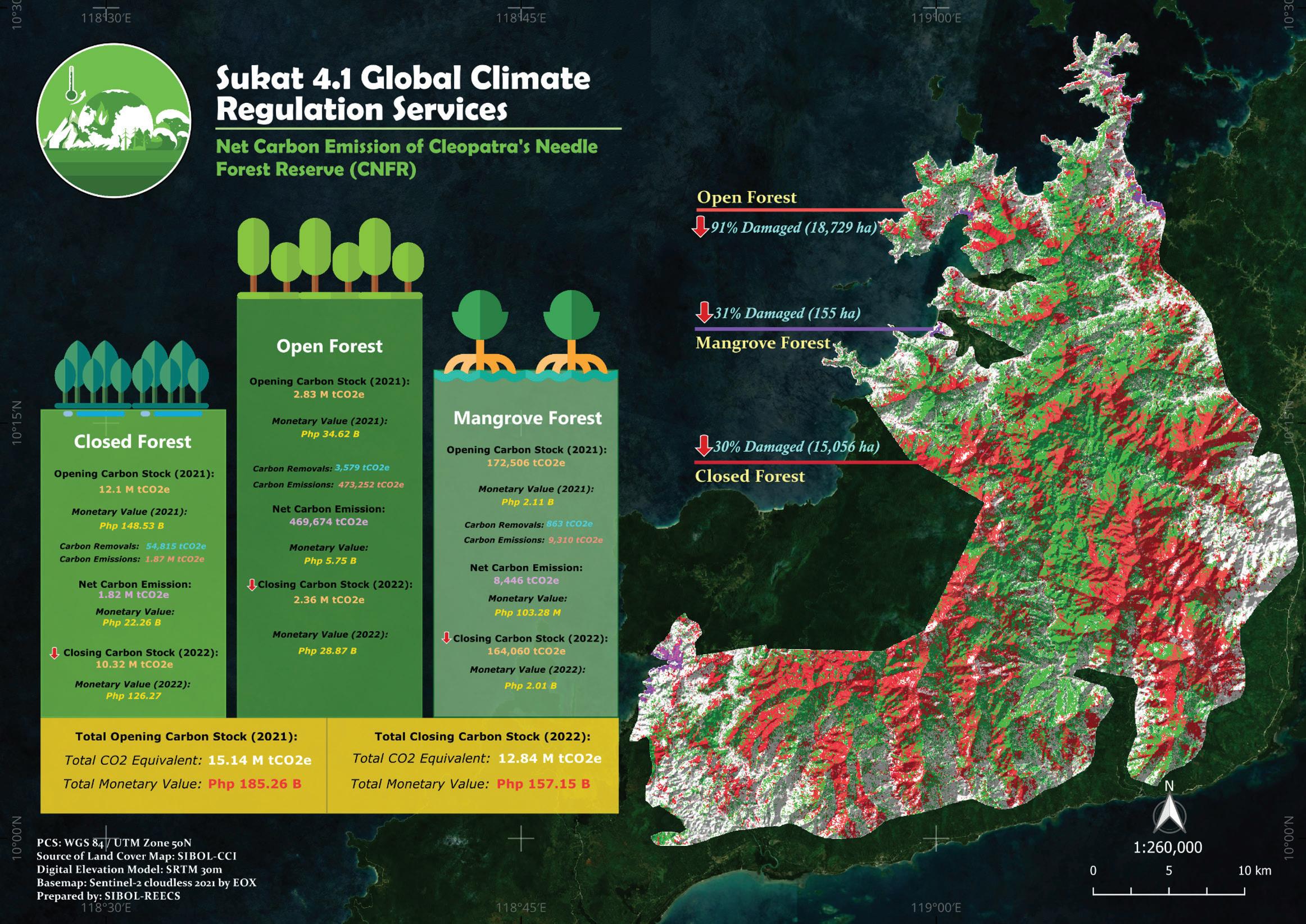
Figure 7. Net GHG emission values in CNFR based on the computed opening (2021) and closing (2022) carbon stocks. At the Platinum level, Sukat 4.1 requires quantification of the total carbon stock from various carbon pools in the area to compute the net emission values based on the social cost of carbon.
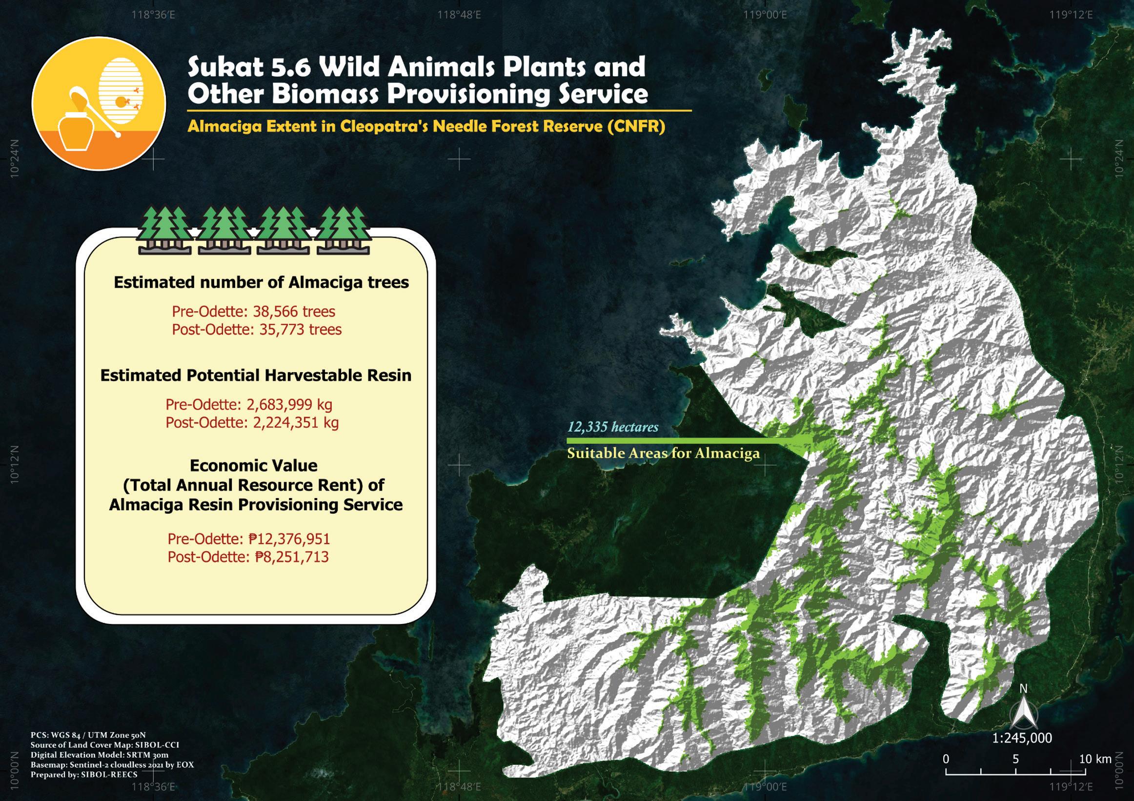
Figure 8. Pre- and post-Odette economic value of Almaciga resin provisioning service in CNFR based on the species’ spatial distribution and extent, the estimated number of trees, and estimated harvestable resin. At the Platinum level, total resource rent estimates are necessary outputs for justifying the presence of Sukat 5.6 in an area.
PUERTO PRINCESA SUBTERRANEAN RIVER NATIONAL PARK (PPSRNP)
In the world-famous underground river of Puerto Princesa, Sukat 2 was heavily impacted, as shown by the extensive decline in forest cover post-Odette (Figure 9). Closed forests and open forests were reduced to 70% (or 16,674 ha) and 30% (or 7,054 ha), respectively. As a result, suitable habitats of RTE species (Sukat 1) contracted and became fragmented (Figure 10). This compromised habitat connectivity of priority species across PPSRNP, which in turn, may affect the existing ecosystem services (Sukat 4 and 5) and cultural services (Sukat 6) present in the area. Global climate regulation services (Sukat 4.1) thus exhibited net GHG emissions equivalent to over PhP 10 billion with a significant reduction in value, using the social cost of carbon in monetizing the physical estimates (Figure 11). As such, total carbon stock was reduced between the opening (2021) and closing (2022) periods.
The forest ecosystems of PPSRNP are important sources of livelihood. This was demonstrated by estimating the contribution of forests to almaciga resin harvesting. The suitable habitats of almaciga trees showed that 16% of the total PA is important for this ecosystem service under Sukat 5 (Figure 12). As with CNFR, rent estimates, however, leave much to be desired, due to the lower farmgate prices of resin relative to other areas in Palawan.
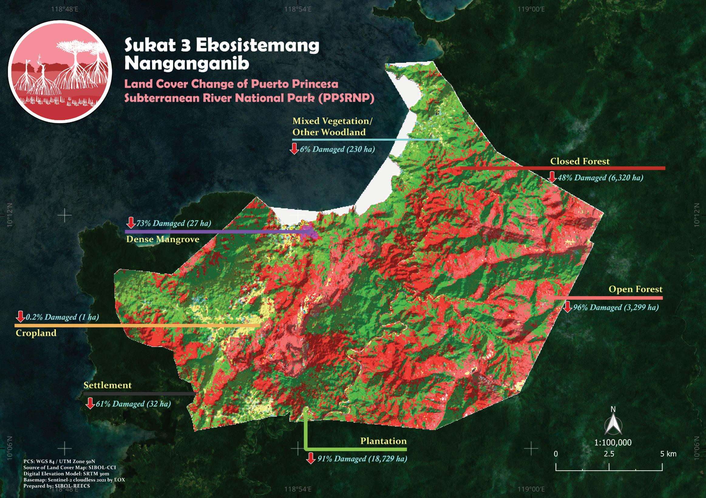
Figure 9. Map showing the land cover change in CNFR as a consequence of Typhoon Odette, using 2021 and 2022 land cover data. An ecosystem change map was used to determine the presence of Sukat 3.
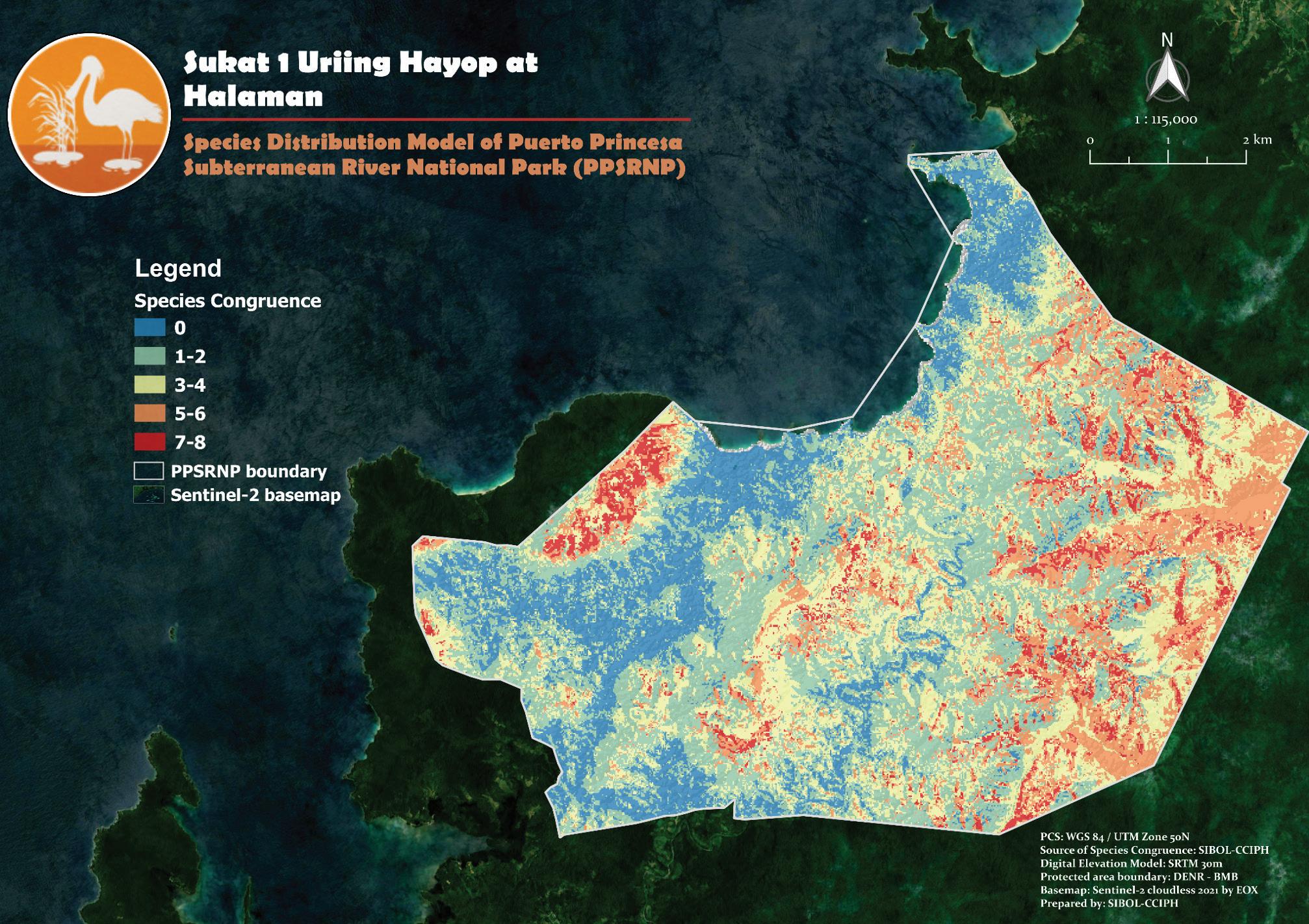
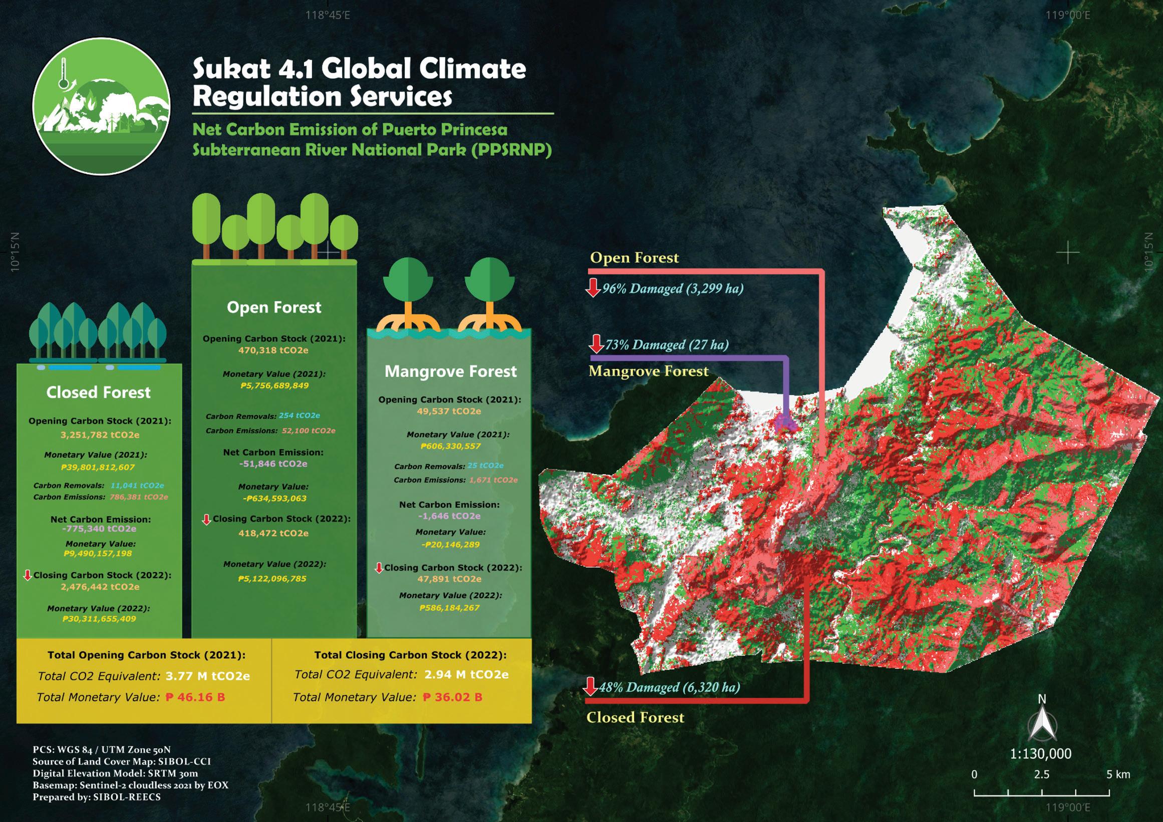
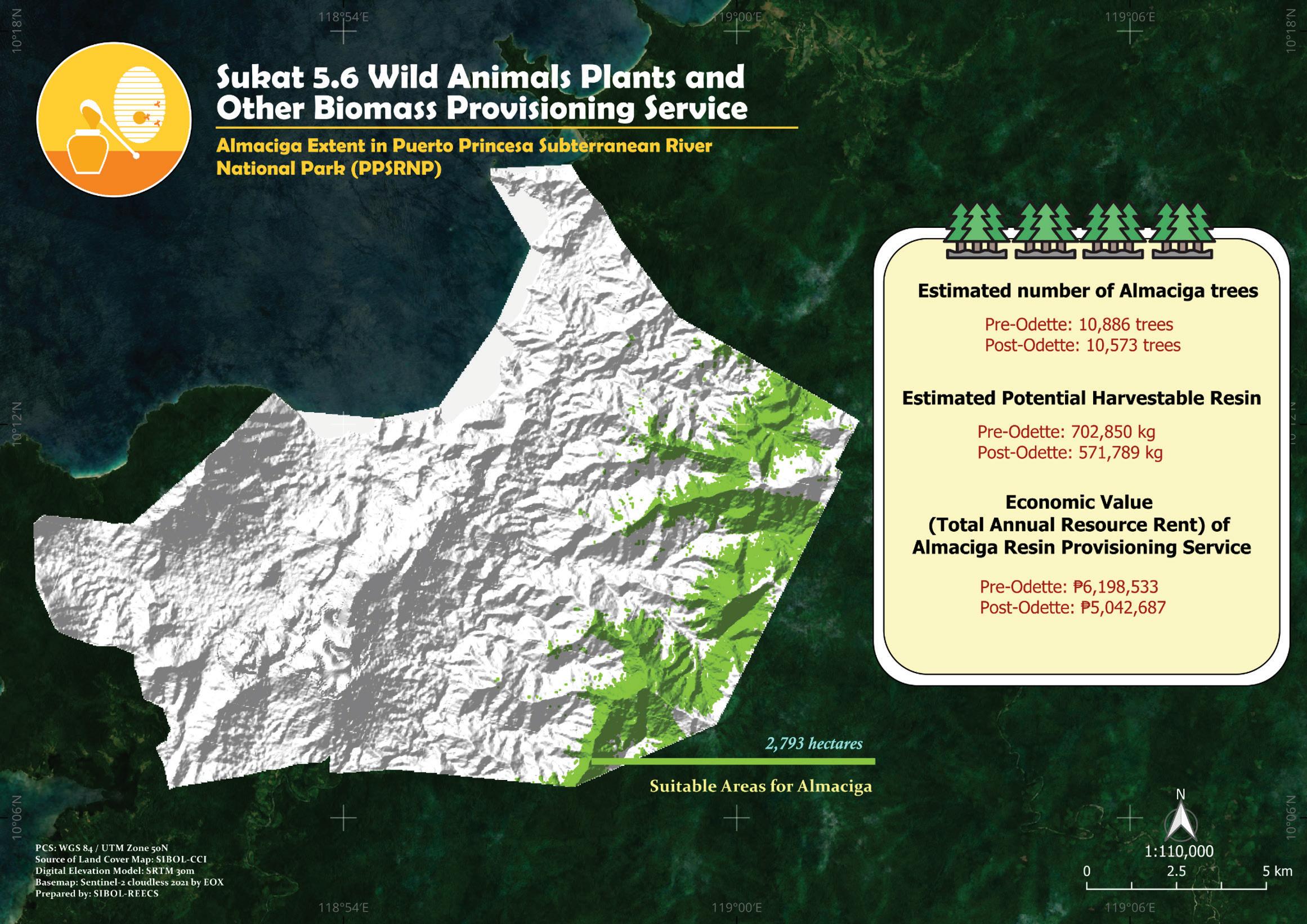
Figure 12. Spatial analysis showing the distribution of Almaciga, the extent of its ecosystem service (Sukat 5.6), and resource rent estimates in pre-Odette and post-Odette scenarios.
Looking at Sukat 6, recreational services had the highest contribution to the total cultural value. This was demonstrated by the high average and total values of the total recreational area, immediately after the impacts of COVID-19 and Odette (Figure 13). Residents of the park have their recreational activities conducted, translating to their average and total recreational values of the Park.
The massive deforestation post-Odette prompted the PAMB and LGU to implement the Green Recovery Plan (GRP), which was developed to restore damaged ecosystems that resulted from climate-induced disasters. The GRP adopts science-based techniques that are equally grounded in local settings. The success of the GRP hinges on two critical factors: science and people. Restoring the forests of PPSRNP and ensuring successful recolonization of species will necessitate the involvement of threatened and endemic frugivore species. These frugivores act as nature’s gardeners, catalyzing natural regeneration. Additionally, collaborative efforts that involve local communities and government agencies are essential to enhance recovery while safeguarding persistent ecosystems. By implementing sustainable almaciga resin harvest techniques and ecotourism guidelines, the GRP’s success is highly likely to positively impact the values for Sukat 1 to 6 in subsequent monitoring periods.
Figure 10. Post-Odette species congruence map of eight RTE species in PPSRNP.
Figure 11. Forest cover change and net GHG emissions in PPSRNP as a consequence thereof. Land cover change data (Sukat 3) is utilized to provide a quantification of total carbon stock from various carbon pools in the area (Sukat 4.1).
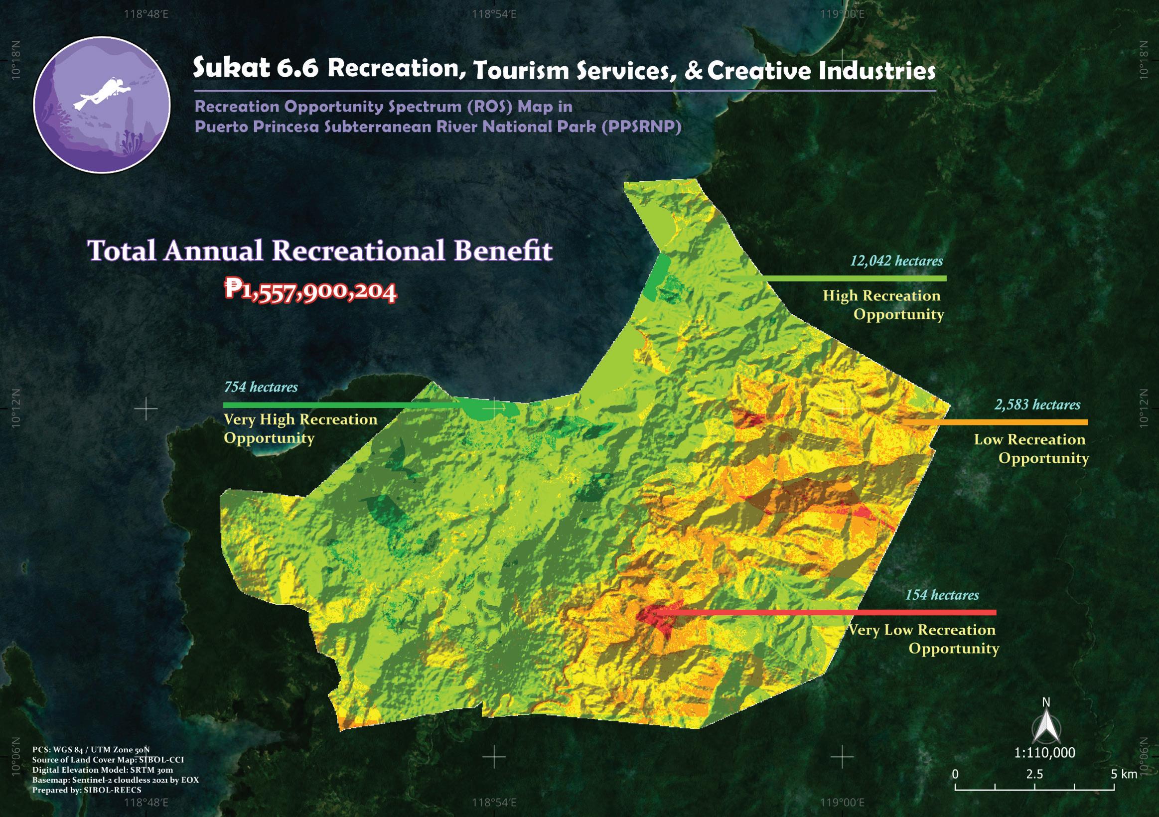
13. Map showing the recreation opportunity spectrum (ROS) in PPSRNP. Generating an ROS map is necessary for analyzing and interpreting Sukat 6. An output showing the economic value of recreational services from nature satisfies Sukat 6.6. Platinum level of standard.
MT. MANTALINGAHAN PROTECTED LANDSCAPE
(MMPL)
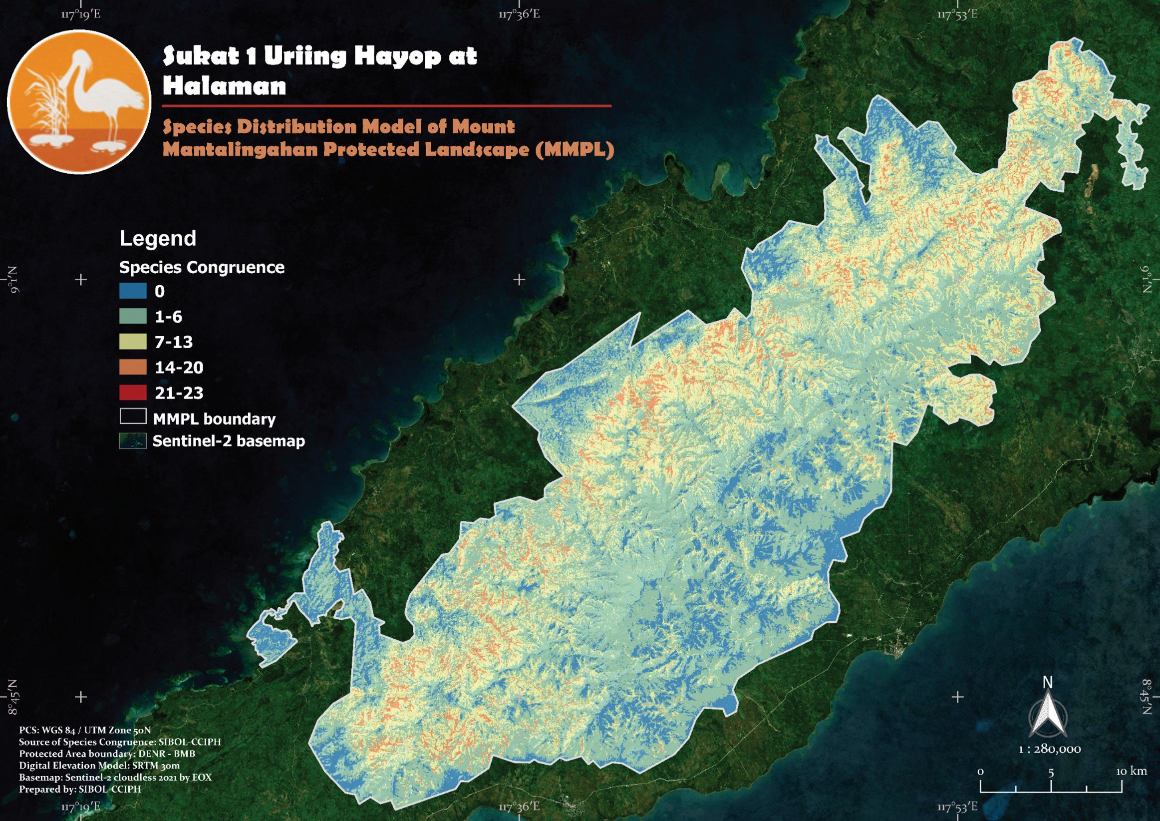
Our analysis for Sukat 1 revealed a significant contraction (loss) of suitable habitats due to the decline in both forest extent and quality during the last decade. RTE species are directly impacted by this decline, which is exacerbated by bushmeat hunting. For instance, our models suggest that the Palawan peacock-pheasant’s (Polyplectron napoleonis) spatial distribution shifted from commonly preferred lowland forests towards mid to higher elevation. Only a few small patches of highly suitable habitats remain (Figure 14). The predicted distribution highlights the urgent need for better-quality forests in lowland areas to ensure the long-term survival of this species.
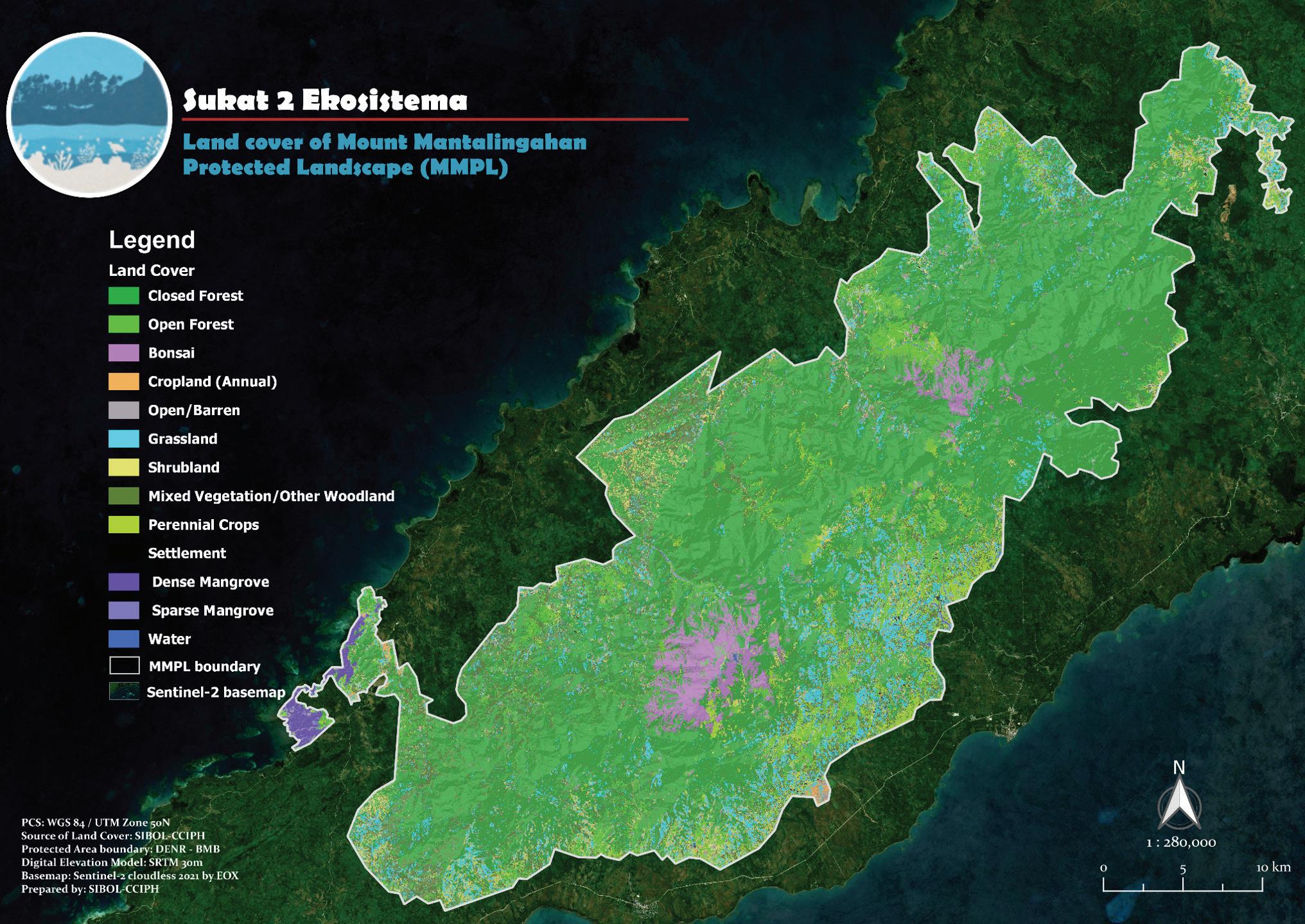
Estimating Sukat 2 (Figure 15) showed a downward trend in forest ecosystem extent over 10 years (Figure 16), despite recent efforts to assist management authorities in crafting their plans and strategies. Threats to deforestation can be gleaned from the contraction of forest ecosystems juxtaposed with the expansion of Kaingin (swidden agriculture) systems. This resulted in a downward trend in carbon stocks (Sukat 4), with emissions outweighing carbon removals (Figure 17). On the contrary, positive rent estimates (Sukat 5) were seen from almaciga resin harvesting in IP areas, coupled with positive rent estimates from timber harvesting activities (Figure 18). Crop farming is likewise practiced, with most crops exhibiting positive rent estimates (Figure 19).
It is not farfetched to attribute the negative trends and figures for Sukats 1 to 4 to some of the Sukat 5 elements, particularly timber harvesting and shifting cultivation practices. On the other hand, the results of Sukat 5 imply massive poverty among the residents of MMPL. If the drivers of deforestation are to be prevented, the poverty situation needs to be addressed immediately.
Figure
Figure 14. Map showing suitable habitats and spatial niche overlaps of 30 RTE species in MMPL.
Figure 15. Contemporary (2023) land cover of MMPL, with an overall accuracy assessment result of 97%. A multi-layer map of ecosystems having an accuracy above 90% is required for Sukat 1 at the Platinum level.
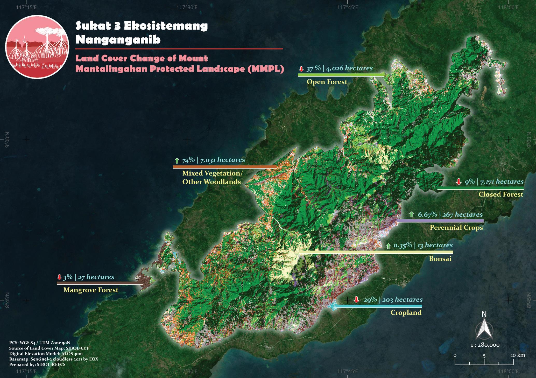
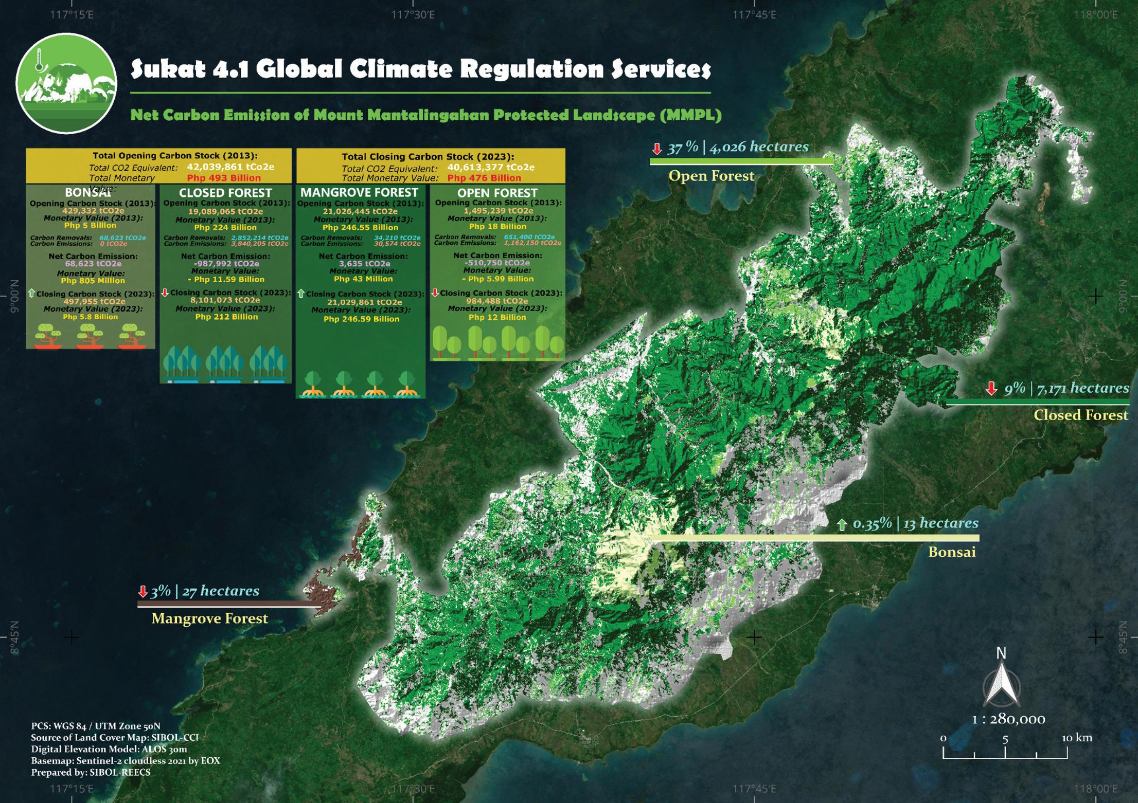
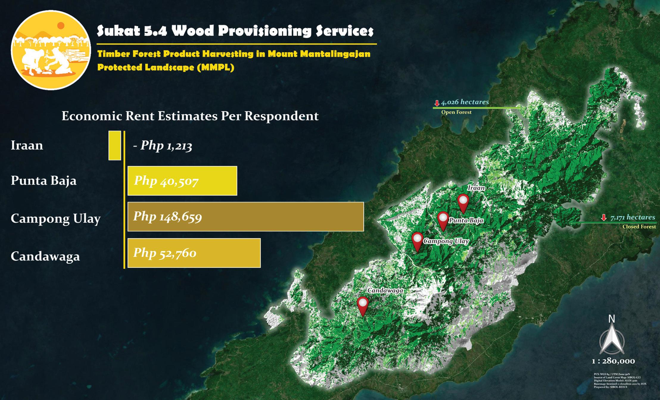
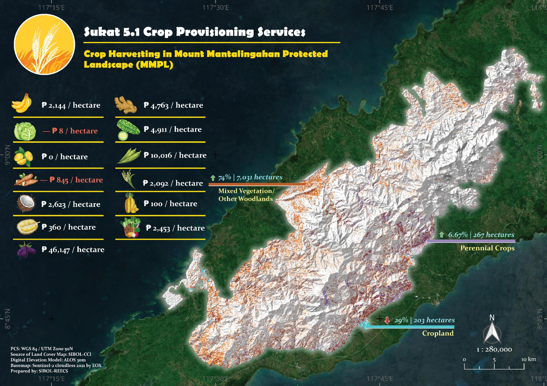
Figure 16. Land cover change in MMPL, using historical (2013) and contemporary (2023) land cover data.
Figure 17. Map showing the forest cover change (Sukat 3.2) and net carbon emissions in MMPL (Sukat 4.1).
Figure 18. Economic rent estimates from timber harvesting in MMPL. Resource rent estimates are required to satisfy the presence of Sukat 5.4 at the Platinum level.
Figure 19. Resource rent estimates from crop harvesting (per hectare) in MMPL. Resource rent estimates of crops being harvested in MMPL were computed to verify and quantify Sukat 5.1 at the Platinum level.
SIARGAO ISLAND PROTECTED LANDSCAPE AND SEASCAPE (SIPLAS)
The land cover change map of SIPLAS (Figure 20) shows a drastic reduction in open forests and croplands after Typhoon Odette. As a consequence, a significant shift of RTE species’ survival envelopes towards the now severely fragmented residual natural forest can be observed (Figure 21). Several RTE species are currently thriving in habitats with sub-optimal conditions within the mosaics of mixed vegetation across the main island particularly in Socorro.
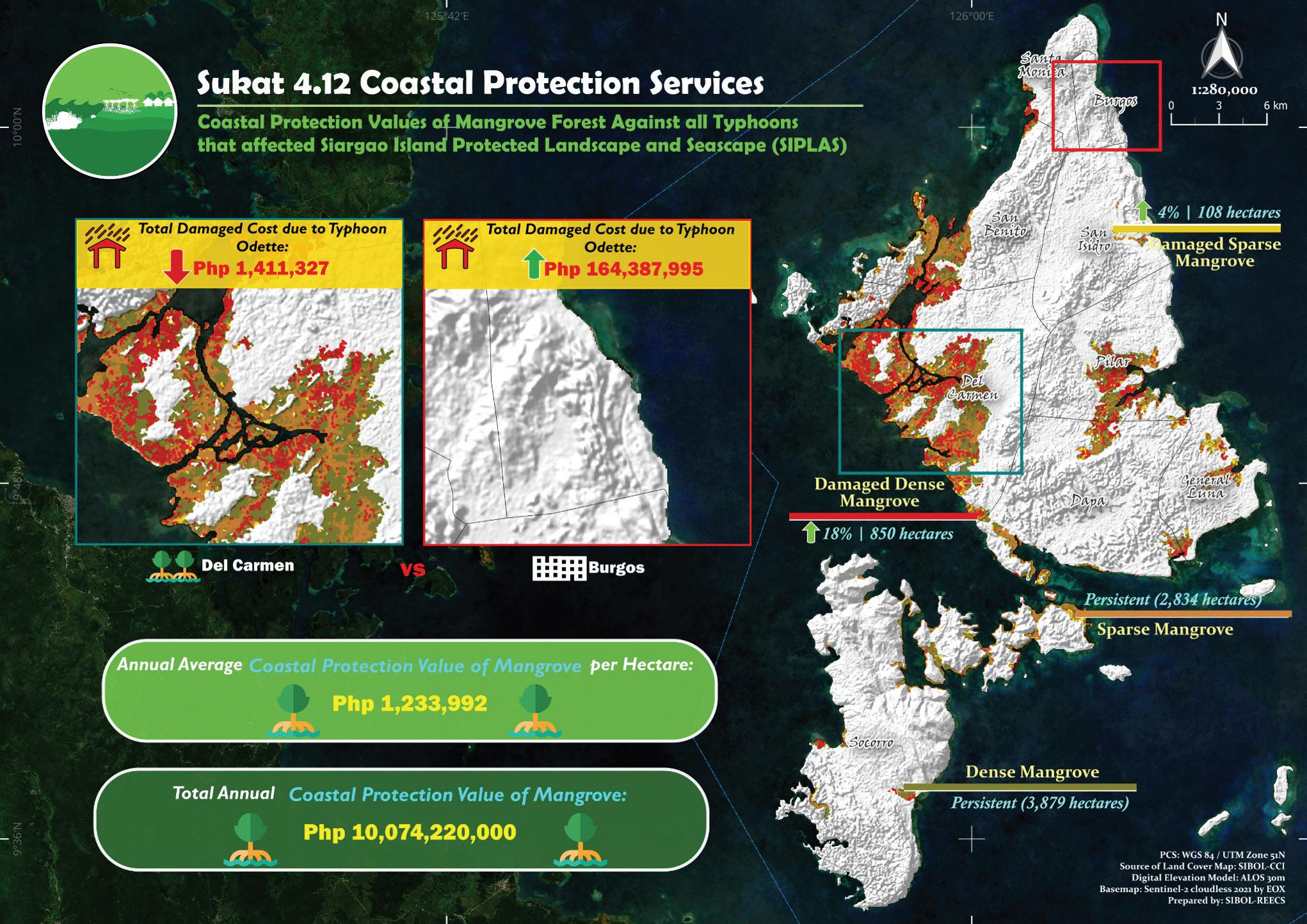
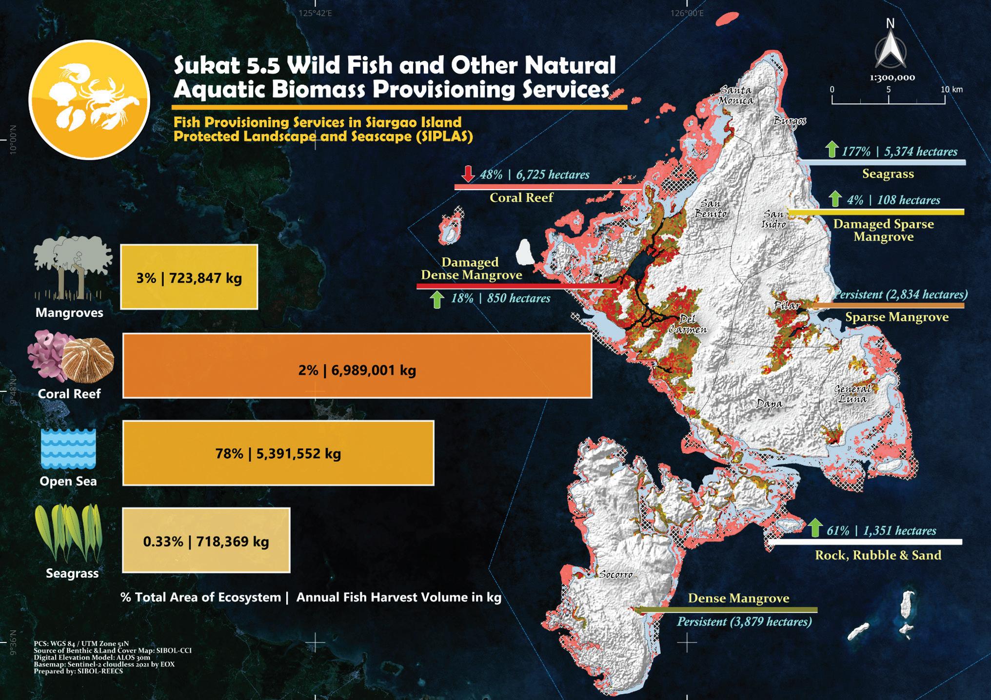
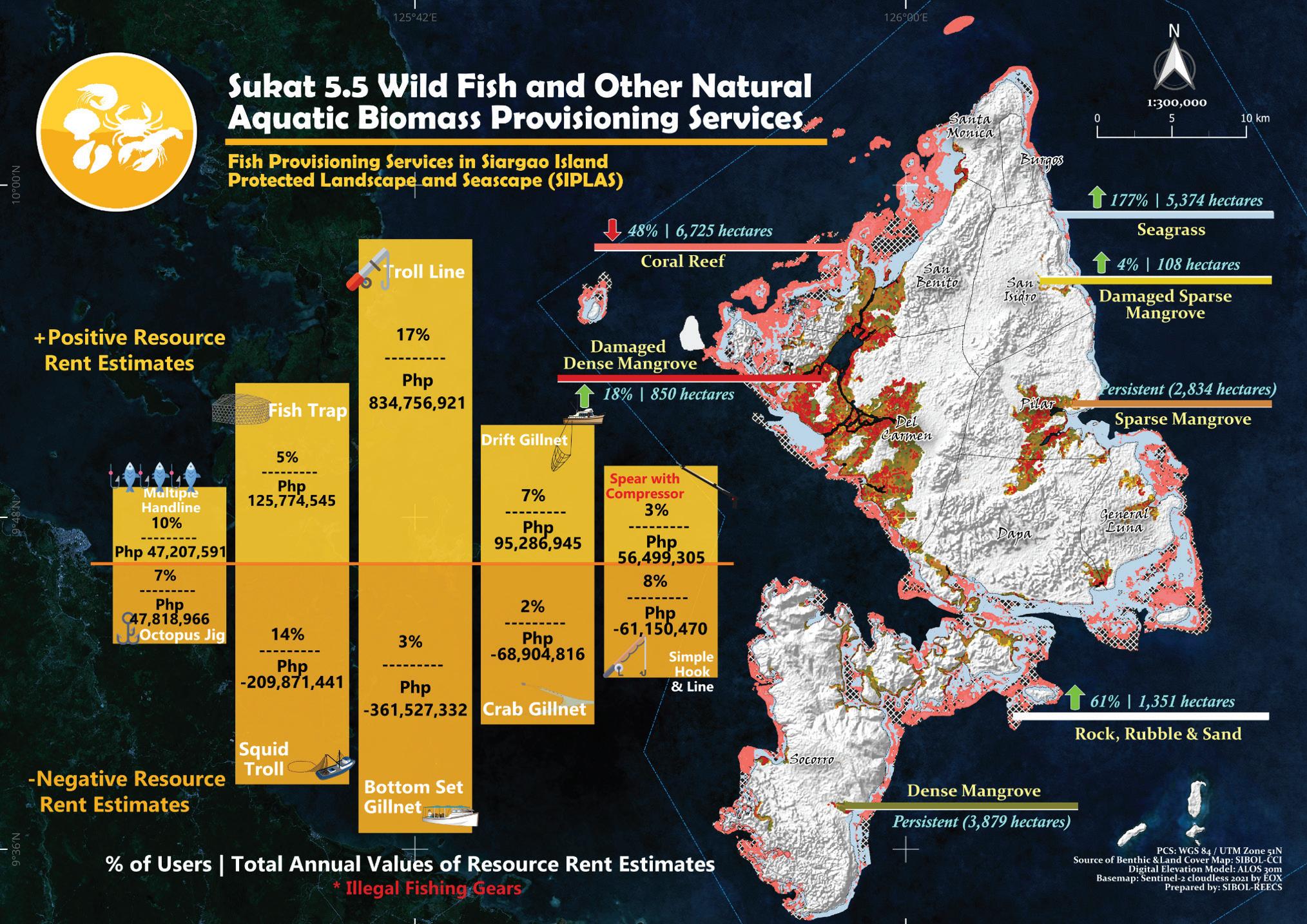
The low forest cover further translates to hardly any changes in net carbon emissions, in measuring global climate regulation services (Sukat 4.1) of forest ecosystems (Figure 22). On the other hand, the high mangrove cover provides an ecosystem service in the form of coastal protection (Sukat 4.12), with a highly significant economic value estimated at PhP 1.2 million pesos per hectare, per year, or a total of PhP 10 billion pesos per year for the whole PA (Figure 23). Maintaining a high mangrove cover provides one of the best nature-based solutions for improving resilience to forthcoming climate change impacts. When it comes to changes in benthic cover, the postOdette scenario showed a drastic reduction in coral reef extent, while mangroves and seagrass beds were more persistent. This may have tremendous impacts on ecosystem services in the next recording period, given the values of Fish Provisioning Services (Sukat 5.5). Coral reefs were recorded to contribute 51% to total fish provisioning, while seagrass beds and mangroves contributed 5% each. Rent estimates reveal positive contributions from most marine ecosystems, but negative estimates for seagrass beds may imply resource depletion and worse, ecosystem degradation (Figure 24). Top gears used in SIPLAS exhibited positive rent estimates (Figure 25). However, more types of gears had negative resource rent estimates, signaling overfishing and possible resource depletion.
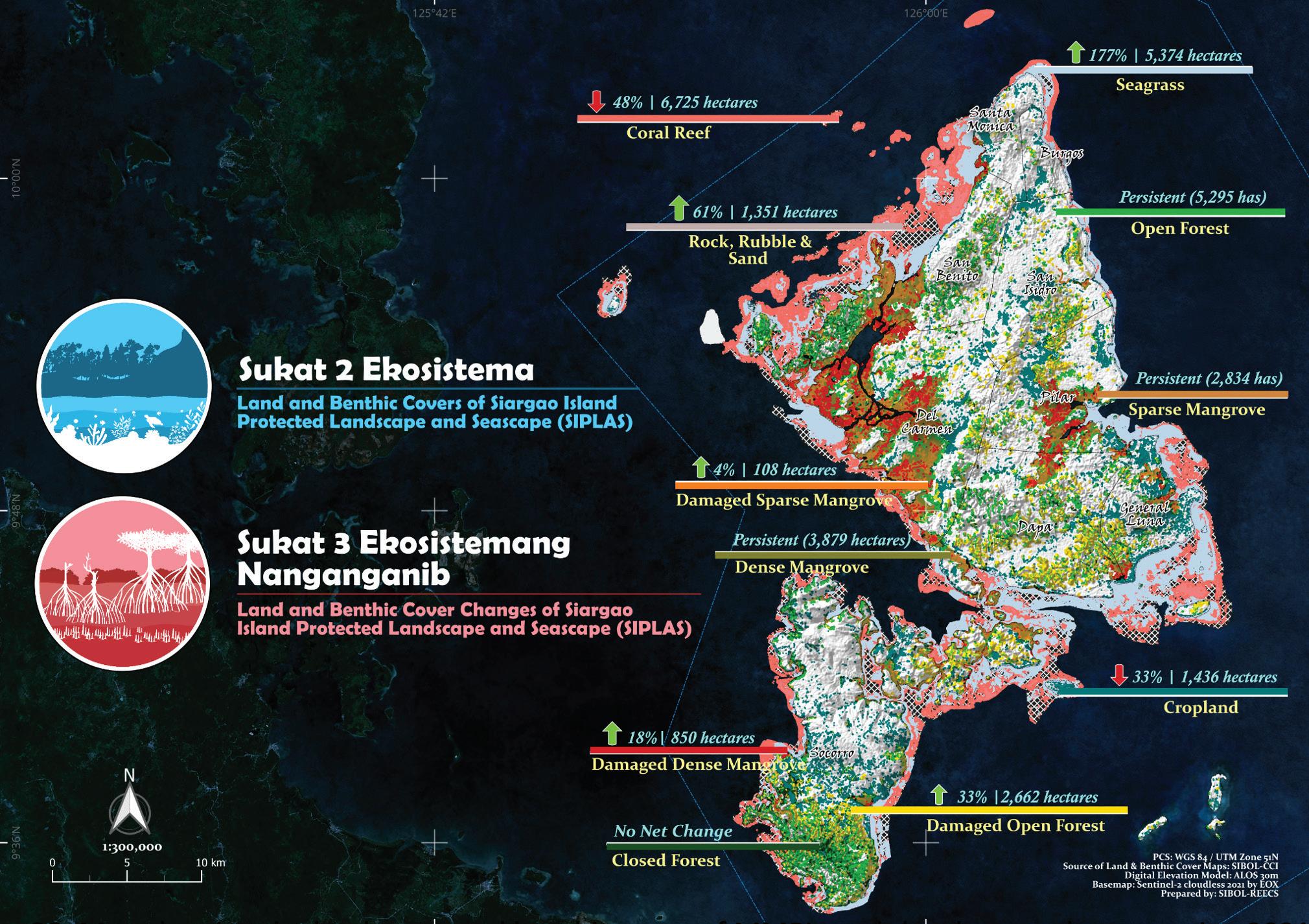
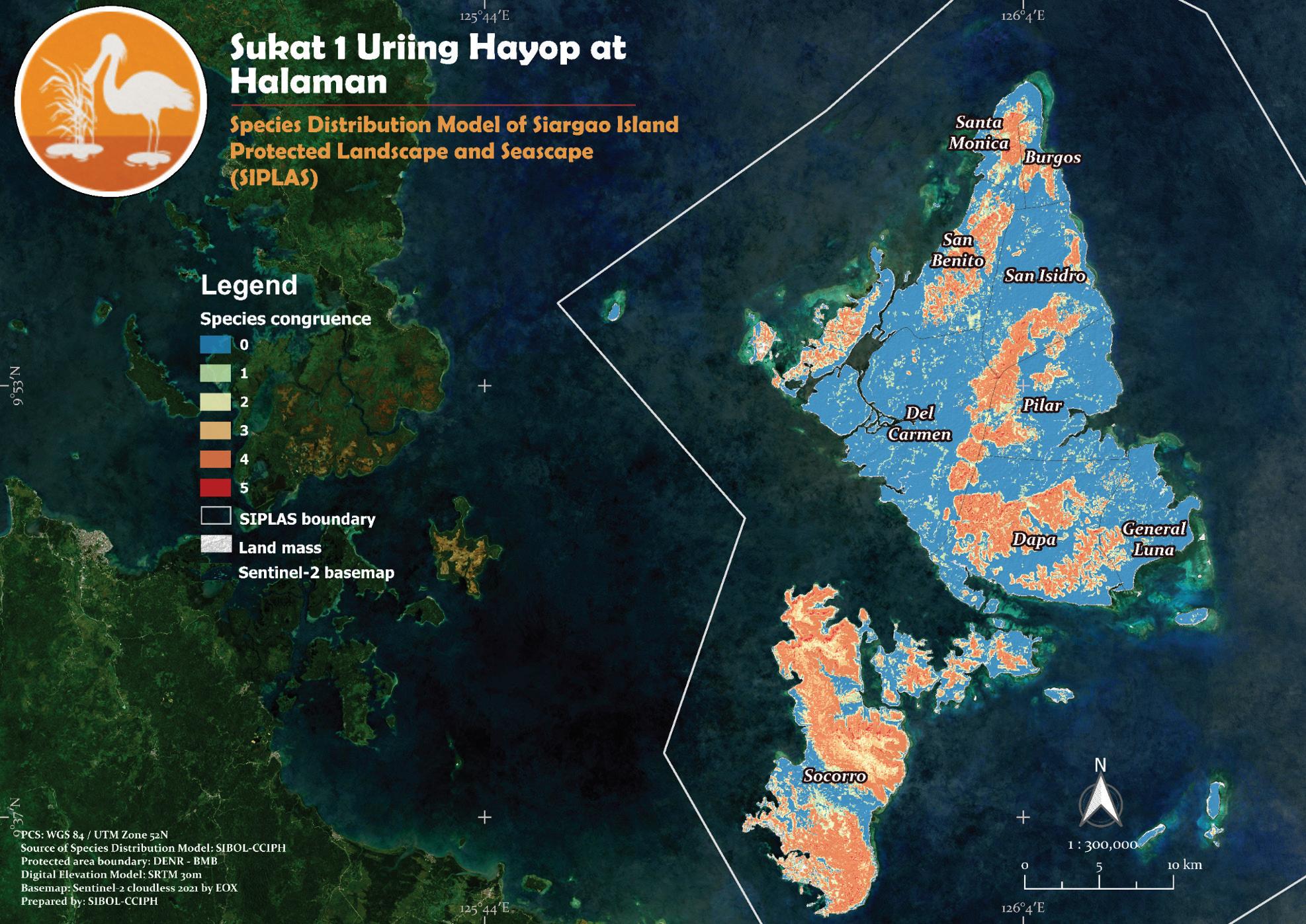
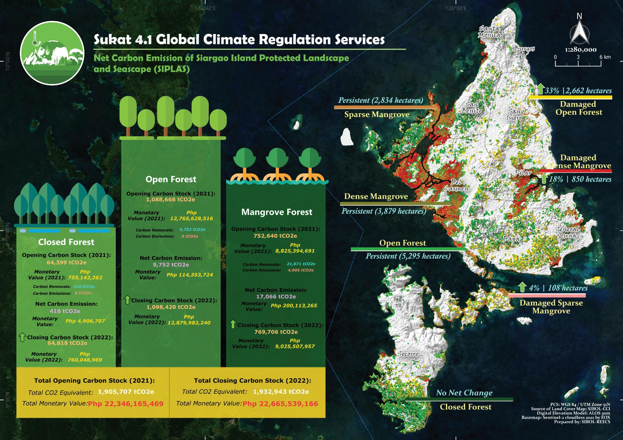
Figure 20. Map showing the land cover and benthic cover of MMPL, and the changes thereto, using 2021 and 2022 data.
Figure 21. Map showing suitable habitats and spatial niche overlaps of five RTE species in MMPL.
Figure 22. Net carbon emission estimates for global climate regulation services in SIPLAS.
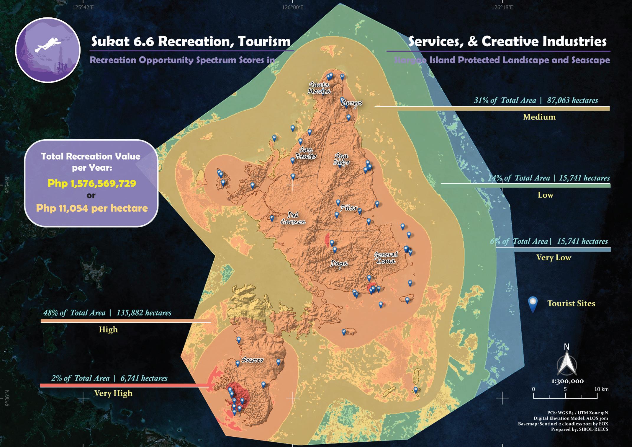
Estimates for recreational values (Sukat 6.6) are highly significant (Figure 26). Approximately 50% of the total area of the PA possesses high recreational potential, and this is further reflected in the high average and total values of this ecosystem service despite reeling from COVID-19 and Typhoon Odette. Even locals have a high positive recreational value attached to SIPLAS sites in the north, away from the usual tourist sites in the southern part of the island.
The increasing pressures from fishing and tourism, coupled with the decrease in forest and benthic covers, may cause undue pressure on these ecosystems. It is therefore important to monitor their conditions periodically and to juxtapose these monitoring results with the trends in physical and monetary values of ecosystem services to guide policy and decision-making. Values of ecosystem services for Sukats 5 and 6 may be increasing, but this might be to the detriment of Sukats 1 to 4 and the condition of the ecosystems in the long run. Lower quality and extent of ecosystems will lower the values of Sukats 5 and 6 in time. Awareness of these trade-offs will hopefully aid the decision-makers in coming up with more appropriate plans and programs in the future.
Figure 23. Coastal protection values of mangrove forests in SIPLAS. Estimation of the avoided damage costs under several typhoon scenarios is required output for Sukat 4.12 at the Platinum level.
Figure 24. Resource rent estimates for fish provisioning services in SIPLAS, per ecosystem type.
Figure 25. Resource rent estimates for fish provisioning services in SIPLAS, per gear.
RECOMMENDATIONS
The case studies presented showed evidence that many protected areas are in a state of active and advanced degradation. This downhill trend is further exacerbated by extreme weather events. Protected areas must now address this by adding a management zone: an ecological restoration zone. This will help guarantee eco-resilience via the long-term survival of species and sustained delivery of ecosystem services.
Sukat ng Kalikasan further suggests that the national government bureaucracy must now acquire sufficient capacity to develop and implement biodiversity and human well-being-centered management plans and programs of work using the SnK framework. Such capacity is needed to:
1. Generate baseline ecological data so that the status and trends of biodiversity and ecosystem services are understood and, therefore, appropriate biodiversity conservation targets and appropriate management programs of work are set, and measurable outcome indicators are identified;
2. Improve the PA planning process by drawing on analytical and scenario modeling methods to explore the outcomes of management decisions for species, ecosystems, and ecosystem services;
3. Mainstream natural capital into the larger economic development paradigm, influencing plans and programs, as well as budgets and public investments; and
4. Develop and implement a work program outside PA boundaries to address drivers of loss and degradation of the ecosystem and ecosystem services.

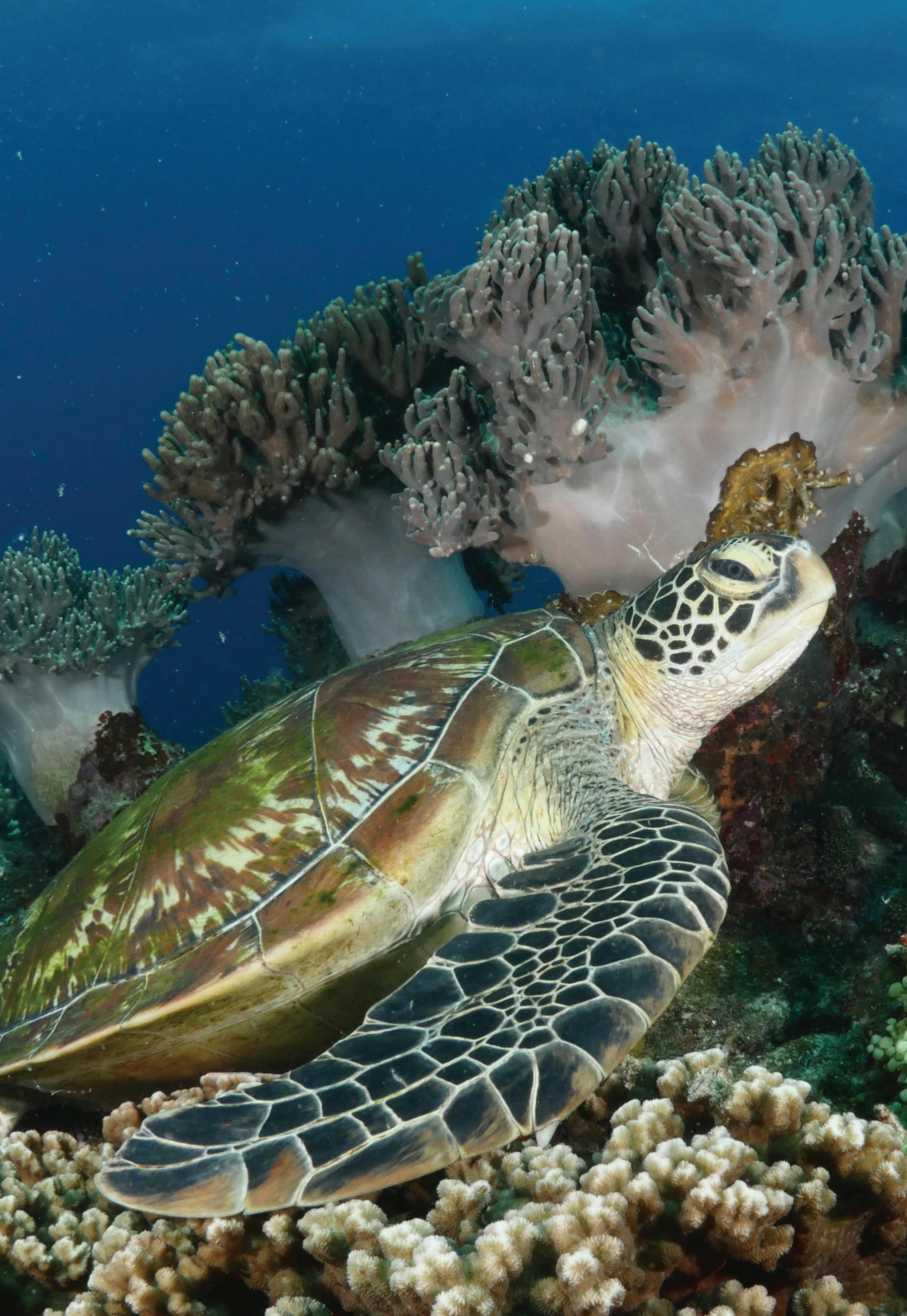
Figure 26. Recreation opportunity spectrum (ROS) scores in SIPLAS (Sukat 6).
Photos courtesy of Danny Ocampo