Heritage & Tall buildings

178 City Plan 2040 | Shaping the Future City
11

The City’s historic environment will be protected, celebrated and positively managed by:
1. Celebrating the City’s heritage for its contribution to the quality of life and promoting public enjoyment of, and access to, heritage assets;
2. Conserving and enhancing heritage assets and their settings; opportunities will be sought for development proposals to make a positive contribution to, and better reveal the significance of, heritage assets and reflect and enhance local character and distinctiveness;
3. Seeking wider social, cultural, economic and environmental benefits by:
a. placing heritage at the heart of placemaking and delivering high quality buildings and spaces which enrich and enhance the settings of heritage assets;
b. encouraging the beneficial, continued use of heritage assets through sensitive adaptation that is consistent with their conservation and enhancement, including those on Historic England’s Heritage at Risk Register;
c. encouraging heritage-led regeneration by identifying opportunities to draw on the contribution made by the historic environment to the character and identity of the place;
d. encouraging sensitive sustainable retrofit of designated as well as non-designated heritage assets and improvements that would benefit climate resilience and adaptation;
e. encouraging sites adjacent to and near heritage assets to work collaboratively with owners and operators of heritage assets to seek improvements to environmental performance, accessibility or other aspects of the functioning of heritage assets that are challenging to address;
f. Seeking enhanced public access and interpretation of the City’s cultural and heritage assets, ensuring that opportunities to experience and enjoy the City’s heritage and culture is available to a wide and diverse audience in a way that is socially and economically inclusive;
4. Protecting and promoting the assessment and evaluation of the City’s ancient monuments and archaeological remains and their settings, including the interpretation, archiving and publication of archaeological investigations; and
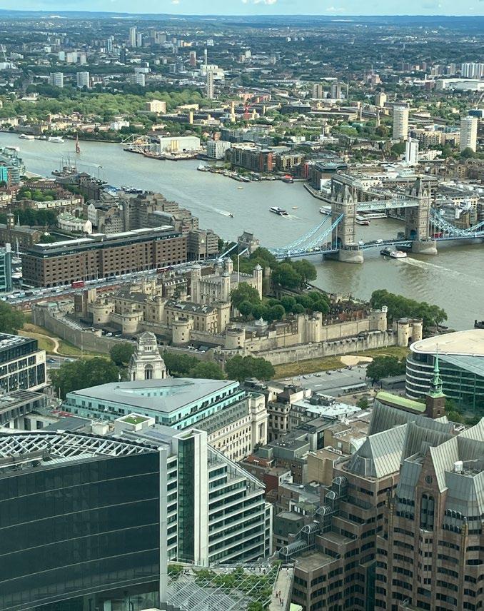
5. Preserving and seeking to enhance the Outstanding Universal Value (OUV), architectural and historic significance, authenticity and integrity of the Tower of London World Heritage Site and its setting.
Reason for the policy
11.1.0 The City of London is the historic centre of London and has a rich and varied historic environment that reflects this. The City’s heritage assets contribute to its unique identity, adding to its character, attractiveness and competitiveness. This is of benefit to all the City’s communities, workers, residents and visitors.
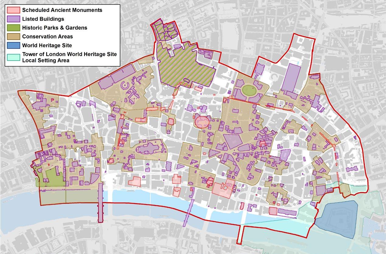
11.1.1 There are a large number of designated heritage assets in the City, with over 600 listed buildings and many structures such as statues, monuments and sculptures. Listed buildings range from a 17th century home on Cloth Fair, the unique early 18th century Bevis Marks Synagogue, and Wren’s iconic St Paul’s Cathedral and churches, to modern buildings by renowned architects, such as the Barbican Estate and the Lloyds Building. As well as listed buildings there are 27 conservation areas, 48 scheduled monuments and five historic parks and gardens. Furthermore, the City provides part of the backdrop and setting for the Tower of London World Heritage Site.
11.1.2 The City has a rich archaeological heritage including many designated and non-designated monuments visible in the townscape and surviving as buried remains below buildings and streets. The whole of the City is regarded as having archaeological potential.
11.1.3 The City contains a rich variety of architectural styles and materials, a medieval street pattern and a long history as a centre for commerce and trade. The diversity of the buildings and townscape creates a rich juxtaposition between the historic and the modern. This and the dense nature of development helps to differentiate the
City of London from other global commercial centres and makes the City a unique place to live, work and visit.
11.1.4 The City’s rich heritage contributes to the City’s primary function as a business centre, its cultural role, as a home to its small resident population and increasingly its role as a visitor destination. Approximately two thirds of the City’s listed buildings have a commercial use, including offices, retail, and hotels and provide vital small and medium-sized office space.
11.1.5 Heritage assets can significantly contribute to London’s economy, providing valuable office space suitable for small to medium-sized occupants as well as creative industries, and providing potential space for hotels and retail uses. In order to build upon the wider social, cultural and economic benefits of the historic environment, public access to, and experience of, the City’s heritage will be sought as part of development proposals in line with the wider policies in this Plan.
11.1.6 The re-use, refurbishment and retrofitting of the City’s historic building stock is important for mitigating climate change impacts and reducing carbon emissions. Heritage assets must adapt to meet changing needs and environments while preserving their heritage significance. The City Corporation will require development proposals to find sensitive retrofitting solutions to reduce carbon emissions; enhance climate resilience; and improve access and environmental performance of historic buildings. Retrofitting historic buildings will be supported where a sensitive and tailored approach to design and specification is taken, in line with the City Corporation’s Heritage Buildings Retrofit Toolkit.
11.1.7 Applicants will be required to undertake a comprehensive heritage assessment proportionate to the scale of their site and heritage asset to understand ways in which their proposal could contribute towards the enhancement and enjoyment of the historic environment. This should include considering innovative approaches that extend beyond conventional conservation practices to promote wider social, cultural and environmental benefits associated with heritage conservation.
Development proposals that affect heritage assets or their settings should be supported by a Statement of Heritage Significance and a Heritage Impact Assessment. It should be ensured any impacts of the proposals on the significance of heritage assets or their settings have been fully assessed and understood. The level of detail should be proportionate to the assets’ importance and no more than is sufficient to understand the potential impact of the proposal on their significance.
Proposals should meet the following criteria:
1. Development should preserve and where possible enhance and better reveal the special architectural or historic interest and the significance of heritage assets and their settings;
2. There will be a presumption against heritage harm and development causing harm to, or total loss of, the significance of designated heritage assets will be refused unless it is clearly demonstrated that the heritage and/or wider public benefits outweigh that harm or loss. Applicants should clearly demonstrate that all reasonable efforts have been made to sustain the existing use, find new appropriate uses, or mitigate the extent of the harm to the significance of the asset; and whether the works proposed are the minimum required to secure the long-term use of the asset;
3. Change of use to heritage assets should be consistent with their long-term conservation and should help to retain and enhance the asset, particularly those which have been identified at risk;
4. Development should not cause the loss of routes and spaces that contribute to the character and historic interest of the City. The reinstatement of historic routes and the creation of new routes will be sought;
5. Where proposals would result in harm to, or the loss of, a nondesignated heritage asset, the City Corporation will have regard to the scale of any harm or loss, the significance of the heritage asset and the wider public benefits proposed;
6. Development in conservation areas should preserve, and where possible, enhance and better reveal the character, appearance and significance of the conservation area and its setting. The buildings and features that contribute to the character, appearance, setting or significance of a conservation area should be conserved and opportunities to enhance conservation areas should be considered;
7. Development should preserve, and where possible, enhance and better reveal the significance, character and appearance of the City’s registered historic parks, gardens and open spaces and should protect their settings and views from and towards these spaces;
8. Development in the defined immediate setting of Bevis Marks
Synagogue and The Monument should preserve, and where possible, enhance the elements of setting that contribute to the significance of these heritage assets; and,
9. Development should encourage the appreciation of the City’s historic roofscapes and should not impact the setting of an asset from highlevel locations.
11.2.0 The City of London’s historic environment is of one its greatest assets. The special character that the City derives in large part is from the concentration and significance of its heritage assets, many of which are nationally and internationally renowned. Given their immense contribution to the character, economy and quality of life of the City, it is important that change to the historic environment is sensitively and carefully managed in ways appropriate to its significance and that makes it an integral part of the surrounding context.
11.2.1 The City Corporation has identified ‘immediate setting’ areas around the Monument and Bevis Marks Synagogue, both of which are Grade I listed heritage assets in the City and require special consideration and protection, given their outstanding architectural and historic significance and, for these particular buildings, the critical contribution of elements of setting to that significance.
11.2.2 Applicants should provide a clear and comprehensive understanding of the heritage significance of a building including any contribution made by their setting. The level of detail should be proportionate to the nature and scale of the proposed development. This may require detailed archival research to understand the historical evolution of the building in order to inform the proposals as well as the impact of the development on the heritage asset.
11.2.3 National policy applies different tests to development proposals that would result in substantial harm to (or total loss of) the significance of a designated heritage asset and proposals that would cause less than substantial harm. Where the harm is less than substantial, it should be weighed against the public benefits of the proposal including, where appropriate, securing its optimum viable use. National policy indicates that great weight should be given to the asset’s conservation and the more important the asset, the greater the weight should be. This is irrespective of whether any potential harm amounts to substantial harm, total loss or less than substantial harm to its significance.
11.2.4 Where a development proposal would affect a non-designated heritage asset, national policy requires a balanced judgement to be made having regard to the scale of harm and the significance of the asset. The City Corporation will aim to identify nondesignated heritage assets at the earliest stage in the planning process, with reference to current national criteria. This may be supported by additional research or investigations as appropriate and be based on a clear understanding of the building, structure, open space or archaeological remains, including group value.
11.2.5 The designation of conservation areas carries with it the statutory duty to consider how an area or areas can be preserved and enhanced. The City Corporation will take the opportunity presented by development proposals within a conservation area to strengthen the special character of that conservation area and its setting. Applicants should consider the significance
and special character of conservation areas, informed by the Character Summary and Management Strategy Supplementary Planning Documents.
11.2.6 In the design of new buildings or the alteration of existing buildings, developers should have regard to the character of conservation areas and their settings. This includes the size and shape of historic building plots, existing street patterns and the alignment and the width of frontages, materials, vertical and horizontal emphasis, layout and detailed design, bulk and scale, including the effects of site amalgamation on scale, and hard and soft landscaping. Regard should be paid to the richness, variety and complexity of the architectural form and detailing of buildings and to the broader character of the area.
11.2.7 Many buildings in conservation areas, make a significant contribution to the character of these areas. Proposals for the demolition of a non-listed building will be considered in terms of the building’s significance, its contribution to the character or appearance of the area and the level of potential harm.
11.2.8 Even minor changes to listed buildings can have a significant impact on their character and appearance. Listing descriptions are unlikely to refer to every feature of significance and buildings’ interiors and plan forms are also of importance. Inspections of listed buildings will be necessary to identify the special interest and significance of the building and its curtilage.
11.2.9 Extensions to listed buildings should be of an appropriate scale and character and will be acceptable where the overall impact on the building does not harm its significance. The bulk, height, location and materials of roof extensions will be particularly important and should be appropriate to the period and style of the building and its setting. Where listed buildings are no longer used for their original or previous purpose, it is important to find alternative uses that safeguard their future, while being compatible with the character of the building.
11.2.10 The pattern of streets, lanes, alleyways and other open spaces, such as squares and courts, is a distinctive element of the City’s townscape and is of historic significance in itself. The City Corporation will seek to maintain the widths and alignments of streets, lanes and other spaces where these have historic value or underpin the character of a location or their surroundings. Some historic routes have been lost to the detriment of the City’s historic townscape. Where possible, the City Corporation will seek to re-open or reintroduce such routes when the opportunity arises.
11.2.11 In the design of new buildings or the alteration of existing buildings, developers should have regard to the character of conservation areas and their settings. This includes the size and shape of historic building plots, existing street patterns and the alignment and the width of frontages, materials, vertical and horizontal emphasis, layout and detailed design, bulk and scale, including the effects of site amalgamation on scale, and hard and soft landscaping. Regard should be paid to the richness, variety and complexity of the architectural form and detailing of buildings and to the broader character of the area.
11.2.12 Applicants will be required to provide supporting information describing the significance of any heritage assets where fabric or setting would be affected, along with the contribution made by their setting to their significance and the potential impact of the proposed development on that significance. A heritage asset’s significance can be evidential, historic, aesthetic or communal. The information provided should be proportionate to the level of change or impact a proposal will have on the heritage asset or assets. Applicants should refer to guidance by Historic England, Good Practice Advice Note in Planning 3: The Setting of Heritage Assets.
11.2.13 The City Corporation’s Character Areas Study provides an overview of the City’s overall significance including a Statement of Significance for key strategic assets, like St Paul’s Cathedral; The Monument; and the Tower of London. It identifies the principle attributes that contribute to the significance of these heritage assets and their settings, which should be protected, enhanced, better revealed or celebrated. The study also divides the City into nine character areas having shared characteristics, and provides a thorough assessment of the core heritage typologies in these areas, highlighting the key aspects that contribute to their significance. Applicants should draw reference to the Character Areas Study to understand their site’s significance and the key attributes of significance that they should consider.
1. The City Corporation will preserve, protect, safeguard and enhance archaeological monuments, remains and their settings, seeking enhancement, inclusive access to, public display and interpretation where appropriate.
2. Development proposals which involve excavation or works affecting sites of archaeological potential must be accompanied by an archaeological assessment and evaluation of the site, addressing the impact of the proposed development, mitigation of harm and identification of enhancement opportunities.
3. Significant, substantive archaeological features on major development sites must be preserved in-situ and, where feasible, exposed to public view. Significant archaeological artefacts on major development sites must be retained and exhibited on site. Where it can be demonstrated that found archaeological features or artefacts are of lesser significance or substance, proper investigation and recording of archaeological remains will be required as an integral part of a development programme, including timely publication and archiving of results to advance understanding.
Reason for the policy
11.3.0 The archaeological potential of the City is of national and international significance and continues to shed new light on the Roman world in Britain, as well as considerable detail of life in later periods. Although there has been considerable redevelopment and excavation within the City, there remains much potential for the City’s archaeology to reveal information about and deep understanding of period in its history spanning two thousand years. Some of the archaeology is still visible – such as the remains of the Roman and medieval City wall exposed above ground or revealed in development sites, or the remains of the Amphitheatre below the Guildhall.
11.3.1 The City’s rich archaeological heritage has a major role to play in the Destination City programme and a strong contribution to make to the City’s cultural offer. Accordingly, the City will, whilst adhering to the highest standards of scholarly research, investigation and recording, proactively seek opportunities to reveal and celebrate this archaeological heritage.
How the policy works
11.3.2 The City Corporation will indicate the potential of a site, its significance and relative importance and the likely impact on archaeology at an early stage so that the appropriate assessment, evaluation and design development can be undertaken.
11.3.3 Planning applications that involve excavation or ground works must be accompanied by an archaeological assessment and evaluation of the site, including the impact of the proposed development. An evaluation should include trial work in agreed specific areas of the site to provide more information and to inform consideration of the development proposals by the City Corporation.
11.3.4 In some cases, a development may reveal archaeological features or artefacts which could either be displayed on the site, or reburied. Their treatment would depend on their level of significance and their substantiveness.
11.3.5 Undesignated archaeological features equivalent in significance and substance to a scheduled ancient monument will be treated accordingly following consultation with Historic England.
11.3.6 On sites where significant, substantial archaeological features exist, development must be designed to enhance physical preservation and avoid disturbance or loss. This can be done by the sympathetic design of basements, raising ground levels, site coverage, and the location of foundations to avoid or minimise archaeological loss and securing their preservation for the future.
11.3.7 The interpretation and presentation to the public of a visible or buried monument and enhancement of its setting should form part of development proposals and agreement will be sought, where appropriate, to achieve public access. Successful exemplars of this are the Roman Wall exhibition at Vine Street, the Roman amphitheatre in the Guildhall Art Gallery or the Temple of Mithras at Bloomberg.
11.3.8 On sites where significant archaeological artefacts are discovered, there would be a presumption to retain them on site and display them in the most optimal place for appreciation by the public. This would be undertaken following the conclusion of any programme of research and study.
11.3.9 Development proposals should provide an adequate assessment of a site and make any provision for the incorporation, safeguarding or preservation of significant features or remains, or which would harm or adversely affect those features or remains. Where display features or of archaeological remains would harm the heritage asset or make it vulnerable and reburial is necessary, there should be interpretation to widen knowledge and contribute to the interest of the townscape.
11.3.10 A programme of archaeological work for investigation, excavation and recording and publication of the results to a predetermined research framework and by an approved organisation should be submitted to and approved by the City Corporation, prior to development. This will be conditioned and will ensure the preservation of those remains by record. The programme of archaeological work should include all on-site work, including details of any temporary works which may have an impact on the archaeology of the site and all off-site work including the postexcavation analysis, publication and archiving of the results.
1. Development proposals affecting the setting of the Tower of London World Heritage Site should preserve and seek to enhance the Outstanding Universal Value (OUV), architectural and historic significance, authenticity and integrity of the Tower of London World Heritage Site. Applicants will be required to submit a Heritage Impact Assessment along with the planning application.
2. Development proposals within the defined Local Setting Area of the Tower of London World Heritage Site should seek opportunities to enhance the immediate surroundings of the World Heritage Site, through improvements to the public realm and connectivity.
3. Development proposals in the vicinity of the Tower of London World Heritage Site will be encouraged to enhance pedestrian and cycle routes, including signage and wayfinding in the area that is appropriate and contributes to the importance of setting of the Tower by improving its public accessibility and visibility.
Reason for the policy
11.4.0 The Tower of London is a UNESCO World Heritage Site of Outstanding Universal Value. While the Tower itself is within the London Borough of Tower Hamlets, part of the defined Local Setting Area is within the City and is shown on the Policies Map. The local setting of the Tower comprises the spaces from which it can be seen from street and river level, and the buildings that enclose or provide definition to those spaces. The area around the Tower includes some streets with heavy traffic flows, and there is scope for improvements to be made to the public realm and to safety and accessibility for people walking and cycling.
How the policy works
11.4.1 Any potential impacts on the setting of the Tower of London World Heritage Site need to be considered in the relevant documents accompanying planning applications, such as in Heritage Statements, Townscape and Visual Impact Assessments or Transport Assessments.
11.4.2 The Tower of London World Heritage Site Management Plan 2016, the Mayor of London Supplementary Planning Guidance ‘World Heritage Sites – Guidance and Settings 2012’ and the Tower of London ‘Local Setting Study 2010’, provide guidance on how the setting of the World Heritage Site can be positively managed, protecting its OUV, while accommodating change.
The International Council on Monuments and Sites (ICOMOS) publication ‘Guidance on Heritage Impact Assessments for Cultural World Heritage Properties’ offers guidance on the process of commissioning Heritage Impact Assessments (HIAs) for World Heritage properties and also outlines the methodology to be used to evaluate the impact of potential development on the OUV of properties.
11.4.3 The Character Areas Study contains a Statement of Heritage Significance for the Tower of London outlining the key attributes that contribute to the OUV of the Tower of London and its setting which should be protected, enhanced or better revealed. Applicants should refer to the Statement of Heritage Significance to fully understand the significance of the Tower of London and its setting.
11.4.4 The City Corporation is also undertaking a Heritage Impact Assessment to assess the potential impacts of the tall building areas on the OUV of the Tower of London WHS.
Definition
1. Tall buildings within the City of London are defined as buildings over 75m above Ordnance Datum (AOD).
Location and heights
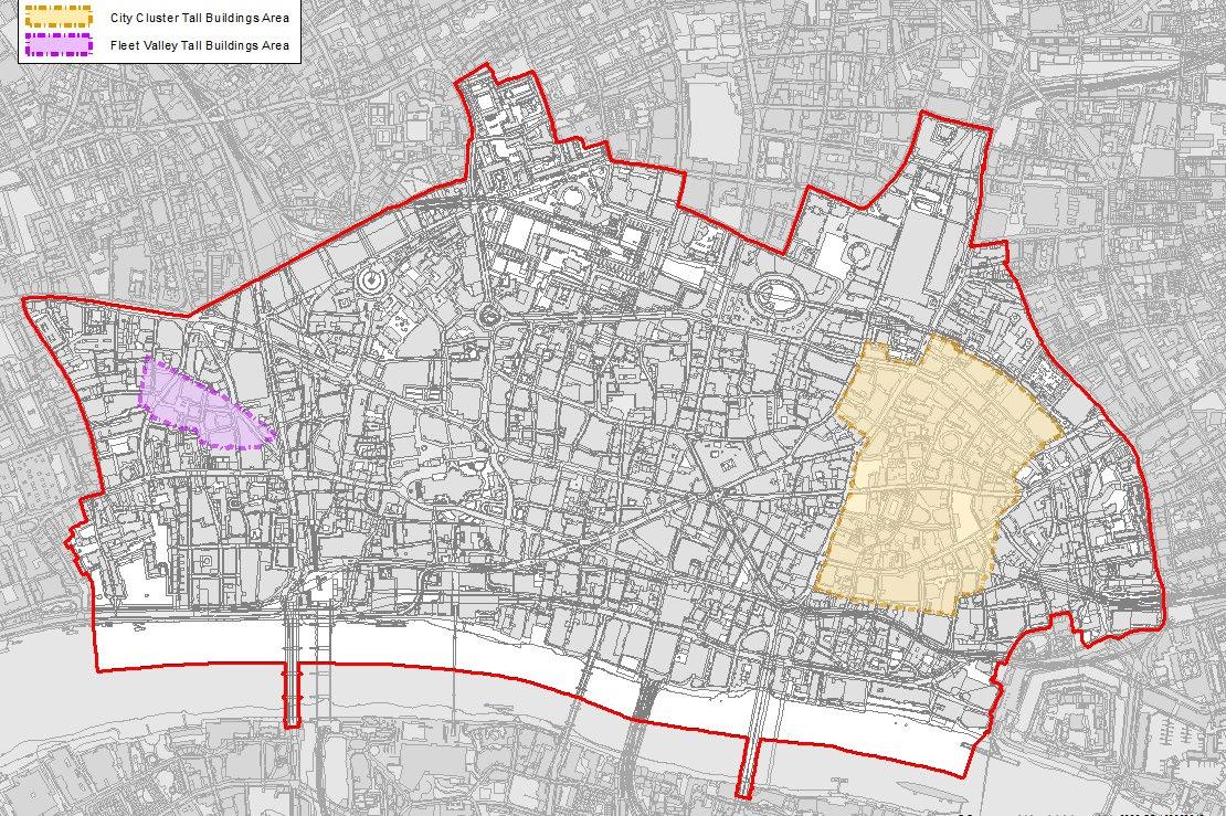
2. The tall building areas identified on the Policies Map and Figure 14 are areas where tall buildings may be appropriate, subject to the requirements in this and other relevant policies.
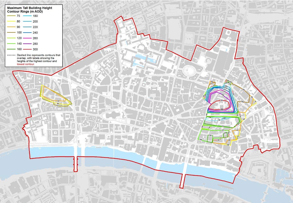
3. The maximum permissible tall building heights within the identified tall building areas are depicted as contour rings on Policies Maps C and D and Figure 15. Tall buildings should not exceed the height of the relevant contour rings. In areas between the contour rings, tall buildings should be designed to successfully mediate between the contour ring heights and should not exceed the next higher contour. Tall buildings should not necessarily be designed to maximise height; instead they should be thoughtfully designed to create built form that contributes positively to the skyline and townscape character, creating a coherent cluster form and a varied and animated skyline, and should have architectural integrity.
4. The height and form of tall buildings must take account of strategic and local views.
5. The suitability of sites for tall buildings within the identified areas and their design, height, scale and massing should take into consideration local heritage assets and other localised factors relating to townscape character and microclimate.
6. Applicants will be required to submit accurate three-dimensional computer models to support the analysis of their proposals. Accurate Visual Representations (AVRs) should be submitted as part of the application.
7. Applicants will be required to ensure that any cross-boundary impacts of proposed schemes are fully addressed.
8. Tall buildings must have regard to:
a. the potential effect on the City skyline, the wider London skyline and historic skyline features;
b. the character and amenity of their surroundings, including the relationship with existing and consented tall buildings;
c. the significance of heritage assets and their immediate and wider settings;
d. the environmental impact on the surrounding buildings and public realm, including daylight and sunlight, solar glare, solar convergence, overshadowing and wind shear, and the capacity of the City’s streets and spaces to accommodate the development. Consideration should be given to how the design of tall buildings can assist with the dispersal of air pollutants;
e. The potential impact on telecommunications operations. Tall buildings should not interfere with telecommunications and provide appropriate mitigation where this is not feasible;
9. Tall buildings must not adversely affect the operation of London’s airports, nor exceed the Civil Aviation Authority’s maximum height limitation for tall buildings in central London.
Design and public access
10. The design of tall buildings must:
a. achieve exemplar standard of architectural quality and sustainable and accessible building design;
b. enhance the City skyline and views;
c. provide adequate levels of daylight and sunlight within the new development;
d. make a positive contribution to the townscape character;
e. make a positive contribution to the quality of public realm, incorporate active frontages at ground floor and create a positive pedestrian experience;
f. maintain adequate distance between buildings to ensure high quality experience at the street level;
g. enhance permeability by providing the maximum feasible amount of publicly accessible open space at street level;
h. incorporate publicly accessible open space within the building and its curtilage, including free to enter, publicly accessible elevated spaces at upper levels, which may include culture, retail, leisure or education facilities, open spaces including roof gardens or public viewing galleries;
i. provide consolidation of servicing and deliveries to reduce potential vehicle movements;
j. mitigate adverse impacts on the microclimate and amenity of the site and surrounding area and avoid the creation of building canyons; and
k. demonstrate consideration of public safety requirements as part of the overall design.
Reason for the policy
11.5.0 London Plan Policy D9 (Tall Buildings) requires Development Plans to define what is considered to be a tall building and determine if there are locations where tall buildings may be an appropriate form of development, identifying locations and appropriate tall building heights. Guidance issued by the Design Council/CABE and Historic England also encourages local planning authorities to consider the scope for tall buildings as part of strategic planning and to identify locations where they are, or are not, appropriate.
11.5.1 Tall buildings in the City are defined as those exceeding 75m AOD in height. The City Corporation’s Ordnance Survey data on building heights indicates much of the City is between 50-75m above Ordnance Datum (AOD), or between 15-21 storeys; and only small pockets of the City have building heights at or around 6 storeys or 18m high. These areas include relatively small parts of Smithfield, Fleet Street and the Temples or along the lanes and alleys off Bank junction, which mostly comprise conservation areas. The City has a varied character with a striking spatial contrast. Given its small geographical area, it is not considered appropriate to prescribe a granular approach to a definition of tall buildings, but instead to have a single definition for tall buildings across the area. A definition of 75m is ensures consistency with our longer-term strategic approach and – given prevailing heights across much of the City – is a level where buildings may have significant visual implications and could result in a significant change to the skyline.
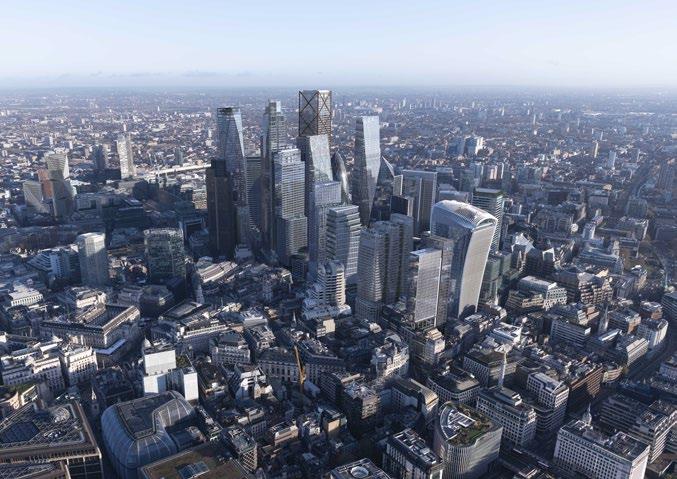
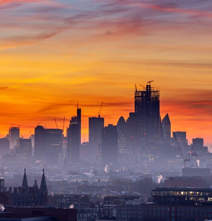
11.5.2 The City contains many tall buildings. In particular, the eastern part of the City has a concentration of tall buildings including iconic skyscrapers such as the Gherkin, 22 Bishopsgate, and the Leadenhall building. Tall buildings impart the City of London’s World City status to compete globally and to be a place where businesses seek to locate. Strategically planning for tall buildings in clusters can bring economic as well as townscape benefits. Clusters of tall buildings allow for concentration and agglomerations of businesses and related economic activity while they also provide higher densities and contribute towards creating a more defined impact on the overall City skyline. The eastern cluster forms a distinctive skyline with the highest density of commercial activity within the City and is required to accommodate a significant proportion of the City’s future growth in office floorspace. Capacity modelling demonstrates that the two clusters of tall buildings are required if the City is to meet objectively assessed need for office capacity over the lifetime of this Plan.
11.5.3 Tall building development can have transformational impacts upon a place and they should be located in sustainable locations where they don’t undermine the character of a place, or intrude into, and undermine cherished views of landmarks or urban skylines. They can also cause adverse environmental impacts such as reduction in daylight and sunlight, wind shear and overshadowing. It is therefore critical to determine appropriate areas and heights for tall buildings in order to respond to the opportunities that tall buildings may provide whilst also addressing and responding appropriately to the issues that they may create.
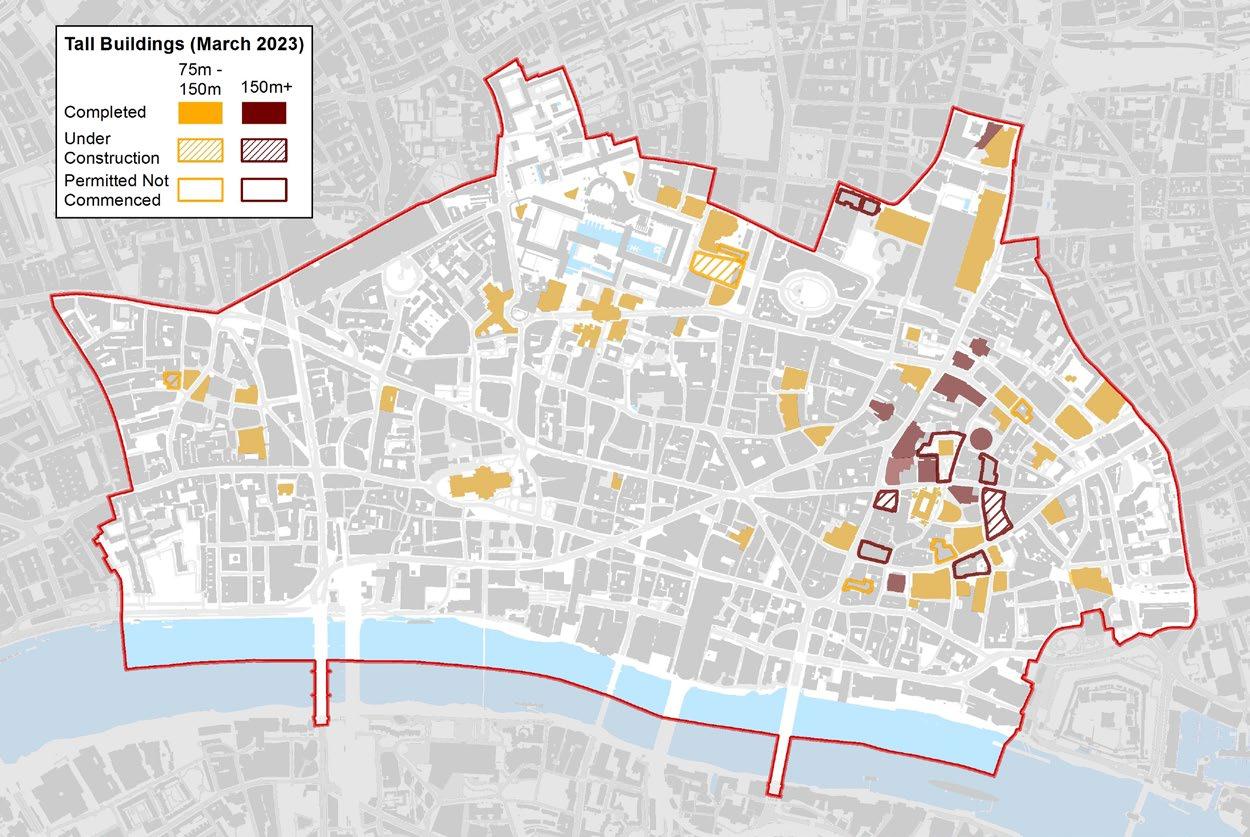
11.5.4 The tall building areas identified are the City Cluster and Fleet Valley areas. A comprehensive analysis of the character of the City informed the location of these tall building areas. The study found that, given its historic nature, and the prominence in local and wider strategic views, all parts of the Square Mile are sensitive or very sensitive to tall buildings. The City Cluster and Fleet Valley areas are the only broad areas found to be less sensitive and less constrained relative to other areas. Outside the identified tall building areas, tall buildings would be likely to very significant impacts on heritage assets and on protected views from places within and outside the Square Mile, and could significantly undermine the prevailing townscape and character of the area.
11.5.5 Different parts of the City have different characteristic features that make them distinct from each other. New development should be designed to fit in well within the existing context and have form, massing and height that positively responds to the townscape character.
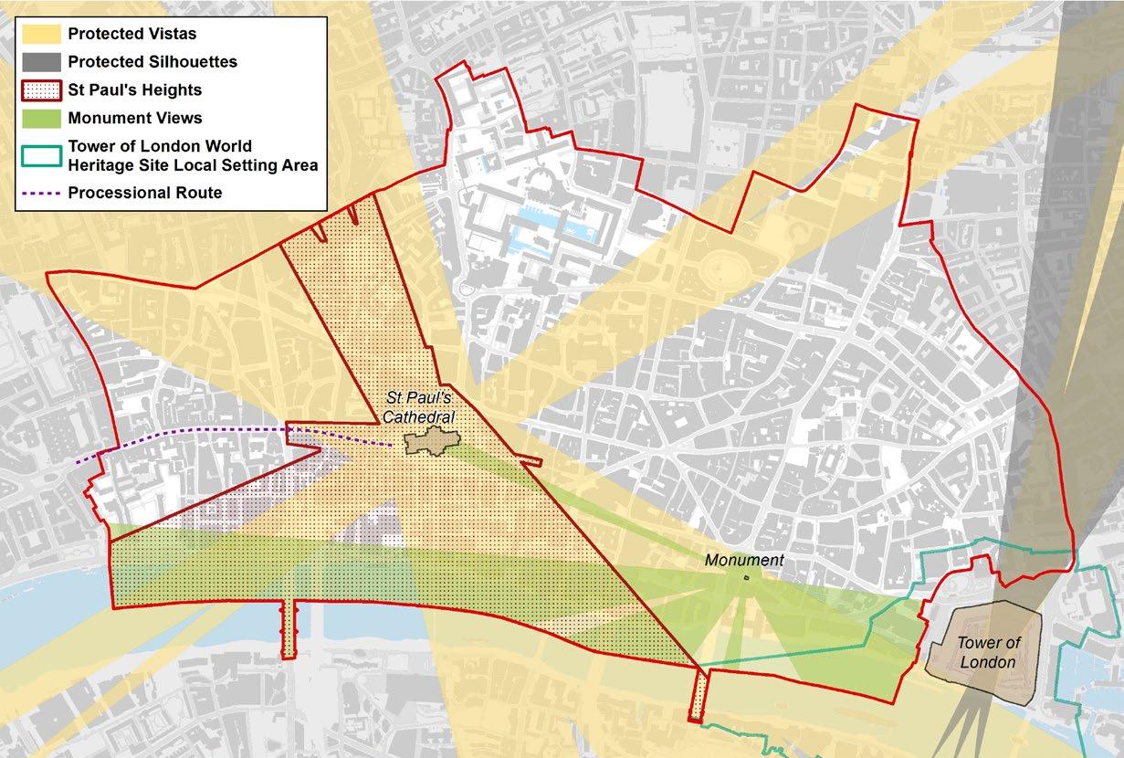
11.5.6 The heights of the buildings in the City Cluster and Fleet Valley areas were determined through extensive three dimensional modelling and mapping, informed by a detailed assessment of how the proposed massing of tall buildings in these areas could potentially impact the wider City and pan-London skyline. Both areas were assessed based on specific criteria, including the London Views Management Framework (LVMF), St Paul’s Heights, Monument Views, Tower of London approaches and representative views, and local strategic views.
11.5.7 Tall buildings are a characteristic and iconic feature of the City’s skyline. Well- designed tall buildings can respond positively to the character and the historic environment of the area. The creation of coherent clusters of tall buildings will help to ensure individual tall buildings are not isolated features but part of a recognisable skyline, with viewers able to identify the clusters spatially and distinguish them visually from important skyline features such as St Paul’s Cathedral.
11.5.8 The way tall buildings are experienced at ground level is an important consideration as tall buildings can have a significant impact on the streetscape and public realm. They can provide a range of activities and public spaces at ground level for people to walk and spend time. They can also benefit communities by providing publicly accessible viewing terraces and galleries.
11.5.9 The identification of the two tall building areas does not mean that all sites in the two areas are suitable. All new tall building proposals will need to satisfy the requirements of Policy S12 and other policies in this Plan and the London Plan. Policy S21 provides more details about the considerations that apply specifically to new tall building proposals in the City Cluster.
11.5.10 Tall buildings are high-profile developments with a wider impact, visible on the skyline across large parts of London. They provide City landmarks and should be designed to enhance the City’s skyline.
11.5.11 London Plan policy D9 B requires appropriate locations and appropriate tall building heights to be identified on maps in Development Plans. Figure 14 and Policies Maps C and D identify the areas where tall buildings may be appropriate in the Square Mile. Within these areas, Figure 15 and Policies Maps C and D identify contour rings. These contour rings set out the maximum tall building heights at specific points within the area. These maximum heights are those that the City Corporation considers to be the appropriate tall building heights based on an assessment of the potential impacts on strategic views and the following heritage assets: St Paul’s Cathedral, The Monument and the Tower of London World Heritage Site. In areas between the contour rings, tall building heights should be designed to successfully mediate between them. Where two contour rings overlap, Policies Map C identifies two heights. The lower height should be applied to the development that sits outside
the contour ring; the higher height should be applied to the development that sits inside the contour ring. In addition, part 8 of the policy requires the height and form of tall buildings to take into account strategic and local views; protected views are also addressed in Strategic Policy S13.
11.5.12 All tall building proposals should be accompanied by a Heritage Townscape Visual Impact Assessment that includes computer generated visualisations to illustrate the likely visual impacts of the proposed development, taking account of the cumulative impact of other proposed, permitted and existing tall buildings. Digital massing models of tall buildings should be submitted, in appropriate formats. The City Corporation will use these models to assess the impact of tall buildings on the local, City-wide and London-wide townscape and skyscape.
11.5.13 Within and in close proximity to the City Cluster, there are numerous heritage assets with the potential to be affected by tall buildings. The location, siting, bulk, massing, height and design of tall buildings should be informed by the potential impact on heritage assets, while recognising the juxtaposition of old and new architecture that already exists and that, in many instances, makes a positive contribution to the character of the Square Mile.
11.5.14 Tall buildings must not adversely impact on the operation of London’s airports, taking account of airport surface limitation heights. Consultation with London City Airport will be required on all proposals over 90m AOD and with Heathrow Ltd on all proposals over 150m AOD. Subject to this consultation, the maximum height of buildings, any equipment used during the
construction process and any subsequent maintenance or demolition must not exceed the Civil Aviation Authority’s (CAA’s) aviation safeguarding policy for central London, which sets a maximum height limitation of 309.6m (1,016 ft) AOD. Developers should undertake early liaison with the CAA, Heathrow and London City Airports regarding building heights and the height of cranes or other equipment to be used during construction, subsequent operation or demolition.
11.5.15 The development of tall buildings must take account of City Corporation Planning Advice Notes and SPDs on the potential microclimate and thermal comfort impacts from development at an early stage in the design process. Planning Advice Notes set out requirements for assessing the impacts of tall buildings on solar glare, solar convergence, sunlight, wind and thermal comfort explaining how they should be considered as part of the design process. Tall buildings should not interfere with telecommunications during construction and operation. Developers will be required to submit a Telecommunications Interference Survey identifying the impact of the development and any proposed mitigation measures.
11.5.16 Three dimensional computer models should be accompanied by data to verify the format, units of measurement and accurate positioning information relative to OSGB / Ordnance Datum co-ordinates. Submitted Accurate Visual Representations (AVRs) should be consistent with the supplied computer model but may reflect additional information to explain the physical appearance of the proposals. They should comply with the methodology and definitions included in Appendix C of the London View
Management Framework (LVMF). AVR materials should include representations of existing tall buildings and relevant consented schemes.
The City Corporation will protect and enhance significant City and strategic London views of important buildings, townscape and skylines by:
1. Implementing the Mayor of London’s London View Management Framework SPG to manage designated views of strategically important landmarks (St. Paul’s Cathedral and the Tower of London), river prospects, townscape views and linear views;
2. Protecting and enhancing significant local views of St. Paul’s Cathedral, through the City Corporation’s St. Paul’s Heights code and local views from the Fleet Street, Ludgate Circus and Ludgate Hill processional route; the setting and backdrop to the Cathedral; significant local views of and from the Monument and views of historic City landmarks and skyline features;
3. Securing an appropriate setting of and backdrop to the Tower of London World Heritage Site, ensuring its Outstanding Universal Value and taking account of the Tower of London World Heritage Site Management Plan (2016); and
4. Having regard to views of the City that have been designated by other Local Planning Authorities.
Reason for the policy
11.6.0 The City and its surrounding area contain many famous landmarks that are visible from viewpoints across London. Views of the City’s skyline from the River Thames are especially notable and certain local views of St. Paul’s Cathedral have been protected successfully by the City Corporation’s ‘St. Paul’s Heights’ code since the 1930s. The successful protection and restoration of the views depends on the long-term application of the Heights limitations to all sites within the area of control. The views protected by the Heights are sensitive to even small infringements. Consistent application of the limitations is therefore crucial to their successful protection of the views.
11.6.1 The London Plan sets out the overall view protection requirements which apply to Strategically Important Landmarks. Landmarks such as St. Paul’s Cathedral, the Monument and the Tower of London are internationally renowned and add to the City’s world class status.
11.6.2 The approach to views protection in this Plan is supported by more detailed guidance in the Protected Views SPD.
11.6.3 Protected vistas are defined geometrically from an assessment point at the view location to the strategically important landmark that is the focus of the protected vista. Each protected vista includes a landmark viewing corridor, within which development should not exceed the height of the threshold plane. Beside and behind landmark viewing corridors are the wider setting consultation areas, within which development that exceeds the defined LVMF threshold plane should not compromise the viewer’s ability to recognise and appreciate the strategically important landmark.
11.6.4 Other designated strategic views have defined assessment points but are protected by qualitative assessment of the impact of a proposal on the important elements of the view. For the City, most of the relevant views are river prospects from Thames bridges and the Riverside Walk. The Mayor of London’s London View Management Framework (LVMF) SPG (2012) provides more detail, including detailed management plans for each strategic view of landmarks such as St. Paul’s Cathedral and the Tower of London.
11.6.5 The LVMF defines a protected vista and a White Tower protected silhouette for the Tower of London. Any development in the wider setting consultation area in the background of this protected vista and the white tower protected silhouette should preserve or enhance the viewer’s ability to recognise the landmark and appreciate its Outstanding Universal Value. City sites have the potential to be intrusive in the view because of their relative
proximity to the Tower. Therefore, proposed new development in the City which exceeds the defined LVMF threshold plane for this view will not be acceptable as it will not preserve this view. The City Corporation’s Protected Views SPD provides further details and guidance on the protected views within the City.
11.6.6 The Tower of London has additional view protection, implemented through the Tower of London World Heritage Site Management Plan (2016). This defines and protects a range of settings of the Tower World Heritage Site, which includes its relationship to historic features that are visible in the urban landscape. All new buildings in the setting of the Tower should contribute to the quality of views both of and from the Tower.
11.6.7 The City Corporation has successfully protected views of St. Paul’s Cathedral through the St. Paul’s Heights policy for over 70 years. Applicants will be expected to submit drawings showing the relationship between the Heights limitations and the proposed development to ensure compliance with the Heights.
11.6.8 Some existing buildings exceed the Heights limitations and thereby partially obstruct the protected views of St Paul’s Cathedral. Upon alteration or redevelopment such buildings will be required to comply with the Heights limitations so that views obstructed at present will eventually be restored. Several infringing buildings have been redeveloped in compliance with the Heights, successfully restoring lost views.
11.6.9 Strict observance of the Heights limitations can sometimes lead to a uniform roofscape. Developers are encouraged to provide design solutions to help promote a more articulated, interesting roofscape within the area of the St. Paul’s Heights limitations while also keeping to the limitations imposed by the St. Paul’s Heights grid.
11.6.10 In some of the views protected by St Paul’s Heights tall buildings can be seen in juxtaposition to the Cathedral, compromising its dominance of the skyline. The relationship of tall buildings to the Cathedral varies with the viewpoint. In some cases, tall buildings can be seen behind the dome or western towers so that their outlines are impaired. From other viewpoints tall buildings appear above the roof of the Cathedral or cluster close to the Cathedral on the skyline. Views are compromised in these ways from the following locations: the south bank between New Globe Walk and Gabriel’s Wharf, and adjacent to Waterloo Bridge; and from the Millennium Bridge, Blackfriars Bridge, the southern part of Waterloo Bridge, Hungerford Bridge, and from Fleet Street. Within these views, new development and the redevelopment of existing tall buildings should aim not to worsen and, where possible, to improve the backdrop to the views. From other Heights viewpoints where no tall buildings appear in the backdrop and the Cathedral is seen against clear sky, new development should maintain this situation.
11.6.11 In views from the south bank west of Blackfriars Bridge and from Waterloo Bridge the Cathedral is seen in relation to the City’s eastern cluster of tall buildings. The cluster appears to the right of the Cathedral and does not intrude into its backdrop. There is a clear gap on the skyline between the Cathedral and the cluster, which it is important to retain. The height and massing of buildings in the cluster step upwards from this gap. This is important to the visual relationship between the Cathedral and the cluster, and should be maintained.
11.6.12 The City Corporation will protect local views of St Paul’s Cathedral when approaching along Fleet Street, Ludgate Circus and Ludgate Hill which forms part of the long established royal and state processional route between Westminster and the City. The views of St Paul’s are kinetic, changing as the viewer moves along the length of this route, depending on the topography and alignment of buildings. Development proposals that could be visible from places along this route should ensure that they do not impinge on the ability of the viewer to recognise and appreciate the silhouette of St Paul’s Cathedral, and that they maintain the current clear sky background profile. An indicative view background centre line is shown on Figure 16 to highlight this issue.
11.6.13 New development proposals should be well designed in their own right. Their bulk and form should not be based solely on the parameters set by the requirements and consideration of the protected views. In determining planning applications for tall buildings, the City Corporation will take account of guidance from the Design Council/CABE, Historic England and the Greater London Authority.
11.6.14 The City Corporation will co-operate with the Mayor, London boroughs and other local planning authorities, where proposed development outside of the City impacts on strategically important views of St Paul’s Cathedral, to ensure that development does not adversely impact on the view.
11.6.15 The City Corporation will supplement its assessment of strategic and locally protected views with a visual assessment carried out using 3D digital modelling technology. Developers should submit virtual models for all major development in an open source or other format compatible with the City Corporation’s 3D digital model.
St Paul’s Preservation Act and the St. Paul’s Depths
11.6.16 The City of London (St Paul’s Cathedral Preservation) Act 1935 defines an area near St Paul’s where development below prescribed depths is controlled in order to protect the stability of the Cathedral.