5 Flood Risk


• National
NPPF Chapter 12- Achieving well-designed places
NPPF Chapter 14- Meeting the challenge of climate change, flooding and coastal change
National Planning Policy Framework Planning Practice Guidance; Flood Risk and Coastal Change, updated August 2022 from DLUHC and MHCLG
Flood Risk Regulations 2009
Flood and Water Management Act 2010
• Regional
London Plan Policy SI 12 Flood risk management
London Plan Policy SI 13 Sustainable Drainage
London Plan Policy 5.12 Flood risk management
London Regional Flood Risk Appraisal 2018
Thames Estuary 2100 (TE2100)
London Surface Water Strategy
• Local
City Plan Policy 35 Flood risk
Strategic Flood Risk Assessment 2023 (SFRA 2023)
Local Flood Risk Management Strategy (LFRMS)
The frequency and severity of flooding is increasing due to climate change, and Westminster’s flood risk guidance and strategies are imperative to managing this risk. This chapter aims to provide guidance to ensure that development and land use decisions are made in a manner that considers both existing flood risk and future projections.
The increased occurrence of intense rainfall events can overwhelm existing drainage systems and lead to rapid and extensive surface water flooding. Whilst existing flood defences such as the Thames Barrier and the river walls afford Westminster with a high protection from the River Thames, these will need future upgrading.
The SFRA (2023) sets out the flood risk within Westminster coming from a number of sources including:
• Fluvial (river);
• Tidal (the sea);
• Surface Water;
• Sewers;
• Groundwater;
• Canals; and,
• Reservoirs.
Mitigating flood risk in Westminster is a priority as flooding not only poses a danger to the built environment, but poses immediate threats to human safety and can have long-term consequences for the environment. Flood risk assessments for developments must be a factor in determining suitability.
Certainland uses may be unsuitablein certain locations. Development that is in higher risk areas needs to incorporate flood-resistant design and construction techniques to mitigate flood risk. This may involve elevating structures above base flood elevation, using flood-resistant materials, designing proper and sustainable drainage systems, and implementing flood mitigation measures.
Integrating flood risk assessment, adaptation measures, and sustainable development practices will see more resilient communities, protect valuable assets, and safeguard our environment from the detrimental impacts of flooding
The city is divided into three flood zones as shown in our SFRA. The three categories, designated by the Environment Agency, are organised into a hierarchy of risk factor, with Flood Zone 3 split into two subcategories. These three flood zones relate to the probability of the River Thames and tidal (sea) flood risk.
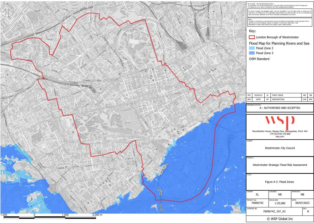
Flood Zone 1 comprises of most of the city and is designated as low risk of flooding; Flood Zone 2 is designated at medium risk of flooding and Flood Zone 3 is classified at high risk of flooding. The map above shows that areas at highest risk of flooding (Flood Zones 2 and 3) are in the southeast of the city.
Flood Zone 1
Flood Zone 2
Flood Zone 3a
Flood Zone 3b
This zone comprises land assessed as having less than a 0.1% (1 in 1,000) annual probability of river or sea flooding in any year (shown as ‘clear’ in Figure 7 – all land outside Zones 2 and 3).
This zone comprises land assessed as having between a 1% (1 in 100) and 0.1% (1 in 1,000) annual probability of river flooding (1%- 0.1%) or between a 0.5% (1 in 200) and 0.1% (1 in 1,000) annual probability of sea flooding in any year (land shown in light blue in Figure 7)
This zone comprises land assessed as having a 1% (1 in 100) or greater annual probability of river flooding or a 0.5% (1 in 200) or greater annual probability of flooding from the sea in any year (land shown in dark blue in Figure 7).
This zone comprises land where water from rivers or sea has to flow or be stored in times of flood.
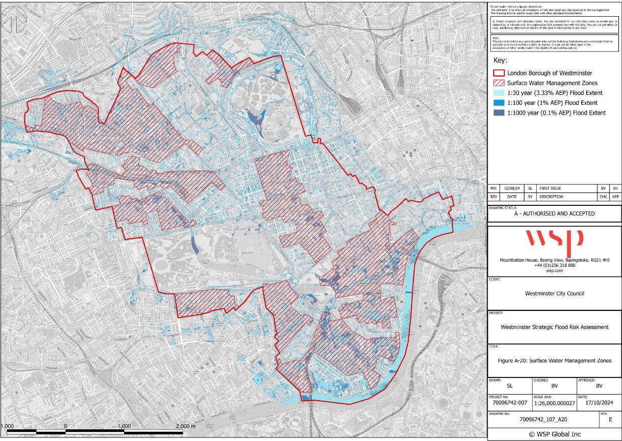
Surface water flooding is caused when rainfall overwhelms the capacity of the drainage systems. Surface water flooding is a direct, quick, and localised consequence of prolonged and/or heavy rainfall. Due to the heavily urbanised nature of Westminster, and the predominantly Victorian drainage infrastructure, there is a widespread risk of surface water flooding.
It is crucial to prioritise the design of drainage systems to minimise and mitigate surface water flood risk. Inadequate design and maintenance of drainage systems can result in surface water flooding during periods of heavy rainfall. The implemented measures should be capable of handling the most intense rainfalls expected throughout the lifespan of the structures (approximately 60 years for commercial development and 100 years for residential development). Moreover, they should contribute to reducing and slowing down the runoff from a site.
The previous SFRA (2019) referenced surface water flood risk hotspots which were based on the initial model created for the draft Surface water Management Plan and Preliminary Flood Risk Assessment. This model has since been updated and the surface water risk hotspots have been superseded by the surface water management zones, as shown in the figure below. Development proposed within these zones will therefore require more detailed flood risk assessments.
For new developments, the SFRA should inform site-specific flood risk assessments as evidence to support the sequential and exceptions tests for individual applications (discussed below) and suggests methods of reducing causes and impacts of flooding for developments.
The council has produced checklists that applicants can use as an FRA. These can be found on the planning flooding pages on our website. Further guidance also exists from central government on undertaking FRAs for planning applications.
The embankment wall defends Westminster from tidal and fluvial flooding. Responsibility for maintenance and repair of the flood wall sits with the council, and the relevant landowners whom we partner with, alongside Thames Water and the Environment Agency to ensure that the appropriate standards are maintained.
The Thames Estuary 2100 (TE2100) Plan sets out recommendations for managing tidal flood risk in the Thames Estuary. The TE2100 Plan has three phases of activity: until 2035 this is to maintain and improve current defences, safeguard areas required for future improvements, and monitor climate change indicators. TE2100 recommendations for Westminster are included in City Plan Policy 35 and include protecting and improving flood defences. The TE2100 Plan introduces a riverside strategy approach and states that riverside defences west of the Thames Barrier, including in Westminster, will need raising by 2050.
Property Flood Resilience (PFR) measures should be considered in areas at risk of tidal breach flooding where appropriate and depending on the level of risk and nature of the proposal. This can help minimise the impacts of flooding and facilitate recovery efforts sooner than conventional buildings. PFR measures should be considered also for basement developments within Flood Zone 2 and 3.
PFR could include:
• External walls: careful consideration of materials using low permeability materials to limit water penetration (avoiding using timber frame and cavity walls). Consider applying a water-resistant coating.
• Windows: flood resistant windows if they are to be located below the maximum water level expected. These windows should be watertight and be able to withstand the high pressure exerted on them when submerged under flood water (and the debris contained in the water).
• Air vents: should not be located below the maximum water level expected.
• Internal walls: avoid the use of gypsum plaster and plasterboard at the lower ground level; use more flood resistant linings (e.g. hydraulic lime, ceramic tiles). Avoid use of stud partition walls.
• Fitting, fixture and services: if possible, locate all fittings, fixtures and services above the maximum water level expected to minimise damage by flood waters. Avoid chipboard and medium density fibreboard. Consider the use of removable plastic fittings. Use solid doors treated with waterproof coatings. Avoid fitted carpets. Locate electrical, gas and telephone equipment and systems above design flood level. Fit anti-flooding devices to drainage systems to prevent surcharged flooding. These devices act as one-way valves, preventing sewage backing up into the buildings through sinks and toilets.
The most effective approach to address surface water flood risk is to incorporate sustainable drainage systems (SuDS), which offer a method to manage surface water in a way that emulates the natural environment. They attenuate surface water runoff from heavy rainfall events and slow the flow of water, which results in less pressure on the combined sewage system. SuDS can also yield wider benefits, such as:
• Capturing, reusing and filtering rainwater
• Providing amenity benefits through recreational areas
• Providing biodiversity benefits
Avoiding development in areas at risk of surface water flooding is not always possible, particularly in a densely built-up city such as Westminster where there are few development sites available. Planning for new developments requires careful consideration of surface water flood risk and this guidance aims to assist in designing developments that mitigate associated risks. Additionally, this document emphasises the potential of brownfield redevelopment as an opportunity to locally reduce surface water flood risk in a sustainable manner through the implementation of SuDS. By reducing the peak rate and volume of surface water runoff, we can improve resilience compared to baseline conditions.
Policy 35J requires that new developments must incorporate SuDS to alleviate and manage surface water flood risk. The aim is to minimise surface water runoff from developments, reduce the strain on drainage systems, and contribute to the overall resilience of communities in the face of flooding events.
Types of sustainable drainage measures to consider:
• Green roofs: Installing green roofs on buildings helps to reduce stormwater runoff by retaining rainwater and allowing it to be absorbed. Green roofs also provide additional benefits such as improving air quality, reducing urban heat island effect, and enhancing biodiversity.
• Permeable paving materials: Utilising permeable pavement materials, such as permeable concrete or porous materials, allows rainwater to infiltrate through the surface into the underlying soil or drainage system. Permeable pavement reduces rainwater runoff and helps to mitigate flooding and water pollution. All new developments, with associated driveways and paving, should utilise permeable materials to allow for the infiltration of rainwater into the ground. The requirement also applies to major renovations or modifications, that require planning permission, that involve substantial changes to existing driveways or paving. Permeable materials should ensure their durability, stability, and long-term performance.
• Rain gardens: Rain gardens are shallow, landscaped depressions that capture and store rainwater runoff. They are designed with vegetation and engineered soils that promote filtration of rainwater. Rain gardens enhance the aesthetic value of urban areas, support biodiversity, and improve water quality by removing pollutants, but should be carefully designed to avoid adverse impacts on existing trees.
• The emerging Westminster’s Highway SuDS Design Manual provides detailed designs for a range of SuDS features suitable to be retrofitted into the public realm.
The Sequential Test ensures that a sequential approach is followed to steer new development to areas with the lowest probability of flooding. However, given the various flood risks, densely developed urban landscape, limited land availability, complex development pressures and land-use patterns in Westminster, it is impractical to employ the Sequential Test to distinguish between potential development sites. Therefore, development within Flood Zones 2 and 3 will be considered and, generally, proposals in these zones will be considered sequentially acceptable, contingent upon compliance with the NPPF Flood Risk Vulnerability Classification and fulfilling the Exception Test requirements where applicable (e.g., residential development in Flood Zone 3). Refer to the Vulnerability Classification Table for development categories, their vulnerability classifications, and the need for an exception test.
The Exception Test is required for certain development sites following application of the Sequential Test. The Exception Test must demonstrate that the development provides wider sustainability benefits to the community that outweigh flood risk, and that the site is safe from flood risk for its lifetime.
Westminster benefits from significant Tidal Flood Defence infrastructure and under ordinary operational conditions, is not at risk of flooding from the Thames. It is considered appropriate to assess flood risk from tidal and fluvial sources within Westminster as Low, however some areas are considered at greater residual risk when located in a Rapid Inundation Zone (RIZ) as shown in Figure 1. These areas will therefore require greater consideration of factors such as flood resilience and safe access and egress.
Avoiding areas at risk of surface water flooding is difficult however new development can be designed to mitigate any associated risk. In addition, all brownfield redevelopment provides the opportunity to reduce surface water flood risk locally in a sustainable way, by implementing SuDS, and reducing the peak rate and volume of surface water run-off when compared to the baseline condition. Redevelopment within areas of existing surface water flood risk must include appropriate mitigation measures to reduce flood risk.
Both elements of the Exception Test should be satisfied, where applicable, for development to be allocated or permitted. For the Exception Test to be passed:
Development that must be in a flood risk area should provide wider sustainability benefits to the community that outweigh the flood risk, such as on-site greening or improving the energy performance of a building; and s site-specific Flood Risk Assessment, as described in section 7.3.1.4, must demonstrate that the development will be safe for its lifetime taking account of the vulnerability of its users, without increasing flood risk elsewhere, and, where possible, reducing flood risk overall through the installation of SuDS
Table 9: Development Types and Appropriate Flood Zone Designations Vulnerability Classification Development Types
Essential infrastructure
Essential transport infrastructure (including mass evacuation routes) which has to cross the area at risk.
Essential utility infrastructure which has to be located in a flood risk area for operational reasons, including electricity generating power stations and grid and primary substations; and water treatment works that need to remain operational in times of flood.
Wind turbines.
Solar farms.
Highly vulnerable Police and ambulance stations; fire stations and command centres; telecommunications installations required to be operational during flooding.
Emergency dispersal points.
Basement dwellings.
Caravans, mobile homes and park homes intended for permanent residential use.
Installations requiring hazardous substances consent. (Where there is a demonstrable need to locate such installations for bulk storage of materials with port or other similar facilities, or such installations with energy infrastructure or carbon capture and storage installations, that require coastal or water-side locations, or need to be located in
ET X X
ET X X
ET X X
other high flood risk areas, in these instances the facilities should be classified as ‘Essential Infrastructure’).
More vulnerable Hospitals.
Residential institutions such as residential care homes, children’s homes, social services homes, prisons and hostels.
Buildings used for dwelling houses, student halls of residence, drinking establishments, nightclubs and hotels.
Non–residential uses for health services, nurseries and educational establishments.
Landfill* and sites used for waste management facilities for hazardous waste.
Sites used for holiday or short-let caravans and camping, subject to a specific warning and evacuation plan.
Less vulnerable Police, ambulance and fire stations which are not required to be operational during flooding.
Buildings used for shops; financial, professional and other services; restaurants, cafes and hot food takeaways; offices; general industry, storage and distribution; non-residential institutions not included in the ‘more vulnerable’ class; and assembly and leisure.
Land and buildings used for agriculture and forestry.
Waste treatment (except landfill* and hazardous waste facilities).
ET X
ET X
ET X
ET X
X
Watercompatible development
Minerals working and processing (except for sand and gravel working).
Water treatment works which do not need to remain operational during times of flood.
Sewage treatment works, if adequate measures to control pollution and manage sewage during flooding events are in place.
Car parks.
Flood control infrastructure.
Water transmission infrastructure and pumping stations.
Sewage transmission infrastructure and pumping stations.
Sand and gravel working.
Docks, marinas and wharves.
Navigation facilities.
Ministry of Defence installations.
Ship building, repairing and dismantling, dockside fish processing and refrigeration and compatible activities requiring a waterside location.
Lifeguard and coastguard stations.
Amenity open space, nature conservation and biodiversity, outdoor sports and recreation and essential facilities such as changing rooms.
Essential ancillary sleeping or residential accommodation for staff required by uses in this category, subject to a specific warning and evacuation plan.
✓ Development is appropriate X Development is not appropriate ET: Exception Test will be required.
* In Flood Zone 3b (functional floodplain) essential infrastructure that has passed the Exception Test, and water-compatible uses, should be designed and constructed to:
- remain operational and safe for users in times of flood;
- result in no net loss of floodplain storage;
- not impede water flows and not increase flood risk elsewhere.
Site specific FRAs19 are standalone documents submitted by the developer to accompany a planning application. In those instances where an Environmental Statement is required for a development the developer should ensure that the FRA is attached and informs the Environmental Statement.
The detail provided in the FRA should be based on up-to-date existing flooding information (e.g. SFRA 2023, Environment Agency’s Flood Map for Planning, breach modelling results taken from the Thames Tidal Upriver Breach Inundation Assessment and history of flooding at the site) and be commensurate to the probability and associated risk of flooding for the proposed development taking into account the nature of the proposals: for example risk for a commercial property is generally lower than that for a residential development. Where the probability of flooding to the site is negligible there is little benefit to be gained in assessing the potential risk to life and/or property as a result of flooding.
Rather, emphasis should be placed on ensuring that runoff from the site is controlled safely and sustainably on-site and does not exacerbate flooding lower in the catchment.
We recommend visiting our website, which provides a guidance for developing FRAs. The level of information included should be proportionate to the scale/nature/location of the development and the degree of flood risk. The Environment Agency and any other relevant bodies, for example Thames Water, should also be consulted. These relevant bodies will be able to provide useful background information to inform the assessment and the mitigation of flood risk through design.
The FRA must demonstrate how flood risk will be managed for a proposed development, without increasing flood risk to the surrounding areas Any associated surface water drainage strategy should utilise SuDS, unless there are practicable reasons for not doing so, to ensure the sustainable management of surface water runoff. The council then makes a decision as to whether the development is acceptable based on the evidence provided within the FRA.
City Plan policy 35 sets out that for applications proposing more vulnerable uses within the areas at risk of tidal breach flooding, especially if =within the Rapid Inundation Zone, should prepare a Flood Warning and Evacuation Plan (FWEP) and can be appended to the FRA. A FWEP should set out site specific actions to take in preparation of and during a flood event. Its aim is to reduce risk to life, mitigate damage, and enable a safe and orderly evacuation of site users during a flood. Information that could be contained within a FWEP include:
• Raising awareness of the flood risk to the site;
• Providing information on the Environment Agency Flood Warning Service (if applicable) and flood lead in times;
19 Flooding and planning application requirements | Westminster City Council
• Detailing how the plan is triggered, who is responsible for participating in the plan, and how to disseminate flood warning information among site users;
• Establishing safe access and egress routes to a safe refuge location;
• Providing information on alternative safe refuge within the site, should evacuation not be possible;
• Establishing procedures for implementing and maintaining the plan.
As per the requirements outlined in City Plan Policy 35J and policy SI 13 of the London Plan, it is mandatory for all new developments to incorporate SuDS, unless there are substantial practicable reasons for not doing so. The objective of SuDS is to achieve run-off rates like those of greenfield sites and ensure that surface water run-off is managed as close to its origin as feasible. This approach aims to decrease the overall volume of run-off generated, mitigate associated flood risks, and deliver significant additional benefits unrelated to flood risk management.
Additionally, all proposed driveways for new developments should incorporate permeable paving whenever feasible. This is essential to effectively manage surface water run-off. If impermeable materials are proposed for the driveways, obtaining planning permission will be necessary to proceed with the development. Flood Risk Assessments guidance can be found on our website.
All basement developments, as defined and set out in policy 45 in the City Plan, located within areas of surface water flood risk areas will also be required to include a site-specific Flood Risk Assessment; Flooding and planning application requirements Westminster City Council. All basements at risk of flooding from surface water must have internal stair access to a higher floor above the design flood level to be utilised in an emergency. Evidence must be provided to support this assessment.
By adopting proactive measures during the planning and design stages allows for the early identification of potential hazards and vulnerabilities associated with the proposed basement development. This assessment helps developers, architects, and planners understand the site's flood history, drainage characteristics, and floodplain information, enabling more informed decisions to minimise risks.
To ensure the safety and resilience of new developments it is strongly encouraged that any proposed basement development, including change of use and; regardless of flood zone category, seek advice and employ a flood risk specialist. While it may not be a statutory requirement, this assessment will help to ensure you understand and mitigate potential flood risks associated with basement dwellings.
With the growing frequency and intensity of extreme weather events, including heavy rainfall and flooding, it is crucial to consider flood risk for basement developments. Basements are particularly vulnerable, categorised as highly vulnerable, due to their lower elevation and often situated below the ground level. Flooding can result in significant damage to properties and pose a risk to occupants- a comprehensive Flood Risk Assessment can help identify appropriate and adequate flood mitigation measures.
City Plan Key Performance Indicator 20: Applications granted planning permission against Environment Agency advice on flood risk.