One big challenge in the search for energy is that it comes in a verylarge container.
In the search for more oil and gas, you need reliable information and powerful software to help turn that information into knowledge. Knowledge reduces uncertainty and helps you make informed decisions. For more than ten years IHS AccuMap has provided the most comprehensive and trusted oil and gas information and software tools for the Western Canadian Sedimentary Basin, Northern Territories, and East Coast. From mineral rights to surface information, E&P data to M&A, we offer an unmatched breadth of data and analysis tools. From now on, the synergy of tools and expertise known as IHS AccuMap will be IHS Energy. We have more data and more ways to use it than anyone in the industry. Our unparalleled information, industry standard software, and superior services can power your next decision. And the next. And the next. And the next.
Please submit RESERVOIR articles to the CSPG office.Submission deadline is the 23rd day of the month,2 months prior to issue date.(ie:January 23rd for the March issue)
To publish an article,the CSPG requires both hard and electronic copies of the article,including details of its electronic file format (ie:Word 6.0).
COORDINATINGEDITOR &OPERATIONS
Jaimè Croft
CSPG
Tel:403-264-5610 Fax:403-264-5898
Email:jaime.croft@cspg.org
TECHNICAL EDITOR
Ben McKenzie
GEOCAN Energy Inc.
Tel:403-261-3851
Email:bjmck@telusplanet.net
ADVERTISING
All inquiries regarding advertising and technical specifications should be directed to Tim Howard,CSPG.Submission deadlineis the 23rd day of the month,2 months priorto issue date.All advertising artwork shouldbe sent directly to:CSPG 160,540-5th Ave SW Calgary,Alberta,Canada T2P 0M2
Tel:403-264-5610 Fax:403-264-5898
Email:cspg@cspg.org
The RESERVOIR is published 11 times per year by the Canadian Society of Petroleum Geologists including a joint issue for the months of July/August.
Advertisements,as well as inserts,mailed with the publication are paid advertisements. No endorsement or sponsorship by the Canadian Society of Petroleum Geologists is implied.
The CSPG Rock Shop is an attractive and affordable way for advertisers to present their services to the CSPG Readership.Spaces are sold at a business card sizes (3.5” wide by 2” high) and will eventually fill an entire Rock Shop page. For more information or to book a space please contact:Tim Howard at the CSPG Tel:403-264-5610 Email:cspg@cspg.org
The contents of this publication may not be reproduced either in part or in full without the consent of the publisher.
&
Additional copies of the RESERVOIR are
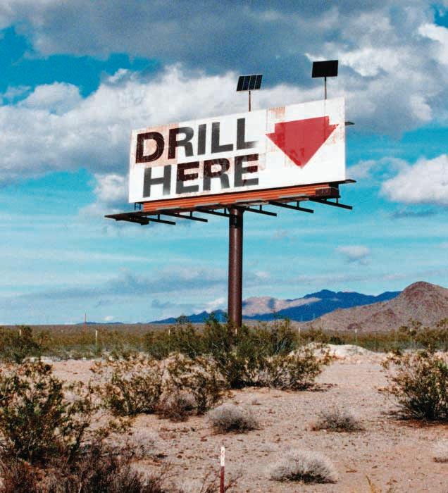
If only it were this simple.
It’s never simple.But at Core Laboratories Reservoir Technologies Division,we can help reduce the uncertainty.We provide 2D and 3D land and marine seismic processing,advanced seismic and rock properties analysis,and reservoir description and characterization.We provide sound solutions to better understand your reservoir.Core Lab - we’ll help make the signs more clear.
CORPORATE MEMBERS
THE CSPG GRATEFULLY ACKNOWLEDGES ITS *CORPORATE MEMBERS
ABU DHABI OIL CO. LTD.
ARCHEAN ENERGY LTD.
BURLINGTON RESOURCES CANADA ENERGY LTD.
CALPINE CANADA
CANADIAN FOREST OIL LTD.
CONOCO CANADA RESOURCES LIMITED
DEVON CANADA CORPORATION
DOMINION EXPLORATION CANADA LTD.
ECL CANADA
EL PASO OIL & GAS CANADA INC.
ENCANA CORPORATION
HUNT OIL COMPANY OF CANADA, INC.
HUSKY OIL OPERATIONS LTD.
IMPERIAL OIL RESOURCES LIMITED
LARIO OIL & GAS COMPANY
MJ SYSTEMS
MURPHY OIL COMPANY LTD.
NCE RESOURCES GROUP INC.
NEXEN INC.
NORTHROCK RESOURCES LTD.
PENN WEST PETROLEUM LTD.
PETRO-CANADA OIL AND GAS
PROVIDENT ENERGY LTD.
REEVES WIRELINE
SAMSON CANADA
SECURITY DBS.
SHELL CANADA LIMITED
SPROULE ASSOCIATES LIMITED
SUNCOR ENERGY INC.
TALISMAN ENERGY INC.
TOTALFINAELF E&P CANADA LIMITED
TUCKER WIRELINE SERVICES CANADA INC.
UPTON RESOURCES INC.
*CORPORATE MEMBERS AS OF NOVEMBER 24, 2002
CSPG Annual Awards Banquet February 16,2003
watch your February Reservoir for details and ticket information
After much discussion,the Executive has made the decision to try a new approach to the way it handles its corporate relations and advertising solicitation.In the past,the CSPG relied on its volunteer base to perform most of the business functions of the Society.Over the last decade the Society has hired staff to handle the day-to-day business affairs,allowing the Volunteers and Executive to utilize their limited time more effectively.I have been involved with the CSPG since the mid-1970s and it is my observation that the amount of time that a volunteer can contribute to the Society has dropped dramatically.In general,companies are not willing to give their employees as much time off to run the day-to-day affairs of the Society.Additions to the CSPG staff were made after extensive discussions with the Executive and the Membership.Each of our four staff members has assumed increasing levels of responsibility since being hired.Over the next year there will be an introduction to each of our office staff in the Reservoir with an outline of their respective responsibilities.
The decision to contract the Corporate Relations role is based on a number of factors,the most
significant of which are the recent resignation of our volunteer Corporate Relations Director and the termination of our arrangement with MacdonaldCole Inc.(MCI) to design,publish,and distribute the Reservoir in return for advertising revenue.As MCI moves in another corporate direction,they felt that the Reservoir initiative did not fit with their strategy.The CSPG wishes Judi,Grafton,Steven and all the staff at MacdonaldCole Inc.well in their future endeavors and thank them for their efforts on a range of CSPG projects in the past half-decade.The Reservoir will continue to be produced by the Society in its present form for 2003.
The CSPG Executive has decided to create the position of Corporate Relations Manager.The position will be a one-year contract and the incumbent is expected to demonstrate a tangible net-dollar addition to the Society’s bottom line.The incumbent will not only be responsible for advertising in the Reservoir but will also handle all aspects of the Society’s advertising,corporate membership,and sponsorship.The Corporate Relations Manager will also assist the Educational Trust Fund in its ongoing funding needs and will coordinate the funding, sponsorship,and advertising requirements of the various CSPG committees.The Executive also feels that the Society has yet to fully capitalize on the corporate potential in the energy sector, and believes this is a step that we as a Society must take.We would appreciate any feedback that you,the Membership,can provide.Please contact one of the Executive by either email or phone with your brickbats or bouquets.
Bruce G.McIntyre Past President
LETTER TO THE MEMBERSHIP
To the CSPG Membership:
We would like to inform you about the predicament of Lori Wilcox who works at the Core Research Center.Lori is in a bit of a bind these days and could really use our help. Due to long-term denture use,her jawbone is receding and could break at any time through simply chewing food.To rectify this problem she needs major dental surgery.Unfortunately, neither Alberta Healthcare nor her insurance through the Energy Utilities Board will cover the cost.Lori is unable to afford the surgery so we have decided to help by raising funds on her behalf.All donations will be anonymous to Lori and to us.Unfortunately,donations are not tax deductible.
Lori is scheduled for surgery January 29,2003. The total bill will be about $20,000.00.We have set up a bank account for collection purposes at the Bow Valley Branch of the Royal Bank in the name of “Friends of Lori” Transit #:2319,Account Number:1024603. The account is set up to receive money from folks like you.
There are many opportunities to help people in the general community.This is an opportunity to help “one of our own”.
Thank you,
Shelley Moore,403-231-9962
Caroline Williams,403-298-6256
Ian Muir,403-205-6726
Richard Brandley,403-247-2140
JANUARY LUNCHEON
Interpretation of Incised Valleys,Deltas and Estuaries in the AlbertaForeland Basin - Stratigraphic Implications and Constraints
SPEAKER
Gerry E.Reinson Consulting Geologist
CO-AUTHOR
J.Dennis Meloche
Devon Canada Corporation
11:30 am Thursday,January 9,2003
TELUS, CONVENTION CENTRE CALGARY, ALBERTA
Please note:
The cutoff date for ticket sales is 1:00 pm, Monday,January 6th,2003. Ticket Price is $25.00 + GST.
With respect to facies analysis,the last 15 years could be considered as the "Age of Incised Valley Fill (IVF)".Furthermore, estuary deposits have become synonymous with IVF.Published papers identifying ancient estuary sequences and incised valleys, based on a rigidly applied tripartite model, are commonplace and often misleading. The problem arises from the "force-fitting" of the tripartite model based on the assumption that it is definitive for all ancient estuary successions.On the contrary,it represents but one of the stages in a continuum ranging from the drowned river valley estuary to the delta estuary. Estuary deposits can occur in vastly different depositional settings,(ie:incised valley or classical delta),but because of the current
paradigm it is erroneously accepted that drowning of an incised valley must be a prerequisite for estuary formation.
The recognition of estuarine deposits does not require the presence of an incised valley or bayhead delta,or even the presence of a significant bounding surface at the base. Adherence to the tripartite model involves the need to identify estuarine point-bar deposits with attendant IHS beds,when in fact such deposits constitute a very small proportion of many estuary fills. Laterally extensive muddy bay-fill facies, accumulated during coastal inundation,are often overlooked because of the constraints imposed by the rigid application of the model. At the facies analysis level,particularly when interpreting cored sequences,it is difficult to distinguish between a distributary bay-fill of a delta complex and an estuary bay-fill of a drowned "incised-valley" complex.That is because both sequences display similar physical and biological signatures,which are representative of brackish environments.
It is important to recognize that a range of estuary system types is present in the Alberta Foreland Basin,and the principal factors effecting system types are variations in rate of sediment supply and rate of change of accommodation.Several examples can be shown to illustrate this including the McMurray/Wabiskaw,Ostracod,Glauconitic, Viking,Dunvegan,and Belly River reservoir units.
Finally,it is evident that in many cases we geologists have misinterpreted autocyclic changes within delta complexes of the WCSB as regional shifts in sea level, primarily because of the current "in vogue" IVF paradigm.From an exploration perspective,it is very important to recognize these two fundamentally different
JANUARY LUNCHEON
Genetic Approach to Understanding a Complex Hydrocarbon System: Caribbean Colossus of East Venezuela
SPEAKER
Emery D.Goodman
AAPG Distinguished Lecturer
ExxonMobil Exploration Company
CO-AUTHORS
Lori L.Summa
Mark Richardson
ExxonMobil Upstream Research Company
processes in the rock record,since the model we ultimately select constrains our mapping and steers our exploration efforts.
BIOGRAPHY
Gerry Reinson received his Bachelors and Masters degrees from the University of Saskatchewan, Saskatoon,and his Ph.D.in sedimentology from the Australian National University in Canberra.He has extensive experience in the fields of petroleum geology,environmental geology,and marine geology,having worked in both the public and private sectors as an applied research scientist,manager,and petroleum explorationist.He is currently an independent consultant specializing in reservoir facies mapping at both regional and field/pool scales.Gerry's professional interests encompass both clastic and carbonate sedimentology as applied to basin analysis,stratigraphy and reservoir characterization,petroleum resources evaluation,and technical management.He has published numerous articles on the above and related topics.
BIOGRAPHY
Dennis Meloche received his Bachelors and Ph.D.degrees in Geology from the University of Western Ontario.He has over 20 years of petroleum geology experience primarily in the Western Canada Sedimentary Basin,but also in Canada's frontier areas and internationally. His work experience includes employment with both major and junior oil companies,as well as a brief tenure as an independent consultant. More than half of this has been in an advisory or technical support role.His expertise lies in the fields of clastic stratigraphy,petrography, sedimentology and facies characterization related to basin analysis,petroleum exploration and reservoir modeling.Dennis is currently geological advisor (clastics) with Devon Canada Corporation.
Ian O.Norton
Arthur R.Green
ExxonMobil Exploration Co.
11:30 am Thursday,January 23,2003
TELUS, CONVENTION CENTRE CALGARY, ALBERTA
Please note:
The cutoff date for ticket sales is 1:00 pm,Monday,January 20th,2003. Ticket Price is $25.00 + GST.
Venezuela's well known,giant hydrocarbon provinces are characterized by complex paleo-tectonic,fluid flow,and stratigraphic histories.This complexity makes predicting the distribution of rocks and fluids away from control difficult for those exploring for and developing hydrocarbon resources.We have used the eastern Venezuela Basin portion of a regional study,undertaken to evaluate available acreage,as an example of an integrated analysis of hydrocarbon systems.This scalable approach includes construction of a new plate tectonic model that is keyed to basin events,analysis of crustal types underlying sedimentary basins, and culminates with molecular geochemistry of reservoired hydrocarbons,seeps,and fluid inclusions.
The prolific Eastern Venezuela Basin is part of an active,curvilinear belt of subduction, transpression,and tectonic thickening,and has been compared to other global foreland basins. However,at both crustal and lithospheric scales,its genesis and evolution are unique. At the lithospheric scale,a combination of Atlantic, Caribbean and Pacific plate tectonic events influenced its development - it is currently located over one of the largest measured gravity lows on earth.At crustal and basin scales,it contains world-class hydrocarbon source rocks whose thermal maturation history is complexand spatially variable due to the interplay of these tectonic events.The superposition of theseelements with late-developing, but long-lived structural and stratigraphic fairways,led to efficient migration of large volumes of oil and gas.Significant volumes were lost before regional seals were deposited.
At least four hydrocarbon source rocks contribute to oil and gas accumulations. Cretaceous oil-prone,marine source rocks,and Miocene oil and gas-prone,paralic source rocks are well documented.We also identified probable Jurassic hypersaline-lacustrine,and Albian carbonate source rocks based on new data and analyses.We hypothesize that,1) the older organic-rich rocks formed under restricted conditions within continental rifts lying at high angles to the eventual passive margins and,2) inverted Mesozoic normal faults underlie the thin-skinned structures of the Serrania del Interior.Probable Albian and Jurassic source rocks provide the incentive to investigate deeper oil and gas plays.
Same Duo... Same Duo... New Location!
MacKeith and Rivett. Same great duo, and now they have moved to a new office location. MacKeith and Rivett. Same great duo, and to a new office location.
Neil MacKeith and Arny Rivett have formed a great partnership to bring you their combined expertise and experience in the oil and gas business. Their combined years gives them the edge in the following:
■ Extensive Experience in Domestic and International areas
■ Interpretation Services
•Interpretation of 2D & 3D seismic data
•2D & 3D seismic Program Planning
•Preparing Geographical information, culture and wells for workstation loading
•Loading 2D & 3D seismic data to WinPix
■ Mapping Services
•Mapping Geological and Geophysical data
•Processing & plotting satellite imagery with overlays of pipelines, roads, block outlines
Suite 770, Epcor Place
505 - 2nd Street SW, Calgary, Alberta T2P 1N8 Tel: 403 265 7655 Fax: 403 265 7659
The Tertiary,eastward-younging development of depocenters across Venezuela's northern margin, was supplemented by local,tectonically-induced subsidence.Rapid burial then created the opportunity for unusually efficient migration and trapping of Neogene-expelled hydrocarbons in eastern Venezuela.The complex,mapped distribution of oils of different qualities and mixtures is explained and predicted by an integrated model that incorporates source facies,burial/maturation,migration,mixing, and preservation aspects.
BIOGRAPHY
Emery D.Goodman received his Ph.D.from the University of California in Santa Barbara.His M.S.and B.S.were received from the University of South Carolina and The New York State University respectively.Emery worked with Shell Oil from 1980 to ‘85 and has been with Exxon Production Research since ‘89;at present he is the Project Manager of the Eastern Gulf of Mexico Exploration department with ExxonMobil in Houston,Texas.Emery's professional interests include Basin analysis including tectonics,hydrocarbon systems,trap integrity analysis,and structural geology. Emery is focused on the geology of northern South America as well as southern Asia and California.
Arny Rivett
Neil MacKeith
FEBRUARY LUNCHEONS
Geological History of Egypt and Libya and Their Hydrocarbon Systems
SPEAKER
Ed Tawadros
Consultant
11:30 am Tuesday,February 11,2003
TELUS CONVENTION CENTRE CALGARY, ALBERTA
Please note:
The cut-off date for ticket sales is 1:00 pm,Wednesday,February 5th. Ticket price is $25.00 + GST
The combined recoverable hydrocarbon reserves of Egypt and Libya are estimated at 39 billion barrels of oil and 83.5 TCF of gas.These hydrocarbon accumulations resulted from favorable tectonic and depositional settings.Deposition took place in continental rift basins,cratonic basins, and passive continental margin basins.These basins include:1) Mediterranean Basin,2) Nile Basin,3) Northern Egypt Basin,4) Gulf of Suez and Red Sea,5) Cyrenaica Basin,6) Sirte Basin,7) Murzuq Basin,8)
Ghadames Basin,9) Kufra Basin,and 10) Jifarah Basin.The Sirte Basin contains approximately 70% of Libya’s reserves and the Gulf of Suez contains 70% of Egypt’s reserves.
Reservoirs range in age from Precambrian to Pliocene and include fractured basement rocks,fractured quartzites,peri-glacial deposits,turbidites,continental,deltaic and shallow marine sandstones,and carbonate buildups.The dominant traps are structural, but stratigraphic and combination traps are also present.Frequent Oceanic Anoxic Events (OAE) took place throughout the Phanerozoic and resulted in the deposition of extensive black shales with TOC values exceeding 7%.These shales provide the source rock for hydrocarbons in the area.
The Precambrian-Recent history of Egypt and Libya has been divided into nine tectonic/depositional phases.These phases include:1) Magmatic Arc Phase (PrecambrianLower Cambrian),2) Graben Phase (MiddleUpper Cambrian),3) Glacial Phase (Ordovician-Silurian),4) Tectonic Arches Phase (Devonian-Permian),5) Mediterranean Phase (Triassic-Lower Jurassic),6) Atlantic Phase (Upper Jurassic-Lower Cretaceous), 7) Alpine Phase (Upper Cretaceous-Eocene), 8) Gulf of Suez Phase,and 9) Nile Phase (Pliocene-Pleistocene).Each of these phases
FEBRUARY LUNCHEONS
Surface Exploration Case Histories,a new AAPG-SEG Book;and an Alberta Devonian Wildcat Just Drilled Using the Discussed Technologies
SPEAKER
Leonard A.LeSchack Hectori Inc.
11:30 am Tuesday,February 25,2003
TELUS CONVENTION CENTRE CALGARY, ALBERTA
Please note:
The cut-off date for ticket sales is 1:00 pm,Wednesday,February 19th.
Ticket price is $25.00 + GST
In September 2002,AAPG and SEG jointly published a book entitled, “Surface Exploration Case Histories:Applications of Geochemistry, Magnetics,and Remote Sensing.” This book was compiled and edited by Dietmar Schumacher and myself.It was inspired by the success of AAPG Memoir 66, “Hydrocarbon Migration and Its Near-Surface Expression,” and by requests from industry for a collection of exploration case histories that demonstrate the proper acquisition,interpretation, and integration of geochemical data with conventional geologic and seismic data. The book demonstrates the number and variety of successful surface exploration methods presently available to our industry. Geochemically-based exploration methods are greatly underutilized and often improperly applied.Properly applied,the combination of surface and subsurface exploration methods significantly reduces exploration and development risks and cost.
has distinct tectonic and depositional styles and hydrocarbon system.
BIOGRAPHY
Ed Tawadros,Ph.D.,P.Geol.,is an international geological consultant based in Calgary.He received his B.A.Sc.in geology from Ain Shams University,Cairo,in 1968,followed by a post-graduate Diploma in applied geology from Cairo University,a M.Sc.from Université de Montréal,Canada,and a Ph.D.from the University of St.Andrews,Scotland.Since graduation he has worked for a number of consulting and major oil companies,including the General Petroleum Company in Cairo, Robertson Research,Canadian Superior Oil, Mobil Oil and Nexen in Calgary,and Sirte Oil Company in Libya.
Tawadros has authored and co-authored a number of papers,including the chapter on the Middle Cambrian to Lower Ordovician in the Geological Atlas of the Western Canada Sedimentary Basin.He is the author of the recently published book “Geology of Egypt and Libya.”
Ed was the chairman of the Judging and Award Committee for the 2001 and 2002 CSPG Conventions.He is a member of the CSPG and APEGGA.
Our case history authors claim between 70%-90% success in finding hydrocarbons as compared to 30%-35% success using geology and seismic exploration alone.The papers document the proper usage,integration, and benefits of these methods.
Geochemically-based surface exploration for petroleum is the search for chemically identifiable surface or near-surface occurrences of hydrocarbons,or hydrocarbon-induced changes in soils and sediments.These occurrences or changes are important clues to the location of oil and gas accumulations.Surface exploration encompasses a range of observations from clearly visible oil and gas seepage (macroseepage) to identification of minute traces of hydrocarbons (microseepage) or hydrocarbon-induced changes in the lithologic column above the reservoir.
The surface manifestation of hydrocarbon seepage can take many forms,including anomalous hydrocarbon concentrations in sediments and waters;microbial and botanical anomalies; mineralogic changes;and altered electrical, magnetic,and seismic properties of near-surface sediments.These varied expressions of hydrocarbon seepage have led to the developmentof an equally diverse array of geochemical and geophysical surface exploration techniques. Studies published in AAPG’s Memoir 66 and the new AAPG-SEG volume document that hydrocarbon seepage from oil and gas accumulations is common,widespread, predominantlyvertical,and dynamic in nature.
The author has used surface exploration in western Canada for many years.In June 2002, his company drilled a Devonian test in T59, R19W4 based solely on geology and surface exploration technologies similar to those discussed in the book.This was the first well of five Devonian tests in that township that encountered what appears to be a sizeable quantity of oil in the Nisku Formation.The reservoir is a structural trap and the Nisku is
15m higher than regional.Notable,while drilling, were high concentrations of geochemical alteration products,such as calcite and silica cements and authigenic pyrite,chalcopyrite, pyrrhotite,and magnetite in the geochemical chimney above the reservoir.High porosity and permeability of the reservoir resulted in considerable loss of circulation while drilling with associated formation damage,which we are attempting to rectify.
BIOGRAPHY
LeSchack is a geologist and geophysicist and an active member of CSPG,CSEG,AAPG,and SEG. He has explored for hydrocarbons in western Canada for the past 17 years and has promoted the drilling of numerous wells based on integrating surface exploration with traditional geological and seismic methods.
Simon Fraser University
ASSISTANT PROFESSOR IN PETROLEUM GEOLOGY Department of Earth Sciences
The Department of Earth Sciences at Simon Fraser University (SFU) invites applications for a tenure track faculty position at the Assistant Professor level in Petroleum Geology, commencing September 1, 2003 and subject to final budgetary approval by the University. APhD is required at the time of the appointment, and previous experience in research, teaching and/or industry is desirable. We are seeking someone with a strong background in geology and geological methods relevant to hydrocarbon exploration and reservoir evaluation. Acandidate with skills in the evaluation of carbonate reservoirs would be an ideal addition to our department, although this is not a requirement. Knowledge of petrophysics and multiphase flow would be advantageous.
The successful candidate will be expected to develop and maintain both an innovative, externally funded research program, and an excellent teaching record at both the undergraduate and graduate levels. The successful candidate will also develop strong collaborative ties with the oil and gas industry. Teaching responsibilities will include introductory and advanced undergraduate courses in Petroleum Geology, and a graduate level course in the appointee’s field of expertise. Eligibility for registration as a Professional Geoscientist (P.Geo) with the Association of Professional Engineers and Geoscientists of British Columbia (APEGBC) is desirable.
For additional information about this position, see http://www.sfu.ca/earth-sciences/
All qualified candidates are encouraged to apply, however, Canadian Citizens and permanent residents will be given priority. Simon Fraser University is committed to an equity employment program that includes special measures to achieve diversity among its faculty and staff. We therefore particularly encourage applications from qualified women, aboriginal Canadians, persons with disabilities, and members of visible minorities
Applicants are requested to submit a curriculum vitae, a statement of research and teaching interests, and the names, addresses, phone numbers and/or fax numbers, and email addresses of three referees. Applications or requests for further information should be directed to: Dr.D.Stead,Chair, Department of Earth Sciences,Simon Fraser University,8888 University Drive Burnaby,BC.V5A 1S6.Phone:604-291-4657.Fax:604-291-4198. Email:dstead@sfu.ca
Review of applications will begin February 17, 2003. Search will remain open until the position is filled.
EMERGING PETROLEUM RESOURCES DIVISION
Methane Hydrates:An Exploration and Production Overview
SPEAKER
G.L.Prost
ConocoPhillips Canada
12:00 Noon
Wednesday,January 8,2002.
ConocoPhillips Auditorium
+15 Level,450 - 1 St SW Calgary,Alberta
Methane hydrates,a solid form of gas bound in ice crystals,are generally considered a hazard,but are also a potentially huge resource.Estimates of up to 200,000 TCF for North America,and 85-307 TCF for the Beaufort-Mackenzie basin have been published.These deposits are found at shallow depths,commonly 200-1,200 m, both onshore and offshore,and can fill up to 80% of the pore space in coarse sands and gravels.Issues that must be resolved before hydrates become a viable resource include how one explores for them and how one produces them economically. Exploration at present is based on 1) traps beneath permafrost and above anticlinal gas accumulations,2) looking for “bottom simulating reflectors,” 3) mapping vents and mud volcanoes,4) using sonic,resistivity,
PALAEONTOLOGY DIVISION
Latest Cretaceous Theropod Dinosaur Diversity in North America
SPEAKER
Dr.Julia Sankey
Vassar College,Poughkeepsie,NY
7:30 pm
Friday,January 10,2003
Mount Royal College,Room B108 Calgary,Alberta
Despite intensive work on the Cretaceous/ Tertiary (K/T) extinctions during the past twenty years,surprisingly little is known about the diversity of dinosaurs during the latest Cretaceous,prior to the K/T. Critical information on Maastrichtian theropod diversity has been overlooked. This information is the thousands of isolated theropod teeth in museum collections that resulted from intensive screen washing efforts for Late Cretaceous mammals. Unfortunately,theropod tooth taxonomy is poorly developed for the Maastrichtian compared to the Campanian.This is partly due to how few non-tyrannosaurid theropod jaws with teeth have been found in North America,which would provide information on tooth variability.
This study attempts to assess whether nontyrannosaurid theropod dinosaurs decreased
during the final ten million years of the Late Cretaceous based on extensive collections of theropod teeth at the Tyrrell Museum of Paleontology,UC Berkeley Museum of Paleontology,and the Pioneer Trails Regional Museum.Teeth were recovered by surface collection and screening microfossil sites from the Judith River Group of Alberta (Campanian;n=1700) and the Lance and Hell Creek Formations of Montana,Wyoming, and North Dakota (Maastrichtian;n=530). The study included descriptions,photographs,measurements,and bivariate plots to quantify tooth morphotypes.Taxa (excluding tyrannosaurids) include:Richardoestesia isosceles (32%),R.isosceles Morphotype 1 (20%),Richardoestesia sp.(3%), Saurornitholestes sp.and dromaeosaurid indet.(23%),Troodon sp.(13%),troodontid indet.(0.7%),and aves (8%).One result was solving “Paronychodon”,a common, but enigmatic Maastrichtian theropod. Based on similarity to R.isosceles,in both morphology and relative abundance, Maastrichtian “Paronychodon” is now considered a morphotype of R.isosceles. This theropod,with straight to slightly recurved teeth,may have been a fish-eater, convergent with spinosaurids from Africa, Europe,and South America.
North American Campanian and Maastrichtian theropod assemblages differ in 1) taxonomic composition,2) relative abundance,and 3) diversity.1) Dromaeosaurus albertensis and
neutron,mud gas,and gamma ray logs, and 5) mapping the hydrate stability field. Production techniques include 1) heating, 2) depressurizing,3) chemical injection,and 4) mining the reservoir.Current research is being directed toward formation evaluation and economic production methods.This talk is a summary of the current research concepts essential to establish methane hydrates as an emerging petroleum resource.
BIOGRAPHY
Gary Prost received his PhD from Colorado School of Mines and is presently working for ConocoPhillips Canada as an Exploration Advisor and on development geology for the Parsons Lake gas field,Northwest Territories. Talks are free,please bring your lunch.
Saurornitholestes langstoni,common in the Campanian,are absent from the Maastrichtian and two new unnamed dromaeosaurids are present.2) R.isosceles, uncommon in the Campanian,is most abundant in the Maastrichtian (52%).3) Diversity is lower in the Maastrichtian due to fewer dromaeosaurid species. Further work will test this apparent decline by increasing the Maastrichtian sample sizes and testing the taxonomic hypotheses.
BIOGRAPHY
Julia Sankey’s interests are in vertebrate paleontology and women in science issues.Her current research interests are on mass extinctions, especially the causes and subsequent recoveries. She is working on the Cretaceous/Tertiary, especially on evolution and extinction within theropod dinosaurs and mammals.Her research also involves magnetostratigraphy for better age control.She is a research fellow with the Royal Tyrrell Museum of Paleontology.Her field areas also include Texas and North Dakota.
INFORMATION
Talks are free and are jointly presented by the Alberta Palaeontological Society,Mount Royal College,and the CSPG Paleontology Division. Fordetails or to present a talk in the future please contact APS Program Director Philip Benham at 403-691-3343 or programs@albertapaleo.org.Visit the APS website for confirmation of event times and upcoming speakers:www.albertapaleo.org.
INTERNATIONAL DIVISION
Mexico:A New Opportunity.
Gas Production Trends in the Burgos Basin,Mexico and Rio Grande Embayment,Texas
SPEAKER
David Flint
Forward Energy Group Inc.
12:00 Noon
Tuesday,January 14,2003
EnCana Amphitheatre
2nd Floor,Above CP Station 9th Avenue SE Calgary,Alberta
In a significant departure from previous policies, the government of Mexico is preparing to make development and production opportunities in its upstream oil and gas industry available to foreign firms under service contracts.Driven by rapidly increasing natural gas demand for electricity generation,PEMEX is seeking foreign capital and management expertise to develop an incremental 1 Bcf/d from domestic sources by 2007 to reduce imports of gas from the U.S.A.
PEMEX will enter into a series of multiple services contracts (MSCs) with foreign petroleum companies to develop new gas production.To obtain an MSC block,the contractor must bid the highest amount of non-refundable work credits in an auction process.The first MSCs are expected to be issued in 2003 for contract areas in the Burgos Basin of northern Mexico.
The Burgos Basin is the southern extension of Tertiary gas production trends in the Rio Grande Embayment area of south Texas. Non-associated gas production from the
CSPG VOLUNTEER COORDINATOR
If you are looking for a volunteer opportunity within the CSPG,Blythe will be happy to help you find your volunteer niche.
She can also provide information about any of the Society’s numerous committees if you require it.
Blythe will also assist with finding replacements for current committee volunteers who need a change and help them to find different volunteer opportunities in the Society,if desired.
Blythe Lowe can be reached in Calgary at 403-290-3516.Give her a call!
Burgos quadrupled between 1995 and 2000 to over 1 Bcf/d,supplying almost 25% of Mexico’s gas production.Tested with fewer than 4,200 wells,the onshore area of the Burgos has produced a cumulative 7.4 Tcf since 1945.PEMEX reports remaining reserves to be 5.4 Tcf.In comparison,south Texas currently producesover 4 Bcf/d of non-associated gas and has cumulative production of 66 Tcf.Although twice the area of the Burgos, south Texas has been exploited by over 90,000 wells - 10 times the well density.
Growth fault zones control the stacking of reservoir sandstones and the development of rollover anticlines,which trapped gas,generated in the adjacent mudstones.Four major growth fault trends,ranging in age from Paleocene to Oligocene,account for most of the production. Production data was analyzed for fault zone trends in south Texas and compared to limited information available in the Burgos Basin.By analogy to south Texas,significant potential remains for further gas exploration and development in the Burgos.
Development of the Burgos potential will require significant capital investment.Most reservoir zones are low permeability and require fracture
stimulation to produce at economic rates. The average well has a first year rate of less than 3 MMcf/d and declines rapidly to produce reserves of approximately 3 Bcf.Rates and reserves vary significantly between producing trends and by reservoir depth.
BIOGRAPHY
Dave Flint holds a B.Sc.(Honours) from McMaster University,an M.Sc.in geology from the University of Alberta,and an MBA from the University of Calgary. Dave has more than 25 years experience in the upstream oil and gas industry.
He has worked for both multinational and independent oil and gas companies in North America.
Since 1999 he has been President of Forward Energy Group Inc.,a Calgary-based independent consulting company that provides analysis and advisory services to the upstream petroleum sector.
INFORMATION
There is no charge.Please bring your lunch. Refreshments are provided by EnCana Corporation and ECL Canada.For more information or to give a talk in the future,please contact Geoffrey Say at 403-263-0449 or g.say@ecqc.com.
HYDROGEOLOGY DIVISION
Present Day and PaleoHydrodynamics of the Marañon Basin,Peru:Impact on Oil Migration,Oil Quality and Trapping,Implications for Exploration and Production
SPEAKER
Dan Barson
Rakhit Petroleum Consulting Ltd.
CO-AUTHORS
Peter Aukes
Kinwest Corporation
Troy Myers
Rakhit Petroleum Consulting Ltd.
Gary Wine
Ysabel Calderon
Perupetro
12:00 Noon
Thursday,January 16,2003
Encana Amphitheatre,2nd Floor, east end of Calgary Tower Building 9th Avenue SW Calgary,Alberta
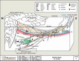
The Marañon Basin underlying the rain forest of northern Peru is the southern part of the Greater Oriente Basin,which extends into Ecuador and Colombia.Exploration in the Greater Oriente Basin over the last 25 years has resulted in the discovery of 4.5 billion barrels of oil,predominantly sourced and sealed within the Cretaceous succession.Oil generation has been prolific,and large parts of the basin exhibit complete fill of all available traps.The main reservoirs in the Marañon Basin are the basal Cretaceous Cushabatay Formation and the upper Cretaceous Chonta and Vivian sandstones. Oil is trapped in large,north-south oriented, anticlinal and faulted structures.The Marañon Basin is relatively sparsely drilled and has potential for major future discoveries.
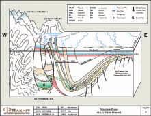
Oil generation and migration occurred in two main phases each accompanied by a hydrodynamic phase.The first (main) phase of oil expulsion culminated at c.40 Ma in Late Eocene time.Paleo-water flow strongly impacted basin-scale oil migration patterns and recharging freshwater from the east locally degraded oil quality (see Figure 1).In the second phase of oil expulsion,starting around 5 Ma and continuing at the present
day (see Figure 2) there is a well defined water circulation pattern in the Cretaceous succession.Fresh water recharges the Cushabatay and the Vivian through high-elevation outcrop belts in the Andean Foothills. The recharging fresh water flows northeastward across the central basin.In the eastern Marañon,water moves vertically upwards from the Cushabatay into the overlying sands,where the shales and tight limestones that separate these sands in the western basin wedge out.Fresh water also intrudes the basin from its eastern margin in Peru, mixing with the water flowing upward from the Cushabatay.These two water flow systems converge near the eastern basin margin in a linear zone that coincides with a major structural hinge line.The present water flow pattern impacts ‘new’ oil migration,has caused extensive re-migration of paleo-accumulations,and has created tilted oil/water contacts.
Formation water salinity patterns as well as observed tilted oil/water contacts corroborate the water circulation pattern. Formation water salinity in Cretaceous reservoirs ranges from less than 1,000 to more than 200,000 mg/L with the freshest waters in the Cushabatay and Vivian Formations adjacent to the western and southern Foothills recharge areas.The heaviest brine is located updip of the basin depocentre due to hydrodynamics.Our modeling (reviewed in this presentation) predicts oil/water contact tilts ranging from 200 ft/mile in the Foothills belts where the steepest hydraulic head gradients occur, reducing to less than 10 ft/mile in the east. Our predicted tilt directions and magnitudes are confirmed by oil/water contact tilts that are observed at major Vivian and Chonta oil fields (e.g.,Corrientes and Shiviyacu).
This presentation will review the petroleum hydrogeology of the Marañon Basin,the oil migration and tilted oil/water contact modeling we have recently conducted and will highlight some of the regions we believe have outstanding exploration potential. Selected References on Sub-Andean Basins available at www.cspg.org.
BASIN ANALYSIS DIVISION
Sequence Stratigraphy of the McMurray Formation:South Athabasca Region
Two regionally extensive unconformities dissect the McMurray Formation in the south Athabasca region.The unconformities are of high relief with deep valleys separated by interfluves. Valleys,eroded largely by fluvial processes, merge laterally with erosional surfaces formed by transgressive ravinement to form composite unconformities.Regional strata, below the unconformities,are substantially truncated on interfluves.
Estuarine/fluvial sediments infill paleo-valleys while interfluve ravinement surfaces are overlain by transgressive sands with rip-up clasts of subjacent strata.Burrows,assignable to a Glossifungites ichnofacies,penetrate the interfluve ravinement surface.The lowermost intra-McMurray erosional unconformity passes rapidly up-section into brackish water,below storm wave base,shelf sediments.Transgressive sands,above the uppermost intra-McMurray unconformity,pass upward into a thick assemblage of tidally influenced shelf strata prior to brackish shelf strata.Each brackish maximum flooding surface is succeeded by a progradational shoreline succession.
The intra-McMurray unconformities,in conjunction with the McMurray Formation bounding unconformities (pre-Mannville and Wabiskaw) define three stratigraphic sequences. The upper two sequences,delineated by the intra-McMurray unconformities and the subWabiskaw unconformity,are divisible into transgressive-regressive components separated by brackish water maximum flooding surfaces.
SEDIMENTOLOGY DIVISION
Carbonate Facies,Dolomitization, Porosity Development,and Structural Controls Within the Lower Blue Fiord Formation, Bathurst Island,Nunavut.
SPEAKER
Scott R.A.Rose Birch Mountain Resources
12:00 Noon, Wednesday,January 22,2003
2nd Floor,Suite 202, West Tower,Fifth Avenue Place 237 Fourth Avenue Place 425 - 1st Street Calgary,Alberta
The Blue Fiord Formation is a widespread carbonate unit in the Canadian Arctic Islands, which outcrops from Ellesmere Island in the east to Bathurst Island in the west.This Middle Devonian (Emsian - Eifelian) unit consists of subtidal to supratidal carbonates deposited on a wide platform shelf.
In the past,this unit has been a key stratigraphic target for oil and gas exploration because of its proximity to basinal source rocks and favourable reservoir facies.Oil was discovered within an isolated platform of Blue Fiord Formation on the southwestern corner of Cameron Island and produced ~500,000 m3 of oil from a single well (Bent Horn N-72) between 1985-1996. The discovery of sulphide mineralization (Pb-Zn) within dolomitized Blue Fiord Formation on eastern Bathurst Island in 1996 renewed mineral exploration interest within this highly prospective carbonate unit.
The lower portion of the Blue Fiord Formation on eastern Bathurst Island consists of restricted platform-interior subtidal and tidal flat facies.Early diagenetic replacement dolomite formed syndepositionally during small-scale tidal flat progradation and regressive cycles. Extensive moldic and vuggy porosity developed during early burial.Hydrothermal fluids traveled up regional basement faults during the Late Devonian Ellesmerian orogeny,causing further dissolution,collapse breccias,and precipitation of coarse replacement dolomite and dolospar cement.During the late stages of hydrothermal dolomitization sulphide min-
BIOGRAPHY
Ed Mathison received his BSc.and MSc.from the University of Saskatchewan.Prior to joining the petroleum industry he spent three years with the mineral industry,tramping through the “bush”. During the last twenty years,Ed has worked in the petroleum industry in a variety of positions in both large and small companies,and as an independent consultant.He has studied most of the foreland basin clastic succession of the Western Canada Sedimentary Basin.
INFORMATION
BASS Division talks are free.Please bring your lunch. For further information about the division,joining our mailing list,list of upcoming talks,or wishing to present a talk or lead a field trip please contact either Steve Donaldson at 403-645-5534, email:Steve.Donaldson@encana.com or Mark Caplan at 403-691-3843,email: Mark.Caplan@shell.ca or visit our web page at www.cspg.org/basin_analysis.html
erals were precipitated along regional faults and within porous facies of the Lower Blue Fiord Formation.Hydrocarbon migration occurred after dolomitization and sulphide mineralization. Later hot meteoric fluids traveled up the sameregional faults and oxidized the hydrocarbons producing pyrobitumen and blocky calcite cement that occluded moldic and vuggy porosity within facies close to fault zones.
This presentation describes an integrated stratigraphic,petrographic,and geochemical study of the Lower Blue Fiord Formation on eastern Bathurst Island and documents the stratigraphic and structural controls on early diagenetic replacement dolomitization,porosity development,hydrothermal dolomitization, sulphide mineralization,and hydrocarbon migration.
INFORMATION
Talks are free - don’t forget to bring your lunch! For more information about this talk,or about presenting a talk,please call Scott Leroux at 403-645-2419, email:Scott.Leroux@EnCana.com.
In the animal world, perspective and accuracy are often central to survival. In the oil and gas industry, understanding geophysical needs and providing accurate and timely seismic service is also vital for survival. Sigma has taken great pride in our efforts to supply you with precisely the right data for your specific needs.
In the animal world, perspective and accuracy are often central to survival. In the oil and gas industry, understanding geophysical needs and providing accurate and timely seismic service is also vital for survival. Sigma has taken great pride in our efforts to supply you with precisely the right data for your specific needs.
Sigma exercises leading edge technology in offering clients their free web-based browser SigMAP, a virtual approach to identifying and ordering Quality Inspections of seismic data.
Sigma exercises leading edge technology in offering clients their free web-based browser SigMAP, a virtual approach to identifying and ordering Quality Inspections of seismic data.
www.sigmaex.com offers real time Quality Inspections of Sigma library data using full SEG-Y images.
www.sigmaex.com offers real time Quality Inspections of Sigma library data using full SEG-Y images.
EVENT: History of Geophysics,The Geological Society
LOCATION: The Geological Society Burlington House,Piccadilly,London
INFORMATION: The History of Geology specialist group of The Geological Society,London,UK,is holding a meeting on History of Geophysics at The Geological Society Burlington House, Piccadilly,London on 12-13th March 2003.Offers of papers should be sent to the convener,Professor Richard J.Howarth,Department of Geological Sciences, University College London Gower Street London WC1E 6BT,England Email:r.howarth@ucl.ac.uk
DATE: April 6-10,2003
EVENT: SAGEEP 2003
LOCATION: San Antonio,Texas
INFORMATION: The Environmental and Engineering Geophysical Society (EEGS) invites you to submit a paper for presentation at the 2003 Symposium on the Application of Geophysics to Environmental and Engineering Problems (SAGEEP 2003).
In addition to world class oral and poster presentations on the application and recent developments in applied geophysics,there will be a suite of workshops,as well as an exhibition showcasing geophysical products and services. For more information on EEGS please visit our site at www.eegs.org.Please submit abstracts electronically to the SAGEEP 2003 Technical Chair,Cathy Skokan at cskokan@mozart.mines.edu.
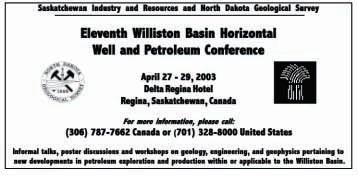
DATE: April 27-29,2003
EVENT: Eleventh Williston Basin Horizontal Well & Petroleum Conf.
LOCATION: Delta Regina Hotel,Regina,Saskatchewan,Canada
INFORMATION: Informal talks,poster discussions,and workshops on geology,engineering,and geophysics pertaining to new
developments in petroleum exploration and production within or applicable to the Williston Basin.For information call 306-787-7662 (Canada) or 701-328-8000 (US).
DATE: May 11-14,2003
EVENT: AAPG Annual Meeting
LOCATION: Salt Lake City,Utah
INFORMATION: For more information please visit www.aapg.org
DATE: June 2-6,2003
EVENT: 2003 CSPG/CSEG Annual Convention“Partners in a New Environment”
INFORMATION: For more information please contact Lori Humphrey-Clements Tel:403-264-5610
Email:lori@cspg.org
DATE: August 10-14,2003
EVENT: GeoSciEd IV:Earth Science for the Global Community
LOCATION: Calgary,Alberta
INFORMATION: The fourth international meeting for earth science teachers from elementary to university level,and for earth scientists whodeliver educational outreach programs through their communities,museums,or science centres.The purpose is to share ideas and concepts in earth science education and in the developmentof programs that lead to an integrated understanding of the Earth.The innovative technical programwill include keynote addresses,workshops,oral, and postersessions. Field trips will visit many worldrenowned sites of interest including the Rocky Mountains,the Burgess Shale,the Royal Tyrrell Museum of Paleontology,the Frank Slide,and the Athabasca Glacier.Please visit www.geoscied.org for details.
PLEASE VISIT WWW.CSPG.ORG TO DOWNLOAD OR PRINT THE MONTHLY VERSION OF THE CALENDAR OF
JACK PORTERVIGNETTES OF CANADIAN PETROLEUM GEOLOGY
Continued from December,2002
The second entrepreneurial visionary,who was to follow R.C.Fitzsimmons in the construction of a plant to extract and process bitumen from the Athabasca bituminous sand,was an American,Max Waite Ball.To many veteran workers in the oil and gas exploration industry, including myself,Max Ball was the author of a popular book,first published in 1940 by BobbsMerrill and entitled: This Fascinating Oil Business. It served as an insightful introduction,not only to those readers having a curiosity about oil and gas exploration but,in particular,to neophytes commencing their careers in the industry.Max Ball had written the text during the 1930s while residing in Edmonton,Alberta.
As an outstanding geologist and engineer,having graduated from the Colorado School of Mines in 1906,Max Ball obtained membership in the fledging American Association of Petroleum Geologists in 1919.He became vice-president of the association in 1922 and president the following year (Max Ball’s memorial,1955,by Wallace E.Pratt,Am.Assoc.Petrol.Geol.,Vol. 59,No.55,pp.775-780).Although he gained valuable geological field experience with the United States Geological Survey during his undergraduate years,as well as those immediately following graduation,he nevertheless pursued courses in law at this early period of his technical career.Max Ball earned both graduate and postgraduate degrees in law;the latter conferred in 1914.Notwithstanding,his overriding passion for geology and engineering prevailed.Throughout his varied professional occupation in the petroleum industry,including government assignments,his legal expertise became an important adjunct to his technically related tasks.
Max Ball’s introduction to the energy potential of the Athabasca bituminous sand occurred in the mid-1920s in his home city of Denver, Colorado.It was here that he was made aware of this gargantuan virgin resource through a friend and associate,“Basil Owen Jones,who cherished a surpassing faith in the ultimate worth of the Tar Sands” (Max Ball’s memorial, 1955 - p.778).Subsequently,he became alerted to the efforts of Jim McClave’s experiments to treat and separate bitumen from samples of bituminous sand.As director of Western Research Laboratories,McClave had received samples from S.C.Ells of the Dominion Mines Branch as early as 1919 (Darlene J.Comfort, 1980, The Abasand Fiasco - The rise and fall of a brave,pioneer Oil Sands extraction plant,pub. Friesen,Printers,Edmonton,p. 38).He had conducted experiments in his Denver laboratory utilizing a water flotation process,which
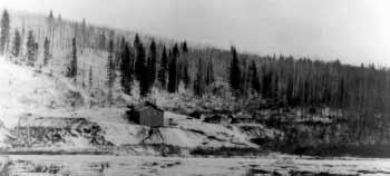
The Research Council of Alberta’s partially completed hot water extraction pilot plant,designed by Karl A.Clark and located on the bank of the Clearwater River.Photograph taken during the winter of 1929-1930.Test runs of 800 tonsof bituminous sand were processed during 1930 and 485 barrels of bitumen extracted which contained a small percentageof residual contaminants.The plant discontinued operations at years end.From left to right,in center foreground,can be seen abandon wooden derrick frame,rectangular shaped stockpile of bituminous sand,building housing pilot plant and evidence of tailings and bitumen residue on bank fronting pilot plant.Administrative and residence buildings can be viewed to the right of center.Photo credit:University of Alberta Archives.Accession no.77-128-1,Louis Romanet Collection,used with permission.
involved the introduction of a small percentage of bentonite,which acted as asolvent for separating the bitumen from its sand host.The McClave process was patented in 1923 (S.C. Ells,1926, Bituminous Sands of Nor thern Alberta, Dominion Dept.of Mines, p.186).
In 1929,Max Ball had invited S.C.Ells to visit him in Denver to discuss the commercial exploitation of the Athabasca bituminous sand.He made the trip to Denver the same year;meeting not only with Max Ball but two of the latter’s colleagues;Jim M.McClave and Basil Owen Jones.S.C.Ells,being the acknowledged authority on the Athabasca bituminous sand, eagerly conveyed to his host the knowledge he had acquired throughout his 17 consecutive field seasons spent researching these deposits.No doubt the entire gamut of factors necessary to germinate a commercially viable property was discussed.His enthusiasm was apparently so convincing that Ells suggested that a company be formed to exploit the Athabasca bituminous sand and further he entertained the proposition that he become a partner in the proposed venture (Darlene J.Comfort,1980, The Abasand Fiasco -p.36).
In 1930,S.C.Ells reciprocated by inviting Max Ball and Jim McClave to visit him in Edmonton, from where they would proceed north for a guided tour of the bituminous sand exposures in the vicinity of Fort McMurray and Waterways. The trip was such an unequivocal success that it resulted in Max Ball chartering,in September 1930,a company to exploit the deposits.The company was initially listed as Canadian Northern Oil Sand Products with headquarters in Calgary. Max Ball and his wife vacated their home in
Denver in late 1930 and took up residency in Edmonton where it was to serve as Max’s home base for future operations.
Undoubtedly,it was through the advice and lobbying efforts of S.C.Ells that the proposed plant was to be built in proximity to Horse River. This was the locale,comprising portions of sections 5 and 8,township 89,range 9,west of the 4th meridian,that he had selected to be designated,in June,1913,as a Dominion Government reservation for the National Parks Branch.In evaluating the results of a survey conducted on this reserve,Ells reports that “During the course of a somewhat detailed examination of this reserve,20 test pits were sunk through the overburden,and test borings made in the underlying bituminous sand. Analyses of 32 of these core samples indicate that in uniformity of sand aggregate and in percentage of associated bitumen,the Horse River reserve comprises one of the most promising fields in the McMurray area” (S.C.Ells, 1926, Bituminous Sands of Northern Alberta,- p.32). The mineral rights of the Horse River reserve remained vested with the Dominion Government following the transfer,in 1930, of natural resources to Alberta and other western provinces.However,these rights were subsequently transferred to Alberta in 1957.
In late 1930,Canadian Northern Oil Sand Products obtained a lease from the Dominion Government of the entire Horse River reserve comprising 581 acres.Their proposed plant was to be constructed at the north edge of the Horse River reserve block in legal subdivision 15,section 8,township 89, range 9,west of the 4th meridian.This loca-
tion,apart from its mining merits and quality of bituminous sand, possessed,as well,logistical attributes in respectto its proximity to rail and river wharfs at Waterways,including road accessibility to that terminus.
The first two years of Canadian Northern Oil Sand Products existence witnessed the continuation of laboratory research in Denver. A pilot plant,with a one ton per day separation capacity,was built in 1932 and operated by Jim McClave until 1933,at which juncture it was transported to Toronto.Max Ball’s rational for such a move was to garner interest and attendant financial support by demonstrating his separation process to potential investors. From a standpoint of procuring start-up capital for Canadian Northern Oil Sand Products,Max Ball and his partners were faced with continued disappointment.The financial ramifications following the October 1929 market crash did not bode well for available risk capital and Max Ball’s business trips to Toronto,the investment capital of Canada,had proved to be futile.
Following its only year of operation during 1930,Karl Clark’s pilot plant,installed on the bank of the Clearwater River,near Waterways, in 1929,fell dormant.Apparently,financial support for the project had been terminated by the onset of the depression with corresponding government cutbacks.The cessation of Clark’s Clearwater pilot plant operations led Ball and his associates to make an offer to purchase the plant from the Alberta Government. However,the would-be purchasers were unable to raise sufficient capital to consolidate its acquisition (Darlene J.Comfort,1980, The Abasand Fiasco - p.54).Other factors may have been conducive to the collapse of negotiations.
ROCK
To be continued in the February Reservoir.
SHOP
EARTH SCIENCE FOR THE GLOBAL COMMUNITY
GeoSciEd IV :A meeting of the International Geoscience Education Organization
August 10 – 14,2003 Calgary,Alberta,Canada
ATTENTION ALL CSPG MEMBERS HELP SPREAD THE WORD !!
Members of earth science associations and societies are very aware of the need to reach out to the public to help develop an appreciation of the earth and how its study relates to our lives.Responding to this need for public outreach has become common ground for all earth science groups regardless of specific discipline or demographic they may represent.Most,if not all,groups have declared Outreach as a priority and have struck committees and developed programs dedicated to taking an appreciation of earth science to the community.As a result,networks of earth scientists and educators have expanded around the world. Here is a great opportunity for every CSPG member to help in this vital cause.
An exciting conference,“Earth Science for the Global Community”,is coming up in 2003 in Calgary,Alberta,Canada.This is the fourth International Geoscience Education Organization (IGEO;the outreach arm of the International Union of Geological Sciences) GeoSciEd conference and is designed for Earth science teachers from elementary to university level to meet Earth scientists who deliver educational outreach programs through their communities, museums or science centres.The purpose is to share ideas and concepts in earth science education and in the development of programs that lead to an integrated understanding of the Earth.The innovative technical program will include keynote addresses,workshops,and oral and poster sessions.Field trips will visit many world-renowned sites of interest including the Rocky Mountains,the Burgess Shale,the Royal Tyrrell Museum of Palaeontology,the Frank Slide,and the Athabasca Glacier.
EVERY CSPG MEMBER CAN HELP
A huge part of the success of this conference depends on getting the word out to both
earth scientists and educators around the world.YOU can help! Take a moment to visit the conference web site (www.geoscied.org) and find a PDF version of a flyer/poster for the conference.It has been designed to be legible in black & white as well as color.Please print off some copies and give them to any teachers or geologists you know;email them the website address.Have your children take them to their science teachers.
You know that we must talk to our youth about the earth and our appreciation of it; our profession and everyone’s quality of life depends on it.Even if you can’t present a paper,which would be ideal,YOU can make a critical contribution.Please help by passing on the word of this great chance for geologists and educators to meet!
Jon S.Dudley GeoSciEd IV Publicity Chair
2003 CONVENTION - SPECIAL EVENTS
LUNCHEON SPEAKERS
Stephen Lewis
Monday June 2,2003
On June 01,2001,Stephen Lewis was appointed as Secretary-General Kofi Annan’s Special Envoy for HIV/AIDS in Africa.His mandate is to ensure follow-up to the April 2001 Africa Summit on HIV/AIDS and to the July 2001 United Nations Special Session on HIV/AIDS.Mr.Lewis’ work with the UN has shaped the past two decades of his career.From 1995 through 1999,Mr.Lewis was Deputy Executive Director of UNICEF.In 1997,in addition to his work at UNICEF,he was appointed by the OAU to a Panel of Eminent Personalities to Investigate the 1994 Genocide in Rwanda and the surrounding events.In 1993 he was coordinator for Graça Machel’s study on the “Consequences of Armed Conflict on Children.” From 1984-1988,Stephen Lewis was Canada’s Ambassador to the United Nations.As Ambassador,Mr.Lewis focused on issues of African economic recovery and climate change.He resigned the position in July 1988,but continued to act,in a personal capacity,as Special Advisor on Africa to the Secretary-General until the end of 1991.
In the 1960s and 1970s,Stephen Lewis was an elected representative to the Ontario Legislature,becoming leader of the New Democratic Party and leader of the Official Opposition.
Jeff Salz
Tuesday June 3,2003
Whether you’re leading an expedition to explore the Patagonian Ice Cap,or navigating a changing business environment,Jeff Salz,PhD,believes adopting an attitude of adventure is essential to success.This insightful explorer and cultural anthropologist defines adventure as “any intentional experience that substantially alters our perspective long enough to see things we have never before seen...or see familiar things as we have never before seen them.” In his inspiring presentation,Jeff helps audiences put the passion and commitment of adventure to work in their organizations and daily lives.
Over the past three decades,Jeff has explored and mapped the wild corners of the planet,living with the Turkestani Khazaks of Central Asia,riding with the Gauchos of Argentina and searching for Shangri-La among the lost valleys of the Himalayas.He has also spearheaded teambuilding and creativity training for high-performing Walt Disney teams,hosted many Discovery Network television specials and served as a guest expert on adventure for CBS News.
Spend time with this real-life survivor and learn how to use your own sense of adventure to turn uncertainty into opportunity in these challenging times.
2003 CSPG / CSEG Convention
Round Up Centre, Stampede Park June 2-6, 2003
SPONSOR
PROMOTE your corporate message.
ENHANCE your corporate profile by supporting the PARTNERS that you rely on. SHARE your corporate pride in the geoscience community.
SHOWCASE your knowledge, services and products in a New ENVIRONMENT. CONNECT with Canada’s largest gathering of geoscientists. UNITE in partnership with the CSPG and CSEG!
For more information on becoming a sponsor or exhibitor please visit www.cspg.org or www.cseg.ca
2003 CONVENTION - EXHIBITS
INVITATION TO EXHIBIT
The CSEG and the CSPG are pleased to invite you to exhibit at our joint 2003 CSEG/CSPG Convention - “PARTNERS in a New ENVIRONMENT”.
The 2003 Convention will be held at the Round Up Centre at Stampede Park.Exhibits will be located in Hall “D” which offers 50,000 square feet of exhibit space and is conveniently located across the hall from the technical sessions.
The 2003 Exhibit Floor will be a very busy place with all prime convention activities organized under a single roof! Special and technical events including the popular Icebreaker,Breakfast with the Exhibitors,Coffee Bars,Promotional Contests,and Poster Displays will all be held on the exhibit floor to generate and maintain delegate traffic in the exhibit area.
By exhibiting you will reach more than 3,500 delegates,representing every facet of today’s geophysical and geological community.Share your knowledge,services,and products with Canada’s largest gathering of geoscientists.
The partnership of the CSEG and CSPG for the joint 2003 Convention is a rare opportunity to present the products and services only your company can offer. They listen They learn They buy from you.
This year’s Exhibitor Committee has representatives from both large and small companies who will be exhibiting at the convention.We are committed to helping our exhibitors profit from their attendance.
Companies who had exhibits at the 2002 CSEG and CSPG conventions will be sent exhibitor packages in mid-December.If you have not received your package by the end of December
or did not exhibit last year,please contact Lori Humphrey-Clements at 403-264-5610 or the Exhibit Co-Chairs to receive a package.
John Townsley
Exhibit Co-Chair
403-770-0341
403-809-0303
John.townsley@divestco.com
Carmen Swalwell
Exhibit Co-Chair 403-269-7255
403-560-8431 carmen@lynxseismicdata.com
For more information on the Round Up Centre visit:www.stampedevenues.com
2003 CONVENTION - SPONSORSHIP OPPORTUNITIES
The 2003 CSPG/CSEG Convention is fast approaching! This year’s convention will be held at the Roundup Center at Stampede Park from June 2-6th,2003.The theme of the convention is “PARTNERS in a New ENVIRONMENT”,and we are confident that this partnership will bring a large and diverse community of delegates,exhibitors,and sponsors together in an environment that will maximize the experience for all.
Sponsorship is a vital component of a successful convention,and this year’s theme fits very well.As partners,the CSEG and CSPG look to add value to the convention experience for all our members.As a result our partnerships with the oil and gas vendors and producers are critical to our joint success.We look forward to working with both existing and new sponsors to ensure that
our valued industry partners obtain optimal sponsorship exposure.
Four main levels of sponsorship are available that will allow you to promote your company to a focused crowd of over 3,500 professionals through several activities including a golf tournament,luncheon speakers,technical sessions,and social activities.An inaugural Shareholder level will be offered to those who wish to have maximum exposure at one or all venues associated with the convention. The sponsorship levels are as follows:
Strategic Alliance$15,000+
Joint Venture$10,000+
Partnership$ 5,000+
Associate$ 2,000+
*Shareholder (limited space $25,000+ available)
We encourage all industry partners to show their support through sponsorship for this joint convention.For more information or requests please contact:
CSEG Sponsorship Co-Chair Pulse Data Inc. 403-234-6590 cherene.crawford@pulsedatainc.com
We look forward to welcoming all sponsors to the 2003 CSPG / CSEG Convention!
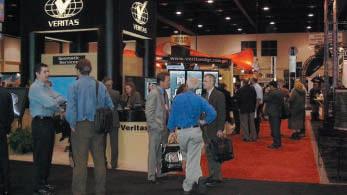
The Exhibit Hall busy with delegates during the 2002 CSEG Convention – “Taking Exploration to the Edge”. Photo courtesy of CSEG
GEOLOGICAL SURVEY OF CANADA
Is There a Basin-Wide Unconformity
Associated with the Triassic Doig to Charlie Lake Succession?
The Middle to lowermost Upper Triassic succession of the Doig,Halfway,and Charlie Lake formations consists of a series of westward prograding,offlapping,shoreline to shallow marine siliciclastic sequences (Doig and Halfway formations)overlain by interbedded mudstone, sandstone dolostone and anhydrite deposited in a peritidal (coastal plain/sabkha) environment (Charlie Lake Formation).Most recent interpretations of this succession consider the change into Charlie Lake facies to be continuous progradation from shallow marine to peritidal conditions,with no significant break in the stratigraphy.However,there have been a few dissenters against this interpretation.
If you search the literature for information about the Triassic Doig,Halfway,and lower Charlie Lake formations you will find that there is a split between those who identify an unconformity,those who interpret continuous sedimentation,and a few authors with some combination of continuous sedimentation and
BDR Consulting Ltd.
# 48 - 9520 Bonaventure Drive SE Calgary, AB Canada T2J 0E5
NHCs thermally generate, migrate and accumulate in traps?
Are created to give us energy?
Greenhouse gases cause global warming?
No to all of the above is the correct response.
To know why, contact us, and we will tell you why!
Over 30 years of research led us to the Electro-synthetic Origins of NHCs, that are rewriting Petroleum Geology (more exploration land, less risk, and much more). Four hours introduce you to what others only started to look into.
Ossama I. I. Yousif
Tel: 403.259.3635 fax: 403.253.9001 or e-mail: osyousif@telusplanet.net.
Ask about: "PETROLEUM - 685"
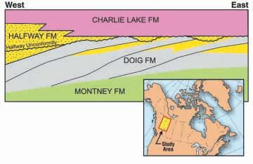
Schematic stratigraphic relationships of the Doig, Halfway and lower Charlie Lake formations,NW Alberta and adjacent NE British Columbia.Note that strata included in the Halfway Formation (yellow, stipple) occur both below and above a regional unconformity.
BY JAMES DIXON
local erosion.One of the problems associated with these interpretations is the lack of any regional work;most of the published studies deal only with local oil or gas fields,and in some instances with only a few wells.This lack of regional work was pointed out by F.G. Young (1997,p.593),after his examination of the Doig to Charlie Lake succession in the Umbach-Wargen area of northeast British Columbia.His study showed strong evidence for a major unconformity associated with the sandstone-dominant Halfway Formation,which he referred to as the “Halfway unconformity”. He concluded also that,“The Charlie Lake Formation is not necessarily a coastal plain/sabkha facies tract that prograded over and lies landward of Halfway shoreline sand facies.”
By constructing regional correlations the notion of whether or not there is a major unconformity may be better addressed.Such work has been undertaken by myself over the past few years, resulting in a series of recent publications of field-scale,map-sheet scale,and basin-scale cross sections in Alberta and northeast British Columbia (Dixon,2001,2002a,b,c).The evidence from the correlations and examination of a large number of cores throughout the basin strongly support the unconformity interpretation. Correlations,especially towards the eastern subcrop edge,show truncation of Doig horizons, where the unconformity is most commonly located at the base of a Halfway sandstone,or below the Charlie Lake Formation.Towards the west,the truncation surface commonly occurs either at the base of the Halfway sandstone,or within a thick Halfway succession. However,even in some of the western areas, there may be local occurrences of Charlie Lake facies sitting directly on Doig facies.These situations can be readily confirmed from cores
that have been cut in these various stratigraphic settings of the unconformity surface.
Why does the unconformity surface vary in its setting? This is readily explained by the erosional surface having relief and by filling in the lows on the topography with transgressive sands and overlapping the transgressive sands by Charlie Lake beds on the topographic highs. Based on the thickness of transgressive sandstones there was up to 10 m of relief especially along the eastern margin.In more basinward locations,towards the west,the truncation surface becomes more planar.This type of setting will result in locations where the transgressive sands rest either on Doig offshore facies (thinly interbedded sandstone and mudstone),or shoreline sandstone facies,or there is an absence of transgressive sands and the basal bed of the Charlie Lake Formation rests directly on Doig facies.Where transgressive sandstone rests on shoreline sandstone the total sandy interval would be the Halfway Formation.The accompanying figure schematically illustrates the stratigraphic relationships in the Doig to lower Charlie Lake succession described above.
There are some local variations in the composition of the transgressive beds.For example,in the Spirit River-Rycroft area of west-central Alberta the transgressive beds consist of coquinal dolostone.In township 75,range 5W6 there is a thick dolostone intervaloverlying the unconformity which, based on its lithology,would be classified within the Charlie Lake Formation.However, correlationsindicate that much of the dolostone is a correlative of transgressive sandstones immediately to the east and north.To
INTERNATIONAL PETRODATA LIMITED
Always Available... Always Accessible
Make Your Decisions With a Higher Degree of CONFIDENCE Make Your Decisions With a Higher Degree of CONFIDENCE
TIME - Your Most Valuable
... through the following comprehensive map based software solutions:
... through the following comprehensive map based software solutions:
Open System Solutions
Open System Solutions
QByte Services Ltd.
QByte Services Ltd.
■ Petro-LAB™ Decision Technology Corp.
■ Petro-LAB™ Decision Technology Corp.
■ Quick Select Schlumberger Information Solutions
■ Quick Select Schlumberger Information Solutions
■ PetroDesk™ international Datashare corporation
■ PetroDesk™ international Datashare corporation
■ GEOcarta™ (Capture)
■ GEOcarta™ (Capture)
Packaged System Solutions
Packaged System Solutions
IHS AccuMap
IHS AccuMap
■ AccuMap™
■ AccuMap™
■ Accu-X™ geoLOGIC systems ltd.
■ Accu-X™ geoLOGIC systems ltd.
■ geoSCOUT™
■ geoSCOUT™
Web Browser Solutions
Web Browser Solutions
Geo Webworks Inc.
Geo Webworks Inc.
■ Geo Webworks Petroleum Place
■ Geo Webworks Petroleum Place
■ DataMap™ Product Line Veritas GeoServices
■ DataMap™ Product Line Veritas GeoServices
■ GOLD
■ GOLD
THE PETRODATA FILE
THE PETRODATA FILE
Since 1963, the industry's only database that is created from original source documents; the result is the most accurate, complete and consistent database available today.
Since 1963, the industry's only database that is created from original source documents; the result is the most accurate, complete and consistent database available today.
■ General Well Data
■ General Well Data
■ Formation Tops (correlated by IPL)
■ Formation Tops (correlated by IPL)
■ Fluid Analyses (oil, gas, water)
■ Fluid Analyses (oil, gas, water)
■ Core Analyses
■ Core Analyses
■ Directional Surveys
■ Directional Surveys
■ Production/Injection
■ Production/Injection
■ Gas Well AOFP
■ Gas Well AOFP
■ Oil Well BHP
■ Oil Well BHP
■ Reserves
■ Reserves
Project Based and Special Application Business Partners
the west and south,the “normal” basal bed of the Charlie Lake Formation rests directly on the unconformity.
Does this interpretation have a practical application? A new look at exploration trends and field development are important results of the unconformity interpretation.Along the eastern subcrop edge,where the relief on the unconformity is most pronounced,the transgressive sandstones tend to be very porous and are excellent reservoirs.Also,up-dip pinch-out and overlap by impermeable Charlie Lake beds of these transgressive sandstones against topographic highs creates many of the traps seen in places such as Wembley,Grand Prairie, Progress,and Umbach-Wargen,to name but a few.
Within the Triassic of the Western Canada Basin the Halfway Unconformity can be considered to be a second-order sequence boundary. The base and top of the Triassic succession is unconformity bounded and these would be first-order events.Within the Triassic succession there are a number of basin-wide unconformities that could be considered second-order events, such as the Siphon,Boundary,and Coplin unconformities in the Charlie Lake Formation,
and the truncation associated with the Coquinal Dolomite Member of the Montney Formation. Although paleontological data from the subsurface is scarce,dating of outcrops indicate the Doig and Halfway formations to be Middle Triassic and the Charlie Lake Formation to be Late Trissic,consequently the Halfway unconformity is probably close to the Middle to Late Triassic boundary.
What lessons are there to be learned from such studies? Firstly,it is important that local studies should be placed in a regional context, otherwise erroneous interpretations can result.Secondly,lithostratigraphic terminology can be a hindrance to understanding true stratigraphic relationships especially where the location of an unconformity varies in position between the top,base or within a lithostratigraphic unit.Thirdly,correlations are affected by which datum one chooses - the wrong one can result in unusual stratigraphic correlations,leading to incorrect sedimentological and structural interpretations.
Additional work is in progress on detailed correlations in the Doig to lower Charlie Lake succession of the Grande Prairie map-sheet
Petroleum Geology
The Department of Earth Sciences at Memorial University of Newfoundland invites applications for a tenure track faculty position in petroleum geology. The successful candidate will undertake graduate and undergraduate teaching and research in the field of petroleum geology with emphasis on one or more of: sedimentology; stratigraphy; reservoir geology; and hydrocarbon exploration. Applicants will normally hold a Ph.D. in sedimentology, stratigraphy, petroleum geology or a closely related field, and have a demonstrated record of research and publication in the field of petroleum geology. A proven record of effective research work involvement with the petroleum industry would be a significant asset.
The successful candidate will join an active department of 25 faculty members with a wide range of interests relevant to petroleum geology, as well as close collaborative ties with industry and geological surveys, locally, nationally and worldwide. The department has a number of faculty members with a well established basic and applied research track record in various aspects of petroleum geology that are supported by extensive laboratory and computing facilities. Memorial University has recently committed to a new Oil and Gas Development Partnership with major new initiatives embracing broad aspects of the petroleum sector. Further information is available at http://www.mun.ca/OGDP/OGDPreport.
Applications, accompanied by a curriculum vitae, and the names of at least three referees, should be sent to Chair, Petroleum Geology Search Committee, Department of Earth Sciences, Memorial University of Newfoundland, St. John’s, Newfoundland, Canada A1B 3X5. Processing of applications will commence February 3rd, 2003, and continue until the position has been filled. Additional information is available at http://www.esd.mun.ca or by contacting Dr. Jim Wright, Head of Earth Sciences at jim.wright@mun.ca or by phone at (709) 737-2334.
Memorial University is part of a vibrant, local scientific and engineering community, which maintains an inventory of available positions that qualified partners can apply for on a competitive basis. Partners of candidates for this position are invited to include their CV for possible matching with other job opportunities.
In accordance with Canadian Immigration requirements, priority will be given to Canadian citizens and permanent residents of Canada. Memorial University is committed to employment equity and encourages applications from qualified women and men, visible minorities, aboriginal people and persons with disabilities.
BY JAMES DIXON
(83M;Twp 70-80,Rge 3-13W6) and plans for the future include extending the work into the Fort St.John area of northeast British Columbia.
REFERENCES
Dixon,J.2001. Stratigraphic setting of Middle Triassic strata in the Spirit River-Rycroft area of northwest Alberta. Geological Survey of Canada, Open File 3524,7p.
2002a. Triassic stratigraphy in the subsurface of the Trutch (94-G) map-sheet,northeast British Columbia, Central Foreland NATMAP project. Geological Survey of Canada Open File 3465 (CD)
2002b. Regional correlations within the Triassic Doig,Halfway and Lower Charlie Lake formations, Western Canada Sedimentary Basin. Geological Survey of Canada,Open File 3908 (CD)
2002c. Middle Triassic strata of the Beatton River mapsheet (94H),northeast British Columbia. Geological Survey of Canada,Open File 4204 (CD)
Young,F.G.1997. Iconoclastic view of mid-Triassic stratigraphy,Umbach-Wargen area,British Columbia.Bulletin of Canadian Petroleum Geology,v.45,p.577-594.
GNEISS N’ LITE - HUMOUR FOR THE GEOLOGIST
In past issues of Gneiss and Lite,reference has been made to ‘oxymorons’,so let us now pursue this topic some more.The English lesson for this month will be to define the word and find out a bit about its origin,and then,provide a few examples.
The World Book Dictionary defines oxymoron as “a figure of speech in which words of opposite meaning or suggestion are used together”.A couple of examples are given: ‘a cruel kindness’ and ‘a wise fool’.The word comes from the Greek ‘oxymoros’ - of which ‘oxy’ means sharp and ‘moros’ means stupid.(Any Greek scholars out there that can do a better job of this origin,please let me know.)
Unfortunately,no examples of geologically related oxymorons come to mind,but here are some others that might get a chuckle or two:
A couple of the classics would be ‘honest lawyer’ or ‘ethical attorney’ or maybe ‘honest politician’.
How about what we see every summer - the ‘hard-working outdoor city employee’?
Here’s one I recently heard - ‘freezer burn’.
Then there’s ‘accidentally on purpose’ or ‘accurate estimate’ or ‘true lies’.
How about the ‘cowardly lion’ or ‘jumbo shrimp’ or ‘bitter sweet’?
Consider:‘Irish culture’ or ‘bad sex’ or ‘pretty ugly’.
These ones don’t make much sense either: ‘random order’ or ‘unbiased opinion’ or ‘calm storm’ or ‘real phoney’.
And we can wrap this up with:‘teenage logic’ or ’management plan’.
If you can think of any with a geoscience reference,I would love to hear from you.
I mentioned in one column that I figured out why CANOXY changed its name to NEXEN - it must have been so the employees would no longer have to put up with the handle of oxymorons!! Francois Aubin went on to suggest
BY BOB ROBSON
that if MOBIL and CHEVRON were to form a merger,they could become the MORONS, which again,would let the oxy-folks off the hook.And yet another play on words - if Occidental Petroleum Co.were to drill a well in the Morrin area of Alberta,the well name would,of course,be OXY MORRIN!
Time to move on to more inspiring things!
While reading the Oct.21,2002,issue of the Daily Oil Bulletin,I spied the heading “CO2 Creep” and wondered what kind of person was being referred to.It turned out to be a reference to more and more uses of CO2 and increased atmospheric and environmental problems that could arise in the future.A story of some creature or weirdo who breathed CO2 would have caught the attention of more readers!
Now that I am at a loess for words,gangue,let me sine off by saying:“oil’s well that ends well”.Why not take a moment and jot down a few ditties of geological humor and send them in to:bob.robson@shaw.ca
Relax with Roxar
Irap RMS The leading Reservoir Modeling Software
New fault modeling- Automatic, easy to use, fast.
Heterogeneity modeling- The best in the business.
3D Grids- Robust grids for faster, accurate flow simulation.
Well planning- Accomplish in an afternoon what used to take weeks.
Workflow Management- Automates repetitive tasks and documentation.