

19 Synthetic Log Curves: An Essential Ingredient for Successful Stimulation Design 26 Go Take a Hike 30 Geo- Café – A new service for CSPG Members $10.00 MAY 2013 VOLUME 40, ISSUE 5 Canadian Publication Mail Contract – 40070050


YOUR GEOSCIENCE SOFTWARE DOESN’T HAVE TO BE ONE OF THEM IHS GEOSCIENCE: sophisticated science that’s simple to use and simple to manage SURFACE TO SUBSURFACE ONLY ONE ENERGY EXPERT PROVIDES SO MUCH TO SO MANY From big picture to critical detail, proven capabilities to superior results, IHS geoscience does it all—backed by the world’s most respected forecasting, analysis, and play-specific geological and geophysical data. NOW GET THE POWER OF KINGDOM ® AND PETRA ® Learn more at IHS.com/geoscience Only IHS geoscience simply yet scientifically links engineering, economics and interpretation software suites to give you a definitive edge. Spearheaded by industry-leading Kingdom® and Petra® software solutions IHS gives you the best in geophysics and geology. IHS GEOSCIENCE Simply Scientific™ Visit IHS at GeoConvention 2013, booth #515
YOU TACKLE TOUGH PROBLEMS
CSPG OFFICE
#110, 333 – 5th Avenue SW
Calgary, Alberta, Canada T2P 3B6
Tel: 403-264-5610
Web: www.cspg.org
Office hours: Monday to Friday, 8:30am to 4:00pm
Executive Director: Lis Bjeld
Tel: 403-513-1235, Email: lis.bjeld@cspg.org
Event Coordinator: Kristy Casebeer
Tel: 403-513-1226, Email: kristy.casebeer@cspg.org
Geoscience Coordinator: Kelsey Green
Tel: 403-513-1225, Email: kelsey.green@cspg.org
Member Services:
Tel: 403-264-5610, Email: membership@cspg.org
Publications and Website: Emma MacPherson
Email: emma.macpherson@cspg.org, Tel: 403-513-1230
GeoConvention 2014, Manager: Aileen Lozie
Tel: 403-513-1227, Email: aileen.lozie@cspg.org
Database Administrator and Accounting: Kasandra Amaro
Maternity leave until January 2014
Corporate Sponsorship: Lis Bjeld
Tel: 403-513-1235, Email: lis.bjeld@cspg.org
Controller: Eric Tang
Tel: 403-513-1232, Email: eric.tang@cspg.org
EDITORS/AUTHORS
Please submit RESERVOIR articles to the CSPG office. Submission deadline is the 23rd day of the month, two months prior to issue date. (e.g., January 23 for the March issue).
To publish an article, the CSPG requires digital copies of the document. Text should be in Microsoft Word format and illustrations should be in TIFF format at 300 dpi., at final size. For additional information on manuscript preparation, refer to the Guidelines for Authors published in the CSPG Bulletin or contact the editor.
Technical Editors
Hugh S. Mosher Colin Yeo (Assistant Tech. Editor) Nunaga Resources Ltd. Encana Corporation M.: 403-809-9997 Tel: 403-645-7724
Email: hsmosher@telus.net Email: colin.yeo@encana.com
Coordinating Editor
Emma MacPherson, Publications Coordinator, CSPG Tel: 403-513-1230, emma.macpherson@cspg.org,
ADVERTISING
Advertising inquiries should be directed to Emma MacPherson, Tel: 403-513-1230 email: emma.macpherson@cspg.org. The deadline to reserve advertising space is the 23rd day of the month, two months prior to issue date.
The RESERVOIR is published 11 times
RESERVOIR ISSUE 5 • MAY 2013 3 MAY 2013 – VOLUME 40, ISSUE 5 ARTICLES Synthetic Log Curves: An Essential Ingredient for Successful Stimulation Design .................................................................................. 19 Go Take A Hike 26 Honorary Member Of The CSPG– W.R. (Bill) May ................................................... 31 Honorary Member Of The CSPG– Andrew Miall ....................................................... 32 Geo-Café – A new service for CSPG Members 34 DEPARTMENTS Executive Comment .......................................................................................................... 5 Technical Luncheons .......................................................................................................... 8 Division Talks .................................................................................................................... 11 Rock Shop ...................................................................................................... 7, 18, 25, 34
FRONT COVER Spectacular seismic-scale folds in the Neoproterozoic Zerrissene turbidite complex of western Namibia. Photo by Paul Nicholson.
per year by the Canadian Society of Petroleum Geologists. This includes a combined issue for the months of July and August. The purpose of the RESERVOIR is to publicize the Society’s many activities and to promote the geosciences. We look for both technical and non-technical material to publish. Additional information on the RESERVOIR’s submission guidelines can be found at http://www.cspg. org/publications/pubs-reservoir-submissions.cfm. The contents of this publication may not be reproduced either in part or in full without the consent
the publisher. Additional copies
RESERVOIR
available at the CSPG
No official endorsement or sponsorship by the CSPG is implied for any advertisement, insert, or article that appears in the Reservoir unless otherwise noted. All submitted materials are reviewed by the editor. We reserve the right to edit all submissions, including letters to the Editor. Submissions must include your name, address, and membership number (if applicable). The material contained in this publication is intended for informational use only. While reasonable care has been taken, authors and the CSPG make no guarantees that any of the equations, schematics, or devices discussed will perform as expected or that they will give the desired results. Some information contained herein may be inaccurate or may vary from standard measurements. The CSPG expressly disclaims any and all liability for the acts, omissions, or conduct of any third-party user of information contained in this publication. Under no circumstances shall the CSPG and its officers, directors, employees, and agents be liable for any injury, loss, damage, or expense arising in any manner whatsoever from the acts, omissions, or conduct of any third-party user. Designed and Printed by The Data Group of Companies, Calgary, Alberta.
of
of the
are
office.


If imitation is the sincerest form of attery, we’re one attered group.
Drawing on a quarter century of oil and gas experience, geoLOGIC continues to be the market leader in data, software solutions and support. And while we lead the way, our competitors desperately create parity products, sometimes years after us. For details on how geoLOGIC leads the way, visit www.geoLOGIC.com/leader
geoSCOUT |
at www.geoLOGIC.com They can copy us. They just can’t be us.
|
|
data,
Leading the way with customer-driven
integrated software and services for your upstream decision-making needs.
gDC
gDCweb
petroCUBE


CSPG EXECUTIVE
PRESIDENT
Paul MacKay • Shale Petroleum Ltd. paul.mackay@shalepetroleum.com Tel: 403.457.3930
VICE PRESIDENT
Dale Leckie • Nexen Inc. daleleckie@nexeninc.com Tel: 403.613.0458
PAST PRESIDENT
Robin Mann • AJM Deloitte rcmann@deloitte.ca Tel: 403.648.3210
FINANCE DIRECTOR
Samantha Etherington • Barrick Energy SEtherington@barrick-energy.com Tel: 403.386.6459
ASSISTANT FINANCE DIRECTOR
Gord Stabb • Durando Resources Corp. gstabb@durando.ca Tel: 403.819.8778
PROGRAM DIRECTOR
Dave Russum • AJM Deloitte drussum@deloitte.ca Tel: 403.648.3228
ASSISTANT PROGRAM DIRECTOR
Alexis Anastas • Nexen Inc. alexis_anastas@nexeninc.com Tel: 403.699.4965
SERVICES DIRECTOR
Mike Seifert • Canadian Discovery mseifert@canadiandiscovery.com Tel: 403.269.3644
ASSISTANT SERVICES DIRECTOR
Weishan Ren • Statoil Canada Ltd. wren@statoil.com Tel: 403.724.0325
COMMUNICATIONS DIRECTOR
Curtis Evans • ERCB curtis.evans@ercb.ca Tel: 403.297.8386
ASSISTANT COMMUNICATIONS DIRECTOR
Riona Freeman • Harvest Operations Corp. riona.freeman@harvestenergy.ca Tel: 403.233.6624
OUTREACH DIRECTOR
Dawn Hodgins • Imperial Oil Resources dawn.hodgins@exxonmobil.com Tel: 403.232.5931
ASSISTANT OUTREACH DIRECTOR
Andrew Fox • MEG Energy Corp. andrew.fox@megenergy.com Tel: 403.770.5345
EXECUTIVE DIRECTOR
Lis Bjeld • CSPG lis.bjeld@cspg.org Tel: 403.513.1235
EXECUTIVE COMMENT
A message from Paul MacKay, President

This is being written at the end of the first quarter of the current executives mandate. It is a good time to pause and see if the plans that were made in the excitement of starting have taken hold. Are we on track to achieve the ambitions articulated earlier? Has reality had its go at us and where do we need to modify? In a previous comment three initiatives were stated so it might be wise to go back to those three initiatives and see how we are moving forward.
One initiative was to make us a truly Canadian society with interests across the country. This is a long term effort, which will require sustained attention and a commitment that is longer than any single term of an executive. The CSPG is a well-recognized brand. We have both national and international presence mostly due to the strong historic foundation created by generations of Canadian geologists, the technical demands of the petroleum industry, and the high quality of university education in our Canadian geology departments.
However, the CSPG can be much more than a brand. Our Society is a series of communities that come together over a common passion in geology. In many ways each technical subdivision, each conference organizing team, every effort by the Society is characterized by one consistent trait; they are created, engaged, and organized by a group of volunteers that have found commonality in a unifying interest. We have burgeoning groups of geologists across the country that exists under varying degrees of effort and struggle. It is our intention as a Society to come along side of these groups and encourage and help them to greater levels of success. In so doing, we firmly believe we will elevate the conversation in geology across the country and improve our Society.
We have begun our foray into this process with Tony Cadrin performing Ambassador duties to Atlantic Canada for the CSPG. He is in contact with numerous groups,
universities, government agencies, consultants and companies to find out how the CSPG can contribute to the local geologic community. It is the Society’s intention to place Ambassadors into all the regions across the country. This is a role that requires sustained effort, the building of relationships, and the ability to connect individuals into the CSPG. If you might be interested in volunteering for such a role in another region in Canada please contact the office with your particulars.
The second major initiative is with our Education Trust Fund. As mentioned previously, we have run a charitable trust fund for numerous years under the kind guardianship of several volunteers. If any complaint could be found with the fund is that its mandate was too small. As an executive, we ask the question “What can the ETF be?” Roger Hume has volunteered to help us find that answer by stepping up to be Chairman of the ETF. The potential of the ETF is yet to be discovered but as a charitable foundation with appreciable access to the industry, government and the membership it is only limited by our thinking and willingness to engage. The ETF will be the subject of future comments but should you have interest in this adventure I urge you to contact the CSPG office.
The Society is the intellectual home for many of us when discussing geology. The Society’s mandate is disseminate technical knowledge in geology, particularly pertaining to or about petroleum geology, to the broader Canadian community. We do this through our meetings and publications. Given this mandate we have a few non-negotiable tasks that we must do to be able to meet this mandate. The Bulletin is our peer-reviewed journal and has historically received recognition as a quality publication. Numerous scientific publications are in a struggle as they balance the need to protect the peer-review process but also adjust to the rapidly changing landscape associated with web publication. (Continued on page 7...)
RESERVOIR ISSUE 5 • MAY 2013 5 Please Call The Office!


Pump Up the Volume
Maximize your recovery with domain expertise
CGG offers a complete portfolio of geological and geophysical technology and services to ‘pump up the volume’ on your field development.
A global network of experts in our subsurface imaging, Jason, Robertson, and Hampson-Russell software, services and consulting teams have unique technology and extensive knowledge in the basins where you work. Together we can provide you with a multi-disciplinary approach that enables a deeper understanding of your reservoir.
• Advanced subsurface imaging
• Solution-oriented reservoir characterization software and services
• Wellsite services providing real-time geological analysis
• Permanent reservoir monitoring and 4D seismic services
• Economic evaluation and recovery factor analysis consulting
We are CGG.


cgg.com
CORPORATE SPONSORS
DIAMO ND
GeoLOGIC Systems Ltd.
PLATI N UM
APEGA
Cenovus Energy
ConocoPhilips Canada
Nexen GOLD
Devon Energy Corp.
IHS
Imperial Oil Ltd.
PLS
Shell Canada Limited
Statoil
SILVER
Arc Resources
Athabasca Oil Corporation
CNRL
CSEG Foundation
CSPG Educational Trust Fund
Encana Corporation
Enerplus
EOG Resources
LED Signs
MEG Energy Corp.
Roke Technologies Ltd.
TAQA North Ltd.
BRO NZ E
AGAT Laboratories
Apache Canada
Husky Energy Inc.
Loring Tarcore
Poggenpohl
RIGSAT Communications
RPS Energy
Schlumberger Canada Limited
Sensor Geophysical Ltd.
Suncor Energy
Talisman Energy
As of April 2013
A Special Thanks to Geologic Systems Ltd.,
C SPG ’s Top Sponsor of the Month (...Continued
In a world that demands access to the latest research our editors balance the careful review process with the must have now attitude of the internet. There is much we can do to help this process but the greatest contribution the membership can make to the Bulletin is to use it as a means of research and as a vehicle for publication. Our editors (both past and present) are dedicated to the Bulletin and invest significant time and effort. Our Society is filled with geologists that make daily contributions to the Science of Geology. Consider publication in the Bulletin or better yet draw a group of like-minded colleagues and consider a special issue of the Bulletin. This executive is firmly committed to the publication of the Bulletin, please let us know how we can deliver this to you in an effective helpful manner by calling the office.
Our Annual Joint Convention with our sister societies (CSEG and CWLS) is the showcase event for us and one of the primary methods we have of meeting our mandate and also funding the ongoing work of the Society and the ETF. We are dependent on the success of the convention on many different levels. Success at the convention gives the rest of the Society’s activities a kick start. Stability of the Convention from year-to-year gives stability to the Society. The Convention is a multi-million dollar event that is dependent on a number of volunteers and a few staff for direction, organization, implementation, execution, and evaluation. Over the years we can track ebbs and flows in the success of the Convention. There are likely many factors that go into the success of any given Convention but we want to make sure that we carry on with new ideas that show promise and don’t repeat obvious mistakes.
The desire of the CSPG is to bring structural
stability to the Convention. To do this we have formed a Limited Partnership with the CSEG and the CWLS. This structure will place operation of the Convention into the partnership’s structure, to be called GeoConvention. This structure will have its own Board of Director’s, staff, and strategic plan. We will not lose any control over the convention but we should see greater stability in the business of the Convention. Our hope is that revenue will improve from the Convention by increased attendance, better consistency from year-to-year, greater demand on the Exhibit Floor, and an effective long-term marketing strategy. The Convention has incredible potential; these changes are designed to mine that potential.
How will we know if we are successful on these ventures? The best gauges we have for success are the comments and involvement of the membership. When we are meeting our mandate our membership increases, our volunteers become more involved and our finances improve. It may take time to see the results but this executive firmly believes that the changes taking place will result in a more dynamic and effective Society for our members.
We are one quarter of the way through the year and have launched all of these initiatives on a strong first step. How well they do depends on how well the membership supports these efforts. The good news on these initiatives is that they are all spearheaded by volunteers who are passionate about their Society and their Science. It is a wonderful group to be part of and it is a group where enthusiasm and ability mix. If you think this might be something you would like to become involved with or simply know more about I urge you to call the office. I believe that request has been stated four times in this comment –please call, we are waiting.
ROCK SHOP
RESERVOIR ISSUE 5 • MAY 2013 7
from page 5)
TECHNICAL LUNCHEONS MAY LUNCHEON
Hondo evaporites within the Grosmont Heavy Oil Carbonate Platform, Alberta, Canada
SPEAKER
M ary L uz Bor rero
11:30 am
T hurs day, M ay 23, 2013
C alga ry, TE L US C onvent ion C entre
E xhibit H all E , N orth B uilding
C algary, A lber ta
Please note: The cut-off date for ticket sales is 1:00 pm, Thursday, May 16, 2013. CSPG
Member Ticket Price: $45.00 + GST NonMember Ticket Price: $47.50 + GST
Each CSPG Technical Luncheon is 1 APEGA PDH credit. Tickets may be purchased online at www.cspg.org.
ABSTRACT
Advances in thermal recovery technologies have made the unconventional resources in the Grosmont carbonate platform a focus of interest in the last couple of years. The Grosmont platform which includes the Grosmont Formation and the Hondo evaporites is part of the Woodbend Group, the world’s largest heavy oil deposit hosted in carbonates with an estimated 318 to 406 billion barrels of oil in place. A detailed log interpretation, core examination; facies
GEOEDGES INC.
Detailed and accurate geology at your fingertips in Petra, GeoGraphix, ArcGIS, AccuMap, GeoScout and other applications
Western Canada Geological Edge Set
Eastern US / Appalachian Basin Geological Edge Set
Northern US Rockies & Williston Basin Geological Edge Set
North American Shales Geological Edge Set
Texas & Midcontinent US Geological Edge Set
Webcasts sponsored by

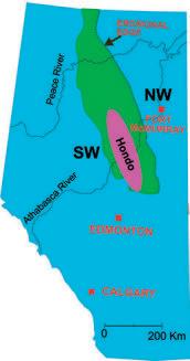
description; strontium, sulphur, carbon, and oxygen isotope analysis were carried out in the present research. Underlain the Grosmont platform there are the Leduc-age reef complexes, deposited during the major late-Frasnian regression in the Western Canada Sedimentary Basin. Significant accumulations of “heavy oil” and bitumen occur in east-central Alberta at depths of 250 m to approximately 1200 m within the updip-pinchout of the Devonian Woodbend Group with the overlying Sub-Cretaceous unconformity (Figure 1).
The Grosmont shelf complex represents an overall shallow marine carbonate platform that is further subdivided into four shallowing-upward cycles: Lower Grosmont (LGM), Upper Grosmont1 (UGM1), Upper Grosmont2 (UGM2), and Upper Grosmont3 (UGM3). These units are separated by layers of marl of the Lower Ireton Formation that are named consecutively SB1, SB2, and SB3, and can be identified on gamma ray and resistivity well logs. The Hondo evaporites is an evaporitic sub-unit within the Grosmont and replaces part of the four cycles in certain portions of the complex. Depositional setting has been interpreted mostly as marine
for information contact: Joel Harding at 403 870 8122 email joelharding@geoedges.com www.geoedges.com
Western Canada: Slave Point, Swan Hills, Leduc, Grosmont, Jean Marie, Horn River Shales, Elkton, Shunda, Pekisko, Banff, Mississippian subcrops and anhydrite barriers in SE Sask., Bakken, Three Forks, Montney, Halfway, Charlie Lake, Rock Creek, Shaunavon, BQ/Gething, Bluesky, Glauconitic, Lloyd, Sparky, Colony, Viking, Cardium, Horseshoe Canyon and Mannville CBM, Oilsands Areas, Outcrops
US Rockies & Williston: Red River, Mississippian subcrops & anhydrite barriers (Bluell, Sherwood, Rival, etc), Bakken, Three Forks, Cutbank, Sunburst, Tyler, Heath, Muddy, Dakota, Sussex, Shannon, Parkman, Almond, Lewis, Frontier, Niobrara, Mesaverde shorelines, Minnelusa, Gothic, Hovenweep, Ismay, Desert Creek, Field Outlines, Outcrops
Texas & Midcontinent: Permian Basin paleogeography (Wolfcampian, Leonardian, Guadalupian), Granite Wash, Mississippian Horizontal Play, Chat, Red Fork, Morrow, Sligo/Edwards Reefs, Salt Basins, Frio, Yegua, Wilcox, Eagleford, Tuscaloosa, Haynesville, Fayeteville-Caney, Woodford, Field Outlines, Outcrops, Structures
North American Shales: Shale plays characterized by O&G fields, formation limit, outcrop, subcrop, structure, isopach, maturity, stratigraphic cross-sections. Includes: Marcellus, Rhinestreet, Huron, New Albany, Antrim, Utica-Collingwood, Barnett, Eagleford, Niobrara, Gothic, Hovenweep, Mowry, Bakken, Three Forks, Monterey, Montney, Horn River, Colorado
Eastern US / Appalachia: PreCambrian, Trenton, Utica-Collingwood, Medina-Clinton, Tuscarora, Marcellus, Onondaga Structure, Geneseo, Huron, Antrim, New Albny, Rhinestreet, Sonyea, Cleveland, Venango, Bradford, Elk, Berea, Weir, Big Injun, Formation limits, Outcrops, Allegheny Thrust, Cincinatti Arch, Field outlines
Deliverables include:
-Shapefiles and AccuMap map features
-hard copy maps, manual, pdf cross-sections
-Petra Thematic Map projects, GeoGraphix projects, ArcView map and layers files -bi-annual updates and additions to mapping -technical support
8 RESERVOIR ISSUE 5 • MAY 2013
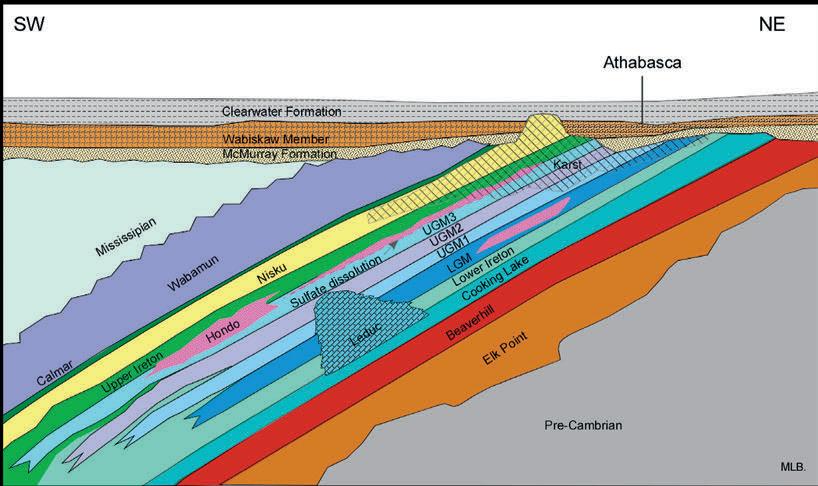
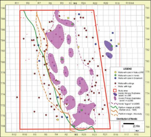
sourced gypsum/anhydrite with some halite in subaqueous salinas or lagoons. Fine layers of dolomudstone were deposited with the evaporites in quiet waters at depths between 2 and 5m. The evaporites or “primary sulphates” were observed within the upper part of the Grosmont Formation (UGM3) and Lower Grosmont (LGM) and are interpreted to occur either in a series of relatively small ponds or in a larger lagoon (Figure 2). Syndepositional faulting and presence of Leduc reefs may have been responsible for restricted conditions and accommodation space in order to precipitate evaporitic minerals. The Grosmont Platform migrated westward between LGM and UGM3 times.
In the eastern part of the area, the Hondo appears to have been dissolved and replaced by solution collapse breccias and “bitumen supported” intervals. Alternatively, in the western part of the study area the Hondo may form effective reservoir seals on the scale of the sizes of these ponds. The role of the Hondo as a seal for hydrocarbon migration and entrapment is somehow difficult to assess because it cannot be ascertained whether the evaporitic minerals originally formed a regionally extensive deposit on the scale of the entire study area, and how much was removed by post-depositional dissolution. Possible modern analogs in terms of climatic conditions are the Abu Dhabi region in the southern part of the Arabian Gulf and the Great Bahama Bank in terms of the size of the carbonate platform, although without actual evaporitic deposition.
BIOGR APH Y
Mary Luz Borrero received her B.Sc. (Honours) degree in Geology from the Universidad
Industrial de Santander, in Colombia, South America. This was followed by a couple of years of oil and gas research at the Instituto Colombiano Del Petroleo in Bucaramanga. In 2006 Mary came to Canada with a partial scholarship from Colombia –Colfuturo and was lured to the University of Alberta by Dr. Hans Machel to work on the evaporitic unit in the Grosmont Complex. While finishing her thesis, Mary continued to do research with Dr. Machel
at the University of Alberta. In 2012, her M.Sc thesis “Hondo Evaporites within the Grosmont Heavy Oil Carbonate Platform, Alberta, Canada” was awarded as the best MSc. thesis by the CSPG. This thesis was partly funded by Shell Exploration & Production Company, Houston, where she worked during some summer times. Nowadays, Mary is working for Husky Energy as an exploration geologist in the Western Canada Sedimentary Basin.
RESERVOIR ISSUE 5 • MAY 2013 9
Figure 1. Map of the Grosmont Platform and Hondo “evaporites” (modified from Switzer et al., 1994); schematic stratigraphic cross section through the region (some concepts taken from Cuttler, 1983 and Dembicki and Machel, 1996).
Figure 2. Geometry and distribution of the Hondo primary sulphates.
Five Great Days of the Finest Geoscience Training for One Low Price
• Reservoir Engineering for Petroleum Geologists
• Rocks, Pores & Capillary Pressure: Understanding Reservoirs & Seals
• Getting Started in Fluvial Stratigraphy
• Fundamentals of Siliciclastic Sequence Stratigraphy
• Introduction to Geosteering Concepts & Procedures
• Pore Pressure Prediction in Practice
• Essentials of Subsurface Contouring—By Hand or By Computer
• Seismic Interpretation in Fold-and-Thrust Belts Using Fault-Related Folding Techniques
• Risk Reduction for Plays & Prospects Using Quantitative Show
• Seismic Geomorphology & Seismic Stratigraphy
• Exploring for Stratigraphic Traps Using Multi-well Pressure/Depth Plots
Hosted by the Norris Conference Center: 304 Houston St. Ft. Worth, TX 76102
Phone: 817-289-2400 Fax: 817-289-2411
Special AAPG group rates at nearby hotels.
Registration and information:
Toll-free (U.S. and Canada) 888-338-3387, or 918-560-2650 Fax: 918-560-2678
E-mail: educate@aapg.org
Download a registration form at: www.aapg.org/education/sec.cfm
include:
Courses
Tuition for the week: AAPG Members..........................$1795 $1995 Non Members............................$2095 $2295 Individual Courses....................$500/day $550/day
SIGN UP NOW!
concurrent sessions each day – mix and match according to your interests and training needs. Buffet Lunch and refreshments included each day.) SUMMER EDUCATION CONFERENCE BY BECOMING AN AAPG MEMBER AND/OR REGISTERING BEFORE MAY 13 TH 3 rd ANNUAL FORT WORTH, TX • JUNE 10-14, 2013 Price increase after 5/13/2013 Price through 5/13/2013 SAVE up t o $ 500
(Four
(Your five-day badge can be transferred to a friend or colleague if you can't attend all five days.)
DIVISION TALKS SUMMARIES,
JA N UARY
EN VIR ON ME N TAL
DI VI S IO N TALK
S UMMARY
On January 25th, 2013 the Environmental Technical Division of the CSPG hosted David Bethune of the University of Calgary to speak about a Canadian nonprofit organization called ‘Hydrogeologists Without Borders’ (HWB) . ‘Hydrogeologists Without Borders’ was formed in Calgary in 2005 and became a registered Canadian charity in 2010. The group’s main focus is to apply the principles of hydrogeology to groundwater management in developing countries. By using science, education, and awareness about the water cycle, water wells can be developed and sustained for the benefit of the local community. HWB is working toward strengthening connections between hydrogeologists and the international development community. Mr. Bethune emphasized the importance of creating a set of best practices on
how to sustainably develop groundwater resources. The ultimate goal of HWB is to make these best practices available to other charitable organizations engaged in water well drilling. HWB also provides scholarships to hydrogeology graduate students in programs based in developing countries. If you missed Mr. Bethune’s presentation but are interested in learning more about ‘Hydrogeologists Without Borders’ take a look at their website at www.hydrogeologistswithoutborders.org.
FE B RUARY
STRUC TURAL DIVI S IO N TALK
S UMMARY
On February 7th, 2013 the Structural Division of the CSPG welcomed Dr Robert Godfrey of Schlumberger, who gave a lunch-time lecture on ‘Seismic Detection of Subtle Faults and Fractures’ He presented a review of the anttracking program, which was developed
by Schlumberger in Stavanger and is commercially available in Petrel. This program emulates the behavior of ant colonies in nature, and uses virtual ants to extract fracture and fault patterns from a seismic attributes cube. Ant tracking is particular useful for mapping fracture corridors, which can act as a conduit or barrier to fluid flow. The results can be used to build a discrete fracture network (DFN) model, which can then be upscaled and used for reservoir simulations in naturally fractured reservoirs. Examples were given from the Athabasca Oil Sands and North Africa, and some outcrop analogues were shown. Robert explained how this workflow greatly reduced the uncertainty of predicting and modeling fracture networks. If you missed this talk but are interested in the Structural Technical Division of the CSPG go to www.cspg.org to find out when the next division talk will be held.
(Continued on page 12...)


RESERVOIR ISSUE 5 • MAY 2013 11
Canadian Discovery Ltd. www.canadiandiscovery.com Visit us at GeoConvention: Integration, booth #402 Discover how our unique blend of geology, geophysics and geomechanics provides fully-integrated solutions for subsurface characterization. Geoscience Consulting | Multi-Client Studies | Information Products | Completions & Frac Data
AND FEBRUARY 2013 Sponsored by
JANUARY
ADVERTISE IN TH E
RESERVOIR
Please call:
Emma MacPherson
Tel:403.513.1230
Email:emma.macpherson@cspg.org

(...Continued from page 11)
FE B RUARY IN TER N ATI ONAL DIV IS IO N TAL K
SUMMA RY
On February 13th, 2013 the International Technical Division of the CSPG welcomed Dr. Easton Wren to speak about his company’s work in the Neuquén Basin of Argentina. Dr. Wren began by explaining the characteristics of the Neuquén Basin and how it deepens to the west against the Andes and contains two prospective shale units: the Vaca Muerta and the Molles Shale. Dr. Wren focused on the late Jurassic – early Cretaceous in age Vaca Muerta shale that is estimated to cover an area of 8,500 square miles. This shale varies in depth between 5,500 and 4,000 feet, but what makes it so prospective is that it can be up to 2,000 feet thick. This shale is overpressured and has been compared to the well-known North American Eagle Ford, Haynesville, Bakken and Horn River shale plays. One unique difference between the Vaca Muerta shale and these other North American shale plays is the types of wells used in production. The Vaca Muerta shale is so thick that vertically drilled wells are sufficient to produce the shale. Dr. Wren also described the difficulties that are often encountered when exploring internationally in undeveloped areas. A primary difficulty in these areas is the limited availability and quality of data sources; a problem which is almost unheard of in the Western Canadian Sedimentary Basin. If you missed this talk and would like to learn more about the International Technical Division of the CSPG visit www.cspg.org to find out when the next division talk will be held.
12 RESERVOIR ISSUE 5 • MAY 2013
more than 3000 petroleum professionals who are empowered to purchase your product or service.
Reach
PETROLEUM INDUSTRY COURSES
 Photo by: Bill Ayrton
WHO SHOULD ATTEND
New geologists, engineers, geophysicists and landmen, as well as summer students entering the industr y for the first time will find the courses a very beneficial introduction to the petroleu m industry . These courses will be extremely useful to nonprofessional and support staff in the oil and gas industry, as w ell as accountants, lawyers, brokerage and financial personnel working primarily alongside the oil and gas industry.
TO REGISTER
To register or to obtain additional information regarding in-house and upcoming courses, please contact:
Ayrton Exploration Consulting Ltd.
Tel: (403) 262-5440
Email: ayrtonex@shaw.c a
Or visit our website: www.ayrtonexploration.com
OVERVIEW OF THE OIL & GAS INDUSTRY IN WESTERN CANADA
Date: May 1st and 2nd, 2013
Cost: $1050 (includes GST)
Instructor: Bill Ayrton
Effective for personnel just joining the oil patch, or for financial, accounting, and information systems personnel.
• Learn about the many facets of the industry.
• Oil finding, land acquisition, drilling, seismic, well completion, jargon and terminology.
GEOLOGY FOR NON-GEOLOGISTS
Date: May 15th and 16th, 2013
Cost: $1050 (includes GST)
Instructor: Bill Ayrton
Effective for geological technicians or administrative staff, or for those who just want a better understanding of geology to appreciate the world around us.
• Learn about earth structure, geologic time-scale and processes, Western Canada geology, and interesting nearby locations.
• Participate in a r ock identification exercise , cross-section project and a mini-field trip in downtown Calgary.
GEOLOGY OF THE WESTERN CANADIAN SEDIMENTARY BASIN
Date: June 4th, 5th, and 6th, 2013
Cost: $1575 (includes GST)
Instructor: Bill Ayrton
Ideal for those who wish to improve their geological understanding of where and how we look for oil and gas fields in Western Canada.
• To visualize what Western Canada looked like throughout the stages of history, for example, the position of the sea versus land, what sediments were deposited, and what type of life that existed and evolved.
• To review the importance of each major stratigraphic unit, i.e. Devonian, Mississippian, Cretaceous, etc.
• Discuss the geological and seismic expression of typical oil and gas fields in each unit.
technology • seismic • rocks • maps • formations • land • sediments • history • sea • fossils • environment
GE OLOG Y FO R NON- GE OLOG ISTS Pr esen ted by W.G. ( Bi ll) A yr to n
ENRICHED
Interpreting and Modeling
Geology, Geophysics, Petrophysics
DEEPER INSIGHT INTO THE SUBSURFACE TO MEET YOUR E&P CHALLENGES
With Paradigm, interpretation isn’t just a step in the process; it is the process. Modeling is an integral part of interpretation, with geology, geophysics and petrophysics combined and energized by a new user interface. This leads your team to trade linear thinking for dynamic collaboration, increasing productivity with no compromise in quality. The result? Greater confidence in your E&P business decisions.
Get enriched results. Find out how at pdgm.com

Less time, higher accuracy: A unified interpretation and shared earth model.

14 RESERVOIR ISSUE 5 • MAY 2013
Visit Us at Booth 219 at GeoConvention 2013 in Calgary
DIVISION TALKS STRUCTURAL DIVISION
Natural fracture patterns in the Alberta Basin: Don’t
forget the basement!
SPEAKER
Dr. Henry Lyats ky, P.Geoph., P.Geol. Lyatsky Geoscience Research & Consulting Ltd.
12:00 Noon, Thurs day, M ay 2, 2013 Confere nce Centre Room A , +30 level, Western C anadian Place (Husky E nerg y), 707-8th Avenue S.W. C algar y, A lbert a
ABSTRACT
Brittle faults and fractures in the cratonic crystalline basement commonly propagate up into the overlying sedimentary section, including in the Alberta and Williston basins. This phenomenon was described in Europe in the 1920s and the same concept has been applied in Alberta since Leduc. With or even without big vertical offsets, basement faults and fractures affect patterns of deposition, erosion, compaction, alteration and salt dissolution, as well as the development of primary and secondary porosity including fracture porosity.
Basement faults and fractures in western Canada commonly have too little offset to be resolvable with seismic data, but many of them appear as subtle linear anomalies in

gravity and magnetic maps. Major anomalies, by contrast, tend to be associated with orogenic basement structures which are ductile and thus of less influence on the sedimentary basins. In much of western Canada, adequate gravity and magnetic data are available in the public domain at zero cost from government sources.
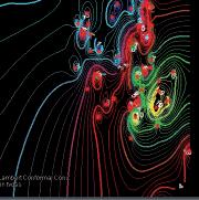
These data are processed to highlight the hard-to-detect lineaments that could be related to brittle fault and fracture networks. The most fruitful techniques tend to be the most intuitive and the simplest: horizontal and vertical derivatives, shadowgrams, amplitude gain, third-order residuals. Complex processing methods are best avoided in order to maintain a clear connection between derivative anomalies and original raw ones, to prevent the appearance of a mathematically baffling and dodgy “black box,” and to avoid creating lineament-like processing artifacts.
Lineaments are picked in the derivative gravity and magnetic maps by hand. A lineament could be a gradient zone, a linear break in the main anomaly pattern, a straight anomaly, an alignment of small local anomalies, or some combination of the above – in short, without prejudice, anything in a map that seems linear. Identified lineaments may not all be fault and fracture zones, and some real faults and fractures may have no discernible gravity and magnetic signatures.
The picked lineaments should be compared with surface topography and drainage patterns and, above all, with subsurface geological and seismic information. Correlations of linear reservoir trends and other Phanerozoic
Sponsored by
geologic features with gravity and magnetic lineaments may point to control by basement fractures and faults.
BIOGRA PH Y
Henr y Lyatsky is a Calgary-based geophysical and geological consultant who has worked across Canada, northern and western U.S., and internationally in oil and mineral exploration.
He was born in St. Petersburg, Russia and moved to Calgary as a teenager. He holds a B.Sc. in geology and geophysics (1985, University of Calgary), an M.Sc. in geophysics (1988, University of Calgary) and a Ph.D. in geology (1992, University of British Columbia). He is the first or sole author of three books (SpringerVerlag) on the regional geology and geophysics of western Canada, two gravity and magnetic atlases of the Alberta Basin (Alberta Geological Survey) and many papers. He is a member of CSEG, MEG and APEGA.
Henry is a past president of the Mineral Exploration Group, a province-wide miningindustry association in Alberta. To avoid the downtown rat-race and congestion, he works from home, enjoys the free space of the Alberta outdoors, and loves nothing better than in-depth history books and good hikes in the mountains.
DIVISION INFOR MATION
Structural Division talks are monthly and cover a diversity of structural themes. Our Structural Division sponsors are HEF Petrophysical and Husky Energy. All are welcome and no registration is required. For additional information, to be placed on the Division e-mail list or to present a talk, please contact Darcie Greggs, Darcie. Greggs@huskyenergy.com.i


With reservoirs becoming increasingly complex, you need the most accurate information you can get to better understand your reservoir.
Weatherford Labs helps you get more from your core by combining an unsurpassed global team of geoscientists, engineers, technicians and researchers with the industry’s most comprehensive, integrated laboratory services worldwide. From core analysis, sorption, geochemistry and isotopic composition to detailed basin modeling and comprehensive data packages, we provide you with real reservoir rock and fluid information that hasn’t been distilled by a simulator or iterated by software.


We call it “The Ground Truth™” – giving you the accurate answers you need for better reservoir understanding. You’ll call it a better return on your reservoir investment. To learn more, contact TheGroundTruth@weatherfordlabs.com
RESERVOIR ISSUE 5 • MAY 2013 15
Get
from your
weatherfordlabs.com © 2013 Weatherford. All rights reserved. Incorporates proprietary and patented Weatherford technology.
More
Core

WANT TO TRANSCEND THE NORMAL BOUNDARIES OF YOUR WORKFLOW?

Give your productivity a lift with outstanding connectivity and an intuitive interface.
Petrosys software provides freedom to move between data sources effortlessly, access a broad range of data management capabilities and effectively model the subsurface. With our dynamic data aggregation and integration, you can identify, refine and resolve issues more quickly. What’s more, our clear, logical interface makes it easy to get started. Of course, there’s dedicated technical support and service when needed. Start achieving exploration and production targets at a lower cost and in a shorter time frame with Petrosys. Learn more at www.petrosys.com.au/transcend

MORE THAN MAPPING SOFTWARE SERVICES CONNECTIVITY DATA MANAGEMENT
DIVISION TALKS GEOMODELING DIVISION
Quantitative seismic interpretation –An earth modeling perspective
SPEAKER
Damien Thenin
RP S, Calgary, AB, Canada TheninD@rpsgroup.com
12:00 Noon
Wednesday, M ay 29, 2 013 L ocat ion: TBA
AB STRAC T
Eart h models are routinely used in the oil and gas industry to integrate multidisciplinary data and to predict the subsurface conditions. While most earth models predict reasonably well at the field scale, they often fail to accurately predict the subsurface conditions at a specific location, especially in stratigraphically complex reservoirs.
Several advanced 3D seismic interpretation workflows are available to create more reliable earth models: inversions, seismic stratigraphy and geomorphology amongst others. But these workflows are often used as standalone projects. In addition a common pitfall for interpreters is to go from a qualitative to a quantitative interpretation without accounting for the workflows assumptions and limitations.
The purpose of this presentation is to review the different ways of integrating advanced 3D seismic interpretation results to better constrain an earth model (from pre and post-stack inversions, to seismic stratigraphy and geomorphology). Various examples will be used to discuss pitfalls and practical solutions for a successful quantitative seismic interpretation. Particular attention will be paid to the use of local geostatistics to integrate 3D seismic data into an earth model.
BIOGR APH Y
Damien Thenin graduated from the Nancy School of Geology in France in 2003 with a Master degree of Engineering and Earth Sciences. During his three years in Nancy he specialized in Petroleum Geology and worked on geomodeling projects with the GOCAD Research
Sponsored by
Group. Damien previously worked with Earth Decision and Paradigm in the Middle East and Canada. He joined Boyd PetroSearch in 2008 (now part of RPS) to launch and develop a new Earth Modeling Division, providing geomodeling consulting services with GOCAD, SKUA and Petrel in the oil and gas, mining and gas storage industries. Damien has more than 10 years of geomodeling experience. He worked on a variety of conventional and unconventional resource plays in North America, South America, Middle East, Asia and West Africa.
DIVISION I NFOR MATION:
There is no charge for the division talk and we welcome non-members of the CSPG. Please bring your lunch. For details or to present a talk in the future, please contact Weishan Ren at (403) 724-0325, e-mail: wren@statoil.com.
RESERVOIR ISSUE 5 • MAY 2013 17
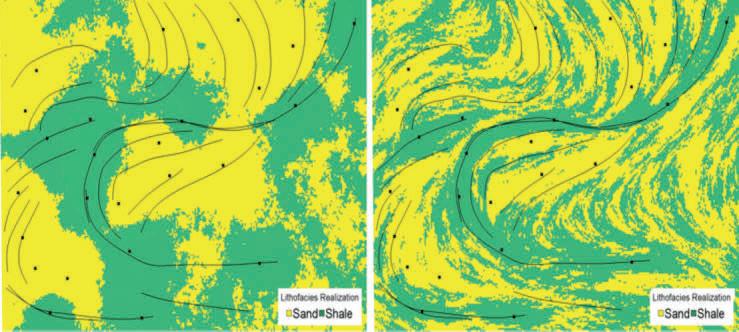
Map of lithofacies simulated from well data (black squares) with a single variogram model (left) versus a locally varying variogram model (right) derived from trends interpreted from seismic geomorphology (black lines): by integrating soft data extracted from 3D seismic, fluvial channel deposits are simulated with a greater geological realism.
ROCK SHOP


18 RESERVOIR ISSUE 5 • MAY 2013
Domestic and International Conventional Vertical and Horizontal Wells Oil Sands - SAGD/Coring Programs Shale Gas/Oil Shales Coal Bed Methane Project Supervision Email: progeo@telus.net Tel: (403) 262-9229 Fax: (403) 265-0377 Website: www.progeoconsultants.com petrographical & sedimentological descriptions for samples (thin section - fluid inclusion studies) conventional vertical/horizontal wells operations geology SPECIALIZED IN GEOLOGICAL WELLSITE SUPERVISION AND CORE ANALYSIS RockWell
our best friend and most valuable partner is our client Stephan C. Dragomir president www .g e ok2. c om - phon e: 403.831.9941 - s dr a gomir@geok2.com 1602 – 5th St N.E. Calgary, AB. T2E 7W3 Phone: 403-233-7729 www.tihconsulting.com e-mail: tih@shaw.ca T.I.H. Consulting Ltd. Geologic Well-Site Supervision *Domestic & International Supervision 906, 505 6 St. SW Calgary, AB T2P-1X5 Jocelyn Lampron, P. Geol. President & CEO Wellsite Geological Supervision *Conventional Wells-Heavy Oil/SAGD *Coal Bed Methane Wells www.hopewellpetroleum.com info@hopewellpetroleum.com section ph: 403.266.3132 cell: 403.818.8549 *On & Offshore Geological Supervision Opus Training Group 403 720-9810 www.opustraininggroup.com Geology Training for the Petroleum Industry Wellsite 101 (The name that says it all!!!) Bus 403.234.7625 800, 555 - 4 th Avenue SW, Calgary, AB, T2P 3E7 info@WellsiteGeologists.com www.WellsiteGeologists.com
Consulting
SY NTHETIC LOG CURVES: An Essential Ingredient for Successful Stimulation Design
| By E. R. (Ross) Crain, P.Eng. and Dorian Holgate, P.Geol.
INTRODUCTION
Good quality sonic and density log data are required for calculating a petrophysical analysis for reservoir description, or for determining elastic properties of rocks for stimulation design, or for seismic modeling. Rough borehole conditions and gas effect are the most common problems that will need to be repaired.
Log editing to repair problem data goes by several names: log repair, log reconstruction, or log modeling. We can also create missing log curves by the same reconstruction methods. Some calibration data may be required from offset wells to do this reliably. The reconstructed logs are often called synthetic logs, to distinguish them from the original measured data set.
Reconstruction techniques are not newthey have been with us since the beginning of computer aided log analysis in the early 1970’s and some primitive methods date back to the 1940’s. The problem is that few people understand the need for the work or are unfamiliar with appropriate techniques.
Exactly what you do to reconstruct the log data will depend on what you want to do with that data. For example, in a conventional quantitative petrophysical analysis, we go to great lengths to avoid using bad data


to obtain our results. Gas effect in the invaded zone is handled by well-established mathematical techniques or by calibration of results to core analysis data if the logs are inadequate for the purpose.
For stimulation design modeling, you want the logs to accurately represent a water-filled reservoir. Since logs read the invaded zone, light hydrocarbons (light oil or gas) make the density log read too low and the sonic log read too high, compared to the water filled case. The magnitude of the error cannot be estimated without first reconstructing the logs from an accurate petrophysical analysis.
The light hydrocarbon effect alone would lead to erroneous elastic properties such as Poisson’s Ratio and Young’s Modulus, and thus in closure stress predictions. Add some rough borehole effects, and you have a meaningless set of elastic properties for stimulation modeling. Don’t despair, there is a solution.
Geophysicists modeling seismic response also need good log data for creating synthetic seismograms, calibrating seismic inversion models, and for direct hydrocarbon detection models. The problem here is quite different than either the petrophysical analysis or stimulation design cases. If light hydrocarbon effect exists in the invaded zone, this must
be removed and then replaced by a set of log values representing the un-invaded reservoir condition. This is the opposite of the stimulation design problem. In seismic modeling in light hydrocarbons, the density does not read low enough and the sonic does not read high enough to represent the undisturbed reservoir. Unless we fix this, reflection coefficients are too small, inversion models of Poisson’s Ratio will not be calibrated, and direct hydrocarbon interpretations may be misleading.
Log editing and creation of synthetic logs is absolutely necessary in rough boreholes or when needed log curves are missing, or where gas effect has to be removed or augmented. Fracture design based on bad data guarantees bad design results. Seismic modeling, synthetic seismograms, and seismic inversion interpretations are worthless if based on inappropriate log data.
This article discusses the subject with respect to the needs of stimulation design. We will leave the seismic case to another day.
SIMPLIFIED WORKFLOW
The concept of log reconstruction is very simple:
1: Recognize bad data
2: Replace it with better data
(Continued on page 21...)


RESERVOIR ISSUE 5 • MAY 2013 19
th Annual Unconventional Resources Conference Crea ng Value in an Unconven onal World visit www.csurconference.ca for more details October 9-11, 2013 | Calgary TELUS Convention Centre
PetroFecta® from Fluid Inclusion Technologies is a unique approach combining XRF (PDQ-XRF ®), Trapped Fluid Analysis (FIS ®), and High Resolution Photography (RockEye ®) of the entire wellbore from well cuttings or core samples of any age. All analyses are conducted on the same 1 gram sample (up to 575 samples per well) with an analytical cycle of four days. Data provided on a DVD with previewer software. Information about PetroFecta ® and the umbrella of FIT services, call 918.461.8984 or visit www.fittulsa.com Visit Us at: GeoConvention Booth #1004; AAPG Booth #2033; SPWLA Booth #500
(...Continued from page 19 )
The workflow for log reconstruction requires a competent petrophysical analysis for shale volume, porosity, water saturation, and lithology using as little bad log data as possible. After calibration to ground truth, these results are then “reverse engineered” to calculate what
STONECODE
the log “should have read” under the modeled conditions we wish to impose. The parameters required will vary depending on whether the reconstruction is for a water-filled case, an invadedzone case, or an undisturbed reservoir regardless mathematical model is identical for all three cases.
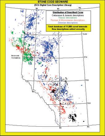
•Now offering a proprietary core index on-line via STONECODE HUB.
•Over 11,000 Carbonate and Clastic core interval descriptions in the WCSB available.
•If you cannot visit the core, the SCG interpretation can visit you, on your desktop.
•For a full listing of available core descriptions g o to www.scgltd.com and follow the links.

Stoakes Consulting Group Ltd
Suite 402, 103 - 10th Avenue NW, Calgary, AB, Canada T2M 0B4
In intervals where there is no bad hole or light hydrocarbon, the reconstructed logs should match the original log curves. If they do not, some parameters in the petrophysical analysis or the reconstruction model are wrong and need to be fixed. It may take a couple of iterations. Remaining differences are then attributed to the repair of bad hole effects and light hydrocarbons in the invaded zone. The reconstruction needs to encompass somewhat more than the immediate zone of interest, but not usually the entire borehole.
There are a dozen or more published methods for generating synthetic logs, some dating back more than 60 years, long before the computer era. Most are too simple to do a good job; others are too complicated to be practical.
The most successful and practical model to implement and manipulate is the Log Response Equation. This equation represents the response of any single log curve to shale volume, porosity, water saturation, hydrocarbon type, and lithology.
Another valid modern method is multiple linear regression to generate missing or to replace bad data. This requires very careful
(Continued on page 22...)
ph: (403) 262-6003 fax: (403) 265-4662 email: stonecode.scg@shaw.ca
RESERVOIR ISSUE 5 • MAY 2013 21
RECOMMENDED PARAMETERS Density DTC DTS kg/m3 usec/m usec/m Shale 2200 - 2600280 - 500490 - 770 resh water 1000 656 1280** alty water 1100 616 1200** il (light - heavy) 700 - 1000770 - 616 1200** Gas Not required for a log reconstruction for stimulation design Granite 2650 182 262 Quartz 2650 182 291 Limey sandstone 2680 170 292 Limestone 2710 155 294 Limey dolomite 2800 150 270 Dolomite 2870 144 245 Anhydrite 2900 164 280 Coal 1200-1800 328+ 500+
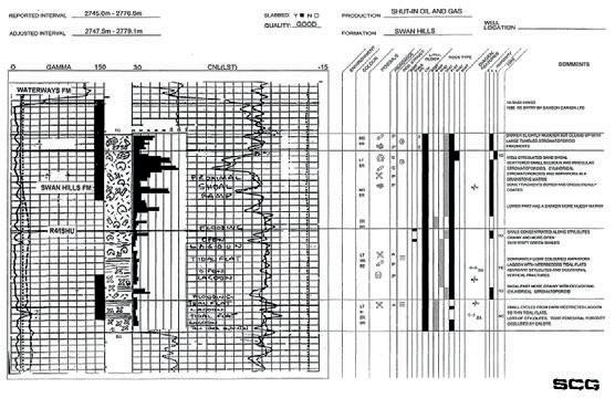
TABLE 1:
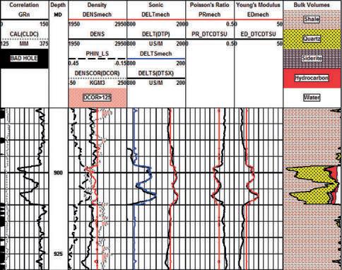
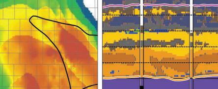
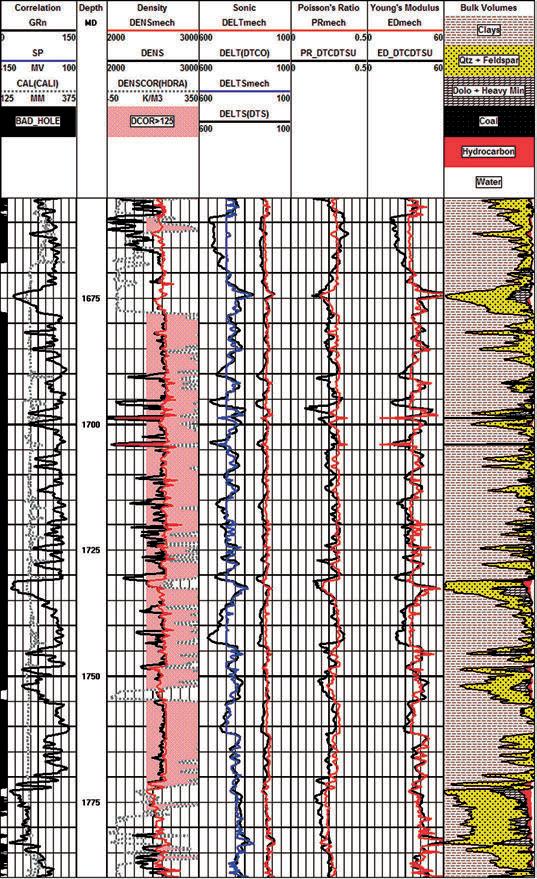
Figure 1: Example of synthetic density and sonic logs used to calculate elastic properties for a fracture design study. Track 1(Correlation) has GR, caliper, and bad hole flag (black bar). Track 2 (Density) has density correction (dotted curve), neutron (dashed), original density (black), synthetic density (red). Track 3 (Sonic) shows the synthetic shear sonic (blue), synthetic compressional sonic (red), along with the original sonics (black). Track 4 (Poisson’s Ratio) displays calculated results using raw data (black) and using modeled data (red). Track 5 (Young’s Modulus) displays similarly shows results from the original log (black) and the modeled log (red). Track 6 (Bulk Volumes) displays the rock composition used as input to the modeling process. Note the error in the original shear sonic data above and below the sand interval (reading much too high). The modeling process was used to remedy this.
(...Continued from page 21)
consideration of a discriminator curve to select valid input data. The drawback is that the output curves cannot be manipulated with individual parameters in different lithologies or fluid types, as can be done with the Log Response Equation.
CREATING SY NTHETIC LOGS FROM THE LOG RESPONSE EQUATION
The best and easiest modern method for log reconstruction uses the Log Response Equation. Results are based on a complete and competent petrophysical analysis run using only good log data over the interval of interest, and a little above and below that interval. This article does not cover the petrophysical analysis methods needed - they are well documented elsewhere at ww.spec2000.net/01-index.htm.
The equations needed are:
1: DENSsyn = Vsh * DENSSH + DENS1 * Vmin1 + DENS2 * Vmin2 + DENS3 * Vmin3 + PHIe * Sw * DENSW + PHIe * (1 - Sw) * DENSHY
2: DTCsyn = Vsh * DTCSH + DTC1 * Vmin1 + DTC2 * Vmin2 + DTC3 * Vmin3 + PHIe * Sw * DTCW + PHIe * (1 - Sw) * DTCHY
3: DTSsyn = Vsh * DTSSH + DTS1 * Vmin1 + DTS2 * Vmin2 + DTS3 * Vmin3 + PHIe * Sw * DTSW + PHIe * (1 - Sw) * DTSHY
Where: DENSsyn, DTCsyn, and DTSsyn are synthetic density, compressional and shear sonic DENSx, DTCx, and DTSx are density and sonic parameters for each mineral and fluid. Other symbols and abbreviations are listed in the Nomenclature at the end of this article.
Equation 1 is physically rigorous. Equation 2 is the Wyllie time-average equation, which has proven exceedingly robust despite its lack of rigor. Equation 3 is discussed below.
Sharp eyed readers will notice that there is a porosity term in Equation 3. Everyone knows that a fluid in a pore does not support a shear wave, but porosity does affect shear wave travel time in a manner similar to the compressional travel time. Consider the following equations:
4: Kc = Kp + Kb + 4/3 * N
5: DTC = 1000 / ((Kc / (0.001 * DENS)) ^ 0.5
6: DTS = 1000 / ( (N / (0.001 * DENS)) ^ 0.5)
Bulk moduli are in GPa, density is in kg/m3, and sonic travel times are in usec/m in these equations.
It is clear from Equations 5 and 6 that both DTC and DTS depend on density, which in turn depends on mineral composition, porosity, and the type of fluid in the porosity. Both Kc and N depend on mineral composition and the presence of porosity.
So extending the Wyllie time-average equation to the case of shear travel time is not so far-fetched, and the use of a pseudotravel time for the fluid term is merely a convenient way to avoid the pain and sorrow of the Wood-Biot-Gassmann equation set.
Parameters used in the response equations are chosen appropriately for the case to be modeled. The Sw term varies with what you are trying to model. If you want to model the undisturbed state of the reservoir, Sw is the water saturation from a deep resistivity log and an appropriate water saturation equation. If you want to see what a log would actually read in that zone, you need the invaded zone water saturation, because that’s what most logs see. Invaded zone saturation, Sxo, can be derived using a shallow resistivity curve, or it can be assumed to be Sw^(1/5).
If you want to see what a water zone would look like, Sw is set to 1.00. That is what we do for a reconstruction destined to be used in calculating rock mechanical properties for stimulation design.
In all cases, you need to select fluid parameters to match the assumptions of the model. For example, to reconstruct a log run through an invaded gas zone to reflect the undisturbed case, you need to use the undisturbed zone water saturation and appropriate fluid properties for the water and gas in each equation. Note that for stimulation design, a gas model is not required. For seismic modeling, it is required.
Matrix and fluid values for each required log curve are given in Table 1 (page 21). They may need some tuning to obtain a good match to measured values. Shale values are chosen by observation of the log readings in shale intervals. You may have to look to offset wells to find a shale that does not suffer from bad hole effects.
The shear travel time values in Table 1 (page 21) for fluids represent pseudo-traveltimes that act as proxies in the Response Equations to account for the effect on density when gas, oil, or water are present.
22 RESERVOIR ISSUE 5 • MAY 2013
This is a pragmatic solution that works well. If you want more rigor, you need to use the Wood-Biot-Gassmann equation set.
For those who are unhappy with Equation 3, the usual shortcut that can be used is to determine a DTC multiplier (DTS/DTP) based on the lithology as determined from the petrophysical analysis:
7: DTSsyn = KS8 * DTCsyn
TABLE 2: KS8 – DTS / DTC MULTIPLIER
It is reasonable to calculate a composite KS8 multiplier value using the volume weighted fraction of each rock component. The multiplier is relatively independent of porosity. Because the range of KS8 for typical rocks is moderately large, Equation 3 is actually easier to manipulate since each mineral and shale volume parameter can be tuned separately.
An example of a reconstruction using the response equation model for a stimulation design in a Viking reservoir is shown in Figure 1. A detailed petrophysical analysis, not shown here except for the lithology track, preceded the reconstruction, and provided the shale volume, porosity, water saturation, and mineralogy inputs required.
ERROR PROPAGATION
The main reason for calculating synthetic log curves is to reduce the errors in calculated mechanical rock properties. Of all the properties that can be calculated from logs, Poisson’s Ratio suffers the worst error if there are even small errors in the log data used to derive it. Unfortunately, Poisson’s Ratio is also the most import input required in calculating the closure stress, a key parameter in hydraulic fracture design.
To illustrate where Poisson’s Ratio fits into a frac design, consider the simple case of isotropic reservoirs as defined by:
8: R = DTS / DTC
9: PR = (0.5 * R^2 - 1) / (R^2 - 1)
10: Pclos = (PR / (1 – PR)) * Po + (1 – (PR / (1 – PR))) * Pp * ALPHA
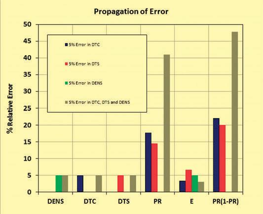
Both equations 9 and 10 amplify any errors in the initial DTC and DTS data by surprisingly large amounts. Figure 2 and Table 3 presents the propagation of error for four cases, representing a +/-5% error in individual inputs and a combined case in which all three inputs are in error and non-compensating.
Another example of synthetic logs with the original measured curves, and the computed rock mechanical properties, is shown in Figure 3 (page 24). Black curves show the original logs and calculated results from those original logs. Coloured curves show the synthetic logs and results from the synthetic logs.
(Continued on page 24...)
RESERVOIR ISSUE 5 • MAY 2013 23
Coal 1.9
Shale 1.7
Limestone 1.8
Dolomite 1.7 to 1.8 Sandstone 1.6 to 1.7
to 2.3
to 2.1
to 1.9
Figure 3: Example of log reconstruction in a Dunvegan shaly sand sequence. Curve complement and colour codes are the same as Figure 1. Although the density correction is large (orange shading in Track 2), the reconstructed log shows a close resemblance to the recorded density. The shear and compressional sonic show larger differences caused by the rough hole and some light hydrocarbon effect.
Figure 2: Effect of error propagation of a +/-5% error in DTC, DTS, DENS, and all three combined on calculated rock properties.
The bargraph and table show how a single 5% error is multiplied four-fold by the nature of the Poisson’s Ratio equation.
(...Continued from page 23) TABLE 3:
CONCLUSIONS
We have shown how small input errors amplify to become surprisingly large due to the inherent nature of the equations that are used to obtain rock mechanical properties.
To reduce error propagation issues, reconstructed or synthetic logs are an essential input to stimulation design software packages. Creating such logs requires a significant effort to first produce a competent petrophysical analysis. However, that analysis has other uses, such as determining completion intervals and the best location for horizontal wells, not to mention the more usual applications such as reserves and productivity estimates. So the effort is not wasted.
In the end, the cost of the full analysis and reconstruction is trivial compared to the cost of completion, or worse, an unsuccessful completion design.
NOMENCLATUIRE
DENS = density of rock including fluid filled porosity (kg/m3)
Kp = compressional bulk modulus of the pore space (GPa)
Kb = compressional bulk modulus of empty rock frame (GPa)
Kc = composite bulk modulus of rock including fluid filled porosity (GPa)
N = shear modulus of rock including fluid filled porosity (GPa)
DTC = compressional sonic travel time (usec/m)
DTS = shear sonic travel time (usec/m)
PR = Poisson’s Ratio (unitless)
Po = overburden pressure (KPa)
Pp = pore pressure (KPa)
Pclos = closure stress (KPa)
ALPHA = Biot’s Constant (unitless)
E. R. (Ross) Crain, P.Eng. is a Consulting Petrophysicist and Professional Engineer, with over 50 years of experience in reservoir description, petrophysical analysis, and management. He is a specialist in the integration of well log analysis and petrophysics with geophysical, geological, engineering, stimulation, and simulation phases of the oil and gas industry, with widespread Canadian and Overseas experience. He has authored more than 60 articles and technical papers. His online shareware textbook, Crain’s Petrophysical Handbook, is widely used as a reference for practical petrophysical analysis methods. Mr. Crain is an Honourary Member and Past President of the Canadian Well Logging Society (CWLS), a Member of SPWLA, and a Registered Professional Engineer with APEGA.
Dorian Holgate is the principal consultant of Aptian Technical Limited, an independent petrophysical consulting practice. He graduated from the University of Calgary with a B.Sc. in Geology in 2000 and completed the Applied Geostatistics Citation program from the University of Alberta in 2007. After graduation, he began working in the field for BJ Services (now Baker Hughes) and completed
BJ’s Associate Engineer Program. Later, he joined BJ’s Reservoir Services Group, applying the analysis of well logs to rock mechanics to optimize hydraulic fracturing programs. In 2005, Dorian joined Husky Energy as a Petrophysicist and progressed to an Area Geologist role. He completed a number of petrophysical studies and built 3-D geological models for carbonate and clastic reservoirs. Dorian holds membership in APEGA, CSPG, SPE, SPWLA, and CWLS.
24 RESERVOIR ISSUE 5 • MAY 2013
AB OUT T HE AUTHORS
Input Data Error Error In Calculated Results Case DENS DTC DTS PR E PR/(1-PR) One 0 5 0 18 3.5 22 Two 0 0 5 15 7.0 20 Three 5 0 0 – 5.0 –Four 5 5 5 41 3.0 48
ERROR PROPAGATION
Ross Crain
Dorian Holgate
ROCK SHOP

Reservoir Geomodeling Reservoir Simulation Integrated Study
Julee Lee (403) 554-3957, Helen Cao (403) 968-6268, Gary Selby (403) 818-1594
jlee@petrosteer com, hcao@petrosteer com, gselby@petrosteer com


PRACTICAL LOG ANALYSIS
In-House and Multi-Media Narrated Self-Study Courses Also Available
Instructor: E. R. (Ross) Crain. P.Eng. 1-403-845-2527 ross@spec2000.net
50 Years Worldwide Experience – Analysis, Training, Mentoring, Forensic Reviews –


RESERVOIR ISSUE 5 • MAY 2013 25 Strip Log Strip Log Horizontal Log Horizontal Log Mud Log Mud Log Log Viewer Log Viewer Log Manager Log Manager Log Analysis Log Analysis Suite 102, 7370 Sierra Morena Blvd SW, Calgary, AB T3H 4H9 info@WellSight.com 1-800-447-1534 (403) 237-9189
Excellence in Geological Services for Over 20 Years Integrated Reservoir Studies for All Resource Types 4D Geomodelling & Geosteering Horizontal Well Path Planning Infill Well Placement Studies SMART4D Modelling ® Software www.uo gc.co m 4 03.265. 0111 91 0 , 396 11th Ave SW C a lgar y, AB Cana da WELLSITE GEOLOGICAL SUPERVISION Cell403 819 2516 farhat@sableconsultants.com SABLECONSULTANTS.COM Conventional Wells Coring Programs Heavy Oil/Oil Sands Coal Bed Methane SAGD Horizontal Project Supervision www.rpsgroup.com/energy (403)263-0449 17084 Global Leaders in Wellsite Geology Serving the petroleum industry for over 25 years ■■ Conventional Vertical / Horizontal Wells ■■ Unconventional Heavy Oil / CBM Wells ■■ International WSG / Operations Geology • Domestic and International wellsite supervision • Conventional and Unconventional wells • Extensive Hz experience • Customized corporate solutions available (403) 250-3982 sales@clconsultants.ca www.clconsultants.ca
COURSES For Engineers, Geologists, Geophysicists, and Technicians Practical Quantitative Log Analysis: 15 – 17 Apr 2013 Analysis of Unconventional Reservoirs: 18 Apr 2013 Analysis of Rock Mechanical Properties: 19 Apr 2013 Details and Registration at: www.spec2000.net/00-coursedates.htm
===
=== –
油田投资项目咨询 油田收购评估 油气田勘探开发技术支持
www.petrosteer.com 贝 特 斯 亚 海 外 石 油 研 究 中 心

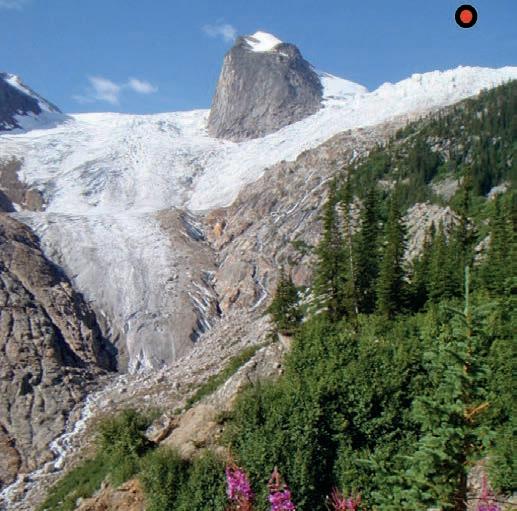
GO TAKE A HIKE
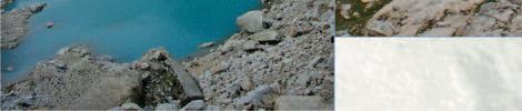
The Bugaboos, Bugaboo Provincial Park, B.C.
| By Markus Ebner
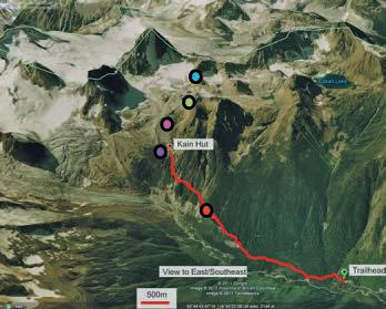
Trailhead: From junction with TransCanada Hwy drive south on Hwy 93, approximately 260 km to Radium Hot Springs, B.C. From here, travel 28 km north on Highway 95 to Brisco, B.C. It is strongly advised to have a 4x4 or AWD vehicle as you will be on rough forestry roads. Go west at the village of Brisco on Brisco Road and follow the signs that lead one to Bugaboo Provincial Park (45km). Once in the parking lot it is imperative that you wrap your car in chicken wire (especially when left overnight – piles of wire provided at the west end of the lot) to prevent large rodents from gnawing rubber hosing. The trailhead is clearly marked by a billboard map at the east end of the large parking lot.
Dista nce and Caution: 9km return. The hike as described here is an ‘In and out’ to the Alpine Club of Canada’s Kain Hut. There are many more trails that splay above and beyond the hut that lead one into high alpine terrain. Proper mountaineering equipment and training is essential to travel beyond the hut. The hike as described here is an advanced hiking trail that requires some exposed traverses on narrow ledges, a ladder climb and a steep, chain-hand railed staircase climb to reach the hut. Weather in the Bugaboos is often more extreme and variable than one would experience elsewhere in the Rockies. Be prepared even on warm summer days for torrential downpours, lightning and cool winds. The typical hiking season here ranges from early Summer to early Fall.
Elevation Gain: 700m to the Kain Hut. Plan on 3 - 8 hours return.
The Bugaboos are a geological odyssey that match the splendor of the Patagonian granitic spires, but are conveniently found in our own backyard. They offer spectacular views and a world class alpine rock climbing arena, and while relatively isolated, are accessible to the prepared hiker. As the hike starts, one will pass through a lush forest and a creek crossing laden with glacial sediment. Shortly, the ascent begins and one will weave through a naturally formed staircase-trail over lateral and terminal moraines – remnants from the most recent Holocene glaciation. After ascending the main lateral moraine you will soon emerge from the forest into an alpine meadow. It is from this stunning flower filled meadow where you will get your first view of the incredible granitic spires. Above the meadow, one will come shortly to a series of steeper headwalls that you must traverse across and upwards. The well worn trail leads the hiker though a number of thin ledges, a ladder climb and a cement cast-staircase in granite with concrete (all of which have support from a chain linked hand railing). Once atop the staircase, a series of steeper switchbacks on sturdy granite boulders leads one to the Kain Hut. This is a magnificent hut perched at the tree line, with amazing views and a perfect spot for lunch.
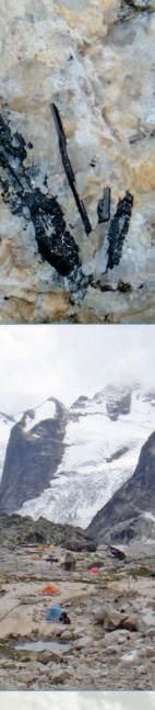
In the early Cretaceous (approximately 135 million years ago) the Bugaboo Batholith was emplaced perhaps 8 km below the surface within the Hadrynian (late PreCambrian) Horsethief Creek Group (consisting of submarine fan and deep marine clastic deposits). This intrusion was followed by a further series (the Horsethief Creek Batholith) dating between 122 and 94Ma (Hoy and Van der Heyden, 1988). The Bugaboo Batholith has a western unit of fine grained hornblende-biotite granodiorite and to the east a quartz monzonite. The younger Horsethief Creek Batholith is zoned from fine crystalline to porphyritic biotite quartz monzonite with large buff to pink coloured orthoclase feldspar (often called K-spar) phenocrysts. The slow cooling over millions of years allowed the development of the coarse-grained igneous rock. Subsequent uplift of the batholith and erosion of the surrounding country rock exposed the intrusion. Further periods of glaciation, that are still evident and active today, finished carving the spires into the form we see them as today.
Prior to the formation of the Rockies a similar range was developed west of the present day Rocky Mountain Trench. The aforementioned batholiths cut the Purcell Thrust (part of that range) and thus fault activity in that range must have ended prior to the emplacement of batholiths. In some of the boulders near and above the Kain hut, one can see larger, irregularly shaped inclusions of country rock (The Horsethief Creek Group) in the granite.
REFERENCES:
Atkinson, C and Piche, M., 2003. The Bugaboos. Elaho Publishing. Hoy T. and Van der Heyden P., 1988. CJES, V.25, 106-115
Pope.A., 1990. “Toby-Horsethief Creek Map Area. MEMPR Open File 1990-26.
Reesor, J. E., 1973 Geology of the Lardeau Map Area, East-Half, British Columbia Memoir, Geological Survey of Canada, Memoir 369.
Pers. Comm.: Clint Tippett; Oct 1, 2011.
Background
by Astrid Arts.
Photo
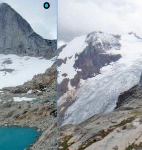
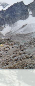
View of Snowpatch Spire and the Crescent Glacier.
26 RESERVOIR ISSUE 5 • MAY 2013
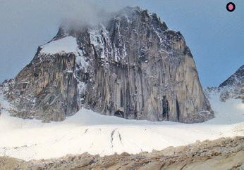
View of the Hound’s Tooth from the alpine meadow as one nears the Kain Hut. The heavily crevassed Bugaboo Glacier mantles its steep flanks.
The Reservoir Committee welcomes contributions from our readership to this series.
If you wish to offer a submission to Go Take a Hike on your favourite hike of geological interest, email the Reservoir at caitlin.young@cspg.org for more information.


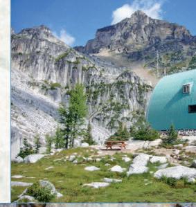


 Above: Applebee Dome Camping area with the view toward the Hound’s Tooth and Bugaboo Glacier. Exploration of outwash placer in creeks draining from the glacier lead some companies in the past to stake claims in the region on the basis of elevated amounts of uranium, niobium, thorium, molybdenum, and tungsten (Pope, 1990).
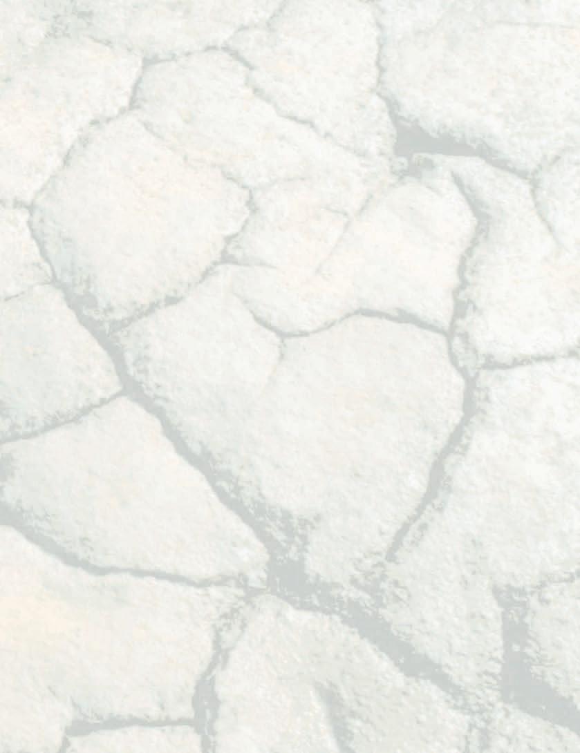
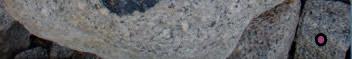
The rubble below the steep cliffs approaching the hut contains hornfels: country rock (Horsethief Ck group in this case) that has been recrystallized by contact metamorphism. The rock is ~30cm long.
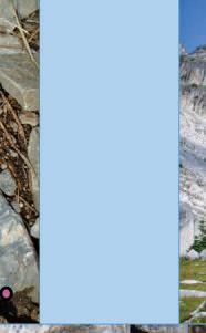
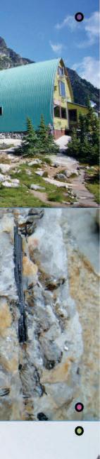
The Alpine Club of Canada’s Kain Hut, named after Conrad Kain a guide who summited Mount Robson in 1913 and Bugaboo Spire in 1916.
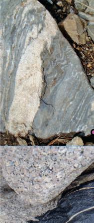
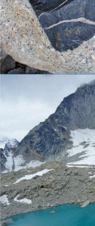
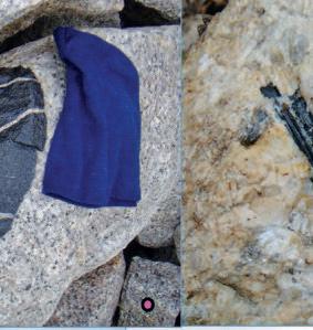
A close up of the coarse grained granite of the bugaboos with a xenolith (a portion of the 600-1000Ma country rock that has detached and settled into the magma chamber). Note its fractures and rounded, partially melted shape. Blue beanie for scale.
Porphyritic quartz monzonite with black 5-6 cm long hornblende crystals enclosed by large pink k-spar and quartz (white) crystals.
Above: Applebee Dome Camping area with the view toward the Hound’s Tooth and Bugaboo Glacier. Exploration of outwash placer in creeks draining from the glacier lead some companies in the past to stake claims in the region on the basis of elevated amounts of uranium, niobium, thorium, molybdenum, and tungsten (Pope, 1990).
The rubble below the steep cliffs approaching the hut contains hornfels: country rock (Horsethief Ck group in this case) that has been recrystallized by contact metamorphism. The rock is ~30cm long.
The Alpine Club of Canada’s Kain Hut, named after Conrad Kain a guide who summited Mount Robson in 1913 and Bugaboo Spire in 1916.
A close up of the coarse grained granite of the bugaboos with a xenolith (a portion of the 600-1000Ma country rock that has detached and settled into the magma chamber). Note its fractures and rounded, partially melted shape. Blue beanie for scale.
Porphyritic quartz monzonite with black 5-6 cm long hornblende crystals enclosed by large pink k-spar and quartz (white) crystals.
RESERVOIR ISSUE 5 • MAY 2013 27
View of Bugaboo Spire and the Upper Crescent Glacier taken from Eastpost Spire.
CSPG PROFESSIONAL DEVELOPMENT
2013 EDUCATION PROGRAM
SOFT SKILLS
GENERAL GEOSCIENCES


LocationTitle Authors Nb Days Dates Member Cost (CAD)* Downtown Calgary Communicating geoscience: writing and talking about the earth's subsurface Matt Hall 1d May 3 350 Downtown Calgary Time Management – Strategies, Tips & Techniques to Get Control of Your Day, Life and Career Bruce Lee 1d May 13 350 Downtown Calgary Networking: Real World & Real Time Connections - Creating Powerful New Circles of Influence Bruce Lee 1d Oct 24 350 LocationTitle Authors Nb Days Dates Member Cost (CAD)* Downtown Calgary Introduction to Directional Drilling and Geological Placement Glen Eckert 1d May 2 825 Downtown Calgary Advanced topics in Directional Drilling and Geological Placement Glen Eckert 1d May 3 825 Downtown Calgary Introduction to the RDA Software - bed dips, fracture analysis and geosteering Andrew Newson 3d May 13-15 1,475 Field Seminar Drilling and Production; a Trip to a Working Drilling Rig and Production Facilities David Hill 1d June 7 550 Downtown Calgary Drilling & Production Fundamentals David Hill 2d Oct 21-22 950 LocationTitle Authors Nb Days Dates Member Cost (CAD)* Downtown Calgary Geological and Seismic Interpretation in Structurally Complex Settings Marian Warren Mark Cooper 3d May 1-3 1,650 Downtown Calgary Introduction to Petroleum Geostatistics Clayton Deutsch 2d May 2-3 1,175 Downtown Calgary Deepwater Petroleum Systems with an Emphasis on Reservoir Characterization and Linked Depositional Systems Grant Wach 1d May 9 550 Downtown Calgary Understanding Financial Statements Peter Flynn 1d May 13 550 Downtown Calgary Sequence Stratigraphy: Principles and Applications Octavian Catuneanu 2d May 13-14 1,170 Downtown Calgary Survival Petrophysics Course Winston Karel 3d May 15-17 1,600 Field Seminar Geology for non Geologists Jon Noad 1d June 20 350 Downtown Calgary Conflict Resolution within the Realm of Oil & Gas Negotiations David Hill 2d Oct 23- 24 950 Downtown Calgary Fluvial Stratigraphy John Holbrook 2d Oct 23-24 1,050 LocationTitle Authors Nb Days Dates Member Cost (CAD)* ERCB Core Introduction to Carbonate Core workshop – overview of the Devonian in the Western Canadian Sedimentary Basin Eva Drivet, David Hills & Laurie Slezak 0.5dMay 1 (am) 435 Field Seminar Stratigraphy and Hydrocarbon Systems of the Sappington (Bakken/Exshaw) and Three Forks Formations in Western Montana** Ted Doughty George Grader 3d Jul 25-27 1,500
PRODUCTION
CARBONATES
* + CAD125 for Non-member ** Course listed both under Clastic and Carbonates Latest update: www.cspg.org page 1 of 2
2013 EDUCATION PROGRAM CSPG PROFESSIONAL DEVELOPMENT
2013 EDUCATION PROGRAM
2013 EDUCATION PROGRAM
CLASTIC
and Sedimentological Analysis at Willapa Bay, a Mesotidal
and Meandering
Stratigraphy and Hydrocarbon Systems of the Sappington (Bakken/Exshaw) and Three Forks
Field Seminar Subtidal Sandbodies Heterogeneity and Sequence Stratigraphic Distribution in the Gog Group of the Southern Canadian Rockies: Insights for Reservoir Modelling
SHALE GAS
OIL SANDS


2 of 2
CSPG PROFESSIONAL
Latest update: www.cspg.org CSPG PROFESSIONAL DEVELOPMENT * + CAD125 for Non-member ** Course listed both under Clastic and Carbonates LocationTitle Authors Nb Days Dates Member Cost (CAD)* ERCB Core Clastics Facies and Depositional Environments in Core Bill Arnott 3d May 1-3 1,525 Downtown Calgary The Architecture of Fluvial Reservoirs Andrew Miall 2d May 2-3 855 ERCB Core Subsurface Methods In Clastic Sediments Doug Cant 2d May 2-3 1,000 ERCB Core Mannville Stratigraphy, Sedimentology and Petroleum Geology Doug Cant 3d May 15-17 1,775 Field Seminar
Estuary Murray Gingras4.5dMay 25 pm-29 1,900
DEVELOPMENT
Ichnological
Contrasting the
systems Jon Noad1.5dJune 12 pm-13 540 Field Seminar Tide-Dominated Depositional Environments in the Bay of Fundy, Canada Murray Gingras Shahin Dashtgard 4d June 12-15 2,650 Field
Formations
Western Montana** Ted Doughty George Grader 3d Jul 25-27 1,500
Patricio Desjardins Luis Buatois 3d Sep 4-6 1,775 ERCB Core Mannville Stratigraphy, Sedimentology and Petroleum Geology Doug Cant 3d Oct 16-18 1,775 ERCB Core Subsurface Methods In Clastic Sediments Doug Cant 2d Oct 21-22 1,000 ERCB Core Rock Creek Stratigraphy, Sedimentology and Petroleum Geology Doug Cant 1d Oct 25 625 LocationTitle Authors Nb Days Dates Member Cost (CAD)* Downtown Calgary Practical Geomechanics for Unconventional Oil and Gas Pat McLellan 2d May 15-16 1,500 LocationTitle Authors Nb Days Dates Member Cost (CAD)* Downtown Calgary Viscous Oil Production Methods and GeoScience Screening Criteria Maurice Dusseault 2d May 2-3 1,275 Downtown Calgary How to Build
Ground LiDAR
Case Histories C. Aiken, M. Wang & L. White 1d May 3 500 Field Seminar SAGD Fundamentals - Field Seminar in Fort McMurray, Alberta R. Strobl, M.Fustic & D.Wightman 2d June 18-19 1,950 Field Seminar Geology of the Athabasca Oil Sands Murray Gingras & Mike Ranger 3d Sep 5-7 3,650 Field Seminar Glacial sedimentology for oil sands geologists Nick Eyles 3d Sep 11-13 1,490 Field Seminar
field trip: modern environments and reservoir characterization Hugues Fenies 4d Sep 17-20 3,400
Field Seminar
Reservoirs of Braided
depositional
Seminar
in
and Use 3D Virtual Models of Outcrops at High Resolution and Accuracy Using
and Digital Photography, with
Gironde estuary and Aquitaine coast
page
CSPG Award Ceremony
Please join us at the CSPG Awards & Volunteer Recognition Presentations
May 6, 2013 5:30pm – 7:30pm
Imperial Ballroom, Hyatt Regency
This is your night as a CSPG contributor to be recognized in front of your peers, friends, and family. Reception follows.
30 RESERVOIR ISSUE 5 • MAY 2013
HONORARY MEM BER OF TH E CSPG W.R. (Bill) May
Bill May has had a very successful career; driven by his love of geology, a lifelong passion for learning and a strong desire to give back to his profession and to his community.
Bill was born in Montreal and since high school he knew that he wanted to be a geologist. He graduated from Dalhousie University with a B.Sc. Honours in Geology and a minor in Engineering. He started his career in the mining industry and in 1974 joined Amoco Canada to start a career in the petroleum industry. Early projects included the structurally complex Ricinus field where Bill’s work added 6 mmbo. Later success included recommending a Beaver Hill Lake prospect at Blackstone with geophysicist Rick Flury, which has produced 0.8 Tcf to date. In conjunction with this work, Bill led a field party that mapped the facies and reservoir quality of these units in the Rockies
In 1978 Bill moved to Anschutz Canada, where he was responsible for prospect generation and drilling, testing and completion operations for between 60-130 wells/year. He enjoyed continued success as a proven oil and gas finder. Bill attributes his success to a combination of creativity and a rigorous, disciplined approach to prospect generation.
Bill’s early exploration career was terminated by low product prices in 1986. Bill had just been elected Treasurer of the CSPG and he turned himself into a volunteer accountant. At that time, the accounting for the Society was done by their auditor who once a year was given boxes of bills and receipts to organize. He setup an accounting system for the Society, a financial reporting system for committees and he computerized the Society’s office. Bill served on the CSPG executive from 1986-1990 as Treasurer, Vice President, President and Past President. During Bill’s tenure the number of CSPG committees increased to 92 with over 600 volunteers with the addition of employment, education and specialist conference committees.
In 1989 Bill started W.R. May & Associates Petroleum Consultants focusing on regional geological studies for the next 10 years. Bill later served as an officer or director of public and private companies and as
general partner of limited partnerships. He was a co-founder of three small companies including one junior capital pool company and Excite Energy, which he sold in 2006 in order to retire. He is currently President of a registered charitable organization.
Bill has made technical presentations to the CSPG and to the Canadian Well Logging Society. In addition, he has taught geological courses to petroleum geoscientists and engineers and field schools. He has provided leadership on over 40 industry and community committees including over 20 CSPG committees, the Banff Conference Committee (University of Alberta), the Advisory Committee (Alberta Geological Survey), Faculty of Science Council (University of Calgary) and
Vice-Chair, 1992 AAPG convention. He has received 14 volunteer service awards including Volunteer, Service, Tracks and President’s awards from the CSPG. In 2009, Bill was made a Fellow of Engineers Canada in recognition of his volunteer work for that profession.
In recognition of Bill’s many exploration successes and his outstanding contributions to the CSPG we welcome him as an Honorary Member of the CSPG.
RESERVOIR ISSUE 5 • MAY 2013 31
Reach more than 3000 petroleum professionals who are empowered to purchase your product or service. ADVERTISE IN TH E RESERVOIR Please call: Emma MacPherson Tel:403.513.1230 Email:emma.macpherson@cspg.org
HONORARY MEM BER OF TH E CSPG
Andrew D. Miall

Andrew Miall was born in Brighton, England, and obtained his B.Sc. at the University of London. He then emigrated to Canada and obtained his Ph.D. in Arctic geology at the University of Ottawa in 1969. Andrew continued moving westward and came to Calgary to work with J.C. Sproule and Associates and Shell before joining the Geological Survey of Canada in 1972.
Andrew’s role at the Survey was to carry out regional basin studies and mapping in the Arctic Islands, and he also developed his academic interests as well. By 1977,
an international symposium on fluvial sedimentology in Calgary. This symposium led to the publication of CSPG Memoir 5. In 1979, Andrew moved back east to become a professor at the University of Toronto where he continues to teach and carry out research.
In addition to his specialized work on fluvial sedimentology, Andrew is probably equally well known for his work on sequence stratigraphy and insightful critiques of the Exxon global cycle charts. His technical books include Principles of Sedimentary Basin Analysis and Geology of Stratigraphic Sequences, and Andrew is currently completing another book on fluvial sedimentology. With Nick Eyles, Andrew co-authored Canada Rocks, a history of the geology of Canada for nonscientists which was named Science book of the year by the Toronto Star in 2007. Andrew has also presented short courses on these topics for the CSPG fifteen times since 2004, in addition to many courses for other professional geoscience organisations worldwide.
With his wife, Charlene, a professor of Sociology at McMaster University, Andrew conducted 71 interviews across Canada, and used data from a web-based survey to publish papers on Canadian earth scientists’ perspectives on geology
Andrew served as editor of Geoscience Canada for 8 years, as co-editor of the journal Sedimentary Geology for 18 years, and is currently the Sedimentology editor for the journal Earth Science Reviews.
Andrew has been much honoured for his work. He was awarded the Past President’s Medal of the GAC in 1983, and was elected a Distinguished Fellow of that society in 1995, the same year he was inducted into the Royal Society of Canada. In 2001 he was awarded an Honorary Doctorate by the University of Pretoria, South Africa, and in 2004 he received the Grover E. Murray Distinguished Educator Award from the American Association of Petroleum Geologists.
Andrew served as President of the Academy of Science of the Royal Society of Canada from 2007 to 2009. Recently he has served on the federal Oil Sands Science Advisory Panel and Alberta Environmental Monitoring Panel. These studies have helped to bring about major improvements in the monitoring practices being carried out in the Lower Athabasca area.
As a field geologist, a research scientist, and a nationally and internationally recognized scholar in the field of petroleum geology Andrew is an outstanding candidate for


Elbow Springs Golf Club • June 20-21, 2013
The Tournament would like to thank the following 2012 sponsors:
Diamond Sponsors
geoLOGIC Systems
Schlumberger of Canada
Emerald Sponsors
AGAT Laboratories
Baker Hughes
Divestco
Energy Navigator Inc.
GeoStrata Resources Inc.
Haliburton Group Canada
Platinum Sponsors
ATB Corporate Financial Services
Belgo Brasserie
Belloy Petroleum Consulting
GLJ Petroleum Consultants
LXL Consulting Ltd.
Gold Sponsors
Arcis Corporation
Cambria Business Services
Canadian Discovery Ltd.
ConocoPhillips Canada
Continental Laboratories Ltd.
Datalog Technology Inc.
Little Rock Document Services
IHS Energy
MJ Systems
ProGeo Consultants
RBC Dominion Securities
RECON Petrotechnologies Ltd.
Weatherford Canada Partnership
Mocash
Paradigm Geophysical Canada Ltd.
Pason Systems Corp.
West Canadian Zipcash
National Oilwell Varco
Painted Pony Petroleum Corp.
Pajak Engineering Ltd.
Rigsat Communications
Rockwell Consulting
Sample Pro Ltd.
Registration Form
NAME:
SIGNIFICANT OTHER:
COMPANY:
ADDRESS (Bus.):
POSTAL
TELEPHONE:
E-Mail*:
* e CSPG Classic respects FOIP. (Privacy Act of Alberta) No contact information is given to third parties.
SHIRT SIZE: q S q M q L q XL q XXL
All contestants are required to have a photo in the Golfer’s Photo Roster. Former contestants who have submitted a photo in the past need not do so again. Handicap / Golf Index __________________ or Average of best three 18-hole scores in past 2 years:______________
Registration Fee: Includes two rounds of golf with power cart; Paid driving range; Door prize draws; Skill prizes; BBQ (at Elbow Springs) and Awards Banquet (Calgary Petroleum Club) both for you and your guest.

Greystone Resources Ltd.
Knowledge Energy Inc.
McLeay Geological Consulting
Silver Sponsors
Gabel Energy Inc.
Sproule Associates Ltd.
Total Gas Dectection Ltd.
Typhoon Energy Ltd.
Global Energy Services Martin Quinn
Bronze Sponsors
Candian Stratigraphic Services
Fekete Associates
Hydro-Fax Resources Ltd.
San Dago Resources Ltd.
Seismic Brokerage Services Ltd
Sponsorship Welcome, Contact: James Ablett (403) 290-7670 Visit us on Facebook or Linkedin: CSPG Classic Golf
The CSPG Classic Golf Tournament has incorporated fundraising for charity as part of the event.
In 2013 the charity selected is the CSPG Educational Trust Fund
To assist the Entertainment Committee with budgeting, please indicate if you plan to attend the two major social events of the tournament:
Thursday Barbecue: Yes q No q Friday Awards Banquet: Self: Yes q No q Guest: Yes q No q
Social Events Cancellation or Additions require 72 hours notice before the event. Please contact Scott Thain (403) 262-9229; cell (403) 999-8558 or email: cspgclassicgolf@gmail.com
Make Cheques Payable To: CSPG (Classic Golf)
Send Entries To: CSPG Classic Golf Tournament 100, 333 5th Avenue S.W. Calgary, AB, T2P 3B6
* Please photocopy your entry form and cheque before mailing.
Last day for refund requests: June 5, 2013.
or
RESERVOIR ISSUE 5 • MAY 2013 33
53rd ANNUAL
53rdCLASSIC2013
CSPG CLASSIC
cspg.org
On-Line Registration Information: Use CSPG Membership Log-In, Go to Event Registration-Social Events, CSPG Classic For Non-member
Student registration contact Scott Thain (403) 262-9229
cell (403) 999-8558
or
CODE:
CELL PHONE*:
Member Non-member Cost:
Fee $309.00 $329.00 GST
Tournament
Included
CORPORATE SUPPORTERS
AGAT Laboratories
Apoterra Seismic Processing Ltd.
ARC Resources Ltd.
Arcis Seismic Solutions
Cabra Consulting Ltd.
Canadian Natural Resources Ltd.
CGG Veritas Services Inc.
Compass Directional Services
Continental Laboratories Ltd.
Cossack Land Services Ltd.
Crescent Point Energy Trust
Datalog Technology Inc.
Edge Technologies Inc.
Encana Corporation
Exova Canada Inc.
Explor
GeoTir Inc.
GLJ Petroleum Consultants Ltd.
IHS
Kulczyk Oil Ventures
LXL Consulting Ltd.
McDaniel & Associates Consulting Ltd.
MOH & Associates Oilfield Consultants
National Oilwell Varco
Nickpoint Environmental Services
Olympic Seismic Ltd.
Paradigm Geophysical Corp.
Pason Systems Corp.
Perpetual Energy Inc.
Pioneer Professional Group
Pro Geo Consultants
ProActive Health
Pulse Seismic
Regent Resources Ltd.
Rigsat Communications
RPS Energy Canada Ltd.
SAExploration
Schlumberger Canada Limited
SeisWare
Sensor Geophysical Ltd.
Sigma Explorations Inc.
Sourcex
Total Gas Detection Ltd.
Trident Exploration Corp.
Western Geco
AS OF APRIL 10, 2013
CSPG welcomes our 2013 Corporate Supporters! The benefits of being a corporate member include:
• Recognition in the monthly Reservoir and quarterly Bulletin
• One associate membership
• Reserved tables at the technical luncheons with your company logo
• One free pass to the CSPG Core Conference
…and more! Contact Kasandra Klein at kasandra.klein@cspg.org to be a corporate member today!
GEO -C AF É –A new service for CSPG Members
The Geo-Café is an attempt to provide a new method for learning and discussion within the CSPG. The primary goal will be to focus on current topics of interest to the geological community that are not typically addressed by the Divisions. Examples might include new rules and regulations; discussion around technological developments; a recent natural or man-made disaster. Possibilities are as broad as your imagination.
T HE CONCEPT
An individual or company makes an informal thirty minute presentation on a topic followed by thirty minutes for discussion. Many topics may have broader scope or benefit from greater exposure; in which case following a successful introduction through Geo-Café they may become topics for Continuing Education, the Divisions, a luncheon presentation, or a Gussow Conference.
What if I have a topic I want to present or see discussed?
Please contact Kelsey Green (Kelsey. green@cspg.org) or Dave Russum (drussum@deloitte.ca).
Where are these held?
In the boardroom of the CSPG office in Calgary (#110, 33 – 5th Avenue SW). Depending on the success of these sessions we will look at teleconferencing or other communication methods for our more distant members.
Who can attend?
This is intended for CSPG members though
ROCK SHOP
we do recognize that certain topics benefit from input by other disciplines. We want to encourage a wide range of experience level at these events so you may be just an interested observer or a world renowned expert on a particular topic
When are Geo- C afé events held?
Whenever we have an individual willing to lead a session on an appropriate topic and when the CSPG boardroom is available. They may be held at any hour of the day depending on the leader’s availability.
How much do they cost?
These sessions are free to CSPG members and you may even get a free coffee!
Do I nee d to sign up?
Space is limited at the CSPG office so you must register through normal CSPG channels. Once registered you are expected to attend or send an alternate.
How will I know what is being presented?
Advertising of events will be solely through electronic media and at relatively short notice. The CSPG is currently looking at new methods of communicating with our members through social media so watch out for this.
Comment s? Thoughts? I deas ?
We welcome them all! Feel free to contact Dave Russum (drussum@deloitte.ca) or Kelsey Green (kelsey.green@cspg.org).
34 RESERVOIR ISSUE 5 • MAY 2013
Conventional Wells • Horizontal Wells - Spearfish - Viking - Bakken - Cardium - Horn River Shale Gas
.serpaconsulting.com
Email: afran@telusplanet.net www
Professionals in Geoscience
www.apega.ca
Branching In
Technical skills matter. Staying on top of technical developments through networking and scientific presentations helps you have a productive and successful career.
Soft skills matter too. Our publics rely on us to communicate understandable geoscience information. We have to work with people to manage budgets and projects. We need a solid knowledge of industry trends. We need exposure to case studies from all over industry so we can bring fresh approaches to our projects.
Your APEGA branch, through lunch and learn seminars and networking opportunities, can help you hone your soft skills. Branch luncheons examine local big and small innovative projects, industry trends and professional issues that keep you current and inspire new ideas.
There are also opportunities to volunteer with a branch and influence the branch’s direction and programming.
Participating in your APEGA branch is another way to support and advance the geoscience profession.

For more information: Tom Sneddon, P.Geol. Director Geoscience and Outreach
P: 403-262-7714 or 888-262-3688
E: tsneddon@apega.ca
Want to bring geology back into geophysical interpretation?
Aboard
Landmark’s new DecisionSpace® Desktop software accelerates seismic interpretation with geomodel-enabled workflows.
The geophysics and geology modules in Landmark’s new unified DecisionSpace® Desktop software share the same topology engine. This gives geophysicists easy access to framework construction tools that combine well picks and horizons to produce a high resolution, accurate geomodel. The geomodel uses conformance technology to produce well-based surfaces at the same resolution as seismic data, enabling a model that truly represents your reservoir. Get better answers faster. Visit halliburton.com/DecisionSpaceDesktop

High Science Simplified® All
© 2013 Halliburton. All rights reserved.
