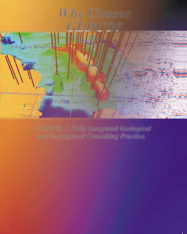
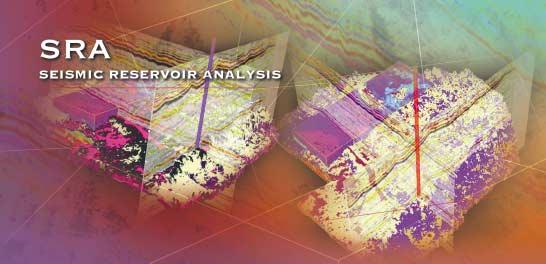
■ Dolomites: The Spectrum – Mechanisms, Models, Reservoir Development
■ Dolomites: The Spectrum – Mechanisms, Models, Reservoir Development
■ William C. Gussow Geoscience Conference – Water Resources & Energy Development
■ William C. Gussow Geoscience Conference – Water Resources & Energy Development
The Earth Imager delivers an oil-based image like you have never seen before! The Earth Imager delivers an oil-based image like you have never seen before!
The Earth Imager from Baker Atlas - delivering high resolution micro resistivity images in oil-based mud, with great hole coverage.
The proven micro resistivity imager can obtain a vertical resolution of less than 3 mm, with a standard logging speed of 274 m/hr.
It operates in boreholes from 153-533 mm, with the 6 individually articulated pads providing 64.9% borehole coverage in a 203 mm hole.
Call us today to find out how you can use the Earth Imager in your oil-based well to accurately identify structural and sedimentary features, rock texture, fracture orientation and net-to-gross.
Baker Atlas – The Best Choice
CSPG OFFICE
#160,540 - 5th Avenue SW
Calgary,Alberta,Canada T2P 0M2
Tel:403-264-5610 Fax:403-264-5898
Email:cspg@cspg.org Web:www.cspg.org
Office hours:Monday to Friday,8:30am to 4:00pm
Business Manager:Tim Howard
Email:tim.howard@cspg.org
Office Manager:Deanna Watkins
Email:deanna.watkins@cspg.org
Communications Manager:Jaimè Croft
Email:jaime.croft@cspg.org
Conventions Manager:Lori Humphrey-Clements
Email:lori@cspg.org
Corporate Relations Manager:Kim MacLean
Email:kim.maclean@cspg.org
EDITORS
Please submit RESERVOIR articles to the CSPG office.Submission deadline is the 23th day of the month,two months prior to issue date. (i.e.,January 23 for the March issue).
To publish an article,the CSPG requires digital copies of the document.Text should be in Microsoft Word format and illustrations should be in TIFF format at 300 dpi.For additional information on manuscript preparation,refer to the Guidelines for Authors published in the CSPG Bulletin or contact the editor.
COORDINATING EDITOR & OPERATIONS
Jaimè Croft
CSPG
Tel:403-264-5610 Fax:403-264-5898
Email:jaime.croft@cspg.org
TECHNICAL EDITOR
Ben McKenzie
GEOCAN Energy Inc.
Tel:403-261-3851
Email:bjmck@telusplanet.net
ADVERTISING
All inquiries regarding advertising and technical specifications should be directed to Kim MacLean.The deadline to reserve advertising space is the 23th day of the month,two months prior to issue date.All advertising artwork should be sent directly to Kim MacLean at the CSPG.
The RESERVOIR is published 11 times per year by the Canadian Society of Petroleum Geologists.This includes a combined issue for the months of July/August.
Advertisements,as well as inserts,mailed with the publication are paid advertisements.No endorsement or sponsorship by the Canadian Society of Petroleum Geologists is implied.
The CSPG Rock Shop is an attractive and affordable way for advertisers to present their services to the CSPG Readership.Spaces are sold at business card sizes (3.5” wide by 2” high) and will eventually fill an entire Rock Shop page. For more information or to book a space please contact Kim MacLean at 403-264-5610,ext.205.
The contents of this publication may not be reproduced either in part or in full without the consent of the publisher.
Design & Layout by McAra Printing
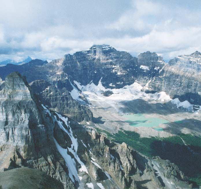
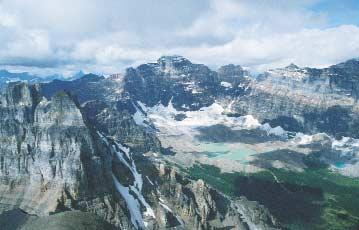
Banff National Park,Alberta – View
Mount Temple towards the glacial cirque at the head of Paradise Valley.Middle Cambrian sediments of the Cathedral,Stephen,and Eldon Formations make up the majority of the stratigraphy of Mount Hungabee (center of photo) and
peaks.Photo by Mark Dzikowski.
Edge Technologies Inc. offers extensive processing experience using proven software.
With our considerable 2D and 3D experience in the Western Canadian plains and foothills areas, we are able to provide our clients with a quality, time responsive product. Our software is highly interactive and flexible. We use leading edge algorithms including several developed for unique Canadian challenges.
CORPORATE MEMBERS
THE CSPG GRATEFULLY ACKNOWLEDGES ITS *CORPORATE MEMBERS:
ABU DHABI OIL CO., LTD. (JAPAN)
ARCHEAN ENERGY LTD.
BURLINGTON RESOURCES CANADA ENERGY LTD.
CALPINE CANADA
CANADIAN FOREST OIL LTD.
CONOCOPHILLIPS CANADA RESOURCES LIMITED
DEVON CANADA CORPORATION
DOMINION EXPLORATION CANADA LTD.
DUVERNAY OIL CORP.
ECL CANADA
EL PASO OIL & GAS CANADA, INC.
HUNT OIL COMPANY OF CANADA, INC.
HUSKY ENERGY
IHS ENERGY
IMPERIAL OIL RESOURCES LIMITED
LARIO OIL & GAS COMPANY
MJ SYSTEMS
MURPHY OIL COMPANY LTD.
NCE RESOURCES GROUP INC.
NEXEN INC.
NORTHROCK RESOURCES LTD.
PENN WEST PETROLEUM LTD.
PETRO-CANADA OIL AND GAS
REEVES WIRELINE
SAMSON CANADA
SHELL CANADA LIMITED
SPROULE ASSOCIATES LIMITED
SUNCOR ENERGY INC.
TALISMAN ENERGY INC.
TOTAL E&P CANADA LIMITED
UPTON RESOURCES INC.
MEMORIAL FOR ROBERT K. GOLDHAMMER (1957 - 2003)
When young lives are cut short,they can assume a tragic aspect in our memories.This is not how our colleague Bob Goldhammer should be remembered.
An assistant professor of geology at the University of Texas (Austin),Bob and one of his students, Raquel de Savariego,were killed in a highway accident earlier this year. He was leading a large group of students on a field school to west Texas when the accident occurred.
Bob was a unique individual who will be remembered by everyone he met.He was also an innovative and prolific researcher in the fields of carbonate geology and sequence stratigraphy.He made significant scientific contributions even before completing graduate school.His academic training began with a B.Sc.in geology (high honours) from Colgate University in 1979 and a M.Sc.from the University of Oklahoma (1982).His Ph.D.research,on the Triassic Latemar carbonate platform in the Dolomites of South Tyrol,was completed in 1987 at Johns Hopkins University.
parties in the Alberta Rockies.We can still see Bob trying to ward off the mountain cold with a ski jacket,toque,and vintage Boy Scout sleeping bag – or ordering the largest available steak with a rack of lamb on the side, no garnish,just the lamb.
In 2001 Bob accomplished one of his dreams by entering academia.He was an enthusiastic, accomplished teacher,as evidenced by the two major teaching awards he received in just two years at UT Austin.He built a major field research program in the Mesozoic carbonates of northeastern Mexico, which contributed to his most recent publications on the tectono-stratigraphy and hydrocarbon systems of the Gulf of Mexico.He also successfully organized an industry consortium at UT,studying Atlantic carbonate margins.
The latter represented a seminal contribution to the application of Milankovitch astronomical theory to sedimentary geology.Bob took the lead in developing concepts and computer models of orbital forcing,cyclostratigraphy,and its representation in the stratigraphic record –now a sub-discipline of stratigraphy.He demonstrated these concepts in numerous publications,from the Triassic of the Dolomites to the Paleozoic of the western U.S.Bob was quick to relate concepts of cyclostratigraphy to conventional sequence stratigraphy in carbonates – something that remains slow to develop.His versatility was demonstrated by further work on compaction algorithms and modeling compaction-related subsidence.
Bob enjoyed a very successful 15 years in the industry,much of it spent in the crucible of Exxon Production Research Company.He won several industry awards,including A.A.P.G. distinguished lecturer.Time at Exxon,and later Sonat and Texaco,produced more impressive work,notably a Jurassic sequence stratigraphy of the Gulf Coast and seismic stratigraphy of the salt-rafted carbonates,off-shore Angola.His colleagues at Esso Resources,Calgary,were fortunate to have him participate in two field
Bob had an incredibly quick,spontaneous sense of humor,which spared no one.He used this to great effect in his lecturing,but was forced to update his material at UT – the undergrads claimed they didn’t get a joke about Nixon because they “weren’t born then”.An accomplished musician,Bob also had an ear for language.He quickly mastered conversational Italian,Spanish,and German, and couldn’t resist deliberately brutalizing all three for comic effect.This also allowed him to do devastating imitations of friends and certain colleagues,most of who were christened with Bob’s pithy nicknames.His unique vocabulary –too voluminous to detail here – will live on with his friends.
Bob was a prodigious worker and in his twentyfive years in geology produced a lifetime’s work, in terms of both quality and quantity.For this alone will he be remembered.His family was precious to him,his wife Ursula Hammes,his daughter Nora,and son Max,aged four and one. He was a loyal friend.Anyone wishing to remember Bob by contributing to student research in carbonates,may send donations payable to the AAPG Foundation for the Robert K.Goldhammer Memorial Grant (Attn.Diane Keim,P.O.Box 979,Tulsa,OK 74101).By his own yardstick,Bob was ‘huge’ and,by comparison,the rest of us just ‘grazers’.
Here’s a test:“What organization has its roots in the CSPG,is pivotal to petroleum earth scientists,and is a recipient of a fair chunk of CSPG’s discretionary revenue – but isn’t controlled by the CSPG?” Answer:The CSPG Educational Trust Fund (ETF).
The ‘roots’ refers to the establishment of the ETF in1978 to fund the Student Industry Field Trip (SIFT).The ‘lack of control’ component is due both to a legal requirement (arm’s length) and to differing mandates.While the CSPG is a non-profit organization dedicated to serving its members,the ETF is a charitable entity (it is not a foundation,which is a specific type of charity) that reaches out to the public.The ‘pivotal’ element is the compelling part of the relationship.
Fundamentally,the ETF allocates funds to programs that shape the future of geologists in the petroleum industry.The ETF aims to raise public awareness of petroleum geology throughout Canada,and to encourage the next generation of petroleum geologists.It provides for the advancement of geological education,and seeks to enhance the profile of the earth sciences in our society.Programs such as the Student Industry Field Trip (SIFT), the CSPG Honourary Address,EdGeo (supporting elementary and high school teachers to access teaching resources for geology programs),the Visiting Lecturers Program,and various awards and scholarships for student excellence in presentations and research are all supported by the ETF.In addition,individual philanthropic requests from the general public are also given consideration by the ETF Board if the requests meet the ETF mandate.
The ETF capital is currently invested in a managed fund grouped within the Calgary Foundation (a large,professionally managed charitable foundation).At present,the ETF capital is around $750,000.Ultimately,the
A MESSAGE FROM THE FINANCE DIRECTOR
financial goal of the ETF is to reach a capital of $4 million in order to completely support ongoing programs through investment income.
Programs funded by the ETF attract the brightest and most creative minds of the current crop of young people to petroleum geology,and help to positively influence public opinion about the petroleum industry. The ETF complements the efforts of the CSPG.It is broader in scope than the CSPG, with programs reaching across Canada to people of diverse backgrounds,education levels,and ages.The ETF has the vision and mandate to look to the future of our science and our profession at a time when many petroleum companies feel they can only afford to focus people and resources on immediate,measurable financial gains.
If you care about the future of this profession,the ETF is a good place (corporately and individually) to put your money where your heart is.
Lisa A.Griffith,Finance Director
DECEMBER LUNCHEON
An integrated geological, geophysical,and oceanographic analysis of the Flat Island coarse-grained barrier complex on the west coast of Newfoundland:a new analogy for clastic reservoirs
SPEAKER
John D.Harper
ConocoPhillips Canada Ltd.
AUTHORS
Dr.Laurence Davis
and Dr.John D.Harper
Fugro Jacques GeoSurveys Inc.,St.John’s and ConocoPhillips Canada Ltd.,Calgary
11:30 am
Tuesday,December 9,2003
TELUS CONVENTION CENTRE CALGARY, ALBERTA
Please note:
The cut-off date for ticket sales is Wednesday,December 3rd. Ticket price is $28.00 + GST.
Analogies of high-energy,coarse-grained, boulder to pebble-grained coastal sands are few in the published literature yet coarse-grained sediments are a common occurrence in the geologic record.Many of these ancient deposits have economic significance in terms of the occurrence of oil and gas.Western Canadian examples include the Falher,Belly River,Viking,and Cardium reservoirs.This study of the modern Flat Island Barrier Complex in St.George's Bay,Western Newfoundland, illustrates many significant aspects for interpretation to be encountered in such coarse-grained sediments,which are directly applicable to these western Canadian reservoirs.In addition,the significance of isostatic rebound in combination with continuous sea level rise and sediment supply volume is well documented,thereby providing insight into relative sea level change and implications for sequence stratigraphy.
The Flat Island Barrier Complex consists of the main barrier of 12 km length which separates a three-kilometre-wide embayment,open to the northeast,from a one-kilometre-wide shoreface platform. The platform breaks at its 25-metre-deep
margin to a slope with relief ranging from 20 to 60 metres to the St.George's Bay seafloor.The embayment is receiving sediment from barrier washover as well as from the Flat Bay River bayhead delta. This barrier is unique in the respect that it is prograding into the 60+ metre "deep water" with attendant slump failure, submarine canyons and fans,and turbidites.The main basin attains depths of 100 metres.The coastal lowlands,about 10 kilometres wide,rise to 300+ metrehigh.fluvially dissected highlands.
Characterization of this complex as a potential reservoir will be presented in the context of defining those criteria necessary to recognize a similar environment in the ancient record. Although this complex occurs in a storm-driven high energy,mid-latitude setting sheltered from the open ocean,it should not be interpreted that this setting is the only place where one might expect such a complex to occur.With the proper combination of sea level rise, tectonic movement,sediment source and supply,topographies/bathymetries, and climatic conditions such a complex could have occurred in many places throughout time.
The barrier has been studied using shallow seismic,multi-beam sonar, seabed video transects,seabed grab sampling,offshore wave and current measurements,17 drill core,aerial imagery covering a span of several years, and pit and trench sampling.
This presentation will provide an overview of the complex from the basin floor to the bayhead delta.It will illustrate the nature of the facies interrelationships,considerations of sealevel change,and implications for ancient reservoir analogies.
BIOGRAPHIES
John D.Harper,PhD,P.Geol.,FGSA,FGAC: Presently employed with ConocoPhillips Canada Ltd.;Retired Full Professor,Petroleum Geology,and the first Director of the Centre for Earth Resources Research at Memorial University of Newfoundland to Jan 1,1998, and most recently Adjunct Professor;formerly with Shell Development,Shell Oil,Shell Canada,and Trend Exploration.He has operational,management,and research credentials over the past 34 years in reservoir
characterization and basin analysis for Canadian,US,and International onshore and offshore basins.He and his students engaged in and published on international petroleum research including major studies related to the Hibernia oil field and the Jeanne d'Arc Basin of the Grand Banks.Dr.Harper produced the Hydrocarbon Atlas of the Western Canada Sedimentary Basin (a 4-D analysis of hydrocarbon distribution in Alberta, British Columbia,and Saskatchewan).His most recent activities include work in the Mackenzie Delta,the Scotian Shelf and Deep Water,the West Coast of Newfoundland,and the Grand Banks.
Laurence Davis,Ph.D,(Memorial University of Newfoundland):Presently employed as a senior project geoscientist with Fugro Jacques GeoSurveys Inc.,St.John’s, specializing in offshore 2D and 3D geohazard assessment and related marine geoscience investigations.He was previously affiliated with the Centre for Cold Ocean Resources Engineering (C-C0RE), Memorial University,where he was a project manager and research scientist involved in a joint industry-government funded Marine Minerals Research Program. His recently completed doctoral research involved a multi-disciplinary investigation of a modern coarse-grained barrier system and its application to the interpretation of analogous ancient systems.
Please Join Us Prior to the December 9 Technical Luncheon for Some Christmas Cheer
Tues., Dec. 9 10:30am-11:30am Telus Convention Centre (Same location as the CSPG Technical Luncheon)
Burr A. Silver, Ph.D.
Sponsored by: Olympic Exploration & Production Co.
May 8-16, 2004
Visit our website at: belizemodernfacies.com
JANUARY LUNCHEON
3D seismic visualization from a geological perspective:examples from shallow water and deepwater environments
AUTHOR Henry W.Posamentier Anadarko Canada Corporation
11:30 am Thursday,January 8,2004
TELUS CONVENTION CENTRE CALGARY, ALBERTA
Please note:
The cut-off date for ticket sales is 1:00 pm,Monday,January 5th,2003.
Ticket price is $28.00 + GST.
In recent years,3D seismic has become an essential tool for the interpretation of subsurface stratigraphy and depositional systems.Seismic stratigraphy in conjunction with seismic geomorphology,calibrated by borehole data,has elevated the degree to which seismic data can facilitate geologic interpretation.3D seismic data has enabled interpreters to visualize details of complex depositional systems that can be incorporated into borehole planning for exploration as well as development needs so as to improve risk
management significantly.Common techniques for geologic visualization include 1) imaging stratigraphic horizons,2) time slicing and flattened time slicing,3) interval attribute analysis,4) voxbody interpretation and mapping,5) 3D perspective rendering,and 6) opacity rendering.
Stratigraphic horizons can be interpreted and horizon attributes – such as reflection amplitude,dip magnitude,dip azimuth,and curvature – can then be imaged directly in 2D or 3D space.Techniques such as variable illumination can enhance geomorphologic interpretations and,when integrated with stratigraphic analyses,can yield insights regarding distribution of source,seal,and reservoir facies.Stratigraphic intervals bracketing sections of geologic interest can be evaluated for amplitude and frequency content and can contribute to geologic interpretations. Time slices and flattened time slices can bring to light geologic features that other techniques might overlook.Voxel picking can further bring out features of geologic interest.This method involves auto-picking of connected voxels of similar seismic character,a technique that can illuminate discrete depositional elements in three dimensions.Similarly,opacity rendering, which makes opaque only those voxels that lie within a certain range of seismic values,can further bring out features of stratigraphic interest.Examples of fluvial,shallow marine, and deep marine are shown.A variety of visualization techniques are applied to these
JANUARY LUNCHEON
Sedimentologic and stratigraphic constraints on kimberlite emplacement: examples from Fort à la Corne,east-central Saskatchewan
AUTHOR
John-Paul Zonneveld Geological Survey of Canada,Calgary 11:30 am Tuesday,January 20,2004
TELUS CONVENTION CENTRE CALGARY, ALBERTA
Please note:
The cut-off date for ticket sales is 1:00 pm,Wednesday,January 14th.
Ticket price is $28.00 + GST.
Vertically-oriented,elongate,carrot-shaped diatremes are the most commonly described kimberlite bodies.Because kimberlite usually occurs in ancient cratonic settings dominated by prolonged erosional histories,pyroclastic kimberlite is rarely observed.Even the most complete described examples to date (i.e., Orapa,Botswana,and Mwadui,Tanzania) have experienced considerable erosion and pyroclastic rocks are limited to crater in-fill deposits.This preservational bias has had a significant effect on the nature and evolution of kimberlite emplacement models.
Diamond-bearing kimberlites in the Fort à la Corne kimberlite field of east-central Saskatchewan are exceptional in the completeness of their preservation of their volcanic edifices and extra-crater pyroclastic deposits.Variably shaped feeder pipes are associated with dominantly planar to tabular, variably extensive,horizontally bedded kimberlite aprons.Sheet-like kimberlite
examples in an effort to illustrate the variety of interpretation techniques available to the geoscientist.These examples will highlight the integration of seismic stratigraphic and seismic geomorphologic analyses essential for maximum benefit to be derived from geologic analyses of 3D seismic data.
BIOGRAPHY
Henry W.Posamentier is the General Manager of Geoscience and Technology for Anadarko Canada. Prior to joining Anadarko in 2001,he was with Veritas Exploration Services (2000-2001),the Atlantic Richfield Co.(1991-2000),Exxon Production Research Co.and Esso Resources Canada,Ltd.(19791991),and at Rider University,Assistant Professor of Geology (1974-1979).
Dr.Posamentier’s research interests have been in the fields of sequence stratigraphy and depositional systems analysis,where he has published widely.Most recently,he has employed an interdisciplinary approach using 3D seismic visualization integrated with borehole data to interpret depositional systems and develop basinfill histories,in particular with reference to deepwater depositional settings.In conjunction with this,he has been active in advancing the discipline of seismic geomorphology.In 19711972,Dr.Posamentier was a Fulbright Fellow to Austria.He has served as an AAPG Distinguished Lecturer to the United States (1991-1992),an AAPG Distinguished Lecturer to the former Soviet Union (1996-1997),and an AAPG Distinguished Lecturer to the Middle East (1998-1999).
deposits from the Fort à la Corne area are the first well described examples of extensive extra-crater primary airfall kimberlite.
Kimberlites in the Fort à la Corne region consist primarily of pyroclastic deposits which are interstratified with Lower Cretaceous (Albian and Cenomanian) marine,marginal marine,and continental sediments.Approximately 70 individual kimberlite occurrences have been documented.Radiometric age determination and micropaleontologic evidence support the hypothesis that multiple kimberlite eruptive phases occurred at some of the Fort à la Corne kimberlites.The oldest kimberlites erupted during deposition of the predominantly continental strata of the lower Mannville Group (Cantuar Formation). Kimberlites within the Cantuar Formation include terrestrial airfall deposits as well as fluvially transported kimberlitic sandstone and conglomerate.Successive eruptive events
occurred contemporaneous with deposition of the marginal marine upper Mannville Group (Pense Formation).Kimberlites within the Pense Formation consist of terrestrial airfall deposits,hot pyroclastic flows,and massive kimberlite vent deposits within the feeder pipes.Fine- to mediumgrained cross-stratified kimberlitic (olivine dominated) sandstone in this interval reflects reworking of airfall deposits during a regional marine transgression.The youngest eruptive events occurred contemporaneous with deposition of the predominantly marine Lower Colorado Group (Joli Fou,Viking,and Westgate Formations).Kimberlite beds,which occur at several horizons within these units,consist of subaerial and marine fall deposits, the latter commonly exhibiting evidence of wavereworking.
The proportion of extra-crater kimberlite and the degree to which these kimberlites were reworked varies considerably between individual Fort à la Corne kimberlites,depending on the timing and nature of individual eruptions.Several examples exhibit multi-eruptive histories.Sedimentologic, volcanologic,and stratigraphic evidence indicate that these kimberlites evolved from simple feeder vents with overlying shallow asymmetric tuff rings, into positive-relief tephra cones.In most cases the final shape of the volcanic edifice (tuff ring or tephra cone) was modified during marine transgression,resulting in wave-reworked kimberlite sand along the fringes of the cone and kimberlitic event deposits (tempestites,turbidites, debris flows) in more distal settings.
Bulk-sampling to assess diamond grades has been, and continues to be,conducted on several kimberlite bodies in the Fort à la Corne area. Understanding the eruptive history and the degree to which post-emplacement sedimentary processes have affected these kimberlites is crucial for assessing resource distribution and the economic viability of individual kimberlite bodies.
BIOGRAPHY
John-Paul Zonneveld,Ph.D.,is a Research Scientist at the Geological Survey of Canada specializing in Mesozoic sedimentology and stratigraphy.He is Project Leader of the Diamondiferous Kimberlites of Saskatchewan Targeted Geoscience Initiative,a multidisciplinary federal-provincial-industry-university partnership designed to facilitate and promote further diamond exploration in central Saskatchewan. Zonneveld received his B.Sc.in 1988 from Calvin College,Michigan after which he worked as a geologist with a Mississauga,Ontario based environmental consulting firm.He received his M.Sc.in 1994 from Michigan State University and his Ph.D.in 1999 from the University of Alberta.After a brief tenure as a postdoctoral researcher at the University of Calgary, Zonneveld accepted his current posting with the Geological Survey of Canada in Calgary in 2000.
Zonneveld has authored and co-authored numerous papers on the sedimentary geology,ichnology,and paleontology of Mesozoic and Cenozoic successions in western North America.Much of his research,both past and present,has focused on providing stratigraphic and sedimentologic support to the Canadian Petroleum and Mining Industries.
"Something Special"
Department of Geology
Contact:
Dr. Janet S. Wright Dean of Science
Brandon University 270-18th Street
Brandon, Manitoba Canada R7A 6A9
Fax: (204) 728-7346
e-mail:
wrightj@brandonu.ca
For more information visit: www.brandonu.ca
Brandon University invites applications for a tenure-track faculty position in the Department of Geology in the area of sedimentology/stratigraphy with an interest in one or more of hydrogeology/ environmental geology, geochemistry, structural geology/basin analysis, subject to budget. The Department of Geology has a strong resourcebased program with excellent linkages to government and industry. We offer a 4-year honours degree that prepares students for registration as a Professional Geoscientist. Candidates must have a Ph.D. in Geology and a strong commitment to undergraduate teaching. The teaching duties will include courses in sedimentology/stratigraphy, hydrogeology, introductory geology and courses in his/her area of expertise. The candidate is expected to develop a research program that takes advantage of the Departments' important position in the resource sector of central and northern Canada. Experience in industry and/or government will be an asset.
Application Deadline: January 30, 2004, or until position is filled.
Date of Appointment: August 1, 2004
Rank and Salary: Commensurate with qualifications and experience.
Please send curriculum vitae, along with letter of application, statement of teaching and research interests, transcripts and the names and addresses (including e-mail) of three referees.
All qualified candidates are encouraged to apply; however, Canadians and permanent residents will be given priority.
STRUCTURAL DIVISION
The Southern Coast Belt and Georgia Basin,British Columbia:deformation and sedimentation in an arc setting
SPEAKERS
Greg Lynch
Shell Canada Ltd.
Tim England
Talisman Energy Inc.
12:00 Noon
Wednesday,November 12,2003
EnCana Amphitheatre, Tower Center, Room 498 (TC498), 2nd Floor - East End of the Calgary Tower Complex 1st St and 9th Ave SE Calgary, Alberta
The southern Coast Belt of British Columbia comprises an accreted Early Cretaceous volcanic arc developed upon a deeply incised Jurassic crystalline basement.Late Cretaceous to Cenozoic thin- and thickskinned deformation resulted in uplift, erosion,and sediment dispersal into the
Georgia Basin along the eastern flank of Vancouver Island.
Early Cretaceous rocks of the Gambier Group accumulated during a major transgression,progressing upwards through terrestrial to estuarine and deeper marine environments.A thick calc-alkalic pyroclastic edifice records intense volcanic activity, capping the succession.Initial deformation occurred during orogen-parallel shortening in relation to oblique convergence and strikeslip faulting resulting with a large thin-skinned thrust sheet juxtaposing the lower clastic succession over top of the upper volcanic interval.Upper Cretaceous southwestverging thick-skinned thrusts overprint earlier deformation and occur as ductile shear zones juxtaposing high-grade metamorphic rocks of the hinterland against progressively lower-grade footwall units toward the southwest.
Upper Cretaceous rocks of the Georgia Basin record a major transgressive cycle with marine inundation of coastal plain alluvial, fluvial,and paralic deposits.The 3-5 km thick Nanaimo Group is dominantly marine.In contrast,the Cenozoic succession records a major regression in Georgia basin with the deposition of 3-6 km of dominantly non-
BASIN ANALYSIS DIVISION
Imaging and visualization of deep-water depositional elements:seismic stratigraphy, sequence stratigraphy,and seismic geomorphology
SPEAKER
Henry W.Posamentier
Anadarko Canada Corporation
12:00 Noon Friday,December 5,2003
Encana Amphitheatre
2nd Floor, east end of the Calgary Tower Complex 1st St and 9th Ave SE Calgary, Alberta
The understanding of how deep-water deposits form and how they are distributed in time and space has benefited immeasurably from 3D seismic-based analyses in recent years.Enhanced understanding of stratigraphic architecture and paleogeomorphology has led to improved prediction of rock type ahead of
the drill bit.A broad range of visualization techniques can be applied to a variety of seismic attributes to bring to light subtleties of deep-water deposits.Visualization techniques such as horizon slicing,opacity rendering,and 3D perspective illumination provide the geoscientist with unparalleled insights;these will be illustrated with live analyses of 3D seismic data from deep-water environments.
The range of deep-water depositional elements can be simplified into several general categories:leveed-channels (on the slope and basin floor),frontal splays (or lobes),levees with associated overbank features (e.g.,crevasse splays,crevasse channels,sediment waves),and mass transport deposits.Each of these categories can be expressed in a variety of ways.For example,leveed channels can be straight to highly sinuous,frontal splays can be lobate to elongate,etc.Examples will be shown from a variety of slope and basin floor settings.
The succession of depositional elements can be variable,however,a pattern that commonly emerges is one where the base of a deep-water depositional episode is characterized by mass
marine clastic rocks assigned to the Huntingdon and Chuckanut formations. Seismic and surface data provide evidence of strong mid-Eocene contraction followed by Neogene extension.A complex array of structural styles reflect the orientation of preexisting bounding faults and/or changing rates of oblique plate convergence in an arc setting.
BIOGRAPHIES
Greg Lynch is an exploration geologist with Shell Canada Limited,and originally completed work on the southern Coast Belt while at GSC-Vancouver.
Tim England is Senior Exploration Manager, Western Hemisphere,with Talisman Energy Inc., and completed a Ph.D.on the Georgia Basin through Memorial University of Newfoundland and the Pacific Geoscience Centre.
INFORMATION
There is no charge.Non-members of the CSPG are also welcome.Please bring your lunch. Beverages are provided by HEF Petrophysical. For details or to present a talk in the future, please contact Luc Lalonde at 403-645-5528, e-mail:luc.lalonde@EnCana.com or Eric Hanson at 403-233-3250,email: Eric.S.Hanson@conocophillips.com
transport deposits.This is subsequently overlain by frontal splays and then by isolated leveed channels.This succession reflects changes at associated shelf-edge “staging” areas. Periods of upper and middle slope instability that characterize the onset of relative sea-level fall result in mass transport deposition before river-borne sediments can be delivered to the outer shelf or upper slope.Once river mouths reach the shelf edge,delivery of relatively sandprone turbidite deposits directly into deep water occurs.Late in a sea-level cycle,when relative sea level is rising and coarser riverborne sediments are preferentially trapped within incised valleys or back-barrier settings, muddier turbidites result in formation of more extensive,isolated leveed channels.
INFORMATION
BASS Division talks are free.Please bring your lunch.For further information about the division, joining our mailing list,a list of upcoming talks,or if you wish to present a talk or lead a field trip, please contact either Steve Donaldson at 403645-5534,email:Steve.Donaldson@encana.com or Mark Caplan at 403-691-3843,email: Mark.Caplan@shell.ca or visit our web page at www.cspg.org/basin_analysis.html.
PALAEONTOLOGY DIVISION
The fossils of China and Mongolia
SPEAKER
Vaclav Marsovsky
APS Past President
7:30 PM
Friday,December 12,2003
Mount Royal College, Room B108
4825 Richard Road SW Calgary, Alberta
Follow the path of well travelled amateur collector Vaclav Marsovsky as he visits a number of famous palaeontological sites in China and Mongolia.This is intended to be a general interest talk and should be of interest to all ages.The event will be held in conjunction with a potluck meal (please bring something if you intend to partake).
BIOGRAPHY
Besides spending a term as president of the Alberta Palaeontological Society,Vaclav is an active member of the Society for Vertebrate
Paleontologists.He also assists palaeontological research through the Royal Tyrrell Museum Cooperating Society.
INFORMATION
This event is jointly presented by the Alberta Palaeontological Society,Mount Royal College,and the CSPG Paleontology Division.For information or to present a talk in the future please contact CSPG Paleo Divison Head Philip Benham at 403-6913343 or programs@albertapaleo.org.Visit the APS website for confirmation of event times and upcoming speakers:http://www.albertapaleo.org/
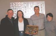
CONGRATULATIONS TO THE WINNER!
geoLOGIC systems is proud to sponsor the CSPG Technical Luncheon program. As part of the sponsorship program, geoLOGIC partnered with Natural Rocknobs for a draw of select hand-crafted stone knobs, ideal for cabinets, drawers and closets, valued at $630.
The lucky winner was Dan Wright, Geologist at Canadian Natural Resources Limited! Just in time for Dan’s renovations of his kitchen, the Natural Rocknobs will bring nature into his home.
Photo (left to right): David Hood, President of geoLOGIC systems ltd.; Maggie Hanna, Natural Rocknobs; Dan Wright, CNRL; and Kim MacLean, CSPG.
EMERGING PETROLEUM RESOURCES DIVISION
Design and implementation of field sample and data collection protocols for unconventional gas reservoirs in frontier areas
SPEAKER
Steven T.Priesmeyer TICORA Canada,Inc.
12:00 Noon Wednesday,December 10,2003
ConocoPhillips Auditorium
(3rd Floor – west side of building) 401-9th Ave SW (Gulf Canada Square), Calgary, Alberta
Unconventional gas reservoir systems present unique challenges when designing field sampling and data collection programs.Each coal and shale gas prospect must be treated distinctly and field sampling and data collection protocols designed in a casespecific manner.It is critical that field sampling and data collection protocols are well designed and that field personnel have a sound understanding of them because sampling and data
collection are time-sensitive and opportunities can easily be lost.
Reservoir depth and geometry,quality of stratigraphic control,and gas storage and movement characteristics help determine the sample recovery method. Conventional core recovery is suitable for well-defined reservoir systems at shallow depths with good stratigraphic control and slow desorption characteristics.Wireline core recovery is suitable for broadly defined reservoir systems with poor stratigraphic control and fast desorption characteristics.
Reservoir composition,thermal maturity and,to a lesser extent,gas storage and movement characteristics affect the treatment of the samples once they are collected.Low rank coals,which often have low gas contents,are susceptible to oxidation.Oxidation may completely offset desorption of methane and other gases.Water can be added to the canister to eliminate oxidation,however, clay mineralogy may preclude the addition of water to canisters containing water-sensitive shales.
If reservoir characteristics,such as reservoir temperature,are only poorly known,desorption temperature experiments must be conducted.This will allow for the correction of desorption data if more accurate temperatures become available at a later date.
BIOGRAPHY
Steve is the Vice President of both Calgarybased TICORA Canada and its parent company TICORA Geosciences.Mr. Priesmeyer has worked in several United States coal basins,including the Powder River and Raton Basins,providing geological and description services to the unconventional reservoir industry.In addition to his CBM experience,Steve has 20 years field and operations experience in mineral exploration. He has a Masters in Geology from University of Idaho,Moscow,Idaho 1986.
INFORMATION
All luncheon talks are free – please bring your own lunch.If you would like more information about future EPRD activities, please join our e-mail distribution list by sending a message with the title “EPRD list” to caddelem@bp.com.
WATER RESOURCES & ENERGY DEVELOPMENT
Abstract Submission Deadline: December 10, 2003
Registration Opens On-Line Monday, January 5, 2004
CSPG ANNUAL AWARDS
Each year the Canadian Society of Petroleum Geologists and the CSPG Educational Trust Fund present an array of awards to deserving individuals for excellence in the science of petroleum geology,distinction in the field of fossil fuel exploration,outstanding volunteerism to
CSPG AWARDS AWARDNAME
Stanley Slipper Gold MedalRobert Yurkovich
RJW Douglas MedalClint Dahlstrom
President's AwardWayne Foo
Link AwardGerry Reinson
Honorary MembershipRobert D.Orr James K.Gray
Medal Of MeritB.A.Zaitlin
M.J.Warren D.Potocki
L.Rosenthal R.Boyd
Tracks AwardsMark Cooper
Peter Hay
Glenn Karlen
Service AwardsJack MacMillan
Stefan Bachu
Selena Billesberger
Tim Bird
Dave Brown
Nathan Bruder
James Burns
Marc Charest
Doug Flaig
Karen Greengrass
DougHamilton
Pat Jans
Gary Johannson
Don Keith
James Lamb
Bob Leatherbarrow
Bob MacDonald
Jack McMillan
Mazhar Qayyum
Ralph Rudser
Malcolm Shaw
Lousie Shaw
Chris Tanglis
Kent Wilkinson
Cheryl Wright
the Society and the Trust Fund,and exemplary academic performance at the graduate and undergraduate levels.The CSPG Executive Committee and the Board of the Educational Trust Fund take great pride and pleasure in presenting those geoscientists,explorationists,and
CSPG
AWARDS (...Continued) AWARDNAME
Volunteer AwardsChuck Buckley
Dean Bull
Sean Callaghan
Steve Cliff
Greg Dyble
Lori Ennis
Jim Gardner
John Gordon
Penny Gray
Steve Haysom
Debbie Horbachewski
Nathan Humphrey
Karl Jors
Dave Kisilevsky
Jurgen Kraus
Aaron Leblanc
Tim Loehr
Blythe Lowe
Dianne Martin
Vern Mathison
Derrick McClure
Brian McKinstry
Kevin Meyer
Lori Meyer
Stuart Mitchel
Rachel Newrick
Paul Piovoso
Jack Porter
Garry Prost
Scott Rose
Asma Saleem
Wendy Sheir
Stacia Skappak
Nadya Slemko
Gillian Stoyko
Dave Swaggar
Scott Trollope
Kendal Umscheid
Jennifer Unterschutz
Krista Walker
Wallace Wells
Jay Williams
Richard Wong
Colin Yeo
CSPG Special AwardsJim Stenhouse
students receiving awards for 2003.Their service and excellence stand as testaments to the strength of the profession and as beacons for the remainder of us to follow.
Congratulations and well done!
CSPG EDUCATIONAL TRUST
FUND AWARDS AWARDNAME
Andrew D.Baillie Award - Paper Asgar-Deen
Andrew D.Baillie Award - PosterCholach Pavlo
Region Grad Scholar - WestLori Meyer
Region Grad Scholar - Central Silvia Mancini
Region Grad Scholar - EastShawna Weir
Reg Undergrad Scholar - WestTashia Dzikowski
Reg Undergrad Scholar - Central Geoffrey Newton
Reg Undergrad Scholar - East Lila Dolansky
PhD Thesis AwardTBA
PhD Thesis Honorable MentionTBA
MSc Thesis AwardTBA
MSc Thesis Honourable MentionTBA
CAST AwardKeith Diakiw
J.B.Webb Award - GradTBA
J.B.Webb Award - UndergradTBA CSPG TrophyTBA
CSPG Undergrad AwardsClaude Farley
Cara Lynn Donnelly
Michael Hay
Jeffrey Beirnes
Emily Delahaye
Christine Tong
Sarah White
Ben Hollands
Dawson Brisco
Conor Doyle
Greg Niebergall
Anne McIntyre
Olivier Beaulieu
Pamela Campbell
Heather Hunt
Peter VanEngstrom
Marc- André Chen
Reagan Porter
Simon Auclair
Andre Dunford
Dayna Linley
Jane Elizabeth Hawken
Andrew Nimno
Andrea Kruger
Kim Robinson
Lynn Reich
Erin Oickle
Dominic Ranieri
DATE: January 13-15,2004
EVENT: Dolomites:The Spectrum - Mechanisms,Models, Reservoir Development - 3-Day Seminar and Core Conference (A CSPG Seminar)
LOCATION: Calgary,Alberta
INFORMATION: ONE-DAY SEMINAR
Invited speakers for the seminar are:Lawrence Hardie,The Johns Hopkins University (keynote*); Dave Morrow,Geological Survey of Canada;Taury
2003/2004 CALENDAR OF EVENTS ROCK SHOP
Smith,New York State Reservoir Group;Fiona Whittaker,University of Bristol;Noel James and Kurtis Keyser,Queen's University;Jack Wendte, Geological Survey of Canada.
It is anticipated that there will be 25 core/sample/poster presentations of dolomite case histories,ranging from the Cambrian
Art Silver B.Sc. art.silver@lidarservices.ca (403) 517-3132 “Using laser technology for 3-D earth surface mapping” www.lidarservices.ca
Tony Tubman P.Eng. tony.tubman@lidarservices.ca (403) 517-3131
Cathedral Fm.to the Triassic Baldonnel Fm.
Material on the Ordovician (Red River) and Silurian (Interlake) will be on display and the Devonian and Mississippian will be thoroughly represented.The organizers have attempted to solicit examples that encompass the spectrum of dolomitization models.All presentations will remain available for viewing for the two days of the conference.
REGISTRATION: Online only,available December 1st,2003,for both Seminar and Core Conference,or either event:Cap 250 registrants. Fees:$375 (members),$475 (non-members).
DATE: March 19-20,2004
EVENT: Water Resources & Energy Development - William C.Gussow Geoscience Conference (A CSPG Seminar)
LOCATION: Raddison Hotel,Canmore,Alberta
INFORMATION: SESSIONS:
Water resources for petroleum exploration and production (Dr.Kevin Parks,Alberta Geological Survey - Chair);Resources for waterfloods,steam generation,etc.
Resource Conflict (Dave McGee,Alberta Environment - Chair):Industrial impacts on surface and shallow groundwater resources.
Handling and disposal of produced water (Dr.Ian Hutcheon,University of Calgary - Chair); Coalbed Methane waters,co-produced freshwaters from shallow gas,SAGD produced water,treatment and compatibility,disposal of acid gases into aquifers,etc.
KEYNOTE SPEAKERS:
Dr.Marios Sophocleous,Kansas Geological Survey
Dr.Bill Gunter,Alberta Research Council
Dr.David Percy,Dean of Law,University of Alberta
Applying Innovative Petrography to Resolve Depositional and Structural Controls on Reservoir/Play Development in Devonian and Mississippian Dolostones and Limestones.
Over 40 Projects Completed in W. Canada
Over 40 Projects Completed in W. Canada Web: www.dravisinterests.com Phone: 713-667-9844
CALL FOR POSTERS:
Oral talks will be by invitation only.However delegates are welcome to submit abstracts for poster presentations pertaining to the subject of the three main themes of the conference.Deadline for abstract submission is December 10,2003.For more information,registration,and electronic submission of abstracts contact Lori Humphrey-Clements at (403) 264-5610,Ext.202 or email to lori@cspg.org.
DATE: April 18-21,2004
EVENT: AAPG Annual Convention
LOCATION: Dallas,Texas
INFORMATION: For more information visit www.aapg.org
DATE: May 10-13,2004
EVENT: 2004 CSEG National Convention Theme:Great Explorations – Canada and Beyond
LOCATION: Calgary,Alberta
INFORMATION: For more information visit www.csegconvention.org
INFORMATION: For more information watch the Reservoir and CSPG website.
DATE: September 19-22,2004
EVENT: ICAM 2004,8th International Congress on Applied Mineralogy
LOCATION: Aguas de Lindoia,Brazil
INFORMATION: For more information contact EPUSP,Av.Prof. Luciano Gualberto,Trav.3,nº 380,05508-900,Sao Paulo,SP,Brazil;(55) 1130915420;fax (55) 38145909;www.icam2004.org.
The CSPG’s Continuing Education Committee has been revived after a period of dormancy.The renewed committee comprises Krista Walker,Ken Waunch,Chad Harris,Dave Russum,and Godfried Wasser.
A REVIEW OF PAST ACTIVITIES CONCLUDED:
1. That instructors were often considered to be teaching courses on a part-time and volunteer basis. Consequently,they were poorly compensated for their work resulting in a reluctance to initiate new courses through the CSPG.
2. Presenting quality courses with a strong relevance to the Canadian industry requires considerable expertise and work on the part of the instructors,particularly in respect to course materials and course notes.
CSPG VOLUNTEER COORDINATOR
If you are looking for a volunteer opportunity within the CSPG,Blythe will be happy to help you find your volunteer niche.
She can also provide information about any of the Society’s numerous committees if you require it.
Blythe will also assist with finding replacements for current committee volunteers who need a change and help them to find different volunteer opportunities in the Society,if desired.
Blythe Lowe can be reached in Calgary at 403-290-3516. Give her a call!
With industry demanding more productivity from its workers,less time is available for instructors to present courses to our membership on a volunteer basis.
3. Training programs and corporate commitment to training for both junior and senior personnel has declined considerably in recent years.Employees are expected to be experts in their field and to do their professional development in their spare time and, sometimes,at their own costs.
The committee feels,that to maintain a skilled geological work force,we have to address these issues.Canadian geologists are relatively cheap compared with their international peers.This combined with extensive databases and state of the art software makes us one of the most productive and affordable workforces on the planet.Supporting a revived continuing education program should be
an Industry priority;especially since demographics suggest we will lose a significant number of experienced geoscientists over the coming decade.
Furthermore,despite the best efforts of earth sciences departments at our universities,many geologists entering the petroleum industry require introductory courses pertinent to Canadian petroleum geology.These are not readily available.
Based on these market conditions,two committee members (Godfried Wasser and Dave Russum) outlined a mandate for the committee that was presented to the CSPG executive in early October 2003.
THE FOLLOWING SUMMARIZES OUR RECOMMENDATIONS:
1. Our initial focus will be on providing new courses that go beyond basic skills
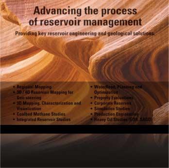
Advancing the process of reservoir management
and have a strong Canadian relevance and content.We note that developing such courses is less attractive to instructors since there is no market for these courses outside Canada.
2. We will look at ways to help new geologists develop basic skills by developing training guidelines, providing information on available courses,identifying additional needs, and seeking innovative ways to provide course material.
3. We will investigate and seek membership feedback into whether there are ‘distance learning’ or ‘Elearning’ methods and opportunities that could benefit our membership. We propose to poll the membership on these and other training issues.
5. We will encourage the creation of new courses,by providing instructors with an arrangement that fairly compensates them for their efforts.
WE ARE CURRENTLY CONSIDERING THE FOLLOWING COURSES:
• Courses to address new developments in clastic and carbonate sedimentology.
• A course/fieldtrip on the regional setting and reservoir quality of the Belly River Group.
• A course on the origins and identification of sedimentary structures.
4. We will attempt to offer courses at prices in line with Industry standards so that we do not undercut other training initiatives.However,discounts of approximately 25% will be offered to CSPG members – ‘Membership has its privileges’.
• A review of the Western Canada Sedimentary Basin along the lines of the former CSPG Advantage Program.
We need your feedback regarding training needs,your interest in presenting a specific course that is not currently available to industry,your interest in receiving or presenting training through electronic media,as well as your interest in joining our committee.
PLEASE CONTACT US:
Godfried Wasser (godfried.wasser@cnrl.com) Phone 1-403-514-7458
Dave Russum (dave@geohelp.ab.ca ) Phone 1-403-813-4457
JACK PORTERVIGNETTES OF CANADIAN PETROLEUM GEOLOGY
The Extraordinary Odyssey of R.
G. McConnell
With Richard McConnell ensconced in the Hudson’s Bay Company’s Fort Providence for the approaching winter of 1887-1888,an opportunity presents itself to digress from the narrative of his odyssey to focus on the role played by the aforementioned company in obtaining knowledge of the existence of Great Slave Lake and the Mackenzie and Slave Rivers.Such information was gleaned by the Hudson’s Bay Company prior to the North West Company’s incursions into these regions,commencing in 1785 by Pond, Grant,and Leroux.
The first European to have visited Canada’s Arctic Ocean,Great Slave Lake, and Slave River by an inland route was Samuel Hearne.In 1766,at the age of 21 years,he joined the Hudson’s Bay Company as an experienced seaman and was posted to Fort Prince of Wales (Fort Churchill) on the Hudson’s Bay where he was slated for ship duty.Here,in 1767,he was assigned as mate on the Company’s sloop Churchill where she was engaged in trading expeditions to the Eskimo inhabiting the northwest coast of Hudson’s Bay.The following year Hearne served as mate on the sloop Speedwell in the hunting of whales along the Bay’s coast.Finally,in 1769,he was transferred to the brig Charlotte (Glover,Richard G., The Beaver,March,1947;Sidelights on Samuel Hearne,p.11).
Samuel Hearne enlisted in the Royal Navy at 11 years of age as a boy seaman – a recruitment practice by the British Navy common during the 18th and 19th centuries.His tenure of duty was during the Seven Years War as a Captain’s servant on two man-of-war frigates under the distuished command of Captain Samuel Hood,who later was titled Admiral Lord Hood.Hearne’s early tour of duty was in the English Channel and Bay of Biscay,with his last four years spent in the Mediterranean theatre.It was the knowledge and experience that Hearne had acquired while in the Royal Navy that
qualified him as a ship’s mate at such a young age (Ibid.,p.11).
Moses Norton,the Metis son of Governor Richard Norton,had replaced his father as governor of Fort Prince of Wales at the time of Samuel Hearne’s arrival.The new governor was acknowledged by both his subordinates and natives alike as a salacious and selfserving scoundrel.
Accounts of copper “mines”,located near the mouth of the river discharging into a northern sea,had been reported to Hudson’s Bay traders at Fort Prince of Wales by Chipewyan (Northern) natives arriving at the fort as early as 1719.Moses Norton’s preoccupation with his selfaggrandizement,particularly in the eyes of the Governor and comittee at Beaver House in London,led him to set about obtaining copper samples from the
reputed “mines”.Accordingly,he dispatched two Chipewyan natives, Matonabbee and Idotliazee,to conduct the search on his behalf.After four years of cumulative travel across the Barrens,they arrived back at Fort Prince of Wales on August 9,1767 with representative specimens of native copper,proof that their quest had been successful in reaching the Coppermine River and its associated copper “mines”.Moreover,the two natives,as instructed by Moses Norton, returned with a crude map of the country they had traversed.It had been drawn with charcoal on a deerskin hide.Norton was elated and,armed with the copper specimens and a pencil tracing on paper of the original map’s features,he left for London the following year to meet with the Governor and his committee (1785;A Journey to the Northern Ocean by Samuel Hearne -- A Journey from Prince of Wales
Continued on Page 22 ...
ROCK CREEK RESERVOIR WORKSHOP
March 22
April 5 - 8
Detailed stratigraphy, sedimentology, reservoirs and play types for all internal formations. What part of the Mannville will you work next year?
$1399.00. 10% discount for 3 or more.
HOW TO CORRELATE LOGS
May 10
Methods for correlating shoreface sands, marine and non-marine cycles, recognition of unconformities and channels, using markers and datums.
RECOGNITION OF CLASTIC RESERVOIR FACIES
May 11
Core examples of all Alberta Basin sandstone and conglomerate reservoir facies-criteria for recognition, reservoir geometries.
JURASSIC-CRETACEOUS PETROLEUM GEOLOGY AND PLAY TYPES, ALBERTA BASIN
May 12
Petroleum geology of clastic reservoir units. Traps, reservoirs, and play types
REGISTRATION FOR 3 METHODS COURSES: $549.00 each. 10% discount for 3 or more. Entire package $1399.00.
BOOK CLIFFS FIELD SEMINAR: ANALOGS FOR CANADIAN RESERVOIRS
The world’s best outcrops of fluvial, shoreface and shelf sands. Reservoirs, s and facies relationships on an exploration/development scale. Comparison of outcrops to Canadian examples and well-log exercises. equence stratigraphy,
10% discount for 3 or more.
Reservoir facies and geometries, picking Rock Creek vs. Mannville and Upper Jurassic sands, J sands, how to correlate and map Rock Creek sands, correlation exercises, how to recognize internal unconformities, exploration strategies : $699.00. REGISTRATION10% discount for 3 or more. For information / registration, call Doug Cant (403) 949-3810, email cantd@telus.net
Sept 19 - 26
Fort in Hudson’s Bay to the Northern Ocean in the Years 1769,1770,1771,1772; ed.Glover,Richard,1958,introd.vi,vii,viii). Significantly,a portion of this map as traced and refined by Norton clearly depicts an obvious outline of what would later be named Great Slave Lake,its North Arm, and the Mackenzie River (designated by the Cree name:Kiscahewan”),as well as the Slave and Taltson Rivers (2001,Hayes, Derek:First Crossing Alexander Mackenzie,his Expedition across North America,and the Opening of the Continent,pub.Douglas & McIntyre, Vancouver/Toronto,p.34).
The copper samples and map sufficiently impressed Governor Sir William Baker and his committee that they gave wholehearted approval for Norton to send one of his white subordinates at Fort Prince of Wales out on an overland expedition to the mouth of the Coppermine River.The main intent was to determine the river’s navigability in accessing the long-sought North West Passage to the Orient.An investigation was also to be made in respect to the location,nature,and extent of the copper occurences.Of paramount importance to this sanctioned expedition was the compilation of data,accumulated along the route,involving distances and directions between stations where celestial observations could determine accurate positions based on both latitude and longitude.Such information would later be sythesized into map form. Chipewyan names for lakes,rivers,and other physiographic features were also to be incorporated,as well as native knowledge of major lakes or rivers beyond the proposed expedition’s route.
After returning to Fort Prince of Wales, Moses Norton designated Samuel Hearne to accompany a group of Chipewyan natives to traverse the Barrens to the region of the copper “mines” and the river by the same name.
Samuel Hearne’s knowledge of surveying instruments was no doubt gained during the period he spent in the British Navy. However,whether he was instructed in their use by his superior officers is problematic.His rudimentary skill in their use probably arose through good fortune during the visit to Fort Prince of Wales on
August 10th,1768 by British astronomers, William Wales and Joseph Dymond who arrived to observe the transit of Venus.This phenomenon occurs only twice within an eight-year period every 120 years when the planet Venus passes between the sun and the earth.The scientific instruments transported from England for their precise measurements included two astronomical pendulum long-case clocks,an instrument to correct the effects of heat and cold,two quadrants for measuring the height of celestial bodies,two reflecting telescopes,a barometer,compass,and two Fahrenheit thermometers.The two scientists remained at the Fort at least until June 3rd, 1769,the day the transit occurred (GriffinShort,Rita,The Beaver,April/May.2003, pp.8,9).Samuel Hearne was stationed at the Fort during the winter of 1768-1769 since Hudson’s Bay was frozen over and his vessel,the Charlotte,was inactive.It was during this period that he probably received rudimentary training in astronomy and surveying from Wales and Dymore that would enable him to calculate measurements of longitude and latitude, while awaiting his first inland expedition.
Hearne’s first two attempts to reach the Coppermine River from Fort Prince of Wales commenced on November 6,1769 and February 2,1770.The initial effort was guided by Chawchinhaw,who,with a number of his band members,robbed Hearne of his provisions and weapons some 200 miles north of the Fort.Hearne, with a few native loyalists – destitute and starving – managed to reach the safety of Fort Prince of Wales in dire circumstances. The guide of the second endeavor,namely Conne-e-queese,proved to be an outright incompetent.He led Hearne and his party of Chipewyan natives on a confused circuitous trek which took them back in the direction of the Fort.
Moses Norton had supplied Samuel Hearne with a Hadley’s quadrant for determining latitude,which supplanted the astolabe and was the forerunner of the sextant.On August 11,1770,during the course of his second journey,his mounted quadrant was accidentally damaged beyond repair.According to Hearne:“I let the quadrant stand,in order to obtain the latitude more exactly by two altitudes;but, to my great mortification,while I was
eating my dinner,a sudden gust of wind blew it down;and as the ground where it stood was very stoney,the bubble,the sight-vane,and vernier,were entirely broke to pieces,which rendered the instrument useless.In consequence of this misfortune I resolved to return again to the Fort, though we were then in latitude of 63 degrees 10 minutes North,and about 10 degrees 40 minutes West longitude from Churchill River.” (1795;A Journey to the Northern Ocean by Samuel Hearne,ed. Glover,Richard,1958,p.29).It was this calamity that led Hearne to abort his second expedition and return to Fort Prince of Wales where he and his party, including his guide Conne-e-queese, arrived on November 25th,1770,after an absence of eight months and 22 days.
On December 7th,1770,Samuel Hearne launched his third attempt to cross the Barrens to the Coppermine River and access its course to where it discharges into the Northern Ocean and furthur,to investigate the copper “mines”.It was during a mere 12 days following his return
to Fort Prince of Wales,that he was able to address the logistics necessary for this last attempt.
Unlike the previous two failed trips, Hearne was determined that Norton would not overrule his choice of a reputable guide.As Governor of the Fort, Norton had previously preferred one of his own Company servants stationed at the Fort (home guards) as was the selection of Chawchinhaw and Conne-equeese.However,on this occasion,after much urging,Norton reluctantly acquiesed to Hearne’s insistance that he employ his friend Matonabbee as his guide leader.
Matonabbee,the offspring of a Chipewyan father and a slave Cree mother,had been raised in the Fort as a child.He,along with Idotliazee,had visited the Coppermine River and copper “mines”,probably in 1765 during their four-year journey as instructed by Moses Norton.Matonabbee’s superior intelligence and innate leadership attributes held him in high esteem amongst his Chipewyan people.
Prior to Samuel Hearne’s departure,Moses Norton assigned to him an Elton quadrant to replace the Hadley quadrant which had suffered irreparable damage during his previous expedition.The Elton quadrant was an earlier model and was to prove more cumbersome to position and transport.He was also equipped with a compass,chronometer,and declination tables – the latter to be used in combination with his quadrant observations in calculating his latitude positions.Longitude determinations,at this juncture had yet to be refined.The advent of the sextant,to resolve both latitude and longitude,was developed independantly by John Hadley and Thomas Godfrey about 1780,a decade following Hearne’s journeys.It would appear that Hearne computed the longitude of an observed latitude position by estimating the transit distance from Fort Prince of Wales whose longitude,as well as its latitude,had been established.
To be continued ...
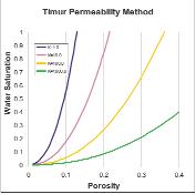
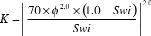
PERMEABILITY FROM OPEN-HOLE LOGS
KENNETH HESLOP, P.ENG., LOGX INC.; ALAN HESLOP, PETROPHYSICAL CONSULTANT
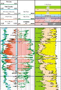
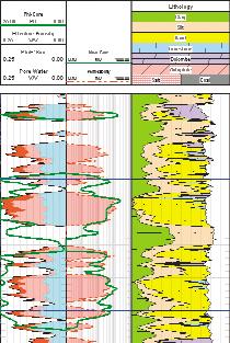
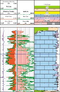
There are many direct and indirect measurements of porosity,but the permeability of a reservoir has until now been an elusive parameter.Some have attempted to use NMR technology to infer permeability,but that method requires extensive core data for calibration.The purpose of this paper is to present a method anyone can use to predict permeability in common reservoir rocks without the necessity of core data or expensive logging runs.
A couple of definitions are necessary to begin.Porosity is considered here as a measure of the pore space in the rock.This excludes the water associated with clay in shale.In petrophysics we speak of this as effective porosity.Permeability is a measure of how easily fluids can flow through the rock.Therefore both porosity and permeability are characteristics of the solid medium,the rock from which we hope to produce hydrocarbons.
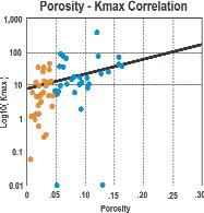
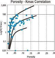
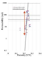
It is common to find a linear fit suggested for porosity and permeability data,such as that shown in Figure 1.Under close examination, this relationship only works well for the higher porosity data.Below 5% porosity we find one relationship does not adequately represent of permeability data.Consider that at 3% porosity this data suggests we could have a range of permeabilities from 0.5md to 50md.It does not seem reasonable to assume this range of data should be represented by one value,which would be slightly greater than 10md.
Before simply assuming the scatter of the permeability data is due to data errors, consider the proposed correlations in Figure 2. Here we see three different correlations,each defining permeability in terms of porosity at
constant water saturation.Water saturation was introduced here as a measure of relative pore size.(We will develop that relationship in greater detail later.)
Having introduced relative pore size,and therefore pore throat size,into the determination of permeability,it becomes clear that the permeability for any given porosity is a function of the pore throat size through which fluids must flow.In this example,we can see how at 6% porosity,one data trend would give a permeability of 10md,while another data trend leads to a permeability of 100md.
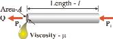
HENRY DARCY IN DIJON
Henry Darcy developed the equation for flow in 1856 while preparing a report on the water supply for Dijon,France.He expressed flow (Q) in terms of permeability,area,length, fluid viscosity,and pressure differentials.
This is illustrated in Figure 3.
Rearranging this equation,we have permeability in terms of flow.
When we consider the permeability of a reservoir,the fluid properties are constant;flow rate and pressure differential are linked,leaving permeability to be a function of area.It is then interesting to note that the unit of permeability is the Darcy,which is 9.87 * 10-9 cm2.
APPLYING THE THEORY TO ROCKS
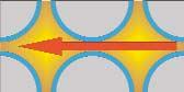
How then do we apply this theory to reservoir rocks? To begin with it is obvious we cannot either measure or calculate every pore throat in the reservoir.Every pore throat will be slightly different than the next. But we do observe different permeabilities in reservoir rocks,and hopefully we can develop a relationship to correlate the overall permeability of a formation to some reservoir property we can measure.
While it is plain that permeability in granular or crystalline rock is a function of the pore throat cross-sectional area,we don’t have an easy method to measure that area.Besides, every pore throat will be different,and permeability will be the function of the average pore throat cross-sectional area.Therefore we need a method of determining the relative pore throat area,and a relationship between that area and permeability.
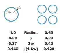
5 - Relating Pore Size to Porosity & Water Saturation.
Figure 2 - A better porosity/permeability solution.
Figure 3 - Darcy’s flow model.
Figure 1 - Common porosity/permeability fit.
Figure 4 - Permeability is a function of the pore throats,not the pore volume.
Figure
CSPG 21st ANNUAL SQUASH TOURNAMENT
21st ANNUAL SQUASH TOURNAMENT
This year’s tournament will be played at the WORLD HEALTH EDGEMONT CLUB, 7222 Edgemont Blvd. N.W., Calgary, on February 5 - 7, 2004. The emphasis is always on having fun, but there is keen competition for the serious players. From beginners through to provincially ranked players in both the men’s and women’s divisions, there is sure to be a level of play suited to you.
Maximum of 125 players, so get your entry in early to avoid disappointment!
EVENTS: Men’s & Women’s A, B, C, D, and Novice.
Open only to members of the C.S.P.G. (or an affiliated society) and their spouse or equivalent.
ENTRY FEE: $50.00 includes GST ($30.00 Students)
Fee includes two guaranteed matches (Saturday teams tourney), shirt, beer, and food during the tournament, Saturday night dinner (Please specify chicken (C), beef (B), Salmon (S) or Veggie (V)), and draw prizes. Saturday’s dinner will be held at the Edgemont Club.
Pre-tournament open squash courts, provided by Tucker, will be available January 22 and 29 from 6:00pm - 8:00pm for people to warm up their racquets at the Bow Valley Racquet Club.
Pre-tournament registration social will be at Bow Valley Racquet Club (3 Street and 5 Avenue S.W.) on Tuesday, February 3, at 5:00pm. Pick up your tournament kit and first draw time, and enjoy a free pint of Ale with munchies.
All door prize draws are Saturday evening - you must be present to win.
Extra Dinner Ticket: $30.00 for non-playing guests only. (Will be limited to 25 due to venue space).
ENTRY DEADLINE:
January 22, 2004. EARLY BIRD DRAW PRIZE for entries received prior to January 8, 2003. (No refunds after January 22, 2004). FOR FURTHER DETAILS CONTACT: Colin Thiessen 650-0086; Kent Wilkinson 699-5494; Randi Christiansen 699-5543; Andrew Royle 298-5626; Alan Rutherford 861-2643; Jessie Gould 660-2547; David Caldwell 265-8987; Chris May 645-5193; Randy Smith 263-0449; Andrea Henry 218-7333; Jolene Wood 243-0820; Ryan Barnett 781-1712.
REGISTRATION FORM:
NOTE: Games commence Thursday, February 5, 2004. All participants must be available to play after 4:30pm Thursday, Friday afternoon, and all day Saturday.
ADDRESS REGISTRATION TO: CSPG SQUASH TOURNAMENT 160, 540 - 5 Avenue S.W. Calgary, AB T2P 0M2
Please Make Cheques
It is not difficult to see that pore throat area is a function of the pore sizes – the larger the pore,the greater the radius of the pore throat. Now consider the following cases in Figure 5 (Page 26).On the left is an illustration of a large pore,while on the right are four smaller pores. The pores on the right were drawn to represent pores containing the same total volume as the one large pore on the left.In both cases the thickness of the irreducible water layer is the same (0.1 units,) but the fraction of the pore volume occupied by water (Sw) is significantly different.Combining porosity and water saturation gives us an indication of relative pore size.Here we use (1Sw) because we are interested in the volume not filled with water.Thus we have a measure of relative pore size,but is that enough to resolve the relationship to permeability?
CONSIDERING THE DATA
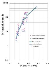
Theory will only take us so far,and then we need to look at real data.For this we have combined two special core analysis reports into one data set.The first special core analysis is from the east coast of Canada,and the other from Africa.Both were from shaly sands.Figure 6 presents this data on a typical porosity versus permeability cross-plot.
The hazards of using a porosity/permeability relationship are very clear here.A “Best Fit” through this data might suggest the permeability at 22 percent porosity should be 30md.But the data shows a range of permeabilities at that porosity from 3 to 300md.The range of error is too great for this relationship to be acceptable.
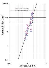
Applying what we have observed regarding relative pore size,we find that the data trend
(Figure 7) becomes much narrower.It would be rather simple to determine a polynomial or power relationship for this data – but which one best represents the data? In seeking an answer to this,we discovered a log10 function of the x axis left us with a linear data trend.(Figure 8)
where:
Kis the permeability, φ the effective (non-shale) porosity, Swiis the irreducible water saturation.
Simplifying this equation we can write:
A linear trend is much easier to represent in an equation,and the range of error in permeability is consistent at all porosity values.Here we fit the overburden permeability data to arrive at the following relationship:
We now have permeability as a function of porosity and water saturation.This relationship is based upon the assumption porosity and irreducible water saturation combined give us the relative pore size,and therefore an indication of the average pore throat size.Since permeability is a function of area through which fluids must flow,we can reasonable expect this relationship to apply in any intergranular or intercrystalline reservoir.
A simple graph representing this permeability relationship in terms of porosity and water saturation is shown in Figure 9.By entering the x axis with the effective (non-shale) porosity1,and the y axis with the water saturation,the reader is able to predict the range of permeability to expect.
From this cross-plot we can identify the expected permeability given porosity and water saturation.Thinking back to Darcy’s original work we see that with constant pressure and fluid properties,the maximum flow rate is defined by the cross-sectional area of the tube.It should not surprise us then to find there is a maximum
1Effective Porosity is defined in petrophysics as the volume of pore space available to contain both hydrocarbons and formation water,but excluding any water associated with clay.Likewise we define Total Porosity as the total pore volume,including the water associated with clay.The raw porosity log is a measure of Total Porosity.In clean carbonates total and effective porosity are the same,but not in shaly sands.
Figure 7 - Relating relative pore size (the product of porosity and (1-Sw),) to permeability.
Figure 9 - Heslop permeability relationship.
DOLOMITES: THE SPECTRUM – MECHANISMS, MODELS, RESERVOIR DEVELOPMENT
JANUARY 13-15,2004
JANUARY 13
TELUS CONVENTION CENTRE
JANUARY 14 & 15
AEUB CORE RESEARCH CENTRE
HONOURARY CHAIR
Eric Mountjoy
Graham Davies Geological Consultants Ltd.
Jeff Packard
Burlington Resources Canada
The first of the CSPG’s Fall / Winter Core Conferences is “Dolomites – The Spectrum:Mechanisms,Models,Reservoir Development”,to be held in Calgary January 13-15,2004.The conference will have two components:a one-day lecture Seminar with invited speakers,and a twoday Core Conference.
The Seminar will be held at the Telus Convention Centre with the Core Conference being held the following days at the AEUB Core Research Centre.The invited speakers for the seminar with their affiliations and titles are listed in table one.
A reception will follow the Seminar on Tuesday evening maintaining the momentum of the day and providing attendees with an opportunity to continue discussion while mingling.
The Core Conference will display over 20 case studies on dolomite,both domestic and international,reservoir and non-reservoir. Subsurface to outcrop formations represented include Cathedral,Red River, Interlake,Keg River,Manetoe,Presquile,Slave Point,Swan Hills,Leduc,Nisku,Wabamun, Banff,Pekisko,Midale,Debolt,and Baldonnel. Field examples from the Canadian Arctic, Caymen Islands,and Australia will also be on display.All presentations will be displayed for the full two days.
The invited speakers’ abstracts and core conference expanded abstracts/presentations will be compiled on a CD and will be available with conference registration.Depending on results,there may be opportunity for formal publication at a later date.
Registration is available on-line only (at www.cspg.org follow links) and is limited to 250 participants,at a fee of $375 for CSPG members and $475 for non-members. Registration includes a CD of Abstracts, lunch on Tuesday (Seminar),Wednesday and Thursday (Core Conference) as well as the reception on Tuesday evening at the Telus Convention Centre.
The committee gratefully acknowledges the sponsorship of Calpine Corporation,Core Laboratories,and the AEUB – Core Research Centre.
For further information,contact the CSPG office 264-5610.
Fault-related hydrothermal dolomitization:why it is and should be common.
An early dolomitization realm:Cenozoic and modern dolomite in calcite sediments, southern Australia.
From conceptual to numerical models of dolomitization.
Evolution of porosity in dolomite – critical review of dolomite porosity relationships and new ideas on processes.
Sponsored
Table 1 – List of invited Speakers.
WILLIAM C. GUSSOW GEOSCIENCE CONFERENCE
WATER RESOURCES & ENERGY DEVELOPMENT
MARCH 19 – 20,2004
RADDISON HOTEL & CONFERENCE CENTRE, CANMORE, ALBERTA
The CSPG is resurrecting the "Banff Conference" style of single topic miniconference in the early part of the year. These will be an annual series of two-day mini-conferences on specialized topics,at a location close to Calgary to minimize travel time and expenses.An excellent way to seed this conference series is through the CSPG Technical Divisions. The size of the events will vary with the topics,though we contemplate a relatively small group of 150 - 250 participants,and will attract top-notch speakers.
The first such conference,scheduled for March 19 – 20,2004 will be on the role of water resources and hydrogeology in energy development.The idea is to examine water issues that are related to energy resource development –resource availability for heavy oil and bitumen steam floods,coalbed methane produced water disposal,aquifer and surface water contamination issues,as well as aspects of conflict over water use in areas of limited supply.
RESOURCE CONFLICT
(Dave McGee,Alberta EnvironmentChair): Industrial impacts on surface and shallow groundwater resources.
KEYNOTE SPEAKER
Dr.David Percy,Dean of Law,U of A: “Canadian Approaches to Industry and Water “
SESSION SPEAKERS
Lorne Terns, LOB
“Native Consultation and Water”
Steve Wallace,Hydrogeologist,AMEN
“The Water Act and Conflict Resolution”
TBA
Butte Action Committee
“Landowners,Industry and Water”
WATER RESOURCES FOR PETROLEUM EXPLORATION AND PRODUCTION
(Dr.Kevin Parks,Alberta Geological Survey - Chair); Resources for waterfloods,steam generation,etc.
KEYNOTE SPEAKER
Dr.Marios Sophocleous, Kansas Geological Survey
SESSION SPEAKERS
Brenda Austin,AEUB “Oilfield Use of Surface Water and Groundwater in Alberta,An Overview”
Dr.Allan Crowe, NWRI/Environment Canada “Impacts of Oilfield Development on Groundwater Quality - The National Experience”
John Fennel,Komex Intl.Ltd: “Integrated Surface Water and Groundwater Resource Investigations for Heavy Oil Development,Alberta”
HANDLING AND DISPOSAL OF PRODUCED WATER
(Dr.Ian Hutcheon,University of Calgary - Chair); Coalbed Methane waters,co-produced freshwaters from shallow gas,SAGD produced water, treatment and compatibility,disposal of acid gases into aquifers,etc.
KEYNOTE SPEAKER
Dr.Bill Gunter, Alberta Research Council.
SESSION SPEAKERS
TBA
* Check the website for updates on more guest speakers!
CALL FOR POSTERS
While the sessions will be by invitation only,delegates are encouraged to submit abstracts for poster presentations pertaining to the subject of the three main themes of the conference.Details for submitting a poster are available on the CSPG’s webpage (www.cspg.org). Follow the links to the Gussow Conference.The deadline for abstract submission is December 10,2003.
SPONSORSHIP:
For more information on Sponsorship opportunities contact: Reghan Ottenson (403) 333-6077 or Kim Maclean,CSPG Corporate Relations Manager (403) 264-5610 ext.205.
REGISTRATION
Registration will open Monday,January 5 on-line via www.cspg.org (follow the links to the Gussow Conference).The fee is $300 plus GST and includes lunches and the Friday banquet reception.
For more information and regular updates,visit www.cspg.org or contact the CSPG Office at (403) 264-5610.
CONFERENCE ORGANIZING COMMITTEE
Stephen Grasby, Geological Survey of Canada, Natural Resources Canada,Co-Chair
John Cody, Encana Corporation,Co-Chair
Phil Esslinger, Rakhit Petroleum Consulting,Co-Chair
Dion Lobreau, Talisman Energy,Marketing/Promotion
Reghan Ottenson, SafetyBOSS,Sponsorship
Lori humphrey-Clements, CSPG Convention Manager
permeability for any given porosity.That maximum is reached when water saturation approaches zero.
Permeability equations are generally based upon two assumptions:the first that an intergranular or intercrystalline pore system exists;the second that the formation is at irreducible water saturation. With the exception of production due to fractures,it is reasonable to assume the intergranular or intercrystalline pore system controls permeability in most shaly sand and carbonate formations.In certain cases the vugs in carbonates will have a greater influence than the intercrystalline pores,and this relationship will no longer apply.When dealing with carbonates in general,water saturations should be corrected through the use of a variable cementation exponent “m” to correct the resistivity for the effects of vugs,or other such pore types.
REAL-LIFE EXAMPLES
In an example from the Northwest Territories (figure 10),we see how core porosity and total porosity track.This is because the helium used to measure porosity can even penetrate into the clays.The effective porosity only approaches core porosity in the cleanest sands.As a result, permeability measured in the core for these shaly sands tends to be slightly higher than we predicted from logs.In this core even the shale has permeability reported.
Our second example comes from a well in the east of Africa (figure 11).
This is a short interval from a very extensive section of log and core data.Once again we observe that core porosity is equal to total porosity,while effective porosity in the clean sands approaches to core porosity.Notice here how closely the log permeabilities match the Kmax.We did not have Kvertical from this core.But Kvertical and Kmax are generally very close in sands.
Our last example (figure 12) comes from the Golden Spike field.This limestone reef was extensively cored,but here we show just the top 70m of the reef.
In this limestone reef we observe how well the log porosity matches the core porosity. But when we compare the permeabilites,it becomes clear the Kmax data are slightly higher than the log permeabilities.Kvertical, however,matches the log permeabilites very well.
REVIEW OF OTHER METHODS
This is not the first method proposed to calculate permeability from porosity and water saturation.Two permeability relationships that often appear in the literature are those proposed by Timur and Coates, respectively.Each of these deserves evaluation.
The Timur relationship was given as:
When plotted in terms of porosity versus water saturation,this relationship takes the form shown in Figure 13.
Similarly the Coates permeability relationship was given as:
This relationship was likewise plotted in terms of porosity and water saturation in Figure 14 (Page 36).
Both of these relationships have appeared frequently in the technical literature. Thoughtful examination will note that both of these permeability relationships suggest formations can have very high permeability,in the range of 1000md or more,in very low porosities,and in particular when the water saturation is less than 5%.Theoretically,if we could remove all of the formation fluids,the permeability should be directly related to the
Figure 10 - IOL Taglu G-33.
Figure 11 - An example out of Africa.
Figure 12 - Golden Spike 15-23-051-27W4.
Figure 13 - Timur permeability relationship.
average pore throat diameter,and the number of pore throats available for fluid flow in the sample.The presence of formation water has the effect of reducing the effective pore throat diameter,and thus the permeability.However,the inconsistency noted in these relationships is generally not of practical significance,since we seldom find irreducible water saturations less than five %.
Of greater significance is the assumption in the Timur relationship that high permeability can exist in formations with high irreducible water
saturations.In Figure 13 (Page 34),it is evident this relationship would result in 100 md of permeability in reservoir rock with 30% porosity,and 67% irreducible water saturation. Experience has shown these porosity and saturation conditions are representative of a chalky limestone.Chalk is seldom thought of as a highly permeable formation.
Above 30% irreducible water saturation the Coates and Heslop relationships are in close agreement.The window of agreement between the Timur relationship and the other two is very small.In general,use of the Timur relationship results in higher permeabilities than would be obtained from either of the other two.
CONCLUSIONS
Accepting the assumption of an intergranular or intercrystalline pore system,and that the formation is at irreducible water saturation,it is possible to obtain meaningful permeability data from well logs.The permeability equation developed in this paper has been tested and compared to core permeability data in both shaly sand and carbonate reservoirs in many areas of the world.It has consistently provided reliable results.
We know permeability in fractured rock will be much higher for any given porosity,
because fluid flow is not restricted by the pore throats.At the same time we know core porosity data in very shaly sands and siltstones are not representative of the effective porosity.Permeability data obtained from these cores tends to be optimistic.
While acknowledging the limited data set used in developing this relationship – this data did not include low porosity and permeability data – our experience has shown this relationship works across the entire spectrum of porosity and permeability data.The data set used here exhibited good linear behavior in a tight trend.It is then reasonable to extrapolate this data to predict permeability in lower porosity clean rocks, where the pore systems are similar to these intergranular rocks.Experience has confirmed this confidence.
BIOGRAPHIES
Kenneth Heslop – A consulting petrophysicist for the past 20 years with experience in most oil and gas producing regions of the world.Graduated from the U of Calgary with a BSc.in Mechanical Engineering in 1980.(kenneth.heslop@logx.ca)
Alan Heslop – A Petrophysical Consultant and an Honorary Member of APEGGA for his work in Petrophysics.