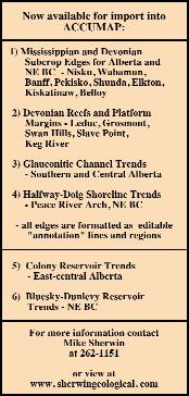
SEISMIC GEOMORPHOLOGY: Base Cretaceous Unconformity - Alberta
CSPG OFFICE
#160,540 - 5th Avenue SW
Calgary,Alberta,Canada T2P 0M2
Tel:403-264-5610 Fax:403-264-5898
Email:cspg@cspg.org Web:www.cspg.org
Office hours:Monday to Friday,8:30am to 4:00pm
Business Manager:Tim Howard
Email:tim.howard@cspg.org
Office Manager:Deanna Watkins
Email:deanna.watkins@cspg.org
Communications Manager:Jaimè Croft
Email:jaime.croft@cspg.org
Conventions Manager:Lori Humphrey-Clements
Email:lori@cspg.org
Corporate Relations Manager:Kim MacLean
Email:kim.maclean@cspg.org
EDITORS
Please submit RESERVOIR articles to the CSPG office.Submission deadline is the 23th day of the month,2 months prior to issue date.(ie:January 23 for the March issue).
To publish an article,the CSPG requires both hard and electronic copies of the document.Text should be in Microsoft Word format and illustrations should be in TIFF format.For additional information on manuscript preparation, refer to the Guidelines for Authors published in the CSPG Bulletin or contact the editor.
COORDINATING EDITOR & OPERATIONS
Jaimè Croft
CSPG
Tel:403-264-5610 Fax:403-264-5898
Email:jaime.croft@cspg.org
TECHNICAL EDITOR
Ben McKenzie
GEOCAN Energy Inc.
Tel:403-261-3851
Email:bjmck@telusplanet.net
ADVERTISING
All inquiries regarding advertising and technical specifications should be directed to Kim MacLean.The deadline to reserve advertising space is the 23th day of the month,2 months prior to issue date.All advertising artwork should be sent directly to Kim MacLean at the CSPG.
The RESERVOIR is published 11 times per year by the Canadian Society of Petroleum Geologists.This includes a combined issue for the months of July/August.
Advertisements,as well as inserts,mailed with the publication are paid advertisements.No endorsement or sponsorship by the Canadian Society of Petroleum Geologists is implied.
The CSPG Rock Shop is an attractive and affordable way for advertisers to present their services to the CSPG Readership.Spaces are sold at business card sizes (3.5” wide by 2” high) and will eventually fill an entire Rock Shop page. For more information or to book a space please contact Kim MacLean at 403-264-5610,ext.205.
The contents of this publication may not be reproduced either in part or in full without the consent of the publisher.
Design & Layout by McAra Printing Printed in Canada by McAra
CORPORATE MEMBERS
THE CSPG GRATEFULLY ACKNOWLEDGES ITS *CORPORATE MEMBERS:
ABU DHABI OIL CO., LTD. (JAPAN)
ARCHEAN ENERGY LTD.
BURLINGTON RESOURCES CANADA ENERGY LTD.
CALPINE CANADA
CANADIAN FOREST OIL LTD.
CONOCOPHILLIPS CANADA RESOURCES LIMITED
DEVON CANADA CORPORATION
DOMINION EXPLORATION CANADA LTD.
ECL CANADA
EL PASO OIL & GAS CANADA, INC.
HUNT OIL COMPANY OF CANADA, INC.
IHS ENERGY
IMPERIAL OIL RESOURCES LIMITED
LARIO OIL & GAS COMPANY
MJ SYSTEMS
MURPHY OIL COMPANY LTD.
NCE RESOURCES GROUP INC.
NEXEN INC.
NORTHROCK RESOURCES LTD.
PENN WEST PETROLEUM LTD.
PETRO-CANADA OIL AND GAS
SAMSON CANADA
SHELL CANADA LIMITED
SPROULE ASSOCIATES LIMITED
SUNCOR ENERGY INC.
TALISMAN ENERGY INC.
TOTALFINAELF E&P CANADA LIMITED
UPTON RESOURCES INC.
*CORPORATE MEMBERS AS OF FEBRUARY 24, 2003
To the CSPG Membership:
Many geologists in the Calgary area have had the pleasure to become acquainted with Laurie Wilcox at the Core Research Centre (AEUB).Late last year,we urged our membership to help financially support Laurie for constructive surgery on her jawbone.Unfortunately this major corrective operation (total bill - $20,000) was not covered by Alberta Health Care.
We are pleased to inform you that we successfully raised the funds (Friends of Laurie) for her surgery.She had her operation on January 29.Her prognosis for complete recovery is good.We can't thank the members of the society enough for their generous support.You have made a real difference in Laurie's life.
Sincerely
Iain Muir,Shelley Moore,Caroline Williams,and Richard Brandley 247-2140
To All my friends,
I would like each and every one of you to know how much I appreciate your kindness, prayers, concerns as well as your generosity due to the circumstances with my mouth surgery. The donations to the Trust Fund are very remarkable and I am very grateful to the many friends that I have in the Oil Industry, many personal friends and co-workers. It is so good to know considerate people who try to help others in all that they do, people whose lives show the meaning of kindness. You are very special people and always will be a very special family to me.
MANY, MANY THANK YOU'S FROM THE BOTTOM OF MY HEART TO ALL OF YOU GREAT PEOPLE.
The services portfolio is comprised of reward and recognition,social events,public affairs,and corporate relations.The majority of outreach activities have been successfully shifted to the Educational Trust Fund in the last year or so.The challenge in Services is really to focus on developing and promoting benefits of membership in the Society to existing members,as well as working towards expanding our membership base throughout all of Canada and abroad.To assist in this endeavour many of you participated in the CSPG survey on-line last fall (Thank you!). The purpose of this survey was to make certain that we understand what the members expect and want from the CSPG,as well as to ensure that our members are getting value and satisfaction from their CSPG membership.Patrick Elliot and Bill Cox (Co-Chairs of the membership committee) will be presenting the results of the survey in an upcoming reservoir.Thank you,Bill and Patrick,for coordinating the survey.
The CSPG Educational Trust will be providing sponsorship in 2003 for the following programs:1) Calgary Science Centre’s Invent-an-Alien Program (February, 1st,2003);2) The GeoSciEd IV Program: “Earth Science for the Global Community” (August 15th,2003);3) The Canmore Geoscience Centre’s ‘Stones and Bones’ Summer Program,and 4) The EdGeo National Earth Science Workshop Program.
The Calgary Science Centre’s Invent-an-Alien program integrates story writing and alien models to provide all students who participate with the opportunity to understand basic science concepts in a fun way.During the GeoSciEd IV Program,CSPG volunteers George Eynon,Brad Hayes and Bill Martindale,
A MESSAGE FROM THE SERVICE DIRECTOR
with the help of staff at the Alberta Energy and utilities Board (AEUB) core research facility, will coordinate two separate half-day core seminars (one session for K-12 and one session for post-secondary teaching professionals).This will provide a unique opportunity for geoscience teachers to examine,first hand,the actual rock from which oil and gas are produced.Cores will be selected to show participants the two main types of reservoir rocks:clastics (sandstones) and carbonates (coral reefs,etc).CSPG volunteers will outline their significance in the development of the oil and gas industry, describing the cores,identifying their depositional environments and geological settings,and illustrate their presentations with well logs,cross-sections,maps,and diagrams. This is the first time this program is being held in Calgary.Previous conference have been held in Australia;Hawaii,USA;and the United Kingdom (for more information,see www.geoscied.org).The Canmore Geoscience Centre’s ‘Stones and Bones’ Summer Program. This program is designed to introduce 10- to 12- year-old children to geology through exhibits and field trips of geological interest. The EdGeo Workshop Program,coordinated by the Canadian Geoscience Council (CGC), organizes educational workshops across Canada to provide Canadian elementary and high school teachers with curriculum-relevant, hands-on activities for the earth science components they are required to teach (for more information,see www.edgeo.org).
On a final note,as I enter my final year on the CSPG Executive,I have a much better appreciation for the amount of volunteer time and effort that individuals and committees contribute to the success and character of the CSPG.Thank you to all those who choose to be involved with the many activities of the CSPG.If you are looking to volunteer within the CSPG,please contact Blythe Lowe (Volunteer Coordinator) at (403) 290-3516 or a member of the CSPG Executive.
Lisa Sack Services Director
APRIL LUNCHEON
The History of a New Play: Thunder Horse Discovery,
Deepwater Gulf of Mexico
SPEAKER
Cindy A.Yeilding BP,Houston,Texas
11:30 am
Thursday,April 10,2003
TELUS CONVENTION CENTRE CALGARY, ALBERTA
Please note:
The cut-off date for ticket sales is 1:00 pm,Monday,April 7.
Ticket price is $25.00 + GST
The Thunder Horse discovery is an accumulation of over one billion barrels of oil in the deepwater Gulf of Mexico.This test challenged traditional exploration philosophies in the GoM and led to the discovery of a new play.After early success in the amplitude-driven deepwater play, pool sizes were declining and success rate was flat at best.After multiple exploration failures in the conventional attributedriven play,we adopted a 'back to basics' exploration philosophy which focused on the geologic elements of the basin.We also focused on exploring from the source rock up.These concepts changed the way we viewed prospectivity in the GoM and steered us towards targeting older stratigraphic intervals in previously untested deeper structures.
Regional work indicated that the Mississippi Canyon protraction area was a top place to focus our exploration efforts. Existing discoveries proved the presence of a world-class petroleum system and showed that large structures with significant fetch areas were present.Our subregional analysis focused on highgrading structural features with the best fetch areas and welldeveloped reservoir.The analysis indicated that the Boarshead Basin in south central Mississippi Canyon held promise as a top area to test this new play concept and two structures were prepared for testing.Both prospects were turtle structures with primary targets in Miocene strata.
Before we could drill,several major hurdles had to be overcome.The acreage position had to be secured,and rigs with the ability to drill in these water
depths had to be obtained.Three-D seismic surveys and depth-imaging breakthroughs were required to describe the prospect elements and position a well.Depth imaging was especially important,as it provided a much better structural image for prospect description and well positioning.When we finally tested the two top prospects in the play,one (Thunder Horse) was successful and one (MC 911-1) was a failure.Post-appraisal of these wells helped us understand the potential and risks of this new play,although each new well in the play continues to teach us new lessons and keep us humble.
The process of continued focus has led us to this success.In building a regional framework for the northern Gulf of Mexico basin,we were able to focus our subregional analysis on interpreted sweet spots that we were constantly highgrading.While the regional and subregional work were very efficient in terms of cost and time,prospect maturation and drilling were extremely cost- and team-intensive.
BIOGRAPHY
Cindy Yeilding earned her MSc in 1984 from the University of North Carolina.She has been employed by BP for 18 years and is currently the Global Geoscience Technology Manager for the Upstream Technology Group in Houston,Texas.She has developed and led short courses and field seminars in deepwater clastic systems in the US and Canada,salt/sediment workshops,and basic petroleum geoscience.She has also chaired numerous AAPG sessions,presented over 20 AAPG/SPE/GCSSEPM talks,and participated in Hedberg conferences.Her primary research has been in salt sediment interactions and her recent focus has been in exploration of deepwater clastic deposystems,with development,access,and testing of new plays.
CSPG VOLUNTEER COORDINATOR
If you are looking for a volunteer opportunity within the CSPG,Blythe will be happy to help you find your volunteer niche.
She can also provide information about any of the Society’s numerous committees if you require it.
Blythe will also assist with finding replacements for current committee volunteers who need a change and help them to find different volunteer opportunities in the Society,if desired.
Blythe Lowe can be reached in Calgary at 403-290-3516.Give her a call!
The cut-off date for ticket sales is 1:00 pm,Monday,April 21.
Ticket price is $25.00 + GST
Antarctica has controlled glacial eustasy throughout most of the Neogene.This talk will provide a review of the evidence for Antarctic glaciation in the Cenozoic and a discussion of the glacial eustatic control on global stratigraphic architecture.The most recent glacial eustatic cycle, which is by far the best documented,is used to understand those factors that regulate ice sheet expansion and decay.In summary,future changes in the volume of the ice sheet and its potential impact on civilization by coastal flooding are discussed.
BIOGRAPHY
John B.Anderson graduated in 1968 with his B.S.in Geology from the University of South Alabama.He then went on to receive his M.Sc.in Geology from the University of New Mexico in 1970 and he received his Ph.D.in Geology from Florida State University in 1972.John was an Assistant Professor at Hope College in Holland,Michigan from 1972 to 1975.Since 1975,John has been a professor at Rice University in Houston,Texas where he has held various positions including Department Chair from 1992 to 1999.John is currently the Maurice Ewing Professor of Oceanography.
John is involved with the study of Marine Geology and Sedimentology in Antarctica as well as the Quaternary Evolution of the Northern Gulf of Mexico Basin.These studies have involved 21 scientific expeditions to Antarctica and the Gulf.John is involved with the AAS-Polar Research Board,AGUAntarctic Research Series,the AAPG,and is currently President-elect for the Society for Sedimentary Geology.John has also authored and co-authored 120 refereed publications and three books.
PARTNERS in
ENVIRONMENT
2003 CSPG / CSEG Convention Round Up Centre, Stampede Park June 2-6, 2003 Calgary • Alberta • Canada
For more information visit www.cspg.org or www.cseg.ca
Gas Hydrates in Canada:
Overview of recent research activities by the Geological Survey of Canada and Partners
SPEAKER
Scott R.Dallimore Geological Survey of Canada
AUTHORS
Scott R.Dallimore
Geological Survey of Canada
Kirk Osadetz
Geological Survey of Canada
11:30 am Thursday,May 8,2003
TELUS CONVENTION CENTRE CALGARY, ALBERTA
Please note:
The cut-off date for ticket sales in 1:00 pm,Monday,May 5. Ticket price is $25.00 + GST
Gas hydrates are crystalline substances composed of water and natural gas,in which a solid water lattice accommodates gas molecules in a cage-like,clathrate structure.Gas hydrates are widespread in permafrost and marine settings.The basic geologic conditions required for their formation include cold temperatures, intermediate pressures (generally >3 MPa hydrostatic pressure),suitable reservoir conditions (porosity and permeability),and a source of natural gas.The amount of natural gas occurring in the form of gas hydrate is enormous;however,estimates
are speculative and range over three orders of magnitude,from about 2,800 to 7,600,000 trillion cubic meters.Research interests in gas hydrates have focussed on three themes:gas hydrates as a future energy source;gas hydrates as a geohazard, both to conventional oil and gas exploration and in relation to marine slope instability;and gas hydrates as a possible natural source of greenhouse gas influencing global climate change.
Over the past decade the Geological Survey of Canada (GSC),working with a variety of partners,has conducted regional studies of gas hydrates in Canada. Concentrated occurrences of gas hydrates have been identified offshore of Vancouver Island and in association with thick permafrost in the Arctic Islands and Mackenzie-Beaufort region.A number of dedicated gas hydrate research wells have also been completed.Most notably,in 1994,Leg 146 of the Ocean Drilling Program investigated gas hydrates in the Cascadia margin,offshore of Vancouver Island.Research well programs,each with dedicated scientific and engineering objectives,were completed at the Mallik gas hydrate field in the Mackenzie Delta in 1998 and 2002.The most recent program at the Mallik site included the first modern production testing of gas hydrates.
The GSC has recently begun a national gas hydrate research program to advance energyrelated gas hydrate research in Canada and to assess environmental/geohazard issues that may be related to possible development.This talk will give a brief overview of gas hydrate science,the distribution of gas hydrates in Canada,and an assessment of key research needs for the future.
KEEPING TRACK
SCOTT HADLEY
New: Senior Geologist Fairborne Energy Ltd. Calgary Alberta
Pr evious: Consultant – Manager Exploration Range Energy Inc.
Calgary, Alberta
BIOGRAPHY
Scott Dallimore has worked as a research scientist at the Geological Survey of Canada since 1984.His background is in geological engineering and geotechnical science,having completed a Bachelors degree at Queens University and a Masters degree at Carleton University.Scott has spent most of his career working in the Mackenzie Delta/Beaufort Sea area on a wide variety of research topics from permafrost to pipeline engineering.His work on gas hydrates began in 1992 when a permafrost research program with the GSC/Shell and Imperial Oil collected the first gas hydrate core samples from a permafrost occurrence.Since that time,he has led two large,research-well programs at the Mallik field in the Mackenzie Delta.
Mr.Osadetz is a graduate of the University of Toronto,Ontario (B.Sc,,1978;M.Sc.1983).He is the Manager of the ESS Gas Hydrates – Fuel of the Future? Program and Head,Energy and Environment Subdivision at the Geological Survey of Canada’s Calgary Office.Energy and Environment Subdivision has national responsibility for organic geochemistry,organic petrography and hydrocarbon and coal resource assessments,and regional responsibility for environmental geoscience,particularly as related to the impact of fossil fuel production and consumption.He leads the national program of hydrocarbon resource evaluation for Canada as well as having research interests related to the characterization of hydrocarbon systems Canadian sedimentary basins, particularly the Williston Basin,Intermontane Basins,and the Foreland of the Western Cordillera.Before joining the Geological Survey he worked in Calgary as a geologist in the exploration departments of Gulf Canada Resources Inc.and PetroCanada Resources Inc.
CALL FOR PHOTOGRAPHS
The CSPG Geological Calendar is one of the most visible and enduring manifestations of the Society in the professional lives of its members;for an entire year this publication graces the walls of offices across Canada, reminding members of their affiliation to the best geological organization in the country. Daily it serves to let members know what is going on in the Society and provides space for personal calendar items as well;it lets us know when our conventions are,what Tech Lunches are coming up,and how long until the Squash Tournament;it highlights the major events in our organization and the more significant ones of our sister societies like the AAPG,CSEG and the GAC…..but what most folks look for,as with any calendar, are the pictures.Over the years we’ve covered virtually every geological feature in Canada,plus a quick overview of the Society’s legacy last year during our 75th Anniversary.
Once more we are looking to you,the members,to dreg through your photo archives
for the best and most interesting images you have taken and share them with your peers.
This year’s calendar will be receiving an even wider distribution,as we continue exporting it beyond the CSPG into both universities across Canada and,for the first time,schools in the Calgary area.This is the first step in using our Calendar as a voice for the Society and the geosciences in the Canadian community at large…but we need your help to ensure that we continue to have real punch with the product we are distributing…and this means images with punch as well.
This year we are going to do something else different,in the hopes of stimulating member participation.The Calendar Committee is offering a prize of one year’s free membership in the CSPG for the photograph chosen as the best by the judging panel.The subject matter is not confined to the landscapes that have dominated the calendar
for years.We would also like to see close-ups of rock textures and fabrics,thin-section photomicrographs,and anything else geological that you find interesting.The only proviso is that the photo be of Canadian rocks.We have lots of stunning rocks in this country – let’s show them off! Considering many of our members come from different parts of the country,it would also be nice to see better representation of the vast areas outside of Alberta and the West,such as the Maritimes,Ontario,and Quebec.So come on, shutterbugs! Glory and a free membership await you.Let’s see what you’ve got!
Submissions should be sent to the CSPG office by not later than June 30th.
Gary Johannson Chair,Calendar Committee
MAY LUNCHEON
Jackpine Creek Magnetic Anomaly:Identification of a Buried Meteorite Impact Structure
SPEAKER
Serguei Goussev
Geophysical Exploration & Development Corporation (GEDCO)
AUTHORS
S.A.Goussev,R.A.Charters, J.W.Peirce,W.E.Glenn
Geophysical Exploration & Development Corporation (GEDCO)
11:30 am Thursday,May 22,2003
TELUS CONVENTION CENTRE CALGARY, ALBERTA
Please note:
The cut-off date for ticket sales in 1:00 pm,Monday,May 19. Ticket price is $25.00 + GST
Buried meteorite impact structures/craters can be very good petroleum prospects. Steen River in Alberta (~1,000 BOPD,~35 MMCF/d),Viewfield in Saskatchewan (27 MMbbl),Ames Holes in Oklahoma (18 MMbbl,14 BCF),Red Wing Creek in North Dakota (40-70 MMbbl) are examples of oiland-gas fields producing from buried impact craters.The meteorite impact process is quite remarkable as it can create a trap-generating structure (rim and, frequently,central uplift) and reservoir rock (ejecta piles and breccia infill),both at the same time.
GEDCO’s processing of new highresolution aeromagnetic (HRAM) data reveals a circular magnetic anomaly at Jackpine Creek,British Columbia. Geological and geophysical evidence – including isopach maps from formation tops in wells,a 2-D seismic line and forward magnetic modeling – is consistent with identification of this anomaly as a magnetic signature of a buried meteorite impact structure.
The Wapiti HRAM survey was flown by Fugro Airborne Surveys with 600 X 1,800 m line spacing at an average height of 200 m above the ground.Standard preprocessing provided the reduced-to-pole
Total Magnetic Field grid.This grid was processed with various signal enhancement techniques.The 3-6 km band-pass filter reveals a nearly circular,negative magnetic anomaly.The “shallow” version of the cascaded Goussev filter shows a distinct oval-to-circular positive anomaly.
Since filtered magnetic maps suggest the magnetic sources of the anomaly are located within the upper sedimentary section,several isopach maps were constructed over this interval.The Bluesky-to-Cadomin isopach reveals a circular area defined by a decrease in thickness at center and increase in thickness at periphery.The magnetic anomaly on the cascaded filter map correlates with the isopach thickening.
A 2-D seismic line over the SW area of the anomaly reveals components of a buried crater in the Bluesky-Cadomin interval. Estimated displacement across rim faults is about 80-100 m.Rim-to-rim diameter of the crater is about 22-24 km,with depth of occurrence at about 2,500 m below the surface.The estimated time of impact is after Cadomin but before Bluesky deposition.
A 2-D magnetic forward model constructed from the seismic interpretation shows a trough of 0.7 nT on a 3-6 km bandpass filter profile and a peak of 0.12 nT/m on the cascaded Goussev filter profile above rim faults.These values correlate quite well with the observed data.
The results of this study show that 1) HRAM survey is a cost-effective way to prospect regionally for buried impact craters and 2) HRAM survey data is sensitive to magnetic anomalies generated by faults where offsetting magnetized formations may have throws as small as 80-100 m at depths to 2,500 m.
BIOGRAPHY
Serguei Goussev graduated from the Moscow State University,Russia.He worked as a geophysicist in the western Pacific region,Arctic Siberia,South Yemen,and Moscow before joining GEDCO in 1996.Since then,he has been working mostly with high-resolution aeromagnetic and airborne gravity data.
“...worthy of attending either as an exhibitor or viewer.”
Time is running out! Don’t miss your chance to reserve your company’s booth! And don’t forget to purchase yourviewer passes!
EXECUTION
The Discipline of Getting Things Done
ROCK SHOP
STRUCTURAL DIVISION
The Lewis and related Front Ranges Thrusts;leading edge of a composite crystalline thrust sheet
SPEAKER
Philip Simony
Department of Geology and Geophysics,University of Calgary
12:00 Noon Tuesday,April 8,2003
+30 (3rd floor) ConocoPhillips Conference Centre (inside Sunterra Market), Gulf Canada Square, 401 - 9th Avenue SW. Calgary, Alberta
Modelling of thrust belts requires understanding the relationship of thrusts in the foreland to deformation in the orogenic core.Mid-crustal levels exhumed in the hinterland of the southern Canadian Rocky Mountains expose ductile shear zones linked to foreland thrusting.The Valhalla core
complex in southern British Columbia consists of an upper plate,deformed in the Middle Jurassic,and a lower plate in which the Middle Jurassic record is overprinted by pre-mid-Cretaceous intrusions,metamorphism,and shear –perhaps linked to pre-mid-Cretaceous thrusting in the Purcells and western Rockies.The Gwillim Creek shear zone (GCSZ) lies at the base of the lower plate.East-directed thrust-type ductile shear on it is associated with a 78 Ma pegmatite swarm and 76-67 Ma metamorphism.The base of a 63 Ma quartz-monzonite sheet in the hanging wall of the GCSZ was strained while still hot.These ages correlate well with ages on the Lewis,Rundle,and related thrusts in the Front Ranges.Northward loss of motion on these thrusts is one cause for northward decrease in shortening of the Rockies.This may correlate with the disappearance of ~70 Ma metamorphism northwest of the Monashee Mountains. The Lewis Thrust is the major thrust at the leading edge of a composite crystalline sheet more than 400 km wide
across strike.Its motion was facilitated by drastic reduction in shear strength at its base as a consequence of metamorphism, melting,and pegmatitic fluids in the orogenic core zone.There may be links between the thermal and fluid flow regime of the foreland with that of the hinterland.
BIOGRAPHY
Educated at McMaster University and the Imperial College (University of London), Philip has taught for 39 years at the University of Calgary.He has undertaken structural mapping in the southern Rockies and in the ranges that lie to the west in southern British Columbia.
INFORMATION
There is no charge.Non-members of the CSPG are also welcome.Please bring your lunch.Deserts are provided by Norwest Laboratories.Beverages are provided by HEF Petrophysical.For details or to present a talk in the future,please contact Luc Lalonde at 403645-5528,e-mail:Luc.Lalonde@EnCana.com or Eric Hanson at 403-233-3250,email: Eric.S.Hanson@conocophillips.com
EMERGING PETROLEUM RESOURCES DIVISION
Fiery Ice from the sea: Submarine gas hydrates
SPEAKER
Dr.Ross Chapman University of Victoria
12:00 Noon
Wednesday,April 9,2003
+30 (3rd floor) ConocoPhillips Conference Centre (inside Sunterra Market), Gulf Canada Square, 401 - 9th Avenue SW. Calgary, Alberta
Submarine gas hydrates are ice-like solids that form in sediment pore spaces under specific conditions of temperature, pressure,and concentration of hydrocarbons.Hydrates occur world-wide along continental margins and in polar regions,and large deposits are known to exist offshore Vancouver Island in the North Cascadia Margin.Although the submarine hydrates represent a large potential hydrocarbon resource,accidental
release dissociation of large volumes of hydrates could raise the level of greenhouse gas content in the atmosphere. Seismic surveys have established the areal extent of hydrates through detection of the bottom simulating reflector (BSR) that indicates the base of the hydrate stability zone in the sediment column.Offshore Vancouver Island,BSRs occur at about 220250 m below the sea floor and the analyses of the seismic data have provided an estimate of the quantity of gas in the hydrates.The seismic surveys have also revealed the presence of seep sites at the sea floor that are associated with pathways for upward migration of methane-rich fluids.Physical and chemical analysis of hydrates from cores taken at the seep sites indicates that most of the submarine hydrate is biogenic.A new discovery of large quantities of seafloor hydrate in Barkley Canyon has indicated that some of the hydrate on the margin is of themogenic origin,and may be associated with conventional oil and gas reservoirs in the Tofino Basin.Seafloor sediments at the
Barkley Canyon seep site contain light oil, suggesting that the hydrocarbon venting and seepage is very vigorous.This talk reviews the present status of our understanding of the Cascadia Margin hydrates and discusses possible geohazards associated with resource recovery.
BIOGRAPHY
Dr.Chapman is Professor and Senior Chair in Ocean Acoustics at the School of Earth and Ocean Sciences at UVic.He joined the University in 1995 after a career of 20 years in Ocean Acoustics at Defence Research in Victoria.His research interests are in methods for inversion of acoustic field data for estimating geophysical properties of the ocean bottom and,in particular,its application to submarine gas hydrates.
INFORMATION
All luncheon talks are free – please bring your own lunch.If you would like more information about future EPRD activities, please join our e-mail distribution list by sending a messages with the title “EPRD list” to caddelem@bp.com.
STRUCTURAL DIVISION
Enhanced Fluid Flow in Critically Stressed Fractures, Implications for Reservoir Permeability
SPEAKER
Balz Grollimund
GeoMechanics International Palo Alto,California
12:00 Noon
Thursday,May 1,2003
+30 (3rd floor) ConocoPhillips Conference Centre (inside Sunterra Market), Gulf Canada Square, 401 - 9th Avenue SW. Calgary, Alberta
Many aspects of producing hydrocarbons from fractured reservoirs rely on a thorough understanding of fracture permeability. Optimizing drainage of fractured reservoirs requires understanding of the distribution and orientations of permeable fractures.Preexisting fractures in the earth’s crust generally evolve over geologic time as the result of multiple episodes of deformation.Although ”conventional wisdom” says that fractures have a preferred orientation in a given
reservoir,they usually are found to be at a wide range of orientations.Furthermore, according to the results from a case study in the Monterey formation in Central California, the commonly held view that “open” fractures (mode 1) provide pathways for fluid migration does not appear to be applicable.Rather, episodes of shear displacement create increased permeability,which is maintained with continued deformation,thereby sustaining open conduits for fluid migration. Therefore,fractures optimally oriented for shear failure in the present day stress field are more likely to be permeable than fractures that are poorly oriented with respect to the present-day stress field.
Wellbore images provide fundamental data for assessing fracture permeability and reservoir optimization.Fracture orientation and distribution can be directly determined from image logs.In addition,wellbore image logs provide information about drilling induced compressive and/or tensile wellbore failure,from which information on the present-day in situ stress state can be derived. Using the knowledge of the stress field in combination with the determined fracture orientations,the resolved shear and normal stress on each fracture can be determined and evaluated for proximity to slip.A
PALAEONTOLOGY DIVISION
Drumheller marine tongue fauna
SPEAKER
Dr.Wayne Haglund
Mount Royal College
7:30 PM
Friday,April 25,2003
Mount Royal College Room B108
4825 Richard Road SW Calgary, Alberta
Allan and Sanderson (1945) originally described the Drumheller marine tongue as it occurs in Horseshoe Canyon as consisting of a lower one meter of arenaceous limestone characterized by Crassostrea subtrigonalis,a middle six meters of siltstone and an upper one meter arenaceous
limestone characterized by Corbicula ventricosa.Current field studies suggests that it can be found 35 kilometers north of Drumheller and south to near Scabby Butte, Alberta within the Horseshoe Canyon Formation.My emphasis will be on the occurrence along the Red Deer River Valley south to the Rosebud River.
Coquinas occur above coal bed #9 in the south and below coal bed #11 in the north. The well-cemented coquinas consist of approximately 40% shell material and approximately 60% clay and volcanic ash.In the north,they occur as a single bed nearly a meter thick.In the extreme southern portion of the study area,several coquinas occur stacked;the vertical distance between coquinas ranges from 0.5 to 6.0 meters.
The oyster Crassostrea subtrigonalis dominates the fauna of the Drumheller marine tongue.
correlation between high fluid flow and critically stressed fractures has been documented in a variety of reservoirs worldwide.Knowing the orientations of permeable fractures can be used to optimize well trajectories such that a maximum amount of permeable fractures is intersected.
BIOGRAPHY
Balz Grollimund is working as a geomechanical consultant for GeoMechanics International (www.geomi.com),a consulting company headquartered in Palo Alto,CA.He received a diploma (equivalent to M.S.degree) in Structural Geology from ETH in Zurich,Switzerland in 1996 and his M.S.degree and Ph.D.in Geophysics from Stanford University in 1999 and 2000,respectively. During his Ph.D.in the stress and crustal mechanics group of Mark Zoback he was studying the in situ state of stress offshore Norway and its implications for fault seal integrity.
INFORMATION
There is no charge.Non-members of the CSPG are also welcome.Please bring your lunch. Deserts are provided by Norwest Laboratories. Beverages are provided by HEF Petrophysical.For details or to present a talk in the future,please contact Luc Lalonde at 403-645-5528,e-mail: Luc.Lalonde@EnCana.com or Eric Hanson at 403233-3250,e-mail:Eric.S.Hanson@conocophillips.com
C.subtrigonalis appears to be very responsive to local environmental conditions and is thus manifested in the form of several ecophenotypes.Relatively small,thin-shelled ecophenotype representing supertidal environments;moderate-sized,thick-shelled ecophenotype representing intertidal environments;and relatively large,thickshelled ecophenotype representing subtidal environments.Modern ecophenotypes of Crassostrea virginica appear in brackish water environments,such as estuaries,salt marsh tidal channels,and some bays.
Associated with Crassostrea subtrigonalis are the bivalves Mya (A.) simulatrix,Corbicula ventricosa,Corbicula occidentalis,Modiolus galpinianus,Brachidontes dichotoma,Anomia perstrigosa;the gastropod Euspira obliquata; and the bryozoans Eokotosokum bicystosum and Villicharixa lintonensis
The distribution of the various faunal members and the nature of their valves varies as follows:
1) Crassostrea subtrigonalis – scarce, relatively small,worn,disarticulated valves in the northern portion of the study area;very abundant,relatively large,un-abraded,disarticulated and articulated valves in the southern portion of the study area.
2)Corbicula ventricosa – abundant,unabraded,articulated valves in the northern portion of the study area; scarce,relatively larger,un-abraded, disarticulated and articulated valves in the southern portion of the study area.
gastropod E.obliquata ,and the bryozoans E.bicystosum and V. lintonensis are generally found associated with the larger ecophenotypes of C.subtrigonalis
Based on the composition and conditions of the faunal material I interpret the Drumheller marine tongue to represent a series of local coquinas that are dominated by C.subtrigonalis and are the result of several marine transgressions of short duration into the Drumheller Estuary.The absence of any fully marine fauna in the Drumheller marine tongue suggests (to me) the reworking and redistribution of the shell material was by storm waves within the Drumheller Estuary and not any transgression of marine waters (and fauna) into the estuary.
David G.PopowichAssociate
Dino ZelantiniTaurus ExplorationAssociate
Jamie L.PandachuckShaker Resources Inc.Associate
Monica H.ScrivenerPromax Energy Inc.Associate
Rob BurleyGlobal Link Data Solutions Inc.Associate
Willim A.Silk,Jr.Double Star Energy Canada CorpAssociate
Ali ZulfiqarMoh & Associates Oilfield ConsRegular
Amelia M.WrightChemostrat Inc.Regular
Benjamin J.CrutchfieldHusky Energy Inc.Regular
Bill McCloskeyCompton Petroleum CorporationRegular
Brendan B.O'ConnorNexen Inc.Regular
Brian McKinstryCalver Resources Inc.Regular
Don G.HarvilleCore Laboratories CanadaRegular
Douglas P.Leyden Exxonmobil Exploration Co.Ltd.Regular
Robert P.DanielsAnadarko Canada CorporationRegular
Roger J.BakerEnterra Energy CorpRegular
Ryan M.JohnsonMegaladon Consulting Ltd.Regular
Sandra J.MartineauDevon Canada CorporationRegular
Shaheen A.KhanEnerplus Global Energy Regular Management Company
Sheldon A.GraberBMO Nesbitt Burns Inc.Regular
Stephen A.SonnenbergEnCana Oil & Gas (USA)Regular
Tim R.DavidsonCanadian Natural Resources Ltd.Regular
Timothy A.WilliamsEnCana CorporationRegular
BIOGRAPHY
Wayne Haglund has been teaching geology at Mount Royal College for nearly 35 years. He obtained his bachelor degree from Portland State University,Masters degree from the University of Kansas and is completing a Ph.D.from the University of Queensland.His interests in Paleontology are eclectic;currently they are Cretaceous brackish-water bivalves and gastropods.
INFORMATION
Talks are free and are jointly presented by the Alberta Palaeontological Society,Mount Royal College,and the CSPG Paleontology Division.For details or to present a talk in the future,please contact APS Program Director Philip Benham at 403-691-3343 or programs@albertapaleo.org.Visit the APS website for confirmation of event times and upcoming speakers:http://www.albertapaleo.org
W.Henry LickorishRegular
Aaron GrimeauUniversity Of CalgaryStudent
Chris CoueslanBrandon UniversityStudent
Colin ZwickerAcadia UniversityStudent
Cynthia HagstromUniversity Of AlbertaStudent
Dawn BrakeBrock UniversityStudent
Elaine K.WoUniversity Of CalgaryStudent
Flavia NunesUniversity Of TorontoStudent
Friederike E.BaumeisterUniversity Of CalgaryStudent
Garnet Jon KnoppUniversity Of CalgaryStudent
Geoff N.AndersonUniversity Of CalgaryStudent
Giselle LabrieUniversity Of CalgaryStudent
Heather A.MitchellUniversity Of CalgaryStudent
Jennifer KennedySimon Fraser UniversityStudent
Jichun ZhangBrandon UniversityStudent
Jolane D.SorgeUniversity Of CalgaryStudent
Justine SaganMcGill UniversityStudent
Karen BedardUniversity Of OttawaStudent
Kelsey J.JewettUniversity Of AlbertaStudent
Kristin CzyzUniversity Of CalgaryStudent
Lynette C.WopnfordUniversity Of CalgaryStudent
Mandy MillerUniversity Of AlbertaStudent
Melissa FloreUniversity Of WindsorStudent
Melissa RotellaUniversity Of VictoriaStudent
Micheal DorlandUniversity Of Western OntarioStudent
Norman J.AimeUniversity Of ManitobaStudent
Ryan MohrUniversity Of SaskatchewanStudent
Scott RaynerSt.Francis Xavier UniversityStudent
Scott T.RainvilleUniversity Of ReginaStudent
Sean A.BosmanUniversity Of Western OntarioStudent
Shovik SenguptaUniversity Of WaterlooStudent
Stacia McLeodUniversity Of CalgaryStudent
Stephen D.BiggDalhousie UniversityStudent
Tim C.McCullaghBrandon UniversityStudent
Torry BlakeUniversity Of GuelphStudent
SEDIMENTOLOGY DIVISION
Early Cenozoic tectonostratigraphic evolution and sedimentology of the Eureka Sound Group, northeastern Ellesmere Island, Nunavut
SPEAKER
Carmen Lee
University of Reading / Canadian Natural Resources Ltd.
12:00 Noon, Tuesday,April 29,2003
Encana Amphitheatre
2nd Floor, east end of the Calgary Tower Complex
1st St. and 9th Avenue SE, Calgary, AB
The Eureka Sound Group clastics on northeastern Ellesmere Island make up over 3km of strata,of Late Palaeocene age based on palynomorph assemblages,and were deposited within a braidplain to alluvial fan and
alluvial plain depositional environments. Abundant decimetre-scale trough crossbedded channel deposits characterise the oldest unit,which is the coarse-grained volcanic-rich sandstones of the Pavy Beds. Boulder polymictic orthoconglomerates typify the alluvial fan deposits of the Cape Lawrence Formation.These grade into the Cape Back Formation which consists of fine-grained calcarenites deposited within a floodplain environment. The Pavy Beds are distinct mappable,lithostratigraphic units and therefore recommended to be raised to formation status.
The mineralogy reflects the changing nature of the tectonic regime resulting from the movements between Canada and Greenland during the Late Palaeocene.Beginning in the earliest part of the Late Palaeocene,sea floor spreading of the Labrador Sea initiated left lateral strike-slip motion between Canada and Greenland.Volcanism associated with this rifting event is recorded by the dominance of undegraded,bimodal alkali volcanic lithic fragments making up the Pavy Beds.The source of these sediments is probably somewhere to the east where Nares Strait now lies.
By the latest Late Palaeocene,sea floor spreading ceased and a shift in the tectonic regime from transtention to compression occurred.This resulted in the deposition of alluvial sediments of the Cape Lawrence and Cape Back Formations within the footwalls of northeast-striking thrust faults.Clasts of the alluvial fans were derived from the adjacent Cambrian to Devonian carbonate and siliciclastic hanging-wall strata to the west and northwest.
Overall,the Eureka Sound Group strata were transported a short distance and deposited rapidly from high relief source areas under a semi-arid to arid temperate climate,and were probably buried up to 3 km at a maximum temperature of around 100˚C.
INFORMATION
Please note that there has been a venue change. Talks are free – don’t forget to bring your lunch!
For more information about this talk,or about presenting a talk,please call Scott Leroux at (403) 645-2419,(email:Scott.Leroux@EnCana.com).
EXPLORATION AND TECHNOLOGY UPDATE
SEISMIC GEOMORPHOLOGY – NEW TRICKS FOR AN OLD DOG
BY HENRY W. POSAMENTIER
Henry’s paper on seismic geomorphology represents the first of a series of articles that will be published in the CSPG Reservoir under a new section entitled “Exploration and Technology Update” .Reservoir readers are encouraged to submit short articles that focus on new exploration ideas or technological advances that are relevant to petroleum exploration on Canada.We are currently looking for articles on the following subjects:
1) very shallow gas plays in WCSB (i.e.,Quaternary,Edmonton,Bluesky,etc.);
2) hydrocarbon potential of the Mackenzie Corridor;
3) coal bed methane plays in WCSB;and
4) the remaining frontier of the fold and thrust belt in NE B.C.
We also plan to publish your comments and suggestions on previous articles.
Your contributions should be sent to Zeev Berger (tel:[403] 216-1845) by email at zeev@iitech.ca.For document format details,
please see the Guidelines for Authors published in the CSPG Bulletin or contact one of the Reservoir’s editors.
INTRODUCTION
The discipline of geomorphology has a long and illustrious history,popularized by William Morris Davis and Albrecht Penck during the latter part of the eighteenth century and early part of the twentieth century.The study of the origin and evolution of landforms initially was based on comprehensive field studies that were primarily qualitative and descriptive in nature.The discipline evolved through the years,progressively becoming more quantitative and gradually embracing other forms of data relevant to landform evolution,such as air photos and satellite imagery.
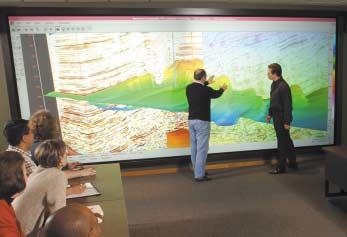
In recent years,an entirely different approach to the study of landforms has evolved.It involves the use of seismic data – specifically 3D seismic data.The use of these data has transformed the role of geomorphology from that of academic interest to a study that can significantly lower exploration and development risks associated with the prediction of the presence,as well as spatial
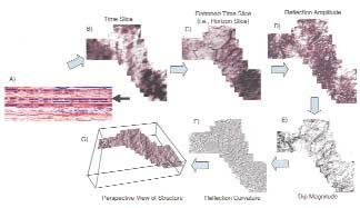
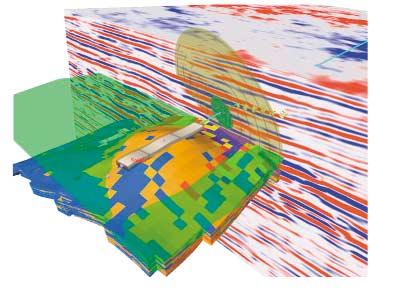
Figure 1.
A) Seismic traverse through Devonian section of northern Alberta.The arrow indicates the level at which fluvial channels can be observed.B) Time slice from the level indicated by the arrow in A).Note the linear anomalies, suggestive of fluvial channels.C) Time slice relative to a horizon datum approximately 50 msec below target level. This horizon slice reveals the presence of a drainage network across the area.D) Amplitude extraction from the horizon at the level of the fluvial channels.E) Dip magnitude display of the fluvial channel horizon.F) Curvature map of the fluvial channel horizon.Geomorphic principles suggest that the parallel aspect of this drainage network may be associated with syndepositional tectonism.G) Fluvial channel horizon shown in three-dimensional perspective view.
distribution,of reservoir,source,and seal. These data are well adapted not only to a static analysis of landforms – in other words the study of “snapshots” of the earth’s surface at a moment in time – but also to the dynamic analysis of these landforms. Understanding the lithologic significance of imaged depositional elements can add an entire new dimension to the vital prediction of what lithologies are present,to what extent,and what their quality might be from a reservoir characterization perspective.The key to successful application of geomorphologic principles to exploration lies in integrating plan view-based interpretations (i.e.,geomorphology) with section viewbased interpretation (i.e.,stratigraphy) and, subsequently,calibration with borehole data (i.e.,the rocks!).
3D seismic data enable the geoscientist to image successions of landscapes as they evolved through time.Such data constitutes the earth science equivalent of a CAT scan, providing a volume-based source of data that can be “sliced and diced” in any way the interpreter chooses.There are a variety of different ways of imaging depositional or geomorphic elements.These include 1) time
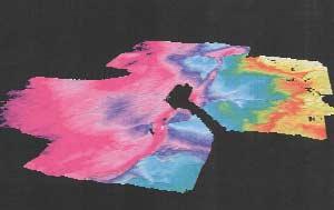
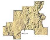
Figure 2.
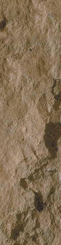
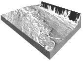
Three-dimensional display of base Cretaceous unconformity,Alberta.Lighting from the northwest direction reveals a high-sinuosity fluvial channel at the unconformity surface.
slices,2) flattened time slices or horizon slices,3) interpretation of discrete horizons, 4) characterization of stratigraphic intervals, 5) correlation of voxbodies,and 6) opacity rendering or subvolume detection.
TIME SLICES AND HORIZON SLICES
Time slices and horizon slices are excellent for initial reconnaissance through a 3D volume.Time slices represent horizontal slices through the subsurface and from a stratigraphic perspective are most useful when strata are close to horizontal as well (Fig.1A).In instances where time slices are not parallel to seismic reflections,hints of depositional features of interest nonetheless may be observed (Fig.1B),and subsequently through other techniques be fully exploited. With dipping seismic reflections,slicing parallel to reflections commonly yields the best insights (Fig.1C).In both instances, reflection amplitude patterns can indicate the presence of discrete depositional elements such as channels or reefs.When slices reveal the presence of features of interest in map view,it is essential to examine the feature in cross section to confirm that what has been observed is stratigraphic rather than structural in origin and that the feature is not a seismic data acquisition or processing artifact.
HORIZON ATTRIBUTES
Once features of interest are identified, specific reflections associated with these features are interpreted.These interpreted horizons can be examined using a variety of attributes.These attributes can include amplitude (Fig.1D),dip azimuth,dip
Continued on Page 28 ...
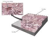
Figure 3.
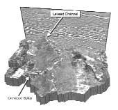
Chair display comprising two time slices and a seismic reflection profile,illustrating a deep-water highsinuosity leveed channel system;Miocene of the offshore Gulf of Mexico.The inset illustrates a voxbody interpretation of an inferred overbank splay deposit.
2003 CALENDAR OF EVENTS
DATE: April 6-10,2003
EVENT: SAGEEP 2003
LOCATION: San Antonio,Texas
INFORMATION: The Environmental and Engineering Geophysical Society (EEGS) invites you to submit a paper for presentation at the 2003 Symposium on the Application of Geophysics to Environmental and Engineering Problems (SAGEEP 2003). In addition to world-class oral and poster presentations on the application and recent developments in applied geophysics,there will be a suite of workshops,as well as an exhibition showcasing geophysical products and services. For more information on EEGS please visit our site at www.eegs.org.Please submit abstracts electonically to the SAGEEP 2003 Technical Chair,Cathy Skokan at cskokan@mozart.mines.edu
DATE: April 27,2003
EVENT: Saskatchewan Geological Society Core Workshop LOCATION: Industry and Resources Core Laboratory 201 Dewdney Avenue East,Regina,Saskatchewan
INFORMATION: Theme: Characterization of Horizontal Well Reservoirs Registration Fee: Cheques or money order only - No Credit Cards,Cdn $75 (includes Core Workshop volume) Students Cdn $30 (Core Workshop volume extra) Please Note: Payment should be made out to the Saskatchewan Geological Society,and sent to Saskatchewan Geological Society,P.O.Box 234,Regina, Saskatchewan,S4P 2Z6.For more information please call: Melinda Yurkowski:Phone:(306) 787-0650,Fax:(306) 787-4608,E-mail:MYurkowski@ir.gov.sk.ca
DATE: April 27-29,2003
EVENT: Eleventh Williston Basin Horizontal Well & Petroleum Conf. LOCATION: Delta Regina Hotel, Regina,Saskatchewan
INFORMATION: Informal talks;poster discussions; and workshops on geology, engineering,and geophysics pertaining to new developments in petroleum exploration and production within or applicable to the Williston Basin.For information call 306-787-7662 (Canada) or 701-328-8000 (US).
DATE: May 11-14,2003
EVENT: AAPG Annual Meeting LOCATION: Salt Lake City,Utah
INFORMATION: For more information please visit www.aapg.org
DATE: June 2-6,2003
EVENT: 2003 CSPG/CSEG Annual Convention - “Partners in a New Environment” LOCATION: Round Up Centre,Stampede Park,Calgary,Alberta
INFORMATION: For more information please contact Lori Humphrey-Clements Tel:403-264-5610 Email:lori@cspg.org
DATE: August 10-14,2003
EVENT: GeoSciEd IV:Earth Science for the Global Community LOCATION: Calgary,Alberta
INFORMATION: The fourth international meeting for earth science teachers from elementary to university level,and for earth scientists who deliver
educational outreach programs through their communities, museums,or science centres.The purpose is to share ideas and concepts in earth science education and in the development of programs that lead to an integrated understanding of the Earth.The innovative technical program will include keynote addresses,workshops,and oral and poster sessions.Field trips will visit many worldrenowned sites of interest including the Rocky Mountains,the Burgess Shale,the Royal Tyrrell Museum of Paleontology,the Frank Slide,and the Athabasca Glacier. Please visit www.geoscied.org for details.
DATE: September 21-24,2003
EVENT: The Society for Organic Petrology (TSOP), 20th Annual Meeting
Abstracts due 4/15/03.Oral and poster sessions September 22-23.Topics include petroleum systems, source rocks,coalbed methane,coal characterization (Ron Stanton memorial session),government,and energy.Short courses (Sept.21) on trace elements in coal and health impacts of coal plus a core workshop on coal and petroleum source rocks of the National Petroleum Reserve in Alaska.Field trip (Sept.24) on geology and energy resources of the Triassic basins of northern Virginia.
Please visit www.cspg.org to download or print the monthly version of the calendar of events.
JACK PORTERVIGNETTES OF CANADIAN PETROLEUM GEOLOGY
Continued from the March Reservoir
Listed in sequence are succinct concepts that attempt to explain the origin of the bitumen contained in the McMurray formation by previous authors cited in Bell’s text as well as other pioneer geologists not cited.The list includes those involved in the discussion following the presentation of his paper.Other published opinions that postdate his publication are also listed.
Robert Bell (1883) and Richard G.McConnell (1890) of the Geological Survey of Canada both deduced from field observations that the bitumen,hosted in the McMurray sand,is an inspissated petroleum,having been altered to its present state through surface evaporation of the more volatile hydrocarbons and oxidation of that remaining.Both believed that conventional oil escaped from breached reservoirs,contained in low-amplitude structures expressed at the subjacent Devonian unconformity,migrating upward to be trapped in the McMurray Formation.McConnell (Summary of exploration in the Athabasca
petroleum regions,Alberta for 1890;Geological Survey of Canada Annual Report,Vol.V,1890-91, p.25A) states:“The commercial value of the tarsands themselves,as exposed at the surface,is at present uncertain,but the abundance of the material and the high percentage of bitumen which it contains makes it probable that it might,in the future,be probably utilized for various purposes.It proves a flow of petroleum to the surface unequalled elsewhere in the world,but its more volatile constituents have long since disappeared,and the rocks from which it issued are probably exhausted.In their extension under cover,however,the case is different,and it is here that oil of economic value must be sought”.
Wyatt Malcolm (1913) of the Geological Survey of Canada (Memoir No.29-E,Oil and Gas Prospects of the Northwest Provinces of Canada) restates the inspissated theory held by both Bell and McConnell that:“Since the bitumen has probably been derived from petroleum by evaporation and chemical
changes,it was thought that at the same distance from their outcrop the sands would be saturated with the liquid petroleum.To test this conjecture boring operations were undertaken by the Dominion Government during the nineties”.And further:“The finding (Pelican Portage well) of the heavy bitumen in the Dakota sandstones at a point so far from their natural outcrop was acknowledged to be a disappointment,as it was hoped that petroleum of a commercial quality would be found.The failure to find a liquid petroleum at Pelican River, however,does not disprove its existence at other points.Much has,no doubt,escaped,but the hardening of the tarry substance at the points of issue may have served in places to prevent the escape of all the liquid.Its escape may also have been prevented in some places by a decrease in the porosity of the sandstone, while in other places it is very probable that anticlines occur into which petroleum may have risen and been retained”.Malcolm attempts,by his remarks,to rationalize the problem of the occurrence of the bitumen in the subsurface by
Continued on Page 22 ...
speculating that it can occur in association with conventional oil thus compounding the problem of its genesis.
L.G.Huntley (1915) postulates that the bitumen associated with the McMurray sand is a residue of conventional oil generated in the “Great Plains Geosyncline”,migrating great distances by hydraulic action.He asserts that the coextensive Lower Cretaceous Dakota sand served as a regional conduit to transport the oil to its present habitat,where it was subsequently oxidized by subaerial processes to form a residue.
Glen M.Ruby (1923) theorized that oil,which had escaped from primary reservoirs,was altered to a heavy glutinous state where it was subsequently transported by streams into the sea and deposited in sediments in which it is now found.(i.e.Placer concept).
In the discussion period following Max Ball’s presentation of his paper,three distinguished geologists,who had studied the Athabasca bituminous sand deposits,expressed their opinions in regard to the genesis of the Athabasca bituminous sand.Their concepts are as follows:
George S.Hume (1934) of the Geological Survey of Canada expressed his opinion of a near
www.cspg.org or www.cseg.ca Continued from Page 21 ...
source for the provenance of the bitumen associated with the McMurray Formation.He believed the oil was generated in Lower Cretaceous marine beds,lying south and west of the Athabasca area,having migrated into the McMurray deltaic sand reservoirs.He quotes F. H.McLearn (1918),also of the Survey,as stating that “the presence of the heavy constituents stable at low temperatures can only be explained by the minimum temperature to which they have been subjected”.(Immature oil).
Oliver B.Hopkins (1934),of Imperial Oil, remarked that:“The evidence he (Ball) presents regarding the local origin of the oil content of these sands appears to be strong,if not conclusive”.He further concludes that:“the fact that the Athabasca oil does not change materially from its outcrop to where it is buried under hundreds of feet of cover lead naturally to the conclusion that some other explanation other than the loss of its volatile constituents must be responsible for its character”.
Ted A.Link (1934),of Imperial oil,rejected Max Ball’s conclusion of an in situ genesis of oil in the McMurray formation,and stated that:“The absence of high dips does not,in my opinion, preclude the possibility of migration.” He concluded that:“The important question with
For more information,please contact: Cheryl Wright (403) 259-8544 cwc@telusplanet.net
respect to the source rock remains unanswered, and as long as such is the case,the problem considered by Mr.Ball,namely,the extent of migration,also remains undetermined”.
A paper entitled:Origin of McMurray Oil Sands, Alberta,written by J.C.(Cam) Sproule was published in the Bulletin of the American Association of Petroleum Geologists in the September,1938 issue (Vol.22,No.9).The premise of Sproule’s paper is a repudiation of Max Ball’s indigenous or in situ theory for the origin of the oil (bitumen) contained in the McMurray formation.The same explanation for its occurrence was previously advanced by Beeby Thompson of London,England,who had investigated the Athabasca bituminous sand exposures during the field season of 1930.Cam Sproule also negated the theory proposed by F. H.McLearn (1917) of the Geological Survey of Canada who asserted that the overlying marine shales of the Clearwater formation served as the source rock for the bitumen contained in the McMurray sand.Likewise,he rejected Sydney C.Ells’ unpublished “residual” theory in which he proposed that bitumen,originally contained in Paleozoic carbonates,was incorporated in detritus derived from the denundation of the exposed Paleozoic surface. Ells theorized that this bitumen was
■ On-line Abstract Submission,Viewing and Printing
■ Up to Date Technical Program Schedules and Details Pertaining to Oral,Poster and Core Presentations
■ Field Trip and Short Course Catalogues Containing Descriptions, Status and Availability of Trips or Courses
■ Detailed Exhibitor Information Including Exhibition Hall Map,Schedules, List of Exhibitors and Information for Obtaining Exhibits Space
■ Information for Sponsors and Links to Sponsor Sites
■ Registration Information Including On-line Registration Option
■ News on Special Events and Student Delegate Information
■ Key Contact and Volunteer Information
■ Helpful links and Maps for Travel,City and Venue Information Including the Round Up Centre and EUB Core Lab
■ Downloadable Documentation and Forms in Convenient PDF Format
Visit the 2003 Convention Website regularly;it is your most accurate and current source for information on the Convention.
subsequently recycled into the basal Cretaceous (McMurray) sand accompanying the initial Cretaceous transgression.
Cam Sproule also rejected George Hume’s lateral migration theory of Lower Cretaceous basinward marine shale source beds being responsible for the generation and subsequent migration of oil into the coeval McMurray deltaic sand reservoirs.
Having rejected the theories advanced by the majority of his noted colleagues,in respect to the genesis of oil (bitumen) in the McMurray Formation,Cam Sproule’s explanation was a reaffirmation of Robert Bell’s theory incorporated in his Geological Survey of Canada report,published in 1885 and entitled: Report on Part of the Basin of the Athabasca River,North-West Territory,which was based on his studies during the field season of 1882. Bell was the first geologist to address the origin of the Athabasca bituminous sand.In the abstract,accompanying his paper,Sproule succinctly states:“the theory first proposed by Bell,according to which the petroleum entered the Cretaceous rocks from the underlying Devonian formations,seems to be in close harmony with the evidence at present available. It remains to be seen whether or not Bell’s theory will survive the test of future investigation”.
The reverberations of Sproule’s final remark in his abstract have yet to be extinguished.The bituminous sand being an inspissated oil deposit,resulting from subaerial alteration,as perceived by Bell,McConnell,Malcolm and Huntley,was based on empirical criteria of known seepages.However,the bitumen encountered in the subsurface at the Pelican Portage well,introduced a perplexing problem to the inspissation theory.It was Hopkins,who, in recognizing the coextensive nature of the basal Cretaceous bituminous sand in the subsurface,concluded that it required “some other explanation” than the inspissated concept.The local or in situ origin,as proposed by Ball and supported by Hopkins,appeared plausible in view of the regional flatness of the Cretaceous beds exposed in the Athabasca River valley (Fifteen feet or less to the mile in a southwesterly direction).The question of the source rock provider for such gargantuan reserves continues to remain enigmatic.The evidence of bitumen contained in the crevices in subjacent Devonian carbonates,particularly associated with low relief structures,was the basis to support the conclusions of early Geological Survey of Canada geologists, including Sproule,that the oil was originally sourced in Devonian reservoirs.
NET-TO-GROSS RATIO
Geologists are often asked to provide maps of net-to-gross ratio,but this term can mean different things to different disciplines,often causing confusion and misunderstanding.
So what could "net-to-gross" mean? The quick answer to some is:it doesn't matter;it is net pay that matters! The more helpful answer is:“It depends.” Which net and which gross is the speaker is talking about? Is it thickness,reservoir,or pay?
To sort out the confusion,there are several terms (and combinations of terms) to understand: net,gross,thickness,pay,and reservoir Basically,‘pay’ means rock within the hydrocarbon zone,‘reservoir’ means rock capable of flowing any fluid,including water, under ideal conditions,and ‘net’ means rock that exceeds various cutoffs defined by an analyst. Put the terms together in various ways and you can get (also see accompanying figures):
1) Gross thickness.This is customarily used to refer to a lithologic or sequence stratigraphic unit and doesn't have anything to do with fluids.It simply represents all rock between the top pick and bottom pick for a unit.
2) Net thickness.This is the total interval of reservoir quality rock within the gross thickness – that is,rock that will flow fluids. To be part of the net thickness,a rock's properties must exceed some defined thresholds,called cutoffs.The criteria for the establishment of cutoffs can be a complex subject by itself.
3) Gross reservoir.This means the thickness of the unit from the highest part to the lowest part that is reservoir quality,but this obviously can include tight rock (immobile fluids) inter-bedded with reservoir quality rock.Hence gross reservoir can be a subset of gross thickness.Geologists often map this instead of gross thickness,in which case it substitutes for gross thickness.
4) Net reservoir.This is the total thickness of reservoir quality rock within the gross reservoir,and is therefore identical to the net thickness defined above.It is the sum of the thicknesses of the individual reservoir quality beds within the gross unit.(Imagine distilling off the non-reservoir rock and leaving behind only the good stuff.) Although this is a more descriptive term than net thickness,it is not as widely used.
5) Gross pay.This is the thickness of rock from the highest point of hydrocarbon saturation (usually the base of the top seal of
NED ETRIS, Ph. D., P. Geol., BRUCE STEWART, M. Eng.
the reservoir) to the lowest point,which is not necessarily the base of the reservoir (if a hydrocarbon-water contact is present).As with gross reservoir,though,this interval may include non-reservoir and,therefore,low or no hydrocarbon-saturation rock,but it is often smaller than gross reservoir because of the presence of water.(We ignore capillary pressure and transition zone effects in this article because they are a complication unnecessary for the general understanding of the terms of interest.)
6) Net pay.This is the total thickness of reservoir quality rock that will flow some amount of hydrocarbons from rock exceeding user-determined cutoffs.It is the sum of the thicknesses of the individual reservoir quality beds within the gross pay unit.(Again,imagine distilling off the nonreservoir rock and leaving behind only the good stuff,but in this case not including rock containing substantial amounts of water.)
So,what does a person mean when he says, "net-to-gross ratio?" Guess what? You can't tell without checking the gist of the conversation, or the mapping if it is provided,because the ratio could refer to thickness or to pay! One supposes to be more informative we should say “net-to-gross thickness” and “net-to-gross pay,” but these terms are not widely used.
In our experience,the most common usage of net-to-gross ratio among flow-simulation engineers refers to net-thickness-to-grossthickness,because its main use in reservoir flow simulators is to determine the volume of rock holding a mobile fluid,whether gas, oil,or water.(Flow simulators don't even know about the non-flowing rock that may be part of gross thickness;they ignore it.But flow simulators care about flowing water as much as about flowing hydrocarbons,because it provides critically important pressure support.) The actual volume of hydrocarbon is then determined by taking into account the hydrocarbon-water contact.
By contrast,within the context of reserves calculations,net-to-gross ratio is usually the ratio of net pay to one of the gross parameters,because its main purpose is to determine the hydrocarbons in place. Confusion arises in this case because there is no standard for whether the gross parameter is gross thickness,gross reservoir,or gross pay.It is easy to see how,without a clear definition of the terms of reference or maps clearly defining what volume of rock is in the calculations,the net-to-gross ratio of one individual may be misapplied by a second.
The terms in the third set – net and gross reservoir – are subtle variations of the
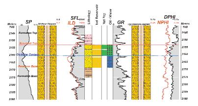
Example 1:A real data example
In this example of actual wireline data from western Canada,we illustrate which portions of the formation are Net Reservoir and which portions are Net Pay.
The Formation Top and Formation Base in this case are regional chronostratigraphic surfaces,and do not correspond to the top and the base of sands or of reservoir quality rock.Between them is the Gross Thickness interval.The Gross Reservoir interval is between the Reservoir Top and Reservoir Base,and includes water as well as oil zones,and impermeable shales (brown,dashed Lithology zone) as well as
permeable sands (yellow,stippled Lithology zone), trapped below an anhydrite layer (pink Lithology zone at top).
An analyst has applied some cutoffs to break the gross interval into three separate Net Reservoir intervals (colored orange) by removing the shale breaks,but ignoring the fluids.These three intervals are further reduced to two Net Pay intervals (colored green) by removing the water-bearing zone (colored blue with wavy lines).
previous terms and are more commonly used by geologists in describing the vertical limits of the permeable reservoir rock,irrespective of fluids.
Perhaps a larger point to keep in mind is that net-to-gross ratio by itself is not even interesting;it is just a conveyance to get to net reservoir,or to net pay in the context of reserve determinations.As long as you are consistent in your meaning of net and gross then your net-to-gross ratio will work.In other words,you'd better be able to backcalculate your gross value using only your net value and your net-to-gross ratio,or you are most likely mixing net and gross definitions.
When it comes to calculating volume of hydrocarbons – a calculation necessary for reserves certification – it is only net pay that matters.Perhaps someone would use net-togross pay to calculate net pay as an intermediate step,but there is little intrinsic value in the net-to-gross ratio itself.It is net pay – along with area,porosity,water saturation,*formation volume factor,and recovery factor – that determines volume of hydrocarbons in place and technically recoverable hydrocarbons for economic determinations.
* formation volume factor:the change in volume of the hydrocarbon between reservoir conditions and surface conditions.
The authors welcome your comments:
netris@corelab.ca
Edward (Ned) Etris received M.Sc.(1987) and Ph.D.(1991) degrees in geology from the University of South Carolina.An experienced reservoir characterization geologist and numerical reservoir model developer,Ned has worked in oil companies and consulting firms progressing from research to development drilling and field exploitation,with experience ranging from regional prospecting to detailed reservoir characterization. Currently Manager of Geologic Services at Core Lab,he directs work on geological studies,timedepth conversion,3D geological modeling,and petrophysical studies,and plays a key role in integrated geophysical-geological-engineering studies within the Reservoir Modeling Group.
bstewart@corelab.ca
Bruce Stewart completed his M.Eng.(1984) Degree from the University of Calgary,and has worked for several oil companies in Calgary and overseas.His area of expertise is reservoir characterization and reservoir modeling within
the framework of integrated teams of geophysicists,geologists,petrophysicists and reservoir simulation engineers.Bruce currently works for Core Laboratories in Calgary as a Staff Simulation Engineer.
The authors would like to thank Mauro Cimolai for his helpful comments.
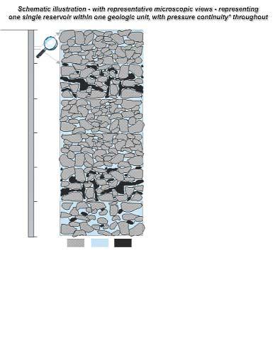
low porosity, low permeability, very low or no oil saturation, non-reservoir (upper seal)
high porosity, high permeability, high oil saturation, gross and net reservoir
low porosity, low permeability, very low or no oil saturation, gross reservoir
low porosity, low permeability, very low or no oil saturation, gross reservoir
high porosity, high permeability, high oil saturation, gross and net reservoir
high porosity, high permeability, high water saturation, gross and net reservoir
RockWaterOil
Gross thickness = A+B+C+D+E+F = 6 m
Gross reservoir = B+C+D+E+F = 5 m
Gross pay = B+C+D+E = 4 m
Net thickness = Net reservoir = B+E+F = 3 m
Net pay = B+E = 2 m
*pressure continuity implies connectivity in 3D.
Note that this simplified example does not consider cut-offs, transition zones, or bed thickness minima.
Example 2:Net-to-gross calculations
i. Using Gross Thickness: If the volume being mapped is between top A and base F,then net-togross for simulation is (net thickness /gross thickness) = 3/6 = 50%,whereas net-to-gross for reserves is (net pay/gross thickness) = 2/6 = 33.3%.
ii. Using Gross Reservoir: If the volume being mapped is between top B and base F,then net-togross for simulation is 3/5 = 60%,whereas net-togross for reserves is 2/5 = 40%.
iii. Using Gross Pay: If the volume being mapped is between top B and base E,then net-to-gross for simulation would be an untenable calculation (because top B to base E leaves out a part of the model critical to flow simulation:the pressure
support provided by water-saturated interval F).Netto-gross for reserves for this interval is 2/4 = 50%.
The bottom line: It is net pay and net thickness that matter;net-to-gross ratios are just a way to get to net values.In this example,the net-to-gross ratio for reserves is variously 33.3%,40%,or 50%, depending on the volume being mapped,but the net pay is always 2m.
In general,regardless of what kind of net-to-gross ratio is used,whether it's net-thickness-to-gross-thickness for flow simulations or net-pay-to-gross-pay for reserves calculations:1) keep your definitions straight, and 2) the net pay and net reservoir thickness are not necessarily equal.
GNEISS N’ LITE - HUMOR FOR THE GEOLOGIST
The following is a compilation of ‘Did you hear about…’ that has been accumulating in Gneiss and Lite columns over the past few years.So,here goes:
Did you hear about the:
• the clastic geologist who was ‘well-rounded’.
• the carbonate geologist from Englandhis friends called him ‘limey’.
• the development geologist who was a reservoir of knowledge.
• the foothills geologist whose life was very structured.
• the structural geologist who adamantly stated:‘This is not my fault!’
• the economic geologist who demanded higher remuneration…and he got it!
• the ichnologist whose favorite song was ‘Happy Trails To You’.
• the hydrogeologist who got so immersed in his work that he was buoyed by the experience.
• the geotechnical person who felt he just had too dam much work to do!
• the clay mineralogist who thought his job was just swell.
• the petrophysicist who was into transcendental meditation – his mantra was ‘ohm’.
• the paleontologist who was so old that he became his own fossil.
• the petrographer whose work was always under microscope.
• the sedimentologist whose favorite song was ‘Sedimental Journey’.
• the stratigrapher who knew all about flatlying beds.
• the glacial geologist who was a bit of an erratic.
• the vulcanologist who was a tuff guy and was always venting his anger – and no,he was not from Vulcan,Alberta,and was not related to Spock.
• the gemologist who liked carats in his salad.
• the gemologist who thought his job was facet-nating.
• the lapidary who was gritty,even though his friends never saw through his
polished appearance.
BY BOB ROBSON
• the ichnologist who was so old fashioned he was still using ‘snail-mail’.
• the igneous petrologist who had a very intrusive nature.
• the geothermal engineer who was controversial and then found out he could not take the heat.
• the geochemist who was always reacting violently.
• the geophysicist who compared life’s ups and downs to troughs and peaks.
• the optical mineralogist who could see right through people.
All of the above are like farmers - they are people who are outstanding in their fields!
So,which of the above categories describes you? If you have anything to add to the subject,just write it down as forward it to: bob.robson@shaw.ca and until next time,as Red Green would say:‘Keep your stick on the ice’.
Continued from Page 19 ...
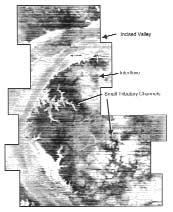
Figure 4.
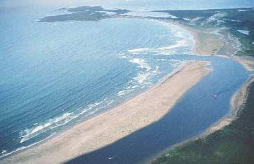
Incised fluvial system of Pleistocene age,offshore northwest Java.Note the presence of channel bars and tributary incised drainage systems.
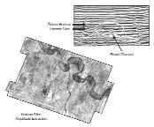
Figure 5.
Horizon slice of a high-sinuosity fluvial channel crosscut by a lower sinuosity channel;Miocene of offshore northwest Java.
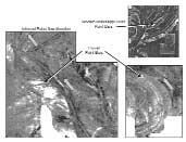
Figure 6.
Fluvial channels with point bars and scroll bars, Alberta.Inset shows similar features on the modern Mississippi floodplain.Paleo-flow direction is inferred on the basis of truncation of scroll bars on their upstream side.
magnitude (Fig.1E),curvature (Fig.1F), structure (Fig.1G),and roughness.Each attribute can bring to light different characteristics of the feature of interest,each characteristic aiding in the interpretation of the feature and ultimately the prediction of lithologies in the associated section.Simply imaging a surface in three dimensions and then lighting it from various directions also can aid in interpretation and afford significantly different insights (Figs.1G and 2).
INTERVAL ATTRIBUTES
In some instances,interval attribute extractions are the tool of choice.This is especially true where features are subtle and discrete seismic reflections are difficult to interpret and map. This approach involves the seismic analysis of stratigraphic intervals that bracket features of interest;analyses include characterization of amplitude,frequency,and seismic waveforms.
VOXBODY DETECTION
Features of interest can also be imaged by detecting,mapping,and visualizing voxels (i.e.,three-dimensional pixels) in 3D views.In this approach,voxels are highlighted according to amplitude range and then tracked in three dimensions (Fig.3).The amplitude range can be selected to correspond to a specific lithology,the presence of hydrocarbons,or simply a specific seismic reflection.Identification of depositional elements,fluid contacts,and interpretation of seismic reflections can be facilitated through this approach.
OPACITY RENDERING / SUBVOLUME DETECTION
3D seismic volumes can be rendered transparent or partially transparent according to the interpreter’s display criteria.In this way, the interpreter can “see through” the seismic volume and concentrate on features of interest that can be imaged within a certain amplitude range,which the interpreter has rendered opaque.The interpreter can quickly target features of interest for follow-up analyses.
DISCUSSION
Features imaged in map view can be analyzed using basic principles of geomorphology. These map representations comprise a view of the landscape as it existed in the distant past with one minor caveat.That is,what is seismically imaged actually represents that part of the landscape that has been preserved subsequent to post-depositional erosion.For example,fluvial channels are dynamic in nature and because of repeated reactivation and potential erosion,any present-day landscape is subject to later modification. What is observed on seismic data is the end
Figure 7.
Integrated interpretation of alternate bars in a low sinuosity fluvial / distributary channel.Note the presence of lateral accretion surfaces imaged on the seismic reflection profile.Well logs indicate the presence of blocky to fining upward sandstone pattern.
8.
Perspective view of a Pleistocene leveed channel system,offshore Gulf of Mexico.Note the positive relief that characterizes the channel thalweg,indicating the presence of relatively uncompactable sandstone. Note also the presence of an avulsion channel in the lower part of the image.This channel could be feeding a crevasse splay just outboard of the imaged area.
9.
Perspective
with associated
Continued on Page 30 ...
Figure
Figure
view
seismic section,of a Pliocene leveed channel and crevasse splay,offshore Gulf of Mexico.
product of this dynamic process.Figures 1,2, 4,5,6,and 7 illustrate a variety of fluvial systems.Details such as channel bars,scroll bars,and tributary incised channels can be observed and interpreted with regard to reservoir architecture and quality.Detailed examination of scroll bars can indicate direction of paleo-flow direction.
Seismic geomorphological analyses require specific skill sets.It is critical for interpreters to be able to recognize geologically significant map patterns.They must be able to distinguish seismic noise from seismically imaged depositional elements.In order to do that,the interpreter must be familiar with the geomorphology of as broad a range of depositional elements as possible.Of course, the interpreter must also be familiar with various expressions of seismic noise (whether associated with data acquisition or data processing issues).
Once features of interest are identified in map view,it is essential to examine these features in cross section to get stratigraphic confirmation of depositional origin if possible.3D seismic data make possible any orientation of cross section desired,which can be used to evaluate the stratigraphic architecture and rule out the possibility that the feature in question is not structurally related,nor is it a data artifact.Figure 7 illustrates a meandering fluvial channel with possible scroll bars.A transverse seismic section exhibits associated lateral accretion surfaces and therefore confirms the interpretation of a fluvial system with point bar development. Further confirmation of this interpretation comes from borehole information,where well logs exhibit a blocky to fining-upward trend,typical of point bar deposits.
Interpretation of depositional elements also benefits from imaging surfaces in three dimensions.Figures 8 and 9 illustrate Pleistocene leveed channels with associated depositional elements.Perspective views enhance these features thereby facilitating their interpretation.
CONCLUSIONS
Seismic geomorphology is an essential complement to seismic stratigraphy and involves the analysis of paleo-landforms.The key to success of this approach involves thorough integration of seismic geomorphology and seismic stratigraphy,and subsequent calibration by borehole data. Knowledge of map view expression of a range of depositional elements is essential for this approach.From an exploration perspective,the identification of depositional elements,with
their typical lithologic and stratigraphic expressions,can significantly aid in the prediction of reservoir,source,and seal facies.In addition,this approach can offer fresh insights to potential reservoir compartmentalization and improved petroleum exploitation. This approach has been made possible through the widespread availability of 3D seismic data,the rapid advances in computer hardware capable of manipulating huge volumes of data,and the development of software applications such as Stratimagic, VoxelGeo,and Geoprobe,which facilitate volume-based analyses of the subsurface.
ACKNOWLEDGEMENTS
I would like to thank Anadarko Canada Corporation for permission to publish this paper.I also acknowledge the support of our information technology team,including Dave Matthews,Tom Lemon,Barry Wiseman,and Ken Hryciew,as well as our team technologist,Randy Evans.They all provided me with unparalleled support and endless patience with my never-ending technical issues.Thanks also to Paradigm Geophysical,including Paul Leper and Azer Mustaqueem,for their software support and guidance.