

20 Fossils Hunting for Provinces 28 Go Take a Hike 34 GeoConvention 2014: Focus 36 Bringing the Cretaceous Sea to Mount Royal University: A Proposal to Fund the East Gate Entrance Fossil Display $10.00 MAY 2014 VOLUME 41, ISSUE 05 Canadian Publication Mail Contract – 40070050

WANT TO LIFT YOUR PETREL WORKFLOWS TO NEW HEIGHTS?
Seamlessly bring more data into the fold. Dynamically present your insight like never before.
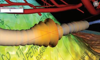
The Petrosys Plug-in for Petrel ® gives you access to powerful Petrosys mapping, surface modeling and data exchange from right where you need it – inside Petrel. Now you have the power to effortlessly and meticulously bring your critical knowledge together on one potent mapping canvas. Work intuitively with your Petrel knowledge and, should you so require, simultaneously aggregate, map and model data direct from multiple other sources – OpenWorks ®, ArcSDE®, IHS ™ Kingdom ®, PPDM ™ and more. Refine, enhance and then present your results in beautiful, compelling detail. The result? Decision-making is accelerated through consistent mapping and surface modeling as focus moves from regional overview through to the field and reservoir scale. To learn more go to www.petrosys.com.au/petrel
SOFTWARE SERVICES CONNECTIVITY DATA MANAGEMENT
Petrel
registered trademark of Schlumberger Limited and/or its affiliates. OpenWorks is a registered trademark of Halliburton. ESRI trademarks provided under license from ESRI. IHS and Kingdom are trademarks or registered trademarks of IHS, Inc. PPDM is a trademark of the Professional Petroleum Data Management (PPDM) Association.
is a
CSPG OFFICE
#110, 333 – 5th Avenue SW
Calgary, Alberta, Canada T2P 3B6
Tel: 403-264-5610
Web: www.cspg.org
Office hours: Monday to Friday, 8:30am to 4:00pm
Executive Director: Lis Bjeld
Tel: 403-513-1235, Email: lis.bjeld@cspg.org
Event Coordinator: Kristy Casebeer
Tel: 403-513-1226, Email: kristy.casebeer@cspg.org
Member Services:
Tel: 403-264-5610, Email: membership@cspg.org
Publications and Website: Emma MacPherson
Email: emma.macpherson@cspg.org, Tel: 403-513-1230
Educational Trust Fund/Outreach Coordinator: Kasandra Amaro
Tel: 403-513-1226, Email: kasandra.amaro@cspg.org
Technical Programs: Biljana Popovic
Tel: 403-513-1225, Email: biljana.popovic@cspg.org
Corporate Sponsorship: Lis Bjeld
Tel: 403-513-1235, Email: lis.bjeld@cspg.org
Controller: Eric Tang
Tel: 403-513-1232, Email: eric.tang@cspg.org
EDITORS/AUTHORS
Please submit RESERVOIR articles to the CSPG office. Submission deadline is the 23rd day of the month, two months prior to issue date. (e.g., January 23 for the March issue).
To publish an article, the CSPG requires digital copies of the document. Text should be in Microsoft Word format and illustrations should be in TIFF format at 300 dpi., at final size. For additional information on manuscript preparation, refer to the Guidelines for Authors published in the CSPG Bulletin or contact the editor.
Technical Editors
Hugh S. Mosher Colin Yeo (Assistant Tech. Editor) Nunaga Resources Ltd. Encana Corporation
M.: 403-809-9997 Tel: 403-645-7724
Email: hsmosher@telus.net Email: colin.yeo@encana.com
Coordinating Editor
Emma MacPherson, Publications Coordinator, CSPG Tel: 403-513-1230, emma.macpherson@cspg.org,
ADVERTISING
Advertising inquiries should be directed to Emma MacPherson, Tel: 403-513-1230 email: emma.macpherson@cspg.org. The deadline to reserve advertising space is the 23rd day of the month, two months prior to issue date.
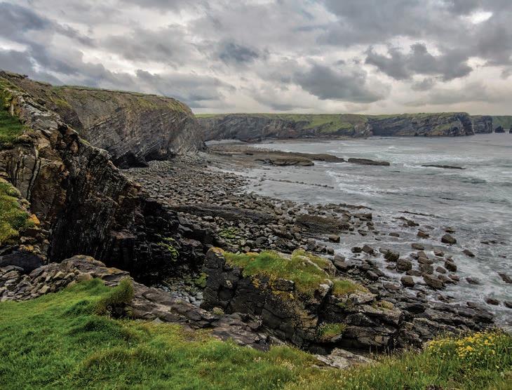
RESERVOIR ISSUE 05 • MAY 2014 3 MAY 2014 – VOLUME 41, ISSUE 05 ARTICLES Fossils Hunting for Provinces ..................................................................................................... 20 Tools to Tackle the Riddle of the Sands 27 Go Take A Hike 28 2013 Stanley Slipper Gold Medal ............................................................................................... 31 2013 H.M. Hunter Award 32 2013 Tracks Award ....................................................................................................................... 33 GeoConvention 2014: Focus 34 2014 Canadian Playmaker Forum ............................................................................................. 35 Bringing the Cretaceous Sea to Mount Royal University: A Proposal to Fund the East Gate Entrance Fossil Display 36 DEPARTMENTS Executive Comment .................................................................................................................. 5 Technical Luncheons 8 Division Talks ........................................................................................................................... 12 Rock Shop 11, 12, 15, 25, 34 FRONT COVER Carboniferous Distal Fan deposits of the Ross Formation at Ballybunnion, County Kerry, Ireland. Broad wave cut platforms exposed at low tide are backed by steep, unstable cliffs that reveal the transition between the Ross Sandstone Formation and the underlying Clare Shales. Photo by Dave Hills.
The RESERVOIR
published
times per year
Canadian
Petroleum
This includes a
issue
purpose of the RESERVOIR is to publicize the Society’s many activities and to promote the geosciences. We look for both technical and non-technical material to publish. Additional information on the RESERVOIR’s submission guidelines can be found at http://www.cspg. org/publications/pubs-reservoir-submissions.cfm. The contents of this publication may not be reproduced either in part or in full without the consent of the publisher. Additional copies of the RESERVOIR are available at the CSPG office. No official endorsement or sponsorship by the CSPG is implied for any advertisement, insert, or article that appears in the Reservoir unless otherwise noted. All submitted materials are reviewed by the editor. We reserve the right to edit all submissions, including letters to the Editor. Submissions must include your name, address, and membership number (if applicable). The material contained in this publication is intended for informational use only. While reasonable care has been taken, authors and the CSPG make no guarantees that any of the equations, schematics, or devices discussed will perform as expected or that they will give the desired results. Some information contained herein may be inaccurate or may vary from standard measurements. The CSPG expressly disclaims any and all liability for the acts, omissions, or conduct of any third-party user of information contained in this publication. Under no circumstances shall the CSPG and its officers, directors, employees, and agents be liable for any injury, loss, damage, or expense arising in any manner whatsoever from the acts, omissions, or conduct of any third-party user. Designed and Printed by The Data Group of Companies, Calgary, Alberta.
is
11
by the
Society of
Geologists.
combined
for the months of July and August. The
PETROLEUM INDUSTRY COURSES
Old Geologists never die, they just simply petrify!
by: Bill Ayrton
WHO SHOULD ATTEND
New geologists, engineers, geophysicists and landmen, as well as summer students entering the industr y for the first time will find the courses a very beneficial introduction to the petroleu m industry These courses will be extremely useful to nonprofessional and support staff in the oil and gas industry, as w ell as accountants, lawyers, brokerage and financial personnel working primarily alongside the oil and gas industry.
TO REGISTER
To register or to obtain additional information regarding in-house and upcoming courses, please contact:
Ayrton Exploration Consulting Ltd.
Tel: (403) 262-5440
Email: ayrtonex@shaw.c a
Or visit our website: www.ayrtonexploration.com
OVERVIEW OF THE OIL & GAS INDUSTRY IN WESTERN CANADA
Date: April 30th and May 1st, 2014
Cost: $1050 (includes GST)
Instructor: Bill Ayrton
Effective for personnel just joining the oil patch, or for financial, accounting, and information systems personnel.
• Learn about the many facets of the industry.
• Oil finding, land acquisition, drilling, seismic, well completion, jargon and terminology.
GEOLOGY FOR NON-GEOLOGISTS
Date: June 4th and 5th, 2014
Cost: $1050 (includes GST)
Instructor: Bill Ayrton
Effective for geological technicians or administrative staff, or for those who just want a better understanding of geology to appreciate the world around us.
• Learn about earth structure, geologic time-scale and processes, Western Canada geology, and interesting nearby locations.
• Participate in a r ock identification exercise , cross-section project and a mini-field trip in downtown Calgary.
GEOLOGY OF THE WESTERN CANADIAN SEDIMENTARY BASIN
Date: June 10th, 11th, and 12th, 2014
Cost: $1575 (includes GST)
Instructor: Bill Ayrton
Ideal for those who wish to improve their geological understanding of where and how we look for oil and gas fields in Western Canada.
• To visualize what Western Canada looked like throughout the stages of history, for example, the position of the sea versus land, what sediments were deposited, and what type of life that existed and evolved.
• To review the importance of each major stratigraphic unit, i.e. Devonian, Mississippian, Cretaceous, etc.
• Discuss the geological and seismic expression of typical oil and gas fields in each unit.
• To review the variety of “unconventional” oil & gas plays currently being pursued.
technology • seismic • rocks • maps • formations • land • sediments • history • sea • fossils • environment
Photo
GE OLOG Y FO R NON- GE OLOG ISTS Pr esen ted by W.G. Bi ll) A yr to


CSPG EXECUTIVE
PAST PRESIDENT
Paul MacKay • Shale Petroleum Ltd. paul.mackay@shalepetroleum.com Tel: 403.457.3930
PRESIDENT Dale Leckie
PRESIDENT ELECT
Tony Cadrin • Journey Energy Inc. tony.cadrin@journeyenergy.ca Tel: 403.303.3493
FINANCE DIRECTOR
Gord Stabb • Durando Resources Corp. gstabb@durando.ca Tel: 403.819.8778
FINANCE DIRECTOR ELECT
Astrid Arts • Cenovus Energy aarts@barrick-energy.com Tel: 403.766.5862
DIRECTOR
Alexis Anastas • Nexen Energy ULC alexis_anastas@nexencnoocltd.com Tel: 403.699.4965
DIRECTOR
Andrew Fox • MEG Energy Corp. andrew.fox@megenergy.com Tel: 403.770.5345
DIRECTOR
Milovan Fustic • Statoil Canada Ltd. MFUS@statoil.com Tel: 403.724.3307
DIRECTOR
Michael Laberge • Channel Energy Inc. mike.laberge@telus.net Tel: 403.301.3739
DIRECTOR
Robert Mummery • Almandine Resources Inc. mummery1@telus.net Tel: 403.651.4917
DIRECTOR
Weishan Ren • Statoil Canada Ltd. wren@statoil.com Tel: 403.724.0325
DIRECTOR
Darren Roblin • Endurance Energy snowice@telus.net Tel: 587.233.0784
EXECUTIVE DIRECTOR
Lis Bjeld • CSPG lis.bjeld@cspg.org Tel: 403.513.1235
EXECUTIVE COMMENT
A message from 2014 President Elect, Tony Cadrin
Welcome to GeoConvention 2014
FOCUS: ADAPT, REFINE, SUSTAIN. As stated on the GeoConvention website; “Focus 2014 will showcase the necessary sharpening of tools, techniques, and images required to find and produce oil and gas efficiently. Against a backdrop of changing macro and micro conditions, the industry must adapt by focusing attention on the most significant facets of an operation, refining evolving workflows, and sustaining effective practices.”
GeoConvention will host three days, May 12-14, of technical programs comprised of both oral and poster sessions. Over 100 exhibiting companies on the exhibition floor from May 12-14th enable the delegates to view new technologies, explore new business opportunities, and learn from industry experts. We are expecting over 4000 attendees over the duration of the Convention. There is also a 2-day core conference hosted at the AER Core Research Centre on May 15-16th. The Core Conference is concluded by the famous AGAT sponsored Core Meltdown hosted at the University of Calgary.
There are a large number of events being hosted at GeoConvention this year including 2 Keynote luncheons, the Monday night social event hosted in the exhibit hall for all delegates to join colleagues, friends and potential clients for food, drinks and conversation, and the CSPG Awards and Volunteer recognition presentations hosted at the Hyatt Regency followed by a reception. All CSPG members, spouses and friends are welcome.
On Tuesday night there is second social event in the exhibit hall and the CSPG Long Time Members reception will be hosted at the Palliser hotel for those who have been a CSPG member for 30+ consecutive years. At this event you will be able to eat, drink, mingle and watch the presentation of the 2013 Honorary Membership awards.
Wednesday is a fun packed day starting with the Industry-Student luncheon held in the Imperial Ballroom of the Hyatt Regency Hotel where you can mingle with university students from across the country who is attending the CSPG University Outreach sponsored Student Industry Field Trip.
The 2014 GeoConvention is pleased to announce its’ inaugural Alumni Reception Event. This invite only event is intended for Alumni from Memorial University, University of New Brunswick Fredericton, St. Francis Xavier University, Dalhousie University, Saint Mary’s University, and Acadia University. This event is meant to bring together University alumni who are but not excluded to CSEG, CSPG, and CWLS members along with representatives of the Geoscience Departments from their respective Universities. Don’t miss this opportunity to get re-acquainted with the Professors and acquainted with their PhD and MSc students to share your mutual interest in research topics relating to their fields of study.
This years’ Challenge Bowl, sponsored by GeoConvention, will host an action-packed geoscience quiz game for geological and geophysical student members. Teams from across Canada complete for the grand prize – an expenses paid trip to the SEG convention to represent Canada while competing against other SEG chapters from around the world. This marquee event will be held at MacLeod Hall A, South Building, Calgary TELUS convention center. After the Challenge Bowl concludes, the CSPG University Outreach committee will be hosting a pub night for the participants and the University and Industry audiences. The International Division is hosting a Networking Event at the Libertine from 4:30-7:00pm to thank all their members, sponsors and
(Continued on page 7...)
RESERVOIR ISSUE 05 • MAY 2014 5
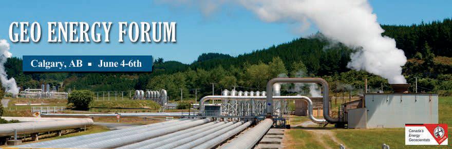
June
4 June 4--6th, 2014 |
Nexen Theatre 6th, 2014 | Nexen Theatre
Hot Reservoirs: The ultimate goal is to discover synergies between experienced industry in geothermal energy production and hydrocarbon industry with expertise in Alberta foreland geology, to spur economic opportunities for renewable energy development in Alberta.
Stressed Reservoirs: The goal of the forum is to have dynamic discussion about how knowledge of the stress state in subsurface reservoirs can help foster responsible development and optimize production.
Hot Reservoirs Speakers Announced!
Stephan Uhlig GeotecConsult, Germany
Geothermal success stories in foreland basins
Innovative geothermal technologies and perspectives
Warren Walsh
Ministry of Energy and Mines, British Columbia
Gerhard Pernecker Municipality Altheim, Austria
Stephan Hild Exorka GmbH, Germany
Jonathan Banks University of Alberta
Inga Moeck
Geothermal potential and synergies with hydrocarbons
University of Alberta & Technical University Munich
Craig Dunn Borealis Geopower Canada
Steve Grasby
Canadian Geological Survey
Grant Fergusson University of Saskatchewan
Kirk Osadetz
Canadian Geological Survey
Tibor Lenglin University of Alberta
Member Non Member Speaker Student Geo Energy Forum (3 Days) $295.00 $320.00 $270.00 $195.00 Geothermal Forum (2 Days) $225.00 $250.00 $200.00 $150.00 Stress Forum (1 Day) $150.00 $175.00 $125.00 $110.00 Register today at www.cspg.org/conferences
CORPORATE SPONSORS
SAMARIUM
geoLOGIC systems ltd.
TITANIUM
Nexen ULC
APEGA
ConocoPhillips
IHS
Shell Canada Limited
PLATINUM
Schlumberger Canada Limited
Cenovus Energy Inc.
Imperial Oil Resources
AGAT Laboratories
Statoil Canada Ltd.
GOLD
Baker Hughes
Devon Canada Corporation
MEG Energy Corp.
Tourmaline
Canadian Natural Resources Ltd.
SILVER
MJ Systems
CGG Services (Canada) Inc.
Suncor Energy
Encana Corporation
Athabasca Oil Corporation
Enerplus
Husky
ION Geophysical
Paramount Resources
Petrosy
BRONZE
Olympic Seismic Ltd.
Roke Technologies Ltd.
Seisware
Sensor Geophysical Ltd.
Arcis Seismic Solutions
Loring Tarcore
PGS
Saudi Aramco
Tucker Energy Services Canada Inc
Pro Geo Consultants
Belloy Petroleum Consulting
Hunt Oil
Talisman
Tesla
TGS
Continental Laboratories (1985) Ltd.
Earth Signal Processing Ltd.
Explor
GLJ Petroleum Consultants Ltd.
Paradigm Geophysical (Canada) Corp.
PLS Inc.
As of April 2014
A Special Thanks to Geologic Systems Ltd.,
CSPG ’s Top Sponsor of the Month.
(...Continued from page 5)
presenters for an outstanding year of technical excellence.
There are seven continuing education courses offered from late April to early June, 2014 (please check the CSPG or GeoConvention Focus 2014 websites for details) and 2 Field seminars. The first seminar titled “Turner Valley’s Centennial, A field trip through changing interpretations and unchanging rocks” will be run on May 11th by Paul MacKay and Clinton Tippett and the second titled “SAGD Fundamentals, field seminar in Ft McMurray, AB will be run on June 17-18th by Rudy Strobl, Milovan Fustic, and Daryl Wightman.
May is the month of GeoConvention. This is our showcase event and one of the primary methods we have of meeting our mandate and also funding the ongoing work of the Society and Educational Trust Fund. The Canadian Society of Petroleum Geologists’ mandate is to disseminate technical knowledge in geology, particularly pertaining to petroleum geology, to the broader Canadian community. We are dependent on the success of the convention on many levels. A successful convention means we have the financial strength to carry on the Society’s activities for the remainder of the year and therefore gives stability to the society. The Convention is a multi-million dollar event that is dependent on volunteers and staff for direction, organization, and evaluation. To further this end, we decided to bring structural stability to the Convention by forming a Limited Partnership with the CSEG and CWLS. This structure is called GeoConvention. GeoConvention will have its own board of Director’s, staff, and office. CSPG is amply represented on the board by 3 CSPG, 3 CSEG and 1 CWLS volunteers who will represent the interests of the societies. The goal is that revenue will improve from the Convention by increased attendance, better consistency from year-to-year, greater demand on the Exhibit Floor, and an effective long-term marketing strategy.
This will be the last convention operated by the CSPG on behalf of the three societies (Canadian Society of Exploration Engineers, Canadian Society of Petroleum Geologists, and Canadian Well Logging Society). The responsibility of planning and operating the annual convention will now fall to the newly formed Limited Partnership (CSEG, CSPG, CWLS) which will be stewarded by the GeoConvention board and it’s staff. The current representation on this board is Robert McGrory (Chair, CSEG), Tony Cadrin (CSPG), David Clyde (CSPG), Samantha Etherington (CSPG), Robert Kendall (CSEG), Robert Vestrum (CSEG), and Nabil Al-Adani (CWLS). The board has initiated an executive search for a Convention Director to manage and operate GeoConvention on an ongoing basis, procure office space for the Director and staff, sign commitment letters for the Telus Convention Centre for 2015 and 2016, and have recruited a slate of General Chairs, representing each of the sister societies, for the 2015 GeoConvention and ongoing work to identify and recruit General Chairs for 2016 and 2017.
As you can see, the CSPG volunteer members, Executive Directors and office staff have been hard at work to provide quality technical content and opportunities to meet your industry colleagues to advance your careers in the petroleum industry. Have a happy spring and great GeoConvention experience.
RESERVOIR ISSUE 05 • MAY 2014 7
TECHNICAL LUNCHEONS MAY LUNCHEON
Celebrating the Centennial of the Discovery of the Turner Valley Field, Southwestern Alberta
AUTHORS
Clinton Tippett (Shell Canada) and David Finch (Author and Historian)
11:30 am, Wednesday, May 21, 2014 Calgary, TELUS Convention Centre Macleod Hall C/D, Calgary, Alberta
Please note: The cut-off date for ticket sales is 1:00 pm, three business days before event. [Friday, May 16, 2014]. CSPG Member Ticket Price: $45.00 + GST. Non-Member Ticket Price: $47.50 + GST.
Each CSPG Technical Luncheon is 1 APEGA PDH
Webcasts sponsored by

credit. Tickets may be purchased online at https:// www.cspg.org/eSeries/source/Events/index.cfm.
ABSTRACT
May 14, 2014 marks the 100th anniversary of the initial petroleum discovery at Turner Valley. The field sits at the leading edge of the Foothills Belt of the Rocky Mountains, just to the southwest of Calgary, Alberta. The relatively simple structure of the field features a massive thrust sheet carrying Mississippian carbonates at its base and the full Mesozoic section above them. The related surface anticline in Late Cretaceous strata, forming the crest of the Triangle Zone at this latitude, is related to the cut-out of the carbonates above the sole fault. This understanding of the subsurface was incomplete during much of the life of the field and multiple theories for its geometry have been proposed over the last century. It was only once modern seismic techniques were brought to bear to complement the extensive drilling record that the true nature of the structure became apparent. The nature and variability of the Mississippian reservoir also hold important lessons for other carbonate fields.
Early exploration was triggered by surface seeps of natural gas combined with an understanding of the anticlinal theory of hydrocarbon accumulation. Drilling at the discovery well, Calgary Petroleum Products No. 1, started in January 1913 and the well finally came in on May 14, 1914. It flowed 4 mmcf/d of wet natural gas from a depth of 828m in the sandstones of the Lower Cretaceous section. Delineation in this part of the section was slow and hampered by WWI.
On October 14, 1924 Royalite No. 4, drilled by a subsidiary of Imperial Oil that had taken over CPP’s operations, deepened a northern stepout well into the underlying Paleozoic section in the up dip part of thrust sheet and intersected the natural gas accumulation hosted in these Mississippian strata. The well blew out and is estimated to have flowed at over 20 mmcf/d with 500-600 bbl/d of condensate. This pool is now recognized as having had 1.5 TCF OGIP. Its pursuit occupied the industry from 1924 through to 1936. Exploitation primarily involved production of the natural gas for its condensate and NGL contents. Sales of the residual gas were made when possible but significant volumes were often flared when production exceeded demand. This wasteful practice reached its peak in 1931 when more than 400 mmcf/d was often flared throughout the field.
The next chapter of the field’s life was ushered in by the testing on June 16, 1936 of Turner Valley Royalties No. 1, a downdip crude oil discovery in the Mississippian that kicked off at 850 bbl/d of 39 degree crude oil. This deeper flank pool had 1 billion barrels OOIP and 1.36 TCF of solution gas but recoverable oil volumes of only 156 mmbbl. due to the depressuring of the field during the earlier aggressive production of the associated gas cap. Oil production peaked at about 27,000 bbl/d in 1942 at which point the field was providing approximately 97% of Canada’s domestic production.
The history of Turner Valley is rich in detail. Although relatively small by global standards, it brought significant economic
8 RESERVOIR ISSUE 05 • MAY 2014
Save the Date! CSPG Honorary Address Understanding Our Past, Producing Our Future Monday, November 17, 2014, 6:00 pm Jack Singer Concert Hall
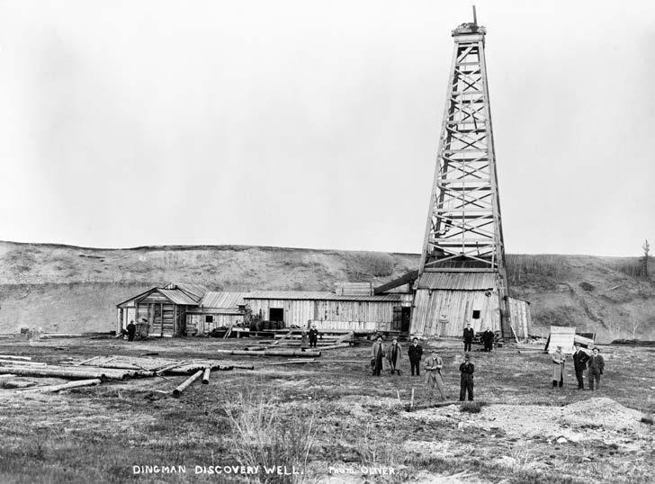
Visitors to Dingman #1 (Calgary Petroleum Products #1) well, Turner Valley, Alberta, 1914. Photographer: W.J. Oliver. Image NA-952-2 courtesy of Glenbow Archives.
activity, employment and financial rewards to individuals, companies and governments. The field was also important in other ways because of the timing of its life relative to global events. Its main period of exploration and production occurred in part during the Depression and brought much needed relief to southern Alberta. During the Second World War, the refining of crude oil production from Turner Valley was critical in the establishment and capacity of the British Commonwealth Air Training Program that was vital to the Allied war efforts. Finally, as the home of the first full scale commercial petroleum production facilities in Alberta, it positioned both the industry and the government for the rapid pursuit, beginning in 1947, of Leduc and other world class discoveries. Human, physical and capital resources were all quickly re-deployed from Turner Valley in the declining years of its life. Indeed the C.S.P.G. owes its establishment in 1927 to the activity generated by the 1924 natural gas discovery. Likewise Alberta’s regulatory regime for the industry became firmly established in 1938 in recognition of the fact that conservation measures were required to combat wasteful approaches so as to achieve optimal recovery efficiencies of subsurface resources, a need reinforced by the 1936 crude oil discovery.
It is important to examine Turner Valley in its broader societal context as well. In 1912 there
was so little petroleum in western Canada that the City of Calgary could not afford to purchase oil to keep down the dust on its streets. As a result, the 1914 discovery of the first commercial accumulation in the West bearing liquid hydrocarbons changed our local society forever. Historian David Finch will recount stories that illustrate the social, economic and political changes that happened in Alberta as the result of this discovery. One century later, our society is firmly based on petroleum.
BIOGRAPHY
Clinton Tippett is a petroleum geologist employed by Shell Canada currently working as
Project Coordinator in the Central Mackenzie Valley, NWT. He has a B.Sc. and an M.Sc. from Carleton University in Ottawa, Ontario and a Ph.D. from Queen’s University in Kingston, Ontario. Clint is President of the Petroleum History Society and Chair of the C.S.P.G. History and Archives Committee.
David Finch is a public historian and holds the M.A. in Post-Confederation History from the University of Calgary. He is the author of more than twenty books on the history of the Canadian West, including several on the oil industry including Hell’s Half Acre: Early Days in the Great Alberta Oil Patch.

RESERVOIR ISSUE 05 • MAY 2014 9
Clinton Tippet
David Finch

CSPG Continuing Education
2014 Spring Short Courses
Facies Architecture and Sequence and Stratigraphy of Delta System: From Exploration to Reservoir Performance ***NEW COURSE
Janok P. Bhattacharya
Clastic Facies and Depositional Environments in Core
Bill Arnott
Evaluating Source Rocks in a Risk Analysis Framework ***NEW COURSE
Nicholas B. Harris
SAGD Fundamentals - Application of Core, Geology, Geophysics and Geochemistry
Rudy Strobl, Milovan Fustic and Daryl Wightman
Dynamics of Subsurface Flow of Water and Hydrocarbons ***NEW COURSE
Udo K. Weyer
SAGD - Reservoir Engineering for Geoscientists & Non Reservoir Engineers ***NEW COURSE
Hussain Sheikha
2014 Spring Field Seminars
Turner Valley’s Centennial, A Field Trip through Changing Interpretations and Unchanging Rocks ***NEW COURSE
Paul MacKay, Clinton Tippett
SAGD Fundamentals - Field Seminar in Fort McMurray, Alberta
Rudy Strobl, Milovan Fustic and Daryl Wightman
2014 Summer Field Seminars
Geology of the Mount Stephen Trilobite Beds and Adjacent Strata
Allen Kimmel
More to come…
Registration Information
Registration for all CSPG Con-Ed Courses & Field Seminars is available online at www.cspg.org and through registration of the GeoConvention: FOCUS 2014
TECHNICAL LUNCHEONS JUNE LUNCHEON
Ancient Backwaters and Baylines: Slope Magnitude and its Control on Facies
Partitioning in Ancient FluvioDeltaic Systems
SPEAKER
Janok P. Bhattacharya
McMaster University
11:30 am
Tuesday, June 3rd, 2014 Calgary, TELUS Convention Centre Macleod Hall C/D Calgary, Alberta
Please note: The cut-off date for ticket sales is 1:00 pm, three business days before event. [Thursday, May 29, 2013]. CSPG Member Ticket Price: $45.00 + GST.
Non-Member Ticket Price: $47.50 + GST.
Each CSPG Technical Luncheon is 1 APEGA PDH credit. Tickets may be purchased online at https://www.cspg.org/eSeries/source/Events/ index.cfm.
ABSTRACT
A common observation in many ancient clastic wedges is that shoreline deposits are
ROCK SHOP
commonly significantly finer than associated fluvial deposits. Abrupt downstream fining in rivers, and increase in tidal or marine influence, may mark the backwater and bayline limits, which are controlled primarily by slope, tidal range, and river discharge. The backwater distance, from the shoreline, is defined as the ratio of river depth versus slope, whereas the bayline is the tidal range divided by the slope. In Modern continentalscale low slope river systems (i.e. Slope < 0.0001), such as the Mississippi and Amazon, backwaters may reach many hundreds of kilometers upstream, whereas they may be on the order of a few kilometers in steeper gradient systems.
Ancient deltaic systems of the Cretaceous interior seaway of North America, including the micro-tidal Turonian Ferron Sandstone Member in Utah, show coarse-grained pebbly-sandstone bedload river deposits that feed medium-to fine-grained sandy shorelines. Cross-sections allow estimates of channel depth and width, which can used to calculate the cross-sectional area of a channel. Grain size and bedforms can be used to estimate flow velocity. When multiplied by the channel area, the velocity can be used to estimate discharge. Ferron trunk channels are on the order of 5-9 m deep with discharge (Qw) of less than about 1500 m3/s. This suggests moderate size upstream drainage basins and a propensity for downstream, distributary channels to produce hyperpycnal deltaic deposits.
Within the Ferron clastic wedge, the pebble-to sand transition lies several kilometers from co-eval shoreline deposits,
Webcasts sponsored by
suggesting a short backwater length. Slope estimates can also be made based on onlap distances of associated coastal prisms, as expressed in stratigraphic cross sections. For the Ferron, slopes > 0.001, are an order-of-magnitude steeper than for the low-gradient continental scale systems, like the Mississippi. This explains the position of the transition from pebble- to sand in the fluvial systems, at a few versus hundreds of kilometers from the shoreline, as well as the lack of pebbles in co-eval shorelines. Onlap limits of bay and lagoon deposits, of several tens of kilometers, mark the bayline and suggest an average tidal range of < 2m.
The Cenomanian Dunvegan Formation, in Alberta, contains trunk streams on the order of 10-28 m deep. Discharge estimates are correspondingly about 3 times larger that the Ferron sandstone. Brackish water indicators have been found several tens of kilometers inland, suggesting the bayline was about 30km from the shoreline. Previous estimates of Dunvegan valley slopes are on the order of 0.0004, higher than the Mississippi, but lower than the Ferron. The gravel-sand transition lies considerably farther landward as well, suggesting backwater distances might have been on the order of 100 km.
Estimation of slope and discharge thus can be made in ancient clastic systems and allow prediction of the partitioning of coarse versus fine-grained facies at choke-points, as defined by the backwater and bayline limits.

RESERVOIR ISSUE 05 • MAY 2014 11
210, 237 – 8th Ave. S.E. Calgary, AB T2G 5C3 Phone: 403.263.5440 Fax: 403.263.2331 m.sahota1@shaw.ca
DIVISION TALKS
Brazil’s Deepwater
Pre-Salt Oil Play as a Model for Pre-Salt Oil Exploration in Deepwater West Africa
SPEAKER
Tako Koning, P.Geol.
Principal Consultant and Business Development Manager Gaffney, Cline & Associates (GCA) Luanda, Angola
12:00 Noon
Wednesday May 21st, 2014 Nexen Plus 15 Conference Centre Nexen Annex Building 7th Ave. & 7th Street SW Calgary, Alberta
ABSTRACT
The deepwater pre-salt oil play in Brazil has captured the attention of petroleum geoscientists worldwide. Since South America and West Africa were juxtaposed prior to continental separation in the midCretaceous, there is much commonality in the geology of both areas. Accordingly, when the super-giant Tupi oil field (now renamed Lula after President Lula) was
ROCK SHOP

discovered in 2006, not surprisingly West Africa’s pre-salt sedimentary sequences became the focus of intense interest by the oil industry.
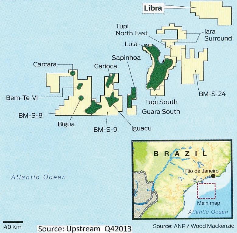
This presentation reviews public domain geological, geophysical and reservoir data of some of Brazil’s major pre-salt discoveries including Lula and Libra. Also recent pre-salt discoveries in West Africa are reviewed.
LULA FIELD
This field was discovered in 2006 in 2,170 meters of water depth and is Brazil’s first
super-giant oil field. The reservoirs consist of heterogeneous Cretaceous-age microbial carbonates located beneath 2,000 meters of salt. According to Petrobras, the Lula field has recoverable reserves of 5.3 billion barrels oil and 6.9 trillion cubic feet of gas. Petrobras (65% working interest) operates the field on behalf of partners BG Group (25%) and Galp Energia (10%). Two FPSOs (Floating Production Storage & Offloading), Lula pilot and Lula NE, are currently producing the Lula field. The wells in Lula have the potential to produce up to 30,000 bopd per well.
PRACTICAL LOG ANALYSIS COURSES
Quantitative Log Analysis: 14 – 16 Apr 2014
of Unconventional Reservoirs: 17 Apr 2014
and Registration at: www.spec2000.net/00-coursedates.htm
12 RESERVOIR ISSUE 05 • MAY 2014
INTERNATIONAL DIVISION
Sponsored by
petrographical & sedimentological descriptions for samples (thin section - fluid inclusion studies) conventional vertical/horizontal wells operations geology SPECIALIZED IN GEOLOGICAL WELLSITE SUPERVISION AND CORE ANALYSIS
our best friend and most valuable partner is our client Stephan C. Dragomir president www .g e ok2. c om - phon e : 403.831.9941 - s dr a gomir @ g e ok2. c o m
RockWell Consulting
For Engineers, Geologists, Geophysicists,
Practical
Details
In-House
Multi-Media Narrated Self-Study
Also Available === Instructor:
ross@spec2000.net === – 50 Years Worldwide Experience – Analysis, Training, Mentoring, Forensic Reviews –
and Technicians
Analysis
and
Courses
E. R. (Ross) Crain. P.Eng. 1-403-845-2527
LIBRA FIELD
Petrobras, on behalf of the Brazilian regulator Agencia Nacional do Petroleo (ANP) discovered Libra in 2010 in 2,000 meters of water. The discovery well intersected a continuous oil column of 325 meters in carbonate rocks below the salt. Test results indicated good quality light oil with 27 degree API. In October, 2013 a consortium of Petrobras (40%), Shell (20%), Total (20%), CNPC (10%) and CNOOC (10%) was awarded a 35-year production sharing contract to develop Libra. The consortium agreed to pay to Brazil’s government a signature bonus of $6.7 billion for the field rights. Shell has described the field as one of the largest deepwater oil accumulations in the world. According to ANP, Libra has the potential of 8 to 12 billion barrels of recoverable oil resources. Libra’s total gross peak oil production could reach 1.4 million bopd, according to ANP.
BRAZIL’S PRODUCTION
Brazil currently produces almost 400,000 bopd from pre-salt reservoirs in the Santos and Campos Basins. Brazil’s total oil production is currently 2.2 million bopd. The country’s current consumption is met by its current production. Had Lula not been discovered and had the follow-up presalt fields not been discovered, then Brazil’s current oil production would have declined to 1.8 million bopd which would have had a major negative impact on its balance of trade due to the need to import 400,000 bopd. Petrobras forecasts that Brazil’s presalt oil production will reach 1.0 million bopd by 2017 and to increase to 2.1 million bopd by 2020. Indeed, Petrobras has set a very ambitious goal which is to achieve by 2020 a production level of 4.2 million bopd of pre-salt and post-salt oil production.
WEST AFRICA
Across the South Atlantic Ocean from Brazil the oil industry is keenly watching to see if Brazil’s success will be duplicated in West Africa. Certainly some of the initial pre-salt drilling in Angola has been encouraging with Maersk Oil in 2011 testing 3,000 bopd from its Azul-1 well and in 2012 Cobalt Exploration testing 5,000 bopd from the Cameia-1 well and announcing that the well had the capacity to flow at 20,000 bopd. Also encouraging has been the recent announcement by Total that the Diaman-1 well, the first well to explore in the pre-salt of deepwater Gabon, encountered up to 55 meters of gas and condensate pay in pre-salt sandstones thus confirming the existence of a working petroleum system. Major presalt drilling programs will be carried out in
West Africa in 2014 and 2015, especially in Angola’s deepwater Kwanza Basin, and this will conclusively reveal if Brazil’s pre-salt successes extend into West Africa.
Robust pre-salt oil seeps at the Libongos asphalt quarry located 70 km NE of Luanda. Areas which were inaccessible during Angola’s long civil war (1975 – 2002) due to security issues and landmines, have been demined and are now accessible for geological research and field trips.
BIOGRAPHY
Tako Koning is Holland-born but Alberta-raised with a B.Sc. in Geology from the University of Alberta and a B.A. in Economics from the University of Calgary. He joined the oil industry in 1971 and has worked for 43 years (non-stop). He began his career working as a mud logger (“gas sniffer”) for Continental Laboratories on offshore wells on the Grand Banks of Newfoundland and then worked for 30 years for Texaco in technical, management and executive positions in Canada, Indonesia, Nigeria and Angola. He has lived and worked in Africa since 1992. In addition to working for GCA in Luanda, he is also much involved with technology transfer by being an active board member on the Luanda sections of the SPE, AAPG, and SPWLA. He also frequently leads geology field trips for oil industry professionals, university students and the public-at-large. The field trips visit Cretaceous carbonate outcrops and pre-salt oil seeps located northeast of Luanda as well as Tertiary (Miocene) shallow marine sediments south of Luanda.
Tako’s first presentation to the CSPG International Division was in 1987 and
this presentation is the 17th time he has presented to the Division. Over the years he has authored and co-authored over 100 abstracts, papers and technical articles. Tako is a long-time member of the CSPG and CSEG and also is a member of SPE, SEG, HGS, and PESGB. He is a Fellow of the Geological Society of London (GSL), Honorary Life Member of the Nigerian Association of Petroleum Explorationists (NAPE), and for the past 43 years has been a member of the Association of Professional Engineers and Geoscientists of Alberta (APEGA).
INFORMATION
There is no charge. Please bring your lunch. The facilities for the talk are provided complimentary of Nexen, coffee by IHS and refreshments by Geochemtech Inc. The speakers are provided with gifts by Drilling Information and McLeay Geological, and a door prize by Sigma. For further information or if you would like to give a talk, please contact Bob Potter at (403) 8639738 (ropotter@geochemtech.com), Kevin Morrison at (403) 536-3788 (morrison@ antrimenergy.com), Jűrgen Kraus at (403) 808 5086 (jkraus@me.com), Jon Noad (403) 513 7541 (jon.noad@huskyenergy. com) or visit our Linkedin page (“CSPG International Division”).
RESERVOIR ISSUE 05 • MAY 2014 13
Some Methods for Representing Geology in your Geostatistical Models
SPEAKER
Tom Cox
Schlumberger Information Solutions
12:00 Noon
Wednesday May 21st, 2014
Location TBA Calgary, Alberta
ABSTRACT
In the battle to increase hydrocarbon recovery from reservoirs, production has shifted to enhanced recovery techniques, such as horizontal drilling, fluid flooding and thermal heating. At the same time new reservoir production methods have become mainstream to access hydrocarbons that were previously unattainable. For example SAGD and Cyclic steam injection have unlocked the oils sands while horizontal drilling and hydraulic fracturing is accessing the oil shales. All these innovations have pushed up the density of well penetrations and produced a need for understanding the spatial reservoir properties. Large cell tank models for fluid flow simulation are not sufficient for today’s detail recovery practices. The needs of fluid flow models that represent the reservoir production require accurate characterization of the reservoirs.
Reservoirs have traditionally been represented by maps of their characteristics. Maps are able to quickly convey overall geometries, properties and trends. Maps, however, lack the vertical reservoir details required by today’s fluid flow
modeling. The 3D cellular model is able to represent these details in both the vertical and horizontal space. With the development of 3D modeling software it has become common and easy to create three dimensional representations of the reservoir characterization. These models are often driven by geostatistical engines, and it is the role of the modeler to make sure that the output represents not just the statistics, but the larger scale information contained in the traditional maps.
This talk investigates methods for identifying and capturing the larger scale trends into 3D cellular models. The presentation will look at techniques to recognize and combine geologic knowledge with geostatistical modelling; including, variogram analysis to recognize trends, the effect of transforms on the variograms, and how maps can be incorporated as trends or secondary variables.
The ambition of this talk is to get the geoscientist, who is a novice at 3D cellular modelling, thinking about how their geologic knowledge can be
incorporated into the 3D cellular model that are often driven by geostatistical engines. It is the role of the modeler to make sure that the output represents not just the statistics, but the larger scale information contained in the traditional maps and ultimately the reservoir.
BIOGRAPHY
Tom Cox has been working with Schlumberger Information Solutions since 1992, providing technical support and workflow solutions to oil and gas companies across Canada. Focused on the integration of seismic and well data for the characterization of reservoirs, he has worked extensively with the Petrel Platform and GeoFrame applications helping clients achieve an integrated understanding of their reservoirs. Prior to Schlumberger, Tom worked as a geophysicist for Imperial Oil Limited in the Western Canada basin and East coast offshore. Tom graduated from the University of Western Ontario with Bachelor of Science (1985) and Masters of Science (1988) degrees in Geophysics, and completed the Citation Program in Applied Geostatistics at the University of Alberta (2008).
14 RESERVOIR ISSUE 05 • MAY 2014
TALKS GEOMODELING DIVISION Sponsored by
DIVISION
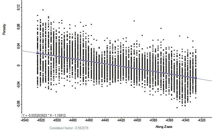
Figure 1. General porosity trend with depth.
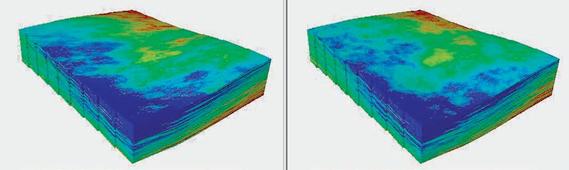
Figure 2. Input Truth model on the left with a model recreated from sampled data on the right.
ROCK SHOP


RESERVOIR ISSUE 05 • MAY 2014 15
• Domestic and International wellsite supervision • Conventional and Unconventional wells • Extensive Hz experience • Customized corporate solutions available (403) 250-3982 sales@clconsultants.ca www.clconsultants.ca 1602 – 5th St N.E. Calgary, AB T2E 7W3 Phone: 403-233-7729 www.tihconsulting.com e-mail: tih@shaw.ca T.I.H. Consulting Ltd. Geologic Well-Site Supervision CanRock Geo Inc. Log Analyst & Wellsite Geologist www.CanRockGeo.com info@CanRockGeo.com 1.403.813.0947 Onsite & Remote Geo-Steering Conventional Vertical & Horizontal Oil Sands & Heavy Oil Core & Cuttings Analysis Project Supervision SAGD / Horizontal Specialty in HZ Wells-Viking, Cardium, Mannville, Bluesky & McMurray CHAD Data Magnetic & Gravity data for the Western Canadian Basin John W. Peirce, P. Geo. Chief Geophysicist www.chad-data.com 250.616.6914 742 Memorial Drive NW Calgary, Alberta T2N 3C7 P: 403 242 1522 F: 403 242 8223 E: office@chinookconsulting.ca www.chinookconsulting.ca SERVICES • Wellsite geological supervision • Core and cuttings petrographic studies • Operations geology • Remote geo-steering and remote geological supervision • Project management Wellsite Geologists Inc. the Rock Solid Choice Wellsite Supervision Project Management Graphic Well Profiles Verticals / Horizontals EUB Sample / Core Studies Conventional / Un-conventional 1350, 734 - 7th Ave SW Calgary, AB T2P 3P8 B 403.234.7625, www.WellsiteGeologists.com C 403.660.9883, info@WellsiteGeologists.com
Sponsored by
Geomechanics and Fractured Reservoirs:
Comforting, Confusing, or Scary?
SPEAKER
Gary D. Couples
Heriot-Watt University, Edinburgh, Scotland
12:00 Noon, Friday, May 23, 2014
NEW Location:
Schlumberger, Conference Room, Second Floor, Close to Reception. 200, 125 – 9 Avenue S.E., Calgary, AB
ABSTRACT
Fractured reservoirs are known to exhibit changes in their characteristics during the production life cycle. Attempts to explain this behaviour using simple rules are usually not successful, and ultimately they are doomed, because the rules are based on assumptions that are physically impossible. Moving to the next level requires a change of mindset that involves abandoning the notion that geomechanical processes are governed by a constant state of stress. Using simple models and realistic conditions, and considering fractured rock
masses and their contained fluids, we can understand how the coupled systems interact, leading to realistic upscaled responses. Many real-world fractured reservoirs may have large parts where the fracture distribution and flow conditions never provoke any major surprises, so this is a comforting result and we can make sensible predictions. Other parts of those reservoirs, and larger portions in some cases, can exhibit confusing responses that can only be explained by considering the geomechanics/fluid interactions. Some parts of some reservoirs seem determined to scare us by their seeminglyunreasonable behaviours. By gaining an understanding of the process interactions that occur in fractured reservoirs, we can protect ourselves from the fear of the unknown – and we may be able to use this knowledge to be more effective in planning our reservoir management tasks.
BIOGRAPHY
Gary Couples is Professor of Geomechanics at Heriot-Watt University’s Institute of Petroleum Engineering. where he works at the engineering-geology interface. He holds a MA from Rice University and a PhD from Texas A&M. He was employed at Cities Service (Tulsa) and Amoco (Denver), and then ran a consultancy, before joining the academic world in 1989, first at Glasgow University in Scotland, before moving to Heriot-Watt (Edinburgh) in 1998. He teaches on four Master’s programmes at Heriot-Watt (lecturing to both engineers and geoscientists),
and also on a geomechanical Master programme at the Universite of Grenoble in France, along with delivering industrial short courses around the world. His geomechanical research activities range from experimental work (and apparatus development) through to numerical simulation at many scales. His approach links geomechanical effects to their consequences: predicting flow and other properties. Textural analysis and digital rocks play a key role in this activity. He has been an invited keynote speaker at many conferences, and he enjoys talking about challenging topics.
INFORMATION
Structural Division talks are monthly-ish and cover a diversity of structural themes. Our Structural Division sponsors are HEF Petrophysical and Husky Energy. All are welcome and no registration is required. For additional information, to be placed on the Division e-mail list or to present a talk, please contact Darcie Greggs, Darcie. Greggs@huskyenergy.com.

CSPG Awards Reception
Monday, May 12, 2014
5:30pm – 7:00pm
HYATT Regency Calgary, Imperial Ballroom 5
Join us in honoring the 2013 CSPG award recipients.
Everyone is welcome to attend.
16 RESERVOIR ISSUE 05 • MAY 2014
DIVISION TALKS STRUCTURAL DIVISION
The tournament would like to thank the following 2012 Sponsors:
Diamond Sponsors
Schlumberger of Canada geoLOGIC Systems
Little Rock Document Services
Emerald Sponsors
Weatherford Canada
Partnership
RECON Petrotechnologies Ltd.
RBC Dominion Securities
ProGeo Consultants
MJ Systems
AGAT Laboratories IHS
Platinum Sponsors
ZIPCASH
West Canadian
Paradigm Geophysical
ATB Financial
GLJ Petroleum Consultants
Gold Sponsors
Arcis Corporation
Canadian Discovery Ltd.
ConocoPhillips Canada
Continental Laboratories
Datalog Technology Inc.
Frank Pogubila
Greystone Resources Ltd.
Knowledge Energy Ltd.
Total Gas Detection Ltd.
Seismic Brokerage Services
Silver Sponsors
Cambria Business Services
Gabel Energy Inc.
Bronze Sponsors
Canadian Stratigraphic Services
Fekete Associates
Halliburton Group Canada
GeoStrata Resources Inc.
Energy Navigator
Divestco Inc.
Baker Hughes
Belloy Petroleum Consulting
Belgo Brasserie
LXL Consulting
Pason Systems Corp.
McLeay Geological Consulting
National Oilwell Varco
Painted Pony Petroleum Corp.
Pajak Engineering Ltd.
Rigsat Communications
Rockwell Consulting
Sample Pro Ltd.
Sproule Associates Ltd.
Typhoon Energy Ltd.
Global Energy Services
Martin Quinn
Hydro-Fax Resources Ltd.
San Dago Resources Ltd. Sponsorship
Register Online at cspg.org
Go to Events/ Sporting Events/ Classic Golf.
To complete registration login to the website with your CSPG member ID.
Please call (403) 513-1233 for assistance.
Registration Includes
2 rounds of golf at Elbow Springs Power Cart
Driving Range
Golf Shirt
Steak Dinner at Elbow Springs
Breakfast at Elbow Springs
Awards Banquet at The Petroleum Club (for you and your guest)
Draw Prizes
Daily Skill Prizes
Sponsorship Tents, prizes and gifts AND
Chance to win two separate draw prizes to any North American Destination
Tournament
*All prices include GST
*Discounts for students, first time players and previous players who refer a first time player.
Social events cancellation or additions require 72 hours notice before the event. Please contact Scott Thain (403) 262-9229, cell (403) 999– 8558 or email: cspgclassicgolf@gmail.com
Last day for refunds Friday June 13, 2014
RESERVOIR ISSUE 05 • MAY 2014 17
Fee: Member Non Member $309.00 $329.00
Welcome, Contact James Ablett (403) 290-7670 Visit us on Facebook or Linkedin: CSPG Classic Golf In 2014 the charity selected is the CSPG Educational Trust Fund 53rdCLASSIC2014 53rd ANNUAL CSPG CLASSIC Elbow Springs Golf Club • June 19-20, 2014 cspg.org

IHS Energy is the industry’s authoritative provider of analytics, insight and solutions, scaling across virtually any operation and enterprise, from ground level tactics to high level strategy.
Industry-leading applications such as IHS AccuMap® and IHS Petra® enable you to take your geological and engineering capabilities to the next level, using Canada’s most trusted and complete exploration and production data.
INFORMATION ANALYTICS EXPERTISE to learn more, visit ihs.com/energy GeoConvention 2014 MAY 12-14 BOOTH 525FORA VISIT FREE GIFT
AccuMap®
Shaped by Industry and Powered by IHS Information
Developed with extensive industry feedback, the new IHS AccuMap® provides a completely new user interface with a more flexible and powerful interpretation application for both conventional and unconventional plays. Continue to access the best quality data in an easier to use interface to generate accurate, presentation quality maps that get you to the right decision faster.
With the new AccuMap, access enhanced mapping and plotting functionality with editable contours, flexible postings, transparency for all layers, and a new web mapping services connection that enables you to connect to spatial content over the internet. Never before have you been able to view multiple datasets with ease and quickly see the big picture opportunity.
Regardless of your discipline, IHS AccuMap is the flexible, powerful mapping solution to help you find opportunities and make critical business decisions faster.
ihs.com/accumap
Petra®
You tackle tough problems
Your geoscience software doesn’t have to be one of them
IHS Geoscience is the industry’s leading geoscience interpretation solution, incorporating superior science with trusted E&P data and spanning geological and engineering capabilities.
Whether you are prospecting for new discoveries or exploiting reserves already discovered, IHS Petra is the geological interpretation tool of choice that continues to help reduce risk and increase the accuracy of business decisions that are made in today’s progressively fast-paced environment. IHS Petra continues to deliver reliable, easy-to-use workflow improvements that provide an all-encompassing geological solution for the exploration, development and production analysis needs of our industry. With enhancements that leverage multiple web mapping services, raster log interpretation efficiencies, and additional unconventional workflow optimization, the new release of Petra continues to reflect the ideas and objectives of our customers now, and for years to come.
ihs.com/petra
FOSSILS HUNTING FOR PROVINCES
| By Jon Noad, Husky Energy
INTRODUCTION
Forty states in the US have an Official State Fossil. These include ten states using dinosaurs or their trackways, one using a marine reptile, seven using fossil mammals, two using fossil fish, thirteen using invertebrates and two using fossil plants. There are 10 states in total without a state fossil, but only one state, Kansas, that does not at least have a state rock, gemstone or mineral.
Now ask yourself how many provinces and territories in Canada have designated a Provincial or Territorial Fossil? Surprisingly the answer is only ONE, Nova Scotia, which designated the oldest known reptile in the world, Hylonomus lyelli, as the official fossil of the province in May, 2002. Despite Canada’s extraordinary geological heritage, no other province has taken the plunge and chosen a fossil to represent them. Below are some possible suggestions for each province or territory to fire your imagination. If you feel strongly about this I urge you to lobby your provincial government officials, or at least to come up with your own favourites during discussions in your local hostelry.
I derived much of the information in this article from the internet, and advise interested readers to browse further. In addition why not visit the various provincial geological museums in which many of the fossil specimens are housed?
ALBERTA
Alberta has a wealth of geology stretching back into the Precambrian. The Rockies expose a series of Cambrian sediments, as well as thick, overthrusted limestones and shales from the Devonian to Carboniferous periods. These include many invertebrates, some reef-forming. Triassic rocks can be viewed around Jasper, and old coal workings from Crowsnest to Canmore are a testament to Jurassic deposition during regional uplift, as the Rockies foreland basin developed. A suite of Cretaceous rocks fill the associated foreland basin, becoming more marine in character to the east. Deposition continued into the Palaeocene, after which little was preserved until Quaternary glacial deposits.
Two types of fossils come immediately to mind when considering Alberta’s ancient life. The first is the ammonite Placenticeras, which yields the opal-like organic gemstone ammolite. This mineral has been given official
gemstone status by the World Jewellery Confederation, and is the official gemstone of Alberta (nearly a Provincial Fossil but not quite). Ironically Alberta’s Provincial Mineral is also a fossil – petrified wood. Ammolite is produced commercially from the Cretaceous Bearpaw Formation. The second type of fossil is dinosaur remains, with more than 40 dinosaur species having been discovered in the World Heritage Site of Dinosaur Provincial Park alone. Of course there are many other fossils in the province, spanning a time period from Precambrian to Quaternary, but to do them justice would require an article of their own.
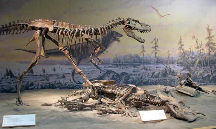
Ammolite is already the Provincial Gemstone, and therefore a dinosaur is considered the preferred choice as a Provincial Fossil. Suitable candidates include Albertosaurus (though not definitely present in the Park) and Gorgosaurus, which are very similar sister taxa. Other potential choices include a variety of ceratopsians such as Chasmosaurus and Centrosaurus, Stegoceras (a pachycephalosaur) and the ankylosaur Euoplocephalus, all of which were first reported from the Park. In light of the abundance of bone beds dominated by Centrosaurus remains, this animal is nominated as the Provincial Fossil. It brings to mind images of herds of thousands of these mighty beasts migrating across the ancient Albertan Plains.
BRITISH COLUMBIA
The geology of British Columbia owes everything to its location on the leading edge of the North American continent. Five separate belts define the geology, including accreted terranes. The geology is complex,
often metamorphosed, and stretches from the Precambrian to Recent in age. A rifting phase commenced with deposition of the 1.4 billion year old Windermere Supergroup, and then continued through deposition of the thick Palaeozoic to early Mesozoic carbonate and terrigenous clastic strata now exposed in the Rockies. Associated basalts and granites are common.
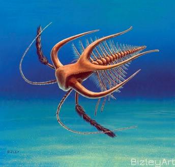
Three BC geologists have put together a great website (http://www.bcfossils.ca/fossil. html) supporting their nominees for the BC Provincial Fossil. Thanks to all the work that they have done I do not propose to add any extraneous candidates to their list, beyond a possible alternative Burgess Shale fossil. Their candidates are the Permian fusilinid Yabeina; the Cretaceous ammonite Canadoceras; the Cambrian “lace crab” Marrella; and the Cretaceous elasmosaur. Their website explains
20 RESERVOIR ISSUE 05 • MAY 2014
Figure 1: Centrosaurus, Alberta’s candidate, lies vanquished by Gorgosaurus. Photo by François Therrien, Royal Tyrrell Museum.
Figure 2: Reconstruction of Marrella from the Burgess Shale, selected as one of the candidates for BC’s Provincial Fossil. Painting by Richard Bizley.
the rationale behind the nomination of each of the four fossils.
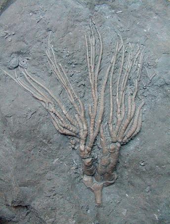
The Burgess Shale is probably the most famous formation in Canada, and as such the author supports the nomination of Marrella, or failing this the carnivorous Anomalocaris from the same formation, as the provincial fossil. Marrella is one of the most abundant of the Burgess Shale fossils, and its unusual morphology was one of the triggers that sparked the questions as to the “experimental” nature of the morphology of many of the associated organisms. The story of the unique faunal explosion at this time, preserved in and around Walcott’s Quarry, has enthralled geologists and the public alike.
MANITOBA
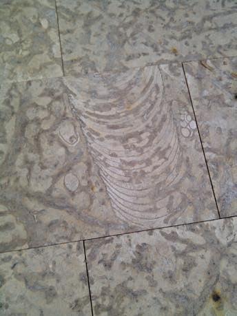
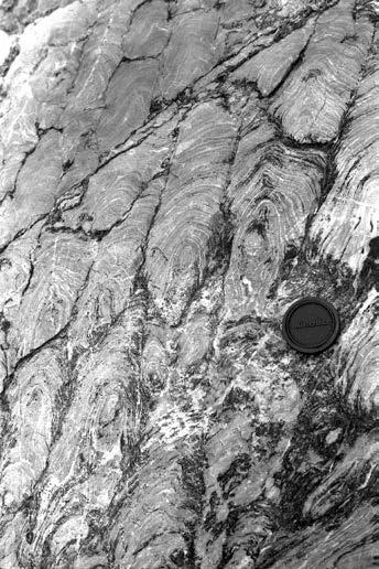
Ordovician limestone mined around Garson, Manitoba. It is cream in colour, with striking, dolomitic mottling caused by the burrows of fossil shrimps (probably Thalassinoides), as well as other body fossils, including cephalopods, gastropods and corals. It was deposited in a shallow, warm, inland sea. As Manitoba’s most exported trace fossil, my nomination is the Tyndall Stone as Manitoba’s Provincial Fossil.
NEW BRUNSWICK
The geology of this province is similar in some respects to that of Nova Scotia. The
of sediment, and are beautifully exposed at three separate horizons on the coast. Modern analogues to these structures can be seen in Shark Bay in Western Australia.
NEWFOUNDLAND AND LABRADOR
The majority of fossils found in this province are of Palaeozoic age, including a wide variety
Three fifths of the province exposes Precambrian rocks, and outcrops of Phanerozoic and Cenozoic rocks are restricted. Unique Ordovician fossils have been collected from the western shores of Lake Winnipeg, representing a variety of invertebrate clades including beautifully preserved fossil jellyfish. Recent discoveries of both the large bony fish Xiphactinus and associated mosasaurs have been made in Cretaceous rocks of the Pembina valley, adding to marine fauna recovered over the years. The squid Tusoteuthis is also common in these rocks, along with ancient birds and turtles, but the star of the show is a 43 foot long mosasaur, “Bruce” the Hainosaurus, on display in the Canadian Fossil Discovery Centre.
The best travelled of Manitoba’s fossils is not a vertebrate, however, or even a body fossil. Visit almost any city in Canada and you will see buildings clad in Tyndall Stone, a dolomitic
oldest fossil forest in Canada is located in Stonehammer Park, with almost 700 trees, most in life position. Rare insect fossils have also been recorded from the Carboniferous. Trilobites have been found around the city of Saint John, in particular large Paradoxides specimens, together with graptolites and other Palaeozoic fauna. Some Cambrian limestone nodules preserve exquisite fossils, but exposures are rare. Probably of greatest significance are the fossils of mastodons, which have been found at Hillsborough. Similar fossils have also been reported from Nova Scotia, but there is certainly a case to be made for suggesting that the mastodon be designated as New Brunswick’s provincial fossil.
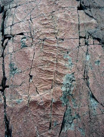
However, perhaps the best candidate as the provincial fossil would be Archaeozoon, the first stromatolite fossil and first Precambrian fossil to be correctly described (back in 1890), which can be found in limestone at Green Head in Stonehammer Park, near Saint John. The cabbage shaped mounds were built up by successive mats of cyanobacteria and layers
of trilobites, graptolites, brachiopods, bryozoa, corals, crinoids, cephalopods, molluscs and many more. Arguably the world’s best preserved archaeocyathids, which resemble hollow horn corals with a sponge-like morphology, are found on the Port au Port Peninsula and in the Forteau Formation of southern Labrador. The trilobite faunas of eastern and western Newfoundland contrast sharply in an example of faunal provincialism, because the two areas were originally in different climatic zones on opposite sides of the ancient Iapetus Ocean. Younger fossils are generally restricted to the Knob Lake District of western Labrador, which has also yielded Cretaceous insect and plant fossils. A few dinosaur bones were intersected by wells drilling on the Grand Banks.
Bell Island in eastern Newfoundland is world famous for its trace fossils, created mainly by trilobites. However of even greater significance is Mistaken Point, on the south-eastern tip of the island, which exposes the oldest complex life forms found anywhere on Earth. These animals lived at the bottom of a deep ocean, and were preserved by a series of ash falls. These are an Ediacaran biota, and have been subdivided into f ive groups based on their morphology: spindle-shaped, leaf-shaped, round lobate, dendrite-like, and radiating. By far the most common are the spindle shapes, which are
(Continued on page 22...)
RESERVOIR ISSUE 05 • MAY 2014 21
Figure 3: Orthocone nautiloid surrounded by Thalassinoides burrows, the main constituent of Tyndall Stone, and Manitoba’s chosen Provincial Fossil. Photograph supplied by Gillis Quarries.
Figure 4: The stromatolite Archaeozoon, the candidate for New Brunswick’s Provincial Fossil.
Photo by Brian Pratt.
Figure 5: A “spindle” from Mistaken Point in Newfoundland, the Ediacaran chosen as Newfoundland and Labrador’s Provincial Fossil.
Photo by Helen Goodchild.
unique to this locality, but have not yet been given an official scientific name. Despite this, due to its local abundance, significance and rarity, the Spindle is nominated as the Provincial Fossil.
NOVA SCOTIA
The geology of Nova Scotia is made up of three separate land masses that came together around 380 million years ago. Originally separated by the Iapetus Oean, crustal blocks (or terranes) were drawn together due to subduction, leading to ocean closure along the suture. The blocks
expose Cambrian turbidites and Ordovician shales, with localised Silurian sediments and volcanics. In the late Devonian a series of basins opened, and the grabens filled with volcanics and fluvial to lacustrine clastics. Few fossils were preserved. Tectonism halted in the Carboniferous, and post-rift limestones and regionally extensive evaporites were deposited. This was followed by Upper Carboniferous coal and clastic deposition, including the famous Joggins succession. Renewed extension of the Fundy Basin in the Triassic led to basins filled with pebbly sandstones, becoming aeolian upwards, overlain by shales and occasional basalts. Further terrestrial and lacustrine clastic deposition followed.
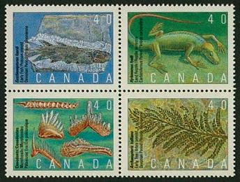
As mentioned above, this province is the only one to already have a Provincial Fossil. Hylonomus lyelli was declared the Provincial Fossil of Nova Scotia in 2002 by an Act of the House of Assembly. It is the oldest known reptile in the world, and its fossils were commonly found in hollowed out tree stumps, at the famous fossil cliffs of Joggins, by Sir William Dawson in the mid 1800s. It dates back 315 million years to the Carboniferous. There is speculation that the lizard-like animal may have taken shelter within the trees to escape forest fires.
Although some Precambrian fossils have been recorded from northern Ontario, the majority of fossils are found in Palaeozoic rocks (particularly the Ordovician) that were deposited in shallow seas. These include trilobites, graptolites, brachiopods, corals

22 RESERVOIR ISSUE 05 • MAY 2014
ONTARIO
Figure 6: Block of Canadian stamps issued in 1991 which show Nova Scotia’s Provincial Fossil (Hylonomus), as well as the candidate for Quebec’s equivalent (Eusthenopteron).
(...Continued from page 21)
Figure 7: The crinoid Cupulocrinus, selected as the candidate for Ontario’s Provincial Fossil. Photo courtesy of Eastern Ontario Natural History Society.
(reefs), molluscs and crinoids. Hundreds of localities have been described in the literature, including some quarries still working today. The region around Southampton is particularly well known for the Ordovician fossils that wash up on the beaches. There are also Quaternary deposits left by glaciers, in which occasional mammal bones can be found.
Probably the most stunning fossils from this province are the crinoids, which are beautifully preserved in the limestones. It is difficult to single out a particular genus, with over 40 types from the Ordovician and Devonian, but Cupulocrinus is fairly common, attractive to look at and often occurs en masse. There are other species that are considered equally deserving of Provincial Fossil status, but this crinoid wins my vote.
PRINCE EDWARD ISLAND
A fairly limited number of fossil localities have been recorded from PEI, the vast majority of which are of Permian age and have yielded poorly preserved fossil plants, notably Walchia and Tylodendron (the branching foliage and stem, respectively, from the same conifer). Vertebrate remains have been used to date the dominantly continental deposits. A single Early Permian reptile, Bathygnathus (closely related to Dimetrodon), was recorded from
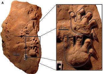
Figure 8: Ichniotherium, the diadectid trackway chosen as PEI’s Provincial Fossil. A, ROM 49281, complete block containing two trackways; B, closeup of the largest, best preserved footprints. Image by Jessica Hawthorn and Kirstin Brink, courtesy of the Royal Ontario Museum.
one locality, and vertebrate trackways have also been recognised. One of the tracks from near the town of Eldon was identified as Ichniotherium, thought to have been made by large Permian herbivorous diadectids, and the largest example known worldwide. It was found in association with some invertebrate traces called Striatichnium. In view of the size and preservation of the Ichniotherium tracks, this trace fossil has been chosen as the Provincial Fossil candidate.
QUEBEC
The majority of the rocks in Quebec are Precambrian in age, forming part of the
Canadian Shield. South-eastern Quebec exposes Palaeozoic rocks rich in fossils, including Devonian fish. Well preserved Ordovician and Silurian fossils are common in the Témiscamingue area. Mesozoic rocks are absent except inside an impact crater, as are most Tertiary rocks, although Quaternary deposits are common, and include marine sediments from periods of higher sea level.
Miguasha Park is a World Heritage Site (the only Devonian site), where the Escuminac Formation has yielded over 20 species of exquisitely preserved fossil fish including placoderms and bony fish. These include the “Prince of Miguasha,” Eusthenopteron foordi, whose limblike fins gave rise to the modern conception of evolution from fish to four-limbed, landdwelling vertebrates. All in all a fitting candidate for Le Fossile Provincial, and the only fish on our list to be nominated.
SASKATCHEWAN
The fossil record of this province covers 1.8 billion years. However most of the province is covered by glacial deposits, and river valleys are usually the only places where older rocks are exposed. Stromatolites are found in Precambrian rocks around Uranium City. Palaeozoic rocks are sparsely exposed, and
(Continued on page 24...)
the Duvernay Project
Work on Canadian Discovery and partners’ Duvernay Project is well underway. This study evaluates the Geomechanics, Hydrocarbon Systems and Geological Setting of the Devonian Duvernay Formation in the Kaybob to Willesden Green Area.
Results to date indicate:
» Variable lithology and a well-defined facies/ lithology dependent fracture fabric
» Stratigraphy shows a possible extension to the current play areas
» Geochemistry shows source rock maturity is strongly related to heat flow variations
A geomechanical evaluation, detailed geochemistry, hydrogeology and reservoir mapping will be completed prior to study delivery.
Subscribe now and qualify for pre-completion pricing
Contact Cheryl Wright cwright@canadiandiscovery.com | 403.269.3644

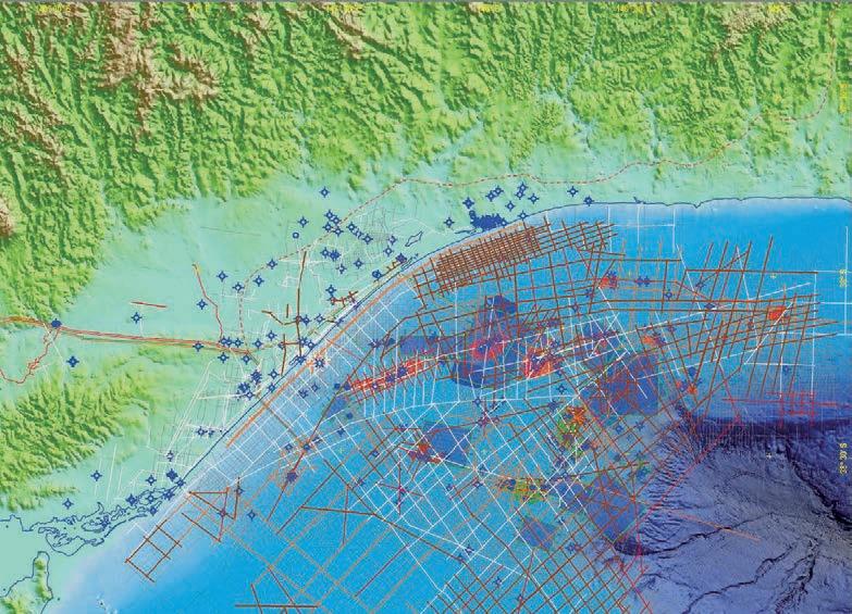
RESERVOIR ISSUE 05 • MAY 2014 23 (((( (((( ((((( ! ! ! ! ! ! ! ! ! ! ! ! ! ! ! ! ! ! ! ! ! ! ! ! !! ! ! ! ! ! ! ! !! ) " " " " ) " " " " " " ) ) " " ) " " " " " " " " " " " " " " )" ) " ) " " " " " " " " " " " " " ) " " " " " " " " " " " " " " ) " " " " " " " " " " " " " ) " " " " " " " " " " " " " " " " ") " " " " ) " " " " " " ") ) " " " " " " )" ) " " " " ") ) " " " ") ) " )" ) " " ") ) " " ) " " ) " " " " " " " " " " " " " " " " " " ) " " " " ! ! 30 35 35 30 30 35 30 35 35 35 35 30 40 35 30 35 35 35 35 30 40 35 30 35 35 30 30 35 30 35 35 30 35 35 35 35 30 30 30 35 25 35 35 30 30 35 35 35 35 25 35 35 35 40 30 30 30 35 30 35 35 35 35 30 30 40 30 30 35 35 35 30 30 40 30 30 35 30 35 35 30 35 35 35 35 35 35 30 30 40 30 35 25 35 30 40 35 30 30 35 40 40 35 30 30 30 35 25 35 35 35 35 30 30 40 30 35 35 25 30 40 30 35 35 35 35 35 30 35 30 30 30 35 30 40 35 35 35 35 35 35 30 30 35 25 30 35 40 35 35 30 35 35 35 35 30 30 35 35 30 25 35 30 35 25 30 30 30 35 35 35 30 35 40 35 30 40 30 40 40 30 35 35 40 30 35 40 30 40 40 25 30 40 35 35 35 35 35 30 30 35 30 25 30 30 35 30 30 30 30 30 35 30 30 35 35 35 35 30 30 30 30 30 35 82 75 92 142 109 202 300 289 Alberta British Columbia Wells ! Duvernay Producers " Duvernay Cores (Preliminary) Duvernay Geochemistry Data (GSC, AGS) Duvernay Muskwa Isotherms (°C) 60 100 Geothermal Gradient (All Units) °/1000m CI = 5 °C/1000m High 59 Structural and Geological Edges Leduc Reefs (WCSB Atlas, 1994) Duvernay Geothermal Gradient (All Units) Copyright 2013 Canadian Discovery Ltd. All Rights Reserved. Cartographer: Keeler 1 Created: 21-January-2013 Last Edited: 16-July-2013 T30 T45 T60 T65 T70 T75 R10 R20 R15 R10 R5 R1W5 R25 R15 T50 T40 T30 T35 R5 R1W6 R25 R20 R10W4 T80 T75 T70 T65 T60 T55 T45 R10W4 R15 R20 R25 R1W5 R5 R15 T35 T50 T55 West Shale Basin Basin Kaybob T40 Edson Karr Green British Columbia Manitoba Alberta Saskatchewan SaSkatchewan alberta britiSh columbia
TRICAN GEOLOGICAL SOLUTIONS Canadian Discovery Ltd. GRAHAM DAVIES CONSULTANTS LTD. GEOLOGICAL GDGC
Image Left: Geothermal Gradient (All Units)
(...Continued from page 23 )
host nautiloids and molluscs, though reefs are not always present. The marine environment became more saline throughout this time, leading to extensive potash deposits. Potash is Saskatchewan’s Provincial Mineral.
Rocks from the later Mesozoic are exposed in southern Saskatchewan, and those from around 90 million years ago, in the Pasquia Hills, have yielded marine fossils including a 7.5 m long crocodile, known as “Big Bert” (Terminonaris), as well as sharks, bony fish and toothed birds. Around 80 million years ago, some terrestrial deposits preserved dinosaurs, which were then overlain by more marine deposits with ammonites and new species of plesiosaurs as well as the mosasaur Tylosaurus. Further terrestrial sediments were deposited from 68 to 65 million years ago, and remains of Triceratops, Ankylosaurus and other herbivorous dinosaurs have been found. A partial skeleton, “Scotty”, a specimen of the most famous theropod, Tyrannosaurus rex , was discovered along the Frenchman River in 1991, although there are much better preserved T. rex specimens from South Dakota. Many other organisms are also preserved in these rocks, including a variety of fossil mammals.
Deposition continued through most of the Tertiary, with Saskatchewan preserving Canada’s best fossil record of this time period. Much of the sedimentary record is terrestrial, with many excellent mammal remains collected. A great locality is Calf Creek (Oligocene Cypress Hills Formation), where over 70 species of mammals, around 35 million years old, have been recorded, including brontotheres, rhinos, dogs, entelodonts, horses and rodents. Some of the most striking beasts are Hyaenodon (carnivorous hyenalike mammal), the entelodont Cypretherium, a giant pig-like predator, herds of camel-like Merycoidodon and Limnenetes, a sheep-sized, cud-chewing hippo-like oreodont sometimes referred to as a “dwarf hippo”. Deposition is not preserved from 14 to 2 million years ago, although many Ice Age species have been found including bison and mammoth.
It is not easy to single out an animal that represents the totality of the Saskatchewan fossil heritage. The popular vote would probably side with Scotty the Tyrannosaurus, although the Tertiary mammal fossils are undoubtedly more unique in global terms. The discovery of a potential T. rex coprolite in 1995, at Eastend, leaves me itching to nominate this “deposited” trace fossil for immortality as the Provincial Fossil, though somehow I don’t think that the provincial fathers would see the funny side. Thus the choice of Provincial totem falls to the potentially cute, “dwarf hippo-like” Limnenetes, honouring the unique mammals of the Calf Creek Local Fauna.
NORTHWEST TERRITORIES

NUNAVUT
Ediacaran fossils of the late Precambrian have been found in the Mackenzie Mountains, with disk-form, tentaculate and segmented forms present in rocks over 2.5 kilometres thick. These include the oldest known multicellular animal fossils in the world, soft cup-shaped animals living on the ocean floor. Sediments eroding from east and central regions during the Palaeozoic were deposited in seas to the west. The warm waters were host to many fish and invertebrates, including reef builders. Fossils have been collected from Devonian rocks in Norman Wells and elsewhere in the Territory, including many brachiopods from around Avalanche Lake. The Enterprise area of the Hay River is rich in Devonian fossil invertebrates. Most of the Territory was above sea level in the Mesozoic, but the Western Interior Seaway flooded parts of the region, bringing many fish, marine reptiles, aquatic birds and invertebrates. Some Cenozoic remains are preserved, including a 50 million year old redwood found in a kimberlite pipe at the Ekati Diamond Mine.
There is no doubt that a rich fossil fauna occurs in this region, but access is challenging. The Arctic islands are also likely to host a rich fauna, but are even more difficult to access. I found less data on fossils from NWT than from any other province or territory while researching this article. Correspondence with the NWT Geoscience office suggested a faithful brachiopod, Atrypa arctica, as their nomination. In a Territory rich in brachiopods why not nominate one common to the region, and one that in addition is named after the frozen North?
Fossils have been collected on Devon, Ellesmere and Bathurst islands. Many of these were of Devonian or older ages, although isolated fills of Miocene sediments have been recorded, as well as some Eocene plant remains. Generally the fauna is dominated by trilobites and brachiopods, with associated corals and molluscs, but the jewel in the crown is an extinct sarcopterygian of the Devonian, Tiktaalik. This lobe-finned fish is considered to be part of the lineage leading to the evolution of the tetrapods. This animal shares a number of fish-like and tetrapod-like characteristics and is a classic example of a key transitional fossil. Its original discovery led to worldwide news coverage.
However there is another unique palaeontological feature outcropping on Axel Heiberg Island. The Eocene fossil forests are redwood trees (Metasequoia), many of which are unmineralised. They appear to have been mummified in the cold Arctic climate, a somewhat unique form of wood preservation. They reach 40 m in length, and other elements, such as cones and leaves, are also preserved. This high latitude, wetland forest is a fitting Territorial Fossil, and the only plant on our list.
YUKON
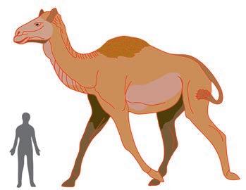
Figure 12: A reconstruction of a giant fossil camel from Old Crow Basin, which is the chosen candidate for the Yukon’s Territorial Fossil. Drawing by the author, after “Titanotylopus” by Carl Buell.
Most fossils found in Yukon are bones from Ice Age or Pleistocene mammals, typically mammoth, horse and bison, which lived in Beringia, the largely ice free region stretching from Siberia to the Yukon. A large collection
24 RESERVOIR ISSUE 05 • MAY 2014
Figure 9: Painting of an animal similar to Limnenetes, a small hippo-like oreodont selected as Saskatchewan’s Provincial Fossil. Painting by Robert Bruce Horsfall.
Figure 10: A sketch of Atrypa, the humble brachiopod selected as the NWT’s Provincial Fossil. Sketch featured in the Project Gutenberg Ebook.
Figure 11: Metasequoia forms amazing fossil forests on Axel Heiberg, and is the candidate for Nunavut’s Territorial Fossil. Photo taken by David Greenwood.
Alberta Cretaceous Centrosaurus Horned dinosaur
British Columbia Cambrian Marrella “Lace crab”
Manitoba Ordovician Tyndall Stone (Thalassinoides) Shrimp burrows
New Brunswick Precambrian Archaeozoon Stromatolite
Newfoundland and Labrador
Nova Scotia
Precambrian “Spindle” Ediacaran
Carboniferous Hylonomus Reptile
Ontario Ordovician Cupulocrinus Crinoid
Prince Edward Island Permian Ichniotherium Amphibian trackway
Quebec Devonian Eusthenopteron Lobe-finned fish
Saskatchewan Oligocene Limnenetes Dwarf “hippo”
Northwest Territories
Devonian Atrypa arctica Brachiopod
Nunavut Eocene Metasequoia Tree
Yukon Pleistocene Yukon giant camel Camel
Table 1: Proposed Provincial/Territorial Fossils of Canada
is housed in Whitehorse. Specimens of Ice Age plants have also been collected, along with fossil nests from Arctic ground squirrels. Many Quaternary sites have also yielded fossil insects, with assemblages dominated by beetles. Older fossils, such as dinosaur tracks from Ross River and Cretaceous marine reptile remains, have been found but are sparse.
A recent discovery was a foot bone from a horse, some 30% bigger than its distant relative, the modern horse. It was found at a placer gold mine on Thistle Creek near the Klondike. Like many Yukon fossils, the bone was found frozen in permafrost. Two types of fossil camel also made the headlines recently, including the Yukon giant camel, represented by bones from Old Crow, around a million years old. This camel is very similar to Titanotylopus of Nebraska, and was around
3.5 m tall. The second is Yesterday’s Camel, Camelops, which has been dated to around 90,000 years in age. Choosing a camel, in this case the Yukon giant camel, would certainly create a unique Territorial Fossil.
SUMMARY
Canada has an extraordinary geological heritage. Some of the best preserved Precambrian stratigraphy in the world was overlain by shales and limestones of the Palaeozoic, often hosting spectacular invertebrates. The Cretaceous of western Canada hosts many of the world’s best and most significant dinosaur assemblages, while Saskatchewan has yielded many of the world’s Tertiary mammal species. Finally there is no shortage of Ice Age mammal remains littering the continent. It is definitely about time that Canada paid tribute to its unrivalled fossil resources through the naming of the remaining Provincial and Territorial Fossils, adding to the
ROCK SHOP
current solitary Provincial Fossil, Hylonomus, from Nova Scotia.
The nominated fossils really do span the spectrum of fossil life in Canada, both in terms of age and complexity, ranging from the cyanobacteria that created the stromatolites of New Brunswick, to a primitive multicellular Ediacaran. There are invertebrates such as a crinoid, a brachiopod, a crustacean and shrimp burrows, and then a mix of vertebrates including fish, a dinosaur, reptile tracks and mammals. The chosen fish represents a key evolutionary “missing link”. Finally there is a tree to represent the ancient plants of the continent. The slight bias towards vertebrates is similar to that of the provincial fossils of the United States, and has been driven partly by the public appeal of “big fossils”. See whether you agree with the author’s choices, and please feel free to give some feedback. PROVINCE/TERRITORY

RESERVOIR ISSUE 05 • MAY 2014 25
AGE NAME POPULAR DESCRIPTION
Tools to tackle the riddle of the sands - now on your doorstep...
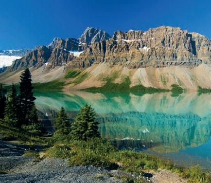
Chemostrat are proud to announce the opening of our new offices in Calgary.
With a dedicated team of geologists based on the ground in Canada, we’re now even better placed to deliver mineralogical, elemental & magnetics data quickly and cost effectively.
At GeoConvention FOCUS 2014 we will be show casing Sandtrak® - our integrated provenance solution. This adaptable multi-disciplinary workflow system is able to solve correlation and provenance problems at reservoir, field and basin scale.
Chemostrat - Providers of stratigraphic services in Canada.

Chemostrat Canada
Sun Life Plaza West Tower, 144-4 Avenue SW, Suite 1600, Calgary, Alberta, Canada T2P 3N4
t
MOSTR AT
403-463-8188 e CAoffice@chemostrat.com CHE
www.chemostrat.com sandtrak ® Meet us at GeoConvention FOCUS 2014 Booth #910
TOOLS TO TACKLE THE RIDDLE OF THE SANDS
| By Gemma Hildred, Jennifer J. Graham, Tim Pearce, Inga Sevastjanova, Chemostrat Canada Ltd.
The Athabasca oil sands of North Eastern Alberta represent one of the largest reserves of hydrocarbons in the world. The largely barren fluvial sandstones of the Lower Cretaceous (Aptian) McMurray Formation form the principal reservoir in this play. The incising nature of the McMurray Formation’s deposition has resulted in a complex stratigraphic architecture and in many cases this results in heavily oil saturated sand-on-sand contacts, thereby making it difficult to distinguish individual channel sequences. Despite extensive research, the detailed correlation of these stacked amalgamated sandstones remains problematic. Furthermore, the McMurray Formation sandstones are mineralogically mature (typically comprising >95% quartz) with only minor to trace amounts of feldspars, clays and heavy minerals. As a result, the differentiation and correlation of individual channel packages is challenging using bulk mineralogical data from petrographic or XRD methods.
At present the oil production in much of the McMurray is achieved by steam injection based on the accurate placement of an injector and producer pair of lateral wells. Although the sandstones of each incised channel fill are often amalgamated, individual sandstone fills have different reservoir characteristics or are separated by thin argillaceous / heterolithic facies which can act as baffles or barriers. Both of these factors can impede production and therefore more accurate reservoir models are required that will enable the placement of the lateral well pairs to be refined.
Chemostrat has been working on the oil sands for the last ten years and have analyzed >200 wells in the McMurray Formation. These studies have successfully demonstrated that a detailed chemostratigraphic correlation of channel fills can be established utilizing a combined high resolution ICP-OES and ICP-MS analytical technique. The key advantage over other traditional techniques is that this proven forensic approach can process large numbers of samples (c.1000 samples) in 2-3 weeks ensuring field-wide studies can be completed in a timely fashion. Critically, long term projects require a high quality and consistent dataset. Chemostrat’s laboratories correct for short-term and long-term fluctuations in data quality
and are longstanding members of the International Association of Geoanalysts, an organization for the accreditation of international geological standard reference materials.
Chemostrat has also recognized that although chemostratigraphic data has been successfully applied to the McMurray it remains important to refine and validate the interpretation. Chemostrat has now developed a study workflow (Sandtrak ®) to differentiate sand-on-sand relationships in complex sand plays such as the McMurray Formation. Typically, a Sandtrak ® workflow involves a proof of concept study on a small number of wells where all the techniques are applied on closely spaced core samples. Sandtrak ® consists of a matrix of techniques routinely employed in provenance studies. It includes the routine high resolution ICPOES and ICP-MS whole rock elemental (chemostratigraphic) data, petrography, heavy mineral data, XRD, textural grain data, grain chemistry, U/Pb zircon / apatite / monazite grain dating and additional techniques such as magnetic susceptibility and apatite fission track dating where deemed appropriate.
Typically, the term provenance is linked to differentiation of possible source areas and sediment dispersal patterns. However, the provenance data generated on individual sandstone samples can also be employed to characterize a compositional fingerprint of individual sandstone packages, or in the case of the McMurray Formation, individual channel fills. Interpretation of the ICPOES/MS dataset indicates that variations in K, Na, Rb are linked to feldspar varieties and abundance; Ti, Zr, Nb are linked to changes in heavy minerals; Fe and P are associated with siderite and phosphate; and Ga, Cs and Rb are associated with detrital clays and pedogeneic processes. Furthermore, the differentiation of these chemostratigraphically defined channel fills can be correlated to variations in the proportion, varieties, grain size and shape of heavy minerals. The results of the heavy mineral analysis, along with U-Pb zircon dating, have not only corroborated the chemostratigraphic zonations, but also supplied additional diagnostic criteria.
The strength of the Sandtrak ® methodology in the identification and correlation of channels is based on the combined results
of a series of independent quantitative datasets. In addition, these provenance datasets an also be used to complete more academic objectives such as identifying the overall sediment dispersal pattern and ultimate source terrains of the McMurray Formation. The results of all the Sandtrak ® techniques are assimilated into a single geologically refined reservoir architectural model. Following the completion of the proof of concept study, recommendations are made on the optimization of the Sandtrak ® workflow for the next phase of study. Typically, this would involve ICP-OES/MS analysis on all samples to ensure the rapid completion of a large number of wells, in conjunction with the prioritization of certain wells for the optimized Sandtrak@ workflow. Once achieved, operating companies have access to a robust and quantitative reservoir correlation tool that can be integrated with wireline, production and seismic data, providing a means for more accurate well placement.
Chemostrat has been working in Canada for over 15 years and has now established Chemostrat Canada Ltd. based in Calgary for client support and technical delivery. This operation can also draw on Chemostrat’s in-house team of heavy mineral and isotope geology specialists to provide a comprehensive reservoir correlation and provenance service. Chemostrat has established a team of contemporary researchers and dedicated analytical resources to offer cost effective, research quality data in commercial turnaround times. As result, Sandtrak ® services can be delivered on a large scale and in a timeframe that means it can be successfully integrated into workflows for development drilling campaigns.
RESERVOIR ISSUE 05 • MAY 2014 27

GO TAKE A HIKE Willow Creek, Alberta
| By Philip Benham,
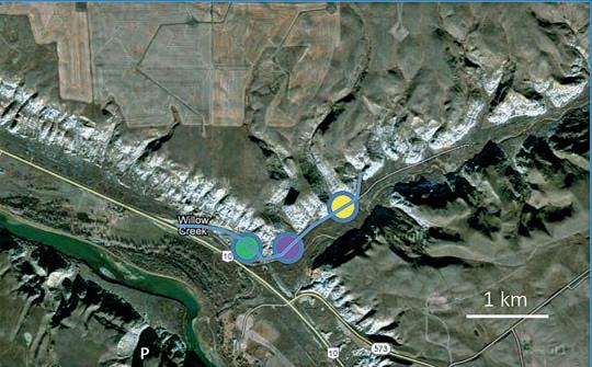
The Reservoir Committee welcomes contributions from our readership to this series. If you wish to offer a submission to Go Take a Hike on your favourite hike of geological interest, email the Reservoir at Emma.MacPherson@cspg.org for more information.
Centre Left: Stacked estuarine channels composed of Inclined Heterolithic Strata (IHS). Sideritic muddy beds separate the individual stacked estuarine channels. IHS are gently dipping interbeds of coarse and fine clastics deposited by a migrating point bar in a channel (Thomas et al, 1987). At Willow Creek the deposits are tidally influenced and contain thin muds and tidal bundles. Bottom Left: large rip-up casts up to 1m in length near the base of a channel fill. Pen for scale indicated by arrow. The clasts were ductile at the time of their creation and some exhibit folding and compression.
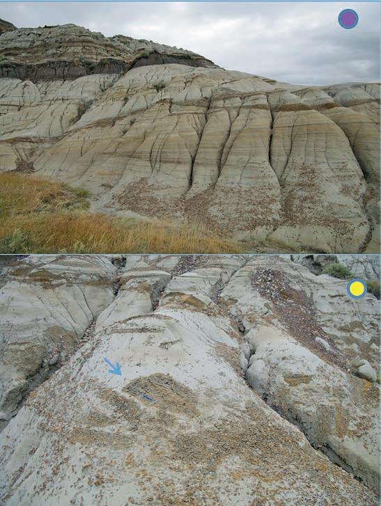
Trailhead: Drive 16 km southeast of Drumheller on Hoodoo Trail (Hwy 10 to parking lot.
Distance: It is a very short stroll around the hoodoos (please stay on proscribed path to avoid damage to these unusual features. You can drive or walk for several kilometres up Willow Creek to observe the well exposed strata in 3 dimensions. Elevation gain is minimal to 100m depending on how far you ascend. Up Willow Creek you have more freedom to explore the slopes. The sediment can be very slippery when wet and there can be crevices in the gullies, take care.
During much of the late Cretaceous a shallow ocean, the Western Interior Seaway, stretched from Gulf of Mexico to the Arctic Ocean. The Bearpaw Formation is the marine shale deposited when the ocean was at one of its widest extents. With the resumption of the Laramide Orogeny (uplift of the Rockies) in the late Campanian and Maastrichtian the vast sea began to retreat. This is reflected in deposition of the overlying marginal marine and terrestrial strata of the Horseshoe Canyon Formation (Khc). The contact between the Bearpaw (Kbp) and the Khc may be sharp (as it is here) or gradational. The contact between the formations is also diachronous and is younger to the east, due to a marching shoreline driven by the growing Rockies. Dinosaur remains are abundant in the Khc but the relatively rarity of turtle and crocodile remains suggests a trend towards a cooler climate.
Willow Creek has an exceptional 3D exposure of estuarine deposits. An estuary is the portion of a river valley that is influenced by marine processes (including tides and varying salinity). The estuarine channels are largely filled by inclined heterolithic strata (IHS). Stacked channels can be distinguished by truncated beds, rip up clast lags and (if preserved) finer sediments at the channel tops. When river transported fines enter an estuary they encounter increased salinities. Clays will then cluster or flocculate and they drop out of the water column. Fluctuations in salinity will thus cause cyclical deposits of muds in the estuarine system. Where this is due to tides one can get very thin rhythmic deposits of sand and mud called tidal couplets. Fine grained plant debris has different hydrodynamic and density properties and, where abundant, adds a third layer to the cycle. This is well displayed at Willow Creek in fresh outcrop exposures.
The Khc transition upwards to a terrestrial setting is marked by the presence of coals (within an interval known as the Drumheller Coal Zone) and, in places, massive petrified tree stumps. The coals were exploited in the early days by miners and numerous abandoned mines dot the valley. More recently the coal has gained value as a source of coal bed methane or CBM. Nearby wells chase the CBM play to depths up to 1000m at which point overburden pressure closes cleats and hinders economic production. Fifteen major coal seams are identified in the Red Deer Valley, the lowest ( Coals 0 to 3) are observed here. The top of Coal 0 contains a Glossifungites and Teredolites (created by a marine wood boring bivalve) burrowed surface. This is overlain by transgressive marine strata; either oyster (Ostrea glabra) bearing mudstones or sandstone with coal rip-up clasts and knobby sideritized Ophiomorpha burrows. If you continue up through the succession exposed at the parking lot you will pass through successive cycles of marginally marine and terrestrial strata reflecting the mobile shoreline due to an interplay of sediment compaction, local tectonics, and global sea level rise and fall. Look for coals, rooted horizons and petrified tree trunks as evidence of terrestrial setting. The sands are primarily estuarine or upper shoreface (with swaley cross stratification and macaroni-shaped Macaronichnus burrows).
If you are thirsty after your excursion I recommend visiting the Last Chance Saloon and Inn in Wayne (Hwy 10X north of the hoodoos). The inn, with a bar full of frontier character, was constructed in 1911 to serve local coal miners. It became known as the “bucket of blood” for their rowdy ways.
References: Ainsworth, Bruce., 1992. Sedimentology and Sequence Stratigraphy of the Upper Cretaceous, Bearpaw-Horseshoe Canyon Transition, Drumheller, Alberta. A Field Guide. AAPG Annual Convention, 1992.
Eberth, David A., Braman, Dennis R., 2012. A revised stratigraphy and depositional history for the Horseshoe Canyon Formation (Upper Cretaceous), southern Alberta plains. Canadian Journal of Earth Sciences, 2012, 49(9): 1053-1086, 10.1139/e2012-035
Langenburg, W., Beaton, A. And Eberth D., 2006. Edmonton Geology Society Drumheller Field Trip Guide. http://www.egs.ab.ca/Resources/EGS%20Fieldtrips/114-%20Drumheller_2006_EGS.pdf
Thomas, R.G., Smith, D.G., Wood, J.M., Visser, J., Calverley-Range, E.A., Koster, E.H., 1987. Inclined heterolithic stratification—Terminology, description, interpretation and significance. Sedimentary Geology, Vol 53, Issues 1-2, p 123-179.
Vakarelov, Boyan K., Ainsworth R. B, MacEachern, J.A., 2012. Recognition of wave-dominated, tide-influenced shoreline systems in the rock record: Variations from a microtidal shoreline model. Sedimentary Geology 279 (2012) 23–41.
28 RESERVOIR ISSUE 05 • MAY 2014
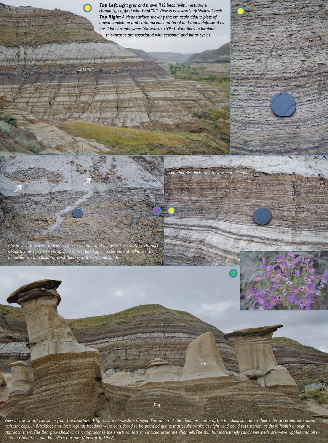
RESERVOIR ISSUE 05 • MAY 2014 29
2013 STANLEY SLIPPER GOLD MEDAL
The Stanley Slipper Gold Medal is the CSPG’s most prestigious award. It was established in 1989 to honour individuals who have made outstanding contributions to the science of petroleum geology and to petroleum exploration in Canada. The award is named after Stanley E. Slipper, the founding President of the Alberta Society of Petroleum Geologists which became the Canadian Society of Petroleum Geologists in 1973. Stanley Slipper is one of the iconic early explorationists in Western Canada.
Recipients of this award have made contributions encompassing one or more activities related to petroleum exploration and development. Such activities may include: initiating and leading exploration programs, teaching and mentoring, developing innovative exploration concepts, and including demonstrated leadership within geological societies and professional organizations.
The recipient of the 2013 Stanley Slipper Gold Medal is Robert Marc Bustin
Marc began his geological career in Alberta where he attended the University of Calgary where he was awarded his BSc in 1975 and his MSc in 1977. He then migrated west and obtained his doctorate at the University of British Columbia in 1980. Marc made Vancouver his home base and is currently Professor of petroleum and coal geology in the Department of Earth and Ocean Sciences at the University of British Columbia. He is also President of RMB Earth Science Consultants and the former President of CBM Solutions Ltd. Dr. Bustin is a registered Professional Geoscientist in the province of British Columbia.
His professional experience includes employment by Mobil Oil Canada and by Gulf Canada Resources prior to joining academia and subsequently has spent time with ElfAquitaine (France), CSIRO (France) and CNRS (Australia). Dr. Bustin has consulted in the area of fossil fuel resource evaluation and functioned as director and technical advisor for a variety of small through large petroleum companies in Europe, Africa, North America and Asia.
Marc has over thirty years experience in unconventional gas exploration and exploitation in industry, research and consultancy. He has designed and managed gas shale and coalbed methane evaluation and development projects worldwide, including China, Botswana, Eastern and Western Europe, Australia, SE Asia, India and basins throughout North America.
Marc has published over 180 reviewed scientific articles on fossil fuels. He is or has been an associate editor of the Bulletin of Canadian Petroleum Geology, Sedimentary Geology, International Journal of Coal Geology and the Canadian Journal of Earth Sciences. He is a member of the Royal Society, AAPG, TSOP and CSPG and is an elected Fellow of the Royal Society of Canada. His past awards include the A. L. Leverson memorial award from the AAPG, the Thiesson Medal from the International Committee for Coal Petrography for his contributions to coal sciences/ organic petrology, the Sproule Award for contributions to the study of unconventional gas resources and the Gilbert H. Cady Award from the Geological Society of America for his contributions to coal science and corecipient of the Medal of Merit from the Canadian Society of Petroleum Geology.
Dr. Bustin is best known for his research on unconventional hydrocarbon systems and his accomplishments in that field have been pivotal in the successful pursuit of numerous plays in Western Canada and elsewhere. Support for his research has been broadly based and includes numerous companies, government agencies and regulatory bodies. Marc combines several attributes of a seasoned explorer in his generation of innovative ideas and their systematic pursuit. His contributions have been through his own accomplishments and through the work of his numerous undergraduate and graduate students who now populate our industry. He attributes much of what he has done to his many great graduate students and all of the others he has worked with over the years
RESERVOIR ISSUE 05 • MAY 2014 31
SAVE THE DATE for the CSPG Mixed Golf Tournament August 22nd, 2014
2013 H.M. HUNTER AWARD
The H.M. Hunter award is awarded annually to CSPG members who have provided long-term service to the Society. The 2013 recipient is Benjamin J. McKenzie.
Ben has been a CSPG member since 1982 and has served the Society in numerous capacities. He began a more active role in 1992 by compiling and arranging to publish, through the CSPG, a series of detailed correlation charts for Alberta. In 1993, in response to one of the industry’s downturns, he joined with a group of fellow members and made use of his database and publication knowledge to produce a consultant directory as a way to advertise members’ expertise. In the mid-90s to mid-2000s, he worked with the Canadian Gas Potential Committee (which began as a CSPG committee) in a variety of roles on each of their three reports.
Ben came into his own in 2003 when he took over as the Technical Editor of the Reservoir magazine. At the time there was serious talk about cutting back and moving to a digital-only format for the Reservoir in order to reduce costs.

However, Ben’s dedication to the task in editing, coordinating publication efforts and volunteers, and contributing numerous technical articles helped prevent this. Under his guidance the Reservoir flourished to become the pre-eminent method by which the CSPG communicates with its members.
In 2009 Ben also took on the position of Committee Chair for the Digital Atlas Committee. Working closely with ESRI and other committee members, Ben developed a ‘proof of concept’ web-based geological atlas. A demonstration of this product was presented during the GeoCanada 2010 convention.
Although retiring from his position as Technical Editor of the Reservoir in March 2013, Ben remains active with the CSPG, most recently giving two presentations in the Geocafe´ Learning Series.
The Society could not have found a more suitable candidate to receive the H.M. Hunter Award for 2013 than Ben McKenzie for his outstanding long-term service.
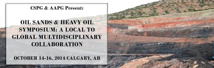
32 RESERVOIR ISSUE 05 • MAY 2014
International Prospects Large Scale Deposits Medium/Small-Scale Reservoirs New Drilling & Completions Cap Rocks & Reservoir Integrity Regulatory Issues & Sustainability Topics Include: REGISTER ONLINE at www.cspg.org/conferences Conference Presented By:
2013 TRACKS AWARD
The CSPG Tracks Award is presented annually to a CSPG Member who has made outstanding contributions to the Society. It is designed to recognize individuals who have set new standards of excellence within the Society – those who have made “tracks” for others to follow. The 2013 Tracks Award recipient is Riona Freeman.
Riona has been a CSPG member since 1992. Upon moving to Calgary in 2004 she sought out an opportunity to volunteer with CSPG, recognizing its value within the Calgary geoscience community and beyond while wanting to give back to the organization that she had been a member of since her graduate school days. Shortly thereafter, she was invited by Tony Cadrin who was chairing the Technical Luncheon Committee at the time, to join his group and she has been with the committee ever since. Every year Riona works with the other co-chairs and CSPG staff to plan and execute 17 to 19 luncheons that see speakers coming from across North America and around the world.
The success of the luncheons and quality of speakers has steadily risen because of her involvement.
Riona has also been a member of the Indexing Committee for a number of years. For her it is great motivation to
read CSPG publications and be rewarded with the opportunity to meet with Peter Hayes and his merry gang of rogues that is the Publications Index committee.
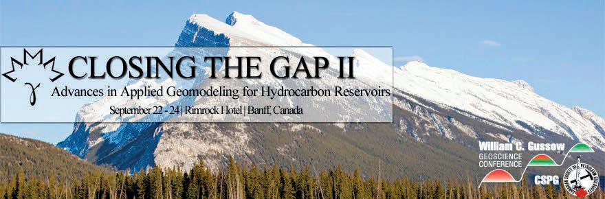
RESERVOIR ISSUE 05 • MAY 2014 33 REGISTRATION NOW OPEN JOIN US AT THIS YEAR’S GUSSOW CONFERENCE - SEPTEMBER 22 - 24 EARLY BIRD REGISTRATION DEADLINE: June 27th, 2014 Visit www.cspg.org/conferences for more information and to register today
GEOCONVENTION 2014: FOCUS
FOCUS ON MOBILE APP
As I write this article, GeoConvention is just over a month away. If you are like me you are starting to review the technical sessions and events and plan your convention. The new and improved Mobile App is available and proving a great way to do planning and more! Here’s the top 5 things you need to know to get the most out of the Mobile App:
1. Where do I get the Mobile App? It’s available at iTunes and Google Play. Search for GeoConvention 2014. Download it onto your smartphone or tablet today!
2. How do I get started using the Mobile App? When you first open the app you’ll see a Splash Screen for our Mobile App and Diamond convention sponsor, GeoLogic Systems. Once the second screen comes up, click on the Focus icon. (In future years there will also be more icons, but for now it’s just 2014.) Now you will see the main navigation screen where you can select things like Exhibitors, Sponsors and the all-important Schedule! Swipe to the left for additional icons including FAQ!
3. How do I plan my Convention?
The app has a lot of great features for planning. Here’s a few essentials:
a. Schedule –View by Day, Topic, Speaker or, as you bookmark events, by Bookmarked Activities.
b. Exhibitors – All Exhibitors will be listed by Name and Category. Click on a specific Exhibitor to see a description as well as booth number and website. Click on the booth number to show their location on the Exhibit floor map!
c. Maps –Interactive maps are available for the Convention Centre so you can find your talks; for the Exhibit floor so you can meet with Exhibitors and Sponsors; and for Calgary downtown so you can find a place to meet for lunch!
4. How do I use the App during the Convention? There are lots of cool ways to use the app during the convention. Here’s just a few you might NOT expect:
a. Judging – Rate each talk between 1 and 5 stars. You’ll find this on the page for each specific talk.
b. Notes – For each talk you can take notes on your device. You can make notes on the Exhibitors’ pages, too!
c. Social Media – Follow #geocon14 on Twitter or join the group on LinkedIn. Stay connected to what’s trending at the Conference and share in discussions.
5. How do I get help using the Mobile App? Having trouble navigating through the app? Prior to the convention, email me at nlaing@canadiandiscovery.com. I will do my best to respond within
24 hours. At the convention, look for volunteers with the ‘Ask Me’ t-shirts.
TWO FINAL NOTES:
1. Don’t be afraid to try things! Push buttons, touch maps – check it out. It is highly unlikely you can break anything so CLICK AWAY!!
2. Have patience! As this is the first year we are using this Mobile App there are sure to be bumps. Let’s celebrate what is working, fun and effective to use. And please let me know what isn’t workingif we can’t fix it this year, we’ll work on improvements for next year.
I hope you enjoy using the Mobile App to get the most of GeoConvention 2014. See you there!
Nancy Laing Mobile App Committee Chair
34 RESERVOIR ISSUE 05 • MAY 2014
May
www.geoconvention.com
12 – 16, 2014,
THANK YOU Ali Beken for Your Volunteer Service since 2010!
ROCK SHOP
2014 CANADIAN PLAYMAKER FORUM
| Organized by the Canadian Society of Petroleum Geologists, American Association of Petroleum Geologists, and the AAPG Division of Professional Affairs
Produced by Geoscientists for Geoscientists, the inaugural CSPG the Playmaker Forum will be held on Tuesday May 27th, at the Martha Cohen Theatre in Calgary, Alberta. The forum will bring well-known, successful, and distinguished speakers together for a day of unparalleled discussion on a cross-section of elements that will include the art of exploration, engineering technologies, exploration and strategies, and an overview of resource assessments.
The intent of this one-day forum is to provide a perspective on technical and business skills that are required by geoscientists today to successfully mature prospects from first insight through, play entry, technical assessment, promoting, marketing, and discovery. The forum provides a group of speakers, who are experts and experienced playmakers and will assist geoscientists, land men, engineers, and explorers in gaining an improved understanding of scientific and commercial requirements for successful prospect generation; provide the delegates with an improved ability to interaction with
the public and landholders; and greater insight into ensuring the highest degree of professionalism and ethics in their professional activities.
Among the thirteen invited speakers will be Dr. Dale Leckie, CSPG President, will present a talk on the “Public Perception and Reality of Environment Risks Associated with Gas and Oil Exploration Fracking, a Case Study” and Dr. Lee Krystinik, AAPG President, who will speak on “Pushing Hubert’s Curve – The Impact of Unconventional Resources Revolution for North America and the World.” Another very interesting talk will be on “Exploration Creativity”, by past AAPG President Ted Beaumont, and Bill Haskett, with present a talk titled “Unconventional Thinking in Resource Assessments”. A number of speakers will also provide discovery histories of plays such as the Groundbirch Montney, the Second White Specs, and the Flemish Pass Basin, offshore Newfoundland and Labrador and we will have a technology talk from Dr. Nathan Meehan titled “The hard part lies ahead of us: Thoughts on the future of resource technologies.”
The highlight of our day-long forum will be our luncheon talk that will feature our distinguished invited speaker Mr. Clay Riddell, Member of the Order of Canada, CSPG Past President, Stanley Slipper Award Recipient and CEO of Paramount Resources who will discuss his long and distinguished career with the delegates and answer questions after the luncheon talk.
This inaugural event is limited to the first 250 applicants. Attendees will be provided with lunch, a post-forum reception and access to the speakers throughout the day.
Register today before the attendee limit is reached. Please contact the CSPG office and visit the CSPG website for full details and registration.
John Hogg, Chair 2014 Canadian Playmaker

RESERVOIR ISSUE 05 • MAY 2014 35
BRINGING THE CRETACEOUS SEA TO MOUNT ROYAL UNIVERSITY: A Proposal to Fund the East Gate Entrance Fossil Display
WHY BRING THE CRETACEOUS SEA TO MOUNT ROYAL UNIVERSITY
The display of Cretaceous Sea fossils at Mount Royal’s East Gate entrance will provide both students and the general public the opportunity to view life size specimens of extinct marine vertebrate animals that swam in the Cretaceous Seas of western North America. Students and visitors will be able to discern the various types of marine reptiles and fish and the variations in skeletal arrangements and relationships they have with each other.
The East Gate entrance is the primary entry into the main building on campus. Most visitors coming to the University use this entrance, while countless students, faculty and staff traverse this space daily going to classes or to access the bookstore, food services, the library and most administrative offices. The fossil display will be viewed daily by thousands of people.
WHAT WOULD THE CRETACEOUS SEA FOSSIL DISPLAY LOOK LIKE?
The dominant feature of the display will be the large Plesiosaur (Elasmosaurus sp.) which will be suspended at the height of the second level which will allow the upper portion of the specimen to be viewed from the second level balcony while the underside will be easily viewed from ground level.
A small fish (Euchodus sp.) will serve as the prey of the Plesiosaur and will be mounted several metres away from the jaws of Elasmosaurus on the east wall. Watching the action will be a pterodactyl (Pteranodon sp.) suspended from the ceiling. In addition, a large fish Pachyrhizodus sp.and a small turtle (Protostega) will be mounted on the west wall in the entrance.
At a later date, a male Pteranodon or a large mural illustrating a typical Cretaceous Sea, and Cretaceous marine invertebrates will be added.
Collectively, the specimens will be arranged to show the relationships between these species at that time.
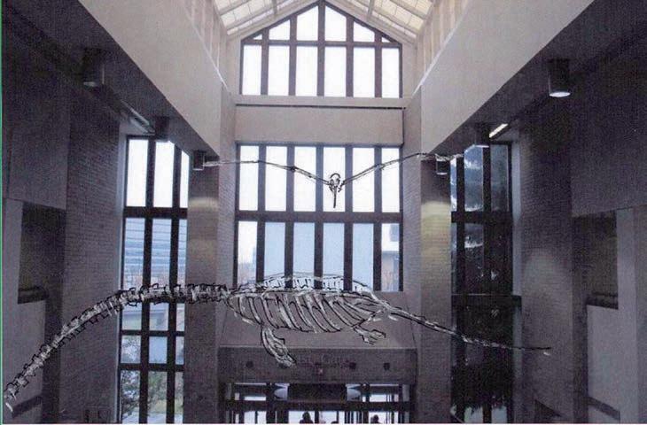
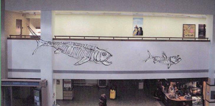
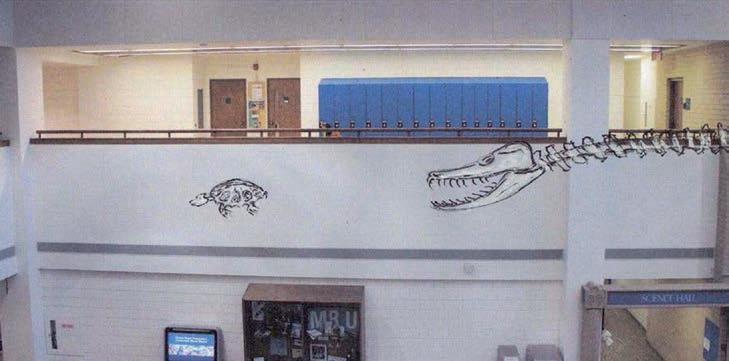
36 RESERVOIR ISSUE 05 • MAY 2014
Image 1: East gate entrance to Mount Royal University’s main building.
Image 2: West side of the East Gate entrance atrium.
Image 3: East side of the East Gate entrance atrium.
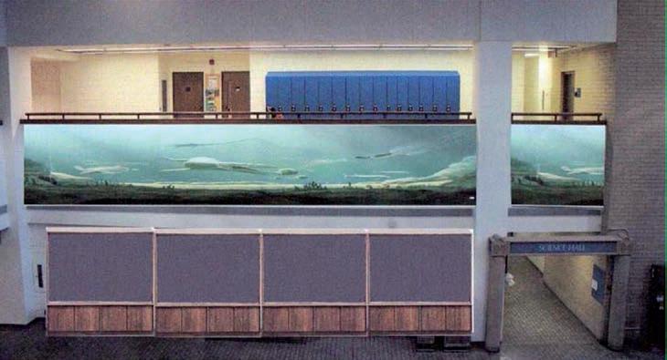
Phase 1
• large Plesiosaur (Elasmosaurus)
• small fish (Euchodus sp)
• Pteranodon Pachyrhizodus
Phase 2
• fish (Xiphactinus)
Phase 3
• Large male Pteranodon and/or a large Mural illustrating a typical Cretaceous Sea.
Phase 4
• Cretaceous Marine Invertebrates placed in display cases; and other illustrative materials.
PHASES 1 AND 2: FIVE CRETACEOUS MARINE REPTILES AND FISH
The most striking pieces of the Cretaceous marine vertebrate display are the five mounted life size specimens suspended from the ceiling of the atrium at the east gate entrance. The five specimens represent a diverse vertebrate fauna that would have been found in the Cretaceous Sea in western North America. The life size specimen will be arranged in a pattern in which they may have occurred. The various arrangements of the specimen are designed to represent prey being pursued by a predator.
PHASES 3 AND 4: MURAL ON EAST WALL AND DISPLAY CABINETS FOR CRETACEOUS INVERTEBRATE FOSSILS
The mural on the east wall of the atrium, depicting the environment in which the vertebrates and invertebrates existed during Cretaceous times in western North America, will serve as a transition between the marine vertebrate skeletons mounted
in the atrium and the marine invertebrate fossil specimens displayed below.
The marine invertebrate display will be positioned on the ground floor and will contain actual specimens of typical Cretaceous marine invertebrate fauna. To best display the invertebrate fossils, several display cases will be custom built.
Installation
Mount Royal University staff, in consultation with Triebold Paleontology, Inc. and consultant engineers, will install the vertebrate fossil specimens, attaching
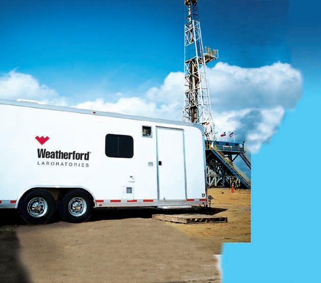
(Continued on page 38 ...)
When time is money, Wellsite Geoscience is money well spent.
Whether you’re exploring a basin, producing a well or completing a shale play, time is money. That’s why Weatherford Laboratories brings a suite of formation evaluation technologies right to the wellsite. Utilizing mud gas and cuttings, these technologies provide detailed data on gas composition, organic richness, mineralogy and chemostratigraphy in near real time. As a result, operators now have an invaluable tool to assist with sweet spot identification, wellbore positioning, completion design and hydraulic fracturing. We call it Science At the Wellsite. You’ll call it money well spent.
SCIENCE AT THE WELLSITE ™
www.weatherfordlabs.com
RESERVOIR ISSUE 05 • MAY 2014 37
©2013 Weatherford. All rights reserved Formation Evaluation ┃Well Construction ┃Completion ┃Production
WELLSITE GEOSCIENCE SERVICES
Image 4: Mural and display cases at East side of the East Gate entrance atrium.
CORPORATE SUPPORTERS
Cougar Consultants, Inc.
RIGSAT
Total
Advanced
Enviro-Tech
EV
Serpa
RPS
Exova
GranTierra
Pason
Pulse
Shea
Core
Compass
Sproule International
BDO
Maxam
Trident
Sourcex Regent
Bankers
BJV
(...Continued from page 37)
them to special structures in the upper portions of the atrium and suspending them at the approximate height of the second level. The full length mural depicting the life forms of the Cretaceous Sea, as it is interpreted for Western North America, will be painted on the East wall of the atrium. Typical marine invertebrate fossils will be displayed on the ground level along the East wall in well lit, custom built display cases.
Funding
The goal of the project is to initially raise $100,000 through private and corporate donations to fund Phase 1 of the display. Additional funds will be required to add Phases 2, 3 and 4. Total cost of the project is estimated at $200,000.
Currently, an anonymous donor has agreed to match donations up to $50,000 for Phase 1. Additional funding has been obtained from APEGA to complete Phases 1 and 2. We are now seeking funding for Phases 3 and 4 which will complete the display.
Triebold Paleontology, Inc. Dr. Michael Triebold, President
Contacts
• Dr. Wayne Haglund, Prof. Emeritus, Department of Earth Sciences, Mount Royal University Phone: 403.440.7238
• Dr. Paul Johnston, Chair, Department of Earth Sciences, Mount Royal University
• Dr. Jeff Goldberg, Dean, Science and Technology, Mount Royal University
• Pamella Simpson, Senior Development Officer, Mount Royal University Foundation Phone: 403.440.7725
CSPG Membership Drive
Communications
Gas
Detection Ltd.
Apache Canada Ltd.
Flow Technologies
Surveys Ltd.
Cam Canada Inc.
Petroleum Consulting Ltd.
Energy Canada Ltd.
Canada Brokerlink Inc.
Energy Navigator
Canada Inc.
Energy Inc.
Sigma Explorations
System
Seismic Inc.
Nerland Calnan LLP
Laboratories
Cabra Consulting Ltd.
Directional Services
Trust
Crescent Point Energy
Fekete SAExploration
Limited
Edge Technologies Inc.
Canada LLP
Birchcliff Energy Ltd.
Cabra Enterprises Ltd.
Datalog Technology Inc.
Limited Geotir
Point Energy
Exploration Surveys
Solutions Inc.
GeoSpace Technologies Knowledge Reservoir Sproule Associates
Crescent
Glacier
Matrix
Associates Consultants Ltd.
Oilwell Varco
Ltd.
Inc.
Southern Exploration
Geoservices Ltd.
McDaniel &
National
Statcom
GeoChemTech
FMQ
Matrix
Seismic
Robertson Consulting Ltd.
Explosives Petrel
Exploration Corp.
Resources
Petroleum Ltd.
Exploration Partnership
Environmental Services
International
Royalties
Energy
Energy
European Petroleum Ltd.
Energy International
LeClerc
Associates
Wittstrom Serinus Energy Skyhawk Exploration
Exploration Ltd. AS OF APRIL 10, 2014 CSPG welcomes our 2013 Corporate Supporters! The benefits of being a corporate member include: • Recognition in the monthly Reservoir and quarterly Bulletin • One associate membership • Reserved tables at the technical luncheons with your company logo • One free pass to the CSPG Core Conference…and more! Contact Kasandra Klein at kasandra.klein@cspg.org to be a corporate member today! 38 RESERVOIR ISSUE 04 • MAY 2014
Nickpoint
SOCO
3e
Bengal
Bukit
Central
DualEx
Lorne
&
Martin
Tretio
Partnering Supplier
Refer a new member to CSPG and be entered into a draw for a trip for four to the Mt. Stephen Trilobite Beds! Details at www.cspg.org (under Members)
Warning: Our data has gone mobile
(You may never return to the office)

Now, get geoLOGIC’s value-added data almost any place, any time, any way you want it. Available through gDCweb on your tablet, smartphone or computer.
With 30 years of data experience behind it, gDC is the source for high quality, value-added well and land data from across Western Canada and the Northern United States. Another plus – our data is accessible through an expanding range of industry software utilizing our own easy-to-use gDC GIS and our geoSCOUT software.
View, search, import and export well, land and production data, documents, logs and more from almost anywhere. For more information visit our website at www.geoLOGIC.com
Leading the way with customer-driven data, integrated software and services for your upstream decision-making needs.
geoSCOUT | gDC | petroCUBE at www.geoLOGIC.com
