
$4.00 NOVEMBER 2016 VOLUME 43, ISSUE 10 Canadian Publication Mail Contract – 40070050 RETURN UNDELIVERABLE CANADIAN ADDRESSES TO: CSPG – 110, 333 - 5 Avenue SW Calgary, Alberta T2P 3B6
Message from the Board
Technical Luncheons 19 Ontario Oil and Gas: 3. Silurian and Devonian Conventional Plays 28 Quarterly Commodity Pricing Update
5
8

SPE/CSPG Introduction to Petroleum Engineering and Geosciences
SPE and CSPG have co-created a bootcamp style training course for anyone who wants to better understand petroleum focused engineering and geosciences.
This course introduces tools and techniques used by engineers and geologists to identify oil and gas plays. It describes how wells are drilled and explains how the production cycle is completed.
At the end of this course you will have a better understanding of these disciplines and how they integrate with the work you do. Day 1 and 2 focus on geosciences and day 3 and 4 cover basic petroleum engineering.

www.spe.org/training/courses/IPE.php
Registration Includes: 4 days of instruction by industry professionals, plus course materials
COURSE INSTRUCTORS
Roger Hough, P. Eng
Saad Ibrahim, P. Eng
Art Irwin, Msc. P. Geo
Jon Noad, P. Geo
Special Introductory Offer
4 Days: CAD 1000
2 Days - 1 Discipline: CAD 700 (geoscience or engineering)
Why Should You Attend:
To improve your industry knowledge and enhance job performance by learning how your contribution fits into the overall business process. You will also be able to communicate more effectively in the industry with respect to understanding how the engineering and geoscience disciplines fit together and the language that goes with it.
Who Should Attend:
Anyone working in the industry and dealing with engineers and geologists, use information from engineers or geologists ,or who are peripheral to the industry and need an overview of the whole process. Engineers, geologists, geoscientists, geophysicists, technical assistants, work-term students, accountants, legal and contracts, analysts, human resources personnel, economists, service company personnel, lease holders, regulatory staff.
REGISTER TODAY
CSPG OFFICE
#110, 333 – 5th Avenue SW
Calgary, Alberta, Canada T2P 3B6
Tel: 403-264-5610
Web: www.cspg.org
Please visit our website for all tickets sales and event/course registrations Office hours: Monday to Friday, 8:00am to 4:00pm
The CSPG Office is Closed the 1st and 3rd Friday of every month.
OFFICE CONTACTS
Membership Inquiries
Tel: 403-513-1234
Email: membership@cspg.org
Advertising Inquiries: Kristy Casebeer
Tel: 403-513-1233 Email: kristy.casebeer@cspg.org
Sponsorship Opportunities: Lis Bjeld
Tel: 403-513-1235
Email: lis.bjeld@cspg.org
Conference Inquiries: Lis Bjeld
Tel: 403-513-1235, Email: lis.bjeld@cspg.org
CSPG Foundation: Kasandra Amaro
Tel: 403-513-1234
Email: kasandra.amaro@cspg.org
Accounting Inquiries: Eric Tang
Tel: 403-513-1232
Email: eric.tang@cspg.org
Executive Director: Lis Bjeld
Tel: 403-513-1235, Email: lis.bjeld@cspg.org
EDITORS/AUTHORS
Jason Frank Co-Editor | jfrank@atha.com
Travis Hobbs, Co-Editor | travis.hobbs@encana.com
Please submit RESERVOIR articles to the CSPG office. Submission deadline is the 23rd day of the month, two months prior to issue date. (e.g., January 23 for the March issue).
To publish an article, the CSPG requires digital copies of the document. Text should be in Microsoft Word format and illustrations should be in TIFF format at 300 dpi., at final size.
CSPG COORDINATING EDITOR
Emma MacPherson, Communications Coordinator
Canadian Society of Petroleum Geologists
Tel: 403-513-1230, emma.macpherson@cspg.org
The RESERVOIR is published 11 times per year by the Canadian Society of Petroleum Geologists. This includes a combined issue for the months of July and August. The purpose of the RESERVOIR is to publicize the Society’s many activities and to promote the geosciences. We look for both technical and non-technical material to publish. The contents of this publication may not be reproduced either in part or in full without the consent of the publisher. Additional copies of the RESERVOIR are available at the CSPG office.
No official endorsement or sponsorship by the CSPG is implied for any advertisement, insert, or article that appears in the Reservoir unless otherwise noted. All submitted materials are reviewed by the editor. We reserve the right to edit all submissions, including letters to the Editor. Submissions must include your name, address, and membership number (if applicable).The material contained in this publication is intended for informational use only.
While reasonable care has been taken, authors and the CSPG make no guarantees that any of the equations, schematics, or devices discussed will perform as expected or that they will give the desired results. Some information contained herein may be inaccurate or may vary from standard measurements. The CSPG expressly disclaims any and all liability for the acts, omissions, or conduct of any third-party user of information contained in this publication. Under no circumstances shall the CSPG and its officers,
employees, and agents be liable for any injury, loss, damage, or
arising in any manner whatsoever from the acts, omissions, or conduct of any third-party user.
Printed by McAra Printing, Calgary, Alberta. FRONT COVER Eastern Front Ranges, Kananaskis, Alberta. Near-vertically tilted strata of Devonian to Mississippian aged strata form a long series of peaks and ridges from Old Baldy Mountain (viewpoint, looking NNW) to Wasootch Ridge and Mount Lorette. Cornelius Rott NOVEMBER 2016 – VOLUME 43, ISSUE 10 ARTICLES Ontario Oil and Gas: 3. Silurian and Devonian Conventional Plays 19 Quarterly Commodity Pricing Update ....................................................................... 28 CSPG Mixed Golf Tournament 29 From the Archives ....................................................................................................... 30 DEPARTMENTS Message from the Board 5 Rock Shop ...................................................................................................................... 7 Technical Luncheons ................................................................................................... 8 Division Talks 11 RESERVOIR ISSUE 10 • NOVEMBER 2016 3
directors,
expense
knowledge IS POWER.
Francis Bacon

Power your upstream decision-making with customer-driven data, integrated software and services from geoLOGIC.
At geoLOGIC, we help turn raw data into actionable knowledge. That’s a powerful tool to leverage all your decision making, whether it’s at head office or out in the field. From comprehensive oil and gas data to mapping and analysis, we’ve got you covered. Get all the knowledge you need, all in one place with geoLOGIC.
For more on our full suite of decision support tools, visit geoLOGIC.com
gDC Upstream knowledge solutions
geoSCOUT |
CSPG BOARD

PRESIDENT
Greg Lynch • Shell Canada Ltd. president@cspg.org Tel: 403.384.7704

PRESIDENT ELECT
Mark Cooper • Sherwood Geoconsulting Ltd. presidentelect@cspg.org

PAST PRESIDENT
Tony Cadrin pastpresident@cspg.org

FINANCE DIRECTOR
Scott Leroux directorfinance@cspg.org

FINANCE DIRECTOR ELECT
Shelley Leggitt • NAL Resources Ltd. directorfinanceelect@cspg.org

DIRECTOR
Mark Caplan conferences@cspg.org

DIRECTOR
Jen Russel-Houston • Osum Oil Sands Corp. Jrussel-houston@osumcorp.com Tel: 403.270.4768

DIRECTOR
Eric Street • Jupiter Resources estreet@jupiterresources.com Tel: 587.747.2631

DIRECTOR
John Cody • Statoil Canada Ltd. industryrelations@cspg.org

DIRECTOR
Ryan Lemiski ypg@cspg.org

EXECUTIVE DIRECTOR
Lis Bjeld • CSPG lis.bjeld@cspg.org Tel: 403.513.1235
MESSAGE FROM CSPG FOUNDATION BOARD
By Brett Norris
The CSPG Foundation is the charitable arm of the CSPG that was established in 1978 by some visionary CSPG members during the CSPG’s 50th anniversary, originally conceived to endow an income to finance aspects of the CSPG Outreach Program, particularly the Student Industry Field Trip (SIFT). The CSPG Foundation is charged with developing and stewarding donations to “fund programs that inspire and advance education, foster technical excellence and encourage awareness of petroleum geoscience” (CSPG Foundation Mission Statement). The CSPG Foundation is an independent organization, separate and distinct from the CSPG, complete with a separate board of trustees and deed. This arrangement is necessary to maintain the charitable designation of the CSPG Foundation. The CSPG Foundation is the charitable arm of the CSPG, and represents you, more than 3,000 CSPG members.
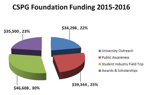
The Foundation is fully occupied with our core business of funding outreach initiatives that the members find worthwhile and that are consistent with the vision of the CSPG and CSPG Foundation. These outreach activities cover a broad scope, from grade school student and teacher awareness and education right through to university undergraduate and graduate student and thesis awards. Funding these outreach activities is even more important during these challenging times due to a sustained low oil price environment.
During the previous fiscal year (ending August 31, 2016), the CSPG Foundation awarded approximately $155,750 to various educational and outreach requests. This high level of funding is consistent with charitable outreach in the previous fiscal year, and is a significant and deliberate increase in spending from historic levels. Universityaffiliated recipients received the majority of the funding, roughly 75% of the total. The programs that receive funding include the
Student Industry Field Trip (SIFT), bursaries, scholarships, field study grants, donations to Canadian universities, and grants to external organizations engaged in geoscience outreach. Not all requests are funded. The criteria for funding requests have changed through time. If the requests do not meet our mandate, or if available funding is limited for the fiscal year, some requests may not be granted. Criteria for funding can be found on the CSPG Foundation website (www.cspg. org/foundation).
With this increase in outreach funding, the endowment is being reduced slowly over time, which means that there will be less funding available in the future unless the difference is made up by increased donations. The CSPG Foundation must balance requests for funding with sustainability of the endowment. Sustainability really means continued and increasing donations from CSPG members, the CSPG and other corporations.
As a member of the CSPG, this is your Foundation, and it exists to ensure that your donated funds are managed effectively and distributed according to the needs and wishes of you, the donors and CSPG members. Our board currently consists of eight trustees. Typically, many of the trustees are former directors or executive of the CSPG, which provides a coherency that best serves the CSPG members. The current board includes newcomers David Clyde, Tony Cadrin, and Keith Yaxley, in addition to longerstanding Trustees Tom Sneddon, Kathleen Shannon LL.B, P.Eng., Jassie Kang, CA, CPA (Treasurer), Kirk Osadetz (Secretary), and myself, Brett Norris (Chairman). The trustees have continued to work hard this past year on governance, our role and financial metrics as a charity, our transparency to donors, progressing our strategic plan to fund all CSPG outreach activities, as well as continuing to round out the skills and experience on the board. More information about the CSPG
(Continued on page 6...)
RESERVOIR ISSUE 10 • NOVEMBER 2016 5 MESSAGE FROM THE BOARD
CORPORATE SPONSORS
SAMARIUM
CSPG Foundation
DIAMOND
Alberta Energy Regulator
TITANIUM
AGAT Laboratories
geoLOGIC systems ltd.
Tourmaline Oil Corp.
PLATINUM
Univeristy of Calgary
Weatherford Canada Partnership
GOLD
Imperial Oil Resources
Loring Tarcore Labs Ltd.
Progress Energy Ltd.
SILVER
Chinook Consulting
Core Laboratories
MEG Energy Corp.
Repsol Oil and Gas Canada Inc.
Shell Canada Energy
BRONZE
Belloy Petroleum Consulting
Canada Brokerlink Inc.
CMC Research Institutes, Inc.
CSEG Foundation
Geomodeling Technology Corp.
Husky Energy Inc.
MJ Systems
Murphy Oil Company Ltd.
Nexen ULC
Schlumberger Canada Ltd.
Seitel Canada Ltd.
Tony Cadrin
Tuya Terra Geo Corp.
Foundation, the trustees, the programs that are funded, applying for grants, and making donations can be found on the CSPG website (www.cspg.org/foundation).
The trustees and the many beneficiaries of the Foundation funding would like to thank the CSPG members for your donations this past year. The environment within the industry makes this a particularly challenging time to give, yet many have stepped up when the need to fund outreach remains as important as ever. We thank you for your generosity and leadership in this regard.

We look forward to continuing to build our ability to achieve our goals, and by extension, the goals of the CSPG organization and its members. I would also like to take this opportunity to thank the current and recently retired trustees for their dedication and energy. It is a privilege to serve as the Chairman of such an excellent group, and to be part of the CSPG which in itself is a great and enduring organization.
As of August 31, 2016
The CSPG office is relocating to: 540, 5th Ave SW, Calgary, AB T2P 0M2 The move will be effective as of December 1st, 2016 RESERVOIR ISSUE 10 • NOVEMBER 2016 6 MESSAGE FROM THE BOARD


RESERVOIR ISSUE 10 • NOVEMBER 2016 7 Rock Shop Independant Wellsite Consultants Highly Skilled Competent Consultants Extensive Industry Experience (18 yrs +) Wellsite & Remote Supervision & Geosteering All Types of Conventional & Unconventional Wells Core, Chip Samples & Thin Section Studies International & Domestic Email: indwellcons5@gmail.com Tel: (403) 540-8496 1602 – 5th St N.E. Calgary, AB T2E 7W3 Phone: 403-233-7729 www.tihconsulting.com e-mail: tih@shaw.ca T.I.H. Consulting Ltd. Geologic Well-Site Supervision Advertise HERE! Contact us today! Email: Kristy.casebeer@cspg.org phone: 403.513.1233 Geological Consulting Services for 35 years Wellsight geological supervision and coring Geo-steering, Petrographic and Sample Studies Conventional & Heavy Plays | SAGD Projects Domestic and International Operations Moh & Associates Oilfield consultants Ltd. Since 1980 Moh Sahota, B.Sc (Hons), M.Sc. President Ph: 403.263.5440 Email: info@mohandassociates.com www.mohandassociates.com PETROGRAPHY AND THIN-SECTION ANALYSIS / X-RAY FLUORESCENCE - IN LAB AND PORTABLE / X-RAY DIFFRACTION / CORE & SAMPLE STUDIES / RESERVOIR CHARACTERIZATION LAB & ANALYTICS info@ProGeoConsultants.com ProGeoConsultants.com 403-262-9229
Imaging of Micro-and Nano-Scale Wettability & Fluid Distribution in Unconventional Light Oil Reservoirs
SPEAKER
Chris Clarkson | University of Calgary
11:45am
Wednesday, November 16th, 2016
Marriot Hotel | Kensington Ballroom Calgary, Alberta
Please note: The cut-off date for ticket sales is 1:00 pm, five business days before event. [Tuesday, November 08, 2016]. CSPG
Member Ticket Price: $39.50 + GST. NonMember Ticket Price: $47.50 + GST.
Each CSPG Technical Luncheon is 1 APEGA PDH credit. Tickets may be purchased online at www.cspg.org
ABSTRACT
Rock composition and pore structure in unconventional light oil (ULO) reservoirs is known to vary at the micro-/nano-scale, yet fluid-rock interaction is typically only characterized at the macro-scale. While micro-/nano-scale variations in wettability and fluid distribution are expected to have an impact on fluid flow controls such as capillary pressure and relative permeability, techniques for quantifying this variability have remained elusive.
In this study, micro-scale variability in wettability and fluid distribution in a tight oil reservoir (Middle Bakken, Viewfield Saskatchewan) is investigated using an FEI Quanta FEG 250 environmental field emission scanning electron microscope (E-FESEM). Three approaches were identified:
1. Condensation of water through careful control of sample temperature and water vapor pressure in the sample chamber of the microscope. An innovative approach for assessing water droplet contact angle at the micro-scale is then applied to evaluate wettability variation. This technique is only applicable to the evaluation of distilled water wettability.
2. Cryogenically freezing the samples, then imaging of static rock-fluid relationships in preserved core samples, or in samples that have been subjected to prior fluid injection experiments. This technique has shown promise for assessment of preserved core fluid distribution or for providing “snapshots” of fluid distribution during displacement experiments.
3. Selective injection of native or non-native fluids through a microinjection system, followed by imaging of rock-fluid interactions. This technique offers the greatest potential for selective fluid wettability experiments, including those involving hydraulic fracturing fluids for compatibility evaluation.
This study demonstrates that wettability heterogeneity in tight rock at the microscale can be significant, but may be quantified for use in pore-scale modeling of fluid flow using the E-FESEM.
BIOGRAPHY
Christopher R. Clarkson is a professor and the AITF Shell/Encana Chair in Unconventional Gas and Light Oil research in the Department of Geoscience and an adjunct professor with the Department of Chemical and Petroleum Engineering at the University of Calgary. His work focus in industry was on exploration for and development of unconventional gas (UG) and light oil (ULO) reservoirs. His research focus since coming to U of Calgary in 2009 has been on advanced reservoir characterization methods for UG-ULO, such as rate- and pressure-transient analysis,
flowback analysis, and core analysis. He is also interested in simulation of enhanced recovery processes in UG-ULO, and how these processes can be used to reduce greenhouse gas emissions. Clarkson leads an industry-sponsored consortium called “Tight Oil Consortium”, focused on these research topics for unconventional light oil reservoirs in Western Canada.
Clarkson holds a Ph.D. degree in geological engineering from the U. of British Columbia, Canada, and is the author of numerous articles in peer-reviewed scientific and engineering journals. Clarkson was an SPE Distinguished Lecturer for the 2009/2010 lecture season, and is the 2016 recipient of the Reservoir Description and Dynamics Award (Canadian Region) from the SPE.
Webcast Sponsored by
TECHNICAL LUNCHEON 8 RESERVOIR ISSUE 10 • NOVEMBER 2016
Chris Clarkson


2017 President Elect Nominees

Elections open on November 1st for the 2017 Presidentmembers November 1st. If you have not received your ballot call the CSPG Office
Full Biographies for both candidates are available online at www.cspg.org/vote

The results of the election will be announced at the Honorary Address Luncheon & geoLOGIC Holiday Social


Young Geoscientists Networking Reception

November 3rd, 2016
The Unicorn - 223, 8th Ave SW, Calgary, AB Time: 4:30 - 6:30
JON NOAD
CLINT TIPPETT
Free Registration for members $15 for non-members
Full Biographies for both candidates are available online at www.cspg.org/vote
Elections open on November 1st for the 2017 President-Elect. A ballot will be e mailed to all voting members November 1st. If you have not received your ballot call the CSPG Office
The results of the election will be announced at the Honorary Address Luncheon & geoLOGIC Holiday Social
RESERVOIR ISSUE 10 • NOVEMBER 2016 9
JON NOAD CLINT TIPPETT


Managing the Earthquakes Risk Associated with Oil & Gas Development and CO2 Sequestration
Mark D. Zoback | Professor of Geophysics Stanford University
DECEMBER
13TH | TELUS CONVENTION CENTRE
Member Price: 50.00
*Price Includes Holiday Social

Biography
Non-Member Price: 55.00
No state has experienced more seismicity associated with oil and gas activities than Oklahoma. We have shown that the increases in seismicity in Oklahoma are due to very large increases in the volume of produced water being injected into a deep saline aquifer laying immediately above crystalline basement. In this talk I will review the seismicity associated with oil and gas development in the central and eastern U.S., outline steps that can be taken to significantly reduce the risks associated with them.
Dr. Mark D. Zoback is the Benjamin M. Page Professor of Geophysics at Stanford University and Director of the Stanford Natural Gas Initiative. Dr. Zoback conducts research on in situ stress, fault mechanics, and reservoir geomechanics with an emphasis on shale gas, tight gas and tight oil production. He currently directs the Stanford Natural Gas Initiative and is co-director of the Stanford Center on Induced and Triggered Seismicity. He is the author of a textbook entitled Reservoir Geomechanics published in 2007 by Cambridge University Press and the author/coauthor of over 300 technical papers. Dr. Zoback was the founder of GeoMechanics Intl., a software and consulting company that was acquired by Baker Hughes in 2008.
***Full Biography available online
TECHNICAL LUNCHEON 10 RESERVOIR ISSUE 10 • NOVEMBER 2016


HYDROGEOLOGY
From Qumran to Kakuma: 25 Years of Geophysical Exploration from Dead Sea Scrolls to Water Supplies for Refugees
SPEAKER
Paul Bauman | Advisian Geophyscis
Time: 12:00 Noon
Date: Wednesday November 2, 2016
Suite 150, Acquitaine Tower, 2nd Floor, 540, 5th ave SW 12:00 noon
ABSTRACT
The use and applicability of near surface geophysical methods has evolved considerably over the last 30 years. Many techniques have applicability to the field
of hydrogeology. The presentation will highlight interesting and challenging projects that have been completed on 6 continents over the last 25 years. The highlighted projects will include exploring for Dead Sea Scroll Caves, the ancient City of Atlantis, the gas chambers of the Sobibor extermination camp, the Holocaust escape tunnel in Lithuania dug by the "Burning Brigade," water resources to alleviate drought and famine in Africa, and more than 30 ancient sites in the Middle East. Some of these projects have been covered in the popular media including National Geographic, Time Magazine, PBS Nova documentaries, Readers Digest, etc.
BIOGRAPHY
Mr. Paul Bauman, P.Eng., P.Geoph., is Technical Director, Advisian Geophysics. Since 1990, he has carried out near surface geophysical exploration programs on 6 continents. Mr. Bauman directs water exploration projects and teaches courses in hydrogeology and groundwater exploration to improve the quality of life in many Middle Eastern and African countries, including war-torn Yemen and famine-affected Malawi. In 2016, he received the APEGA Community Service Award for bringing his geophysical expertise to an international stage.
RESERVOIR ISSUE 10 • NOVEMBER 2016 11 DIVISION TALKS Join us prior to the Honorary Address Luncheon for the annual geoLOGIC Holiday Social Wine & Appetizers 10:30-11:30 Honorary Address Luncheon 11:30
1:00
-
DIVISION
BASS DIVISION
Depositional and Diagenetic History of the Mississippian Pekisko Formation, Hawk Hills Area, Northern Alberta: Controls on Sedimentation Patterns and Reservoir Development
SPEAKER
Lauren Eggie (University of Manitoba)
Time: 12:00 Noon Tuesday,
Date: November 8th, 2016
Location: Nexen Energy Annex
Horizon/Legacy Room, 8017th Avenue S.W., Calgary, Alberta, Canada, T2P 3P7
ABSTRACT
The Lower Mississippian (Tournaisian) Pekisko Formation of the Hawk Hills area of northern Alberta is 25 to 40 m thick, composed of massive skeletal-peloidal limestones with local shale beds, and hosts a large, medium to heavy-gravity oil resource that is presently being evaluated. The formation is interpreted to represent ramp development along the northern margin of the Peace River Embayment (PRE), an east-west oriented sub-basin of the pericratonic Prophet Trough that formed primarily through reactivation of a zone of pre-existing northeast-southwest trending basement faults. The Hawk Hills area also encompasses the Pekisko subcrop edge, formed by the development of the postMississippian unconformity.
The Pekisko Formation has been subdivided into four informal units: the lower carbonate, lower shaly, upper carbonate, and upper shaly. These units are composed of three lithofacies associations recognized on the basis of core descriptions and thin section analysis: (1) outer rampslope – characterized by argillaceous lime mudstones and crinoid wackestones; (2) outer ramp – consisting of crinoidbrachiopod wackestones and packstones; and (3) middle ramp – composed of peloidal-skeletal packstones to grainstones. These associations are stacked into metre to decametre-scale, shallowing and deepeningupward cycles. Detailed analysis of the facies
architecture has allowed for evaluation of the influence of the south-facing orientation of the Pekisko ramp, the basin configuration, and the overall transgressive conditions on depositional trends. It has also allowed for recognition of a change in ramp morphology from homoclinal to distally-steepened during lower shaly and upper carbonate unit deposition, due to higher rates of subsidence on the ramp adjacent to the PRE. This differential subsidence is tentatively interpreted to be due to intermittent movement on underlying basement faults.
The Pekisko Formation was significantly affected by diagenesis (marine, burial, and late meteoric). Marine diagenesis was characterized by significant micritization and microboring of allochems and limited radial-fibrous calcite cementation. Burial diagenesis was typified by neomorphism of matrix and allochems, dissolution of gastropods and other allochems, significant syntaxial and coarse mosaic calcite cementation, limited dolomitization, and minor quartz and gypsum cementation. Late meteoric diagenesis included dedolomitization and precipitation of chert and fluorite. Development of pervasive microvuggy porosity via partial dissolution of the matrix is interpreted to have occurred during late burial to meteoric diagenesis, during uplift of the section and subaerial exposure during the formation of the post-Mississippian unconformity. Porosity development is strongly texturally controlled, and is therefore primarily faciescontrolled.
Reservoir intervals in the Pekisko Formation in the study area are 0.1-13.1 m thick, dominantly composed of mid- to innerramp lithofacies, and typified by 10-20% microvuggy porosity and 0.1-30 mD permeability, with the highest porosities observed in packstones. The spatial distribution of the best reservoir for each informal Pekisko Formation subunit is
primarily controlled by basin morphology during deposition and timing of differential subsidence, as well as rates of relative sea level rise. Although there are development issues to be addressed, the Pekisko Formation in the Hawk Hills area is an excellent reservoir interval, with significant potential for future exploitation.
BIOGRAPHY
Lauren Eggie is a M.Sc. student in the Department of Geological Sciences at the University of Manitoba, currently completing her thesis on the Pekisko Formation of northern Alberta. She received her B.Sc. Honours Degree in Geological Sciences from the University of Manitoba in February 2013 and completed her Honours thesis on the Duperow Formation in May 2012. Lauren is the recipient of many scholarships and awards, including the Julie Payette-NSERC Research Scholarship, the Clayton H. Riddell Faculty of Environment, Earth, and Resources Gold Medal, and the Winthrop Spencer Gold Medal which is awarded by the University of Manitoba for outstanding achievement in geological research. She has given presentations on her Honours thesis at three national and regional conferences, and on her M.Sc. work at one national and two international conferences.
INFORMATION
BASS technical division talks are free. Please bring your lunch. For further information about our division, to join our mailing list, receive a list of upcoming talks, or if you wish to present a talk or lead a field trip, please contact either Steve Donaldson (BASS) at 403-808-8641, or Mark Caplan (BASS) at 403-975-7701, or visit our web page on the CSPG website at http:// www.cspg.org. The Nexen Energy Annex Horizon/Legacy Room can be found on the Plus +15 level, NW corner of 7th Ave and 7th St. SW, Calgary.
12 RESERVOIR ISSUE 10 • NOVEMBER 2016 DIVISION TALKS
STRUCTURAL DIVISION
Anticlinal and Synclinal Geometry and its Impact on the Reservoirs of the Zagros Foredeep in Kurdistan.
SPEAKER
Andrew C. Newson, P.Geol., Senior Technical Consultant, Moose Oils 2014 Ltd.
Time: 12:00 Noon Wednesday,
Date: November 9th, 2016
Location: Schlumberger, Second
Floor of the Palliser One Building, 125 9th Ave. Calgary T2G 0P6
ABSTRACT
The Zagros fold and thrust belt is one of the oldest and richest oil and gas provinces in the world. This belt lies on the boundary of the Arabian and the Eurasian Plates. It is oriented SE to NW and runs from the Arabian Sea in south-eastern Iran to the Taurus fold and thrust belt on the Iraq Turkish Border. This structurally complex zone is bound on the eastern side by the Main Zagros Suture. To the west of this suture are three zones of variable width. From east to west they are the High Zagros, the Zagros Foreland and the Zagros Foredeep. The foreland and the foredeep are separated by the Mountain Front Fault. Together all three zones make up a band of deformation about 300 km. wide and 2,000 km. long. While these three zones run generally subparallel with each other, there are two major embayments present where the Zagros Foredeep penetrates into the Zagros Foreland. These are the Dezfur embayment to the south and the Kirkuk embayment to the north. The Kirkuk embayment is the primary focus of this talk and lies within the province of Kurdistan in northern Iraq.
In the southern part of the Kirkuk embayment successful exploration wells have been drilled just west of the Mountain Front Fault in the Zagros Foredeep. These include the Kurdamir and Sarqala wells which have 700+ mmboe of discovered oil. Other discoveries nearby include the Topkhana, Chia Surkh and Kor Mor Fields.
The structural geology picture in all these
projects is similar. At the surface all of these structures have a relatively simple long wavelength fold (10 to 20kms). The rocks involved are clastic and are Pliocene in age. These surface structures mask considerable structural complexities in the reservoir rocks at a depth of about 3500m. At this depth the structures are made up of numerous short wavelength folds (2 to 5kms) underlying a surface in the Middle Miocene that is the boundary between these two different fold styles. Within each of these structures there are several pre Middle Miocene, Tertiary carbonate reservoirs.
It is possible to explain the geometry of the reservoir rocks in these structures in two ways. In the first model the short wavelength folds are bound above by a detachment surface and they have deformed independently of the rocks above the upper detachment surface. An alternative model would replace this surface with an erosional unconformity. This would imply that the tops of all the short wavelength folds were eroded off before the younger post Middle Miocene rocks were deposited. In both these models later folding occurred that warped all the rocks into the broader long wavelength folding seen on the surface.
In this talk we will review the two models and discuss the geometry of the folds and their impact on the distribution of the reservoir rocks in both the anticlines and synclines.
BIOGRAPHY
Andrew has many years of experience in the geological and geophysical evaluations of overthrust belts. He is a Professional Geological Consultant registered in the province of Alberta. Since graduating from London University he has worked as a structural geologist specializing in the exploration and exploitation of hydrocarbon prospects in fold and thrust belts around the world.
He started work in New Zealand in the Taranaki basin. Later, he moved to Canada to

work on projects in the folded and thrusted Foothills of Alberta, British Columbia, Yukon and NWT. Since then he has worked domestically and internationally and has developed an international reputation for evaluating these complex deformation styles.
Andrew has a well proven ability to combine a wide range of data types with his experience in analogue structure. This has resulted in numerous successes as an employee of oil and gas exploration companies. In this role he was responsible for discoveries in the folded and thrusted structures of the Taranaki basin of New Zealand, the Alberta Foothills and the BC Foothills.
As a consultant, Andrew has been involved with numerous projects for clients among the major, independent and junior oil and gas companies. These consulting projects have involved work in the fold and thrust belts of many different countries. In the last five years these have included Albania, Kurdistan, Morocco, PNG and Turkey. He currently works on domestic Canadian plays by actively assisting in drilling horizontal wells into the folded Cardium Formation of the Alberta Foothills.
Through Moose Oils Ltd he teaches inhouse workshops on fold and thrust play evaluation techniques and regularly leads field trips for industry. He is closely involved in developing balanced cross section and dipmeter analysis software packages to assist in the structural interpretation of fold and thrust belts.
RESERVOIR ISSUE 10 • NOVEMBER 2016 13 DIVISION TALKS
International Division Talk - November 9th
If you build up, they will come - a field of Stromatolites near Talus Lodge, B.C.
Speaker: Gordon Hurlburt | Sherritt International
Where: Nexen Theatre
Biography: Gordon Hurlburt is currently a Senior Geologists with Sherritt International in Calgary. He began working for Sherritt International in 1987 and started becoming involved in Cuba in 1992. Hurlburt received a B.Sc. in Geology from the University of Alberta in 1977 and is a member of the CSPG, AAPG and APEGA.

If you build up, they will come - a field of Stromatolites near Talus Lodge, B.C.
Gordon Hurlburt is currently a Senior Geologists with Sherritt International in Calgary. He began working for Sherritt International in 1987 and started becoming involved in Cuba in 1992. Hurlburt received a B.Sc.
Call for Abstracts
International Division Talk - November 9th
WHAT IS THE CORE CONFERENCE?
If you haven’t been to a Core Conference before, you are in for a treat! The conference will be held in the world-class AER Core Research Centre. This facility houses 20 million drill cutting samples of which the committee selects approximately 25 for your viewing. We also ship in Core from other countries. Posters also enhance the Core Conference experience.
SUBMIT TODAY
If you build up, they will come - a field of Stromatolites near Talus Lodge, B.C.
Speaker: Gordon Hurlburt | Sherritt International
Where: Nexen Theatre
Exhibitors provide scheduled talks summarizing their displays and remain with their core to discuss concepts and features. Displays will include both conventional and unconventional plays; siliciclastics, carbonates and evaporates, shales, oil sands, as well as some displays relating to carbon capture technology.
Informa on on abstract specica ons and how to submit can be found online at www.cspg.org/CoreConference
Biography: Gordon Hurlburt is currently a Senior Geologists with Sherritt International in Calgary. He began working for Sherritt International in 1987 and started becoming involved in Cuba in 1992. Hurlburt received a B.Sc. in Geology from the University of Alberta in 1977 and is a member of the CSPG, AAPG and APEGA.
14 RESERVOIR ISSUE 10 • NOVEMBER 2016 DIVISION TALKS
PALAEONTOLOGY DIVISION
Exploring for Fossils in a Basement: My Misadventures in the University of Alberta Paleobotany Collection
SPEAKER
Georgia Hoffman
Time: 7:30 pm
Date: Friday, November 18, 2016
Location: Mount Royal University, Room B108
ABSTRACT
Paleontologists like nothing better than to spend the summer in the field collecting fossils. Then during the winter we clean them up, get them into cabinets, and study them. Time tends to run out during that last phase, however; too many fossils, not enough time. Spring comes, field-fever hits, and we're off to the field again, leaving some excellent material to languish in cabinets, unidentified and unstudied. It happens every year, and it happened to me when I was working on my M.Sc. thesis a few decades ago. So recently, when I found myself with
some time on my hands, I decided to get back to some of those neglected specimens. But there are more than 64,000 specimens in the University of Alberta Paleobotany Collection, they're stored in many different places in the basement of the beautiful Biological Sciences Building, there's no fresh air, no sunshine, no cell phone reception, and no one can hear you scream…
BIOGRAPHY
Georgia Hoffman received her Bachelor’s degree in geology from the University of Pennsylvania in 1970, and then came to western Canada where she has worked in exploration for coal and oil sand, as well as base and precious metals. She became interested in plant fossils while working in the coal industry and she decided to return to university in the early 1990’s to study paleobotany. In 1995 she earned an M.Sc. from the University of Alberta for her work on a late Paleocene fossil flora from
INFORMATION
This event is jointly presented by the Alberta Palaeontological Society, the Department of Earth and Environmental Sciences at Mount Royal University, and the Palaeontology Division of the Canadian Society of Petroleum Geologists. For details or to present a talk in the future, please contact CSPG Palaeontology Division Chair Jon Noad at jonnoad@hotmail.com or APS Coordinator Harold Whittaker at 403-2860349 or contact programs1@albertapaleo. org. Visit the APS website for confirmation of event times and upcoming speakers: http://www.albertapaleo.org/
RESERVOIR ISSUE 10 • NOVEMBER 2016 15 DIVISION TALKS
BASS DIVISION
Deciphering shelf margin evolution using U-Pb zircon geochronology, Tres Pasos and Dorotea formations, Magallanes Basin, Chile
SPEAKER
Benjamin Daniels (University of Calgary)
Time: 12:00 Noon Tuesday,
Date: November 22nd, 2016
Location: Nexen Energy
Annex Horizon/Legacy Room, 801-7th Avenue S.W., Calgary, Alberta, Canada, T2P 3P7
ABSTRACT
Sedimentary systems in foreland basins contribute to some of the largest sediment accumulations on Earth. Since foreland basins often span vast areas (1000s of kms long and wide) and are ever evolving, deducing sediment dispersal patterns and depositional timing in foreland basin systems can be challenging. Shelf and deep-water slope systems, common in the deepest parts of some foreland basins, can provide crucial insight, as they represent key sinks towards the end of basin-scale sediment routing systems. To elucidate sediment routing and timing of deposition in foreland basins, high-resolution chronologic data from an outcropping shelf-slope succession of the Campanian-Maastrichtian Tres Pasos and Dorotea formations, Magallanes foreland basin, Chile, is employed. The objectives of this study are to: (1) use field mapping and the chronologic data to construct a stratigraphic framework for the ancient shelf margin system; and (2) determine the timing of shelf margin evolution to aid interpretations of controls on sediment delivery.
The Tres Pasos and Dorotea formations crop out along a 100 km long, north-south oriented transect in Chilean Patagonia; the outcrop belt is oriented parallel to the depositional dip of the shelf-slope system. Field mapping of the outcrop belt included measurement of stratigraphic section, as well as the surveying of key stratigraphic surfaces using differential GPS. Chronologic data was derived from >6300 detrital zircon U-Pb ages
(N = 13) and 2 volcanic ash zircon ages from various stratigraphic positions. Zircon ages were determined via analysis of 238U/206Pb isotopic ratios by laser ablation inductively coupled plasma mass spectrometry (LA-ICP-MS) and thermal ionization mass spectrometry (TIMS). Maximum depositional ages, computed from detrital zircon populations, were used with the ash ages to temporally constrain the succession.
Results indicate that the shelf-slope succession comprises four stratigraphic intervals, which represent four distinct phases of shelf margin evolution (0.5-4.6 Myr in duration). Overall, the succession records ~10 Myr (80-70 Ma) of equilibrium clinoform development punctuated with out-of-grade periods where coarse-grained sediment delivery to the deep-sea was exacerbated. Detrital zircon age populations show prominent age modes at 82 Ma and 69 Ma, as well as subtle modes at 78 Ma and 76 Ma. The modes at 82 Ma and 69 Ma are approximately coincident with the temporal bounds of the succession, and suggest that arc activity influenced the onset and termination of the shelf margin system. The 78 Ma and 76 Ma modes coincide with the onset of specific phases; this may imply that arc activity also influenced the stratigraphic architecture related to those phases. The use of large-n geochronology is a novel approach to constrain the stratigraphic products of basin evolution; the results could provide insight into basin-scale depositional trends worldwide.
BIOGRAPHY
Benjamin Daniels is a Ph.D. student at the University of Calgary working under the supervision of Dr. Stephen Hubbard. His thesis is focused on understanding sediment dispersal patterns and depositional timing in the Magallanes Basin in southern Chile via stratigraphic mapping, geocellular modelling, and detrital zircon geochronology. Ben also has a keen interest in the deposits of Canadian basins, having spent part of his studies investigating the Western Canada Sedimentary Basin, as well as the Scotian Basin on Canada’s Atlantic margin.
INFORMATION
BASS technical division talks are free. Please bring your lunch. For further information about our division, to join our mailing list, receive a list of upcoming talks, or if you wish to present a talk or lead a field trip, please contact either Steve Donaldson (BASS) at 403-808-8641, or Mark Caplan (BASS) at 403-975-7701, or visit our web page on the CSPG website at http:// www.cspg.org. The Nexen Energy Annex Horizon/Legacy Room can be found on the Plus +15 level, NW corner of 7th Ave and 7th St. SW, Calgary.


Membership Renewal Many CSPG memberships expire December 31* Watch your email for a link to renew online *membership is on an annual, individual basis; you may have a different expiry date* 2017 Membership Renewal 16 RESERVOIR ISSUE 10 • NOVEMBER 2016 DIVISION TALKS
2017
GEOMODELING DIVISION
Integrated Fracture Modeling of a Highly Faulted Recumbent
Anticline for EOR Simulation of a Heavy Oil Field in Colombia
SPEAKERS
Alexey Romanov (Sproule)
CO-AUTHORS
Jan Witte**, Frank Sorensen*, Martin Mantilla*** , Jorge Falla***, Diana Perez*** *Sproule, **Consultant, ***Hocol S.A.
Time: 12:00 Noon
Date: Tuesday, November 29, 2016
Location: Husky Conference Room
A, 3rd Floor, +30 level, South Tower, 707 8th Ave SW, Calgary, Alberta
ABSTRACT
The impact of fracture network on the reservoir performance can range from very restricted to fully controlling the fluid flow. This impact depends on many factors including but not limited to the type of fracture fill, fracture density, fracture geometry etc.
A case study is presented to demonstrate an approach of integrating data from different sources for building a dual porosity-dual permeability model for EOR simulation. This paper illustrates the workflow for static characterisation of fractured reservoirs.
The described methodology includes the following steps:
1. A “conventional” static reservoir model which includes lithofacies, porosity, saturation and matrix permeability properties is built first.
2. The next step is statistical analysis where fracture sets are identified. For each fracture set, fracture intensity, i.e. number of fractures per unit of distance,
is computed and used as the primary variable about fracturing.
3. Then geological, structural or lithological factors that can be used to propagate fractures away from the wells are selected and fracture intensities are modeled in 3D space. The integration with the secondary variables is done by cokriging.
4. Finally, fracture properties are computed through discrete fracture modeling.
Introduction
The La Hocha field is located in the Upper Magdalena Valley, Colombia. The reservoir is the Campanian-Maastrichtian Montserrate Formation, consisting of sandstones, carbonates and shales. The structure is on the low side of the San Jacinto Fault, interpreted as an asymmetric recumbent anticline with its frontal limb overturned. In general the structural behavior shows layers dipping between 45 and 90 degrees. Due the complexity of the structure, there is not seismic image from a 3D survey acquired in the area and the available geological information comes from wells and surface geology. The structural model correspond to a system of deformation associated to detaches in the Villeta Formation, which is being folded and destroyed as the San Jacinto Fault rises its base towards north. Due to the tight folding the reservoir is highly faulted and fractured.
Input data consisted of the previously built structural model, borehole data including well logs, deviation surveys, petrophysical logs, test results and core data.
Petrophysical Study
The wireline logs were interpreted to determine the net pay, effective porosity and water saturation to estimate the original oil in place. The petrophysical analysis also
included a detailed lithofacies study which helped to discriminate and characterize the reservoir heterogeneity in order to distinguish the patterns of pore types, occurrences of water saturation, presence of transition zones and mechanical rock properties.
In this analysis, the sand and carbonate facies were defined based on the Vsh (Volume of Shale) and PEF (Photoelectric Factor) curves. The following approach was used: Where the PEF curve is less than three, the lithofacies was assigned as sand facies and the PEF curve is greater than three, the lithofacies was assumed as carbonate facies. The sand facies was further subdivided into Sand 1, Sand 2, Sand 3 respectively based on the Vsh values.
The porosity-permeability and water saturation-height relationships were developed for each lithofacies for different zones in the Monserrate formation.
Statistic Fracture Analysis
Statistic fracture analysis was the second step in the reservoir characterization and modeling workflow. The main objective was to understand and statistically characterize the fracture systems in the La Hocha field. The following reservoir relevant fracture parameters were assessed: fracture set orientations, fracture aperture, fracture porosity, fracture opening mode under the present day stress. At the field-scale, four fundamental fracture systems are observed at La Hocha - two longitudinal and two transverse systems. The two longitudinal systems are approximately parallel to the field’s axis, while the transverse systems are approximately perpendicular to the field’s axis.
A fracture intensity log representing number of fractures per 3 ft (1 m) interval in 17 ft (5 m) floating window was calculated for each of the fracture systems. The intensity
RESERVOIR ISSUE 10 • NOVEMBER 2016 17 DIVISION TALKS
log was upscaled arithmetically using the lithofacies log as a weighting parameter. It is clear that different lithologies are fractured differently. Significant variation of rock strength was not expected between the three sandstone lithofacies, so for subsequent fracture modeling, we used only three main lithotypes – sandstone, carbonate and shale. The most brittle rocks are carbonates and fracture intensity in carbonate intervals is the highest.
Matrix reservoir modeling
The interpreted lithofacies, Vsh, PHIE, SW and fracture intensity well logs were imported into the geocellular grid. The lithofacies log was upscaled into the 3D grid using a "most of" method, while Vsh, PHIE, SW and fracture intensity were upscaled arithmetically using the lithofacies log as a weighting parameter.
The matrix reservoir properties modeling workflow included these steps:
1. Lithofacies model containing five lithotypes – good quality sandstone, mediocre quality sandstone, low quality sandstone, carbonate and shale – was created using the Truncated Gaussian simulation.
2. Volume of shale and porosity were distributed using the Gaussian random function simulation and were conditioned by the lithofacies model.
3. Transformation of the porosity model into a matrix permeability model applying the Poro-Perm correlations established from the petrophysics study.
4. Calculation of water saturation grid using the saturation-height function from the petrophysics study
5. NTG ratio was computed applying the petrophysically defined cut-offs to the Vshale, PHIE and SW grids.
Fracture modeling
The first step of fracture modeling was population of the fracture intensity through the model. The following assumptions from the prior statistical fracture study were used:
• Fracture orientation/fracture systems
are consistent through the field. The 114/35 fracture system is not observed in the backlimb wells because of the well orientation almost parallel to these fractures, but these fractures are expected to be present.
• Significant fracture parameters variation is not expected between backlimb and forelimb.
• Fractures are assumed to penetrate through the reservoir and die out in the shales above and below the Monserrate formation.
• Partially open fractures are considered open to saturate the model with fractures and provide the engineers with more flexibility during history matching.
• Fracture aperture for the longitudinal fracture systems was arbitrary set to half of the transverse fractures.
Various parameters, so called “fracture drivers”, such as bed curvature, distance to faults etc., were tested for correlation with fracture intensity and fracture aperture. The most statistically and geologically reasonable correlation was established between the fracture intensity and distance to the apex of the La Hocha anticline. The fracture intensity attribute was co-kriged the Distance property for each fracture system and by lithofacies using ordinary kriging. The resulting grids were used to define fracture density in 3D space.
The second step of the fracture modeling process is the fracture 3D network modeling. In our workflow the fracture network model is hybrid and consists of two elements:
– larger and more important fractures are modeled explicitly and can be visualized as discrete fracture patches (discrete fracture model));
- the residual part of the distribution (smaller fractures) is statistically represented as grid properties (implicit fracture model).
Fracture upscaling was done for both explicit and implicit fracture models to
obtain representative fracture porosity, fracture permeability, fracture length and sigma factor (connection factor) at the geological model cell scale. Then the entire geomodel was upscaled for simulation. The detailed lithofacies property was upscaled using the “most-of” method. The matrix net-to-gross, matrix porosity, matrix water saturation, fracture porosity and sigma factor properties were upscaled using the "arithmetic average" method with volume weighting to ensure a volumetric equivalence between the geological and simulation models. Matrix permeability was upscaled using the "flow-based" algorithm and fracture permeability as a random property was upscaled using the “geometric average” method.
The dual media reservoir model was history matched and used for EOR simulation and screening. The application of the described methodology at the La Hocha field, Colombia resulted in an adequate modeling of the water encroachment pattern which was critical to plan future development of the field.
BIOGRAPHY
Alexey Romanov is a Senior Geologist and Partner at Sproule. He specializes on international projects and integrated reservoir studies. Alexey holds PhD in Petroleum Chemistry (2007) from Kazan Technological University (Russia), an MSc in Reservoir Evaluation and Management (2004) from Heriot-Watt University (UK), and MSc in Petroleum Geology (2003) from Kazan State University (Russia).
INFORMATION
There is no charge for the division talk and we welcome non-members of the CSPG. Please bring your lunch. For details or to present a talk in the future, please contact Weishan Ren at renws2009@gmail.com.
18 RESERVOIR ISSUE 10 • NOVEMBER 2016 DIVISION TALKS
ONTARIO OIL AND GAS:
3. Silurian and Devonian Conventional Plays
Carter, T.R.1; Hamilton, D.1 ; Phillips, A.3 ; Dorland, M.2; Colquhoun, I.1; Fortner, L.4; Clark, J.5; 1. Geological consultant, London, ON 2. Geological consultant, Woodstock, ON
3. Clinton-Medina Group Inc., Calgary, AB 4. Ontario Ministry of Natural Resources and Forestry, London, ON
5. Ontario Oil, Gas and Salt Resources Library, London, ON
Introduction
This paper is the third of a four-part series. Part 1 summarized the exploration, production and geology of Ontario. Part 2 summarized the conventional oil and gas plays of the Cambrian and Ordovician strata of Ontario. This paper describes conventional oil and gas plays in the Silurian and Devonian strata of southern Ontario. Part 4 will provide a review of the unconventional resource potential of Ontario.
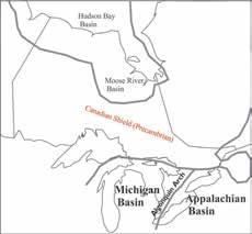
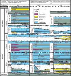
The Paleozoic sedimentary strata of southern Ontario straddle a regional arch, dipping down its flanks into the Michigan and Appalachian basins (Fig.1), forming a natural regional trap. Stratigraphic relationships of Silurian and Devonian strata which are the subject of this paper are depicted in Figure 2.
Ontario’s Silurian and Devonian strata have produced over 60 million bbl of oil and over 1.2 Tcf of natural gas from reservoirs at depths of less than 700 metres. In addition,
a total of 258 Bcf of natural gas working storage volume has been developed in depleted Silurian natural gas reservoirs in southern Ontario, and 22 million barrels of storage capacity for liquefied petroleum products in solution-mined caverns in Silurian salt formations. Ontario is Canada’s most populous and industrialized province, with well-developed infrastructure and a big appetite for hydrocarbons. Oil and gas development opportunities still remain for new pool discoveries, secondary recovery, and storage development.
Lake Erie (Figure 3). They are part of an extensive blanket of Silurian sands in the Appalachian Basin extending south through Pennsylvania, Ohio and New York, and into northern Kentucky that have produced over 11 Tcf of natural gas (McCormac et al., 1996).
During early Silurian time large amounts of sand, silt and clay were eroded from Taconic highlands to the south and were deposited into the Appalachian Basin. Sand deposition was restricted to the Appalachian side of the Algonquin Arch. The Whirlpool Formation is the lowermost of these clastic strata in Ontario. It rests unconformably on red shales of the Ordovician Queenston Formation and consists of white orthoquartzitic sandstone initially deposited in a braided fluvial environment, grading upwards into a shallow nearshore marine environment. It is gradationally overlain by and laterally transitional into Manitoulin Formation dolostone northwest of the Whirlpool depositional edge, and overlain by the Cabot Head Formation in the east.
The Lower Silurian
Sandstone Play Sandstones of the Lower Silurian Thorold, Grimsby and Whirlpool formations underlie an extensive area beneath the Niagara Peninsula and eastern and central
The Cabot Head Formation is comprised predominantly of grey-green noncalcareous shales with subordinate sandstone and carbonate beds. It occurs regionally in southern Ontario, ranging from 40 metres in thickness beneath Lake Erie to only 12 metres over the Algonquin Arch, thickening again to the northwest. It is gradationally overlain by interbedded red shales and sandstones of the Grimsby Formation, up to a maximum of 24 metres in thickness beneath Lake Erie. The Grimsby is disconformably overlain by clean white sandstone and grey-green silty shales of the Thorold Formation ranging up to 6.5 metres in thickness (Armstrong and Carter, 2010).
(Continued on page 20...) RESERVOIR ISSUE 10 • NOVEMBER 2016 19 TECHNICAL ARTICLE
Figure 1. Regional geological relationships, showing Paleozoic basins and the Algonquin Arch.
Figure 2: Stratigraphic relations of Silurian and Devonian strata of southern Ontario showing oil and gas-bearing intervals. Column headings indicate county names for geographic reference, from west (Michigan Basin) to east (Appalachian Basin) across southern Ontario. Modified from Armstrong and Carter (2010).
Within this wedge of clastic sediments, porosity is best-developed in sands of the Whirlpool, Grimsby and Thorold formations, and to a lesser extent in the Cabot Head Formation. They occur as extensive regional blankets and in channels and bars. In onshore parts of southern Ontario, porosity and permeability is generally best-developed and most consistent in the Thorold Formation. Beneath Lake Erie the most productive intervals are developed in the Grimsby and Whirlpool formations. Marine shales of the Rochester Formation form a regional seal for the Thorold/Grimsby sands.
Natural gas occurs wherever there is sufficient porosity development, making this a classic continuous-distribution style of play. The sands are part of an immense basin-centred stratigraphic trap extending south of Lake Erie into the states of Pennsylvania, Ohio and New York. Most wells drilled into the Thorold, Grimsby and Whirlpool in this area encounter natural gas, but commercial production depends on the relative percentage of sand vs clay and silt and degree of cementation. Predicting the location of these ‘sweet spots’ can be a challenge, with drilling success rates dropping to less than 50% for offshore Lake Erie gas development as the play has matured.
only a few pipelines before measurement, and production volumes are reported by administrative production units rather than geological pools. In addition, the generally low reservoir permeability makes it difficult to prove pressure communication between wells (Bailey and Cochrane, 1986). Recent infill wells into some of the more mature pools in Lake Erie have seen evidence of communication and depletion of some of these sandstone reservoirs.
wells on Lake Erie. With better porosity, horizontal permeability can range from 1 to 500 millidarcies. Water content is generally low and oil is usually absent in the up dip portion of this play (MacDougall, 1973, Molgat and Davies, 2004). Average annual decline rate is 10.92% and median value is 8.3% (Bailey and Cochrane, 1986).
The continuous nature of the reservoir, commingled production, the long drilling history, poor production records, and lack of pressure measurements makes it impractical to define pool boundaries and size with any confidence. In Lake Erie, production is largely commingled into
Average depth of the reservoirs ranges from as little as 60 metres up to 625 metres. Gross pay thickness varies from a few metres to ten metres or more in several pay zones, with some production occurring locally from the immediately overlying carbonates of the Irondequoit Formation (Figure 4). Net pay thickness is usually less than 2-5 metres (Fig. 5). Porosity ranges from 3% to 25%, with a 9% cutoff commonly used for
In the onshore portion of the play, in Norfolk County, initial reservoir pressures range from 400 to upwards of 700 psi. Initial natural production rates on successful wells average 50 to 100 Mcfd but this is greatly improved by fracture treatment. Most onshore wells are drilled with cable tool rigs to minimize formation damage. Offshore Lake Erie initial production rates range from gas shows to over 3 MMcf/d and cumulative production per well ranges from 0.05 to 3.0 Bcf (Molgat and Davies, 2004).
20 RESERVOIR ISSUE 10 • NOVEMBER 2016 TECHNICAL ARTICLE
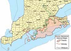
Figure 3. Silurian sandstone subcrop edges in Ontario. Modified from Bailey Geological Services and Cochrane (1986), and Lazorek and Carter (2008).
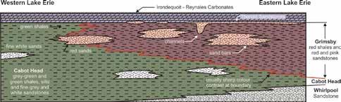
Figure 4. Conceptual cross-section through the Cabot Head-Grimsby clastics of eastern Lake Erie showing lateral facies changes. Modified from Bailey Geological Services and Cochrane, 1986, and Lazorek and Carter (2008)
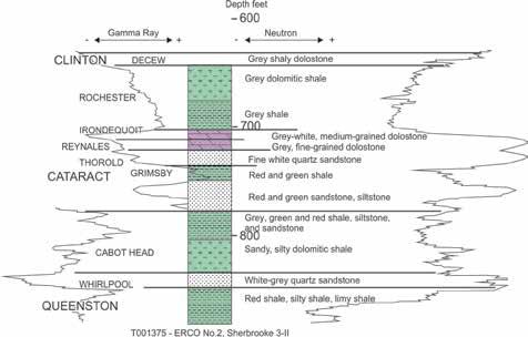
Figure 5. Type log of Lower Silurian clastics in southern Ontario.
Exploration and Production History
The Silurian sandstones are a mature exploration play and have been an important and reliable source of gas production since 1889. Gas production is recorded from 25 named pools, fields and Lake Erie production units. All of the large on-shore pools were discovered before 1910 and on Lake Erie between 1959 and 1970. Most of the development drilling on Lake Erie has occurred since 1968, with approximately 1600 wells drilled to test Silurian sandstone targets in an area of approximately 7,400 km2. Approximately 6000 wells have been drilled in the onshore portion of the play in an area of 4,500 km2. On-shore wells are drilled on 25 to 100acre spacing in developed areas. On Lake Erie, wells are drilled on 630-acre spacing. Down spacing to 315-acre spacing has been attempted with limited success in mature pools.
By the end of 2014, approximately 245 Bcf of gas had been produced on-shore and 235 Bcf had been produced from beneath Lake Erie (Ontario Oil, Gas and Salt Resources Library, 2015; Bailey and Cochrane, 1986), with all of the Lake Erie production occurring since the early 1960s. With only minor exceptions, all production from Silurian sandstones is natural gas. Total oil production from Silurian sandstones amounts to only 43,700 bbl of oil, the vast majority from the Onondaga pool south of the city of Brantford.
Resource Potential
Bailey and Cochrane (1986) calculated total “potential reserves” (discovered+undiscovered) of approximately 1.24 Tcf for the Silurian sandstone play using a volumetric method with a model area approach. They estimated recovery factors as low as 15% on Lake Erie. This is due to the low permeability, heterogeneous distribution of porosity and permeability, and the average 630 acre spacing of the wells. The Canadian Gas Potential Committee assumed a 65% recovery factor and estimated original gasin-place in discovered pools at 877.5 Bcf. In both cases, large volumes of natural gas remain to be produced.
There is no significant oil production from the on-shore portion of this play with the
exception of the Onondaga pool. Several wells drilled on Lake Erie encountered shows of oil, and 2 wells; Consumers’ 13022 Lake Erie 155-Y, and Consumers’ Pan American 13056 Lake Erie 100-J, tested significant flows of crude oil. Although there are likely to be potential oil resources in these sandstones beneath the lake, offshore oil production is not permitted by government regulation at this time, and wells with oil shows are required to be plugged. These sandstone reservoirs produce both oil and gas down dip along the south shore of Lake Erie in Pennsylvania and Ohio.
The Silurian “Niagaran” Carbonate Play
The Silurian carbonate play includes all reservoirs in the Lockport Group and those in the overlying Salina Group (Fig.2). Four types of traps have been recognized; pinnacle reefs, platform reefs, incipient reefs, and structural traps related to faulting (Bailey and Cochrane, 1990, Carter et al., 1994, Canadian Gas Potential Committee, 2005, Lazorek and Carter, 2008)
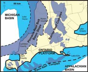
During deposition of the Lockport Group, southern Ontario and Michigan were located at about 20 to 250 south of the equator and North America was rotated about 300 clockwise from its present orientation (Rine, 2015). Most of southern Ontario was a shallow carbonate platform lying between the slightly deeper water of the slowly subsiding Michigan Basin to the west and the Appalachian Basin to the southeast. These conditions were ideal for the formation of barrier and patch reef complexes in the warm shallow waters of the Ontario Platform, and for the formation of isolated pinnacle and incipient reefs in the relatively deeper waters sloping into the Michigan Basin (Figure 6). In Michigan, these strata are known as the Niagaran, generally correlative to the Lockport Group.
Pinnacle reefs are reef buildups greater than 50 metres in height (Bailey and Cochrane, 1990), ranging up to 128 metres above the regional inter-pinnacle surface (McMurray, 1985), with basal areas ranging from 23 hectares to a maximum of 368 hectares where closely-spaced reefs form a reef complex with reservoir communication (Bailey and Cochrane, 1990). Incipient reefs
are usually less than 30 metres in height. Both reef types occur in a belt or trend approximately 50 km wide running through Lambton, Huron and Bruce counties, and extend completely around the Michigan Basin (Fig.6). Pinnacle reefs are the moststudied of the reefs due to their importance as oil and gas reservoirs.
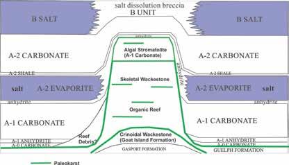
Reef development in Ontario began as crinoidal shoals in the Gasport and Goat Island formations with most biohermal development in the Guelph Formation. In Ontario, stages of reef development include a basal mud mound, organic reef, skeletal wackestones, and stromatolites, in vertical succession (Smith et al., 1993, Carter et al., 1994, Charbonneau, 1990) (Fig.7). These are very similar to stages and facies documented by Huh et al. (1977) and others in Michigan. Several episodes of subaerial exposure have been documented in pinnacle reefs, creating erosional discontinuities and extensive paleokarst horizons, leading Brintnell (2012) to describe pinnacles as karst towers. Post-depositional subaerial exposure in southern Ontario has reduced the interreef Guelph Formation in southern Ontario to a paleosol karst rubble 2 to 6 metres thick (Carter et al, 1994).
Most reefs in southern Ontario have been intensively dolomitized, resulting in destruction of almost all primary depositional fabric, with intensity of dolomitization increasing toward the platform (Coniglio et al, 2003). Infiltration of hypersaline seawater during deposition of salt beds in the overlying Salina Group has created issues with salt plugging in some Ontario pinnacles.
In Ontario the net result is a complex, stratified reservoir with widely varying porosity and permeability, both vertically and laterally. Recent work in Michigan has identified distinct differences in windward and leeward reef margins (Grammer et al., 2010; Rine, 2015). The reefs were buried by carbonates, evaporites and minor shales of the Upper Silurian Salina Group and are sheathed with a layer of anhydrite (Figure 7) that forms the seal for these reservoirs.
Patch or platform reefs generally exhibit less than 50 metres of buildup but underlie
(Continued on page 22...) RESERVOIR ISSUE 10 • NOVEMBER 2016 21 TECHNICAL ARTICLE
very large geographic areas on the platform east of the pinnacle reef belt. Most of these reefs have been dolomitized. Discovered pool sizes range up to a maximum of 280 Bcf of natural gas in the Tilbury platform reef. Many of these reefs contain dissolved H2S, up to 2% concentration.
Individual pinnacle reefs may contain up to 42 Bcf of natural gas and 1.6 million barrels of oil. Depths to top range from 300 to 700 metres. Gas pay thicknesses range up to 95 metres, with initial open flow in discovery wells commonly exceeding 10 MMcf/d with a maximum reported of 65 MMcf/d (Bailey and Cochrane, 1990), and initial shut-in pressures up to 1000 psig. Porosity varies considerably within individual reefs due to the complex, heterogeneous internal stratification, reef vs. non-reef facies, karst, salt-plugging, and post-depositional and post-burial diagenesis. Average measured porosity reported in 29 different drill core analyses from 18 different pinnacle reefs which have now been converted to natural gas storage is 7.7%, with some thin intervals exceeding 30% porosity and maximum horizontal permeability of 1,000 to 10,000 millidarcies (Carter et al., 1996).
Hydrocarbons also occur in dolomitized zones of the Salina A-1 and A-2 Carbonate units. Traps most commonly occur where dolomitized carbonates of the Salina A-1 and A-2 are upthrown along with Guelph dolostones along regional faults as well as in structural drapes of A-1 and A-2 over the Guelph reef buildups.
Exploration and Production History
Niagaran reefs have been a major exploration target and source of hydrocarbons in Ontario and Michigan for several decades. Over 900 discrete pinnacle reef reservoirs have been discovered in the Michigan Basin (Armstrong and Goodman, 1990, Armstrong et al., 2002). These pools have produced over 490 million barrels of oil and 2.9 Tcf of natural gas (Grammer et al., 2010).
In southern Ontario, approximately 5000 wells have been drilled to test targets in Silurian carbonate rocks. In 1889, the first commercial gas well in Ontario was completed by Eugene Coste in Essex County in the Kingsville-Leamington-Mersea Field. Production was from the Guelph Formation and the Salina A-1 Carbonate with an initial gas flow reported at more than 10 MMcf/d at a depth of 1030 feet and a pressure of 420 psi (Lauriston, 1961). This well marked the beginning of the natural gas industry in Ontario. Initial follow-up drilling to this discovery focused on oil producing reservoirs, most with associated natural gas. In late 1905, the Tilbury field was discovered with the drilling of the Kerr No. 1 well in Tilbury East Township. At the time it was produced as an oil well, occurring as it did at the transition between the oil and gas legs of the field. The oil accumulation is now known as the Fletcher Oil Pool. The natural gas was flared, as there was no viable market for it. Subsequent drilling eventually resulted in the realization that a very large gas field had been discovered
and it had considerable value for energy and lighting. The Tilbury Gas Field is by far the largest natural gas reservoir in Ontario, with cumulative production of at least 280 Bcf of natural gas, and 1.2 million barrels of oil from the associated Fletcher Oil Pool. Actual production may have been much higher due to initial poor record keeping and wasteful gas flaring practices after discovery. The oil pool was prematurely abandoned as the scrap metal value for the casing during World War I was more valuable for the war effort. This oil and gas reservoir consists of a platform reef in the Guelph Formation and associated porosity in the overlying, draping A-1 and A-2 Carbonate units.
Production from the Tilbury field provided a reliable supply of natural gas that resulted in the creation of a large number of competing gas syndicates to deliver and market the gas. It was the initial mainstay of natural gas production for the Union Gas Company. Union Gas Limited, now a division of Spectra Energy, became Ontario’s largest natural gas utility through competition and a process of acquisition and merger, supplying natural gas to domestic and industrial users across large parts of southern Ontario. Enbridge, Union’s main competitor in southern Ontario, recently announced plans to merge with Spectra.
In total, 182 reservoirs have been discovered in the Niagaran play in southern Ontario; 57 in incipient reefs, 61 in pinnacle reefs, 29
22 RESERVOIR ISSUE 10 • NOVEMBER 2016 TECHNICAL ARTICLE
Figure 6. Reef belts in Ontario. Modified from Coniglio et al., 2003.
Figure 7. Pinnacle reef conceptual model, based on Carter et al (1994), Rine (2015), Huh et al (1977), Bailey (2000), Charbonneau (1990), Smith et al (1993).
in platform reefs, and 35 in structural traps. Pool production records at the Ministry of Natural Resources and Forestry and the Oil, Gas and Salt Resources Library indicate that the first pinnacle reef reservoirs were discovered in 1930 and 1931, and the next not until 1941. Between 1949 and 1958 there was a string of successes with discovery of 19 additional pinnacle reef reservoirs. Gravity prospecting techniques were used with some success at this time. With improvements in seismic acquisition and processing (Mantek, 1976) an additional 32 productive pinnacles were drilled between 1965 and 1992. Only 8 have been drilled subsequently as a result of declining exploration activity. Drilling success for incipient reefs follows a similar trend. Reservoirs in structural traps were discovered intermittently beginning in 1902, with the most active period occurring from 1948 to 1959 when 14 of the 35 known pools were discovered.
By the end of 2014, approximately 15.1 million bbl of oil had been produced from the Silurian carbonates in southern Ontario. Gas production has totaled approximately 331 Bcf from onshore reservoirs with an additional 443 Bcf from beneath Lake Erie.
Natural Gas Storage
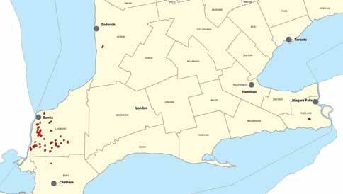
Ontario imports 99% of the approximate 1 Tcf of natural gas it consumes each year, largely from western Canada but with increasing quantities from the northeastern United States. Pipeline capacity is not large enough to supply peak demand in the winter, so natural gas is injected underground into depleted natural gas reservoirs in the summer for temporary storage. In the winter, the gas is withdrawn from storage to satisfy increased demand. Thirty-two pinnacle reefs and 2 incipient reefs have been converted to natural gas storage, with total working volume of 269 Bcf of natural gas and combined peak withdrawal capacity of over 5 Bcf/d All pools are delta-pressured above discovery pressure to increase working capacity, which varies from 1.7 to 34 Bcf The pools are serviced by 309 injection/withdrawal wells and 78 observation wells. Most of these reservoirs are located in Lambton County, with one in Kent County and two in Huron County. One small storage pool located in Welland County is developed in porous
sandstone of the Whirlpool Formation (Fig.8). The development of gas storage is regulated by the Ontario Energy Board.
Experimental injections were performed in southern Ontario as early as 1915 to test the feasibility of storing natural gas in depleted natural gas reservoirs. The first commercial underground storage of natural gas in geological formations in Canada began in 1942 in the Dawn 47-49 pinnacle reef, north of Sarnia. Dawn 47-49 was also the first pinnacle reef gas reservoir discovered in Ontario, in 1930. With completion of gas pipelines from western Canada to Ontario in 1957 there was an increase in natural gas supply which then spurred development of additional storage capacity (Wolnik, 2007). Most of the conversions of depleted reservoirs into storage reservoirs occurred between 1960 and 2000.
Potential Resources
This is a mature play, but still with opportunities for further discoveries both on and offshore. There is potential for discovery of isolated reservoirs within previously delineated reefs which have been only partially affected by saltplugging, as well as opportunities for enhanced recovery from developed reservoirs. The concept of Rine (2015) regarding leeward debris aprons around pinnacle reefs has not been applied to reservoir development in Ontario. The karst tower concept of Brintnell (2012) may also
be useful. There is potential for conversion of additional reefs for use as natural gas storage reservoirs. While early exploration methods focused on gravity anomalies to locate pinnacle reefs, 2D seismic is now far more important in combination with careful study of drill cuttings samples to identify reef proximity indicators. Detailed mapping of dolomitization patterns and thickness variation of the Salina A-1 Carbonate Unit may also provide a useful guide to undiscovered pinnacle reefs. 3D seismic has been acquired over most reefs that are utilized for natural gas storage in order to accurately define closure for establishment of regulatory boundaries and to optimize infill drilling locations for storage development.
Incipient reefs are a largely overlooked target in this play because of the difficulty in reliably targeting these elusive traps. Most of the incipient reefs discovered to date were found while exploring for pinnacle reefs. An exploration program directed at incipient reefs could be rewarding if a consistently successful exploration method were devised. The smaller size of these reservoirs requires a high drilling success rate.
The structural play is poorly understood and the importance of dolomitization related to faulting has not been widely recognized. Further study may create opportunities for new pool discoveries.
(Continued on page 24...) RESERVOIR ISSUE 10 • NOVEMBER 2016 23 TECHNICAL ARTICLE
Figure 8. Natural gas storage pools (red) in southern Ontario. The one storage pool in Welland County is in Whirlpool Formation sandstone, the rest are in Guelph reefs.
Estimates by Bailey and Cochrane (2016) indicate total “potential reserves” (discovered+undiscovered) of approximately 1.0 Tcf of natural gas and 18.1 MMbo. Cumulative production to the end of 2014 totals 15.1 MMbo and 774 Bcf of natural gas.
The Devonian Play
The Middle Devonian play includes reservoirs in the Lucas Formation and the overlying Dundee Formation (Figure 2).
During early Middle Devonian time, the seas in northeastern North America were restricted to two large epicontinental basins: the Michigan and Appalachian basins. The basins were separated by a northeast-southwest tending basement high known as the Algonquin Arch, with the Michigan Basin located to the northwest and the Appalachian Basin to the southeast of the arch (Figure 1). Throughout much of the early Middle Devonian the basins were largely independent, with some communication likely in the Chatham Sag area and also through an inlet northeast of London (Fagerstrom, 1983). The Michigan Basin periodically experienced conditions of hypersalinity whereas the Appalachian basin sediments were deposited under open marine conditions throughout this time interval. The seas then transgressed over the Algonquin Arch and merged into an open marine environment of normal salinity. The marine incursion resulted in erosion of the upper Detroit River Group and a disconformity separates the Lucas Formation from the overlying Dundee Formation. The presence of numerous hardground surfaces and thickly-bedded bioclastic limestones in the Dundee Formation attest to relatively shallow water, subtidal conditions. A major disconformity separates the Dundee Formation from the overlying Hamilton Group (Uyeno et al., 1982).
The Detroit River Group unconformably overlies the Bois Blanc Formation and is composed of, in ascending order, the Sylvania Sandstone, Amherstburg Formation and the Lucas Formation. Several lithofacies comprise the Lucas Formation including laminated lime mudstones, peloidalintraclastic packstones to grainstones, stromatoporoid floatstones, dolomicrites
to finely crystalline dolostones, calcareous sandstones, and minor evaporates. These lithofacies indicate a peritidal environment subjected to periodic exposure.
The Dundee Formation is characterized by rocks and fossils typical of a shallow marine, subtidal environment which contrasts with the generally peritidal carbonates of the Lucas Formation. Four lithofacies are recognized in the Dundee Formation: packstone to grainstone, wackestone to packstone, mudstone to wackestone, and mudstone.
The Lucas Formation hosts two distinct reservoir types; a microcrystalline dolomite unit and a calcareous sandstone. The dolomite unit is the primary reservoir in the Oil Springs Pool and has porosity in the range of 12 to 30%, with permeability of 5 to 430 md. The sandstone unit is the producing reservoir in the Glencoe Pool where porosity ranges from 10 to 21% and permeability generally varies from 50 to 200 md.
Reservoirs in the Dundee Formation reservoir are characterized by a significant unit known as the “Columbus zone”, with additional production from fracture porosity as well as from a microporous matrix within fractured limestones. The Columbus zone is a siliciclastic-rich dolomitized limestone with porosity commonly in the 12 to 30 % range and permeability varying between 50 and 2500 md and is the producing reservoir in the Rodney Pool.
All of the middle Devonian pools (Figure 9) are located on structural domes which are the result of differential dissolution of salt beds in the underlying Salina Group (Figure 10). Brigham (1972) suggested that there were two major periods of salt dissolution which affected Middle Devonian sedimentation and structure.
History of the Play and Production
The Middle Devonian Lucas and Dundee formations of Ontario have produced approximately 45.1 million barrels of oil (MMbo), which equates to approximately 50% of Ontario’s oil production to date. The first commercial oil production in North America was from these shallow Middle Devonian carbonates in 1858 at Oil Springs,
Ontario. Three of the largest oil fields in Ontario are Middle Devonian in age and include Petrolia (18.8 MMbo), Rodney (10.8 MMbo), and Oil Springs (10.4 MMbo). Bothwell-Thamesville (3.3 MMbo) and Glencoe (1.1 MMbo) were also significant discoveries (Table 1). Since 1858, a total of 27 Middle Devonian pools have been put on production. One hundred and fifty-eight years later, four of these early discoveries are still producing.
With the exception of the Rodney Pool, which was discovered in 1949, the major discoveries, due to their vintage, have very limited documentation or data (Bailey and Cochrane, 1985). The lack of data includes accuracy of well locations, detailed production information, reservoir pressures, and rock samples. Fortunately, historical information was recorded within reports and unpublished manuscripts prepared by Colonel R.B. Harkness, a former Ontario oil and natural gas commissioner, between 1915 and 1951. Harkness documented an Oil Springs well that had an initial flow of 7,500 bopd and numerous wells in Petrolia with initial flows exceeding 400 bopd. A number of the Harkness notations reference enormous volumes of oil spilled on the surface and into adjacent creeks due to the inability of operators to control the high flow rates, as well as insufficient tank storage capacity. In one documented occasion an uncontrolled well flowed enough oil to cover Lake St. Clair with an oil slick several inches thick.
Early exploration methods were limited to drilling surface oil seeps and tar beds and the practice of drilling surface test holes to define the top of the bedrock for structural mapping. Since the Rodney discovery in 1949 there have been no significant Middle Devonian discoveries. This may be in large part due to an industry change in exploration focus.
24 RESERVOIR ISSUE 10 • NOVEMBER 2016 TECHNICAL ARTICLE
Middle Devonian Rodney Pool
The Rodney Pool was discovered in 1949 by using shallow test wells to define structure on the top of the Dundee Formation. Initial production rates varied per well from 2 to 118 bopd, with an average of 20 bopd (Malcolm, 1962). By 1956, production from the pool had peaked at 1,120 bopd with the completion of 193 wells drilled on an average of 6.25 acre spacing (Malcolm, 1962). In 1961, the operator, Canada Cities Service commenced water-flooding the pool and the company reported that production from wells enhanced by waterflood ranged from 2 to 81 bopd with an average of 12 bopd (Malcolm, 1967). Oil recovery per well at that time ranged from 2,000 to 45,000 barrels with an average of 13,000 barrels. At peak performance, the water-flood resulted in a 232% increase in daily production volumes and an estimated 55% recovery of the original oil-in-place. After sixty-seven years of production the Rodney Oil Pool is still producing approximately 66 bopd with a relatively low decline rate.
The Rodney Pool is a good example to illustrate a Middle Devonian pool in Ontario due to the relatively recent timing of development and availability of accurate geological and engineering data. The Rodney and 7-D-VII pools (Figure 11) are situated to the east of a large northeastsouthwest trending fault structure. The fault was instrumental in providing the mechanism for the dissolution of up to 60 meters of salt in the underlying Salina Group to the west of the fault in postMiddle Devonian time. Approximately 50 to 55 meters of Salina salt is preserved
underlying the Rodney pools to the east of the fault. The salt remnant provided the basis for structural traps within the overlying Middle Devonian section with 10 to 15 meters of closure.
A type log from a productive well in Rodney is illustrated in Figure 12.
Exploration Potential
Over the past 35 to 40 years there has been very little exploration effort directed towards the Middle Devonian reservoirs. In part, this may be due to the success of exploration for Silurian and Ordovician reservoirs. Within the Middle Devonian pool fairway (Figure 9) there are numerous areas with a relatively low-drilling density that have the potential for localized Silurian Salina salt remnants and the development of coincident shallow Devonian structures. In addition, a significant amount of 2D seismic data has been acquired in those areas in search of Silurian pinnacle reefs that is possibly available for purchase and reprocessing. The Ontario Geological Survey acquired and released a highresolution magnetics survey in 2010 that covers a portion of the Middle Devonian fairway. This may assist in defining the location of deep-seated faults and salt dissolution patterns.
From an economic perspective, the Middle Devonian reservoirs continue to be an attractive geological target, due to their shallow depth (120-150 meters), highgravity oil (380 API), relatively high yields (30,000 to 60,000 barrels per well) and long productive life-span. Prospective areas within the Devonian pool fairway (Figure
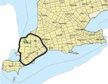
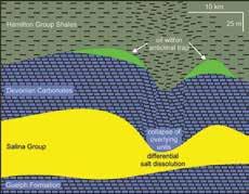
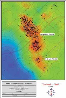
(Continued on page 26...) RESERVOIR ISSUE 10 • NOVEMBER 2016 25 TECHNICAL ARTICLE
POOL NAME DISCOVERY YEAR CUMMULATIVE PRODUCTION (barrels) ACTIVE Oil Springs 1858 10,437,000 Yes Petrolia 1862 18,798,000 Yes Bothwell-Thamesville 1862 3,354,000 Yes Wallacetown 1898 253,000 No Glencoe 1917 1,139,000 No Watford-Kerwood 1938 132,000 No Rodney 1949 10,845,000 Yes
Table 1. Cumulative production of major Middle Devonian oil pools by discovery year to 2015, rounded to nearest 1000.
Figure 9. Devonian pool fairway (Lazorek and Carter, 2008).
Figure 10. Conceptual model of Devonian structural traps formed by differential salt dissolution in the underlying Salina Group (after Lazorek and Carter, 2008).
Figure 11. Structure on top of the Dundee Formation Rodney and 7-D-VII pools.
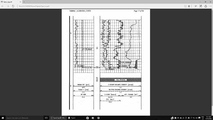
9) have been only lightly explored, and the potential exists for new discoveries.
Summary
Like most plays in Ontario, the Silurian and Devonian plays have a long history of successful exploitation and have made significant contributions to Ontario’s production of oil and natural gas. Estimates of potential remaining resources suggest there are still significant discoveries to be made, in addition to opportunities for secondary recovery and for natural gas storage. Positive factors to consider are the size and quality of the discovered pools, the presence of highly developed infrastructure, and the excellent data resources available at the Ontario Oil, Gas and Salt Resources Library.
References
Armstrong, D.A., and Carter, T.R., 2010. The subsurface Paleozoic stratigraphy of southern Ontario; Ontario Geological Survey, Special Volume 7, 301 p.
Armstrong, D.K., and Goodman, W.R., 1990. Stratigraphy and depositional environments of Niagaran carbonates, Bruce Peninsula, Ontario; Ontario Petroleum Institute, AAPG Eastern Section Meeting, Field Trip Guidebook 2, 59 p.
Armstrong, D.K., Goodman, W.R., and Coniglio, M., 2002. Stratigraphy and depositional environments of Niagaran carbonates, Bruce Peninsula, Ontario;
Ontario Petroleum Institute, Field Trip Guidebook, Sep.20-22, London, Ontario, 60 p.
Bailey Geological Services, and Cochrane, R.O. 1985. Evaluation of the conventional and potential oil and gas reserves of the Devonian of Ontario; Ontario Geological Survey Open File Report 5555, 178 p.
Bailey Geological Services, and Cochrane, R.O. 1986. Evaluation of the conventional and potential oil and gas reserves of the Silurian sandstone reservoirs of Ontario; Ontario Geological Survey Open File Report 5578, 275 p.
Bailey Geological Services, and Cochrane, R.O. 1990. Geology of selected oil and gas pools in the Silurian carbonates of Ontario; Ontario Geological Survey Open File Report 5722, 50 p.
Bailey Geological Services, and Cochrane, R.O., 2016. Previously unpublished diagrams for final report on oil and gas potential of Ontario; Ontario Oil, Gas and Salt Resources Library, Open File Data Release 2016-1.
Bailey, S.M.B., 1986. A new look at the development, configuration, and trapping mechanisms of the Silurian Guelph reefs of southwestern Ontario; Ontario Petroleum Institute 25th Annual Conference, vol. 25, Technical Paper 16, 28 p.
Bailey, S.M.B., 1999. The timing and mechanics of emplacement and removal of salt, in and around pinnacle reefs in southwestern Ontario: the Enniskillen 28 reef model; Ontario Petroleum Institute 38th Annual Conference, vol. 38, Technical Paper 7, 31 p.
Bailey, S.M.B., 2000. The extremely complicated ‘simple’ pinnacle reef reservoirs of Ontario; Ontario Petroleum Institute 39th Annual Conference, vol. 39, Technical Paper 3, 33 p.
Brigham, R.J., 1972, Structural geology of southwestern Ontario and southeastern Michigan, Mines and Northern Affairs Petroleum Resources Section, Paper 71-2, 1110 p.
Brintnell, C. Architecture and stratigraphy of the Lower Silurian Guelph Formation, Lockport Group, southern Ontario and Michigan; University of Western Ontario, unpublished MSc thesis, 242 p.
Canadian Gas Potential Committee 2005. Central Canada assessment region; in Natural Gas Potential in Canada 2005: Frontier Basins of Canada, Canadian Gas Potential Committee, Calgary Alberta, v.3, p.90-103.
Carter, T.R., 1991. Dolomitization patterns in the Salina A-1 and A-2 Carbonate Units, Sombra Township, Ontario; Ontario Petroleum Institute, 30th Annual Conference, London, Ontario, Technical Paper 4, 35 p.
Carter, T.R., Trevail, R.A., and Smith, L., 1994. Core workshop: Niagaran reef and inter-reef relationships in the subsurface of southwestern Ontario; Geological Association of Canada 1994 Annual Meeting, Waterloo, Ontario, Field Trip A5 Guidebook, 37 p.
Carter, T.R., Trevail, R.A. and Smith, L. 1996. Geology of a natural gas storage pool: Silurian pinnacle reefs in southern Ontario, in Pools ’96; Canadian Society of Petroleum Geologists, Core Conference, p.3-1 – 3-10.
Charbonneau, S.L., 1990. Subaerial exposure and meteoric diagenesis in Guelph Formation (Niagaran) pinnacle
26 RESERVOIR ISSUE 10 • NOVEMBER 2016 TECHNICAL ARTICLE
Figure 12. Log section of a productive well in Rodney. GGOL #13, Aldborough D-VII. Initial flow 5 bopd with a shut-in pressure of 175 psig.
reef bioherms of the Michigan Basin, southwestern Ontario; Queen’s University, unpublished MSc thesis, 215 p.
Coniglio, M., Zheng, Q. and Carter, T.R. 2003. Dolomitization and recrystallization of middle Silurian reefs and platformal carbonates of the Guelph Formation, Michigan Basin, southwestern Ontario; Bulletin of Canadian Petroleum Geology, v.51, no.2, p.177-199.
Fagerstrom, J.A., 1983, Petrology and regional significance of a Devonian carbonate/evaporate complex, eastern Michigan Basin, Journal of Sedimentary Petrology, Vol.53, p. 295-317.
Grammer, G. Michael; Noack, Amy K.; Qualman, Heather; Ritter‐Varga, Audrey; Wold, Jessica; Sandomierski, Anthony E.; Harrison, William B., 2010. Reservoir characterization of Silurian (Niagaran) “pinnacle” reefs in the Michigan Basin; American Association of Petroleum Geologists, 2010 Annual Conference, New Orleans, abstract.
Harkness, R.B., The Harkness Files, Chapter 1 Lambton County, Sections I-X. Oil, Gas and Salt Resources Library.
Huh, J.M., Briggs, L.Il, and Gill, D., 1977. Depositional environments of pinnacle reefs, Niagara and Salina Groups, northern shelf, Michigan Basin; p.1-21 in Fisher, J.H., (ed.), Reefs and Evaporites; American Association of Petroleum Geologists, Studies in Geology, 196 p.
Johnson, MD., Armstrong, D.K., Sanford, B.V., Telford, P.G., and Rutka, M.A. 1992. Paleozoic and Mesozoic geology of Ontario, in Geology of Ontario; Ontario Geological Survey Special Volume 4, Part 2, p. 9061008.
Lauriston, V., 1961. Blue flame of service. Union Gas Company of Canada, Chatham, Ontario, Canada, 126 p.
Lazorek, M., and Carter, T.R., 2008. The oil and gas plays of Ontario. Ontario Petroleum Institute; Ontario Oil&Gas June 2008 June 2008, p.18-27.
MacDougall, T.A., 1973. The oil and gas potential of the “Clinton-Cataract”
reservoirs of Norfolk County; Ontario Ministry of Natural Resources, Petroleum Resources Section, Paper 73-2, 72 p.
Malcolm, W., 1962, Canada Cities Service Rodney Waterflood Unit, Ontario Petroleum Institute Volume, Session 7, 30 p.
Malcolm, W., 1967, A Progress Report on the Canada Cities Service Rodney Waterflood Unit, Ontario Petroleum Institute Volume, 27 p.
Mantek, W., 1976. Recent exploration activity in Michigan; Ontario Petroleum Institute, 15th Annual Conference, Technical Paper 1, 33 p.
McCormac, M.P., Mychkovsky, G.O., Opritza, S.T., Riley, R.A., Wolfe, M.E., Larsen, G.B., and Baranoski, M.T., 1996. Plat Scm: Lower Silurian Cataract/Medina Group (“Clinton”) sandstone play, in Atlas of major Appalachian gas plays, John Roen and Brian Walker eds.; West Virginia Geological and Economic Survey, p.156163.
McMurray, M., 1985. Geology and organic geochemistry of Salina A-1 Carbonate oil source-rock lithofacies (Upper Silurian), southwestern Ontario; MSc thesis, University of Waterloo, Waterloo, ON, 236 p.
Molgat, M., and Davies, L., 2004. A model for exploring and developing Silurian clastic reservoirs in the Appalachian Basin: the east Lake Erie experience; Ontario Petroleum Institute, 43rd Annual Conference, V.43, 9 p.
Ontario Geological Survey, 2011. Regional structure and isopach maps of potential hydrocarbon-bearing strata for southern Ontario; Ontario Geological Survey, Miscellaneous Release—Data 276.
Ontario Oil, Gas and Salt Resources Library, 2015. Oil and gas pools and pipelines of southern Ontario.
Rine, M., 2015, Depositional Facies and Sequence Stratigraphy of Niagara-Salina Reef
Complex Reservoirs of the Guelph Formation, Michigan Basin: Master’s Thesis, Western Michigan University,
Kalamazoo, Michigan.
Sanford, B.V. 1961. Subsurface stratigraphy of Ordovician rocks in southwestern Ontario; Geological Survey of Canada, Paper 60-26, 54p.
Sanford, B.V. and Quillian, R.G. 1959. Subsurface stratigraphy of Upper Cambrian rocks in southwestern Ontario; Geological Survey of Canada, Paper 58-12, 17p.
Sanford, B.V., Thompson, F.J. and McFall, G.H. 1985. Plate Tectonics – a possible controlling mechanism in the development of hydrocarbon traps in southwestern Ontario; Bulletin of Canadian Petroleum Geology v.33, p.52-71.
Smith, L., Charbonneau, S.L., and Grimes, D.J., 1993. Karst episodes and permeability development, Silurian reef reservoirs, southwestern Ontario; Ontario Geological Survey, Open File Report 5850, 240 p.
Uyeno, T.T., Telford, P.G. and Sanford, B.V., 1982, Devonian conodonts and stratigraphy of southwestern Ontario, Geological Survey of Canada Bulletin 332.
Wolnik, J., 2007. Gas storage – the past, present and future; Ontario Petroleum Institute, 46th Annual Conference, Technical Paper 11, 17 p.
RESERVOIR ISSUE 10 • NOVEMBER 2016 27 TECHNICAL ARTICLE
Quarterly Commodity Pricing Update
At the time of writing, OPEC just announced their agreement to cut the group’s crude oil output to 32.5 to 33 million barrels per day. Some are arguing about the specific terminology, saying it’s really only an “agreement to agree” or “an understanding that an agreement needs to be reached” and that the details remain to be seen. Nonetheless, OPEC’s most powerful member, Saudi Arabia, has offered to reduce its production, which is a sign they may be willing to adjust their strategy. This is, without a doubt, welcome news to the industry, even if there remains disagreement about the degree to which crude prices will truly be affected.
2016’s third quarter experienced limited volatility in crude oil prices, with Brent and WTI spending most of their time in the 45 to 50 USD/bbl range. Some are saying that with OPEC’s deal, this may represent a new floor on oil prices, though most remain skeptical that a hard floor is truly possible in the current global market. While US crude output is down nearly one million barrels per day since peaking in April 2015, Russian crude production is at record post-Sovietera levels, and OPEC production, even with the suggested cut, is three million barrels per day higher than in 2014. The expectation now is that OPEC will pursue further agreements with “OPEC plus” countries, like Russia, which has expressed interest in the past.
Markets may still respond further as they digest the deal. Global crude demand is still healthy and growing at an estimated 1.1 million barrels per day, per year. While some forecasters are a little more bearish, the IEA currently expects a supply-demand balance to be reached by late 2017, which could have a significant impact on market sentiment even if widely expected. Current futures and options prices imply a 95% confidence level for December 2017 WTI crude prices of 25 USD/bbl to 105 USD/bbl.
Similar to crude, the US Dollar has traded in a relatively narrow range against a basket of currencies since the beginning of summer. The Loonie has spent the entire quarter in a fairly tight range, with the US Dollar priced between 0.75 to 0.78 per CAD. This is primarily due to an absence of any unexpected news on interest rates as well as, probably most of all,
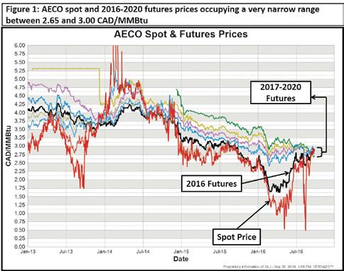
the tight crude oil trading range.
Canadian crudes have been priced at historically normal differentials to the WTI benchmark, with light, sweet crude at Edmonton discounted between 1.50 and 4.00 USD/bbl and heavy WCS crude at Hardisty discounted between 12 and 15 USD/bbl.
North American natural gas prices had a relatively calm but strong third quarter, finishing slightly higher again following their very strong second quarter. Henry Hub near month contracts are right around the 3.00 USD/MMBtu mark. Natural gas in Alberta, still experiencing a steep discount to the Henry Hub benchmark, is nonetheless higher than it’s been in nearly a year, with AECO spot prices around 2.90 CAD/MMBtu. Gas sold into the Spectra system at the Station 2 location near Chetwynd, British Columbia, is currently 0.35 CAD/MMBtu below AECO, at about 2.55 CAD/MMBtu. The Canadian natural gas industry received positive news when the Canadian federal government conditionally approved the Pacific NorthWest LNG project, but it remains to be seen whether the project will, in fact, go ahead.
LNG export economics to Asia are not nearly as rosy as they were a few years ago, and global competition is arguably a step ahead of Canada in meeting their needs. If the project does proceed, it’s uncertain whether it will actually move Canadian gas prices or if it will just allow additional volumes to be brought on-stream with prices remaining status quo.
In Europe, natural gas prices are about flat since last quarter, with UK (NBP) gas trading lower for most of the quarter, but currently hovering around 5.25 USD/MMBtu. Japanese LNG prices were around 6.00 USD/MMBtu in August, highlighting the relative economic difficulty of a Canadian LNG export project compared to 2014, when prices reached the 15 to 20 USD/MMBtu range.
Finally, Figure 1 shows the wild volatility of Alberta AECO gas prices in 2016 along with the extremely tight range currently occupied by current (spot) prices and forward curves alike. Whether Alberta producers are selling their gas to the spot market or looking to hedge forward production, there’s little variation in the prices they’ll see.
28 RESERVOIR ISSUE 10 • NOVEMBER 2016
ARTICLE
2016 – Beating the Economy and the Weather the CSPG Mixed Golf Tournament
David Middleton & Brenda Pearson 2016 co-chairs, CSPG Mixed Golf Committee
The 27th (actually 26th running) of the Annual CSPG Mixed Golf tournament enjoyed much better weather compared to August of 2015. While the day was a bit cool to start with, the bright blue skies were a welcome reprieve from the monsoon rain and cold that dogged the tournament last year, forcing the cancellation of the event. This year, we are pleased to report on a successful tournament, despite both a drop in attendance due to many members being un-employed, and a corresponding precipitous drop in sponsorship. We certainly appreciate the support we get from our participants and sponsors
The CSPG members, sponsors and guests teed off at 8:00 am in the sunshine, and the Lynx Ridge course was in great shape and the best ball tournament concluded in a little over 4.5 hours. The team low net trophy and tournament winner was the team of Brian Fyke, Terry Phillips, Andrea Henry and Megan Lee. The low gross score trophy was taken by the team of Brenda Pearson, Bob Earle, Fraser Salmon and Rhys Borshneck, and the Spirit Award “fossil coprolite” trophy went to the most honest team of Kirk Osadtz, Catherine Osadetz, Bernadette Gunn and Robert Gunn.
The state of the economy definitely had a bearing on the 27th annual tournament, but we were pleased to have our support from
our gracious sponsors, and we appreciate each and every one of them. The on-course beverage cart was sponsored by geoLOGIC Systems, who provided much appreciated drinks and food throughout the course. All teams enjoyed a hot breakfast provided by MJ Systems, used golf carts sponsored by Chinook Consulting Services, and benefited from visiting hospitality tents and skill/challenge contests provided by AGAT Laboratories Hole-in-One contest and the BrokerLink meet and greet hole. Prize holes were additionally sponsored by Belloy Petroleum Consulting, Birchcliff Energy, and ProGeo Consultants. We certainly appreciated the prize donations by Loring Tarcore, Trimble Engineering, Seisware, Typhoon Energy, CEO Platinum Round Table, Sylvan Safety Services, Cougar Consultants, Hawk Machine Works and the always popular Belloy Petroleum Consultants cooler filled with beer.
During the delicious banquet steak dinner, the pictures taken by GeoLOGIC were shown on the large screen for all to enjoy. Belloy Petroleum’s (Brian Fyke) weekend survival kit of a cooler filled with beer was won by Norm Hopkins. Skill prizes were awarded to golfers, and there was certainly some confusion as to which gender some members were putting their names down for awards, but the committee assigned the prizes to what was felt to be the valid winners at the events.
In the end, the members, guests, sponsor players and representatives enjoyed a great day catching up with colleagues, making new friends, and succeeded in raising over $1400 to support the educational and outreach activities of the CSPG.
I would like to thank the many sponsors, golfers, and the greens-keeping, pro shop and catering team at Lynx Ridge Golf course and especially the fine organizing committee of co-chair Brenda Pearson (registration), Darin Brazel (sponsorship), Norm Hopkins (trophies), Jeff Boissonneault (signage) , Penny Christensen (Prizes) and our CSPG office support from Kristy Casebeer. Hopefully, by the time this is published, all the pictures taken by various groups (thanks geoLOGIC) will be on the CSPG website.
We look forward to your attendance at next year’s tournament on Friday, 25 August 2017 as we celebrate the 28th Annual tournament.
RESERVOIR ISSUE 10 • NOVEMBER 2016 29 ARTICLE
Low Net Team
Low Gross Team
High Gross Team
CORPORATE SUPPORTERS
Baker Hughes Calgary
Bannatyne Wealth Advisory Group
Birchcliff Energy Ltd.
Cabra Consulting Ltd.
Canadian Global Exploration Forum
CAPL
Compass Directional Services
ConocoPhillips
Crescent Point Energy Trust
Earth Signal Processing Ltd.
Encana
EV Cam Canada Inc.
Halliburton
I H S
Integrated Sustainability Consultants Ltd.
ITG Investment Research
McDaniel & Associates Consultants Ltd.
Mount Royal University
Navigator Resource Consulting
Pro Geo Consultants
Richardson GMP
RIGSAT Communications
Roke Technologies Ltd.
RPS Energy Canada Ltd.
Signature Seismic Processing Inc.
Surge Energy Inc.
TAQA North Ltd.
Valeura Energy As
CSPG ran its first field trip in 1950, to Banff. In the early years, the trips were part of ASPG’s Field Conferences, and published extensive guide books, which include maps, a mile by mile road log of all the sights, and many heated essays arguing about the formation and stratigraphy of the Rockies, which was very much on the cutting edge in those days!
Since then, CSPG has been helping geologists find their way to the field to examine interesting formation, fascinating fossils and big mountains.
Most of the field trips have been in Southern Alberta, with Banff and Drumheller being particularly favourite destinations.
Some other fun trips over the years have
FROM THE ARCHIVES
ranged from Urban Geology within Calgary city limits, the Queen Charlotte Islands, and even all the way to China!
Hundreds of trips have taken thousands of geologists to get their boots dirty and explore, first hand, the wonders of the earth.
Much has changed since that first trip, but some things haven’t: a CSPG field trip is always a great way to get out from behind your desk, see the world, and meet your peers. Keep an eye out for more field trips in the spring!
If you have any CSPG photos that you’d like to share with the archive, please contact Morgan at morgan.turigan@cspg.org.
of October 12, 2016 30 RESERVOIR ISSUE 10 • NOVEMBER 2016
Cover of 1954 Guide Book
Cover of 1978 Guide Book
SIFT Trip circa 1978
Moose Mountain circa 2001
Field Trip circa 1960


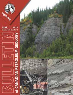
RESERVOIR ISSUE 10 • NOVEMBER 2016 31 NEW ISSUE OF THE BULLETIN Check out the newest issue of the CSPG Bulletin of Canadian Petroleum Geology online today at www.cspg.org BASIC RESERVOIR CHARACTERIZATION AND UNDERSTANDING OF BITUMAN & HEAVY-OIL RESOURCE DEVELOPING AND EMERGING BITUMEN/HEAVY-OIL DEPOSITS ADVANCES IN RESOURCE/RESERVOIR CHARACTERIZATION & RECOVERY TECHNOLOGIES ISSUES & GEOSCIENCE CONTRIBUTIONS REGARDING SUSTAINABLE DEVELOPMENT SPECIAL ISSUE: Oil-sands and heavy-oil deposits: Local to global multidisciplinary collaboration Topics Include:

The 2017 Mountjoy Conference , sponsored by SEPM (Society for Sedimentary Geology) and CSPG (Canadian Society of Petroleum Geologists), will be held the week of June 26-30, 2017 in Austin, Texas, at the University of Texas Learning Commons and the Bureau of Economic Geology Core facility. With the theme “Characterization and Modeling of Carbonate Pore Systems,” the conference will showcase new approaches and results through oral and poster sessions as well as core workshops and fieldtrips.
The theme is broad, encompassing the:
• stratigraphic, facies and diagenetic influences on varied pore systems;
• petrographic, geochemical and visualization tools applied to enhanced characterization of pore systems, from nano- and micro-scale, to fractures and cavernous pores; and
• new approaches for modeling the origin and distribution of pore systems.
Integrated case studies from academia and industry are of particular interest.
One of the highlights of the 1st Mountjoy meeting in 2015 was the opportunity for individual discussion and interaction between the attendees and the presenters. The 2017 Mountjoy Conference will continue to stress the importance of dedicated time for discussion and one-on-one networking throughout the program.
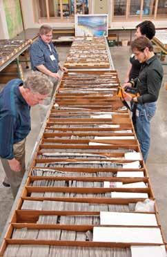
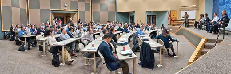
ORGANIZING COMMITTEE:
Paul (Mitch) Harris pmitchharris@gmail.com
Gene Rankey grankey@ku.edu
Don McNeill dmcneill@rsmas.miami.edu
Jean Hsieh jhsieh@repsol.com
Astrid Arts Astrid.Arts@cenovus.com
Scott Tinker scott.tinker@beg.utexas.edu
Laura Zahm LAZ@statoil.com
