


19 Geomechanics For Everyone, Part 2: The Importance of Geomechanical Data – Getting It, Understanding It and Using it Correctly 28 Go Take a Hike 30 GeoConvention 2014: Focus $10.00 OCTOBER 2013 VOLUME 40, ISSUE 9 Canadian Publication Mail Contract – 40070050


IHS AccuMa p®
Developed with extensive industry feedback, a complete user interface refresh enables easy navigation with the addition of the Microsoft® Office Ribbon and mouse-driven pan and zoom functionality. Mapping and plotting are now enhanced with editable contours, flexible postings, and transparency for all layers, including Land. Expanded engineering capability increases reservoir knowledge with both the Classic Production Graph and the new Material Balance Graph.

Gives the user so much more freedom and control over how the map works
–Geoscience Professional during a Sneak Peek of the new AccuMap®


by industry & powered by the breadth and depth of IHS
Shaped
FALL 2013 HITTING YOUR DESKTOP IHS AccuMap® learn more at ihs.com/newAccuMap A MORE POWERFUL & INTUITIVE INTERPRETATION SOLUTION THE NEW
CSPG OFFICE
#110, 333 – 5th Avenue SW
Calgary, Alberta, Canada T2P 3B6
Tel: 403-264-5610
Web: www.cspg.org
Office hours: Monday to Friday, 8:30am to 4:00pm
Executive Director: Lis Bjeld
Tel: 403-513-1235, Email: lis.bjeld@cspg.org
Event Coordinator: Kristy Casebeer
Tel: 403-513-1226, Email: kristy.casebeer@cspg.org
Geoscience Coordinator: Kelsey Green
Tel: 403-513-1225, Email: kelsey.green@cspg.org
Member Services:
Tel: 403-264-5610, Email: membership@cspg.org
Publications and Website: Emma MacPherson
Email: emma.macpherson@cspg.org, Tel: 403-513-1230
Co-Manager, GeoConvention 2014: Aileen Lozie
Tel: 403-513-1227, Email: aileen.lozie@cspg.org
Database Administrator and Accounting: Kasandra Amaro
Maternity leave until January 2014
Corporate Sponsorship: Lis Bjeld
Tel: 403-513-1235, Email: lis.bjeld@cspg.org
Controller: Eric Tang
Tel: 403-513-1232, Email: eric.tang@cspg.org
EDITORS/AUTHORS
Please submit RESERVOIR articles to the CSPG office. Submission deadline is the 23rd day of the month, two months prior to issue date. (e.g., January 23 for the March issue).
To publish an article, the CSPG requires digital copies of the document. Text should be in Microsoft Word format and illustrations should be in TIFF format at 300 dpi., at final size. For additional information on manuscript preparation, refer to the Guidelines for Authors published in the CSPG Bulletin or contact the editor.
Technical Editors
Hugh S. Mosher Colin Yeo (Assistant Tech. Editor) Nunaga Resources Ltd. Encana Corporation M.: 403-809-9997 Tel: 403-645-7724
Email: hsmosher@telus.net Email: colin.yeo@encana.com
Coordinating Editor
Emma MacPherson, Publications Coordinator, CSPG Tel: 403-513-1230, emma.macpherson@cspg.org,
ADVERTISING
Advertising inquiries should be directed to Emma MacPherson, Tel: 403-513-1230 email: emma.macpherson@cspg.org. The deadline to reserve advertising space is the 23rd day of the month, two months prior to issue date.
The RESERVOIR is published 11 times per year by the Canadian
Additional copies of the RESERVOIR are available at the CSPG office. No official endorsement or sponsorship by the CSPG is implied for any advertisement, insert, or article that appears in the Reservoir unless otherwise noted. All submitted materials are reviewed by the editor. We reserve the right to edit all submissions, including letters to the Editor. Submissions must include your
and
RESERVOIR ISSUE 9 • OCTOBER 2013 3 OCTOBER 2013 – VOLUME 40, ISSUE 9 ARTICLES Geomechanics For Everyone, Part 2: The Importance of Geomechanical Data –Getting It, Understanding It and Using It Correctly ........................................................ 19 Go Take A Hike 28 GeoConvention 2014: Focus 30 DEPARTMENTS Executive Comment .................................................................................................................. 5 Technical Luncheons 8 Division Talks ........................................................................................................................... 15 Rock Shop .................................................................................................................. 14, 25, 30
age occur
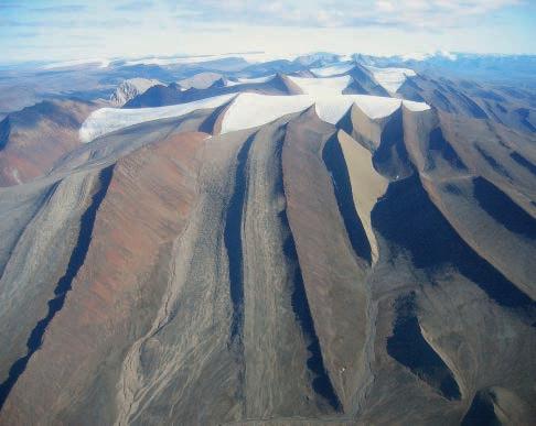
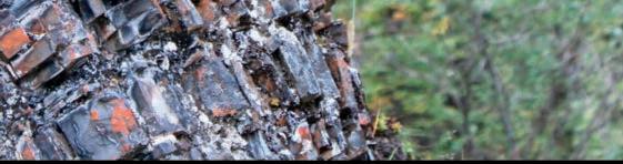
FRONT COVER
Resistant, brown-weathering, diabase sills of Early Cretaceous
within
the more recessive, dark grey, marine shales of the Blaa Mountain Group of Middle and Late Triassic age, Blue Mountains, northwest Ellesmere Island, Nunavut
Photo by Ashton Embry.
Society of Petroleum Geologists. This includes a combined issue for the months of July and August. The purpose of the RESERVOIR is to publicize the Society’s many activities and to promote the geosciences. We look for both technical and non-technical material to publish. Additional information on the RESERVOIR’s submission guidelines can be found at http://www.cspg. org/publications/pubs-reservoir-submissions.cfm. The contents of this publication may not be reproduced either in part or in full without the consent of the publisher.
equations,
desired results.
may
inaccurate
may vary
standard measurements.
expressly
liability
the acts,
any third-party user
contained in this publication. Under no circumstances shall the CSPG
its officers, directors, employees,
agents be liable for any injury, loss, damage, or expense arising in any manner whatsoever from the acts, omissions, or conduct of any third-party user. Designed and Printed by The Data Group of Companies, Calgary, Alberta.
name, address,
membership number (if applicable). The material contained in this publication is intended for informational use only. While reasonable care has been taken, authors and the CSPG make no guarantees that any of the
schematics, or devices discussed will perform as expected or that they will give the
Some information contained herein
be
or
from
The CSPG
disclaims any and all
for
omissions, or conduct of
of information
and
and
(You may never return to the o ce)

Now, get geoLOGIC’s value-added data almost any place, any time, any way you want it. Available through gDCweb on your tablet, smartphone or computer.
With 30 years of data experience behind it, gDC is the source for high quality, value-added well and land data from across Western Canada and the Northern United States. Another plus – our data is accessible through an expanding range of industry software utilizing our own easy-to-use gDC GIS and our geoSCOUT software.
View, search, import and export well, land and production data, documents, logs and more from almost anywhere. For more information visit our website at www.geoLOGIC.com
Leading the way with customer-driven data, integrated software and services for your upstream decision-making needs.
geoSCOUT | gDC | petroCUBE at www.geoLOGIC.com
Warning:
data has gone mobile
Our


CSPG EXECUTIVE
PRESIDENT
Paul MacKay • Shale Petroleum Ltd. paul.mackay@shalepetroleum.com Tel: 403.457.3930
PRESIDENT ELECT
Dale Leckie • Nexen Inc. daleleckie@nexeninc.com Tel: 403.613.0458
PAST PRESIDENT
Robin Mann • AJM Deloitte rcmann@deloitte.ca Tel: 403.648.3210
FINANCE DIRECTOR
Samantha Etherington • Barrick Energy SEtherington@barrick-energy.com Tel: 403.386.6459
FINANCE DIRECTOR ELECT
Gord Stabb • Durando Resources Corp. gstabb@durando.ca Tel: 403.819.8778
DIRECTOR
Dave Russum • AJM Deloitte drussum@deloitte.ca Tel: 403.648.3228
DIRECTOR
Alexis Anastas • Nexen Inc. alexis_anastas@nexeninc.com Tel: 403.699.4965
DIRECTOR
Mike Seifert • Canadian Discovery mseifert@canadiandiscovery.com Tel: 403.269.3644
DIRECTOR
Weishan Ren • Statoil Canada Ltd. wren@statoil.com Tel: 403.724.0325
DIRECTOR
Curtis Evans • ERCB curtis.evans@ercb.ca Tel: 403.297.8386
DIRECTOR
Dawn Hodgins • Imperial Oil Resources dawn.hodgins@exxonmobil.com Tel: 403.232.5931
DIRECTOR
Andrew Fox • MEG Energy Corp. andrew.fox@megenergy.com Tel: 403.770.5345
E XECUTIVE DIRECTOR
Lis Bjeld • CSPG lis.bjeld@cspg.org Tel: 403.513.1235
EXECUTIVE COMMENT
A message from 2013 Outreach Director, Dawn Hodgins

2013 Fresh Start and New Beginnings for Outreach
September is the time of fresh starts and revived vigour. As students head back to the class rooms to face the next year’s challenges, so does the Outreach Division of the CSPG. Outreach has taken a well deserved summer holiday but also took some time to reflect on last year’s achievements and brainstormed on how to make our programs that much better.
For those of you unfamiliar with the Outreach Portfolio, it is an important cornerstone to the CSPG. It’s the group of volunteers who work tirelessly on 3 key programs/ committees whose key mandate is to expose students and the general public to concepts of petroleum earth sciences. Each year significant funds and volunteer hours are applied to the Outreach Portfolio to ensure our flagship programs are successful in the hopes of attract the next generation of bright enthusiastic petroleum geoscientist. Our three key programs are SIFT, University Outreach and the Honorary Address, but we also have a few other ideas up our sleeves that we would love to see get off the ground.
The Student Industry Field Trip (SIFT) is the CSPG’s flagship student program that was initiated in 1978. Each year, we hold a competition that allows one top student from each university across Canada, that offers an earth sciences degree, to attend the SIFT program. This is a 2 week intense course hosted in Calgary in early May (this year May 4th-16th 2014). These students attend lectures by industry leaders on key petroleum topics, attend two field trips, and participate in a 2-week long petroleum game terminating in final presentations to a panel of industry judges. For interested parties (both student and oil & gas companies) we also coordinate a summer employment program. Many companies take this opportunity to hire one or more of these bright students for the summer and potential future permanent hires. If you are interested in hiring a student for the summer, please contact the CSPG main office.
Our second key program is the University Outreach program. This committee’s primary goal is to develop and strengthen relationships with universities, students and professors. There are many many students who are interested in the petroleum industry but have not had the exposure. The UO committee is focused on bringing petroleum geology and the CSPG brand to their doorstep. The UO team provides financial support and committee volunteers to each of the 5 major student conferences (Atlantic Universities Geosciences Conference AUGC; Western Intra-University Geosciences Conference WIUGC; Applied Earth Science Research Conference AESRC; Jeaux de la Géologie; and Alberta Student Energy Conference ASEC). The committee also coordinates the Fall and Spring Lecture Tour series, where a CSPG volunteer visits two to five Canadian earth science departments to give a technical talk to 3rd and 4th year students. Many universities are already contacting us to set up this year talk series because they are so well received. We are always looking for new speakers so please contact us if you would like to join the team.
Last but not least we also have a program in place to reach out to the general public and that is our Honorary Address program. Every fall, this program brings one or two speakers involved in the earth sciences to speak with a general audience. Last year we brought in Dr. Trent Rehill who spoke about oil exploration in Africa and Dr. Ian Tattersall, an anthropologist from the American Museum of Natural History. Our goal is to grow the HA program into a larger evening program to further promote the CSPG but also the CSPG Education Trust Fund which is the main financial source for our student programs. We are taking the fall of 2013 off to re-tool this program to bring it back bigger and better for 2014. If you would like to get in on the ground floor (Continued on page 7...)
RESERVOIR ISSUE 9 • OCTOBER 2013 5


Topics include
•Seven paradigms of data integration in reservoir modeling
•Multi-scale reservoir characterization and history matching within a probabilistic framework
•Current bottlenecks in geomodeling workflows and ways forward
•Strategies for modeling with multiple-point simulation algorithms
•Optimization of SAGD process accounting for geological uncertainties using proxy models
•Integrated shale gas study workflow


Canada’s Energy Geoscientists Available Online: www.cspg.org Office: 110, 333 - 5th Ave SW Price Member: $60.00 +GST Non - Member: $75.00 +GST
CORPORATE SPONSORS
DIAMON D
GeoLOGIC Systems Ltd.
PLATINUM
APEGA
Cenovus Energy
ConocoPhilips Canada
Nexen
GOLD
Devon Energy Corp.
IHS
Imperial Oil Ltd.
PLS
Shell Canada Limited
Statoil
SILVER
Arc Resources
Athabasca Oil Corporation
CNRL
C SEG Foundation
C SPG Educational Trust Fund
Encana Corporation
Enerplus
EOG Resources
LED Signs
MEG Energy Corp.
Roke Technologies Ltd.
TAQA North Ltd.
BRONZE
AGAT Laboratories
Apache Canada
Husky Energy Inc.
Loring Tarcore
Poggenpohl
RIGSAT Communications
RPS Energy
Schlumberger Canada Limited
Sensor Geophysical Ltd.
Suncor Energy
Talisman Energy
As of September 2013
A Special Thanks to
Geologic Systems Ltd.,
C SPG ’s Top Sponsor of the Month
(...Continued from page 5)
of this exciting program, please contact the CSPG office.
Many ideas float around year after year on how to promote our industry to not only the university students but also to the next generation behind them. Our counterparts at the CSEG have a strong program focused on elementary through junior high school children. But we would like to tap into the senior high school programs and connect with the students where they are on the brink of deciding which career path to take. One of our ideas is to make a connection with students in their science classes and show them how those basic sciences (physics, chemistry, biology and mathematics) are the fundamental basis to our beloved applied

earth science. But we need volunteers who are interested in building this generational bridge to come forward and help as a CSPG volunteer.
The Outreach Portfolio relies on the hard work and dedication of its volunteers to ensure all the programs I’ve described here are successful. The list of volunteers is very lengthy and ever growing and it’s impossible to list them all in the article. So on behalf of the Outreach Directors and the CSPG, I would like to extend a very heartfelt and appreciative thank-you to all our hard workers in the SIFT program, University Outreach, and Honorary Address program in the promotion of the Canadian Petroleum Geosciences.


When time is money, Wellsite Geoscience is money well spent.
Whether you’re exploring a basin, producing a well or completing a shale play, time is money. That’s why Weatherford Laboratories brings a suite of formation evaluation technologies right to the wellsite. Utilizing mud gas and cuttings, these technologies provide detailed data on gas composition, organic richness, mineralogy and chemostratigraphy in near real time. As a result, operators now have an invaluable tool to assist with sweet spot identification, wellbore positioning, completion design and hydraulic fracturing. We call it Science At the Wellsite. You’ll call it money well spent.
SCIENCE AT THE WELLSITE ™
RESERVOIR ISSUE 9 • OCTOBER 2013 7
©2013 Weatherford. All rights reserved Formation Evaluation ┃Well Construction ┃Completion ┃Production WELLSITE GEOSCIENCE SERVICES
www.weatherfordlabs.com
TECHNICAL LUNCHEONS OCTOBER LUNCHEON
Sedimentology, Ichnology and Sequence Stratigraphy of the Lower Cambrian Gog Group, Southern Rocky Mountains, Canada
SPEAKER
Dr. Patricio Desjardins Shell Exploration
11:30 am
Tuesday, October 22nd, 2013
Calgary, TELUS Convention Centre, Macleod Hall C/D
Calgary, A lberta

Please note: The cut-off date for ticket sales is 1:00 pm, three business days before event. (Thursday, October 17th, 2013). CSPG Member Ticket Price: $45.00 + GST. Non-Member Ticket Price: $47.50 + GST.
Each CSPG Technical Luncheon is 1 APEGA PDH credit. Tickets may be purchased online at https:// www.cspg.org/eSeries/source/Events/index.cfm.
Shallow-marine sandstone of the Gog Group in the southern Rocky Mountains comprise part of the vast terrace of siliciclastic deposits that rimmed the continental margin of western Canada, indeed almost contiguously around Early Cambrian Laurentia. It lies at the base of one of the thickest Cambrian sections in
Expertise in Integrated Subsurface Solutions
DATA ROOM SERVICES


Webcasts sponsored by

the world and records the initial phases of the early Paleozoic transgression onto the craton. Seemingly monotonous, and perhaps for this reason it has escaped detailed study, the Gog Group is revealed to consist of a more varied lithology than hitherto appreciated. Continuous sedimentary successions without major interruptions provide an instructive opportunity to trace depositional evolution of the broad shelf setting in this region. Lithologic variations, sedimentary structures and trace fossils in the Gog Group have only been previously documented at reconnaissance level.
This presentation will lay out the revised lithostratigraphy of the Gog Group in the Bow Valley region. Sequence stratigraphy aspects of the Gog Group will be discussed, focusing on the forced-regressive tidal flats. Finally a new integrated sedimentologic–ichnologic model for tide-dominated sandbodies will be discussed with the proposal of a new classification of subtidal sandbodies.
The detail study of the Gog Group have “awakened a giant” as it were, and its most likely that these rock will play in the near future a major role in our understanding of tidedominated shallow-marine systems.
BIOGRAPH Y
Dr. Patricio Desjardins is the 2011 recipient of the CSPG Best Ph.D. thesis award for his thesis entitled “Sedimentology, Ichnology and Sequence Stratigraphy of the Lower Cambrian Gog Group, Southern Rocky Mountains, Canada,” supervised by Drs. Luis A. Buatois, Brian R. Pratt and M. Gabriela Mángano at the University of Saskatchewan in Saskatoon.
Patricio graduated in 2005 as a Geologist from the Universidad Nacional de Tucumán in Argentina and continued his graduate studies as a PhD student at the University of Saskatchewan. While in Argentina he conducted research in the Upper Palozoic Tupe Formation of the Paganzo Basin analyzing the sedimentology, ichnology and sequence stratigraphy of postglacial transgressions in Gondwana. As a student Patricio has received several awards including Best Geology Graduate Award from Universidad Nacional de Tucumán, the University of Saskatchewan’s Appel Global Citizenship Awards and the named Saskatchewan Science Network (SSN) Scientist of the Month, both in from in recognition for outstanding volunteer contributions to science education in Argentina and Canada.
Today, Patricio works as a Specialist Geologist for Shell Exploration and Production Company in Houston, Texas focusing on the description and interpretation of cores from mainly unconventional reservoirs from several basins around the globe. Before his current assignment in Shell, he worked in Deep Water Gulf of Mexico, and Onshore US New Ventures and Business Development.
8 RESERVOIR ISSUE 9 • OCTOBER 2013
GEO-RESERVOIRSOLUTIONS.COM A division of Geo-Reservoir Solutions Ltd. Your data will be carefully managed on secure workstation and made available to reviewers in one of our spacious, private and comfortably appointed data rooms. If you desire to establish a data room on your own site, we can supply a dedicated workstation with working software license to you on a rental basis, which we will manage and maintain.
us for further information and pricing.
Contact
We offer seismic project preparation, data presentation on Seisware, Kingdom or WinPics seismic workstation. storage support convenience comfort
403.777.0008 info@geo-reservoirsolutions.com Featuring one of our many technical services offering world class geophysical data support ... RESERVOIR_GEORes_third_Dataroom_08_2013.indd 1 2013-08-22 1:25 PM
TECHNICAL LUNCHEONS OCTOBER LUNCHEON
Detrital Zircon signatures in the Cambrian of Northern Canada
SPEAKER
Thomas Hadlari
Geological Survey of Canada
11:30 am
Wednesday, O ctober 2nd, 2013
C algary, TELUS Convention Centre, Macleod Hall C/D
C algary, A lberta
Please note: The cut-off date for ticket sales is 1:00 pm, three business days before event. (Thursday, September 26, 2013). CSPG Member Ticket Price: $45.00 + GST. NonMember Ticket Price: $47.50 + GST.
Each CSPG Technical Luncheon is 1 APEGA PDH credit. Tickets may be purchased online at https://www.cspg.org/eSeries/source/Events/ index.cfm.
New detrital zircon U-Pb age spectra are representative of two distinct sediment sources for locally sourced Cambrian strata of northwest Canada. Compilation of published detrital zircon ages from Cambrian and Neoproterozoic strata, filtered at 5% discordance and sorted based on those two age spectra, indicate remarkable provenance consistency across northern Laurentia. Widespread distribution of those two sources is attributed to:
(1) similar crust forming events of the Archean cratons and Paleoproterozoic orogens at the core of Laurentia; and
(2) post-orogenic uplift of the Grenville orogen and pancontinental sediment dispersal of Mesoproterozoic grains, prior to mid-Neoproterozoic rifting of the supercontinent Rodinia that led to the break out and drift of Laurentia.
The rift to drift phase provided negligible sources of detrital zircon to Cambrian strata. The synthesized detrital zircon age
data are used as reference spectra for Cambrian passive margins of Laurentia for comparison with, and confirmation of, exotic ages such as the 700-500 Ma zircon grains found within the Devonian clastic wedge of northern Canada.
BIOGRAPH Y
Thomas Hadlari received a B.Sc. geology degree from the University of Saskatchewan in 1998. His Ph.D. thesis on sequence stratigraphy and basin tectonics of a Proterozoic rift basin was
Webcasts sponsored by
completed at Carleton University in 2005. He worked as a stratigrapher at the Northwest Territories Geoscience Office between 20062009 studying Phanerozoic stratigraphy of the northern Mackenzie Mountains. Since joining the Geological Survey of Canada in 2009 he has expanded that work to cover the northern Canadian mainland and Arctic Islands.


RESERVOIR ISSUE 9 • OCTOBER 2013 9
PetroFecta® from Fluid Inclusion Technologies is a unique approach combining XRF (PDQ-XRF ®), Trapped Fluid Analysis (FIS ®), and High Resolution Photography (RockEye ®) of the entire wellbore from well cuttings or core samples of any age. All analyses are conducted on the same 1 gram sample (up to 575 samples per well) with an analytical cycle of four days. Data provided on a DVD with previewer software. Information about PetroFecta ® and the umbrella of FIT services, call 918.461.8984 or visit www.fittulsa.com
TECHNICAL LUNCHEONS NOVEMBER
Holocene sediments of the Rhine-MeuseScheldt
estuaries as aids to interpret tidal and fluvial-tidal deposits in outcrop and core
SPEAKER
Dr. Allard W. Martinius Statoil Canada Ltd., Calgary
11:30 am
Tuesday, N ovember 05, 2013
C algary, TELUS Convention Centre Macleod Hall C/D
C algary, A lberta
Please note: The cut-off date for ticket sales is October 31st, 2013 at 1:00 pm, three business days before event. CSPG Member Ticket Price: $45.00 + GST. Non-Member Ticket Price: $47.50 + GST.
Each CSPG Technical Luncheon is 1 APEGA PDH credit. Tickets may be purchased online at https://www.cspg.org/eSeries/source/Events/ index.cfm.
Despite enormous technological and statistical advances, the building of subsurface static and dynamic models at various scales, and for various purposes, will always be demanding. Moreover, it is imperative that uncertainty is handled appropriately, especially as remaining reserves are increasingly found in smaller and/or more complicated reservoirs and undrained compartments.
One way of reducing information loss is to incorporate complementary data into the interpretation of subsurface core data sets and then build geomodels based on this information. To achieve this, geologists must continue to study modern and ancient analogues archiving their findings in a systematized ‘library’ (qualitative, quantitative and conceptual). Such a library should capture
(Continued on page 12...)
Webcasts sponsored by
RESERVOIR ISSUE 9 • OCTOBER 2013 11
LUNCHEON
(...Continued from page 11)
the natural variability of environments, and include methodologies for estimating and reducing subsurface uncertainty. More generally, such documentation will aid the development of conceptual depositional models, (sequence) stratigraphic correlation methods, and the construction of quantitative subsurface 3D models suitable for reservoir simulation. As such, it contributes to the

SOFTWARE

reservoir characterization work flow. This collective understanding and information can also be used for training purposes.
This presentation will address three issues in particular surrounding the aforementioned discussion:
2. The uncertainty attached to the application of modern and ancient analogues to hydrocarbon-related core studies;
3. The role of outcrop analogue studies in reservoir characterization, geomodeling, and the dynamic behavior of small-scale heterogeneities.
1. The often inadequately addressed links between sedimentary structures, the depositional processes that generated them, and the environmental conditions in which they were deposited;

12 RESERVOIR ISSUE 9 • OCTOBER 2013
TM A DIVISION OF CANADIAN DISCOVERY LTD.
BY INTERPRETERS Sound QI introduces qi-ProTM, software for interactive multi-attribute classification. Overlay seismic attributes onto rock physics analyses to interactively classify seismic volumes. For more information contact Canadian Discovery Ltd. Laurie Bellman E. lbellman@canadiandiscovery.com Armin Schafer E. aschafer@canadiandiscovery.com www.sound-qi.com T. 403.269.3644 Available November 2013
FOR INTERPRETERS,
The primary aim of this presentation is to establish a way of seamlessly transferring information from modern depositional systems to analogous depositional systems revealed in outcrop to analogous subsurface systems revealed only in core.
In the second half of the last century a number of pits were made in the estuaries of the southwestern Netherlands for the construction of large engineering works. These temporary pits opened up a unique opportunity to study subtidal deposits in considerable detail and link them to their well-known hydrographic background. These exposures revealed a variety of exceptionally well-preserved fluvial, tidal and transitional fluvial-tidal sediments. Their interpretation was facilitated by the environmental background of the Holocene deposits, which has been reconstructed from historical and recent hydrographic maps and measurements of river flow and tides (some of the records go back several centuries).
A number of examples are given of characteristic (and in some cases diagnostic) sedimentary structures. The examples come from inshore tidal environments and tidallyinfluenced river channels subject to micro-
to mesotidal conditions and comparable to known Pliocene to Modern examples taken from the Rhine-Meuse-Scheldt coastal plain. Subsequently, the Rhine-Meuse-Scheldt system was used as a standard of reference and a comparator for worldwide ancient outcrop analogues believed to cover a similar range of natural variability. The information obtained from the recent exposures and, to some extent, the outcrop analogues was finally applied to the interpretation and modeling of subsurface core data from the Norwegian Continental Shelf to illustrate a variety of analogous and comparable tidal facies and sedimentary structures encountered in prospective Late Triassic to Jurassic sedimentary systems.
One of the most striking and possibly humbling revelations to emerge from this work is that only a small proportion of information on modern systems and ancient outcrop analogues is useful for interpreting subsurface core data. The reason for this is that the recognition of many criteria requires a much larger surface area than that afforded by cores whose average diameters are about 10-12 cm.
The case studies provide sedimentologists and reservoir geologists with criteria,
GEOEDGES INC.
& Williston Basin Geological Edge Set
US / Appalachian Basin Geological Edge Set North American Shales Geological Edge Set Detailed and accurate geology at your fingertips in Petra, GeoGraphix, ArcGIS, AccuMap, GeoScout and other applications
Texas & Midcontinent US Geological Edge Set
static and dynamic models and a library of examples which can be used to understand better the spatial distribution and character of reservoir heterogeneities. Key challenges in reservoir modeling are to simulate reservoir behavior as accurately as possible while minimizing associated uncertainties. In combination with other tools, small-scale heterogeneity modeling can help to quantify reservoir uncertainty and mitigate geologic and economic risk.
BIOGRAPH Y
The main expertise of Allard Martinius is in clastic facies analysis, sedimentology and sequence stratigraphy of fluvial and shallow marine deposits, as well as in clastic reservoir characterisation and geomodelling. He participated in and led long-term research projects at Statoil’s research centre. Martinius has experience from the Norwegian continental shelf, heavy oil development projects in the Faja Petrolifera del Orinoco and the Canadian oil sands, and enjoys running field courses. He has been involved in numerous projects at appraisal, develop¬ment, and production scales in Norway as well as internationally.
Western Canada: Slave Point, Swan Hills, Leduc, Grosmont, Jean Marie, Horn River Shales, Elkton, Shunda, Pekisko, Banff, Mississippian subcrops and anhydrite barriers in SE Sask., Bakken, Three Forks, Montney, Halfway, Charlie Lake, Rock Creek, Shaunavon, BQ/Gething, Bluesky, Glauconitic, Lloyd, Sparky, Colony, Viking, Cardium, Horseshoe Canyon and Mannville CBM, Oilsands Areas, Outcrops
US Rockies & Williston: Red River, Mississippian subcrops & anhydrite barriers (Bluell, Sherwood, Rival, etc), Bakken, Three Forks, Cutbank, Sunburst, Tyler, Heath, Muddy, Dakota, Sussex, Shannon, Parkman, Almond, Lewis, Frontier, Niobrara, Mesaverde shorelines, Minnelusa, Gothic, Hovenweep, Ismay, Desert Creek, Field Outlines, Outcrops
Texas & Midcontinent: Permian Basin paleogeography (Wolfcampian, Leonardian, Guadalupian), Granite Wash, Mississippian Horizontal Play, Chat, Red Fork, Morrow, Sligo/Edwards Reefs, Salt Basins, Frio, Yegua, Wilcox, Eagleford, Tuscaloosa, Haynesville, Fayeteville-Caney, Woodford, Field Outlines, Outcrops, Structures
North American Shales: Shale plays characterized by O&G fields, formation limit, outcrop, subcrop, structure, isopach, maturity, stratigraphic cross-sections. Includes: Marcellus, Rhinestreet, Huron, New Albany, Antrim, Utica-Collingwood, Barnett, Eagleford, Niobrara, Gothic, Hovenweep, Mowry, Bakken, Three Forks, Monterey, Montney, Horn River, Colorado
Eastern US / Appalachia: PreCambrian, Trenton, Utica-Collingwood, Medina-Clinton, Tuscarora, Marcellus, Onondaga Structure, Geneseo, Huron, Antrim, New Albny, Rhinestreet, Sonyea, Cleveland, Venango, Bradford, Elk, Berea, Weir, Big Injun, Formation limits, Outcrops, Allegheny Thrust, Cincinatti Arch, Field outlines
Deliverables include:
-Shapefiles and AccuMap map features -hard copy maps, manual, pdf cross-sections
-Petra Thematic Map projects, GeoGraphix projects, ArcView map and layers files
-bi-annual updates and additions to mapping
-technical support
RESERVOIR ISSUE 9 • OCTOBER 2013 13
Western Canada Geological Edge Set Northern US Rockies
for
403 870 8122 email joelharding@geoedges.com www.geoedges.com
Eastern
information contact: Joel Harding at
ROCK SHOP


*Domestic & International Supervision 906, 505 6 St. SW Calgary, AB T2P-1X5 Jocelyn Lampron, P. Geol. President & CEO Wellsite Geological Supervision *Conventional Wells-Heavy Oil/SAGD *Coal Bed Methane Wells www.hopewellpetroleum.com info@hopewellpetroleum.com section ph: 403.266.3132 cell: 403.818.8549 *On & Offshore Geological Supervision www.rpsgroup.com/energy (403)263-0449 17084 Global Leaders in Wellsite Geology Serving the petroleum industry for over 25 years ■■ Conventional Vertical / Horizontal Wells ■■ Unconventional Heavy Oil / CBM Wells ■■ International WSG / Operations Geology (The name that says it all!!!) Bus 403.234.7625 800, 555 - 4 th Avenue SW, Calgary, AB, T2P 3E7 info@WellsiteGeologists.com www.WellsiteGeologists.com CHAD Data Magnetic & Gravity data for the Western Canadian Basin John W. Peirce, P. Geo. Chief Geophysicist www.chad-data.com 250.616.6914 • Domestic and International wellsite supervision • Conventional and Unconventional wells • Extensive Hz experience • Customized corporate solutions available (403) 250-3982 sales@clconsultants.ca www.clconsultants.ca 1602 – 5th St N.E. Calgary, AB T2E 7W3 Phone: 403-233-7729 www.tihconsulting.com e-mail: tih@shaw.ca T.I.H. Consulting Ltd. Geologic Well-Site Supervision Opus Training Group 403 720-9810 www.opustraininggroup.com Geology Training for the Petroleum Industry Wellsite 101
DIVISION TALKS ENVIRONMENT DIVISION
Sitting in the back yard watching the river roll by: floods and floodplain management in the public and scientific eye
SPEAKER
Éowyn Campbell Department of Geoscience, University of Calgary
12:00 N oon
Wednesday, O ctober 16, 2013 Centennial Place, West Tower 3rd Floor Conference A rea 250 – 5th St SW Calgary, A lberta
Major flooding in Calgary and surrounding areas in June 2013 created significant interest in floodplain development policies. As reclamation efforts began, frustrated homeowners demanded preemptive solutions for future floods based on flood-prevention efforts in other river basins worldwide. Just how effective are such efforts? Are there unintentional repercussions of floodprevention? Can procedures developed elsewhere be usefully applied in southern Alberta? A look at the history of floodplain development and flood-prevention or flood-mitigation procedures sheds some light on these questions. Along with the physical management of floods and floodplains goes the management of public awareness and expectations. The public understanding of flood processes does not always jive with scientific understanding, as with the infamous term “100 year flood.” This can lead to conflict between long-term infrastructure development and short-term political pressures. While geoscientists often think that educating the public is the answer to this problem, it is only one piece of the puzzle. Geoscientists need to take the time to understand the public perception of what the terms flood and floodplain mean, and
Sponsored by
where the disconnect occurs between that and the science. This understanding will allow us to provide information in a way that resonates with the public and provides policy makers with palatable solutions. Examples from Cougar Creek, Calgary, and High River will highlight the discussion.
BIOGRAPH Y
Éowyn Campbell is a geomorphologist with a particular interest in fluvial behaviour and its legal implications. Éowyn worked in Calgary as a petroleum geologist for 5 years before returning to the University of Calgary to complete an MSc pertaining to property boundaries and river movement. In addition to her own studies, Éowyn is a sessional instructor at the U of C, where she teaches scientific writing, Currently Éowyn is a PhD student in the Department of Geoscience.
INFORMATION
All lunch talks are free and open to the public. Please bring your lunch. For information or to present a talk to the Environment Division please contact Andrew Fox at andrew.fox@ megenergy.com.
RESERVOIR ISSUE 9 • OCTOBER 2013 15


Mudstone Sedimentology
Geomechanics and Natural Fracture Characterization
Petrophysics in Unconventional Reservoirs
Seismic Attributes and Microseismic Advances
Multidisciplinary Studies


Register Today at www.cspg.org Registration fees: *All registration fees include accommodation, meal package, and conference materials. Regular Registration Delegate $1400.00 CDN Speaker/Sponsor $1000.00 CDN Student/Professor $ 800.00 CDN
at kristy.casebeer@cspg.org with any questions. Canada’s Energy Geoscientists Canadian Society
Petroleum
presents:
*Please contact Kristy Casebeer
of
Geologists
October 15-17, 2013 Banff Centre, Banff Alberta Key Themes
DIVISION TALKS PALAEONTOLOGY DIVISION
The Guts of Microraptor
SPEAKER
Scott Persons
The University of Alberta
7:30 PM
Friday, O ctober 18th, 2013
M ount R oyal U niversity, Room B108
A BSTRACT
Since its discovery, the four-winged dinosaur Microraptor has remained central to debates over the origin of modern birds and the functional origin of bird flight. As such, the life habits of Microraptor have enticed much speculation, and this speculation has been frequently used to support broader theories. A new, fully articulated and nearly complete specimen of Microraptor gui provides direct evidence that the feeding ecology of Microraptor differed from all previous interpretations. In addition to well preserved keratinous
sheathes covering the claws and traces of long contour feathers originating from the forelimbs, hind limbs, and tail, the new specimen includes gut contents. The gut contents consist almost entirely of teleost fish remains. Microraptor is characterized by an absence of anterior tooth serrations, and re-examination of the dentition of Microraptor shows that the first three teeth in the dentary are strongly procumbent (leaning forward). Reduced tooth serrations and procumbent dentition are both traits common to many piscivores (fish-eaters). Combined with previous discoveries, this new evidence makes the diet of Microraptor the best sampled of any dinosaur. Microraptor was not limited to arboreal predation and appears to have been capable of successfully hunting the most common prey throughout the microhabitats of its ecosystem. Additionally, the new specimen is the largest Microraptor gui yet recorded.
BIOGRAPH Y
Scott Persons is originally from North Carolina and completed an undergraduate degree at Macalester College in St. Paul, Minnesota. He
Sponsored by
completed his Master’s degree in Evolution and Systematics from the University of Alberta in 2012 where he is presently working on his PhD program, under Dr. Philip Currie. His research interests focus on dinosaur ecology and functional morphology and on arms-racedriven macro evolutionary trends.
I NFORMATION
This event is jointly presented by the Alberta Palaeontological Society, Mount Royal University Earth Science Department, the CSPG Palaeontology Division and Cenovus Energy. For details or to present a talk in the future please contact CSPG Paleo Division Chair Philip Benham at 403-691-3343 or APS Coordinator Harold Whittaker at 403-286-0349 or contact programs1@ albertapaleo.org. Visit the APS website for confirmation of event times and upcoming speakers: http://www.albertapaleo.org/
RESERVOIR ISSUE 9 • OCTOBER 2013 17
STANLEY SLIPPER MEDAL
CALL FOR NOMINATIONS
“This pioneer and explorer in geology, engineering and natural gas technology bequeathed a fundamental knowledge, years ahead of his time and was considered by many a virtual Leonardo da Vinci of the Petroleum Industry. Slipper, our First President, deserved the honour (unbeknownst to him) of our highest award in the Canadian Society of Petroleum Geologists” (Aubrey Kerr).
e Stanley Slipper Medal is the CSPG’s highest honour.
The gold medal is presented annually by CSPG for outstanding contributions to oil and gas exploration in Canada. The contributions of the winner of this award should encompass a number of activities related to aspects of petroleum exploration. Such activities include: initiating and/or leading exploration programs, significant discoveries on new or existing exploration trends, teaching and/or training of explorationists, and involvement in and leadership within geological societies and professional organizations.
The committee is currently calling on the CSPG membership to provide additional nominations for this prestigious award. The award winner must be a CSPG member and should be able to attend the awards presentation to be held in the spring of 2014.
Please include an updated bibliography and letters in support of your nominee.
Nominations should be mailed, faxed or emailed before October 15 to:
CSPG Stanley Slipper Committee – Clint Tippett 110, 333 – 5 Ave SW Calgary, AB T2P 3B6
Email: clinton.tippett@shell.com and membership@cspg.org Phone: 403-264-5610 Fax: 403-264-5898

18 RESERVOIR ISSUE 9 • OCTOBER 2013
2012 Stanley Slipper Recipient Roger Smith
Stanley Slipper Medal
GEOMECHANICS FOR E VERYONE
Part 2: The Importance of Geomechanical Data –Getting it, Understanding It and Using It Correctly
| By Amy D. Fox, Canadian Discovery Ltd.
DEDICATION
Soon after arriving in Calgary, I was asked by a well-known reservoir engineer in town why I love “FMI” [image] logs so much (which I do) and why I want them collected in every well (which I don’t). I dedicate this article to him (you know who you are… miss you!).
T HE I MPORTANCE OF GEOMECHANICAL DATA
As mentioned in the introduction to this series published in the July/August 2013 issue of Reservoir, the rapid increase in activity in unconventional reservoirs has led to a rapid increase in the need for geomechanics to help understand them. Unfortunately since geomechanics is such a relatively small community of specialists, it is hard for us to keep up with demand. Since we can’t be everywhere at once, and we can’t clone ourselves, the least we can do is educate our non-geomechanics colleagues about what we can do and what we need to do it. The previous article in this series, which was published in the September 2013 issue of Reservoir, addressed to some extent the former. This article addresses the latter. The article also goes over some cautionary notes about using geomechanics data without truly understanding its limitations and applications. Finally, it touches on some important issues in data collection and availability.
T HE N EED FOR DATA
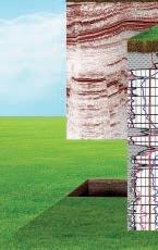
People unfamiliar with geomechanics often ask us to make geomechanical predictions without giving us a chance to look at any data other than maybe a structure map, as if being a geomechanics specialist is akin to wearing a pointy hat and carrying around a magic wand. Just like any other discipline, geomechanics needs certain types of data for a successful analysis (Chardac, et al., 2005). Here is the basic workflow: first we look at data from previously drilled wells, which allows us to constrain geomechanical parameters such as in situ stresses, and with that knowledge we can start talking about implications for drilling, completions, production, etc.
A common concern is not having any data from previously drilled wells. In almost all
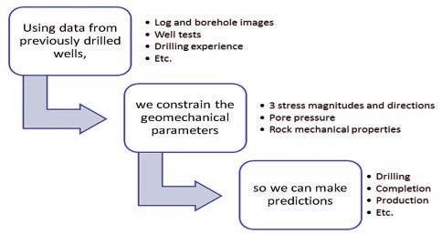
The basic (and highly simplified) geomechanics workflow.
Stress directions
Vertical stress magnitude
Minimum principal stress magnitude
Wellbore breakouts and/or tensile cracks identified in image logs (see figure), breakouts identified in oriented caliper, microseismic
Integrated density logs
Leak-off tests, minifrac/DFIT or hydrofrac data
Rock propertiesMechanical tests on core
Pore pressure
Maximum horizontal stress magnitude
Direct downhole measurements (e.g., DST, RFT), minifrac/DFIT data, drilling data (kicks, inflows)
Modeling to match stress-induced wellbore failure and/or drilling experience (see figure)
Dipole sonic, structure
Logs or seismic
Logs or seismic
Logs or seismic
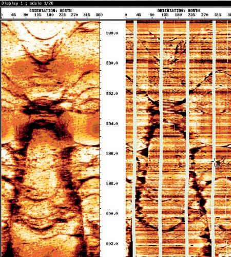
Natural fracture sets Borehole image logs (see figure) Structure, seismic
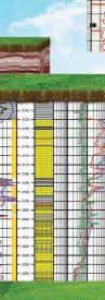
This table provides a general list of data types that are needed for constraining the geomechanical setting, including all three principal stress magnitudes and directions, formation pressures and rock properties.
cases, however, if you dig deep enough for data you didn’t realize existed and use educated guesses at parameters you can’t constrain with local data, then you can get a first-pass geomechanical model that not only allows you to do some predicting, but also helps focus your data collection efforts in new wells. In fact, data collection recommendations are frequently one of the most valuable deliverables in a geomechanics project. So what kind of data are we talking about?
KE Y GEOMECHANICAL DATA TY PES
In the race to find predictability in tight reservoirs, industry has strayed somewhat away from the tried and true sources of geomechanical data, and other sources such as seismic are increasingly being used to calculate geomechanical parameters. They should, however, be used not only with caution, but also with a proper understanding of geomechanics, which unfortunately is not the case much of
RESERVOIR ISSUE 9 • OCTOBER 2013 19
page 20...)
(Continued on
PARAMETER BEST DATA SOURCE USE WITH CAUTION
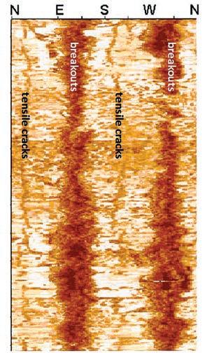
both borehole breakouts and tensile cracks. Both features are stress-induced and related to the magnitude and orientation of the principal
situ
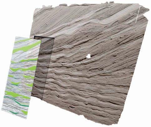
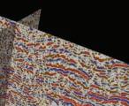
(Zoback et al., 2003, Fig. 8a) Center and right: Acoustic and electrical image showing numerous natural fractures intersecting the well. (Thompson, 2009, Fig. 5.75)
(...Continued from page 19 )
the time. For example, the fast direction in dipole sonic is often controlled by factors other than stress (Boness and Zoback, 2004). Also, calculation of horizontal stresses from logs and seismic, while common, is simply not valid in most geologic settings (Zoback, 2010). Core is necessary for reliable measurements of rock properties, and any calculated rock property values, e.g., from log or seismic data, should be calibrated to actual tests on core (Khaksar, 2009). Finally, the increasing use of log and seismic derived pore pressure was predicted fifteen years ago with strong emphasis on the limitations and geological applicability of such methods (Huffman, 1998).
Even some of the traditional types of geomechanical data can give misleading results if interpreted by someone who is not a specialist in the field. For instance, many don’t realize that the azimuth of wellbore failure (e.g., breakouts) doesn’t directly provide stress orientation if the wellbore axis is not parallel to one of the principal stresses (Peska and Zoback,
1995). In caliper analysis for breakouts, it is critical to rule out other causes of “ovality” such as washouts and key seats before coming to any conclusions about in situ stress (Plumb and Hickman, 1985; Jarosinski, 1998). And values picked off pressure-time curves from minifracs and hydrofracs are notoriously unreliable; such
data should only be interpreted by someone well-trained in that type of analysis.
One of the most important types of data that is often overlooked because one doesn’t “collect” it in a traditional sense is drilling experience. Even if not a scrap
(Continued on page 22...)
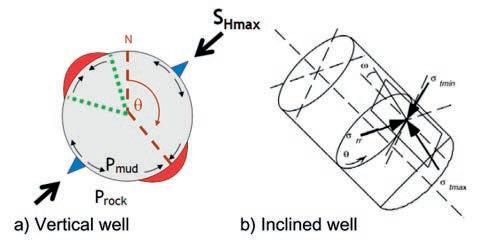
a) Position of wellbore breakouts (red) and tensile cracks (blue) in a vertical well. b) Principal stresses at the wall of an inclined wellbore. These are a function of the in situ principal stresses but require transformation to a cylindrical coordinate system. When the wellbore axis is not parallel to a principal in situ stress, the maximum stress concentration on the wellbore wall may not coincide with an in situ stress azimuth (Barton and Moos, 2004, Fig. 3).
20 RESERVOIR ISSUE 9 • OCTOBER 2013
Left: Acoustic wellbore image showing
in
stresses.
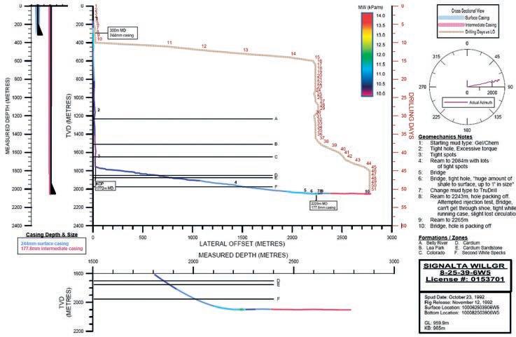
Compilation of geomechanically relevant information from drilling. Wellbore trajectory is shown as TVD vs. lateral offset on the main plot and colored by mud weight. Numbers along the trajectory refer to Geomechanics Notes to the right. Details of the lateral section are shown as TVD vs. MD in the plot below. Drilling progress is shown in the main plot as drilling days vs. lateral offset; a lack of progress is a sign of trouble, perhaps related to geomechanics. Wellbore azimuth vs. lateral offset is displayed in the stereoplot in the upper right.
(...Continued from page 20 )
of data was collected in a well, everything that went on as the well was drilled has the potential to provide clues as to what was happening geomechanically. For example, mud weights required to remediate stuck pipe or excessive cuttings tell us that the formation is probably breaking out. The shape of cavings coming over the shakers can tell us what the mode of wellbore failure is – stress-induced failure or mud penetration into pre-existing fractures. Mud weights needed to prevent kicks, inflows and gas help us determine formation pressure. Lost circulation, if caused by fracturing the rock with high mud weights, tells us about the least principal stress magnitude. A concise view of geomechanically relevant information (see figure) can often provide insight into these and other factors.
A PPLICATION-SPECIFIC DATA REQUIREMENTS
In addition to standard geomechanical data for determining the geomechanical setting, many geomechanics applications require specific types of specialized data. Since
most, if not all, of these will be discussed in upcoming articles in the series, we just provide a brief overview here and point the reader to some key references.
In enhanced recovery, geomechanics is relevant in everything from screening to abandonment (Teklu et al., 2012). In thermal operations such as SAGD and cyclic steam injection, changes are expected to occur in and around the reservoir that can have a significant impact on the geomechanics. In these cases it is important to know what that impact will be and how to include that in further modeling (Collins, 2007 and Collins, 2011). Another application involving time and reservoir changes is depletion analysis, in which changes in stress and pressure can lead to, for example, fault reactivation or solids production. Specialized lab tests can determine compaction-induced changes in porosity and permeability with depletion, while others provide input for modeling the onset and/or severity of sanding. A very important topic in Canada and elsewhere right now is reservoir containment, including caprock integrity. Caprock integrity
studies usually include highly sophisticated 3-D coupled geomechanics and reservoir engineering models that require a host of input parameters from numerous areas in addition to the basic geomechanics input (Khan, et al., 2011; Collins et al., 2011).
B ARRIERS TO DATA COLLECTION AND AVAILABILIT Y
There’s no doubt about it, data costs money, and often no matter how much we recognize that we need the data from a technical standpoint, we can’t always convince the decision-makers to spend that money. This is because data collection is generally regarded as a cost when it should be considered an investment. If collecting an image log at a cost of $10-15K and having it analyzed for a few $K more eliminates even a single non-productive frac stage that costs $100K or more, was that not a worthwhile investment? If paying even $30K on a geomechanical analysis saves a day of drilling time worth $200K, was that not a worthwhile investment?
(Continued on page 24...)
22 RESERVOIR ISSUE 9 • OCTOBER 2013
CONNECT and NETWORK with your peers, future employers, CSPG volunteers and learn how CSPG’s services and technical development programs can aide your professional development
Date: Wednesday, October 23, 2013
Location: The Libertine
Time: 4:30pm – 7:00pm

Appetizers and beverage ticket included….. FREE Register online at www.cspg.org

CONNECT and NETWORK with your peers, future employers, CSPG volunteers and learn how CSPG’s services and technical development programs can aide your professional development
Date: Wednesday, October 23, 2013
Location: The Libertine
Time: 4:30pm – 7:00pm
Appetizers and beverage ticket included….. FREE Register online at www.cspg.org
CALLING ALL YOUNG GEOLOGISTS!
CALLING ALL YOUNG GEOLOGISTS!
(...Continued from page 22)
Another reason data may not get collected is because nobody on the project team knows that they need it. Or maybe they may know they need it but are unfamiliar with the data and/or analysis and therefore order the wrong type of data. In many applications of poroelastic modeling, for example, the Biot coefficient is assumed to be equal to 1. This is a value that can actually be measured in the lab from core, but this sort of test is rarely done in practice. A good lab will interact with their client and dig down to figure what the data are needed for and then create an appropriate testing program.
Perhaps one other important barrier to collecting data can be summed up as “we tried that and it didn’t work” syndrome. Too often people who are not trained in geomechanics attempt geomechanical analyses and end up with flawed results. The experience can lead to a mistrust of the approach altogether. This, of course, is not limited to geomechanics but happens in other disciplines as well.
In Canada we have the advantage of a long-standing database of oilfield data, data that are supposed to be, and in
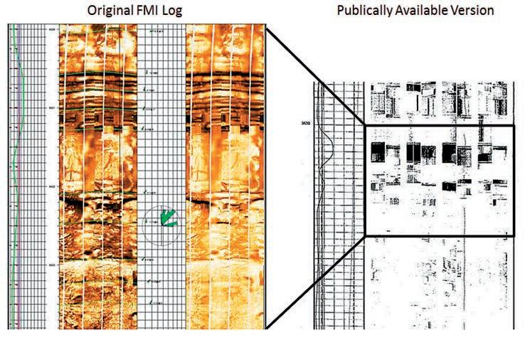
many cases are, available through public or proprietary search engines. Unfortunately several factors have combined over the years to make important data inaccessible. In some cases, the regulatory agencies are unable to enforce compliance with the data submission requirements. In other cases the issue is data format. The transition from paper logs to digital, for example, hasn’t really been accommodated, with raster images of scanned logs being the only “digital” format released to the public even when true digital logs were submitted to the regulatory agency. A prime example is wellbore image logs. Wellbore image data have been required to be submitted to the BC and Alberta energy regulatory bodies since the 1990s and mid 2000s, respectively. Before that, quite a few were submitted even without it being required simply because it went in with the rest of the logs. Back then geomechanics was a little known and highly specialized discipline and few people were using the images for it. But times have changed. Geomechanics is incredibly important now, and there’s a wealth of geomechanical information in supposedly publically available image logs. Unfortunately, in most cases the high-quality digital images are not actually
available. Copies that are available are not in a usable format, and neither the OGC nor the AER is prepared to make them so. This goes directly against the spirit if not the letter of the mandates of the regulations.
Finally, sometimes it’s not just the infrastructure that is keeping public data out of the hands of the public, but the regulations themselves. Core tests are an excellent example. In order to (understandingly) preserve core for future analysis, there are strict limitations on how many plugs can be taken, particularly for destructive testing. Getting good rock mechanics data from core, especially in heterogeneous and/ or anisotropic rock, requires several plugs of the same lithology taken at different orientations to bedding, which is impossible when you can only take, say, one plug per core box and your zone of interest in only a meter or so thick. As the industry and its needs change, regulations need to be revisited and changed if appropriate.
CONCLUSION
Acquiring geomechanical data should be considered an investment rather than a cost. It is important, however, that anyone asking
24 RESERVOIR ISSUE 9 • OCTOBER 2013
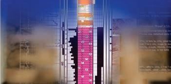
Left: Section of an FMI image in the Duvernay as submitted to the ERCB (Courtesy of HEF Petrophysical). The image shows stress induced wellbore breakouts and tensile cracks as well as significant pre-existing natural fractures. Right: Sample of the same image log in the raster format available to the public.
for geomechanics understand the types, how to properly analyze them and what their limitations are. Just like in any other discipline, when the right data aren’t available and/or the right data are misinterpreted, value is lost. In order to maximize the value of your investment in data:
DO
• Build geomechanics data and analyses into the exploration and development workflow from the very start.
• Figure out the most important data types for understanding your reservoir and drilling location.
• Have trained people analyzing the data.
DON’T
• Collect a bunch of data, store it without looking at it, pull it back out later when things aren’t going as planned.
• Collect a bunch of unnecessary data, driving up costs.
• Try “do-it-yourself” geomechanical interpretations.
ACKNOW LEDGEMENTS
The author wishes to thank HEF Petrophysical


for supplying the Duvernay FMI image, Ken Glover of Trican Geological Solutions for comments and suggestions, Sajjad Ansari of Schlumberger for useful references, and Sarah Hawkes of Canadian Discovery for her work on what we affectionately refer to as the drilling Fawkesplot.
R EFERENCES
Barton, C. and Moos, D. 2004. Geomechanical wellbore imaging: Key to managing the asset life cycle. AAPG Memoir 92, Ch. 6.
Boness, N. L. and Zoback, M.D. 2004. Stressinduced seismic velocity anisotropy and physical properties in the SAFOD Pilot Hole in Parkfield, CA, 2004, Geophysical Research Letters, v. 31, issue 15.
Chardac, O., Murray, D., Carnegie, A. and Marsden, J.R. 2005. A proposed data acquisition program for successful geomechanics projects. SPE 10.2118/93182-MS.
Collins, P.M. 2011. Geomechanical screening criteria for steam injection processes in heavy oil and bitumen reservoirs. SPE-150704-MS.
Collins, P.M. 2007. Geomechanical effects on the SAGD process. SPE-97905-PA.
Collins, P.M., Walters, D. A., Perkins, T., Kuhach, J.D. and Veith, E. 2011. Effective caprock determination for SAGD projects. CSUG/SPE 149226.
Dusseault, M. 2011. Geomechanical challenges in petroleum reservoir exploitation. KSCE Journal of Civil Engineering, v.15, p. 669-678.
Huffman, A.R. 1998. The future of pressure prediction using geophysical methods. AAPG Memoir 76, Ch. 19, p. 217-233.
Jarosinski, M. 1998. Contemporary stress field distortion in the Polish part of the Western Outer Carpathians and their basement. Tectonophysics, v. 297, p. 91–119.
Khaksar, A., Taylor, P.G., Fang, Z., Kayes, T., Salazar A. and, Rahman, K. 2009. Rock strength from core and logs: Where we stand and ways to go. SPE 121972.
Khan, S., Han, H., Ansari, S., Vishteh, M. and Khosravi, N. 2011. Caprock integrity analysis in thermal operations: An integrated geomechanics approach. World Heavy Oil Congress, Edmonton, Alberta Proceedings.
(Continued on page 26 ...)


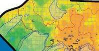
The Duvernay Project

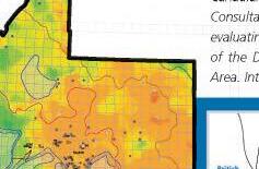

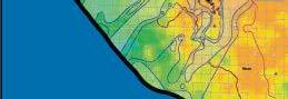


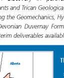


Canadian Discovery in partnership with Graham Davies Geological Consultants and Trican Geological Solutions launch a new multi-client study evaluating the Geomechanics, Hydrocarbon Systems and Geological Setting of the Devonian Duvernay Formation in the Kaybob to Willesden Green Area. Interim deliverables available December 2013.

study will include:


Implications of stress regime on drilling, completions and productivity
Hydrocarbon phase distribution and the rela tionship to geochemistry and thermal history
Characterization of the Duvernay reservoir


RESERVOIR ISSUE 9 • OCTOBER 2013 25
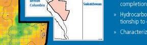
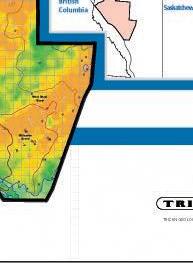
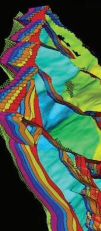
! ! " 35 35 1:600,000 Duvernay Cores (Preliminary) Duvernay Geochemistry Data (GSC, AGS) Duvernay Muskwa Isotherms (°C) Geothermal Gradient (All Units) °/1000m Structural and Geological Edges Leduc Reefs (WCSB Atlas, 1994) Duvernay Geothermal Gradient (All Units) Copyright © 2013 Canadian Discovery Ltd. All Rights Reserved. R15 R10 British ColumbiaBritish
TRICAN GEOLOGICAL SOL Canadian GRAHAM DAVIES CONSULTANTS GEOLOGICAL GDGC Subscribe now and qualify for cwright@canadiandiscovery.com | 403.269.3644 Image Left: Geothermal Gradient (All Units)
The
Peska, P., and M. D. Zoback, 1995. In situ stress and rock strength determined from observations of compressive and tensile failures in deviated boreholes: Optimizing wellbore trajectories to minimize wellbore failure. International Workshop on Rock Stress Measurements at Great Depth, Tokyo, Proceedings, p. 25–29.
Plumb, R.A., and Hickman, S.H. 1985. A comparison between the four-arm dipmeter and the borehole televiewer in the Auburn geothermal well. Journal of Geophysical Research B, v. 90, p. 5513–5521.
Qiu, K., Marsden J.R, Solovyov, Y., Safdar, M., Chardac, O. and Shatwan, M. 2005. Downscaling geomechanics data for thin-beds using petrophysical techniques. SPE 10.2118/93605-MS.
Teklu, T.W., Graves, R.M., Tutuncu, A.N., Kazemi, H. and Alameri, W. 2012. Geomechanics considerations in enhanced oil recovery, SPE 162701.
Thompson, L.B. 2009. Atlas of Borehole Imagery. AAPG/Datapages Discovery Series No. 13.
Zoback, M.D. 2010. Reservoir Geomechanics. Cambridge University Press, New York.
ROCK SHOP
Zoback, M.D., Barton, C.A., Brudy, M., Castillo, D.A., Finkbeiner, T., Grollimund, B.R., Moos, D.B., Peska, P., Ward, C.D., Wiprut, D.J.

2003. Determination of stress orientation and magnitude in deep wells. International Journal of Rock Mechanics and Mining Sciences, v. 40, p. 1049-1076.
BIOGRAPH Y
Amy earned an undergraduate degree in Geology in 1994 from the University of New Hampshire
RockWell Consulting

and a Masters in Geophysics from Stanford University in 1998. After spending six years with GeoMechanics International (GMI) in California and Houston, Amy returned to Stanford to earn a Ph.D. in Geophysics specializing in geomechanics under the guidance of Dr. Mark Zoback. She later returned to GMI, now part of Baker Hughes, and worked in Houston and Calgary. She joined Canadian Discovery in 2012 where she applies her expertise to multi-client and single-client integrated geoscience studies.
Amy has a strong interest in using geomechanics to bridge disciplines and increase knowledge of reservoir dynamics. In addition to being a technical specialist, Amy spent a few years in the world of corporate training and development and was an adjunct instructor at Bucknell University. She is a member of CSPG, CSEG, CWLS and SPE and sits on AAPG’s Education Committee.
26 RESERVOIR ISSUE 9 • OCTOBER 2013
Strip Log Strip Log Horizontal Log Horizontal Log Mud Log Mud Log Log Viewer Log Viewer Log Manager Log Manager Log Analysis Log Analysis Suite 102, 7370 Sierra Morena Blvd SW, Calgary, AB T3H 4H9 info@WellSight.com 1-800-447-1534 (403) 237-9189 petrographical & sedimentological descriptions for samples (thin section - fluid inclusion studies) conventional vertical/horizontal wells operations geology SPECIALIZED IN GEOLOGICAL WELLSITE SUPERVISION AND CORE ANALYSIS
our best friend and most valuable partner is our client Stephan C. Dragomir president www .g e ok2. c om - phon e: 403.831.9941 - s dr a gomir @ge ok2. com (...Continued from page 25)
Canada’s Energy Geoscientists
Special CSPG 1 Day Workshop
The CSPG is proud to announce a special 1 day workshop with Dr. Jurgen Schieber Description and Interpretation of Shale Facies—Dr. Jurgen Schieber
Friday October 18th, 2013—Calgary, AB
Dr. Schieber—Department of Geological Sciences, Indiana University
2013 CSPG Gussow Conference Speaker
If you are interested in this workshop and would like to register please contact Kelsey Green at the CSPG office—kelsey.green@cspg.org , p: 403-513-1225
For more information visit: www.cspg.org/education
Canada’s Energy Geoscientists
New Learning Series—Geocafé!
The CSPG is looking for Your Help!
We are looking for enthusiastic geoscientists who have an interesting topic that they would like to present and discuss with their geoscience colleagues over coffee.
Geocafé Sessions—held in the CSPG classroom with up to a dozen attendees, it’s FREE to attend and Tim Horton’s coffee and refreshments are always provided.
If you are interested in this new opportunity beginning this Fall please contact Kelsey Green at the CSPG - e: kelsey.green@cspg.org , p: 403 -513-1225
For more information visit: www.cspg.org/technical/geocafe


RESERVOIR ISSUE 9 • OCTOBER 2013 27

GO TAKE A HIKE
Preglacial channel near Heritage Ranch, Red Deer, AB
| By Jared Fath and Len Hills
Things to bring: Hiking Boots, Binoculars, Water
Expected time: 2-3 hours, round trip (South) 4.5km
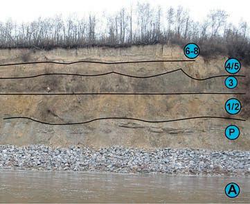
There is an excellent example of a buried pre-glacial valley in Red Deer, just off the QE II highway. Pre-glacial valleys were first observed in Western Canada by G.M. Dawson, and R.G. McConnell in the late 1800s. These were often found in cutbanks of present-day rivers. These ancient valleys are exposed in the valley walls incised in bedrock, typically of Cretaceous or Paleocene age, and covered by glacial tills. In Red Deer a deep, wide channel has been cut into Paskapoo sands and shales of Paleocene age (65-56 million years old). This channel is filled with pre-glacial (21,000 - 42,000 years old) sands and gravels and topped up by glacial and glaciolacustrine units. The basal fills of valleys like this one have historically been used for aggregate and as highyielding aquifers and contain a mid-Wisconsinan paleofauna.
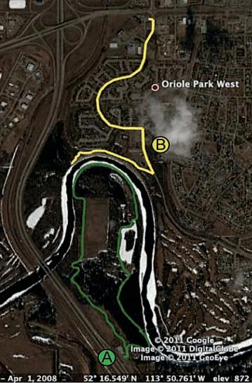
The outcrop may be accessed via Heritage Ranch or the Oriole Park West subdivision. To get an overview of the buried valley (A), park at the Heritage Ranch directly off the QEII highway. Take the footpath over the bridge and cross over onto a horse trail. Follow the horse trail to a large open field. Continue to the end of the field and turn left along one of the small horse trails branching off the large gravel horse trail. Following these trails one can reach the edge of the river and begin following the inner meander bend of the river from west to east. While on your way back you can examine an abandoned sandstone quarry on the East of the river bend. This route is fairly easy to walk, and affords many excellent views of the preglacial channel exposed on the opposite bank.
The Reservoir Committee welcomes contributions from our readership to this series. If you wish to offer a submission to Go Take a Hike on your favourite hike of geological interest, email the Reservoir at Emma.MacPherson@cspg.org for more information.
 Map of Trails: (A) Southern trail, (B) Northern outcrop trail.
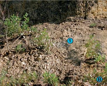
(A) View of paleochannel showing (P) Paskapoo Formation (1/2) Empress Formation gravels and sands (3) Labuma Till (4/5) occasional debris flow with Maunsell Till overlying (6-8) Glacial Lake Red Deer sediments. (B) Close-up of Empress Formation showing (1) pebble involutions into sand layer.
Map of Trails: (A) Southern trail, (B) Northern outcrop trail.
(A) View of paleochannel showing (P) Paskapoo Formation (1/2) Empress Formation gravels and sands (3) Labuma Till (4/5) occasional debris flow with Maunsell Till overlying (6-8) Glacial Lake Red Deer sediments. (B) Close-up of Empress Formation showing (1) pebble involutions into sand layer.
28 RESERVOIR ISSUE 9 • OCTOBER 2013
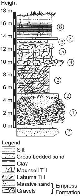
U nits
(8) Glaciolacustrine silt and clay varves with roots
(7) Ripple crosslaminated glaciolacustrine sands
(6) Red and tan glaciolacustrine clays
(5) Maunsell Till (may rest directly on Labuma below)
(4) Sand and gravel debris flow (local)
(3) Labuma Till
(2) Empress Formation sands
(1) Empress Formation Gravels
(P) Paskapoo Formation Bedrock
Alternatively (B), you can turn off the QEII at 67th street and immediately turn right at the Tim Horton’s restaurant. From the Tim Horton’s follow Orr Drive to a T-intersection at Oak Dr. Turn right at Oak Drive and follow until reaching a parking lot by a park. From there you can follow a paved path skirting the top of the cutbank turning off into a gravel path part way down in order to find a set of stairs leading down to the river path. This path allows direct access to the cutbank, however caution is advised as riprap has been placed on the cutbank to prevent erosion. This has the effect of both damaging the outcrop, and making footing quite treacherous. Nevertheless you can get some excellent closeup outcrop such as those below. This is a worthwhile trip for those interested in the glacial history of Alberta, its buried valley aquifers and Pleistocene palaeontology.
REF EREN CES:
Stalker, A.M., 1960. Surficial Geology of the Red Deer map-area, Alberta. Memoir 306, Geological Survey of Canada.
Rutter, N.W., Andriashek, L.D., and Fenton, M.M. 1998. Engineering geology of Edmonton, Alberta. In Urban Geology of Canadian Cities, GAC Special Paper 42. pp. 71-92.
Westgate, J.A. and Bayrock, L.A. 1964. Periglacial structures in the Saskatchewan gravels and sands of central Alberta, Canada, The Journal of Geology, 72: pp. 641-648.
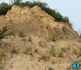
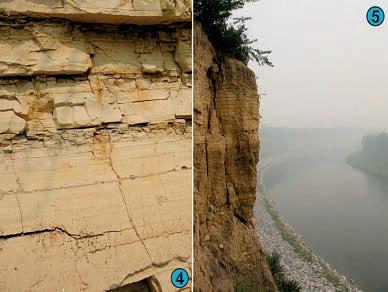 (3) Looking upward at valley-fill, glacial and glaciolacustrine sediments(4) Detail of clay and silt varves showing post-depositional root haloes. (5) Sheer cliffs of Maunsell Till and Lake Red Deer Sediments
RESERVOIR ISSUE 9 • OCTOBER 2013 29
CORPORATE SUPPORTERS
AGAT Laboratories
Apoterra Seismic Processing Ltd.
ARC Resources Ltd.
Arcis Seismic Solutions
Cabra Consulting Ltd.
Canadian Natural Resources Ltd.
CGG Veritas Services Inc.
Compass Directional Services
Continental Laboratories Ltd.
Cossack Land Services Ltd.
Crescent Point Energy Trust
Datalog Technology Inc.
Edge Technologies Inc.
Exova Canada Inc.
Explor
GeoTir Inc.
GLJ Petroleum Consultants Ltd.
IHS
Kulczyk Oil Ventures
LXL Consulting Ltd.
McDaniel & Associates Consulting Ltd.
MOH & Associates Oilfield Consultants
National Oilwell Varco
Nickpoint Environmental Services
Olympic Seismic Ltd.
Paradigm Geophysical Corp.
Pason Systems Corp.
Perpetual Energy Inc.
Pioneer Professional Group
Pro Geo Consultants
ProActive Health
Pulse Seismic
Regent Resources Ltd.
Rigsat Communications
RPS Energy Canada Ltd.
SAExploration
SeisWare
Sensor Geophysical Ltd.
Sigma Explorations Inc.
Sourcex
Total Gas Detection Ltd.
Trident Exploration Corp.
Western Geco
AS OF SEPTEMBER 10, 2013
CSPG welcomes our 2013 Corporate Supporters!
The benefits of being a corporate member include:
• Recognition in the monthly Reservoir and quarterly Bulletin
• One associate membership
• Reserved tables at the technical luncheons with your company logo
• One free pass to the CSPG Core Conference
…and more! Contact Kasandra Klein at kasandra.klein@cspg.org to be a corporate member today!
GEOCONVENTION 2014: FOCUS
May 12 - 16, 2014
| By Phil Esslinger, CSPG General Co-Chair, Laurie Weston Bellman, CSEG General Co-Chair, Nabil Al Adani, CWLS General Co-Chair
FOCUS THE E ARTH
The oil and gas industry in North America has undergone a profound realignment in the last decade due to the widespread use of horizontal drilling techniques, in particular the advent and rapid acceptance of horizontal multi-stage hydraulic fracturing in shales and tight reservoirs. These changes have been described as “revolutionary” and the multitude of successful new plays driven by these new techniques is testimony to the significant and ongoing impact of the revolution on our industry. The FOCUS 2014 GeoConvention is being designed to provide our membership with the knowledge required to adapt to these changes, the tools necessary to refine their workflows and the processes required to sustain the continuing evolution of technology in all areas of the oil and gas industry.
T ECHNICAL PROGRAMME
To this end, the 2014 GeoConvention will place great emphasis on integrated sessions attracting multi-discipline submissions relating to many of the new and established unconventional plays developing in the WCSB and around the world. In addition to our tradition of high quality integrated oral and poster presentations, focused sessions highlighting new ideas and advances in specific geoscience and business related areas are planned. Of course, the GeoConvention would not be complete without the ever
ROCK SHOP
popular Core Conference held on the Thursday and Friday during Convention week.
AN IMPORTANT A NNIVERSARY
A special session will be dedicated to celebrating the 100th anniversary of the discovery of the Turner Valley field - the beginning of the oil and gas industry in Western Canada! This event will not only celebrate the milestone, but also recognize the pioneering and innovative spirit that still defines our membership today.
N ET WORKING
The exhibition hall is always the focus of a number of networking events including the Icebreaker, held on the Monday night. Several other events are planned providing opportunities to connect with old and new friends in a comfortable environment.
A new trend in staying connected (and reducing paper) at conferences is the mobile app which was introduced to the GeoConvention in 2013. A greatly improved smartphone application for 2014 will easily allow delegates to plan and optimize their days at the convention and puts a wealth of information regarding presentations, speakers, special announcements, etc. in the palm of your hand.
Put the dates in your calendar and watch for additional articles and announcements as we progress with the FOCUS 2014 arrangements. On behalf of the organizing committee, we are very excited to plan and present the 2014 GeoConvention. Looking forward to seeing you all there in May 2014!

742 Memorial Drive NW Calgary,Alberta T2N 3C7
P: 403 242 1522 F: 403 242 8223 E: office@chinookconsulting.ca www.chinookconsulting.ca
30 RESERVOIR ISSUE 9 • OCTOBER 2013
www.geoconvention.com
SERVICES • Wellsite geological supervision • Core and cuttings petrographic studies • Operations geology • Remote geo-steering
remote geological supervision • Project
and
management
www.apega.ca
You get 5% off WestJet flights with your APEGA membership? TAkE off!
Professional Geoscientists get a lot out of an APEGA membership: peer recognition and public credibility, the right to your title, and support for the geoscience community. But did you know Professional Geoscientists also have access to valuable discounts that can save 50 per cent or more on goods and services?
• Car rentals and hotel bookings at below-market rates
• 5 per cent off WestJet business flights
• Money back on a Costco Card
• Deals on new cars and electronics

• And more for details, visit apega.ca/members/benefits/toc.html
Professionals in Geoscience


Blueback Reservoir the preferred and chosen GeoScience Solutions Partner Try something new. Find something better. Blueback Rock Physics plug-in for Petrel* Bridging the gap between geology and geophysics The complete suite of rock physics tools for quantitative interpretation across multiple domains within Petrel. Blueback Reservoir blueback-reservoir.com E sales@blueback-reservoir.com | T +1 403 538 4821 blueback-reservoir.com/rockphysics *Mark of Schlumberger 13000 Vol shl=0.2 Reservoir Properties
Seismic
Wells Petrel
