$10.00 OCOTBER 2015 VOLUME 42, ISSUE 09 Canadian Publication Mail Contract – 40070050 RETURN UNDELIVERABLE CANADIAN ADDRESSES TO: CSPG – 110, 333 - 5 Avenue SW Calgary, Alberta T2P 3B6 Addressee Additional Delivery Information Street Address Postal Box Number and Station Information Municipality, Province/Territory Postal Code 14 The Old Fort Point Formation: Redefinition and formal subdivision of a distinctive stratigraphic marker in the Neoproterozoic Windermere Supergroup, southern Canadian Cordillera 24 Go Take A Hike
CSPG OFFICE
#110, 333 – 5th Avenue SW Calgary, Alberta, Canada T2P 3B6
Tel: 403-264-5610
Web: www.cspg.org
Please visit our website for all tickets sales and event/course registrations Office hours: Monday to Friday, 8:00am to 4:30pm
The CSPG Office is Closed the 1st and 3rd Friday of every month.
OFFICE CONTACTS
Membership Inquiries
Tel: 403-264-5610 Email: membership@cspg.org
Technical/Educational Events: Biljana Popovic
Tel: 403-513-1225 Email: biljana.popovic@cspg.org
Advertising Inquiries: Kristy Casebeer
Tel: 403-513-1233 Email: kristy.casebeer@cspg.org
Sponsorship Opportunities: Lis Bjeld
Tel: 403-513-1235 Email: lis.bjeld@cspg.org
Conference Inquiries: Candace Jones
Tel: 403-513-1227 Email: candace.jones@cspg.org
CSPG Foundation: Kasandra Amaro
Tel: 403-513-1234 Email: kasandra.amaro@cspg.org
Accounting Inquiries: Eric Tang
Tel: 403-513-1232 Email: eric.tang@cspg.org
Executive Director: Lis Bjeld
Tel: 403-513-1235, Email: lis.bjeld@cspg.org
EDITORS/AUTHORS
Please submit RESERVOIR articles to the CSPG office. Submission deadline is the 23rd day of the month, two months prior to issue date. (e.g., January 23 for the March issue).
To publish an article, the CSPG requires digital copies of the document. Text should be in Microsoft Word format and illustrations should be in TIFF format at 300 dpi., at final size.
CSPG COORDINATING EDITOR
Kristy Casebeer, Programs Coordinator, Canadian Society of Petroleum Geologists
Tel: 403-513-1233, kristy.casebeer@cspg.org
The RESERVOIR is published 11 times per year by the Canadian Society of Petroleum Geologists. This includes a combined issue for the months of July and August. The purpose of the RESERVOIR is to publicize the Society’s many activities and to promote the geosciences. We look for both technical and non-technical material to publish. The contents of this publication may not be reproduced either in part or in full without the consent of the publisher. Additional copies of the RESERVOIR are available at the CSPG office.
No official endorsement or sponsorship by the CSPG is implied for any advertisement, insert, or article that appears in the Reservoir unless otherwise noted. All submitted materials are reviewed by the editor. We reserve the right to edit all submissions, including letters to the Editor. Submissions must include your name, address, and membership number (if applicable).The material contained in this publication is intended for informational use only.
While reasonable care has been taken, authors and the CSPG make no guarantees that any of the equations, schematics, or devices discussed will perform as expected or that they will give the desired results. Some information contained herein may be inaccurate or may vary from standard measurements. The CSPG expressly disclaims any and all liability for the acts, omissions, or conduct of any third-party user of information contained in this publication. Under no circumstances shall the CSPG and its officers, directors, employees, and agents be liable for any injury, loss, damage, or expense arising in any manner whatsoever from the acts, omissions, or conduct of any third-party user.
Printed by McAra Printing, Calgary, Alberta.
The Old Fort Point Formation: Redefinition and formal subdivision of a distinctive stratigraphic marker in the Neoproterozoic Windermere Supergroup, southern Canadian Cordillera 14
Correction from our September 2015 Issue. The September 29th Technical Luncheon speaker was Norka Marcano from Schlumberger Reservoir Laboratories.
FRONT COVER
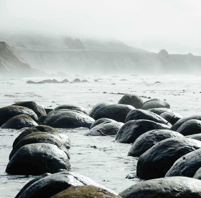
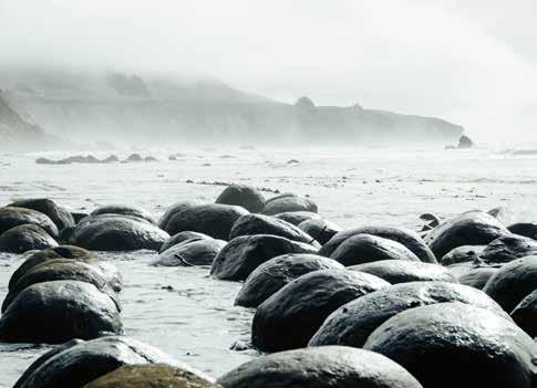
Schooner Gulch State Beach in Mendocino County. Spherical concretions form rows of ‘bowling balls’ visible at low tide. Caused by mineral cementation around a nucleation site (typically a fragment of organic material), these hardened sandstone concretions are exposed as the softer sandstones of the Galloway Formation are eroded. As the cliffs are worn back by the waves, concretions are left behind on the wave cut platform.
Photo by: Monika Silvia Enachescu
OCTOBER
VOLUME 42, ISSUE 09
2015 –
ARTICLES
Go Take A Hike .......................................................................................................................... 24 Honorary Member - Kathryn
Scales ...................................................................... 30 DEPARTMENTS Message from the Board 5 Technical Luncheons 8 Division Talks .............................................................................................................................. 10 Rock Shop .................................................................................................................................. 29
(Kathy)
RESERVOIR ISSUE 09 • OCTOBER 2015 3

Power your upstream decision-making with customer-driven data, integrated software and services from geoLOGIC.
At geoLOGIC, we help turn raw data into actionable knowledge. That’s a powerful tool to leverage all your decision making, whether it’s at head office or out in the field. From comprehensive oil and gas data to mapping and analysis, we’ve got you covered. Get all the knowledge you need, all in one place with geoLOGIC. For more on our full suite of decision support tools, visit geoLOGIC.com

geoSCOUT | gDC Upstream knowledge solutions
Knowledge
has TO BE improved, CHALLENGED, AND INCREASED constantly, OR IT vanishes.
CSPG BOARD

PRESIDENT Tony Cadrin president@cspg.org Tel: 403.303.3493

PRESIDENT ELECT
Greg Lynch • Shell Canada Ltd presidentelect@cspg.org Tel: 403.384.7704

PAST PRESIDENT
Dale Leckie pastpresident@cspg.org

FINANCE DIRECTOR
Astrid Arts • Cenovus Energy directorfinance@cspg.org Tel: 403.766.5862

FINANCE DIRECTOR ELECT
Scott Leroux • Long Run Exploration directorfinanceelect@cspg.org Tel: 403.802.3775

DIRECTOR
Mark Caplan

DIRECTOR
Milovan Fustic • Statoil Canada Ltd. publications@cspg.org Tel: 403.724.3307

DIRECTOR
Michael LaBerge • Channel Energy Inc. memberservices@cspg.org Tel: 403.301.3739

DIRECTOR
Ryan Lemiski • Nexen Energy ULC youngprofessionals@cspg.org Tel: 403.699.4413

DIRECTOR
Robert Mummery • Almandine Resources Inc. affiliates@cspg.org Tel: 403.651.4917

DIRECTOR
Darren Roblin • Kelt Exploration corprelations@cspg.org Tel: 587.233.0784

DIRECTOR
Jen Russel-Houston • Osum Oil Sands Corp. Jrussel-houston@osumcorp.com Tel: 403.270.4768

DIRECTOR
Eric Street • Jupiter Resources street@jupiterresources.com Tel: 587.747.2631

EXECUTIVE DIRECTOR
Lis Bjeld • CSPG lis.bjeld@cspg.org Tel: 403.513.1235
Message from the Board
A message from Jen Russel-Houston, Director

BYOE. Bring your own Engineer
What is in a name? When I describe a rock as “vuggy, crackle-fractured dolomudstone” my geoscience colleagues can immediately picture that rock. They can imagine the warm tropical sea that deposited the lime mud and the diagenetic and geomechanical processes that altered the rock to create the vugs and the fractures. They can picture the 3-dimensional pore system and could even estimate a porosity and permeability. A rock name means something to us, but to everyone else it is foreign secret language that is often a barrier to communication.
How often does a play or an opportunity get missed because the geoscientist and the engineer struggle to communicate? We spend years describing core and seismic volumes and present our geologic model to our team and often miss a critical step. We neglect to “translate” our work so it can be applied to solve the engineering problems. This translation step is critical to the successful application of the geoscience model and the CSPG has a few tricks to help you and your engineering colleagues break the language barrier and improve communication.
Immersion. Just like learning a language in a foreign land, immersion can accelerate language development. Working closely with your engineering colleagues on integrated teams with offices beside each other is a great way to improve the communication. The daily discussion of the methods, the
progress of the geologic evaluation, and the concerns of the engineer will ensure that the work you are doing as a geologist will be used by the engineer to optimize reservoir performance. The AAPG Annual Convention and Exhibition (ACE) will be hosted in Calgary June 19-22, 2016. As a part of ACE there will be a day dedicated to integrated presentations that are of interest to both geologists and engineers including topics such as integrated case studies, completion design, geomechanical stimulation of tight reservoirs, and reserve estimation. Hearing the same presentation with your engineering colleague will stimulate some interesting discussion at the coffee break and may reveal new insights about your shared reservoir.
Teach your engineering colleagues the language and start with the rocks. Some of the best breakthroughs I have experienced in communicating with my engineering colleagues were when we both looked at the rocks together; whether we were looking at the core, walking the shorelines of a modern depositional environment, studying the outcrop of an ancient analogue, or preferably all three. Following the three-day ACE the CSPG will host the CSPG International Core Conference June 23-24, 2016 at the Alberta Energy Regulator Core Research Centre. This is a great opportunity to bring your engineering colleagues to look at the rocks that comprise some of the most spectacular reservoirs in the world.
(... Continued on page 7)
RESERVOIR ISSUE 09 • OCTOBER 2015 5
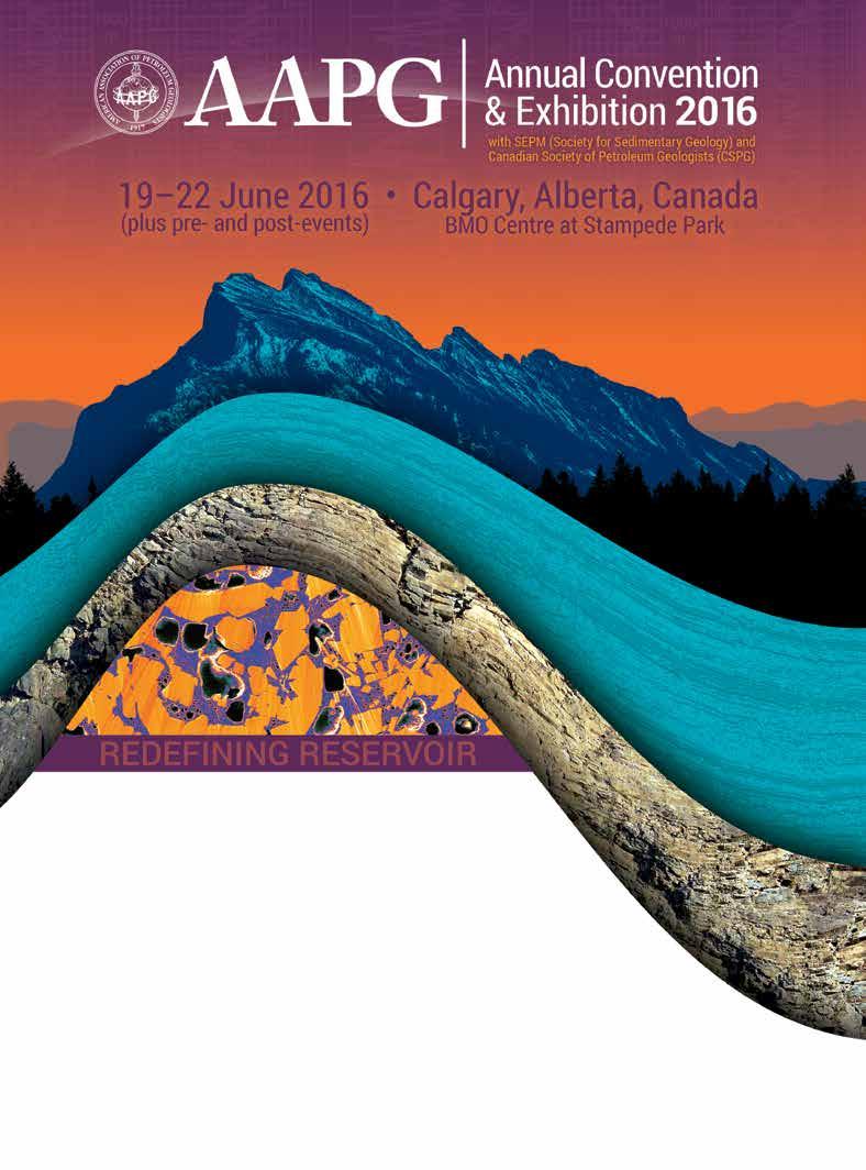
Save the Date The prestigious AAPG 2016 Annual Convention & Exhibition (ACE) returns to Calgary for the first time in a decade. Join the world's best and brightest geoscientists and energy leaders at this premier industry event. Exhibition and Sponsorship Opportunities Available. ACE.AAPG.org
CORPORATE SPONSORS
SAMARIUM
geoLOGIC systems ltd.
DIAMOND
AGAT Laboratories
CSPG Foundation
TITANIUM
Tourmaline Oil Corp.
APEGA
PLATINUM
Cenovus Energy
Imperial Oil Resources
GOLD
IHS Global Canada Limited
Suncor Energy
Nexen ULC
SILVER
Loring Tacore Labs Ltd.
Weatherford Canada Partnership
Seitel Canada Ltd.
Devon Energy Corp
Enerplus Corporation
Paradigm
Canadian Natural Resources Ltd
GLJ Petroleum Consultants Ltd.
Husky Energy Inc.
BRONZE
Chinook Consulting
Talisman Energy
Long Run Exploration
Qatar Shell GTL Limited
Osum Oil Sands Corp.
Halliburton
Pro Geo Consultants
Pengrowth Corporation
Exxonmobil Exploration Co. Ltd.
Crescent Point Energy Trust
Belloy Petroleum Consulting
Ikon Science Ltd.
Geomodeling Technology Corp.
Baker Hughes Calgary
MJ Systems
Streamsim Technologies, Inc.
As of Juky 31, 2015 A
You can teach them the language of the rocks and, in turn they can share their observations and interpretations of the reservoir with you.
and reservoir engineer can have. Through the iterations they develop a shared understanding of the reservoir and this allows them to be predictive about future reservoir performance. This conversation is improved if there is a shared language of geology from days spent looking at reservoir rocks in the core shack or in the field together. It is a conversation that is repetitive and never-ending and can be sparked anew by seeing a map on an office-mate’s wall or sharing notes at the back of a lecture hall. Through conferences, short courses and field trips the CSPG is giving you a forum to host these conversations. So, bring your engineer and see where the conversation will lead you. (... Continued from page 5)
Translate your facies models into reservoir flow units. Ultimately, I find the easiest way to communicate with my engineering colleagues is to speak their language – digits. Translating the facies model into reservoir flow units with reservoir proprieties populated in 3-dimensions is the clearest way of describing your understanding of the geology to the engineers. History matching a geomodel to production data will inevitably lead to editing some of the reservoir properties and perhaps to a new interpretation. I am always looking for ways to improve this process. GeoConvention in Calgary on March 7-11, 2016 is looking for presentations on geoscience workflows and new techniques to optimize resources. Consider sharing your methods with others and submit an abstract, or plan to attend and find out how others approach the translation of geology into resource optimization.
The iterative process of building a history-matched geomodel is the most significant “conversation” a geologist
RESERVOIR ISSUE 09 • OCTOBER 2015 7
Special Thanks to Geologic Systems Ltd., CSPG’s Top Sponsor of the Month.
CRAINʼS LOG ANALYSIS COURSES For Engineers, Geologists, Geophysicists, and Technologists Every April and Octoberin Calgary Details /Registration at www.spec2000.net/00-coursedates.htmSlide Shows, Reference Manuals, and Exercises Included AV-01 Practical Quantitative Log Analysis AV-02 Advanced Quantitative Log Analysis AV-03 Analysis of Unconventional Reservoirs Details / Order Onlineat: www.spec2000.net/00-av-training.htm Single-User, Corporate, and Academic Licenses Available Individual Reference Manuals and Slide Shows Available Separately Shareware Petrophysical Encyclopediaat www.spec2000.net 50+ Years OfExperience AtYour Fingertips === E. R. (Ross) Crain. P.Eng. 1-403-845-2527 ross@spec2000.net === ===
TECHNICAL LUNCHEONS
Marlowe Steen River
Muskeg “Stack” Oil
Discovery – And Now! For Something Completely Different
SPEAKERS
Graeme Bloy
Atum Consulting Ltd.
Gurpreet Sawhney
Strategic Oil & Gas Ltd..
11:30 am
Tuesday, October 20th, 2015 Calgary, TELUS Convention Centre Exhibition Hall D, North Building Calgary, Alberta
Please note: The cut-off date for ticket sales is 1:00 pm, five business days before event. [Tuesday, Oct. 13th, 2015]. CSPG Member Ticket Price: $45.00 + GST. NonMember Ticket Price: $47.50 + GST.
Each CSPG Technical Luncheon is 1 APEGA PDH credit. Tickets may be purchased online at www. cspg.org
ABSTRACT
The Marlowe/ Steen River Muskeg “stack” light oil discovery is located on the north and west side of the Steen River astrobleme structure in northern Alberta. OOIP for this discovery is estimated at 2.5 - 4 billion barrels of oil, over a 300,000 acre area, net oil pay is up to 30 feet thick. This reservoir occurs approximately 45 feet below the top of the Muskeg Fm., in a distinctive 80 foot thick carbonate/evaporite package which is correlative over a 30 by 15 mile area. The Muskeg “stack” oil production was recognized early in the Keg oil wells drilled on the outer rim the Steen River structure but performed poorly in vertical/directional well completions.
To date 19 horizontal wells have been drilled in the “stack”, and are multi-stage frac’d, currently producing at approximately 1750 boepd. Decline analysis on per well basis shows the expected EUR is 274 Mboe with an IP30 of 291 boepd. There are at least 800 more locations to drill on this play. Discussion of the development plan shows the significant capital outlay to bring this project on full production.
This discovery demonstrates the potential of low permeability Devonian carbonate reservoirs in the WSCB.
BIOGRAPHIES
Graeme Bloy is a geoscience advisor (consultant) at Strategic Oil & Gas. He is currently the President
of Atum Consulting Ltd., a private company providing geoscience expertise (carbonate) at a variety of different technical levels, from prospect generation to managing geo-modelling projects. Graeme has held a variety of geoscience/management positions with Canada Capital Energy Ltd.,West Energy Ltd., Devon Canada, Anderson Oil & Gas, Ulster Petroleums and Startech Energy Ltd. Graeme has been the President of the Canadian Society of Petroleum Geologists (CSPG), Chair of the CSPG Trust, and is actively involved in privately funded charities.
Graeme is an Honours B.Sc. (Geology) and M.Sc (Geology) graduate from the University of Alberta.
Gurpreet Sawhney is the President and CEO of Strategic Oil & Gas Ltd. Gurpreet’s areas of expertise include integrated reservoir characterization, compositional and thermal stimulation, enhanced oil recovery and horizontal well modelling as well as CO2 sequestration. From 1993 to 1996, Gurpreet worked with PanCanadian Petroleum Ltd., as a reservoir simulation specialist, before leaving to found and manage ResModMan Inc., a consultancy group providing dynamic reservoir flow simulation solutions and reservoir management services to numerous (Canadian) domestic and international clients on over 100 projects.
Gurpreet is a Bachelor of Engineering graduate in Chemical Engineering from Panjab University, India. He obtained a Master of Science in Chemical Engineering and an MBA both from the University of Calgary.
American Shales
Edge Set (all colors) Detailed and accurate geology at your fingertips in Petra, GeoGraphix, ArcGIS, AccuMap, GeoScout and other applications
US /
Basin Geological Edge Set
Western Canada: Slave Point, Swan Hills, Leduc, Grosmont, Jean Marie, Horn River Shales, Elkton, Shunda, Pekisko, Banff, Mississippian subcrops and anhydrite barriers in SE Sask., Bakken, Three Forks, Montney, Halfway, Charlie Lake, Rock Creek, Shaunavon, BQ/Gething, Bluesky, Glauconitic, Lloyd, Sparky, Colony, Viking, Cardium, CBM, Oilsands Areas, Outcrops
US Rockies & Williston: Red River, Mississippian subcrops & anhydrite barriers (Bluell, Sherwood, Rival, etc), Bakken, Three Forks, Cutbank, Sunburst, Tyler, Heath, Muddy, Dakota, Sussex, Shannon, Parkman, Almond, Lewis, Frontier, Niobrara, Mesaverde shorelines, Minnelusa, Gothic, Hovenweep, Ismay, Desert Creek, Field Outlines, Outcrops
Texas & Midcontinent: Granite Wash, Permian Basin paleogeography (Wolfcampian, Leonardian, Guadalupian), Mississippian Horizontal Play, Red Fork, Morrow, Cleveland, Sligo/Edwards Reefs, Salt Basins, Frio, Wilcox, Eagleford, Tuscaloosa, Haynesville, Fayeteville-Caney, Woodford, Field Outlines, Outcrops, Structures
North American Shales: Shale plays characterized by O&G fields, formation limit, outcrop, subcrop, structure, isopach, maturity, stratigraphic crosssections. Includes: Marcellus, Rhinestreet, Huron, New Albany, Antrim, UticaCollingwood, Barnett, Eagleford, Niobrara, Gothic, Hovenweep, Mowry, Bakken, Three Forks, Monterey, Montney, Horn River, Colorado
Eastern US / Appalachia: PreCambrian, Trenton, Utica-Collingwood, MedinaClinton, Tuscarora, Marcellus, Onondaga Structure, Geneseo, Huron, Antrim, New Albny, Rhinestreet, Sonyea, Cleveland, Venango, Bradford, Elk, Berea, Weir, Big Injun, Formation limits, Outcrops, Allegheny Thrust, Cincinatti Arch, Field outlines
Texas & Midcontinent US Geological Edge Set
Mexico: Eagle Ford-Agua Nueva, Pimienta, Oil-Gas-Condensate Windows, Cupido-Sligo and Edwards Reefs, Tuxpan Platform, El Abra-Tamabra facies, Salt structures, Basins, Uplifts, Structural features, Sierra Madre Front, Outcrops, Field Outlines
Deliverables include:
-Shapefiles and AccuMap map features
-hard copy maps, manual, pdf cross-sections
-Petra Thematic Map projects, GeoGraphix projects, ArcView map and layers files
-bi-annual updates and additions to mapping
-technical support
Western Canada Geological Edge Set Northern US Rockies & Williston Basin Geological Edge Set Eastern
for information contact: Joel Harding at 403 870 8122 email joelharding@geoedges.com
Appalachian
North
Geological
www.geoedges.com
Mexico Geological Edge Set 8 RESERVOIR ISSUE 09 • OCTOBER 2015
GEOEDGES INC.
OCTOBER LUNCHEON
sponsored by
Webcasts
TECHNICAL LUNCHEONS NOVEMBER LUNCHEON
The “New” Hydrogeology: Renewed
Importance of Water to the Petroleum Industry in the 21st Century
SPEAKERS
Brad Hayes
Petrel Robertson Consulting Ltd
Jamie Wills
Waterline Resources Inc.
11:30 am
Wednesday, November 4th, 2015 Calgary, TELUS Convention Centre
Macleod Hall C/D Calgary, Alberta
Please note: The cut-off date for ticket sales is 1:00 pm, three business days before event. [Friday, October 30, 2015]. CSPG Member Ticket Price: $45.00 + GST. Non-Member Ticket Price: $47.50 + GST.
Each CSPG Technical Luncheon is 1 APEGA PDH credit. Tickets may be purchased online at https://www.cspg.org/eSeries/source/Events/ index.cfm.
ABSTRACT
Our presentation focus is twofold: to launch the new Hydrogeology Division of the CSPG, and to highlight the fundamental importance of water to current and future oil and gas development. It is applicable to a wide audience, including company directors, senior financial and technical managers, project-based geoscience and engineering staff, and operations staff including risk-based decision makers and environmental specialists.
Water has always been an essential component of petroleum exploration and development. In exploring for conventional oil and gas pools in the mid- to late 20th century, we needed to understand regional aquifers as drivers for the migration and trapping of oil and gas deposits. Produced waters had to be managed, and waterflood schemes put into place. As heavy oil and oil sands projects emerged, large water volumes were required for thermal recovery and bitumen processing.
At the turn of the 21st century, we switched our focus to finding and understanding “tight” reservoirs, many in hydrocarbon-saturated, basin-centred (Deep Basin) settings. A decade into this new game, our success at exploiting tight reservoirs using horizontal wells and multi-zone frac completions depends on our ability to access large water volumes and secure disposal zones to support field operations, particularly for high-volume slickwater fracs.
At the same time, changing climate patterns and increasing demands for water for agricultural and domestic uses has focused societal concerns on water availability and quality over the long term. It is thus increasingly complex for the petroleum industry to secure long-term water supplies, and to safely and economically dispose of produced and flowback waters. Other considerations, such as the risks posed by aging infrastructure to useable water resources, the environment, and to other key receptors, place additional pressure on industry to manage the collective liability.
It is often stated “no water, no project”. Thus, as an industry we must develop a much more comprehensive understanding of water resources – the “New” Hydrogeology of the 21st century. Saline waters in deep aquifers, non-saline groundwater, and surface waters are all in play. Our renewed discipline must incorporate the knowledge of petroleum and physical hydrogeologists, contaminant hydrogeologists, and surface water hydrologists. Those whom embrace the new water paradigm will maximize their individual and corporate success.
The first steps are being taken to address these issues, including the completion of integrated regional water resource assessments as a framework to understand, plan, finance, manage, and execute assetlifetime water management from the boardroom to the field. In our presentation we’ll review some of these efforts, tools and drivers. We will also suggest how the renewed CSPG Hydrogeology Division can play a lead role in successfully addressing 21st century water issues in the WCSB and around the world.
Webcasts sponsored by
BIOGRAPHY
Brad Hayes - Brad Hayes is President of Petrel Robertson Consulting Ltd., a consulting firm engaged by clients including industry, government agencies, and legal and financial organizations, to address conventional and unconventional hydrocarbon exploration and development.
Much of Brad’s work on unconventionals during the past few years has focused on characterization of subsurface aquifers as potential water source and disposal zones. He has led PRCL in regional subsurface aquifer projects in Horn River Basin, the BC Montney fairway, Central Mackenzie Valley and Deh Cho areas of NWT, and several projects in Alberta. Much of this work has been done with members of the Integrated Water Resources team, including Waterline Resources, Foundry Spatial, and Kerr Wood Leidal.
Brad received a PhD from the University of Alberta, and a B.Sc. from the University of Toronto, and has been with PRCL since 1996. Brad is an active member of the CSPG, and served as its President in 2001. He is also a member of AAPG, GAC, and APEGBC, and currently sits on APEGA Council. He is also on the Board of Directors for the Canadian Society for Unconventional Resources.
Jamie Wills - Mr. Wills is president and co-founder of Waterline Resources Inc., an Alberta and BC-based hydrogeology and environmental consulting firm providing services to the industrial, commercial and government sectors in western Canada.
Jamie has almost 30 years of experience on groundwater exploration, development and management, including water resource and contaminant hydrogeology projects in Western Canada and internationally. He has extensive experience on regional assessments, including preparing baseline and EIAs for in-situ projects in Alberta’s oil sands regions. He is increasingly being asked by clients to assist them with strategic water management plans for unconventional plays, as well as risk management associated with aging O&G infrastructure.
Jamie received a B.Sc. in honours geology, and a M.Sc. in hydrogeology, from the University of Waterloo. He is a past-President of the Canadian Chapter of the International Association of Hydrogeologists. He has chaired and presented at numerous conferences over the last several decades, most recently hydrogeology sessions at GeoConvention 2015.
RESERVOIR ISSUE 09 • OCTOBER 2015 9
DIVISION TALKS STRUCTURAL DIVISION
Hydraulic Fracturing and Induced Seismicity
SPEAKER
David W. Eaton
12:00 pm
Thursday, October 1st, 2015
Schlumberger Palliser One Building, Second Floor Conference Rooms, 200, 125 – 9 Avenue S.E.

ABSTRACT
Hydraulic fracturing is a technique for stimulating oil and gas production from impermeable reservoir rocks, involving subsurface injection of fluids under high pressure. Microseismic methods have been in commercial use for over a decade to monitor fracture growth during treatment operations in order to optimize drainage and to assure containment of fractures within the reservoir. Yet, a quantitative understanding of physical processes that link seismically detectable brittle deformation with the development of discrete fractures has remained elusive. In rare instances, moderate earthquakes have been triggered during or shortly after stimulation, caused by slip on critically stressed faults located within a few km of the treatment zone. These events have drawn considerable attention by the public and have led to the introduction of new monitoring regulations, including a requirement in some areas for seismic traffic light systems during hydraulic fracturing completions. In the foreseeable future, hydraulic fracturing will continue to be an important enabling technology for
resource development in North America and globally; thus, the urgency to address the challenge of induced seismicity will continue to grow.
BIOGRAPHY
Professor David Eaton received his B.Sc. from Queen’s University in 1984 and M.Sc. and Ph.D. from the University of Calgary in 1988 and 1992. He rejoined the University of Calgary in 2007 after an 11year academic career at the University of Western Ontario. His postdoctoral research experience included work at Arco’s Research and Technical Services (Plano, Texas) and the Geological Survey of Canada (Ottawa). He is presently co-director of the Microseismic Industry Consortium, a novel, appliedresearch geophysical initiative dedicated to the advancement of research, education and technological innovations in microseismic methods and their practical applications for resource development. In addition to microseismic monitoring, his current research is also focused on the lithosphereasthenosphere boundary beneath continents. He has over 115 peer-reviewed publications.
Registration Opens:
10 RESERVOIR ISSUE 09 • OCTOBER 2015
Webcasts sponsored by
February 2016
Reflections on Fifty Years in a Small Corner of Geostatistics
SPEAKER
Professor Gordon Kaufman (Sloan School of management, MIT)
Tuesday 6th October, 2015
Conoco Phillips Auditorium, Gulf Canada Square, 401 - 9th Ave. S.W. Calgary, AB
In 1958 Jan Arps and T.G. Roberts published a pioneering APPG article describing how oil field discovery sizes evolve as function of exploratory drilling over time. Their study of drilling and discovery in the Lower Cretaceous on the East Flank of the Denver-Julesberg Basin gave birth to a new approach to measuring returns to discovery effort we now call discovery process modeling.
At roughly the same time Ferdinand Blondel, a French geologist and the French economist Maurice Allais (later to become a Nobel Laureate) published studies suggesting that the
Lognormal distribution is a sensible candidate to adopt for the size distribution of oil fields in a petroleum play.
I will discuss how these ideas fused and evolved over time into a suite of probabilistic models and methods designed to project the distribution of sizes of accumulations remaining to be discovered in an oil and gas play as a function of the discovery record, along with computational and modeling challenges faced by users and modern versions of discovery process modeling such as those deployed by the Canadian Geological Survey and the U.S. Department of Interior’s Bureau of Ocean and Energy Management and Resource Evaluation.
Use of probabilistic models of discovery to project remaining undiscovered oil and gas in petroleum plays stands in contrast to subjective probability approaches like those used by the U.S. Geological Survey in1975 to appraise undiscovered oil and gas in U.S. petroleum provinces, an approach still employed by the USGS. My introduction to this approach came in 1961 from an exploration manager at CONOCO who likened it to “…weighing hogs in Arkansas!”…. I will explain.
In conclusion we outline some future modeling initiatives that may improve our ability to compute probabilistic projections for guiding exploration strategy at the play level.
BIOGRAPHY
Gordon is the Morris A. Adelman Professor of Management Emeritus at the Sloan School of Management, MIT. His interest in oil and gas exploration began in the early 1960s. Gordon wrote his doctoral thesis at Harvard (Statistical Decision and Related Techniques in Oil and Gas Exploration, Prentice Hall Inc. 1963) and continues! He is a Fellow of the American Association for the Advancement of Science, The American Statistical Association and the International Society for Bayesian Analysis. Gordon is the International Association of Mathematical Geologists Distinguished Lecturer.
INFORMATION
BASS Division talks are free. Please note that lunch will be provided for this talk. For further information about the division, joining our mailing list, a list of upcoming talks, or if you wish to present a talk or lead a field trip, please contact either Steve Donaldson at 403-808-8641, or Mark Caplan at 403-975-7701, email: mcaplan@atha.com or visit our web page on the CSPG website at http://www. cspg.org.
GeoConvention 2016

GeoConvention is a geosciencefocused annual convention with over 4000 delegates, 110 exhibitors, 300 technical talks, networking events, poster sessions and courses. The theme this year is “Optimizing Resources.” Please join us as an exhibitor, sponsor or attendee to learn from, and network with a premier community of geoscientists.
Sponsorship, Advertising and Exhibit opportunities are available!


With low commodity prices and an ever changing economic and business environment, it is imperative that the industry optimize the way in which it operates. Whether enhancing recovery methods or finding the optimal path for a horizontal well; maximizing the return of capital employed or simply, Optimizing Resources, the theme for GeoConvention 2016, is key to success. Please join us and contribute as speaker, exhibitor or sponsor.
MARK YOUR CALENDAR: GeoConvention 2016 is March 7 – 11!
GeoConvention News
Call for Abstracts closes November 6th www.geoconvention.com Supported by RESERVOIR ISSUE 09 • OCTOBER 2015 11
TALKS BASS DIVISION Webcasts sponsored by
DIVISION
Webcasts sponsored by
Soldiers, Scientists, and Specimens: 95 years of Invertebrate Paleontology Research
at the University of Alberta
SPEAKER
Lisa Budney
Collections and Museums Administrator for the Department of Earth and Atmospheric Sciences collections at the University of Alberta, Edmonton
7:30 PM
Friday, October 16, 2015
Mount Royal University, Room B108
ABSTRACT
For nearly 100 years, University of Alberta
professors have greatly contributed to the knowledge of the paleontology of western and northern Canada. They have trained generations of earth scientists to identify fossils to assist in dating rocks and interpreting depositional environments. With over one million specimens, the teaching, research, and permanent collections rank among the finest in Canada. University of Alberta alumni have gone on to become highly respected geologists and paleontologists in the oil and gas sector, government, academia, and museums.
In this historical presentation you’ll travel through time. Starting in the 1920s we’ll meet Dr. Percival S. Warren and Dr. Ralph L. Rutherford, and in the 1940s, we’ll meet Dr. Charles R. Stelck, arguably three of the most significant contributors to the understanding of Alberta’s geology, and that of the north. We’ll learn of the more recent research by Drs. Brian Jones, Brian Chatterton, George Pemberton, and Lindsey Leighton as they follow in their predecessors’ footsteps. Brachiopods, microorganisms, corals, bivalves, forams, echinoids, trilobites, and ammonoids, large and small- they’ve studied them all.
BIOGRAPHY
Lisa Budney is the current Collections and Museums Administrator for the Department of Earth & Atmospheric Sciences collections at the University of Alberta, Edmonton. She received her B.Sc. in Honors Paleontology in 2001 and M.Sc. Biological Sciences in Systematics and Evolution in 2004 at the University of Alberta. After spending time working on the evolution of fish fins at Dalhousie University, Halifax, she returned home to work for the City of Edmonton as the educational program coordinator for the Valley Zoo, John Janzen Nature Centre, and Muttart Conservatory. From 2008 to May, 2015, she was the lab coordinator for the invertebrate paleontology and soft rock EAS courses, and a collections assistant, at the University of Alberta.
INFORMATION
This event is presented jointly by the Alberta Palaeontological Society, the Earth Science Department at Mount Royal University, and the Palaeontology Division of the Canadian Society of Petroleum Geologists. For details or to present a talk in the future, please contact CSPG Palaeontology Division Chair Jon Noad at jonnoad@hotmail.com or APS Coordinator Harold Whittaker at 403-286-0349 or contact programs1@ albertapaleo.org. Visit the APS website for confirmation of event times and upcoming speakers: http://www. albertapaleo.org/
“GO TAKE A HIKE” SERIES
Before writing article please contact the series coordinator via email at Philip.Benham@shell.com.
�e can provide a template document and con�irm that a particular hike has not been submitted before.
Submission guidelines:
Preferred format is powerpoint, 2‐3 pages in length, include map, hike directions, annotated photos, Geological description and references. While hikes focus on western Canada, hikes in other parts of the world are welcome.
Submit your hike to be featured in the
12 RESERVOIR ISSUE 09 • OCTOBER 2015 DIVISION TALKS PALENTOLOGY DIVISION
DIVISION TALKS BASS DIVISION
Using Our Understanding of Sedimentary Processes to Build Realistic Geological Models of the McMurray Formation:
Steam Cares, and so Should You
SPEAKER
Duncan Findlay
(Head Geoscientist, Applied Realistic Geoscience)
12:00 Noon
Tuesday 27th October, 2015
ConocoPhillips Auditorium, Gulf Canada Square, 401 - 9th Ave. S.W. Calgary, AB
ABSTRACT
It is common practice to build geological models of the subsurface for purposes of visualisation, volumetrics, well planning and simulation. However, all too often our complete understanding of the reservoir from a depositional standpoint is not incorporated into their construction. This omission leads to the kind of “statistical fuzz” models we are familiar with, which do not look like either an outcrop or modern analogue of our reservoir`s depositional system. This is of particular importance for steam based thermal recovery methods, where the distribution of permeability is of primary importance to reservoir performance. If we are not honouring all of our data (seismic, outcrop, stratigraphic framework, dipmeter, analogue, core etc), how can we expect our simulations, visualisations and well planning to be reliable? They simply cannot be when they are based on an incomplete representation of these often stratigraphically complex reservoirs.
Presented here are a few new techniques, combined with some examples of what not to do, which can be employed to build realistic models of the McMurray
Formation. We also present simulations of these realistic models to examine the intricacies and ramifications of the complex steam flow and oil drainage paths within the reservoir. By building in our knowledge of the depositional environment and removing unnecessary stochasticity from our geomodels, we can improve our understanding of the subsurface and ultimately optimise recovery in these challenging reservoirs.
BIOGRAPHY
Duncan Findlay attained a BSc from the University of Aberdeen in petroleum geology before moving to Canada to gain an MSc in micropalaeontology from Brock University and a PhD in stable isotope geochemistry from McMaster University. At McMaster, Duncan also lectured introductory geoscience and structural geology, a course he would later teach at Mount Royal University in Calgary. After graduation, Duncan moved to Calgary to take a geology position at Imperial Oil where he built models and developed modelling techniques for several depositional environments. After three years at Imperial, Duncan moved to Grizzly Oil Sands where

Webcasts sponsored by
he further developed geological modelling and simulation techniques, managed drilling programs, co-authored a SAGD application to the AER, presented at the Geoconvention and CHOA, and handled the day to day geoscience duties required in a small start-up. Following his time at Grizzly, Duncan started Applied Realistic Geoscience, focused on integrating all available data to build realistic geomodels of complex stratigraphic environments.
INFORMATION
BASS Division talks are free. Please bring your lunch. For further information about the division, joining our mailing list, a list of upcoming talks, or if you wish to present a talk or lead a field trip, please contact either Steve Donaldson at 403-808-8641, or Mark Caplan at 403-9757701, email: mcaplan@atha.com or visit our web page on the CSPG website at http://www. cspg.org..
Supported by

RESERVOIR ISSUE 09 • OCTOBER 2015 13
THE OLD FORT POINT FORMATION:
Redefinition and
formal subdivision of a distinctive stratigraphic marker in the Neoproterozoic Windermere Supergroup, southern Canadian Cordillera
| By M.D. Smith & R.W.C. Arnott, Department of Earth Sciences | University of Ottawa and G.M. Ross, Kupa’a Farm
Abstract
The southern Canadian Cordillera strata of the Neoproterozoic Windermere Supergroup form an areally extensive outcrop belt of deep-marine sedimentary rocks. Within this generally monotonous pile of siliciclastic and minor carbonate rocks, the Old Fort Point Formation forms a lithologically and geochemically distinctive unit that serves as a key regional stratigraphic marker. New sedimentologic and stratigraphic work demonstrates that it is lithologically distinctive, mappable and correlatable on a regional scale and deserves formal recognition.
The Old Fort Point Formation comprises three lithostratigraphic members that have a consistent stratigraphic relationship across the basin and can easily be distinguished from lithofacies in the enveloping strata of the Windermere Supergroup. The basal Temple Lake Member is composed primarily of siltstone to mudstone that grades upward into rhythmically interstratified limestone-siltstone. The middle Geikie Siding Member is a thin, organic-rich mudstone-pelite. The Whitehorn Mountain Member is the uppermost unit and varies locally and regionally in thickness and lithology, including diamictite, breccia to conglomerate, mudstone to siltstone, subarkose, quartzarenite, calcareous arenite, arenaceous limestone, and limestone.
This unique lithostratigraphic unit is here formally named the Old Fort Point Formation and other site-specific names should be discontinued. The use of the name Old Fort Point Formation is an attempt to simplify part of a complicated and informally defined stratigraphic nomenclature currently in use for rocks in the Neoproterozoic Windermere Supergroup, southern Canadian Cordillera.
Introduction
In the southern Canadian Cordillera, the Old Fort Point Formation (OFP) is a key
marker horizon within the Neoproterozoic Windermere Supergroup (WSG), a thick succession of sedimentary rocks of predominantly deep-water character that crops out over an area of approximately 35 000 km2 in parts of Alberta and British Columbia, Western Canada (Ross and Murphy, 1988; Smith, 2009; Smith et al., this issue). Strata of the OFP exhibit a number of distinctive lithological and/or geochemical characteristics that help differentiate them from other fine- or coarse-grained strata that make up the rest of the WSG in the southern Canadian Cordillera.
Accordingly, this marker is arguably the most important stratigraphic unit in the WSG of the southern Canadian Cordillera and we propose that this lithostratigraphic unit be formally termed the Old Fort Point Formation and that use of other informal names be discontinued. We also propose three new lithostratigraphic members for the OFP: Temple Lake Member (lower), Geikie Siding Member (middle) and Whitehorn Mountain Member (upper). The formal recognition of the OFP and its three constituent members in accordance with the North American Stratigraphic Code (NACSN, 2005) will begin the process of clarifying the complex stratigraphic nomenclature currently found in the literature. It is appropriate to introduce this nomenclature now, as a century of fragmented research on this unit has been conducted since it was first described by C.D. Walcott in 1910.
Regional Geological Setting
In the southern Canadian Cordillera, the Neoproterozoic WSG forms a thick (approximately 9 km) continental-margin sedimentary succession exposed in a series of thrust panels in the Main Ranges of the western fold-and-thrust belt and the Omineca belt (Fig. 1). In this region, it consists primarily of deep-marine siliciclastic sandstone and mudstone with subordinate carbonate and mafic volcanic
rocks. The WSG is generally interpreted to have accumulated in two stages: the first stage was relatively synchronous with rifting during the break-up of the supercontinent Rodinia; and the second stage during thermal relaxation with related subsidence (Stewart, 1972; Ross, 1991; Ross et al., 1995; Dalrymple and Narbonne, 1996). A key element of the post-rift phase was the deposition of the deep-water Windermere turbidite system – a feature that is comparable in areal extent to many moderate-sized modern submarine fans (e.g. Barnes and Normark, 1985a,b; Ross and Arnott, 2007). Within the lithological monotony of the Windermere turbidite system is the distinctive OFP, the lowest and areally most widespread of three regional markers that have aided regional correlations across the southern Canadian Cordillera (e.g. Ross and Murphy 1988; Ross and Arnott, 2007). The OFP is recognized by its distinctive colours and lithologies, and is sandwiched within a thick succession of WSG coarse- and fine-grained turbidites. More thorough reviews of the WSG geological background, including tectonic models and the stratigraphic framework have been published elsewhere, and the reader is directed to these publications for details (e.g. Ross et al., 1989a, 1995; Ross, 1991; Colpron et al., 2002; Ross and Arnott, 2007; Smith, 2009).
Stratigraphic Correlations
Regional and local stratigraphic correlations within the WSG have proven a challenge because of: the lack of biostratigraphic control in these Precambrian sedimentary rocks; the deep-marine depositional environment producing lithologically similar, regionally extensive coarse- and finegrained siliciclastic facies; general absence of chemical sedimentary markers; structural complexity related to the Cordilleran orogen; and the overall paucity of suitable material for conventional radiometric isotopic dating (Ross et al., 1989b, 1995).
These uncertainties have resulted in a
14 RESERVOIR ISSUE 09 • OCTOBER 2015
complex and often confusing stratigraphic nomenclature for not only strata of the OFP, but the entire WSG (Fig. 2 and references in caption). Many early authors proposed regional or local correlations (e.g. Walker, 1926; Gussow, 1957; Reesor, 1957; Aitken, 1969), but because of the lack of detailed sedimentologic work or regional stratigraphic control, site-specific names were maintained in most cases (e.g. Evans, 1933; Mountjoy, 1962) until more robust correlations could be made.
Historical Background
The first report of lithologies consistent with the OFP was by Walcott (1910) in the Lake Louise area (Fig. 1: A). Walcott identified two Precambrian units, the Corral Creek (lower conglomerate-sandstone) and Hector (upper slate) formations that were unlike the overlying, cliff-forming quartzarenites of the Cambrian. The division
of these two formations over the study area was made possible by a distinctive purple/ green slate, limestone and limestonebearing conglomerate unit that marked the base of the Hector Formation (Walcott, 1910). These distinctive lithofacies were recognized at a number of locations in the Lake Louise area, but were not recognized as a separate formation. He also interpreted the Precambrian-Cambrian contact to be an angular unconformity, but incorrectly placed it at the base of a deeply incised succession of immature conglomerates, shown later to be part of the WSG (Arnott, 1984; Arnott and Hein, 1986).
Gussow (1956, 1957) was the next to conduct work on Precambrian rocks in the Lake Louise area. He simplified the stratigraphy to the Hector Formation (Gussow, 1957), but then subdivided it into four informal members: 1) basal Corral Creek Member (coarse-grained Corral Creek Formation of Walcott, 1910); 2) Taylor Lake Member (purple argillites or shales); 3) Mount Temple Member (rhythmic bedded limestones); and 4) an unnamed upper member. He was the first to recognize (or at least document) the significance of the Mount Temple member as a marker horizon in the Lake Louise area and assign stratigraphic names to OFP lithologies (Taylor Lake and Mount Temple members), but these were not properly defined, being published in a conference fieldtrip guidebook (Gussow, 1957).
During the first half of the 20th century, additional reconnaissance mapping was carried out in a number of other regions in the southern Canadian Cordillera of
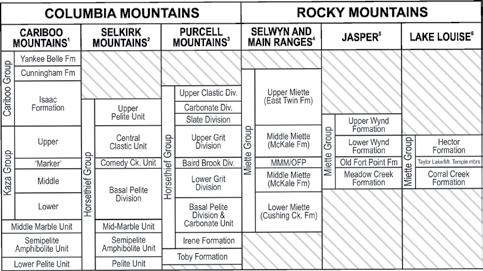
Stratigraphic nomenclature of the WSG in the southern Canadian Cordillera. Sources of information include: 1) Campbell et al. (1973), Ferguson (1994), Ross and Ferguson (2003a, 2003b); 2) Grasby and Brown (1993); 3) Kubli (1990), Kubli and Simony (1992, 1994), Warren (1996, 1997); 4) McDonough and Murphy (1989, 1994), Hein and McMechan (1994); 5) Charlesworth and Remington (1960), Charlesworth et al. (1967); 6) Walcott (1910), Gussow (1956, 1957), Aitken (1969).
(... Continued on page 16)
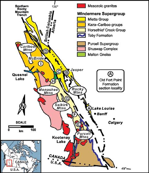
Figure 1 - Simplified geological map of the WSG, southern Canadian Cordillera showing prominent outcrop localities of the OFP and correlatives (modified from Ross and Murphy, 1988). Localities: A – Lake Louise; B – Jasper National Park; C – Mount Robson Provincial Park; D – McKale River; E – Frances Creek; F – Dogtooth Range; G – Selkirk Mountains; H – Monashee Mountains; I – Cariboo Mountains.
Figure 2.
RESERVOIR ISSUE 09 • OCTOBER 2015 15
Figure 3. A) Location map of key stratigraphic sections. B) OFP Type section, Old Fort Point Landmark, Jasper National Park. C) OFP principal reference section and GSM unit stratotype, Geikie Siding outcrop, Jasper National Park. D) TLM unit stratotype, near Temple Lake, Lake Louise. Note WMM is thinly (<0.5 m) developed here and difficult to distinguish from underlying GSM or overlying fine-grained Miette Group. E) WMM unit stratotype, “Upper Boomerang (#64) Ski Run, Lake Louise Ski Resort. Arrows in photos indicate stratigraphic up.
Alberta and British Columbia. Walcott (1913) extended his work further north into the Mount Robson area of British Columbia and defined the Precambrian Miette Formation (now Miette Group) from that area. Later, Allan et al. (1932) studied rocks in the Jasper area and described units lithologically similar to the OFP, but incorrectly placed them in the overlying Jasper series according to Charlesworth et al. (1961).
Further south, in the Purcell Mountains, Walker (1926) defined the Windermere Series, now Windermere Supergroup, and subdivided it into the Toby Formation, comprising coarse conglomerate and diamictite, and the Horsethief Formation, made up of sandstone and fine-grained slate (subsequently changed by Evans, 1933 to the Horsethief Creek Formation). Both authors mention purple slates lithologically consistent with the OFP (Walker, 1926, p. 14; Evans, 1933, p. 117), but no specific subdivisions or discussion of its stratigraphic significance were noted. Both Walker (1926) and Evans (1933) suggested correlation of
the Horsethief Creek Formation within the Purcell Mountains with the Hector and Corral Creek formations in the Lake Louise area. Later work by Reesor (1957) took another step by correlating strata of the Horsethief Creek series (later renamed the Horsethief Creek Group), Hector and Corral Creek formations with those of the Miette Formation in the Mount Robson area.
Henry Charlesworth and graduate students from the University of Alberta carried out the first detailed structural and stratigraphic mapping of the Precambrian Miette Group in the area around Jasper, Alberta (Fig. 1: B; Charlesworth et al., 1967).The name Old Fort Point Formation was first informally defined in a fieldtrip guidebook (Charlesworth and Remington, 1960) to describe a unit consisting of phyllite, limestone, limestone breccia and conglomerate that were easily distinguished from other Miette Formation strata as defined by Walcott (1913).
The name “Old Fort Point” comes from a prominent local landmark south of the Jasper townsite where accessible exposures
of the unit are located (Fig. 3B). Evans (1961) mapped the OFP at the Old Fort Point landmark and divided it into four informal members, each with a type section at this location. Based on lithological similarities, it was recognized that the Miette Formation (later changed to Miette Group) was correlative with the Corral Creek and Hector formations, and that the basal part of the Hector Formation (Walcott, 1910) was potentially correlative with the OFP (Evans, 1961; Charlesworth et al., 1961). Weiner (1966) followed-up on this work with a more regional structural study in the Jasper area, which included mapping and correlating the OFP using the previously defined units of Evans (1961). Compilation and formal definition of the OFP, including roposed regional correlations between Jasper, Lake Louise and southern British Columbia, were first published in Charlesworth et al. (1967). Aitken (1969) was the first to unequivocally correlate the OFP of the Jasper area (Charlesworth et al., 1967) with Walcott’s distinctive basal unit of the Hector Formation in the Lake Louise area.
He also repositioned the location of the Precambrian-Cambrian contact stratigraphically higher than that of Walcott (1910) and showed that it represented a major (angular) unconformity. Furthermore, work by Arnott (1984) and Arnott and Hein (1986) showed that the prominent “angular” unconformity at the base of the Cambrian as reported by Walcott (1913) was the base of a more than 100m deep WSG submarine canyon.
Subsequent regional mapping in the Cariboo Mountains (Campbell et al., 1973), Purcell Mountains (Reesor, 1973) and Rocky Mountains (Mountjoy, 1962, 1971; Mountjoy and Price, 1985; Price et al., 1980a, 1980b) focused on the general stratigraphic and structural geology in these areas rather than any one specific formation. No detailed documentation of the OFP was recorded, but similar to the early reconnaissance mapping, lithologies consistent with the OFP were noted in the Purcell Mountains (Reesor, 1973, p. 29, 31–32) and the Rocky Mountains (Mountjoy, 1962, p. 5). A geological map (1:50 000 scale) of the Lake Louise area (Price et al., 1980a) also shows a “position of change in facies (approximate)” between the Corral Creek and Hector formations of the Miette Group based on the work of Walcott (1910) and Aitken (1969), and represents the stratigraphic position of the OFP. A consistent, probably correlative, fine-grained triad of lithologies (siltstone, limestone-siltstone, organic-rich
(... Continued from page 15) 16 RESERVOIR ISSUE 09 • OCTOBER 2015
mudstone) that cropped out across the southern Canadian Cordillera was noted by a number of workers in the early 1980s:
1. P.S. Simony and graduate students from the University of Calgary (Calgary, Alberta): Monashee and Cariboo Mountains (Pell, 1984; Pell and Simony, 1981, 1982, 1984, 1987) (Fig. 1: H); Cushing Creek and McKale River areas, Rocky Mountains (Carey, 1984; Carey and Simony, 1985 (Fig. 1: D), Mount Robson Provincial Park area and Selwyn Range, Rocky Mountains (McDonough and Simony, 1988; McDonough, 1989) (Fig. 1: C), and Dogtooth Range, Purcell Mountains (Kubli, 1986, 1990; Kubli and Simony, 1992, 1994) (Fig. 1: F).
2. E.W. Mountjoy and graduate students from McGill University (Montréal, Québec): Park and Selwyn Ranges, Rocky Mountains (Klein and Mountjoy, 1988; Deschesne, 1990a; Deschesne and Mountjoy, 1990; Mountjoy and Grasby, 1990; Grasby, 1991) (Fig. 1: C), and Jasper National Park, Rocky Mountains (Deschesne, 1989, 1990b) (Fig. 1: B).
3. Others projects include D.C. Murphy from Carleton University (Ottawa, Ontario), Cariboo Mountains (Murphy and Rees, 1983; Murphy, 1986, 1987) (Fig. 1: H), S.E. Grasby, Selkirk Mountains (Grasby and Brown, 1993) (Fig. 1: G) and M.J. Warren from Queen’s University (Kingston, Ontario), Purcell Mountains (Warren, 1996, 1997) (Fig. 1: E).
These projects focused mainly on unraveling the structural complexity in their respective areas, which resulted in a number of location-specific, informal names for the OFP including: Old Fort Point Formation, Jasper National Park (e.g. Deschesne, 1989; 1990a) and Selwyn Range (McDonough, 1989; Deschesne, 1990b); Kaza Group “Marker”, Cariboo Mountains (Murphy, 1987; Ross and Thomson, 1990); Baird Brook Division, Dogtooth Range (Kubli, 1990; Kubli and Simony, 1992, 1994); Comedy Creek unit, Selkirk Mountains (Grasby and Brown, 1993); and upper and lower Markers, Purcell Mountains (Warren, 1996, 1997).
At the same time, G.M. Ross from the Geological Survey of Canada examined the Windermere succession from a sedimentological perspective in the Cariboo Mountains. Here he recognized not only the occurence of the lithological triad, but
more importantly its use as a stratigraphic marker to correlate with other regions in the southern Canadian Cordillera (Ross and Murphy, 1988). Although the name “Old Fort Point Formation” was utilized in subsequent maps and publications from the Selwyn Range (McDonough and Murphy, 1994), Cariboo Mountains (Ross et al., 1995; Ross, 2000; Ross and Ferguson, 2003a, 2003b) and Jasper National Park (Kendall et al., 2004), alternative names can still be found in the literature (e.g. Kubli and Simony, 1992, 1994; Grasby and Brown, 1993; Warren, 1996, 1997).
Formal Definition of the Old Fort Point Formation and its Three Members
Justification for Name: Old Fort Point Formation
The OFP is a unique lithostratigraphic unit in the WSG and has been recognized by many authors in many different areas of the southern Canadian Cordillera. It comprises three distinctive members that have a consistent stratal relationship, are correlatable and mappable on a regional scale, and can be easily distinguished from encompassing WSG strata. Despite these characteristics, no previous attempt has been made to formalize the nomenclature for this important basinwide unit beyond the boundaries of a local study (e.g. Gussow, 1957; Charlesworth et al., 1967; Kubli, 1990; Grasby and Brown, 1993). Given the significance of the unit, it is important to properly formalize the stratigraphic nomenclature of OFP across the southern Canadian Cordillera.
Although Walcott (1910) was the first to describe lithologies within the OFP, they were included in the basal portion of the Hector Formation and not specified as a separate unit. Gussow (1957) was the first to assign names to OFP lithologies (Taylor Lake and Mount Temple members), but these were not properly defined and were published in a conference fieldtrip guidebook. The name “Old Fort Point Formation” was the first informal (Charlesworth and Remington, 1960; Evans, 1961; Weiner, 1966) and then formal (Charlesworth et al., 1967) designation for this recognizable geological unit. Unfortunately, the type section specified by Charlesworth et al. (1967) is not representative of the full OFP succession (see below). Only strata of the upper member are present, and the more regionally extensive lower two members and their recognizable stratal
stacking pattern that permits basin-wide correlation are not exposed.
Despite these two issues, we propose that the name “Old Fort Point Formation” be retained and simply undergo a revision in definition to receive proper designation as outlined by the North American Commission on Stratigrahic Nomenclature (NACSN, 2005). The name “Old Fort Point Formation” is well established and has already been used by a number of authors in mapping and publications (e.g. McDonough and Murphy, 1994; Ross et al., 1995; Ross and Ferguson, 2003a; Ross and Arnott, 2007; Smith et al., 2005, 2007a, 2007b, 2011, this issue). Formal abandonment and renaming the formation would run contrary to the aim of this paper, which is to simplify the stratigraphy and avoid confusion for new researchers and readers. The name “Old Fort Point Formation” is preferred because it has historical priority and is the most widely used. Based on previous studies and more recent detailed work, especially Smith (2009), we also propose three new lithostratigraphic members for the OFP, which stratigraphically upward are: Temple Lake Member (TLM), Geikie Siding Member (GSM) and Whitehorn Mountain Member (WMM). These names are based on geographical locations where wellexposed representative sections can be easily observed and for the most part do not duplicate names already in the literature (Table 1; Figs. 2 and 3A).
Designation of Category and Rank of Units, Selection and Derivation of Name, Specification of Principal Reference Section and Stratotypes
Old Fort Point Formation
The name Old Fort Point Formation is proposed for the three-fold lithological unit that is unique to the stratigraphic succession in the Neoproterozoic WSG of the southern Canadian Cordillera. The OFP possesses distinctive lithological characteristics, is sufficiently thick to be mapped on a regional scale, and represents an identifiable stratigraphic horizon within Windermere strata (e.g. Price et al., 1980a, 1980b; McDonough and Murphy, 1994; Kubli, 1990; Ross and Ferguson, 2003a, 2003b, 2003c). The combination of these features warrants its formal definition as a formation in the WSG. The type section for the OFP is a prominent landmark (Fig. 3B) located <1 km southeast of Jasper,
18)
(... Continued on page
RESERVOIR ISSUE 09 • OCTOBER 2015 17
Alberta where strata of the OFP crop out (Charlesworth and Remington, 1960; Charlesworth et al., 1967).
The new principal reference section of the OFP, however, is proposed to be the Geikie Siding roadcut outcrop located along Highway 16, approximately 15 km west of Jasper, Alberta (UTM NAD27: 412974E 5858644N) (Table 1; Fig. 3C). The selection of this site as the principal reference section is based on a number of factors: it is well exposed, easily accessible and close to the previously defined type section (Charlesworth and Remington, 1960; Charlesworth et al., 1967); a Re-Os isochron age (607.8 ± 4.7 Ma) is from this locality (Kendall et al., 2004); and representative strata of all three members crop out.
Despite its suitability as a principal reference section, there are two important shortcomings. Firstly, the roadcut is in the core of the Meadow Creek Anticlinorium and neither the base nor top contacts of the OFP are exposed.The base of the OFP, herein taken to be the base of the TLM (see next), is exposed nearby in the same structure and was described previously by Charlesworth et al. (1961, 1967) and Weiner (1966). The top of the OFP, which is taken to occur at the top of the WMM (see below), is not exposed at Geike Siding, but is commonly observed elsewhere, for example Lake Louise, Mt. Robson, and the Cariboo Mountains.
The second issue is that the outcrop does not contain facies, especially in the
WMM, that are fully representive of those in other parts of the basin (see below). To illustrate this lithological variability, which is most pronounced in the WMM, a number of supplementary reference sections representing deposition in different parts of the Windermere basin are also designated (Table 1). Simplified descriptions and a composite OFP stratigraphic section are presented in Figure 4 with more detailed sedimentologic and stratigraphic description and interpretation in Smith et al. (this issue). Similar to the OFP, type sections of the three constituent members were selected based on the criteria of good exposure, representative lithological sections and ease of access. Also, their assigned names, for the most part, do not duplicate pre-existing names in the literature.
Temple Lake Member
The Temple Lake Member (TLM) is introduced to describe the variably coloured (purple, green, red-brown, grey) fine-grained, siltstone to mudstone, rare sandstone and rhythmic limestone-siltstone couplets of the lower OFP. The name of the member comes from an exceptional exposure near Temple Lake on the northeastern slope of Mount Temple, Lake Louise area where the unit stratotype is designated (Table 1; Fig. 3D). The type section for the TLM is specified as: UTM, NAD27: 557379E 5690015N; approximately 0.5 km east of Temple Lake, on the northeastern slope of Mount Temple, 6 km south from the village
of Lake Louise, Alberta. The outcrop is accessed from Moraine Lake Road where 5 km from its junction with the road to Lake Louise is the head of a little-used trail that leads to Temple Lake approximately 1.5 km to the west.
Geikie Siding Member
The Geikie Siding Member (GSM) is introduced to describe the light to dark grey, fine-grained mudstone (shale and pelite) unit with rare beds of dark-grey limestone and fine-grained sandstone of the middle OFP. The name of the member comes from the railway marker Geikie Siding, located along Highway 16, approximately 15 km west Jasper, located near the roadcut where the unit stratotype crops out (Table 1; Fig. 3C). The type section for the GSM is specified as: UTM, NAD27: 412974E 5858644N; located along Highway 16, between Clairvaux and Meadow creeks, approximately 15 km west from the townsite of Jasper, Alberta. The roadcut is on the south side of the highway, which also is the proposed new principal reference section for the OFP.
Whitehorn Mountain Member
The Whitehorn Mountain Member (WMM) is introduced to describe lithologically diverse strata in the upper part of the OFP. It is composed of diamictite, breccia to conglomerate, sandstone, quartzarenite, calcareous arenite, arenaceous limestone, limestone and mudstone to siltstone. The name of the member comes from Whitehorn Mountain in the Lake Louise Ski Resort. Approximately 0.5 km downslope from the peak on the “Upper Boomerang” Ski Run (#64), the type section is located and specified as: UTM, NAD27: 559666E 5702403N (Table 1; Fig. 3E). The narrow, cliff-face outcrop can be accessed in two ways from the base of the Lake Louise Ski Resort. The first is by taking the gondola part way up the front face (south slope) to the Whitehorn Day Lodge followed by a strenuous 4 km hike to the top of Whitehorn Mountain.
The second is an approximately 4 km hike along the Temple Fire Road to the Temple Day Lodge and then an additional approximately 3.5 km through the back bowl area. To demonstrate the lithological heterogeneity in the WMM, a composite stratotype consisting of a type section and a suite of supplementary reference sections is proposed. Supplementary references sections for the WMM include: McKale River area, approximately 20 km north of the town of McBride, British Columbia;
(... Continued from page 17)
18 RESERVOIR ISSUE 09 • OCTOBER 2015
Table 1. Section locations of the Old Fort Point Formation and its three constituent members.
Eagle Valley, approximately 24 km southwest of McBride, British Columbia; and Frances Creek area, approximately 30 km west of Brisco, British Columbia. Specific UTM locations are presented in Table 1.
Boundaries and Description of Lithologic Units
Temple Lake Member
The base of the TLM is marked by a dramatic change from generally grey-coloured mudstones and tan-coloured sandstones of the WSG to distinctively purple, green, red-brown strata of the TLM. In most places the change is sharp but can be gradational over an interval up to about 0.5 m thick. The TLM is fairly consistent in thickness (usually 50 to 125 m) and consists primarily of fine-grained siltstone to mudstone with isolated, carbonate-cemented sandstone beds that then grade upward into rhythmic limestone-siltstone couplets (see Smith et al., this issue, their fig. 4).
Sedimentary structures include: planar lamination, lenticular starved-ripple lamination, ripple cross-lamination, minor scours and normally graded beds. Bed thickness typically ranges from <1 cm to 10 cm, and depending on grain size, are interpreted as either T0 to T7 (Stow and Shanmugam, 1980) or Tcde, Tbd or Tbcd (Bouma, 1962) turbidites. Subordinate lithofacies in the TLM include uncommon limestone-clast breccia horizons interpreted as slump, slide or debris flow deposits (e.g. Lake Louise area) and at one locality (Frances Creek, Fig. 1: E), fine- to medium-grained thick-bedded massive sandstone interpreted to be Ta turbidites (Smith et al., this issue). Sedimentologic and stratigraphic features of this member are fairly consistent despite its widespread basin-slope to basin-floor deposition. The primary regional difference is a change in colour along a slope to basin-floor transect, including: purple to green, green to redbrown, and green to grey. Other minor differences include thinner, less frequent limestone beds in the strata of the Cariboo Mountains (Fig. 1: H) and thicker, more frequent sandstone beds at some localities (e.g. Purcell Mountains, Fig. 1: E).
Geikie Siding Member
The GSM is a light to dark grey coloured, organic-rich mudstone-pelite that usually is 2 to 15 m thick. The GSM gradationally, over an interval about 0.5–2 m thick, overlies the distinctively rhythmically interstratified limestone-siltstone couplets at the top of the TLM. The contact is also marked
by an upward fining, a dramatic decrease in the frequency of limestone interbeds and measureable changes in geochemical characteristics, including an increase in total organic carbon and molybdenum content (Ross et al., 1995; Smith, 2009; Smith et al., this issue).
Where discernible, strata of the GSM are interstratified with alternating siltstone and mudstone layers that are subtly normally graded implying traction and suspension deposition from dilute sediment-gravity flows (T6 to T8 or Tde). Rare isolated, thin-bedded, dark-grey, massive or parallel planar laminated limestone and very fine
ripple cross-stratified (Tc) sandstone are observed (see Smith et al., this issue, their fig. 5). Regionally, the GSM is lithologically uniform across the Windermere basin, and is usually considered the fine-grained mudstone-pelite cap in the lithologic triad of the OFP (Ross and Murphy, 1988; Kendall et al., 2004). Although the fine-grained and fissile character of this unit typically results in poor or covered exposures, notable exceptions are the type section roadcut near Jasper, Alberta and fresh periglacial exposures in the Cariboo Mountains, British Columbia.
(... Continued on page 20)
Figure 4. Generalized stratigraphic section of the OFP and its three constituent members with their principal lithofacies and stratal characteristics. Gamma-ray profile measured in counts per second (cps).
RESERVOIR ISSUE 09 • OCTOBER 2015 19
Whitehorn Mountain Member
The base of the WMM is sharp and locally deeply scoured (see Smith et al., this issue). In sections where the GSM and TLM are eroded completely, or where the WMM is thin (<0.5 m) and fine-grained and underlain and overlain directly by mudstones of the GSM and WSG, respectively, the bounding surfaces of the WMM are difficult to recognize in outcrop and require the use of other techniques (e.g. gamma ray or geochemistry) to identify their location (Smith, 2009, Smith et al., 2011, this issue).
Lithologically, the WMM is the most complex of the members of the OFP (Fig. 4; see also Smith et al., this issue, their fig. 6). Unlike the TLM and GSM, it consists of a diverse assemblage of lithofacies, which commonly are location-specific. Moreover, sections interpreted to have been deposited in the proximal part of the basin (see below) tend to be variable in their thickness (<0.5 to 165 m) even over relatively short distances, which is a consequence of (erosional) relief along the basal contact (Smith et al., this issue, their fig. 7B, 8). In contrast, more distal deposits of the WMM are more sheetlike with little change in thickness laterally (Smith et al., this issue, their figure 10). Nevertheless, notwithstanding paleogeographic location, lithofacies of the WMM are diverse and include, diamictite, breccia to conglomerate, mudstone to siltstone, sandstone, quartzarenite, calcareous arenite, arenaceous limestone and limestone. Diamictite and breccia to conglomerate most commonly occur in the lower part of the WMM and are interpreted to be debris flow deposits consisting of erosionally based, massive beds with a matrix of mudstone to siltstone or well-sorted, coarse-grained quartz sandstone (Fig. 4).
Bed thickness (<0.5 to >10 m) and clastsize (cm to m) are variable with clasts composed of material eroded locally from older OFP strata, or carbonates eroded from a shallow-marine platform and remobilized into deep-water (Smith et al., this issue). Mudstone–siltstone consists of medium-laminated turbidites (T0 to T8 or Tcde) with structures that include parallel-planar lamination, micro-scours, subtle normal grading, single chlorite flakes and rare scours. These strata, like fine-grained strata in the TLM, commonly exhibit a variety of colours (purple, green, grey), are up to approximately 100 m thick and comprise a monotonous fine-grained succession interrupted rarely by interbeds
of diamictite, breccia to conglomerate or sandstone (Figs. 3E, 4).
Sandstone shows a variety of textures (fine to very coarse-grained, poor- to well-sorted) and maturity (immature to supermature). In the upper part of the WMM well-sorted, mature quartzarenites interbedded with dark, organic-rich limestone beds crop out (Fig. 4). These two end-member lithologies commonly exhibit a range of compositions (e.g. calcareous arenites or arenaceous limestones). Soft-sediment deformation features are common in both fine- and coarse-grained facies, including load structures, convolute or contorted bedding and ductile folding.
Dimensions and Regional Correlations
The OFP is a recognizable, widespread unit that is locally exposed over an area of approximately 35 000 km2 in the southern Canadian Cordillera (Fig. 1). Thickness ranges from approximately 50 to 450 m, with most sections between 60 and 125 m. Moreover, thickness of both the TLM (50 to 125 m) and GSM (2 to 15 m) are fairly consistent across the Windermere basin, except for the anomalously thick section at Frances Creek (see discussion in Smith et al., this issue). In contrast, the WMM thickness is highly variable and ranges from <0.5 to 165 m and relates directly to depth of incision along its basal contact, which in turn is controlled by paleogeographic position (see below).
Although early correlations of the OFP were based primarily on its distinctive purple and green colours (Gussow, 1957; Charlesworth et al., 1967; Aitken, 1969), the recognition of the lithological triad of the siltstones, limestone-siltstone rhythmites (TLM) and mudstone-pelite (GSM) and their consistent stratigraphic position sandwiched between two thick coarse-grained WSG units, facilitated its widespread correlation throughout parts of Alberta and British Columbia (e.g. Pell and Simony, 1987; Ross and Murphy, 1988; McDonough, 1989; Kubli, 1990; Ross et al., 1995; Ross and Ferguson, 2003a). However as noted earlier, this lithological triad does not include strata that crop out at the type section of the OFP as defined originally by Charlesworth et al. (1967).
These strata, like similar lithologies at many other localities in the southern Canadian Cordillera, are considered here to be part of the WMM, specifically its lower part, and accordingly justifies the inclusion of the
WMM as a member of the OFP. In addition, the common limestones and mineralogical composition of sandstones in the WMM are more similar to local strata of the TLM and GSM as opposed to the locally enveloping “grits” of the WSG (Smith et al., this issue).
Geological Age
Unlike most strata from the ca. 750 to 569 Ma WSG, the minimum timing of deposition for the OFP is constrained by a precise ReOs isochron age of 607.8 ± 4.7 Ma (MSWD = 1.2) from organic-rich mudstone from the GSM type section along Highway 16, approximately 15 km from Jasper, Alberta (Kendall et al., 2004; Fig. 3C). From the same samples a similar but less less precise date of 634 ± 57 Ma (MSWD = 65) was also obtained (Kendall et al., 2004). This latter date was obtained from samples prepared using the conventional inverse aqua regia digestion preparation method compared with a CrO3-H2SO4 dissolution technique for the younger age.
Notwithstanding, both ages are consistent within the poorly constrained WSG where only maximum and minimum limits on deposition have been obtained. A local maximum depositional age of 736 +23/17 Ma (U-Pb zircon) was obtained from orthogneisses of the Malton Gneiss Complex (McDonough et al., 1991) and corresponds well with the range of approximately 740 Ma to 728 Ma from other basement rocks beneath the unconformity at the base of the WSG (Ross et al., 1995; Colpron et al., 2002). Rift-related mafic metavolcanic rocks in northeastern Washington, interpreted to be Toby Formation correlatives were imprecisely dated at 762 ± 44 Ma from a Sm-Nd isochron (Devlin et al., 1988).
More recent work on similar rift-related volcanic rocks in northern British Columbia, Idaho and Utah has produced more precise U-Pb zircon ages that range from ca. 709 to 667 Ma (Ferri et al., 1999; Lund et al., 2003; Fanning and Link, 2004; Balgord et al., 2013), but they are much younger than local WSG estimates and differ from each other by about 40 my. The minimum timing of deposition is constrained by a U-Pb zircon age of 569.6 ± 5.3 Ma from synrift felsic volcanic rocks of the Hamill Group that unconformably overlie the WSG (Colpron et al., 2002).
Depositional Model
In the southern Canadian Cordillera, sedimentary rocks of the WSG, including the OFP, were deposited in deep water along the continental margin of Laurentia, or ancestral
(... Continued from page 19) 20 RESERVOIR ISSUE 09 • OCTOBER 2015
North America (see Ross and Arnott, 2007 for general discussion). Fine-grained, mostly turbiditic strata of the lower (TLM) and middle (GSM) members are regionally uniform in thickness and lithofacies, have gradational contacts and imply synchronous deposition across much of the deep-marine part of the Windermere basin (see Smith et al., this issue, their fig. 9). The TLM followed by the GSM is interpreted to be related to a major eustatic rise that caused an overall shutdown of coarse, immature siliciclastic sediment supply to the basin (Ross and Murphy, 1988; Smith et al., this issue).
The eustatic rise and related transgression are attributed to continental deglaciation, in addition to an increase in nutrient supply that led to increased organic productivity and possible seawater stratification that facilitated the development of episodic bottom-water anoxia (Ross and Murphy, 1988; Smith et al., this issue). The upper member (WMM), on the other hand, is much more lithologically diverse and variable in thickness, even locally. This variability is interpreted to be controlled by paleogeographical location. Successions that show dramatic changes in thickness and lithological diversity are interpreted to have been deposited on the continental slope.
Here, the deeply incised basal contacts, and hence thick stratal successions of the WMM, represent the base and fill of locally deeplyincised (slope) submarine canyons (see Smith et al., this issue, their fig 9). Sediment that accumulated in the canyons represents a mixture of locally derived detritus (e.g. canyon-wall collapse) and that transported from the shelf sediment-staging area. Further basinward, which in the southern Canadian Cordillera is generally toward the west-northwest (Ross and Arnott, 2007) , the more sheetlike geometry of WMM strata represents deposition in basin-floor lobes (e.g. Terlaky, 2014). Additionally, the more uniform lithological composition of these strata is a consequence of the limited mobility of slope-derived debris flows and slumps, in addition to upflow sediment sorting within more mobile, basinwardflowing sediment-gravity flows (i.e. turbidity currents). Incision of the WMM submarine canyons, which further basinward fed the basin-floor lobe systems, is interpreted to have coincided with an abrupt fall of relative sea-level caused, at least in part, by uplift that temporarily interrupted the eustatic rise related to the melting of continental ice sheets (Smith et al., this issue). A more complete description of the lithological make up and geological evolution of the
OFP and its three constituent members can be found in Smith et al. (this issue).
Conclusions
Stratigraphic nomenclature for deepmarine sedimentary rocks of the WSG in the southern Canadian Cordillera is complex. The OFP is a lithologically unique unit that forms an important stratigraphic marker horizon in the WSG, and is mappable and correlatable on a regional scale in the southern Canadian Cordillera. The formalization of the stratigraphic nomenclature of the OFP and its three constituent members provides a simple and consistent stratigraphic framework for part of the WSG in the southern Canadian Cordillera. Proper formalization of the name Old Fort Point Formation provides a vital stratigraphic aid in unraveling the stratigraphic complexities of the Neoproterozoic in western North America
References
• Aitken, J.D. 1969. Documentation of the sub-Cambrian unconformity, Rocky Mountains main ranges, Alberta. Canadian Journal of Earth Sciences, v. 6, p. 193–200.
• Allan, J.A., Warren, P.S. and Rutherford, R.L. 1932. A preliminary study of the eastern ranges of the Rocky Mountains in Jasper Park, Alberta. Transactions of the Royal Society of Canada, v. 26, p. 225–249.
• Arnott, R.W.C. 1984. Proximal channel deposits of the Precambrian Hadrynian Hector Formation, Lake Louis, Alberta. Unpublished M.Sc. thesis, University of Alberta, 149 p.
• ________ and Hein, F. J. 1986. Submarine canyon fills of the Hector Formation, Lake Louise, Alberta: late Precambrian syn-rift deposits of the proto-Pacific Miogeocline. Bulletin of Canadian Petroleum Geology, v. 34, p. 395–407.
• Balgord, E.A., Yonkee, W.A., Link, P.K. and Fanning, C.M. 2013. Stratigraphic, geochronologic, and geochemicalrecord of the Cryogenian Perry Canyon Formation, northern Utah: Implications for Rodinia rifting and snowball Earth glaciation. Geological Society of America Bulletin, v. 125, p. 1442–1467.
• Barnes, N.E. and Normark, W.R. 1985a. Diagnostic parameters for comparing modern submarine fans and ancient turbidite systems. In: Submarine Fans
and Related Turbidite Systems. A.H. Bouma, W.R. Normark and N.E. Barnes (eds.). New York, Springer-Verlag, p. 13–14.
• ________ and ________ 1985b. Diagnostic parameters for comparing modern submarine fans and ancient turbidite systems. In: Submarine Fans and Related Turbidite Systems. A.H. Bouma, W.R. Normark and N.E. Barnes (eds.). New York, Springer-Verlag, wall map [modified].
• Bouma, A.H. 1962. Sedimentology of some flysch deposits; A graphic approach to facies interpretation. Amsterdam, Elsevier, 168 p.
• Campbell, R.B., Mountjoy, E.W. and Young, F.G. 1973. Geology of McBride map-area, British Columbia. GeologicalSurvey of Canada Paper 7235, 104 p.
• Carey, J.A. 1984. Geology of late Proterozoic Miette Group, southern Main Ranges, Cushing Creek area, B.C. Unpublished M.Sc. thesis, University of Calgary, Calgary, Alberta, 119 p.
• _______ and Simony, P.S. 1985. Stratigraphy, sedimentology and structure of late Proterozoic Miette Group, Cushing Creek area, B.C. Bulletin of Canadian Petroleum Geology, v. 33, p. 184–203.
• Charlesworth, H.A.K. and Remington, D.B. 1960. Precambrian rocks in the vicinity of Jasper, Alberta. Edmonton Geological Society, v. Second Annual Field Trip Guide Book, p. 11–18.
• ________, Evans, C.R. and Stauffer M.R. 1961. Precambrian geology in the Jasper-Geikie area. Edmonton Geological Society, v. Third Annual Field Trip Guide Book, p. 3–13.
• ________, Weiner, J.L., Akehurst, A.J., Bielenstein, H.U., Evans, C.R., Griffiths, R.E., Remington, D.B., Stauffer, M.R. and Steiner, J. 1967. Precambrian Geology of the Jasper Region, Alberta, v. 23, 74 p
• .
For a Full List of References please visit ww.CSPG.org/cspg/Reservoir
RESERVOIR ISSUE 09 • OCTOBER 2015 21

“This pioneer and explorer in geology, engineering and natural gas technology bequeathed a fundamental knowledge, years ahead of his time and was considered by many a virtual Leonardo da Vinci of the Petroleum Industry. Slipper, our First President, deserved the honour (unbeknownst to him) of our highest award in the Canadian Society of Petroleum Geologists” (Aubrey Kerr).
The Stanley Slipper Medal is the CSPG’s highest honour.
The gold medal is presented annually for outstanding contributions to oil and gas exploration in Canada. The contributions of the winner of this award should encompass a number of activities related to aspects of petroleum exploration. Such activities include: initiating and/or leading exploration programs, significant discoveries on new or existing exploration trends, teaching and/or training of explorationists, and involvement in and leadership within geological societies and professional organizations.
The committee is currently calling on the CSPG membership to provide additional nominations for this prestigious award. The award winner must be a CSPG member and should be able to attend the awards presentation to be held in the spring of 2016.
Please include an updated bibliography and letters in support of your nominee.
Nominations should be mailed, faxed or emailed before October 15 to:
CSPG Stanley Slipper Committee – Clint Tippett 110, 333 – 5 Ave SW Calgary, AB T2P 3B6
Email: clinttippett@shaw.ca Phone: 403-264-5610 Fax: 403-264-5898
 2014 Stanley Slipper Recipient
Wanye Foo
2014 Stanley Slipper Recipient
Wanye Foo
22 RESERVOIR ISSUE 09 • OCTOBER 2015
Stanley Slipper Medal
RESERVOIR ISSUE 09 • OCTOBER 2015 23
GO TAKE A HIKE
Second White Specks Formation, Highwood River, S.W. Alberta
| By Nick Zajacand Per Kent Pedersen
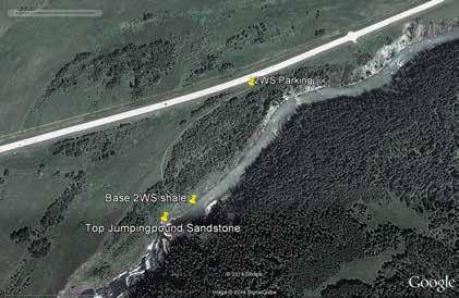
Trailhead: (50°33.174’N 114°21.244’W). Drive south from Calgary on Hwy22 towards Longview and then west along Hwy 541/40. Proceed 11.5 km from junction and park on south side of road.There is a second parking spot about 250 metres further west.The two possible trail routes are mark in blue and yellow.
Distance: Thetrails lead through overgrowth to the banks of the Highwood River. Take care descending to the outcrops.
Below: Panoramic view from SW to NE of the Second White Specks Formation (2WS), taken across the river from the outcrop. Strata dips toward the Southwest. The Cenomanian Belle Fourche is the oldest formation exposed and is overlain by the Turonian aged Vimymember, the basal part of the Second White Specks Formation (2WS) and the Jumping Pound sandstone (the upper 2WS).The final unit exposed is the upper Turonian aged CarlileFormation.
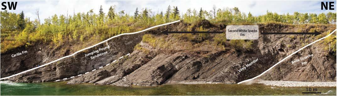
within the subsurface of the Western Canada Sedimentary Basin (WCSB). The foothills region is comprised of a series of imbricated/stacked thrust sheets (Newson et al., 2001) that contain supreme examples of the Upper Cretaceous Second White Specks Formation (such as this location) and encompass strata from the Bow Island Formation to the Cardium Formation with only minor internal deformation. The Second White Specks Formation (2WS) is notable for its deposition at a time when the Western Interior Seaway reached its maximum extent but it then infilled with sediment so that by the time the CarlileFormation was deposited the seaway was only a few hundred kilometres wide (Nielson et al, 2008). The 2WS is an important source rock for the WCSB, having sourced the majority of the oil in the overlying prolific Cardium sandstones (Creaneyet al. 1994), and it is considered a prospective unconventional shale oil resource play across western Alberta. The outcrop at this location provides a rare window into the depositional processes, sedimentologicalvariability and potential reservoir characteristics of a mudstone dominated succession that may not be evident in core and inwell logs.
From the parking area in the ditch along Hwy 40, a fishing gate provides access through the barbed wire fence. A faint trail through the pasture fields approximately extends ~250m towards the west, eventually leading onto a trail through the trees towards the Highwood River Canyon. At the edge of the river canyon, a steep trail provides access onto the bedding plane, demarcating the top of the Jumping Pound Sandstone of the uppermost 2WS, backing onto the Highwood River. Following the
fine grained sandstone deposits of the Belle Fourche Formation. Bivalve casts are found with abundance in this unit in addition tosmall and large ammonite casts that are more rarely found. This shale interval is highly fissile and organic rich, forming a resistive bench with respect to the surrounding strata.The general lack of traction current bedformsindicates deposition below storm wave base in a low-relief shelf setting, during the peak of the Greenhorn transgression (Schroder-Adams et al., 1996).
The organic rich mudstone becomes gradually interbedded with thin, very fine grained sandstone beds, with the succession formingseveral sandingupwards parasequences. The sandstone beds contain discontinuous lenticular current ripples (>1 cm thick) and graded beds with the tops often wave rippled, reflecting deposition above storm wave base. Bentonite beds are persistent throughout, and often act as detachment planes for internal structural deformation.The upper sandy portion forms the Jumping Pound sandstone, a unit only present within the westernmost part of the WCSB. Sandstone dominated strata of the Jumping Pound sandstone are characterized by relative continuous sandstone beds with well exposed combined-flow structures and uni-directional current ripples.
The outcrop offers a great example of vertical variability within a mudstone dominated succession expressed by changes in composition and bedformsthat relate to depositional processes and environments. From a reservoir standpoint, such observed lithological heterogeneityacts as a strong control on storage, flow parameters and fracture characteristics that are key to unlocking a potential resource play within the 2WS.
P P 100m P P 100m 24 RESERVOIR ISSUE 09 • OCTOBER 2015
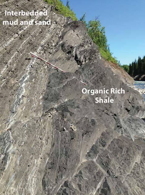
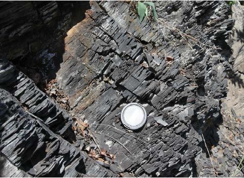
Above: Example of the gradational transition between the organic rich mudstone of the VimyMember to the interbedded mudstone, siltyand very fine grained sandstone beds of the middle part of the 2WS.The organic rich mudstone forms a resistive bench, due to the increased amount of calcareous cement within this mudstone facies.
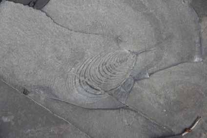

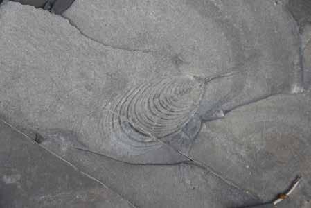

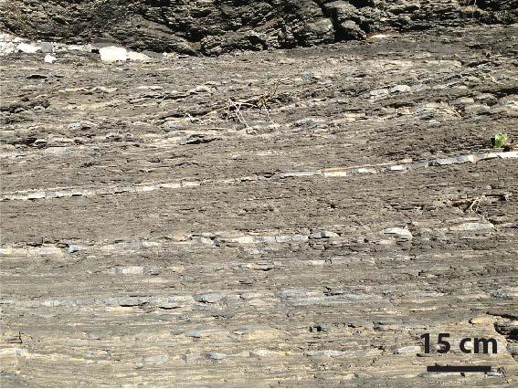
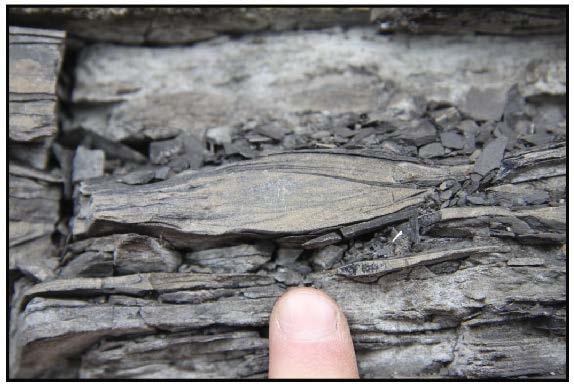
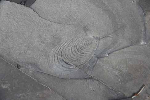
(Bottom Right)
RESERVOIR ISSUE 09 • OCTOBER 2015 25
Above: Partially deformed light grey bentonite ash bed. Volcanic ash layers occur frequently throughout the 2WS section.

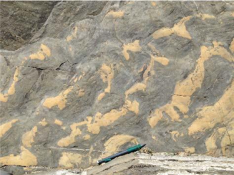
Above: Bedding plane view of uniand bi-directional ripples within the upper part of the Jumping Pound sandstone,deposited in a shallow water, marine shelf setting.
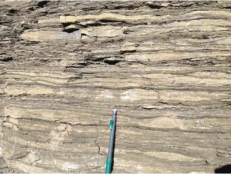
Above: Interbedded sand and mud displaying sandstone beds with combined flow structures, convoluted beds and lenticular uni-directional current ripples within the Jumping Pound sandstone.
Left: The top of the Jumping Pound sandstone is found at the base of the trail heading down from the top of the river valley.This unit forms an extensive ridge adjacent to the Highwood River and displays well developed conjugate fracture sets, highlighting the regional stress regime.
Creaney, S., Allan, J., Cole, K.S., Fowler, M.G., Brooks, P.W., Osadetz, K.G., Macqueen, R.W., Snowdon, L.R., and Riediger, C.L. 1994. Petroleum generation and migration in the Western Canadian Sedimentary Basin (p. 455-468), in G.D. Mossopand I. Shetsen, comps., Geological Atlas of the Western Canada Sedimentary Basin, Canadian Society of Petroleum Geologists and Alberta Research Council, Calgary, 510p.
Newson, A. C. 2001. The future of natural gas exploration in the foothills of the western Canadian Rocky Mountains. The Leading Edge, v. 20 no. 1, p. 74-79. Nielson, K S; Schröder-Adams, C J; Leckie, D A; Haggart, J W; Elberdak, K. 2008. Turonian to Santonian paleoenvironmentalchanges in the Cretaceous Western Interior Sea: The Carlileand Niobrara formations in southern Alberta and southwestern Saskatchewan, Canada. Palaeogeography, Palaeoclimatology, Palaeoecologyvol. 270, 2008; p. 64-91.
Schroder-Adams, C.J., Leckie, D.A., Bloch, J., Craig, J., McIntyre, D.J., and Adams, P.J. 1996. Paleoenvironmentalchanges in the Cretaceous (Albianto Turonian) Colorado Group of western Canada: microfossil, sedimentologicaland geochemical evidence. Cretaceous Research, v. 17, p. 861-882.
Kjp (2ws)
Kcrl
Kjp (2ws)
Kcrl Kjp (2ws)
26 RESERVOIR ISSUE 09 • OCTOBER 2015
Kcrl
CONTINUING EDUCATION Upcoming CSPG Short Course
SAGD‐Reservoir Engineering for Geo‐scien�sts & Non Reservoir Engineers
Course Descrip�on
Hussain Sheikha
This course is designed to provide basic understanding of thermal recovery of bitumen. The unique physical proper�es of bitumen. Basic understanding of thermal recovery methods like Cyclic Steam S�mula�on (CSS), Steam Flood, and Toe‐to‐Heel Air Injec�on (THAI). It covers the prac�cal aspects of commercial development of SAGD pads, pads layout, drilling, comple�on, and produc�on. All phases of SAGD produc�on like start up and wind‐down are covered in this course. SAGD’s wellpair produc�on rate using Butler’s equa�on and steam requirement to produce bitumen. Reservoir simula�on of SAGD process and the key components of geological and simula�on models. How simula�on model results guide pad development.
Special a�en�on is paid to SAGD enhancement processes, new technologies, steam proper�es, steam trap, different well comple�on congura�on and smart wells, sand control, SAGD side‐track, reservoir surveillance and management, and surface components of pads and central process facility.
SAGD geo‐mechanics, role, effects, deni�on of cap rock and how it is tested are also examined in this course. What are the key performance indictors of SAGD. The success and challenge of SAGD will be demonstrated by two SAGD eld cases.
Who Should A�end
This course is designed to provide basic understanding of subsurface bitumen recovery methods and also the fundamental concepts of thermal recovery. This course is indented for professional with no formal petroleum training. This course is ideal for G&G personal, Engineers in Training, Facility Engineers, coop students, non‐reservoir engineering disciplines, non‐technical personnel and those who new to oil and gas industry, or business units who may want a basic understanding of the SAGD process.
Note: A�endees will receive a comprehensive manual
Instructor Informa�on
Dr. Hussain Sheikha is currently a Senior Reservoir Engineer with Denbury Resources, reservoir management of EOR CO2 oods. Prior to joining Denbury he worked with Suncor Energy from 2010‐2015, Firebag and MacKay River Asset Teams as a development and op�miza�on Engineer. His work has been very diversied covering conven�onal and heavy oil reservoirs proper�es, primary, secondary and ter�ary opera�ons, and reservoir development of brown and green projects. He worked for Penn West Explora�on with EOR team from 2007 to 2010 in development of hydrocarbon miscible ood, waterood, polymer and CO2 injec�on. He was a faculty member of Petroleum Engineering Department at the Bright Star University of Technology from 1994 to 2000 where he taught different petroleum engineering courses. He also taught several industry training courses in thermal and enhanced oil recovery. He graduated with a Ph.D. in petroleum engineering from the University of Calgary. He is a Registered Professional Engineer in the Province of Alberta, a member of Canadian Heavy Oil Associa�on, SPE, and associate member of Canadian Society of Petroleum Geologists.
RESERVOIR ISSUE 09 • OCTOBER 2015 27
START DATE
LENGTH
days INSTRUCTORS
PDH
Register online today at www.cspg.org
28 ‐ Oct ‐ 15
2
Dr.
Credits 16 Hours
Register online at www.cspg.org
CONTINUING EDUCATION
Upcoming CSPG Short Course

Course Descrip�on
Resources and reserves are largely misunderstood by all but a small por�on of the engineering community and yet they are a vital scorecard for oil and gas companies. Understanding the principles, the �ming of reports, as well as ensuring the best informa�on is provided are cri�cal to appropriate evalua�ons. All disciplines need to be involved in this process. This short course is designed to provide geoscien�sts with the informa�on they need to provide effec�ve input to these evalua�ons.
This 1 day course will cover the regulatory requirements of evalua�ons, resource and reserve categoriza�on, risk, produc�on forecas�ng and the impact of pricing. Prac�cal examples from conven�onal and unconven�onal reservoirs in the Western Canada Sedimentary Basin will be used as learning tools.
Instructor Informa�on
Dave Russum has spent his career nding and developing oil and gas for E&P companies (Amoco and Crestar Energy) and providing independent evalua�ons and advice (Geo‐Help Inc., AJM Petroleum Consultants and Deloi�e). His background provides a very broad view of the industry and the expansion of unconven�onal ac�vity. He is a former Technical Director of the CSPG and a member of the CSPG, AAPG and APEGA. He is currently Director of Geoscience for Deloi�e Resource Evalua�on and Advisory where he and his team provide geoscience services in North America and on a global basis.
Andrew Bo�erill is a graduate of the University of Calgary with nearly 15 years of experience in reservoir engineering with AJM Petroleum Consultants and Deloi�e. He is a former partner in AJM Petroleum Consultants and is currently a Senior Manager in Deloi�e’s Resource Evalua�on and Advisory prac�ce. He has evaluated oil and gas assets for more than 160 interna�onal and domes�c clients. He is an expert in probabilis�c resource evalua�on and provides advisory services for many clients par�cularly in the area of mergers and acquisi�ons. Andrew also leads the team that prepares Deloi�e’s quarterly oil and gas price forecasts.
Prac�cal Risk, Resource and Reserves for Geoscien�sts START DATE 18 ‐ Nov ‐ 15 LENGTH 1 day INSTRUCTORS Dave Russum & Andrew Bo�erill PDH Credits 8 Hours Register online today at www.cspg.org
28 RESERVOIR ISSUE 09 • OCTOBER 2015


elizabeth macey, B.A., cartographer . 993. 0055 emacey@telus.net www3.telus.net/elizabethmacey . . presentations posters graphics . maps technical illustrations RESERVOIR ISSUE 02 • FEBRUARY 2015 9 • Domestic and International wellsite supervision • Conventional and Unconventional wells • Extensive Hz experience • Customized corporate solutions available (403) 250-3982 sales@clconsultants.ca www.clconsultants.ca Wellsite Geologists Inc. the Rock Solid Choice Wellsite Supervision Project Management Graphic Well Profiles Verticals / Horizontals EUB Sample / Core Studies Conventional / Un-conventional 1350, 734 - 7th Ave SW Calgary, AB T2P 3P8 B 403.234.7625, www.WellsiteGeologists.com C 403.660.9883, info@WellsiteGeologists.com 1602 – 5th St N.E. Calgary, AB. T2E 7W3 Phone: 403-233-7729 www.tihconsulting.com e-mail: tih@shaw.ca T.I.H. Consulting Ltd. Geologic Well-Site Supervision
CORPORATE SUPPORTERS
RIGSAT Communications
Pason System
Big Guns Energy Services
Earth Signal Processing Ltd.
Golder Associates
Birchcliff Energy Ltd.
Canada Brokerlink Inc.
Little Rock Printing
Nalcor Energy
Paramount Resources
Pulse Seismic Inc
Compass Directional Services
EV Cam Canada Inc.
Lee Energy Systems
Roke Technologies Ltd.
Explor
Japan Canada Oil Sands Ltd.
RPS Energy Canada Ltd.
Sproule Associates Limited
Waterline Resources
Serpa Petroleum Consulting Ltd.
Cabra Consulting Ltd.
McDaniel & Associates Consultants Ltd.
National Oilwell Varco
Signature Seismic Processing Inc.
Geovariances
Hurry Hydrocarbons
Navigator Resource Consulting
NExT- A Schlumberger Company
Valeura Energy
Statoil Canada
Mundiregina Resources Canada
Mcleay Geological Consultants Ltd.
Enviro-Tech Surveys Ltd
Tucker Energy Services Canada
Gaffney, Cline & Associates
Bounty Developments Ltd.
Franconia Geoscience
GeoChemTech Inc.
Prospect Drivers Inc.
Company Patron
Journey Energy Inc.
Rife Resources Ltd.
HONORARY MEMBER
Kathryn (Kathy) Scales
Kathryn Scales earned an Honours B.Sc. in Geological Sciences in 1978 from Queen’s University, and joined the CSPG the same year. Kathy joined her first committee in 1980, the Technical Luncheon Committee, and served on it for six years. She was the Youth Science Foundation Liaison from 1983 through 1990, and the Public Affairs Committee Chairman from 1986 to 1991. Kathy served as the Liaison to the Petroleum Communication Foundation for a decade starting in 1986, and during that time also served on the Core Conference Committee in 1988 and the Golf Tournament Committee in 1991. Ms. Scales’ three year Executive term was centered on her 1999 Presidential year. There she led the creation of a five year plan, which involved assessing the CSPG, its strengths and weaknesses, and created a path to reach to the objectives the Board set, including continuing to push the CSPG to be a truly national organization.
In addition to volunteering with the CSPG, she has also been active in other organizations. Starting in 1993, Kathy spent seven years as a Member of AAPG’s House of Delegates, including two years as Chairman (1995 –1996). She has spoken many times at her alma mater, including as part of the Oil & Gas Speaker Series (2009 – 2010), Pollution Probe Energy Literacy series “Energy Systems in Canada” workshop (2011), as well as serving on Queen’s Geology Council (2004 – 2013). She has also facilitated the University of Alberta Business Competition (2009). While at Petro-Canada, she was the President of the both the Squash Club (1981 – 1983) and the Pacers Track Club (1988). During the 1988
Olympics, she was an information host at Athlete’s Village and an escort runner for the Torch Relay. Ms. Scales also has volunteered her time with the Calgary Science Fair as a judge (1986 – 1987), Junior Achievement (1998), community soccer (2002 – 2004) and the Bearspaw Golf Club (2013 – 2014).
Kathy started her career at Petro-Canada in 1978 and stayed there, advancing through the ranks. She started as a Geologist, and in 1992 was promoted to Project Coordinator of Asset Rationalization, where she was responsible for the evaluation of oil and gas properties in Western Canada. Two years later, Ms. Scales started a six year term as a Senior Geologist, generating new prospects in Alberta as well as overseeing the evaluation of the Hibernia field. In 2000 Kathy moved in to a new phase of her career, focusing on the environment. She worked as an Environmental Advisor for three years, providing technical support for climate change and air emissions issues, working with internal clients and regulatory authorities. Next, she became the Team Lead of Environment, Regulatory Affairs and Stakeholder Relations, working on issues with oil sands projects. Ms. Scales became Petro-Canada’s Climate Change Strategies Advisor in 2005, ensuring that the company had appropriate strategies in place to respond to pending Canadian and international regulations on greenhouse gas emissions, managed the internal Climate Change Committee, worked closely with industry associations and regulatory authorities to influence the development of technical strategies, key industrial climate change and greenhouse gas regulations and policies, as well as air emissions issues. Following the Suncor and Petro-Canada merger in 2009, Kathy became the Energy & Climate Change Policy Advisor, ensuring that that Suncor was well-situated to deal with international greenhouse gas emission obligations and working to improve energy literacy across Canada. Kathy retired in 2012.
Ms. Scales has had a distinguished 34 years career as a geologist and environmental specialist. She has made a lasting mark on our industry, through years of working with stakeholders and governments, bringing much needed perspective to one of the most challenging public policy issues of our time –climate change. She is an engaging personality, a careful listener, a leader and a leader in her field. The CSPG is pleased to welcome Kathryn Scales as an Honorary Member.
AS OF JULY 31, 2015
30 RESERVOIR ISSUE 09 • OCTOBER 2015
WEDNESDAY NOVEMBER 18th
SPEAKERS: MATT GOLOMBEK
Mars Exploration Rover Project Scientist
Jet Propulsion Laboratory
California Institute of Technology
DON HLADIUK
Past-President
Royal Astronomical Society of Canada
DOORS OPEN: 4:30 PM
APPETIZERS/CASH BAR: 5:00 PM
EVENT: 6:00 PM
ARTS COMMON
205 - 8th Avenue SE Calgary AB
Adults: $25.00
Students: $10.00
Children (12 & under) FREE
www.cspg.org

SPONSORS: MacdonaldCole Inc.
2 0
RESERVOIR ISSUE 09 • OCTOBER 2015 31
1 5
CAN YOUR SOFTWARE WITHSTAND A FLOOD OF INFORMATION?

As the most dynamic data aggregator in the industry, Petrosys keeps your workflow moving.
Only Petrosys’ powerful suite of software effortlessly navigates the overflow of data from multiple sources and disciplines. Our industry-leading dynamic data aggregation, integration and surface modeling capabilities enable you to identify, refine and resolve issues more quickly. Dedicated technical support and service offer expert solutions when needed. And with our clear, logical interface, even getting started is smooth sailing. Start achieving exploration and production targets at a lower cost and in a shorter time frame with Petrosys. To learn more go to www.petrosys.com.au/transcend
D1028
MORE THAN MAPPING SOFTWARE SERVICES CONNECTIVITY DATA MANAGEMENT VISIT US AT SEG 2015 OCTOBER 18-21 BOOTH #1016 PETROSYS CSPG RESERVOIR2 2015.indd 1 24/08/2015 8:38 am
