
CANTERBURY-BANKSTOWN DEVELOPMENT CONTROL PLAN 2023 –CHAPTER 7.3 (CITY EAST)
SECTION 4 – CANTERBURY LOCAL CENTRE CHARLES STREET PRECINCT, CANTERBURY
Explanation
Connective City 2036 recognises Canterbury the Charles Street Precinct as forming part of the Canterbury Local Centre within the centres hierarchy. It provides urban and community services to a large suburban population and connects to good public transport. Section 4 applies to land shown in Figure 4a.

Desired character
The Canterbury Local Centre is the area of highest density along Canterbury Road, and comprises buildings ranging from three to nine storeys. Buildings over six storeys are restricted to specific sites, where they will have minimal impact on streetscape character and other residential areas.
The transformation of the local centre includes two zones; the traditional Town Centre, which lies to the northern side of the railway station, and the riverfront precinct. The latter, a collection of currently obsolete industrial/commercial sites, is located between the Cooks River and the Railway.
The transformation of the Charles Street Precinct includes the riverfront precinct, which formerly was a collection of obsolete industrial/commercial sites located between the Cooks River and the Railway.
The lower scaled buildings are likely to be infill sites additions to existing or heritage buildings or buildings in sensitive locations (such as close to the Cooks River or residential land).
Active retail exists along the major thoroughfares and pedestrian paths, with commercial and residential above creating a genuinely mixed-use environment. Residential is expected to be located on the upper floors.
Buildings accommodating retail are built to the footpath, whilst the residential buildings have setbacks appropriate to the context (road traffic and air quality). Showrooms are not permitted. Open space takes the form of regularly shaped streets, paths, promenades and plazas/piazzas.
Objectives
O1 To achieve the full development potential of land and best use of services in the centre.
O2 To encourage the redevelopment of the riverfront district into an attractive vital and vibrant mixed-use environment via a network of publicly accessible spaces and places.
O3 To create an attractive waterfront along the Cooks River through the provision of pedestrian and cycle ways, landscaped open spaces and opportunities for outdoor activities.
O4 To reinstate the role of the centre on Canterbury Road.
O5 To improve the structure and function of the centre.
O6 To establish the desired spatial proportions of the street and define the street edge.
O7 To minimise building size and bulk by setting back upper storeys.
O8 To minimise amenity impacts on adjoining sites.
O9 To allow for flexible design and building articulation by permitting minor encroachments.
O10 To ensure efficient vehicular access to parking and servicing and reduce driveway crossings.
O11 To facilitate efficient building envelopes that achieve optimum density.
Development controls
Lot size
4.1 Redevelopment in the Canterbury Local Centre Charles Street Precinct requires a minimum lot size of 1,500m².
4.2 Where redevelopment is proposed in the E1 zone, a minimum frontage of at least 18m shall be provided.
Public domain
4.3 Development is to be consistent with the public domain requirements identified in Figures 4a to 4d.


4.4 Key elements of the public domain that are to be provided for includes: the foreshore promenade along the Cooks River; and the creation of the Market Lane that provides a retail link from the railway station through to the foreshore promenade.


General
4.5 Where a setback applies, buildings are to provide articulated and varied facades that do not result in a ziggurat appearance (i.e. do not have the form of a terraced structure with successive receding storeys).
Front setbacks
4.6 Development must comply with the minimum front setbacks as follows: Location Number of storeys at the street and setback Upper level (podium) setback
E1 Zone along Canterbury Road and any secondary frontage
1–4 storeys minimum setback of 3m from street boundary
Basements to be 3m from street boundary
Above four storeys an additional 5m
Side setbacks setbacks are not required in the E1 zone when the desired character is for a continuous street frontage.
On boundary with residential zone – side setback
4.8 Establish a 45 degree height plane projected at 1.5m from the residential boundary.
4.9 Provide minimum 1.5m setback to the residential zone boundary.
4.10 A two storey limit on the boundary with residential zone applies (refer to Figure 4e).
On boundary with residential zone – rear setback
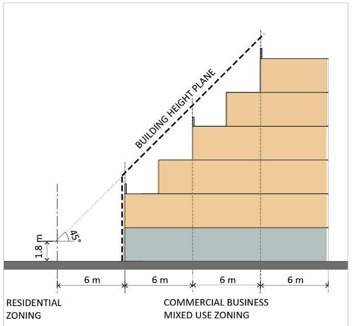
4.11 Establish a 45 degree height plane projected at 6m from the residential zone boundary.
4.12 Provide minimum 6m setback to the residential zone boundary.
4.13 A two storey limit on the boundary with residential zone applies (refer to Figure 4f).
4.14 A setback to a rear lane is not required.

Exceptions
4.15 The following minor building elements may project into the minimum side setback area:
(a) roof eaves, awnings, pergolas and patios; (b) stair or ramp access to the ground floor; and (c) rainwater tanks.