March 2024 EXPLORATION TRENDS & DEVELOPMENTS Complimentary PM #40069240 GEOPHYSICAL TECHNOLOGY ADVANCES
IN
is an annual publication prepared by Sean Walker
16 Forth Street, Edinburgh Scotland, U.K. EH1 3LH
Phone: +44 131 550 3707
Email: walker@cwgeophysics.ca
Published in co-operation with The Northern Miner
69 Yonge St., Suite 200 Toronto, ON M5E 1K3
Phone: (416) 510-6789
E-mail: tnm@northernminer.com
Editor:
Marilyn Scales
Writers:
Sean Walker and Tanya Boughtflower
Creative/Layout:
Mark Ryan
Production Manager:
Jessica Jubb
Advertising Sales:
Robert Hertzman
Michael Winter
Publisher:
Anthony Vaccaro
Printed in Canada.
All
MINERAL EXPLORATION TRENDS AND DEVELOPMENTS IN 2023
By Sean Walker geophysical consultant at Campbell & Walker Geophysics in Edinburgh, Scotland

This is the eighth year that Decennial Mineral Exploration Conferences (DMEC) has served as the patron for Exploration Trends & Developments. DMEC was formed in 2005 to formalize the organization of the decennial exploration conferences which began in 1967 and will continue in 2027. In addition to the exploration conferences, DMEC encourages workshops and conference forums that promote the better integration of technology in exploration. This year DMEC support came from the sponsoring companies listed on pages 18 and 19
In 2024 we celebrate the 60th anniversary of the ETD. As the originator of the ETD, Geological Survey of Canada (GSC) scientist Peter J. Hood wrote this unbiased annual publication on trends and new developments in geophysical exploration from 1965 until 1992 (28 years). When he retired Patrick Killeen, also a GSC scientist, began writing the ETD and carried on from 1993 until 2022 (30 years). While this is just my second year working on the ETD, I feel a great responsibility to maintain the high standard set by both Peter and Pat.
MARCH 2024 | EXPLORATION TRENDS & DEVELOPMENTS 3 EXPLORATION TRENDS & DEVELOPMENTS
of
may only be reproduced with the written consent of
EXPLORATION TRENDS & DEVELOPMENTS EXPLORATION TRENDS & DEVELOPMENTS 4 EXPLORATION TECHNOLOGY IN 2023 WHAT IS NEW? 6 CORPORATE HIGHLIGHTS 14 AIRBORNE GEOPHYSICAL SURVEYING AIRBORNE Magnetics Airborne Electromagnetics Airborne Gravity Airborne Radiometrics Other Airborne Methods 20 GROUND GEOPHYSICAL SURVEYING Borehole Geophysics Ground Electromagnetics Resistivity and Induced Polarization Magnetotellurics Physical Property Measurement Other Ground Methods 23 DATA PROCESSING DEVELOPMENTS 26 COMPANIES AND WEBSITES 26 ABBREVIATIONS 18,19 SPONSORS EXPLORATION TRENDS & DEVELOPMENTS EXPLORATION TRENDS & DEVELOPMENTS EXPLORATION TRENDS & DEVELOPMENTS GEOPHYSICAL TECHNOLOGY ADVANCES IN Cover photo:
rights reserved. The contents
this publication
Sean Walker.
Fire. CREDIT: QUANTEC GEOSCIENCE: CONTENTS EXPLORATION TRENDS & DEVELOPMENTS
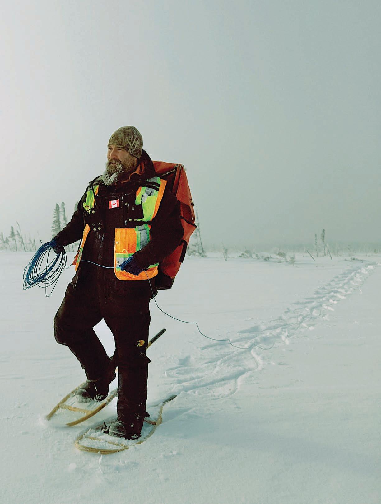
Jesse Rondeau laying wire for Titan MT survey in the Ring of
EXPLORATION TECHNOLOGY IN 2023: WHAT IS NEW?
As its name suggests, the goal of the ETD review is to highlight trends and developments. Each year we send out requests to equipment manufacturers, survey providers, software developers and consulting groups asking them to tell us about what they have been up to. The main task of writing the ETD each year is sifting through all the information and determining what is, in fact, new. As a result, I have spent quite a bit of time pondering the meaning of new. Some would say it is by design that the two words trends and developments provide the answer to my query.
Trends highlight what has happened in the past year. This can include everything from a change in services being offered to the opening of a new office, or an increase in equipment available for acquisition to a description of notable surveys completed. While not exactly new it is news.
Developments focus on new and improved technology. This includes the work being done by companies to address specific exploration challenges and make the entire process easier, safer, and more effective. In this edition of the ETD, we have made a concerted effort to put all the news into the corporate highlights section and all the developments
into the airborne geophysics, ground geophysics, and data processing sections.
During the compilation of the 2024 edition of the ETD, several themes emerged. The first was drones or UAVs. While they are not new – I recall discussions of drone magnetics 20+ years ago – they have become ubiquitous. The most widespread application remains magnetic surveying. However, service providers are rapidly expanding on this to include EM, radiometrics and LiDAR. There are also numerous resources for service providers and end-users available on the website www. GuidelinesForDroneGeophysics.com.
In 2023 we also saw an increase in the number of companies mentioning seismic, both passive and active, and LiDAR. The recent boom in pegmatite exploration, particularly in glaciated terrain, has been helped by detailed mapping of dykes using LiDAR alongside conventional airborne and ground geophysics. These are both examples of a well-established technology being adopted to solve a specific problem.
Other developments highlighted the collection of multiple data types simultaneously from a modified sensor. One airborne provider was able to provide TEM, VLF, and AFMAG data from a single system. Not to be outdone, ground providers
collected CSEM, MT, CSEM, and IP data simultaneously. The specific advantages of these data sets, beyond the decrease in acquisition cost and time, depend on the processing applied. One ground geophysical company reported that by modelling all the physics governing the combined CSEM and IP data they were able to overcome issues related to EM coupling.
In addition to gathering updates in 2023, we asked companies two questions: Compare business levels in 2023 to 2022 and how will your business levels in 2023 compare to 2024? The answers reflected the trends of increased and sustained levels of activity. Sixty-six per cent of companies that responded said that 2023 business levels were greater than 2022, and 60% said that they felt 2024 levels would be greater than 2023. While 23% said that business levels in 2023 were less than 2022 only 7% felt that 2024 levels would be less than 2023.
Over time patterns emerge that show how the ups and downs of the exploration cycle affect activity levels. It is also possible to track the relative importance of different commodities and how that in turn affects the demand for different technologies. In future editions of the ETD, we plan to look back over the 60 editions to highlight trends that have emerged throughout the years.
4 EXPLORATION TRENDS & DEVELOPMENTS | MARCH 2024 EXPLORATION TRENDS & DEVELOPMENTS n EXPLORATION TECHNOLOGY
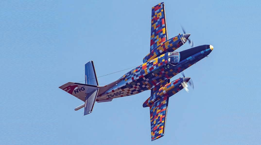
n This captivating shot was taken above Hartbeespoort Dam during a test flight of our newly branded Cessna F406, ZS-SSC aircraft. It immediately drew the attention of aviation enthusiast Paul Ludick, resulting in this incredible action photograph. CREDIT: NEW RESOLUTION GEO, PAUL LUDICK – (AIR TRANSPORT)
CORPORATE HIGHLIGHTS
Abitibi Geophysics of Quebec provides a wide array of ground geophysical services and carries out magnetic, gravity, EM, IP, GPR, and MT surveys. Abitibi provides deep penetrating ground TDEM surveys using proprietary technologies including the ARMIT sensor, and the TerraScope transmitter. Abitibi’s OreVision resistivity and IP survey solutions are complemented by its distributed array system, DasVision, which uses stand-alone FullWaver receivers. Abitibi also provides borehole surveys (gravity, IP and EM) and physical property testing. In 2023, Abitibi added drone capabilities to high-resolution magnetic, VLF-EM, LiDAR and imagery. In partnership with Zonge International, Abitibi offers MT, AMT and CSAMT surveys. Through a partnership with Geo Resources Consultancy International (GRCI) of Oman, Abitibi now provides Canadian geophysical surveys in Oman and the Middle East.
Advanced Geophysical Operations and Services (AGCOS) is a Torontobased manufacturer that provides full-
scale ground EM surveys with up to 18 EM methods. The AGCOS hardware and software allow surveys with both conventional and customizable IP and MT configurations.
Luxembourg’s Advanced Logic Technology (ALT) provides wireline logging solutions and software. In 2023, the company experienced a continuous high level of activity with mining companies, and a significant increase in geotechnical- and geothermal-related projects, resulting in headcount growth of 20%.
AGP Consulting, previously known as Aerogeophysica, has re-organized and registered in the United Arab Emirates as a new company for airborne geophysical surveying, data processing and interpretation.
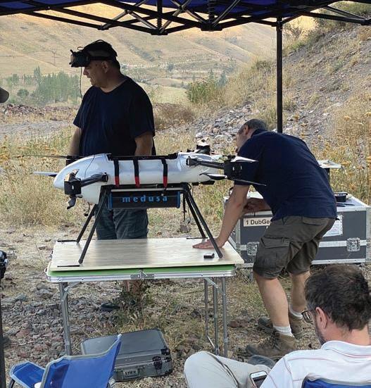
Australia’s AirGeoX provides dronebased geophysical surveys. It has started flying surveys in Tanzania, Kenya, India, and Pakistan and hopes to expand further by partnering with drone operators around the world. From March 2024, AirGeoX will be offering radiometrics surveys utilizing the Medusa 1-litre crystal.
Montreal’s ALS GoldSpot Discoveries was formed in 2023 when ALS Global acquired GoldSpot Discoveries. ALS GoldSpot combines geoscience expertise with AI and data science to solve problems in exploration and mining. ALS now offers services including ground sampling, airborne geophysical acquisition, lab assays, interpretation, and targeting. ALS GoldSpot specializes in triaxial magnetic gradient surveys using its helicopter-borne Multi-Parameter Acquisition Survey System (M- PASS), an all-in-one solution for collecting magnetics, VLF, radiometrics, LiDAR, and photos. Multiple data products can be fed into ALS GoldSpot’s SmartSuite, which is an expert-assisted, AI-driven tool used for exploration mapping and targeting.
Australian Geophysical Services is a ground geophysics company which does surface and downhole EM, IP and MT. The company recently partnered with Quantec Geoscience to provide Titan and Orion surveys in Australia. Working with Nanometrics, the company has successfully deployed passive seismic systems in central Queensland.
Axiom Group is a Saskatchewan consulting firm with four main divisions: exploration, geophysics and geomatics, environment, and energy services. In 2023, Axiom entered into a number of new associations, including collaborations with Ideon Technologies to offer borehole muon tomography services, and Fleet Space Technologies to offer ambient noise tomography services. The company also purchased an additional Xcite TDEM system from New Resolution Geophysics to double its capacity and added a Loupe portable TDEM system. Axiom’s consulting services have expanded through a collaboration with Birch Narrows Dene Development (BNDDI), MMKL Group, and Superior Strategies to create the majority Indigenous-owned company, All3Axiom.
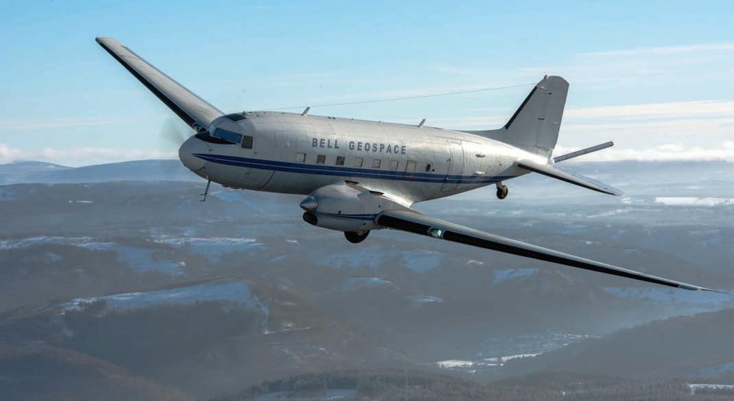
Bell Geospace of Houston is an airborne survey company specializing in full tensor gravity gradiometry. In 2023, the company had a successful first year running the GTz gravimeter, an upgrade of the GT-2A gravimeter by Transparent Earth Geophysics. Bell Geospace has invested in upgrading the LiDAR on the Basler BT-67. Flying the two gravity systems side by side in the same aircraft, along with a magnetometer, and LiDAR when required, delivers a multi-scale, multi-physics solution.
6 EXPLORATION TRENDS & DEVELOPMENTS | MARCH 2024
EXPLORATION TRENDS & DEVELOPMENTS n CORPORATE HIGHLIGHTS
n NRG - New Resolution Geophysics CREDIT: DAVE MOORCROFT
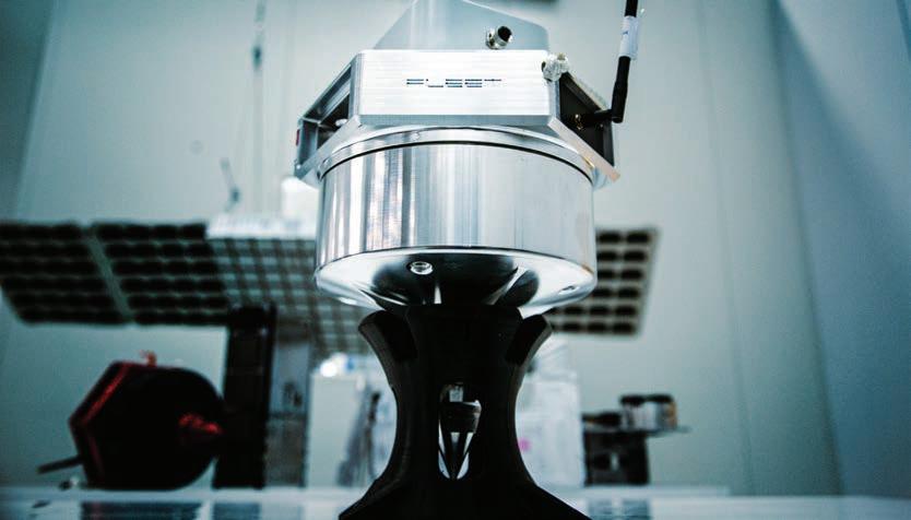
Fleet Space’s patented sensors - Geodes - have been deployed for 250+ surveys across five continents.
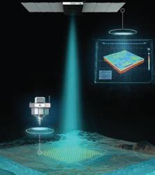
E xosphere by Fleet® uses satellites and geophysical sensors to deliver 3D subsurface models in near real-time.
SPACETECH: A PARADIGM SHIFT IN MINERAL EXPLORATION
 Kevin Ramani, Chief Revenue Officer, Fleet Space Technologies.
An Adelaide, Australia-based space technology company is revolutionizing mineral exploration by delivering 3D subsurface models in days, dramatically accelerating the acquisition and processing of geophysical data used for the selection of drill targets.
Fleet Space Technologies started off in 2015 as a satellite company focusing on industrial IOT solutions such as monitoring oil pipelines, offshore wind turbines, and hydroelectric power lines in remote locations before discovering a profound application in the mining and exploration industry.
“The problem with traditional surveying methods is the time it takes to collect, process and deliver the data to a mining company,” said Fleet Space’s Chief Revenue Officer, Kevin Ramani.
“An array of geophones in the field would sit in the ground for weeks or even months collecting data and then be shipped to a geophysics company where the data would be downloaded, processed and returned to the customer on a flash drive, which is a very antiquated customer experience,”
Fleet Space saw an opportunity to use its satellite constellation in low Earth orbit to collect the data in near real-time without having to remove seismic sensors from the field. Then, the company found that by combining satellite connectivity with Ambient Noise Tomography (ANT) – a low-impact technology for collecting passive seismic data – a solution could be created that delivers subsurface insights to exploration companies in near real-time anywhere on the planet.
“ANT listens to the sound that’s made by the movement of Earth’s tectonic plates and the general hum of the earth as it passes through the subsurface structures at different velocities,” explained Ramani. “The data from the noise is used to generate a 3D image so it’s almost like an ultrasound of the ground that geologists can use to identify fault lines, alteration zones and other geological structures.”
From there, Fleet Space designed and manufactured its patented seis-
mic sensors – called Geodes – which bring together the latest advances in ANT, edge computing, and satellite connectivity to deliver 3D subsurface models of survey areas in days for clients around the world. Today, Fleet Space’s end-to-end mineral exploration technology called ExoSphere has been used to conduct over 250 surveys across five continents for 35 mining companies, including Rio Tinto, Core Lithium, and Barrick Gold.
“We were able to bring the time it takes to collect the data down to as little as 48 hours,” said Ramani. “Our satellites collect the data, so it’s no longer necessary to ship the sensors in the field away. That means you can move them to the next area and rapidly conduct multiple surveys.”
Instead of taking weeks to process the data, Fleet Space can turn around a 3D model within days, allowing customers to make data-driven decisions while the Geodes and crews are still in the field.
“ We were able to bring the time it takes to collect the data down to as little as 48 hours…”
“If they see something of interest at the margin of a surveyed area, they can make a real- time decision to move the Geodes and survey an adjacent area,” noted Ramani. “That’s something unheard of. Nobody else does that. Now, many of our customers are coming back for more surveys and the demand for our service is going through the roof.”
Fleet Space’s achievements aren’t limited to Earth. It was named Australia’s fastest growing company in 2023 and was awarded a contract to build a geophysical device, called SPIDER, to explore the Moon’s subsurface in 2026 as part of NASA’s Commercial Lunar Payload Service initiative. FS
The preceding Joint Venture Article is PROMOTED CONTENT sponsored by Fleet Space Technologies and produced in co-operation with The Northern Miner. Visit: www.fleetspace.com for more information.
JOINT VENTURE ARTICLE
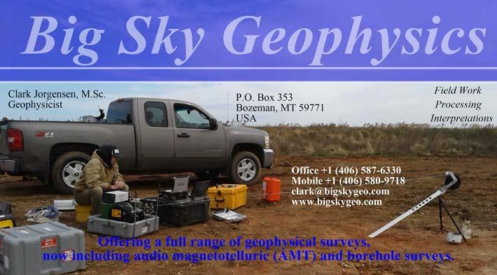
Montana’s Big Sky Geophysics collects many types of geophysical data including ground gravity, magnetics, EM, and IP data. In 2023, Big Sky purchased all of Industrial Imaging’s AMT equipment, including Bill Petrick’s 3D MT inversion program. Big Sky is now conducting 3D natural source AMT surveys, as well as inverting 3D data from other surveys.
ClearView Geophysics of Ontario is a ground geophysics company. In addition to providing ground surveys, it specializes in snowmobile-towed magnetics and EM surveying. ClearView has found that its 200-channel on and off time TDEM system, IMAGEM, is a good replacement for a 50-metre cable Max-Min survey. ClearView couples all of the physical property log surveys with down-hole and side-view camera angles logged up and down the hole. Notable surveys carried out by ClearView include a large gravity survey for the Ontario Geological Survey in southern Ontario and an ATV-towed GPR surveys to map potential graves at suspected First Nations burial sites.
Computational Geosciences of Vancouver provides 3D geophysical modelling and inversion and AI-related services. Its inversion capabilities allows Computational to invert datasets of any size in 3D. In 2023.
Condor Consulting, with offices in Colorado and Vancouver, provides a full range of services for processing, modelling and analysis of geophysical data. In 2023, Condor continued its series of porphyry case studies with the addition of a Red Chris assessment, comprised of a Titan IP-DC resistivity and MT survey, and conventional IP survey. Condor has experienced a marked increase in major programs in and near the Athabasca Basin. Condor continues to support clients in Chile and Colombia working on major copper-gold porphyry systems.
Crone Geophysics & Exploration of Ontario continues to offer surface and borehole EM contract surveys and equipment rentals on projects throughout the world. This includes surface and borehole induction coil (dB/dt), surface and borehole fluxgate (B-field), and surface HT SQUID (B-field) systems. The company saw a significant increase in demand for the Pulse-EM surveys globally, with a notable uptick in Ontario and Quebec. In response to the increased interest in critical metals, Crone undertook a substantial amount of fluxgate (ground and borehole) and HT SQUID (ground) surveys in the search for high-conductance nickel targets. Last year Crone expanded its fleet of auto-
clock synchronization transmitter units and its rental equipment pool.
Saskatchewan’s Dias Geophysical carries out airborne and ground geophysical surveys around the world. The DIAS32 remains the backbone of the patented 3D DCIP system. In February 2023, Dias acquired Discovery International Geophysics to expand its capability and expertise by adding ground-based SQUID EM surveys and high-power borehole EM surveys. The acquisition also gave Dias access to Gap Geophysics’ HeliSAM system. Through partnerships with major clients, Dias’s QMAGT magnetic gradiometer system saw rapid industry adoption in a wide range of survey sizes in 2023. An RSX-5 spectrometer has been added to Dias’ heliborne offerings.
In 2023, EON Geosciences of Montreal continued to grow its aviation fleet, and it now operates a dozen fixed-wing aircraft. It flies services for all survey industries (geophysics, LiDAR, aerial photography, etc.) and continues to provide airborne high-resolution magnetic, gamma-ray spectrometry, gravity, and EM surveys using fixed-wing aircraft and helicopters. EON flew several large aeromagnetic and gamma-ray spectrometric surveys in Quebec, Labrador, Alberta, and several American.
EXIGE Australia provides ultralight airborne data acquisition and geophysical processing services. EXIGE and its partner Coleoptere (France) continue to offer a backpack transportable UAV magnetic mapping platform, VAMPair ‘Colibri’. EXIGE has entered into a partnership with the French national research and technology institute CNRS and its laboratory to commercialize UAVborne GNSS-R technology for soil electrical conductivity, strapdown gravity, soil moisture, and crop heights mapping.
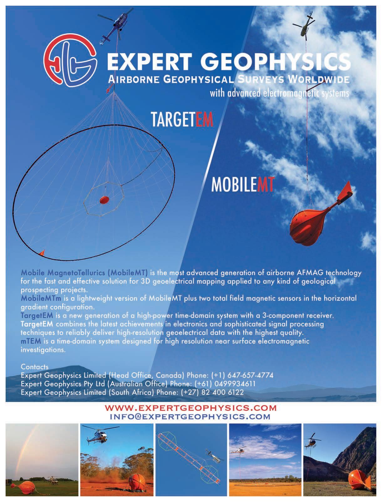
Expert Geophysics, an Ontario airborne company, experienced growth bolstered by an expanding team of experts. The Canadian headquarters has successfully executed surveys across North America, Greenland, and South America. The Australian achieved an industry milestone by conducting the world’s first combined and simultaneous measurement of TDEM, AFMAG, and VLF data using the TargetEM platform. The South African office played a crucial role in establishing the company’s global presence, conducting surveys in Europe and contributing to developments in North Africa, the Middle East, and South Asia. Expert Geophysics’
8 EXPLORATION TRENDS & DEVELOPMENTS | MARCH 2024
EXPLORATION TRENDS & DEVELOPMENTS n CORPORATE HIGHLIGHTS
n Taken amid the frosty landscapes of the Athabasca Basin, Canada, this photograph depicts preparations for a midday survey flight featuring the Xcite loop, despite the frigid temperatures plunging to minus 28 degrees Celsius.
CREDIT: NEW RESOLUTION GEO, DAVID MOORCROFT SENIOR FIELD TECHNICIAN
DISCOVERY-AMS

Fully Automated calibration flights with perfectly consistent manoeuver • Highly robust calibration solutions within 5% across data sets • Industry-standard cesium-vapour magnetometers with Larmor-frequency analog output •
We Fly with
Aero-Magnetic Survey
advanced data processing and interpretation includes inverted resistivity-depth MobileMT data.
Texas-based Fleet Space Technologies provides passive seismic services. Fleet’s geophones (geodes) are connected to satellites which allows the ambient noise tomography (ANT) data to be rapidly transmitted, processed and interpreted in a matter of days rather than months. The final 3D model of the subsurface can extend to 2.5 km in depth. Fleet has experienced rapid growth in Canada and the United States, and expansion into South America.

GDD Instruments of Quebec City is a geophysical equipment manufacturer. The new management group at GDD announced the return of founders, Régis and Réjean Desbiens, as special technological advisers. This strategic move coincides with the company’s relocation to a modern facility in Quebec City.
Geonics of Mississauga, Ont., is a geophysical equipment manufacturer. It specializes in the design, manufacture and service of EM geophysical instrumentation.
Geophysics GPR International

(GPR) is a Quebec-based geophysical company. In 2023, it successfully completed the integration of its sister company, Geosig Inc. This integration has empowered GPR to enhance its offerings across ground, airborne and marine geophysics, specifically catering to the exploration and mining engineering sectors. GPR is celebrating its 50th anniversary in 2024.
Georadis of the Czech Republic is an equipment manufacturer specializing in gamma-ray spectrometers. The company provides custom solutions to mineral exploration and other industries.
Ontario’s Geotech provides EM (VTEM), AFMAG (ZTEM), magnetics, radiometrics, and gravity surveys to clients worldwide. Notable surveys include a large helicopter magnetic and gamma-ray spectrometric survey in Alaska, several EM and magnetic projects for Natural Resources Canada, and two small ZTEM surveys in British Columbia and the Yukon. In 2023, after a three-year pause, Geotech reintroduced survey operations with its VTEM ET (early-time) system for near-surface investigations.
Geotexera of St. John’s, N.L., provides 3D geophysical modelling and inversion services. The software uses unstructured meshes that allow high-resolution topography, geological contacts and surfaces, and borehole information to be added exactly to the models to increase accuracy. The software works with magnetic, gravity, gravity gradiometry, seismic refraction (first-arrival travel times), IP and DC resistivity, magnetotelluric, and muography methods. Other EM methods will be added to the software by the end of 2024.
GeoVision Geosciences of British Columbia is a geophysical consulting and survey company. GeoVision carries out heliborne triaxial magnetic gradiometer and VLF surveys. It also provides processing and interpretation of ASTER and hyperspectral data to map exposed hydrothermal alteration zones.
HiSeis completed numerous seismic surveys for clients in 15 countries. The company specializes in producing quality seismic images across a wide range of hard rock environments. The enhanced geological insight that can be gained is crucial as exploration transitions to more complex and deeper environments in the search for critical metals. Hard rock seismic successfully targets gold, copper, nickel, cobalt, lead, zinc, manganese, uranium, and rare earth metals.
10 EXPLORATION TRENDS & DEVELOPMENTS | MARCH 2024
Be ready for your IP survey sales@iris-instruments.com www.iris-instruments.com EXPLORATION TRENDS & DEVELOPMENTS n CORPORATE HIGHLIGHTS
n MobileMT in China. CREDIT: EXPERT GEOPHYSICS
Ideon Technologies of Vancouver provides hardware and software for muon tomography surveys. Since 2022, its business has tripled. Ideon also received Canada’s Governor General’s Innovation Award, which recognizes transformational Canadian innovations creating a positive impact in Canada and beyond. Throughout 2023, Ideon delivered initial outcomes from borehole and in-mine muon tomography surveys, including multi-physics inversions, in Canada and Australia. This is the highest resolution, straight-line geophysics method available, with proven capability of imaging to a depth of 1 km.
in3D Geoscience of British Columbia is a geophysical consultancy with a focus on maximizing each client’s ability to integrate, visualize, interpret and extract value from exploration data in 3D. It provides geophysical interpretations and recommendations.
Saskatoon’s Initial Exploration Services (IES) is a ground survey company that provides gravity and surface, borehole and underground EM services. In 2023, IES increased its pool of gravity and EM equipment and conducts surveys worldwide.
IRIS Instruments is a manufacturer based in France. It provides EM and IP instruments including the well-known PROMIS, ELREC PRO and FULLWAVER systems.
Klau Geomatics is an Australian instrument manufacturer with a focus on LiDAR. The Brumby LiDAR is wellsuited to airborne geophysics and can be used to create a detailed terrain surface beneath geophysical sensors. Accurate sensor position and orientation are also accomplished. The unit also provides sensor altimetry for precise navigation. It
can be mounted on land vehicles to capture accurate, high-density point clouds.
Lamontagne Geophysics (LGL) of Ontario is the geophysical company that designs and deploys the UTEM system, which it has researched and developed over the past 40 years. It also specializes in software development for geophysical exploration and interpretation. Despite, the passing of Yves Lamontagne in early 2023, LGL is fully operational and is pleased to report 2023 as a busy year for both surface and borehole UTEM surveys.
Australia MAGSPEC Airborne Surveys specializes in detailed airborne magnetic and radiometric data acquisition and processing. It also collects and process regional airborne gravity data. In 2023, MAGSPEC increased its fleet of fixed-wing aircraft and helicopter systems.
ManoTick GeoSolutions (MTGS) of Ontario is a geophysical consultancy providing solutions to all aspects of magnetotelluric projects. This includes training, survey design, contractor selection, 1D, 2D and 3D inversion, and quality control. MTGS now offers joint inversion of natural-source airborne and ground EM data. ManoTick also undertakes research, which is sometimes sponsored by clients.
Medusa Radiometrics of the Netherlands specializes in producing gamma-ray survey sensors for geophysical applications. In addition to providing the airborne and drone-borne survey industry with weight-optimized gamma-ray sensor technology, Medusa provides data processing and QC services. It also provides calibration services of spectral borehole tools from several suppliers. In early 2023, Dr. Steven van der Veeke joined the board of Medusa.
Mira Geoscience of Montreal is a geoscience consulting and software company.
It provides advanced geological modelling, integrated geological-geophysical interpretation, and drillhole targeting services. Mira serves an international client base with a multi-disciplinary team from Canada and Australia. In 2023, Mira launched the Pro Geology industry consortium, following the model of the Pro Geophysics consortium. The new consortium focuses on making advanced tools, particularly AI-based tools, available to industry practitioners through a stable interface, workshops, and training.
Australian Moombarriga Geoscience is a geophysical consultancy providing MT and IP data acquisition, processing and modelling. It uses CGG’s RLM-3D inversion codes for MT, AFMAG, and gravity. This provides the option for joint inversion using cross gradients.
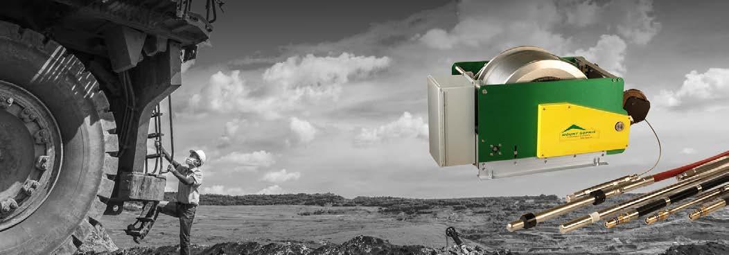
Colorado’s Mount Sopris Instruments manufactures, distributes, and rents geophysical equipment and software for subsurface investigations including mineral exploration.
New Resolution Geophysics (NRG) of South Africa is an airborne survey company providing magnetics, gravity, EMs and radiometrics. NRG’s Xplorer helicopter and Xact fixed-wing gradient magnetic and radiometric systems operate throughout Africa and the Middle East. There are currently multiple Xcite helicopter TDEM systems in operation in Africa, the Middle East, Australasia, and North America. NRG has an exclusive Canadian partnership with the Axiom Group who has sole use of the Xcite system. Recently this partnership expanded to include NRG’s Xplorer NxT helicopter gravity and magnetic system. Xplorer NxT includes NRG’s patented split ring laser gyro, the GT2A total field gravimeter and NRG’s patented Active
MARCH 2024 | EXPLORATION TRENDS & DEVELOPMENTS 11 CORPORATE HIGHLIGHTS n EXPLORATION TRENDS & DEVELOPMENTS

Thermal Control System (ATCS) and greatly improves the drift characteristics and performance of the GT metres. NRG has also expanded its services to the American market with the deployment of a specially modified geophysical AS350 Ecureuil, dedicated exclusively for airborne. In 2023, NRG added the Phoenix Ranger XL LiDAR system for helicopter-mounted operations.
Toronto’s Paterson, Grant & Watson (PGW) is a geophysical consulting firm that provides project management, QA/ QC, data processing, interpretation and training services. The company is in the process of incorporating PGW Arabia to serve the mining and other sectors in the Gulf Co-operation Council (GCC) states, in partnership with Geotech Arabia. In 2023, PGW was the project lead and co-author of the new geological map of Botswana.
Phoenix Geophysics of Toronto provides MT, EM and IP equipment, training and survey commissioning services, as well as full customer support. Phoenix provides ultra-wideband MT equipment. The incorporated remote data transfer feature in its data loggers is becoming an industry standard and is widely employed in remote reference stations and monitoring projects. In 2023, TXU30 transmitters were employed in deep exploration through diverse methods, including TDEM, FDEM, and IP, and were also proven successful in semi-airborne applications. The CSAMT configuration
has been successfully utilized in various commercial applications, including greenfield, brownfield, and urbanized areas.
Ottawa-based Pioneer Exploration Consultants flew numerous drone-based magnetic surveys for mining and exploration companies across North America, Asia, and Latin America. Pioneer also flew helicopter-borne LiDAR over 30 different projects throughout North and South America. Pioneer has acquired a wing pod and LiDAR sensor mount for use on fixed-wing aircraft in regional LiDAR mapping applications.
Precision GeoSurveys of British Columbia specializes in low-level airborne magnetic, radiometric and EM surveys in mountainous terrain. Precision’s exclusive 1TEM time-domain EM survey system offers exceptional detail in near-surface mapping without sacrificing deep search capabilities. In co-operation with Medusa Radiometrics, Precision fielded new and exclusive gamma-ray survey technologies. The data are processed using Medusa’s GAMMAN software is providing exceptional resolution and repeatability.
Quebec’s Prospectair Geosurveys is an airborne geophysical survey company that provides airborne EM surveys using its ProspecTEM helicopter TDEM system, in addition to magnetics and radiometrics. Quality control, data processing, map preparation and reporting are performed by qualified professionals at Dynamic Discovery Geoscience.
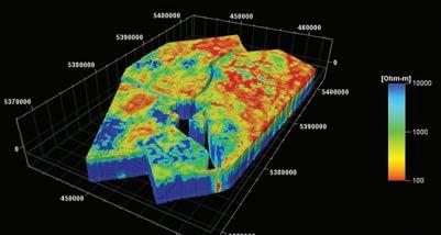
Toronto’s Quantec Geoscience is a ground geophysical company with a focus on distributed array surveys, which it markets as Titan (2D IP/MT) and Orion (3D IP/MT). It also provides ground magnetics surveys in South America.
Radiation Solutions (RSI) of Ontario specializes in nuclear instrumentation for the detection, measurement and analysis of low-level ionizing radiation from both naturally occurring and man-made sources. The company experienced exceptionally high demand for airborne gamma-ray spectrometers in Africa, Australia, Eurasia and North and South America.
RMS Instruments of Ontario is an equipment manufacturer. In 2023, RMS completed multiple contracts for instrumentation for aeromagnetics, based on the DAARC500 aeromagnetic compensation system. Notably, several of the contracts involved new clients and included ancillary instrumentation, aircraft modification kits, and extensive training. Demand for smaller footprint systems, especially for UAV applications, remained reasonably high during the year.
Ontario’s Ronacher McKenzie Geoscience (RMG) provides integrated geological and geophysical services, ranging from desktop modelling and interpretation to field services and drill program management. RMG grew its team of consultants and broadened its range of integrated consulting services to include EM modelling, structural analysis and province-scale geological interpretations. RMG also expanded its geophysical modelling services and now offers 3D MT inversion using the CGG 3D codes. In 2023, RMG interpreted geophysical data and provided geological insight in Saudi Arabia, Turkey, Greece, Mongolia, Alberta, and Quebec.
Sander Geophysics (SGL) of Ontario airborne company providing gravity, magnetic, and radiometric surveys. It also flies surveys with SGFEM, its four-frequency fixed-wing FDEM system. SGL flew numerous surveys with various combinations of gravity, magnetic, radiometric, and EM sensors. SGL also flew a large mineral exploration survey in Oman involving the simultaneous acquisition of gravity, EMs, radiometrics, and magnetics.
Scintrex of Ontario is a geophysical equipment manufacturer focused on gravity and magnetic sensors. It pro-
12 EXPLORATION TRENDS & DEVELOPMENTS | MARCH 2024 EXPLORATION TRENDS & DEVELOPMENTS
EXPLORATION TRENDS & DEVELOPMENTS n CORPORATE HIGHLIGHTS
n Returning from a survey in Namibia, the pilot was awestruck by the endless sand dunes of the Namib Desert. CREDIT: NEW RESOLUTION GEO, DAVID LEIPSIG HELICOPTER PILOT
duces ground, airborne and borehole instruments that are widely used.
Seequent of New Zealand is a software company providing solutions to the geoscience community. Products of note for the mineral exploration industry are Seequent’s Oasis montaj, Leapfrog, and its software portfolio (Res2D, Res3D, Workbench and SPIA) from Aarhus GeoSoftware.
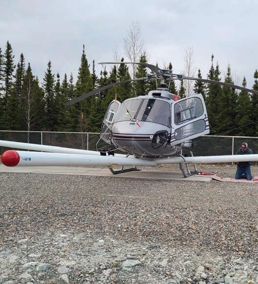
Toronto-based SHA Geophysics provides airborne magnetic surveys and data processing services. In 2023, It carried out surveys in Canada with its Heli-GT geo-referenced three-axis magnetic gradiometer system. The Heli-GT’s entire sensor package – magnetometers, radar altimeter and GPS – is housed in a bird that is towed 25 metres below the helicopter for added safety and greatly reduced magnetic interference. SHA applies its GT-Grid mapping system to the data it collects to achieve full benefit from measured magnetic gradient information. SHA continues to offer the new DAQNAV-I+, a 3D navigation system without data acquisition.
Ontario’s Simcoe Geoscience provides worldwide services including ground magnetics, gravity, EM, IP, MT, seismic reflection and refraction, GPR and borehole logging. Simcoe has added to its pool of wireless Alpha IP systems with additional capacity to create one of the largest global time-domain IP fleets. Simcoe added a new line of instruments to its magnetotelluric and controlled source EM equipment pool. This tech-
nology is core to the operation and effectiveness of the company’s proprietary Omega MT (ultra-broadband magnetotelluric) surveys which are seeing broad usage in mineral exploration and deep imaging searches. The North American office also expanded with the addition of a new borehole services calibration and testing facility and the company opened a new office in the southern hemisphere. Simcoe offers measurement of engineering and mineral exploration parameters, such as soil conductance, in the company’s new on-site laboratory facilities.
Sisprobe of France provides a com-
plete range of passive seismic imaging and monitoring services, including ambient seismic noise tomography and monitoring, horizontal-to-vertical spectral ratio (HVSR), local earthquake tomography (LET), receiver function (RF) imaging, and microseismicity detection and location. In addition to mineral and resource exploration, the portfolio of applications now includes hydrogen and helium exploration projects, and carbon sequestration evaluation.
SJ Geophysics of Vancouver provides ground-based geophysical data acquisition and consulting services internation-

MARCH 2024 | EXPLORATION TRENDS & DEVELOPMENTS 13
CORPORATE HIGHLIGHTS n EXPLORATION TRENDS & DEVELOPMENTS
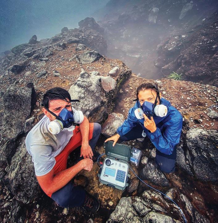
n Magnetotellurics used in volcanology. CREDIT: PHOENIX
ally, specializing in the acquisition of 2D/3D DCIP, EM (surface and borehole), MT, gravity, and magnetic surveys. SJ Geophysics collects the data with its proprietary Volterra systems. These systems enable advanced data acquisition (IP, AMT and EM) from more than one loop simultaneously by using multiple transmitters operating at slightly different base frequencies. In 2023, SJ Geophysics saw a sharp increase in the number of borehole and surface Volterra-EM surveys. Geophysical modelling is undertaken using the UBC-GIF inversion software and a variety of open-source inversion software. In addition to 2D inversion modelling, the company now offers 3D AMT/MT inversion modelling. In 2023, SJ Geophysics conducted field surveys throughout Canada, the United States, Mexico, and Greenland.
SkyTEM of Denmark is an airborne survey company. In 2023, it successfully executed numerous helicopter-borne EM surveys in almost all regions. Aeroscientífica and SkyTEM collaborated to provide helicopter TEM services
to the Brazilian market. Demand for The company’s services persists across all investigation depths, with 50% to 60% of the surveys concentrated in the near-surface (using the SkyEM304) and the remainder extend from surface to depths of approximately 500 metres (employing the SkyTEM312/306HP). In the mining sector, SkyTEM noted a high demand for its HP (high-power) systems that provide exceptional near-surface resolution and substantial depth penetration. Looking toward the future, SkyTEM’s R&D efforts are centred on modularity, ensuring that the design remains flexible to accommodate the diverse goals of each project. SkyTEM Canada has established a strong presence in North America. Primary areas of interest continue to be graphite, nickel, lithium, and vanadium. Moreover, base metals remain in high demand, driven by the ongoing green transition.
Southern Geoscience Consultants (SGC)of Australia provides geophysical services from new survey planning, management, and data QC, to process-

ing, modelling, interpretation, and target generation. SGC can also acquire magnetic, gravity, IP, EM (surface and borehole), and passive seismic data. SGC provides in-house physical property testing of drill core and rock samples.
South Africa’s Spectrem Air is an airborne survey company providing fixedwing EM surveys. The Basler DC-3 platform used for the system is ideally suited for large regional surveys in remote locations.
Tensor Research of Australia provides geophysical software, implementation and training services. The ModelVision potential field software works with airborne, ground and drillhole data for magnetic and gravity interpretation. Tensor also provides, as a service, rock property and depth mapping (RPD Mapping). This AI-driven method provides a new and flexible way of extracting additional targeting information from magnetic data.
Terraplus and Georent of Ontario sell and rent geophysical equipment. In 2023, they continued to expand their inventory of rental equipment, adding several new
+1 801 264 6700
www.technoimaging.com
contact@technoimaging.com
EMVisionTM - 3D large-scale geophysical inversion
The only large-scale 3D AEM inversion with moving sensitivity domain
3D inversion of entire surveys to models with millions of cells, delivered in industry standard formats
RESOLVE - DIGHEM - VTEM - AEROTEM - HELITEM - SkyTEM - TEMPEST - GEOTEM - MEGATEM – SPECTREM - NuTEM
The largest joint 3D gravity and magnetic inversion
3D inversion of regional surveys to models with hundreds of millions of cells, delivered in industry standard formats Gravity - Gravity gradiometry - Magnetics - Magnetic gradiometryJoint inversion with Gramian constraint
The largest joint 3D magnetotelluric and ZTEM inversion
3D inversion of entire surveys to models with millions of cells, delivered in industry standard formats Principle componentFull tensor - Tipper - MT - AMT - ZTEM
3D CSEM inversion
3D inversion of entire surveys to models with millions of cells, delivered in industry standard formats
Frequency-domain CSEM - Time-domain CSEM - Towed Streamer EM - Downhole EM
The only 3D inversion with focusing regularization
To produce sharp images of geological structures
Contract R&D

14 EXPLORATION TRENDS & DEVELOPMENTS | MARCH 2024
EXPLORATION TRENDS & DEVELOPMENTS n CORPORATE HIGHLIGHTS
instruments for UAV, surface, and borehole logging applications. Newly added drone-borne sensors include the MicroHyperspec SWIR 640 UAV hyperspectral imaging system, as well as the D230A UAV gamma-ray spectrometer. Other additions include the new 20-channel Syscal Terra Switch 96 ERT system, MIRA Compact 3D GPR array, and 40TGU-1000 Triple Gamma downhole probe for uranium exploration.
Ontario-based Terraquest provides fixed-wing and helicopter geophysical surveys in 2023. Surveys were completed in North, Central and South America for both mineral exploration and government regional mapping programs. Matrix VLF-EM surveys in eastern North America have shown that the Atlantic Ocean provides an unimpeded VLF-EM signal path, energizing bedrock conductors simultaneously by up to seven VLF stations from Iceland, Europe and the Caribbean. The Government of Newfoundland and Labrador requested VLF-EM data on a large survey flown by Terraquest.
Quebec’s Vision 4K is an airborne geo-
physical service provider with a focus on drone-based surveys. Vision 4K generates high magnetic data at low-altitude. Vision 4K’s service area in 2023 ranged from western Ontario to Nova Scotia and included multiple large-scale lithium properties in the lower James Bay area of Quebec. In addition to geophysical services, Vision 4K now offers high-resolution aerial imagery and LiDAR surveys.
This year Woods Geophysical Consulting of British Columbia has restarted general consultancy after a decade of working exclusively for Discovery International Geophysics. The company specializes in gravity data assessment, BHTEM and moving loop TEM survey recommendations and geological interpretations of resistivity data.
Spain’s Xcalibur is a worldwide provider of airborne and marine geophysical services. Globally, demand for airborne surveying was strong with surveys done in 19 countries. In July 2023, Xcalibur completed the acquisition of all businesses and assets of MPX Geophysics, a Canadian-based com-
pany with a presence in Latin America. This acquisition represents a significant step in Xcalibur’s growth strategy in the Americas. The XMAG system will be available there in early 2024.
Arizona‘s Zonge International provides geophysical services and equipment, including a complete line of IP, AMT, CSAMT, and MT receivers and sensors. These receivers include a distributed MT receiver and an AMT/CSAMT receiver designed for interactive operation. Using Zonge’s Zen receivers, IP data can be collected in arbitrary geometries. It can also be collected with MT information in a single deployment. Zonge conducts MT and CSEM surveys utilizing both 2D and 3D survey configurations. The company provides three-component borehole TEM data collection in the United States in co-operation with Abitibi Geophysics. Zonge also provides high-resolution drone-based magnetics data, with Geometrics MagArrow sensors. Zonge processes and inverts data using a combination of in-house and third-party software.
NEW TOOLS
QL40-nGEN | Non-chemical source neutron tool for in-situ porosity.
40TGU | Triple Gamma, in-situ U3O8% wt. estimation and lithology tool designed specifically for Canadian Uranium Industry.
QL40-ABI43-2G-HT | 175 C high resolution acoustic televiewer.
NEW CAMERAS
www.mountsopris.com
www.alt.lu
MSICAM360-2G | New generation high resolution fully digital borehole camera with on-board solid-state Gyro.
NEW WINCHES
PATHFINDER and EXPLORER high capacity, small footprint, lightweight geophysical logging winches for remote projects and easy-to-ship rentals.
NEW SOFTWARE
PyWellCAD Python library interfaces to WellCAD using automation module
MARCH 2024 | EXPLORATION TRENDS & DEVELOPMENTS 15
New developments from the world leaders in slimline borehole geophysics
Expect the Best...From the Best! CORPORATE HIGHLIGHTS n EXPLORATION TRENDS & DEVELOPMENTS
AIRBORNE SURVEYING
n UAV-based gamma-ray spectrometry (AGP-UAV-gamma) CREDIT: AGP CONSULTING
AIRBORNE MAGNETICS
AGP Consulting has released AGP-MAG, an ultra-lightweight high-precision magnetometer with high-sensitivity rubidium vapour sensors. Four data acquisition channels allow the system to measure magnetic gradients while collecting fluxgate sensor data for real-time compensation. The magnetometer can be used with UAVs, fixed-wing aircraft and helicopters.
AirGeoX has begun testing its TotalMag v1.5 bird, the world’s lightest drone magnetic bird weighing in at 600 grams. Its major advance is a three-component atomic vector magnetometer with a sensitivity of 3 pt/rtHz. It will be commercially available in 2024.
Pioneer Exploration has introduced its Hercules X4 drone to its fleet and has been able to increase production rates by 25% with longer flight times. The new quad-copter is tailored for magnetic surveying with extremely stable and low-noise flight characteristics allowing for highly detailed and clean data.
Precision GeoSurveys’ R&D team continues development of its proprietary degaussing technologies to reduce aircraft-induced magnetic noise in stinger surveys. Precision’s exclusive GoMag 4-sensor triaxial magnetic gradient system has been improved resulting in better flight stability, lower weight, and reduced magnetic noise.
RMS Instruments introduced important enhancements across the DAARC500 family of data acquisition and airborne magnetic compensation systems. Amongst them, new firmware will allow users to customize transfer functions in the system’s front-end. This unique feature allows the in-field tailoring of core signal processing to specific aircraft installation requirements. Other developments include new functionality targeted to magnetic anomaly detection based on both UAV platforms and underwater vehicles, enhancements to real-time monitoring capabilities for ancillary instrumentation, a doubling of sampling/recording rates, and refinements to signal processing to allow seamless integration of airborne magnetics with EM systems.
In the past year, Vision 4K has deployed its drone platform, effectively doubling flight time and payload capacity. The new aircraft can also withstand harsh weather conditions, which Vision 4K hopes will translate into more daily production.
AIRBORNE ELECTROMAGNETICS
AGP Consulting’s newest time-domain EM helicopter system, AGP-TEM, offers high-resolution conductivity data. The AGPTEM system uses a polygonal transmitter waveform, enabling early off-time measurement and effective energizing of deep conductive targets. The system can be easily reconfigured to suit different environments and its depth of investigation can reach 500 metres. The high-speed data acquisition system (AGP-DAS) gathers EM full waveform streamed data together with auxiliary data required for navigation and positioning, and correction of geophysical data (INS). The AGP-DAS is also able to connect a magnetometer, gamma-ray spectrometer and LiDAR to perform multi-parameter airborne surveys.
Dias continued development of its SQUID-based helicopter technology, QAMT, a passive EM (AFMAG) system using three-component, low-temperature SQUID sensors. Field testing has shown great promise of the QAMT system but also showed where modifications had to be made. Major improvements to the instrument have been completed and commercial surveys are offered. Dias plan to use a Skyfront heavy-lift drone to fly UAV SAM surveys at lower frequency and lower cost.
Expert Geophysics began development of a MobileMT system designed to operate on a drone platform. This drone technology will enable the collection of lower frequencies and substantially increase the depth of investigation, particularly beneath terrains with conductive cover. The company also developed and introduced the TargetEM time-domain EM system. This system combines traditional TDEM, AFMAG, and VLF data.
Geotech developed a lightweight ZTEM natural field EM receiver designed to fly at higher elevations but with the same dimensions and specifications as the standard 7.4-metre diameter ZTEM receiver. Geotech hopes to introduce the new ZTEM Lite system to the market in 2024. It has also developed ZTEM signal processing improvements that will extend the number of frequencies available from the current six to nine or more in the 30-to-720 Hz bandwidth. For the VTEM helicopter EM system, Geotech continued development of a new, full stream-
16 EXPLORATION TRENDS & DEVELOPMENTS | MARCH 2024 EXPLORATION TRENDS & DEVELOPMENTS n AIRBORNE SURVEYING
ing data acquisition system. It is also pushing the development of a low-frequency VTEM system, as well as further improvements in signal-to-noise to the current family of VTEM systems using enhanced electronics.
NRG continues to innovate with Xcite’s new, patented receiver suspension. Improvements have resulted in a 2-to-10fold decrease in noise levels. The system is now capable of field switching from 25 Hz to 12.5 Hz. The main advantages of lower base frequencies are increased depth of investigation and improved conductor discrimination and detection in the high-conductance range. NRG has also developed a propriety fast sampling and recording algorithm which allows the magnetic sensor to be mounted on the same plane as the EM transmitter bird so that both the EM and magnetic sensors are at the same height above ground level. This unique configuration ensures that the magnetic sensor is close to the geological source, resulting in a larger signal to noise ratio.
Pioneer Exploration started offering drone-based VLF-EM surveys as a commercial service. Three successful surveys were conducted in Canada. Shallow linear conductive targets were picked up well by this method. The surveys utilized Pioneer’s heavy-lift Hercules X8 drone, which has been engineered for payloads as heavy as 12 kg. With this heavy-lift capability, Pioneer continues to test new drone-based geophysical methods such as radiometrics, TDEM and AFMAG.
Spectrem Air has successfully tested a new EM receiver bird. It will be commissioned in early 2024.

www.new-sense.com
New-Sense Geophysics is a premier geophysical survey company renowned for its expertise in conducting high and steep mountainous terrain. With a focus on safety, precision and innovation, the company specializes in magnetic and radiometric surveys using helicopter and fixed wing platforms. New-Sense Geophysics stands at the forefront with over a million-line km flown, with nearly half above 3000m.
With offices, personnel and equipment strategically located in Canada, the US, Mexico, Peru, Chile, and Argentina, New-Sense Geophysics has established a strong global presence. This positioning allows the company to respond swiftly to project demands.
New-Sense Geophysics has forged strategic partnerships with local helicopter and aircraft operators in each jurisdiction. These collaborations enhance the company’s operational efficiency, providing access to expert aviation services and local knowledge across diverse regions.
New-Sense Geophysics goes above and beyond by offering clients a cutting-edge project dashboard. This portal allows easy access to real-time updates, project status, and track production statistics. More than just a tool for transparency, the dashboard is critical to safe operations. Metrics on the dashboard facilitate monitoring and adherence to project safety KPI (Key Performance Indicators), critical thresholds, performance benchmarks, and production metrics. NewSense Geophysics clientele are avid users of the dashboard, fostering a safe, informed, and collaborative project.
MARCH 2024 | EXPLORATION TRENDS & DEVELOPMENTS 17 EXPLORATION TRENDS & DEVELOPMENTS
PDAC Booth: 212
AIRBORNE SURVEYING n EXPLORATION TRENDS & DEVELOPMENTS
n The Pioneer Exploration crew taking off with their VLF system to conduct a VLF survey in central Newfoundland. CREDIT: MACK EVENDEN


EXPLORATION TRENDS & DEVELOPMENTS
GOLD SPONSORS PATRON SPONSOR
AIRBORNE GRAVITY
AGP Consulting tested the new AGP-GRAV, a strapdown airborne gravimeter. In contrast to traditional airborne surveys using gravimeters with gyro-stabilized inertial platforms, the AGP-GRAV allows a survey to be flown with full drape. This makes it possible to include gravity in multi-parameter surveys along with EM and radiometrics.
AIRBORNE RADIOMETRICS
AGP Consulting has developed the AGP-UAV-gamma, a UAVborne compact gamma-ray spectrometer. It consists of a 0.7-litre CsI detector and is designed for performing detailed surveys over small areas.
Georadis introduced the spectral assay module for the D230A UAV gamma-ray spectrometer. This module utilizes the least squares method together with an advanced algorithm to optimize the calculation of radioelement (K-U-Th) concentrations. It provides better data quality than the traditional stripping ratio method.
Radiation Solutions enhanced its advanced digital spectrometer (ADS) II module. The ADS II offers high- and lowpower modes resulting in energy efficiency or high throughput respectively, making it more versatile. Subtle improvements to the RS-500 instruments increased ease of use and maintenance. For airborne use, the RS-500 systems are now Wi-Fi and Bluetooth enabled. Like the large RSX-4 and RSX-5 packs, the three-crystal RSX-3 is now available in a fire-rated enclosure for those with payload limitations.
 CREDIT: AIRGEOX
OTHER AIRBORNE METHODS
AirGeoX developed an ultra-high-resolution LiDAR/photogrammetry payload on a drone platform. It receives ultra-high-resolution, high accuracy LiDAR and can acquire up to 1,700 ha daily reducing the cost per hectare drastically.
Klau Geomatics ’ Brumby product development is ongoing, including additional LiDAR sensors with increased range and live LiDAR processing to remove obstructions.
Medusa Radiometrics now offers embedded LiDAR-based elevation measurements in its airborne and drone-borne gamma-ray spectrometers. Elevation corrections on the gamma-ray data gathered can now be done in-flight, greatly reducing the need for post-processing. This new feature will be rolled out in early 2024.
EXPLORATION TRENDS & DEVELOPMENTS
SILVER SPONSORS

Condor North Consulting
DGI Geoscience
Mira Geoscience
Paterson, Grant & Watson
Phoenix Geophysics
Radiation Solutions
Scintrex
SJ Geophysics
BRONZE SPONSORS

AGCOS
Computational Geosciences
EMIT
Eon Geosciences
Geonics
Ideon Technologies
New Resolution
Geophysics
Precision Geosurveys
RMS Instruments
Sander Geophysics
Sisprobe
SkyTEM Canada
TechnoImaging
Tensor Research
Zonge International
MARCH 2024 | EXPLORATION TRENDS & DEVELOPMENTS 19 EXPLORATION TRENDS & DEVELOPMENTS
n AirGeoX Drone Magnetic Survey for the Geological Survey of Queensland.
AIRBORNE SURVEYING n EXPLORATION TRENDS & DEVELOPMENTS
GROUND SURVEYING


BOREHOLE GEOPHYSICS
In 2023, Dias added a high-power transmitter that outputs up to 600 A to its borehole TEM system. This has resulted in an increase in borehole, subsurface loop and lateral hole surveys.
In May 2023, Ideon delivered the world’s first borehole muon tomography imaging results at Orano’s McClean Lake project in Saskatchewan. Outcomes matched the existing geological model, defining structural trends and mapping broad alterations surrounding uranium mineralization.
The Mount Sopris borehole QL40-IP tool now includes user-selectable injection/release times between 100 and 2,000 msec, chargeability at two spacings, simultaneous fullwave digitizing at 1.2 micro-volt resolution, and real-time IP inversion to display RTD. In 2024, Mount Sopris is adding gyro capability and simultaneous 360° side-view and downhole view to the MSICAM360 digital borehole video camera system. Throughout 2024, the new QL40-nGen non-radioactive source deuterium-deuterium neutron tool will be in field testing. Specifically designed for the Canadian exploration uranium industry, Mount Sopris is shipping the upgraded, triple gamma tool in 2024. This tool produces low- and highgrade equivalent weight per cent U3O8 logs, along with lithology gamma logs in a single borehole pass.
Scintrex has completed the ‘quick disconnect’ on its Gravilog probe to improve assembly and disassembly in the field. The quick disconnect is a mechanical design enhancement that has the electrical connectors integrated into the probe sections.
In 2023, the SJ Geophysics Volterra-BHEM system was improved, including modifications to the borehole acquisition probes to replace the existing battery with a removable lithium-ion battery. This has increased the battery life of the bore-
20 EXPLORATION TRENDS & DEVELOPMENTS | MARCH 2024 EXPLORATION TRENDS & DEVELOPMENTS
n Percy Sarmiento on the ground in Peru. CREDIT: QUANTEC GEOSCIENCE
ACCURATE SAFE RELIABLE www.QuantecGeo.com Technology forDiscovery Deep Exploration Reliably SurfacetoDepth ResistivitySolutions Structuralmapping &deeptargeting MTSpecialists Celebrating over 20 years Deep Earth Imaging Deep3D Imaging TRUE 3D Fullwaveform distributed DCIP& MT surveys Mine site Imaging Multi-parameter Deep Imaging Surveys EXPLORATION TRENDS & DEVELOPMENTS n GROUND SURVEYING
hole probe well beyond eight hours, as well as shortened the length of the probe, improving portability and usability.
GROUND ELECTROMAGNETICS
In 2023, AGCOS continued to improve its new multifunction EM receiver G8-M. This version of the Gepard-8 EM receiver also supports ground EM methods, has significantly improved data density, data storage, telemetry, system robustness, and is more user-friendly than its predecessor. Wideband multifunction (AT300)and specialized EM current sources (AT-3000 and AT-3000R) have been overhauled for power increases and output current waveform logging accuracy. AGCOS also continues to improve its integrated EM technology, NCSEM. Integration of natural and control source methods with AGCOS hardware and software allows it to effectively target small low-contrast targets.
Crone Geophysics & Exploration routinely updates its EM equipment for faster production and higher data quality. This includes improvements in auto-levelling and stability. The in-house engineering and field survey groups are improving the system response and stability. Crone also made updates to the equipment housing to further reduce wind noise.
During 2023, Geonics continued to develop its G-TEM Lite, a semi-airborne time-domain system with a modified G-TEM time-domain receiver. The system is comprised of a G-TEM Lite receiver mounted on a drone, a ground-based transmitter, and a loop source appropriate for shallow/deep sounding or mineral exploration. The company also focused on GPS synchronization between the receiver and transmitter. This accomplishment furthered the development of the new PROTEM MK2 receiver. The new unit will have enhanced technical specifications compared to the industry standard PROTEM receiver. It is expected to be available for purchase in 2024. Geonics has also designed a considerably lighter version of its EM61-Lite metal and UXO detector for drone application.
Lamontagne Geophysics completed and tested two new UTEM5 HPP transmitters, which were subjected to thirdparty certification for electrical safety. It is LGL’s understanding that this is the first time any geophysical transmitter has received this certification. LGL plans to complete field testing and move them
transmitters into regular survey rotation by early 2024. The peak-to-peak power has been increased to 10 kW from 6 kW (BHUTEM4 Tx).
Southern Geoscience Consultants developed a towed cart platform for the LoupeTEM system to facilitate surveying in open pit environments where foot traffic is not permitted. The company has also acquired the powerful new tTEM system from TEMcompany in Denmark. The tTEM system is an EM profiling system ideally suited for stratigraphic mapping, groundwater studies, mineral exploration, and environmental work. Towed by an ATV or mine-spec UTV, tTEM offers excellent productivity and a superior depth of investigation.
RESISTIVITY AND INDUCED POLARIZATION
AGCOS has improved the effectiveness of TDIP, FDIP and SIP surveys with upgrades to hardware, firmware and software implemented in the new multifunction G8-M data loggers and the AT-300 current source. Integration of these methods with FDEMS-IP and NCSEM has opened up new opportunities for vector IP measurements. In 2023, AGCOS also completed the development of integrated FDEM and IP technology for detailed investigations to a depth of 500 metres, as well as for precise mapping of sub-horizontal geological boundaries. FDEM-IP can also obtain SIP parameters and can be used in areas with high EM noise.
IRIS has launched a new generation of IP receivers called ELREC TERRA. The receiver has 20 channels and is available in a switch version capable of simultaneously communicating between 48, 72, 96 or 120 electrodes. IRIS has also launched its new currentand voltage-regulated transmitter called TIP. It is available in 6 kW or 12 kW. The 6-kW version can be coupled in pairs to achieve power levels of 12 kW and 6,000 V.It promises very good current stability, even when contact resistance varies. This performance means that the IP can be acquired even in on-time, 100% duty cycle injection mode.
Quantec Geoscience has introduced new lithium batteries for its Titan system, providing 20% more usable life at 40% of the weight. These batteries are more reliable for overnight runs and include new efficient chargers. Quantec’s profiling arrays continue to evolve and the TitanPlus improves on EMap by enhancing crossline resolution and providing more robust positioning.
In 2023, Simcoe Geoscience launched its new Scale-able 3D Alpha IP. This technology enables the client to control data density and definition to customize the 3D acquisition within specific budget and exploration requirements. Simcoe also introduced its Ultra Alpha IP in both 2D and 3D modes. This system is equipped with an advanced transmitter to extend the depth of investigation.
MARCH 2024 | EXPLORATION TRENDS & DEVELOPMENTS 21 EXPLORATION TRENDS & DEVELOPMENTS
UTEM5 – BHUTEM real time 3C data from multiple loops wide-band/deep penetration system ISR – Induced Source Resistivity full 3D interpretation lamontagnegeophysics.com GEOPHYSICS LTD GEOPHYSIQUE LTEE LAMONTAGNE GROUND SURVEYING n EXPLORATION TRENDS & DEVELOPMENTS
SJ Geophysics’ in-house R&D team has built the 100% duty cycle SJ IP transmitter, and it was used in field surveys. With 100% duty cycle transmitters, the acquisition of Spectral IP data is now possible and is actively being developed. The next generation of data loggers for the
Volterra acquisition system has reached the advanced development stage with field tests planned for this year.
In 2023, Zonge integrated a Wi-Fi control into its latest IP transmitter allowing for the remote modification of the transmitted frequency and waveform, and for
the generation of arbitrary waveforms (such as pseudo-random binary).
MAGNETOTELLURICS
In 2023, AGCOS continued to improve and upgrade new wideband MT receivers G5-MT (2E+3H) and G8-MT (2E+6H). These versions are more cost-effective for dedicated wideband AMT/MT surveys and have improved data density, data storage, telemetry, and system robustness and are very user-friendly.
In 2023 Dias successfully completed work on MT coil development for expanded capacity, increased portability, and harmony with its cable-free wireless mesh.
Zonge has developed remote Wi-Fi operation of its multifunction AMT/ CSEM receiver utilizing a web server. This means the receiver can be used in unconventional deployments, such as a single operator managing multiple receiver systems, operation from within shelter during adverse weather, or remote operation during long-term deployments. The Wi-Fi structure also allows wireless data transfer and direct migration to data servers. Zonge has also developed a broad range of existing low-noise magnetic field sensors which include AMT/CSAMT antennas designed to measure the field from 1 Hz to 10 KHz and an MT sensor designed to cover the frequency range from 0.0005 to 1 KHz. The most recent additions include a TEM antenna (dB/dt response) with an effective area of 15,000 m² and an ultra-broadband MT antenna that exceeds the noise performance of other clock-only sensors through the entire frequency range.
PHYSICAL PROPERTY MEASUREMENT
Crytur and Georadis continued to develop the CORELA spectral gamma-ray logger for laboratory and in-situ gamma-ray and radioelement (K-U-Th) concentration pattern logging. The CORELA is now available with a conveyor system for fully automated drill core measurements.
OTHER GROUND METHODS
IRIS Instruments offers two different muon telescope technologies for sale –Micromegas and Scintillators. These instruments measure the opacity of the medium through which muons pass. Opacity provides a measure of the density of the medium in space and time.
22 EXPLORATION TRENDS & DEVELOPMENTS | MARCH 2024 EXPLORATION TRENDS & DEVELOPMENTS n GROUND SURVEYING
n A FullWaver unit installed on top of La Soufriere active Volcano, Guadeloupe, West Indies.
CREDIT: IRIS
DATA PROCESSING
ALT has released version 5.7 of its WellCAD software, with an improved log layout engine, streamlined data import, Python script editor, new metadata handling, LithCAD and ToadCAD integration, and many other improvements including several patch releases.
AGP Consulting completed development and testing of a new data acquisition and navigation system, AGP-DAS. The acquisition module logs and displays data from all devices via major communication interfaces, including Ethernet/Wi-Fi and Serial/USB. This allows users to view the flight plan, background maps, and data quality indicators in real-time.
Bell Geospace has developed an efficient geophysical inversion method to transform gravity gradient survey measurements into a robust model of source density. The full-tensor migration approach separates gravity gradient signals originating from various depths, enabling the isolation of distinct signals for geological interpretation. As a result, this technique produces clear depth interval anomaly maps.
ClearView Geophysics has developed a novel way to efficiently acquire and calculate zone B and C for gravity terrain corrections on 50-metre station survey lines.
Computational Geosciences has updated its inversion tools to deliver co-operative inversions between different datasets. It has also developed DCIP data QC and EM coupling removal workflows based on machine learning optimization.
Crone Geophysics & Exploration routinely provides processing and interpretation services on all of its active projects. To this end, it has been developing robust in-house processing software to support existing projects and rental clients.
Dias’ proprietary MT processing, QC, and visualization software saw significant development through the year.
Other notable developments include strategies for handling high-volume data sets. Machine learning now does a first-pass quality control to identify timing issues, data completeness, and EM coupling. Dias’ decoupled mesh is in regular use, and the company has released the Gen2 – Dias32 nodes for heightened onboard processing.
EXIGE developed its SUAVE (software for UAV exploration) software suite through a partnership with Dooferware (South Africa). SUAVE is a commercial software that automates tasks such as UAV survey design and flight management, geophysical data quality control, database compilation, grid maps, and anomaly targeting.
Fleet recently launched three new products related to its ANT data. The Sensitivity Model enables clients to visualize and
MARCH 2024 | EXPLORATION TRENDS & DEVELOPMENTS 23 DATA PROCESSING n EXPLORATION TRENDS & DEVELOPMENTS
n The Basler BT-67 on duty in Europe 2023 CREDIT: BELL GEOSPACE
n TEM in the flight CREDIT: AGP
quantify confidence levels for every 3D model that is generated. The Source Data Pack includes topics such as data quality and all steps taken to generate the 3D model to help explorers understand and have clarity on the measurements. The Data Processing Report is designed to give customers enhanced insight about the ambient noise conditions of the survey.
Geophysics GPR International’s data science division has been actively developing machine learning-based algorithms for seismic data processing.
Geotech has developed a new semi-automated, machine learning-assisted S-cubed approach to mineral targeting using its airborne magnetic and EM data. This approach uses the combination of structural complexity (SC) analysis of magnetic data, self-organizing mapping (SOM) of multi-component data and supervised deep neural network (SDNN) targeting of geophysical data inputs, using known mineral occurrences as training areas.
Throughout 2023, Lamontagne Geophysics continued to test its matched filter processing software, SLProc (Step Loop processing) for the imaging of multi-fold Step Loop EM. The company also updated the MultiLoopGL and the MGEM 3D modelling software to improve workflow. LGL web tools 3C Plotter, Vectorplot, and SVG Vectorplot were also systematically improved.
Medusa provides its gamma-ray spectral analysis technology as a software module that can be integrated as part of the data acquisition/processing software. This module also forms the core of the freely downloadable GAMMAN software, which is tailored to processing large batches of gamma-ray data.

Mira Geoscience has developed new data processing capabilities including automated anomaly detection from airborne EM data and AI-assisted plate modelling to reduce interpretation time. In addition to industry-standard UBC-GIF and VP inversion software, Mira now offers a Geoscience ANALYST interface to all SimPEG inversion codes (full range of potential field inversion types, EM including MT and ZTEM, and DCIP) plus joint inversion of multiple data sets sensitive to the same or different physical properties. All inversion codes can be run locally, cloud-hosted, or on on-premise HPC clusters directly from Geoscience ANALYST.
Paterson, Grant & Watson continued to develop and refine workflows for quality control of large-volume airborne magnetic, radiometric, gravity and TDEM surveys. The firm is improving the application of machine learning to geophysical, geological, topographic, and remote sensing data for geological mapping and mineral potential assessment. New workflows for processing drone magnetic and VLF surveys, from raw field data to final products, have also been introduced. PGW is also offering training to drone providers in the nuances of collecting geophysical data in order to improve the quality of the data.

Newly developed in-house scripts have enhanced Pioneer Exploration’s capability to tackle the challenges associated with drone-based data processing. In particular, these programs have assisted in effectively monitoring data acquisition thus reducing time and money for potential re-flights.
Quantec Geoscience is rewriting its primary processing software platform to incorporate performance and usability improvements, and the company looks forward to its introduction in early 2024.
Radiation Solution’s proprietary RadAssist software has updated and improved the noise adjusted singular value
24 EXPLORATION TRENDS & DEVELOPMENTS | MARCH 2024 EXPLORATION TRENDS & DEVELOPMENTS n DATA PROCESSING
n BGR field team mounting a MS-700 under their drone in Uzbekhistan CREDIT: MEDUSA RADIOMETRICS BV
decomposition (NASVD) algorithm. The automation of NASVD processing and isotope mapping provides an isotope-specific map, simplifying the post-data processing steps required.
In 2023, Seequent provided updates across all of its software products. Res2D saw major user-interface improvements including a suite of new visualization tools. Workbench continued to improve workflow efficiency and user control with new tools, faster visualizations, and better interoperability with Seequent’s Oasis montaj, Central, and Leapfrog. Seequent has also been investing heavily in the development of new cloud capabilities.
In 2023, Simcoe Geoscience developed specialized modelling capabilities for its new Scale-able 3D Alpha IP/resistivity technology.
Sisprobe is developing new algorithms and workflows to improve passive seismic imaging and extract more information from it. Recent developments for ANSWT imaging include HVSR-constrained first layer parameter model, joint inversion of Rayleigh and Love wave (including overtones if applicable), and anisotropy mapping. Sisprobe’s developments in ANSWT imaging improve initial parameters models for LET surveys and microseismicity localization.
SJ Geophysics has developed a new gravity processing software package that takes advantage of the latest techniques to improve the accuracy of corrections and to speed up data processing and quality control. SJ Geophysics has seen a notable increase in the number of AMT surveys being acquired utilizing its proprietary Volterra-MT system. This has enabled a significant improvement in software leading to more robust data QC tools and more efficient processing workflows. SJ has added the ability to apply automatic detection of electric dipole wiring and connection issues in the field to reduce errors.
Southern Geoscience has developed machine learning algorithms (random forest and clustering) tailored for analyzing multi- and hyperspectral satellite or airborne geophysical imagery. These can be applied to assist in identifying and characterizing spectral anomalies. By analyzing multidimensional data, these algorithms can help identify geological anomalies that may indicate the presence of certain minerals, alteration zones, or structures. The analysis and interpretation of radiometric and spectral imagery have been bolstered with dedicated in-house training workshops delivered by Dr. Pavel Jurza and Dr. Mike Hussey.
ModelVision by Tensor Research has been further developed to process, model, invert, and display the results from modern full magnetic tensor surveys. It can use results from RPD Mapping to focus on specific targets and further refine the models with focused inversion.
Terraquest is routinely providing in-phase and quadrature components of the Matrix VLF-EM signal from up to seven global VLF stations. The company offers standard total field amplitude (conductivity) and inversion modelling to create resistivity products which further enhance Matrix data to focus on specific geological signatures.
Zonge can invert the IP data collected with its systems in two dimensions using tools that describe the complete physics of the process, including both IP and EM. This eliminates the impact of EM coupling by utilizing the EM information inherent in IP measurements to both deepen and refine the observed resistivity response.
MARCH 2024 | EXPLORATION TRENDS & DEVELOPMENTS 25 DATA PROCESSING n EXPLORATION TRENDS & DEVELOPMENTS
n Tri-Boom Gradiometer Installed on Astar CREDIT: TERRAQUEST www.naml.at NAML New Austrian Mining Logistics Achieve your ESG goals with NAML, an advanced material handling technology from Austria: Diesel consumption -75% Personnel costs -50 % Tire costs -75 % Maintenance costs -70 % Road maintenance -80 % CO2 emission -75 % Electricity costs and depreciation slightly higher In the example, with a height difference of 400 m and 5 million tons per year, the payback is 2.7 years! Mineral Invest GmbH Gartenstraße 26 4563 Micheldorf, Austria T: +43 670 352 540 0 E: b.kirchner@naml.at
EXPLORATION TRENDS & DEVELOPMENTS
Companies and Websites
Abitibi Geophysics www.ageophysics.com
Advanced Geophysical Operations and Services (AGCOS) www.agcos.ca
Advanced Logic Technology (ALT) www.alt.lu
AGP Consulting www.agpcons.com
AirGeoX www.airgeox.com
ALS GoldSpot Discoveries https://www.alsglobal.com/en/consulting-and-analytics/ data-generation/MPASS
Australian Geophysical Services www.australiangeophysicalservices.com
Axiom Group axiomex.com
Bell Geospace www.bellgeo.com
Big Sky Geophysics www.bigskygeo.com
Canadian Exploration Geophysical Society www.kegsonline.org
ClearView Geophysics www.geophysics.ca
Computational Geosciences www.compgeoinc.com
Condor Consulting www.condorconsult.com
Crone Geophysics & Exploration www.cronegeophysics.com
DGI Geoscience www.dgigeoscience.com
Dias Geophysical www.diasgeo.com
EMIT – ElectroMagnetic Imaging Technology www.electromag.com.au
EON Geosciences www.eongeosciences.com
EXIGE www.exigesa.com
Expert Geophysics www.expertgeophysics.com
Fender Geophysics www.fendergeophysics.com.au
Fleet Space Technologies www.fleetspace.com
Gap Geophysics www.gapgeo.com
GDD Instruments www.gddinstruments.com
Geonics www.geonics.com
Geophysics GPR International (GPR) www.geophysicsgpr.com
Georadis www. georadis.com
Geotech www.geotechairborne.com
Geotexera www.geotexera.com
GeoVision Geosciences www.geovisiongeosciences.ca
HiSeis www.hiseis.com
Ideon Technologies www.ideon.ai
in3D Geoscience www.in3dgeoscience.com
Initial Exploration Services (IES) www.initialexploration.com
IRIS Instruments www.iris-instruments.com
Klau Geomatics www.geomatics.com.au
Abbreviations (for acronyms used in the text)
AFMAG Audio-frequency Magnetic
AGCOS Advanced Geophysical Operations and Services
AGG Airborne gravity gradiometry
AI Artificial Intelligence
AMT Audio-frequency Magnetotelluric
ANSWT Ambient Noise Surface Wave Tomography
ANT Ambient Noise Tomography
ATCS Active Thermal Control System
ATV All-terrain Vehicle
BBMT Broadband MT
BHEM Borehole EM
CSAMT Controlled-source Auto-frequency Magnetotellurics
CsI Caesium Iodide
dB/dt Rate of Change of B with Time
Lamontagne Geophysics www.lamontagnegeophysics.com
MAGSPEC Airborne Surveys www.magspec.com.au
ManoTick GeoSolutions www.manotick-geosolutions.com
Medusa Radiometrics www.medusa-radiometrics.com
Mira Geoscience www.mirageoscience.com
Moombarriga Geoscience www.m-geo.com
Mount Sopris Instruments www.mountsopris.com
New Resolution Geophysics (NRG) www.airbornegeophysics.com
Paterson, Grant & Watson (PGW) www.pgw.ca
Phoenix Geophysics www.phoenix-geophysic.com
Pioneer Exploration Consultants www.pioneerexploration.ca
Planetary Geophysics www.planetarygeophysics.com
Precision GeoSurveys www.precisiongeosurveys.com
Prospectair Geosurveys www.prospectair.ca
Quantec Geoscience www.prospectair.ca
Radiation Solutions www.radiationsolutions.com
RMS Instruments www.rmsinst.com
Rock Bottom Geosciences www.rbgeoscience.com
Ronacher McKenzie Geoscience (RMG) www.RMGeoscience.com
Sander Geophysics (SGL) www.sgl.com
Scintrex www.scintrexltd.com
Seequent www.seequent.com
SHA Geophysics www.shageophysics.com
Simcoe Geoscience www.simcoegeoscience.com
Sisprobe www.sisprobe.com
SJ Geophysics www.sjgeophysics.com
SkyTEM www.skytem.com
Southern Geoscience Consultants (SGC) www. sgc.com.au
Spectrem Air www.Spectrem.co.za
TechnoImaging www.technoimaging.com
Tensor Research www.tensor-research.com.au
Terraplus www.terraplus.ca
Terraquest www.terraquest.ca
Vision 4K www.vision4k.ca
Woods Geophysical Consulting
Xcalibur www.xcaliburmp.com
Zonge International www.zonge.com
DCIP Direct Current Resistivity and Induced Polarization
DES Dipole Electric Sounding
DGGS Division of Geological and Geophysical Surveys
EM Electromagnetic
FD Frequency-domain
FDEM Frequency-domain EM
FDEMS Frequency-domain EM Sounding
FTG Full-tensor Gradiometry
GNSS-R Global Navigation Satellite System Reflectometry
GPR Ground Penetrating Radar
GRCI Geo Resources Consultancy International
HDMI High-definition Multimedia Interface
HPC High-performance Computing
HPP High-powered Production
HVSR Horizontal-to-Vertical Spectral Ratio
Hz Hertz
IES Initial Exploration Services
INS Inertial Navigation System
IP Induced Polarization
LET Local Earthquake Tomography
LiDAR Light Detection and Ranging
MT Magnetotelluric
MVP Magneto Variational Profiling
NASVD Noise Adjusted Singular Value Decomposition
NCSEM Natural and Controlled Source EM
NiMH Nickel-metal Hydrate
PGE Platinum Group Elements
QC Quality Control
RF Receiver Function
RPD Rock Property and Depth
RTD Relaxation Time Distribution
SIP Spectral IP
SQUID Superconducting Quantum Interference Device
TD Time-domain
TDEM Time-domain EM
UAV Unmanned Airborne Vehicle
UXO Unexploded ordnance
V Volt
VES-IP Vertical Electric Sounding IP
VLF Very Low Frequency
VTEM Versatile Time-domain Electromagnetic
ZTEM Z-axis Tipper Electromagnetic
26 EXPLORATION TRENDS & DEVELOPMENTS | MARCH 2024 EXPLORATION TRENDS & DEVELOPMENTS
AXIOM GROUP introduces a revolution in airborne geophysical surveys: Xcite™ and Nxt™. These state-of-the-art technologies by New Resolution Geophysics (NRG™) bring unprecedented precision and efficiency to your exploration efforts.
AXIOM is proud to be an exclusive provider of these services in Canada. Choose AXIOM for cutting-edge technology and a comprehensive data collection toolkit that empowers you to boldly explore.
Xcite™, a new generation of helicopter-borne time-domain electromagnetic (HTDEM) system allows for the simultaneous collection of LiDAR, Radiometrics, Magnetics, and TDEM data. A versatile solution for a thorough understanding of your survey area.
Nxt™, a groundbreaking airborne gravimeter offers precision and detail in every flight, co-collecting magnetic and radiometric data without compromising on survey quality. Ideal for intricate geophysical exploration.
Powered by:
Find out more and book your survey today!

Your Exploration Advantage Find out more www.geotechairborne.com VTEM™ | ZTEM™ | Gravity | Magnetics | Radiometrics | Data Processing | Interpretation T: +1 905 841 5004 E: sales@geotechairborne.com
