All images and photos are author-generated unless otherwise specified.
Part One: Character
Part Two: Landscape Characterisation
2.0 Definition of Landscape Character Type and Character Area
Seven Character Area
Character Area 1: Bradfield Early Enclosure Pastoral
Character Area 2: Dungworth Early Enclosure Pastoral
Character Area 3: Loxley Chase Parliamentary Pastoral
Character Area 4: Damflask Reservoir and Surrounding Woodland
Character Area 5: Loxley River Woodland Corridor
Character Area 6: Loxley Chase Urban Fringe
Character Area 7: Acorn State Urban Area
3.0 Summary 4.0 Reference
Introduction
This report is about the Landscape Characterisation of the studied area, Loxley Valley. There are two terms deemed to be clarified, landscape and landscape character. Firstly, according to the European Landscape Convention in 2006, “landscape means an area, perceived by people, whose character is the result of the action and interaction of natural and/ or human factors”. Secondly, landscape character refers to “a distinct, recognisable and consistent pattern of elements in the landscape that makes one landscape different from another, rather than better or worse” (Swanwick et al., 2002).
Landscape characterisation is a process of identifying unique and distinctive landscape elements, such as the field pattern within a specified area. It is essential because it has been strongly recognized that the uniqueness of places, regions and even countries lies in their landscape characteristics (Selman, 2006). Moreover, understanding the landscape is important as part of the land use planning which significantly affects
people’s quality of life. There are 159 National Character Areas (NCAs) in England, with each is outlined subject to its distinctive landscape character at the national level.
The first part of the report aims at providing a comprehensive character area description of the entire studied area in terms of 9 aspects. In other words, the report will describe Loxley Valley in 9 layers, while exploring the interrelationship between each of them. Methodology includes desktop study and fieldwork. Some of the maps displayed are produced by Geographic Information System (GIS).
The second part of the report starts to map out the landscape character types and landscape character areas of Loxley Valley. These types and areas have distinctive characteristics that separate them from others. They are identified according to the 9 factors examined in Part One.
Part One: Character Area Description of Loxley Valley
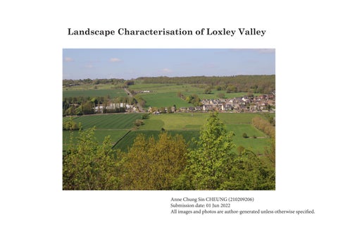
Loxley Valley is located to the northwest of Sheffield city centre. The river flowing through the valley shapes the area to be one of the most vibrant industrial locations in the region in the eighteenth century. Loxley Valley is situated amidst two National Character Areas, namely NCA 51: Dark Peak and NCA 37: Yorkshire Southern Pennine Fringe (Natural England, 2007).
Loxley Valley
Fig. 1.0.1 Loxley Valley Location Map among NCAs (Natural England, 2014)
Fig. 1.0.2 Loxley Valley Location Map adapted from OSMaster Map 2022.
1.1 History
Settlement
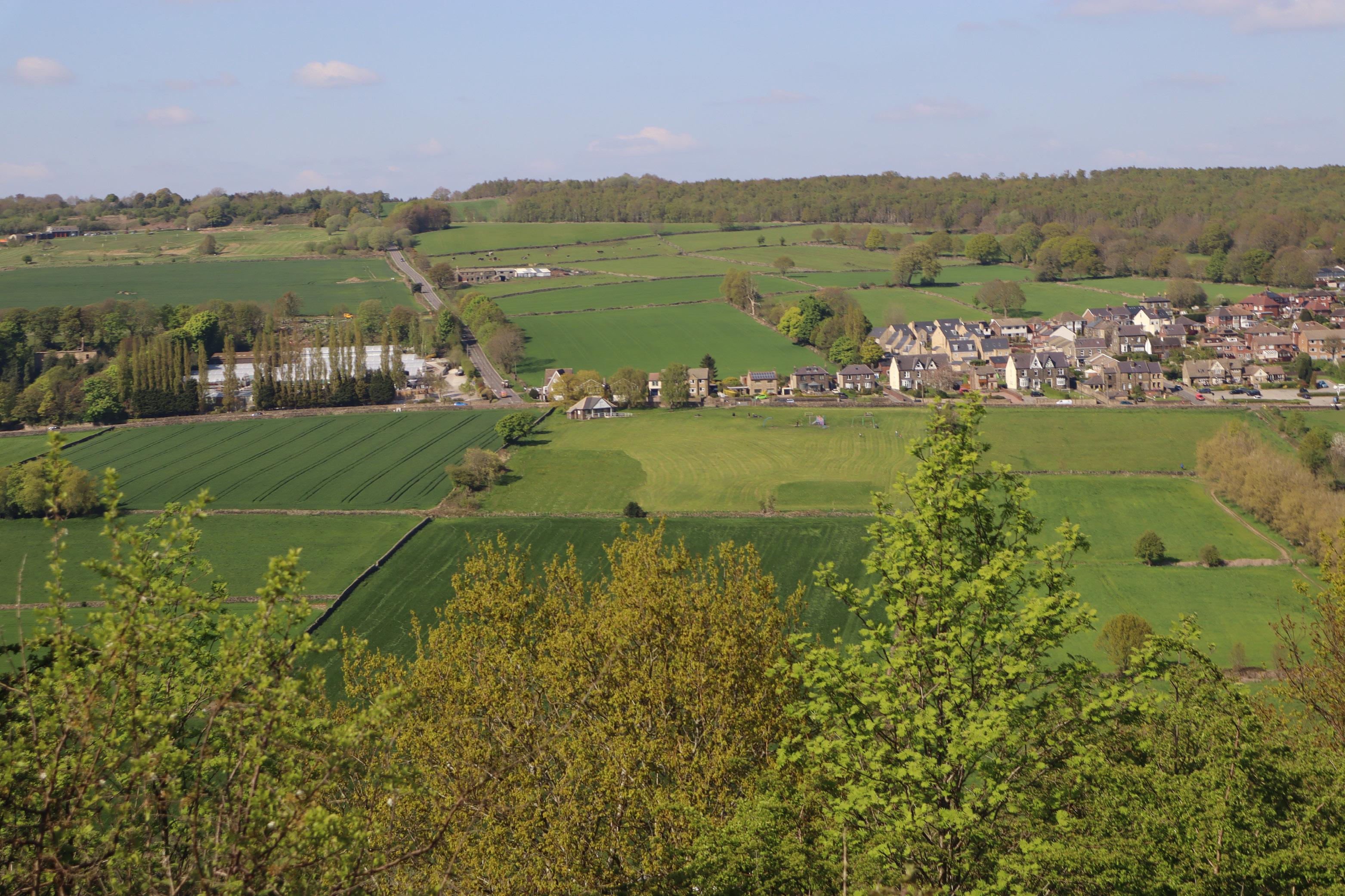
: By 1900, Sheffield had expanded well beyond its medieval boundaries. By c.1938, the previous farmland in Normandale and Studfield Hill (outside site boundary) had transformed into residential areas.
This section will introduce the history of Loxley Valley by pointing out several significant historical incidents or transformation from three aspects: water, land, settlement.
Water:
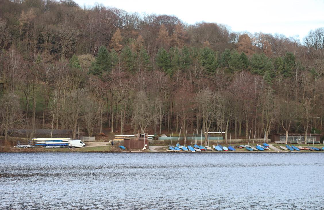
Water is deemed as an essential resource of power for both industrial and domestic uses. Water also possesses the power to shape and destroy a place. In 1864, the Dale Dyke embankment (not within the site boundary) burst, resulting in a death toll of 254. The catastrophe is known as the Great Sheffield Flood (Brindley, 2022). Damflask Reservoir was completed in 1896 to ensure sufficient water power for industrial use and to provide fresh water for domestic use. It is now a place for recreation, walking and fishing (Yorkshire Water, 2022).
Land:
The land of Loxley is dominated by farmland. This links to the history of land enclosure. The enclosure of fields started from the Medieval Period. By the Tudor time, half of the open fields had been enclosed. In Loxley, most of the field of small and irregular boundaries was enclosed by c. 1400. And by 1700, 75% of fields had been enclosed. The Loxley Chase was used to be an hunting parkland and was only enclosed by c.1850, being the latest enclosed field in the area. It is known as Parliamentary Enclosure.
With the expansion of the steel and other metal trades in 1850, industrialisation continued to progress. (South Yorkshire Timescapes, 2007).
Urbanization started to sprawl in suburban areas often in connection with coal mining from the 1920s (Ibid). The settlement area in Stannington was expanded from 1906-1938. The Acorn State, which is near Stannington, was formerly dominated by farmland and became urbanized from the 1980s, and was completely urbanized by recent decades filled with residential housings and schools. Apart from the residential development, starting from the 1950s and onwards, much farmland has been converted into land for recreational uses, such as sports ground or bowling green.
Fig. 1.1 Loxley Valley Historic Map of 1980
1.2 Bedrock Geology
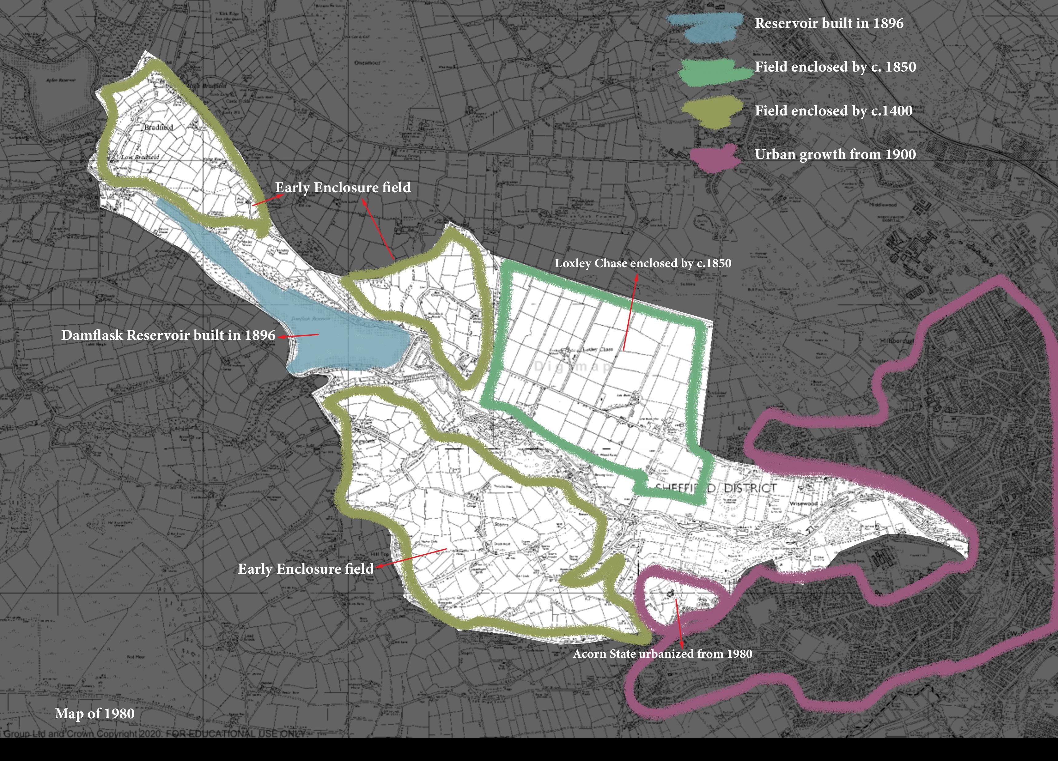
Understanding geology is the gateway to understand the dramatic variations of landscape, for example, how the terrain appears, how the water flows, what types of vegetation grows. Loxley Valley generally comprises different types of sandstone.
To the west of the valley, the underlying geology is called the Millstone Grit Series which are made up of shales and gritstones (Jones, 2000). Particularly, the gritstones originated as coarse sands. The Huddersfield White Rock found in the geology map which are medium, fine grained sandstones, is within the Millstone Grit Series (Huddersfield Geology Group, n.d.). The Huddersfield White Rock is the bedrock with the almost the hardest strength among others in the studied area, contributing to the character of NCA 51 Dark Peak.
To the east of the Millstone Grit Series, Coal Measures are found (Jones, 2000). The coal measures, in this case the Pennine Lower Coal Measures, dominates the bedrock geology of Loxley Valley. Coal measures are made up of sediments deposited in a coastal environment where woods grew and subsequently sank beneath layers of mud and sand (Jones, 2000).
Fig. 1.2.1 Loxley Valley Bedrock Geology Map
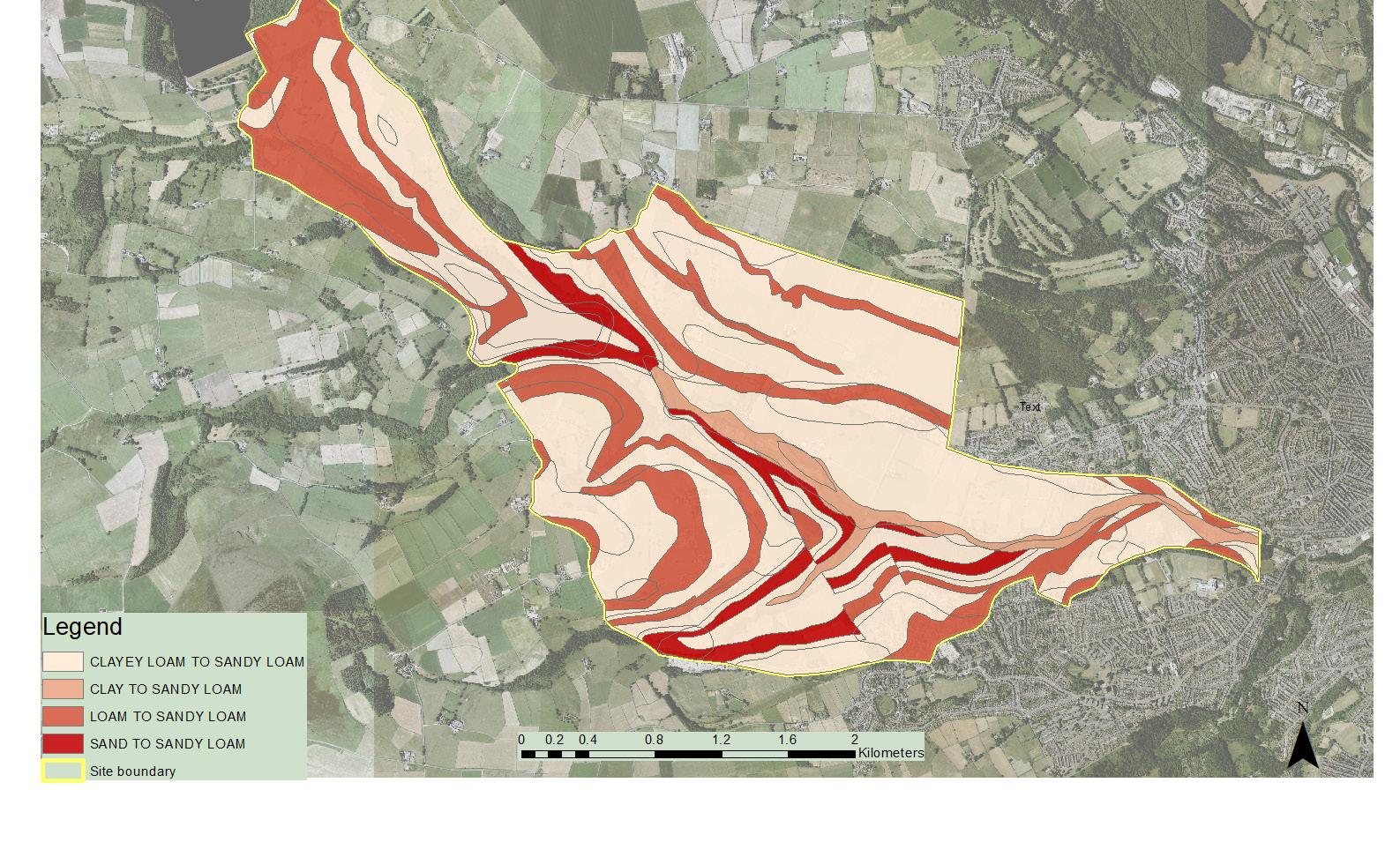
1.3 Soil
All bedrock are mixture of sandstone, mudstone and siltstone in a combination of different proportions.
All soil are mixture of sand, silt and clay that are in vary size. Generally speaking, the soil in the Loxley Valley is displayed in a pattern of alternating bands of clay, loam and sand. Notably, loams are mixtures of clay, sand and silt with each of them in an even constitution. Both Geology Map and Soil Map present a alternating bands pattern, indicating the interrelation between geology and soil.
Sand is bigger in size and thus good-draining because water penetrates faster. But it is low in nutrients. Thus, sandy soil is suitable for vegetation that require low nutrients to grow due to its good-draining qualities. The loose pore spaces allow the expansion of vegetation roots, explaining the broadleaved woodland thriving in the area with higher percentages of sandy loam soil.
Clay is smaller in size and thus bad-draining because it can hold water for a longer time and will induce a higher possibility of flooding. But clay soil is high in nutrients.
Fig. 1.3.1 Loxley Valley Geology Type Map
Fig. 1.3.2 Loxley Valley Soil Map
1.4 Landform
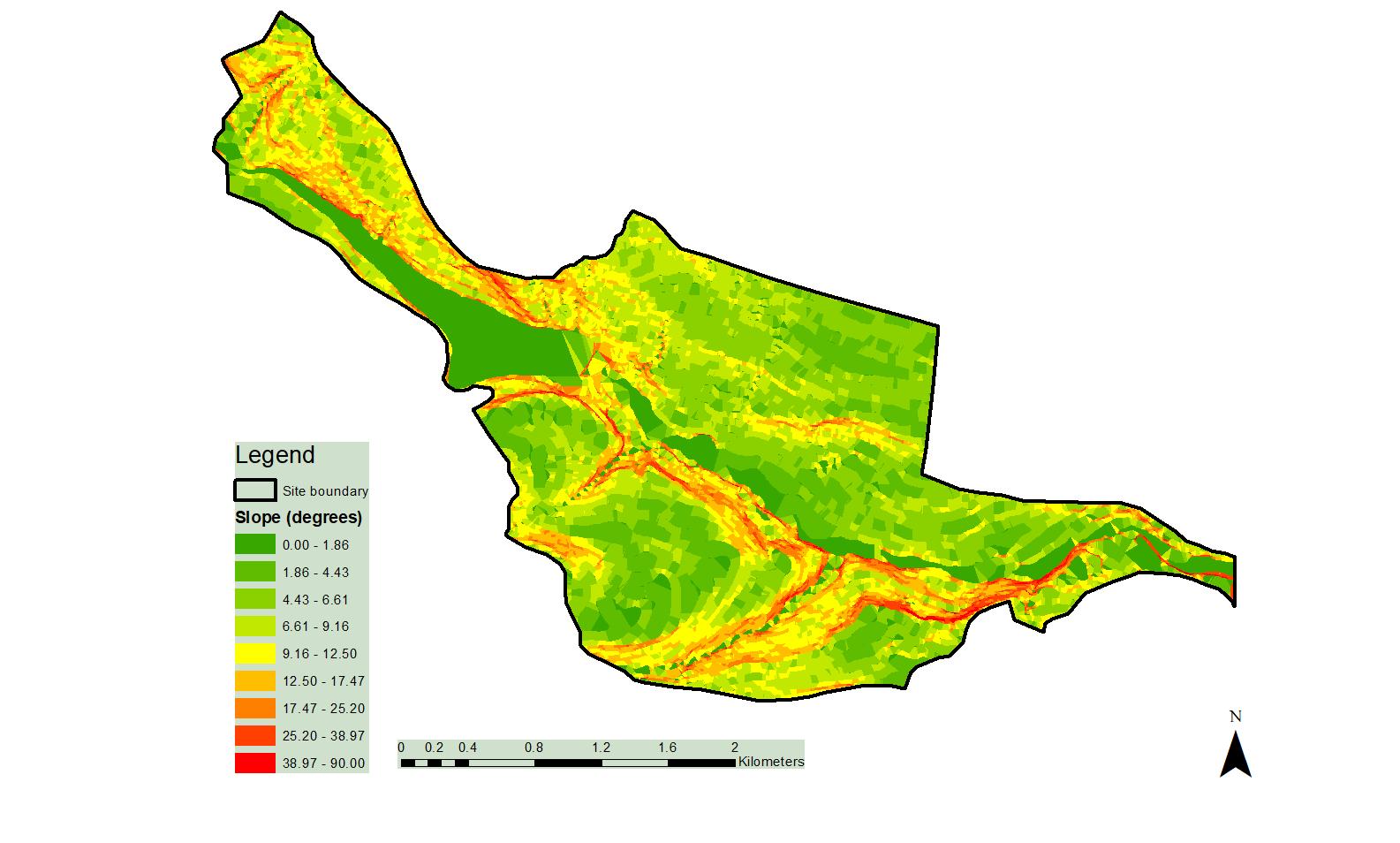
Regarding to altitude, the western part of valley is higher than sea level while the eastern part is more close to sea level. Therefore, the valley flows from west to east.
Regarding to slope (see 1.3.3 Slope Map), most of the area to the northern side and southern side of the valley is covered by green color, indicating less steep slopes on the two sides of the valley. The narrow red strips which appears at edge of valley bottom indicates steeper slopes.
1.4.1 Loxley Valley Elevation Map 1.4.3 Loxley Valley Slope Map 1.4.2 Loxley Valley Aspect Map
Higher in altitude, close to Peak district, cold in weather because the bedrock underneath is harder.
1.5 Water
The history of Loxley Valley is built upon the interaction between water and humans. In other words, water shapes the environment of Loxley Valley, dominates human’s activities, and cultivates the living creatures. The great Sheffield flood in 1864 manifests the enormous power of water to change the landscape.
There are five rivers in Sheffield, Don, Loxley, Riverlin, Porter, Sheaf and Rother. The river flowing across the studied area is River Loxley which lies in the Lower Coal Measures, flowing from west to east. River Loxley is less acidic and less turbulent compared to the river in the northwest upland area. The river corridors and the previous mill dams provide grounds for a more diversified flora and fauna (Sheffield Biodiversity Steering Group, n.d).
Currently, the majority of rivers in the UK have been artificially altered by humans (ibid). In the studied area, most of the watercourse in Loxley are readapted for industrial purpose. Watercourses are manipulated and readapted as mill dams, along with the construction of weirs,offering water powers for industry. On the map, several straight watercourses parallel to the pastoral field boundary are man-made which are used for further irrigation.
The largest water body in the site, the Damflask Reservoir, as a “compensation reservoir” was built in 1896 to maintain a steady flow of loxley river (The Brigantia Archaeological Practice, 2012).
Fig. 1.5.1 Loxley Valley Water Body Map
1.6.1 Vegetation and Wildlife
As shown in the map, Loxley Valley is significantly dominated by the improved grassland, followed by broadleaved woodland. The improved grassland is primely used for animal grazing. The majority of broadleaved woodland is found along River Loxley and the southern side of the river. A small amount of coniferous woodland is found at the fringe of Damflask Reservoir. According to Sheffield Biodiversity Habitat Action Plan (c. 2010), the river corridor plays an important role of refuges for vegetation and wildlife. The river corridor in the studied area is connected to the urban area at its east side, acting as a precious wildlife transitioning link from rural to urban.
The wildlife commonly seen in the river of Sheffield includes, Kingfishers, herons, water vole, whiteclawed crayfish, bullhead, bats and dippers (Ibid). Mallard is often found in the former mill dam.
Fig. 1.6.1.1 Loxley Valley Land Cover Distribution Chart
1.6.2 Vegetation and Landform
Landform will affect the land cover or otherwise the vegetation. Comparing the land slope map with the land cover, it is reasoned that the landform affects what type of vegetation could be grown. The shape of steep slopes tally with the shape of woodland cover while the more gentle slopes tally with the grassland cover. The table below documents the different plant species and the location of their habitat.
Location Vegetation Explanation Source of Information
Higher slopes Generally small oaks Shallow soils with nutrients being washed away (Jones, 2000)
Lower slopes Generally taller oak trees ash, wych elms Deeper soils with rich nutrients (Jones, 2000)
Near water Sycamore, common alder, white willow These are tree species grow in moist, wet conditions On-site observation at mill dam
The local woodlands are not entirely made up of native trees and bushes. Planting of broadleaves and conifers, as well as invasion from adjacent territory by species like the sycamore, have drastically altered them (Jones, 2000).
Fig. 1.6.2.1 Loxley Valley Slope Map
Fig. 1.6.2.1 Loxley Valley Land Cover Map
1.7 Land Use
As shown in the map, the agricultural land, mainly for pastoral farming, dominates the land use in Loxley Valley.
Agricultural production is important not just in terms of food production but also shaping the landscape. In 2018, the utilised agricultural area accounted for 71% of total UK area, however, agriculture generates less than 1% to the UK economy (Department for Environment, Food and Rural Affairs, 2018). Thus, the domination of agricultural land is not preferable in an economic sense, which will induce landscape change that will be addressed in the next layer.
Moreover, the land for recreational use, mostly located at the eastern part of the site, is usually adjoined to agricultural land and built area. Some of them are golf courses, sports grounds and cemeteries, serving urban uses.
The industrial area amid the the woodland involves many derelict factories producing refractory fire bricks, cutlery, etc.
The close proximity to dam indicates the use of water as an energy to run the factory. Some of the old fire works is altered to suit new uses, such as car dealer.
Fig. 1.7.1 Loxley Valley Land Use Map
1.8 Landscape Change
The table shows the most frequently occurring landscape (or land use) changes from 1980 to 2010 in the studied area.
2
3 Vacant land not previously developed Residential 10.16
4 Agricultural land Residential 7.64
5 Agricultural land Rough grassland and bracken 6.03
6
7 Rough grassland and bracken
We are living in an ever-changing environment. There are many drivers for landscape change, for instance:
In Loxley Valley, there is a tendency of increase in woodland and residential areas in the last two decades.
(Natural England, 2012)
As mentioned above, agriculture and forestry is one of the most important drivers of the change lying on the landscape. The map shows an obvious landscape change from agricultural land to forestry. As mentioned in previous layers, Loxley Valley is generally made up of sandy loam which is low in nutrients and not suitable for crop growing. Thus, much of the original agricultural land is of poor quality and not economical-rewarding. The farmer cannot benefit from the agricultural yield nor animal grazing. Thus, there is a transformation of land use from agricultural land to forestry and woodland because forestry is easy to manage and maintain at a lower cost than agricultural land.
However, the enlargement of woodland is beneficial for the environment and achieving sustainable communities (SDG 11). The advantages of woodland include absorption of carbon dioxide and release of oxygen, creating habitat for a wide variety of wildlife and promoting biodiversity.
Apart from the needs of crops and livestocks, the agricultural policy that affects landscape may also vary due to external factors, drawing attention to the Russo-Ukrainian War. Ukraine and Russia produce 30% of the world’s wheat and exports will be halted during the war. Helping UK farmers to produce sufficient crops to keep food affordable is an urgent calling. (Meierhans, 2022).
Hence, there might be a potential demand of changing some of the brownfield in Loxley to agricultural land.
Residential land is the second highest new use in the studied area. In history, twentieth century urban sprawl was a crucial period for a massive change acting on landscape. Nowadays, the spread of development in Loxley Valley is not as vigorous as it was one hundred years ago.
Fig. 1.8.1 Loxley Valley Landscape Change Map
1.9 Policy Area
Policy is a useful tool to plan, manage and regulate the development of an area. There are policies at global, national, regional, local level affecting the development of Loxley Valley.
At national level,
The National Planning Policy Framework (NPPF) lays out the government’s planning policies for England, and establishes a framework for other local development plans to be developed.
Green Belt: NPPF emphasises the importance of Green Belt policy. It is a planning policy to control urban sprawl by “keeping land permanently open” (Ministry of Housing Communities & Local Government, 2021). The studied area is largely covered by the Green Belt which explains the restricted urban growth in Loxley.
At local level:
Peak District: Peak District National Park Local Development Framework lays out the planning policies for conserving the valued characteristics of Peak District for the future generation. The Local Development Framework Core Strategy 2011 lays out the vision, spatial strategy, and core policies for National Park to 2026 (Peak District National Park Authority, 2011).
Neighbourhood plans: it is a bottom-up approach which empowers the community to develop their neighbourhood. The public can share opinions on the location, appearance of residential buildings and infrastructure. It provides an opportunities for the public to join the decision-making process, increasing the recognition of the policies.
Fig. 1.9.1 Loxley Valley Policy Area Map
Part Two: Landscape Characterisation
2.0 Overview: Landscape Character Type & Landscape Character Area
Landscape Character Type
Landscape character types are “distinct types of landscape that are relatively homogeneous in character” (Swanwick et al., 2002, p. 9). They are generic and share similar but consistent character in the aspect of geology, landform, field pattern, historical land use, etc (Ibid). One single character type may appear in different parts of the UK.
Landscape Character Area
Landscape character areas are unique areas which “have their own individual character and identity”. Although they may share same generic landscape characteristics with other areas, each character area differentiates themselves by making them place-specific.Thus, the name of a particular place, such as Bradfield, will be added to the name of a landscape character area.
Fig. 2.0.1 Loxley Valley Landscape Character Area Map
Character Area 1. Bradfield Early Enclosure Pastoral
Key Characterisitic Forces for Change
1. Southwest-facing slope
2. Irregular and small field pattern
3. Early enclosure fields for pastoral farming
4. Relatively more clusters of trees, shrubs. Some trees are seen on the boundary
5. Small rural dwellings are scattered
Character Area Description
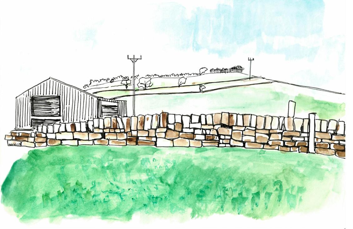
Bradfield Early Enclosure Pastoral comprises High Bradfield, Low Bradfield and a small part of Holdworth. Bradfield is generally an upland area high in altitude and has an intimate connection to the Peak District.The land is dominated by agricultural land and a small portion of deciduous woodland. The irregular and small enclosure field is used for pastoral farming, such as grazing sheep. Small rural dwellings are scattered around the area, rendering a sense of community. The listed historical buildings in High Bradfield, such as St Nicholas Church, the motte and bailey reveal the affluent past of the area. Relatively more clusters of trees and shrubs, including Aesculus hippocastanum, Ilex aquifolium, Lonicera are found in the area compared to Character Area 3. Trees are usually seen on the field boundary.
• Changing preference of land use
• Increasing visitors to Peak District
National Park
Fig. 2.1.1 Bradfield Early Enclosure Pastoral diagram
Fig. 2.1.2 Close up of St. Nicholas church, Bradfield.
Fig. 2.1.3 Sketch of Motte and trees, Bradfield
Fig. 2.1.4 St. Nicholas church, Bradfield.
Fig. 2.1.5 Langlands Cafe
Fig. 2.1.6 Surroundings of Motte and Bailey, Bradfield
Fig. 2.1.7 Boundary road of Bradfield (Bradfield) and Loxley Chase (Right)
Character Area 2. Dungworth Early Enclosure Pastoral
Key Characterisitic Forces for Change
1. Complex undulating rough topography
2. Combination of large and small irregular field pattern
3. Early enclosure fields for pastoral grazing
4. Relatively more tree covers
5. Small rural villages, such as Dungworth
Character Area Description
The area is characterized by a complex landscape. Many factors contribute to the complex landscape. The area consists of rolling and steep slopes of multi-facing. Field size in the area varies from small to large. The field is divided by mostly dry stone walls and fewer fences or hedges. Different from Character Areas 1 and 3, the field is also used for grazing livestock, but mostly horses and cows, reflecting the horsey culture in the area. The area has relatively more tree covers, mainly deciduous, compared to the Character Area 3. Streams are running down the slopes. The small rural villages, such as Dungworth give the area a sense of living. The roads and paths are rather sinuous, further contributing to the complexity of the area.
• Pressure on viability of pastoral agriculture: low economic benefits of the agriculture industry forces the company like “Our Cow Molly” to diversify the dairy products by incorporating ice-cream to make ends meet
• Pressure on agriculture policy caused by Brexit & Russo-Ukrainian war
• Urban expansion
Fig. 2.2.3 Sketch of Dungworth Early Enclosure Pastoral; irregular field boundaries
Fig. 2.2.1 Dungworth Early Enclosure Pastoral diagram
Fig. 2.2.2 Rolling grassland, Dungworth
Fig. 2.2.4 Dungworth Early Enclosure Pastoral overview
Fig. 2.2.5 Horse grazing
Fig. 2.2.6 Our Cow Molly ice cream shop
Fig. 2.1.7 Dwellings of Dungworth
Character Area 3. Loxley Chase Parliamentary Pastoral
Key Characterisitic Forces for Change
1. Consistently south-facing, steady and gentle slopes
2. Large and regular field pattern
3. Parliamentary enclosure fields for pastoral farming, mainly sheep
4. Undeveloped skylines
5. Relatively few trees
6. Straight artificial drainages
Character Area Description
The area is dominated by the parliamentary enclosure fields, which are featured as large and regular field patterns with straight field boundaries. The boundary lines are marked by dry stone walls, hedges and fences.The land is used for livestock grazing, primarily sheep. The name of “Loxley Chase” reveals the past of land as an unenclosed hunting park. Loxley Chase Parliamentary Pastoral is the latest area to be enclosed compared to others (Brindley, 2022). The whole area is covered by consistently-steady, gentle, south-facing slopes, with relatively few trees, resulting in an undeveloped skyline. A few individual trees found are on the boundary. Several man-made drainage ditches are flowing towards the valley parallel to the field boundaries. They are used to drain the poor-draining and water-locked moorland. The area is open, tranquil, calm, and regular with less human existence. Only a few scattered farm buildings are observed.
• Proximity to urban area may result in conversion of pasture to recreational land
• Pressure on agriculture policy caused by Brexit & Russo-Ukrainian war
Fig. 2.3.3 Overview of Loxley Chase parliamentary pastoral
Fig. 2.3.5
Fig. 2.3.4 Sketches of fields
Character Area 4. Damflask Reservoir and Surrounding Woodland
Key Characterisitic Forces for Change
1. Man-made reservoir: Damflask Reservoir
2. Water reservoir surrounded by deciduous and coniferous woodland
3. Within Peak District National Park
4. Open sights, windy, quiet
• Increasing visitors to Peak District National Park
• Changing demand of water supply for both industrial use and domestic use will affect people’s use of this area
• Increasing wants of water sports, such as angling, sailing, rowing, etc (Yorkshire Water, 2022)
Character Area Description
The area is dominantly covered by Damflask Reservoir and the surrounding woodland, both deciduous and coniferous. The existence of Damflask Reservoir manifests the importance of water as an essential source of power for Loxley and Sheffield. It is now a spot for recreational activities, such as walking around the perimeter of the reservoir and fishing. The area facing the reservoir has open sights and a quiet ambience.
Fig. 2.4.2 Sketches of Damflask Reservoir
Fig. 2.4.1 Character Area 4 diagram
Fig. 2.4.3
Fig. 2.4.5
Fig. 2.4.6
Character Area 5. Loxley River Woodland Corridor
Key Characterisitic Forces for Change
1. Narrow river valley
2. Dense deciduous woodland along both sides of river; has patches of ancient woodland
3. Industrially-developed: mill dams and derelict works
4. Wild, rough, cool, quiet, dark character
Character Area Description
Loxley River Woodland Corridor is located at the bottom of Loxley Valley. The River Loxley dominates the landscape
The area has a combination of man-made and natural elements owing to the industrial past. The mill pond and some of the derelict works indicate the area’s industrial past and the history of utilizing water to generate energy. It also shows human’s efforts to control the river.
The land is predominantly covered by deciduous woodland which provides a habitat for wildlife and contributes to the high biodiversity. Vegetation that is adapted to moist conditions, such as Acer psuedoplatanus, Alnus glutinosa, Salix alba, etc is prevalent in the area. The area has a sense of quiet, cool and dark. People feel enclosed by tall and dense trees. The sound made by rivers, birds, and wildlife surrounds the area.
• Pressures on potential housing development on brownfield site
• Historical reason: Industrial Revolution, Overall decline of UK steel industry
• Adaptive reuse of old and dilapidated factories
Fig. 2.5.5
Fig. 2.5.1
Fig. 2.5.2 Old works
Fig. 2.5.3
Fig. 2.5.4 Loxley Fishery
Character Area 5.
Character Area 5.
Loxley River Woodland Corridor
Loxley River Woodland Corridor
Section A1-A2
Character Area 6. Loxley Chase Urban Fringe
Key Characterisitic Forces for Change
1. Grasslands for partially pastoral farming and partially recreational uses
2. Suburban housings
3. Aside a main road that brings people in
4. Balanced character between man and nature
Character Area Description
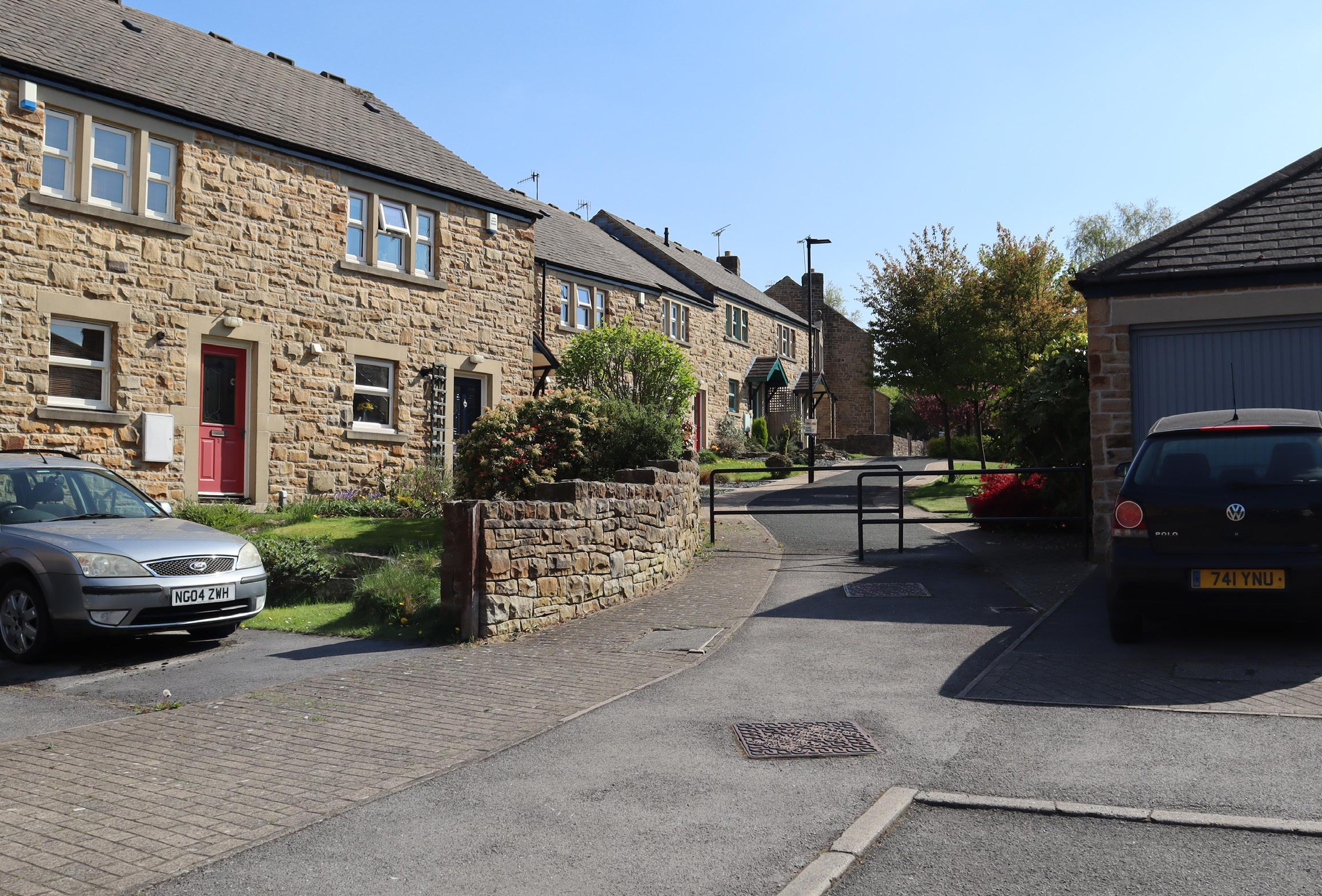
The area is situated at the fringe between urban area and Loxley Chase pastures. It is covered by grasslands and suburban buildings. Some of the grasslands are used for pastoral farming similar to Character Area 3, but many of them are used to serve urban uses, such as cemetery and sports ground. The area demonstrates a gradual change from rural to urban. The area is beside a main road, Loxley Road which brings people into Loxley Valley. The area maintains a good balance between man and nature.
• Urban expansion
• Changing preference of grassland uses due to a close proximity with urban area
Fig. 2.6.5 Cemetary in Loxley Chase Urban Fringe. Photo from Brindley, P.
Fig. 2.6.4 Google Street View of Loxley Chase Urban Fringe.
Character Area 7.
Acorn
State Urban Area
Key Characterisitic Forces for Change
1. North-facing slopes
2. Residential area with medium density
3. Undergone obvious and rapid landscape change since the 1980s: residential development
4. Residential housings are featured by the local sandstone materials
5. Nearly unified housing appearance
Character Area Description
The Acorn State Urban Area has become urbanized since the 1980s. The area is just outside the Green Belt area, thus it has little limitation on buildings developments. The area is dominated by residential buildings sitting on a north-facing slope. The buildings are built around a junior school center. Most of the dwellings are of similar, almost unified appearance. They use the vernacular sandstone materials to preserve the local character. The building is of two storeys with a hip roof. The area maintains a balance between open space and dwellings, thus the area does not feel compacted.
• Urban expansion
• Green Belt policy to stop the urban sprawl
In conclusion, the report is undergoing the process of landscape characterisation of Loxley Valley. This is the first and foundational stages for Landscape Character Assessment in real practice. Landscape characterisation is based on desktop research and field survey. The result of landscape characterisation, that is the content of this report, is useful for policy makers to make judgment and lay out policy for the landscape.
It is noted that sources of information used above may not be the most updated one, given that we are living in an ever-changing environment. Our landscape is not only shaped by physical factors, such as geology, soil and landform, but also human intervention. One should particularly keep an eye on the analysis of the key pressures for landscape change as they frequently changed over time. For example, the hot-debated issue that affects agricultural policy shifts from Brexit in 2017 to the Russo-Ukrainian war in 2022. Therefore, it is important to know that our landscape is shaped by numerous factors.
Brindley, P. (2022). History of the Loxley Valley. Available at: History of the Loxley Valley (blackboardcdn.com) (Accessed 1 Jun 2022).
Brindley, P. (2022). South Yorkshire Historic Environment Characterisation. Available at: OpenLayers example (shef.ac.uk). (Accessed 31 May 2022).
Department for Environment, Food and Rural Affairs, Department of Agriculture, Environment and Rural Affairs (Northern Ireland), Welsh Government, Knowledge and Analytical Services and The Scottish Government, Rural and Environment Science and Analytical Service. (2018) Agriculture in the United Kingdom. p. 5. Available at: AUK_2018_09jul19a.pdf (publishing.service.gov.uk) (Accessed: 27 May 2022).
Huddersfield Geology Group. (n.d.). Local Geology: Rock Minerals. Available at: Rock Minerals – Huddersfield Geology Group. (Accessed 27 May 2022).
Jones, M. and Warburton, B. (2000) The making of the South Yorkshire landscapes : a popular guide to the history of the county’s countryside and townscapes. Barnsley: Wharncliffe.
Meierhans, J. (2022) ‘Farmers warn Ukraine war will hit UK food prices’, BBC News, 10 March. Available at: Farmers warn Ukraine war will hit UK food prices - BBC News (Accessed: 27 May 2022).
Ministry of Housing, Communities & Local Government (2019) Land Use Change Statistics in England: 2017-18. Available at: Land_Use_Change_Statistics_England_2017-18.pdf (publishing.service.gov.uk) (Accessed: 27 May 2022).
Ministry of Housing, Communities & Local Government. (2021). National Planning Policy Framework. Available at: National Planning Policy Framework (publishing.service.gov.uk) (Accessed 29 May 2022). Peak District National Park Authority. (2011). Peak District National Park Local Development Framework. Available at: Local Development Framework Core Strategy - Final Errata 2 (30/11/11) (peakdistrict.gov.uk) (Accessed 29 May 2022).
Natural England. (2007). NCA 37 profile. Available at: 60173 Vol 3 (blackboardcdn.com) (Accessed 29 May 2022).
Natural England. (2012). Landscape: beyond the view. p. 14. Available at: Landscape: beyond the view (naturalengland.org.uk) (Accessed: 27 May 2022).
Natural England. (2014). National Character Area profiles. Available at: National Character Area profiles - GOV.UK (www.gov.uk) ((Accessed 29 May 2022).
Selman, P.H. and Royal Town Planning Institute (2006) Planning at the landscape scale. London: Routledge.
South Yorkshire Timescape. (2007). South Yorkshire Historic Environment Characterisation. Available at: South Yorkshire Historic Environment Characterisation | South Yorkshire Historic Environment Characterisation (sytimescapes.org.uk) (Accessed 31May 2022).
Sheffield Biodiversity Steering Group. (c. 2010s). Rivers and Running Water: Habitat Action Plan. Available at: https://vle.shef.ac.uk/ultra/courses/_98006_1/cl/outline (Accessed 29 May 2022).
Swanwick, C., & Land Use Consultants. (2002). Landscape Character Assessment. Guidance for England and Scotland. Edinburgh: Scottish Natural Heritage.
The Brigantia Archaeological Practice. (2012). WEIRS on the RIVER LOXLEY, BRADFIELD, SHEFFIELD, SOUTH YORKSHIRE: HERITAGE STATEMENT. Available at: https://dcrt.org.uk/wp-content/uploads/2013/04/LOXLEY_WEIRS_STATEMENT.pdf (Accessed 29 May 2022).
Yorkshire Water. (2022). Damflask Reservoir. Available at: Yorkshire Water - Damflask Reservoir. (Accessed 31May 2022).
4.0 Reference
Reference for images and photos
All photos and sketches area author-generated unless otherwise specified.
Fig. 1.6.1.3b: Sheffieldwildlife. (2009) Patch update 11/02/09. Available at: loxley valley – Sheffield Wildlife (wordpress.com) (Accessed 29 May 2022).
Fig. 1.6.1.3c: Sheffieldwildlife. (2009) Patch update 11/02/09. Available at: loxley valley – Sheffield Wildlife (wordpress.com) (Accessed 29 May 2022).
Fig. 1.6.1.3d: Mella, P. (2009) Grey Heron. Available at: Grey Heron | Loxley Valley, Sheffield, May 2009 | Pete Mella | Flickr (Accessed 29 May 2022).
Fig. 1.6.1.3e: Corbidge, C. (2022)
Common Redstart. Available at: Common Redstart by Carl Corbidge - BirdGuides (Accessed 29 May 2022).
All maps used are adapted from a base map using the follows:
Fig. 1.1: Landmark Information Group. (1980). Ordnance Survey County Series 1:10560, Map of 1980s; Using: EDINA Historic Digimap Service, digimap.edina.ac.uk, Downloaded: Jun 2022.
Fig. 1.2.1: British Geological Survey. (2022). Offshore Geology; Using: EDINA Geology Digimap Service, digimap. edina.ac.uk, Downloaded: Jun 2022.
Fig. 1.3.1: British Geological Survey. (2022). Offshore Geology; Using: EDINA Geology Digimap Service, digimap. edina.ac.uk, Downloaded: Jun 2022.
Fig. 1.3.2: British Geological Survey. (2022). Offshore Geology; Using: EDINA Geology Digimap Service, digimap. edina.ac.uk, Downloaded: Jun 2022.
Fig. 1.4.1: Blackboard. (2022). NTM Data; Using: EDINA Geology Digimap Service, digimap. edina.ac.uk, Downloaded: Jun 2022.
Fig. 1.4.2: Blackboard. (2022). NTM Data; Using: EDINA Geology Digimap Service, digimap. edina.ac.uk, Downloaded: Jun 2022.
Fig. 1.4.3: Blackboard. (2022). NTM Data; Using: EDINA Geology Digimap Service, digimap. edina.ac.uk, Downloaded: Jun 2022.
Fig. 1.5.1: British Geological Survey. (2022). Offshore Geology: drift; Using: EDINA Geology Digimap Service, digimap. edina. ac.uk, Downloaded: Jun 2022.
Fig. 1.5.1: Ordnance Survey. (2022). Aerial photo; Using: EDINA Geology Digimap Service, digimap. edina.ac.uk, Downloaded: Jun 2022.
Fig. 1.6.1.2: Blackboard. (2022). Data 3, Downloaded: Jun 2022.
Fig. 1.6.2.1: Blackboard. (2022). Data 3, Downloaded: Jun 2022.
Fig. 1.6.2.1: Blackboard. (2022). NTM Data; Using: EDINA Geology Digimap Service, digimap. edina.ac.uk, Downloaded: Jun 2022.
Fig. 1.7.1: Verisk. (2022). UK Land; Using: EDINA Geology Digimap Service, digimap. edina.ac.uk, Downloaded: Jun 2022.
Fig. 1.8.1: Blackboard. (2022). Data 9, Downloaded: Jun 2022.
Fig. 1.9.1: Blackboard. (2022). Policy area data, Downloaded: Jun 2022.
Sections for Character Area 5 are adapted from Environment Agency. (2022). Lidar DTM and DSM Data; Using: EDINA Geology Digimap Service, digimap. edina.ac.uk, Downloaded: Jun 2022.
All aerial photos backdrops are adapted from Ordnance Survey. (2022). Aerial photo; Using: EDINA Geology Digimap Service, digimap. edina.ac.uk, Downloaded: Jun 2022.