Urban Design and Architecture Portfolio
Urban Design and Landscape Portfolio
ALESSANDRA BALDO
In fo
Work
Landscape Arch
02/2021-Present
Alessandra Baldo
(ARB registered)
Email: Alesbaldo@hotmail.com

Publication
Turkington Martin (Landscape & urban design, London)
Sk ills
Freelancer
06/2020-11/2020
Architect
Urban Designer
05/2018-01/2020
Internship
08/2017-04/2018
Internship
05/2017-07/2017
Workshop
07/2015
09/2015
Education
11/2019-06/2020
09/2009-01/2017
Spazio, Tempo, Utopia. Scritti e progetti per Sewing a small town, 2015-2016 (Alberto Bologna) F.Angeli Editore.
•
• Completion report for planning
Concept and tender desogn for playgorunds
•
Public ream and park design ( hard-landscape and soft-landscape)
Philip Cave associates (Landscape & urban design, London)
Native Language Italian
Other Language English
•Reading
Concept design for public spaces
Designer hard landscape design (concept and technical detail)
MRG Studio (Landscape & urban design, London)
•
Concept design for public spaces
• Designer hard landscape design (concept and technical detail)
• Paving design and strategy
•Speaking
•Writing
Grade 7 Trinity; B2 Cambrige ESOL
•
German
•
• Working throughout all RIBA stages
•
Completion DAS report for planning
The Big Space (TBS) (Landscape & urban design studio, Dublin)
•Speaking A1
Communication skills
•Ability to work in groups
•Expressing Ideas and opinions clearly
•
Private Gardens concept design and render
• Designer for Public Squares in residential area
Breimann & Cie (Landscape studio, Hamburg)
•Flexible and open attitude towards new ways of working
•
Collaboration in Private Gardens Design
• Collaboration in Designing a “service block” in a reused warehouse
Sewing a Small Town Gassino Architecture Summer School. Prof.Arch.A.Bologna(APAC)
OC - Piacenza International Summer School Edition 2015
Prof.Arch.C.Dall’Asta(POLIMI) Prof.Arch.M.Galluzzi(POLIMI)
Qualified Architect (ARB registered)
Master of science of architecture (M.Arch)
Università degli studi di Napoli-Federico II, it
09/2012-12/2013 Erasmus
Cardiff University, uk City and regional planning
Organizational skills
•Creative approach to problem solving
•Takes initiative in response to direction or instruction
•Ability to work to deadlines
Professional skills
•Design Skills
•Works well under pressure
Software Skills
Autocad
Photoshop
Indesign
Illustrator
Sketchup
Rhino
Revit
Keyshot
OfficeSuite
VectorWorks
C1
C1 B2
PROJECTS
Oast HOuse
NHs aNd resideNtial develOpmeNt
Studio: Turkington Martin
Site: London (UK)
Program: Mix use redevelopment scheme
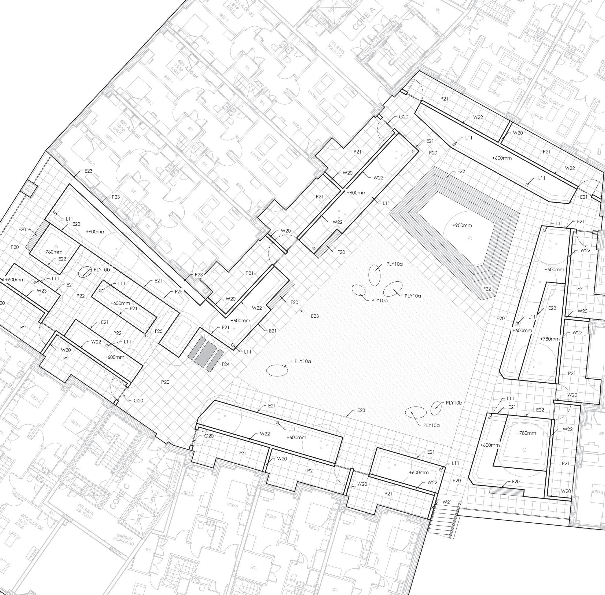
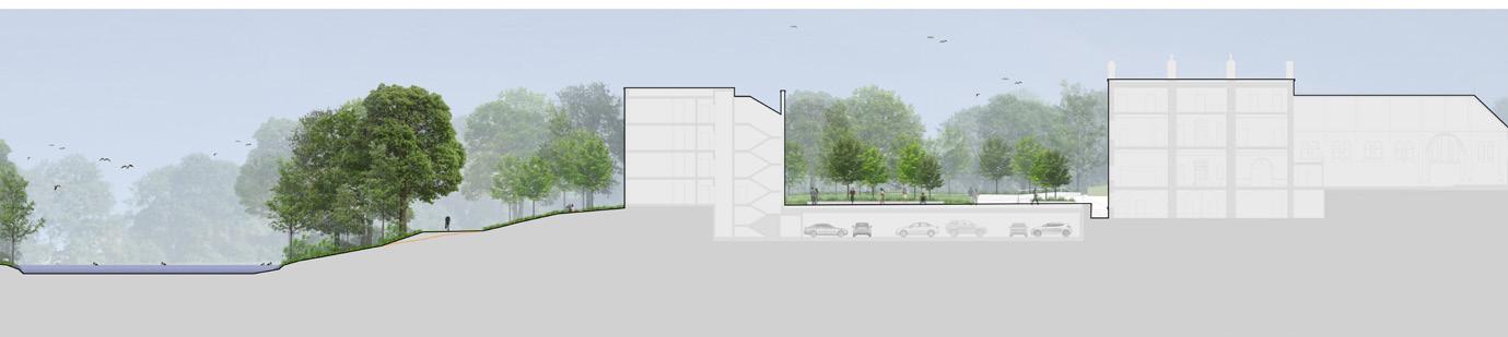
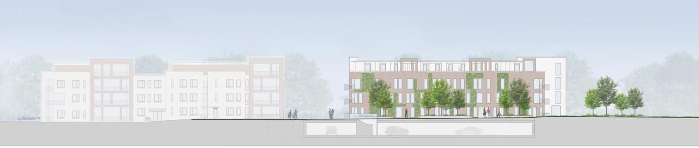
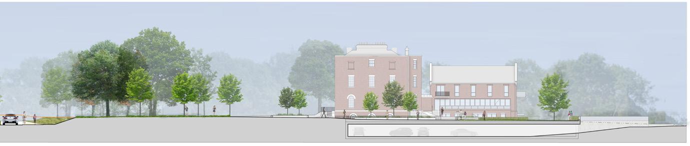
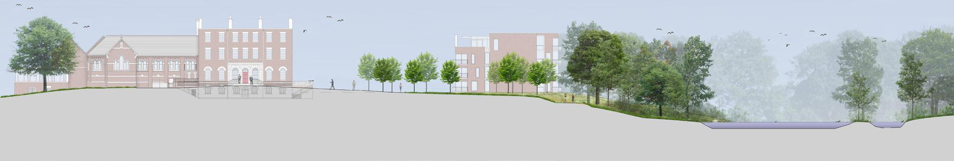
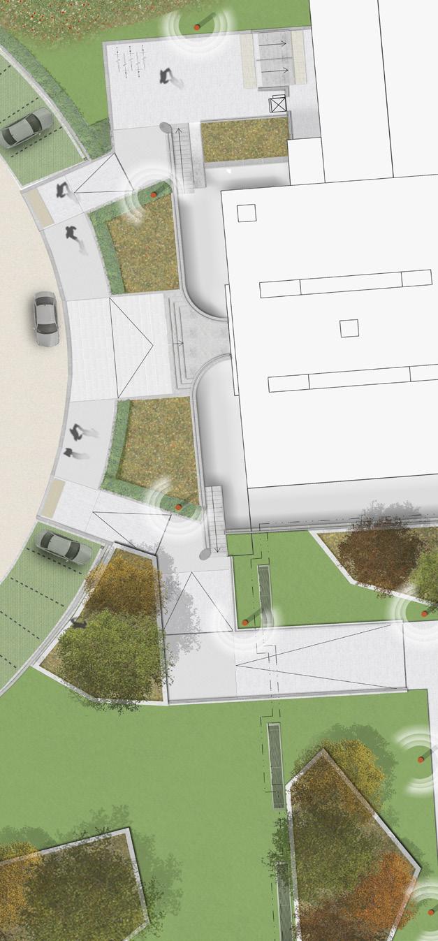
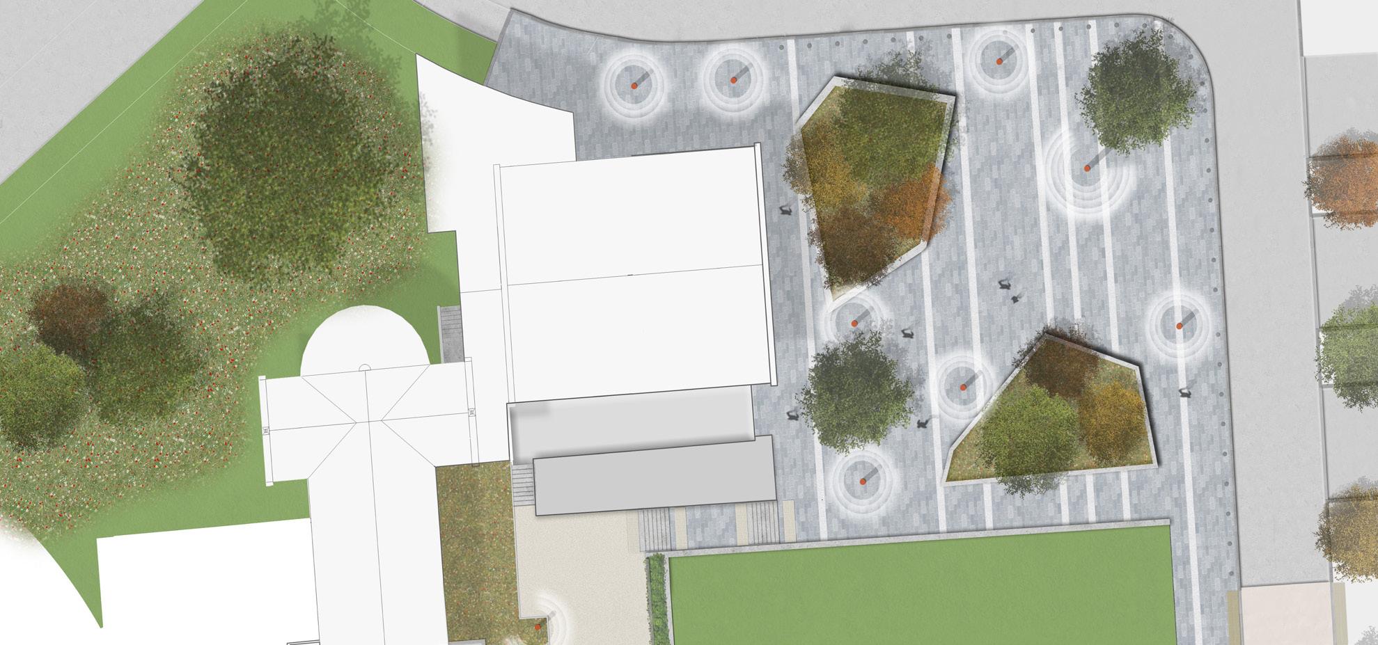
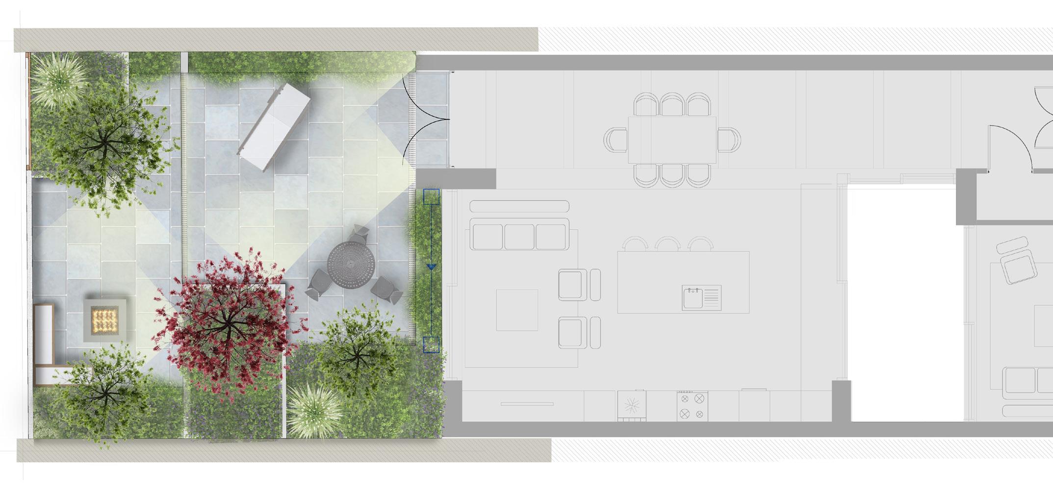
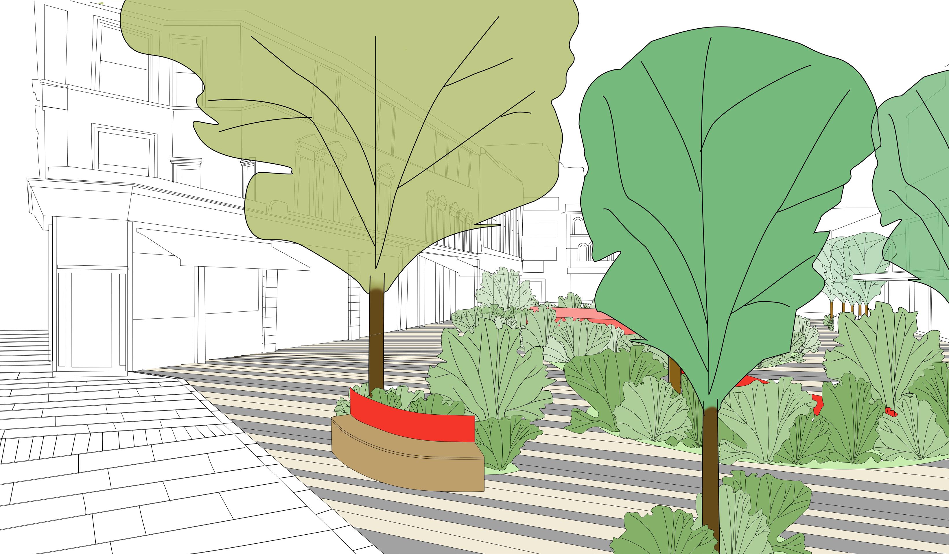
The development comprises a mixed use development for a new NHS Health and Wellbeing Centre, 184 residential flats, workspace and the refurbishment of the Oast House to provide community / arts /workspace
The landscape design for the Oast House site aims to provide a balance between the functional paved areas required for the operation of the development and the desire to maximise the quantum of planting to create a rich and varied place to live and the opportunity to have contact with nature.

The design also acknowledges that public access is encouraged through the site between Kingston Road and Station Path. The principal route is through Oast House Square, although an alternative, more discreet route is possible through the residential garden. It is the intention that this remains open to the public.
The strategy is to cluster the parking and the below ground refuse storage to limit the areas required for vehicle access and turning. Beyond these, are pedestrian only gardens, public square and planted courtyards. Oast House Square is conceived as a flexible paved place, subtly divided with paving and planting into different outdoor rooms.


 View of the Cultural Yard
View of the NHS
View of the NHS Section through NHS
Section through Cultural Yard
View of the Cultural Yard
View of the Cultural Yard
View of the NHS
View of the NHS Section through NHS
Section through Cultural Yard
Gmv
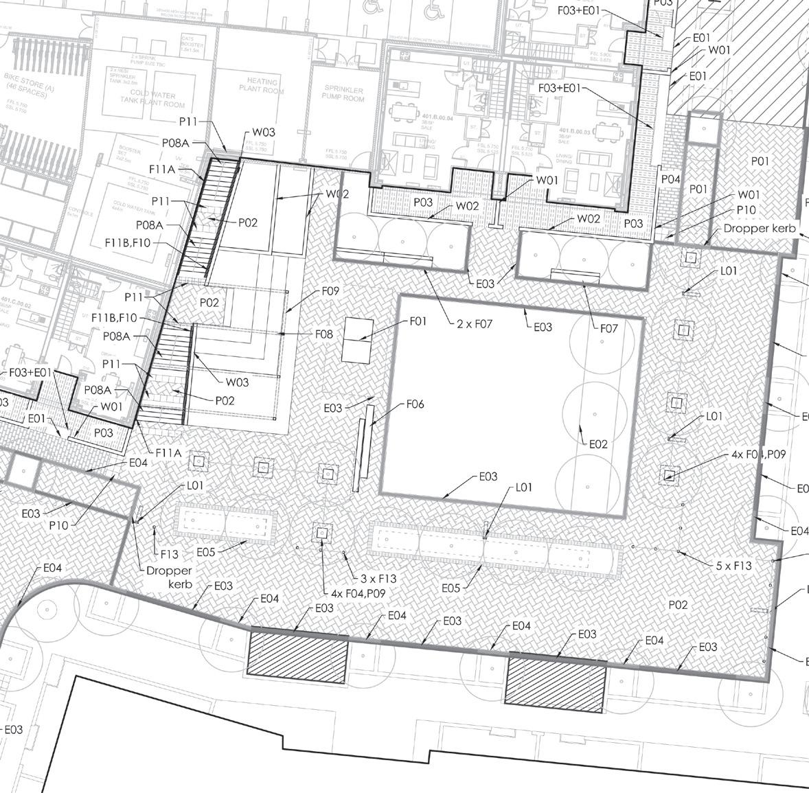
NeiGHbOurHOOd desiGN fOr resideNtial
Studio: Turkington Martin
Site: London (UK)
Program: Public Square and First floor podium
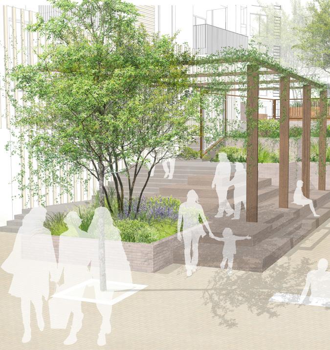
The landscape and public realm proposals are based upon the principles established within the specific context and the building typologies of this new component of the village. Effectively create a new neighbourhood which though clearly part of the GMV family, has a distinct character.
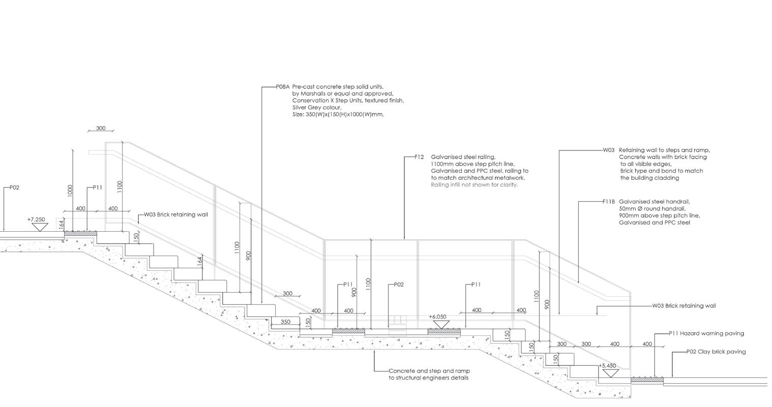
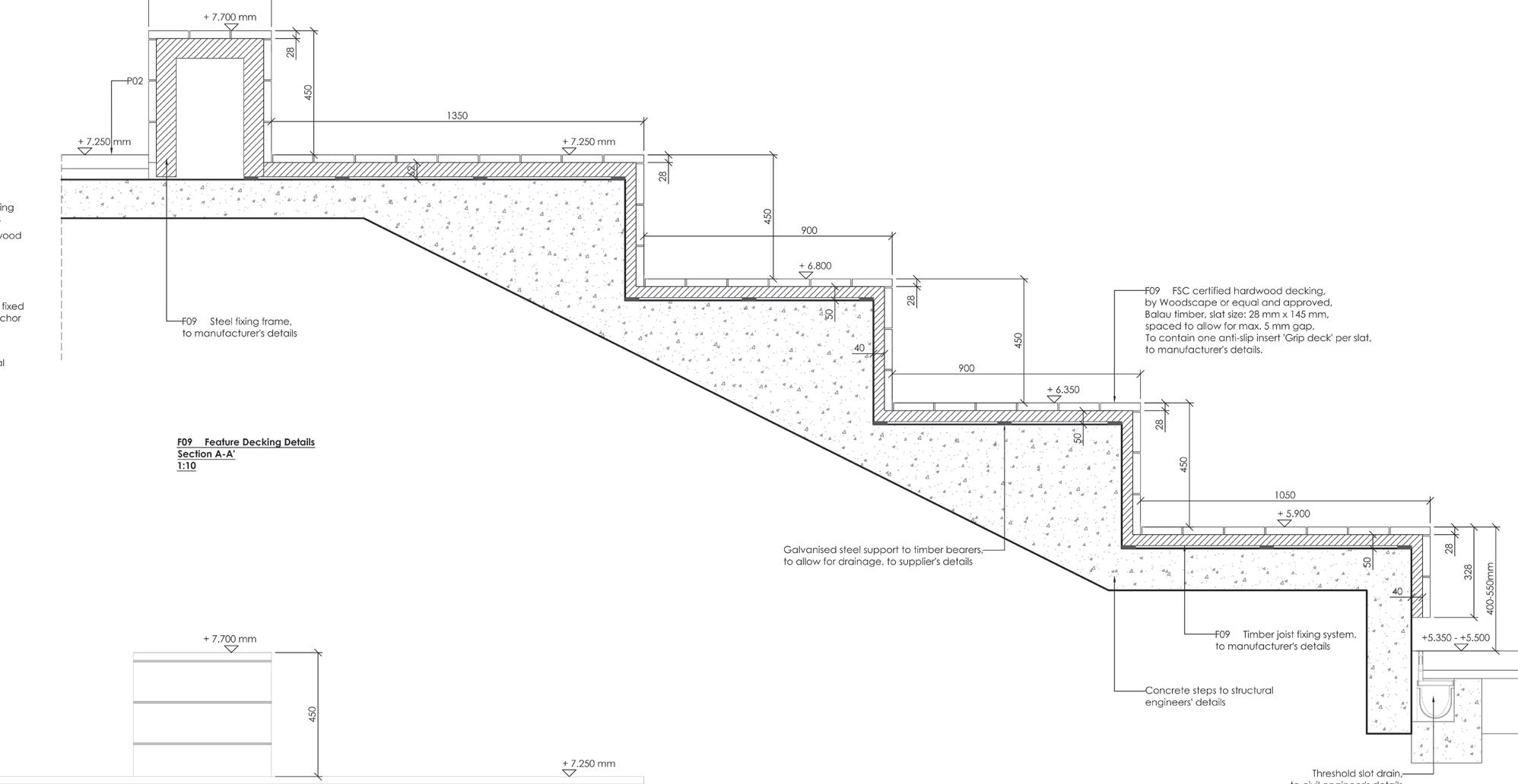
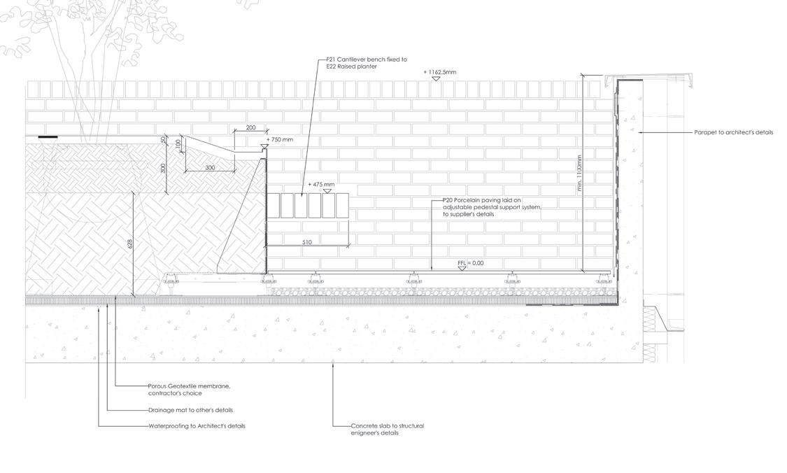
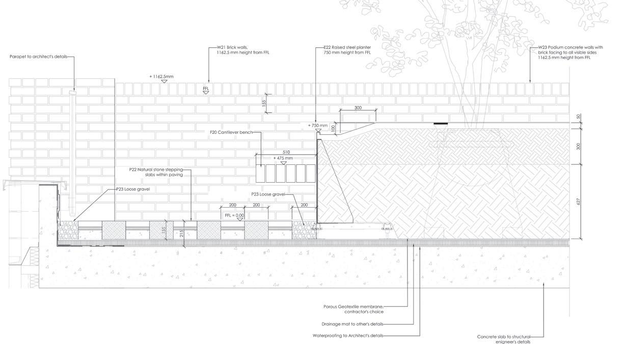
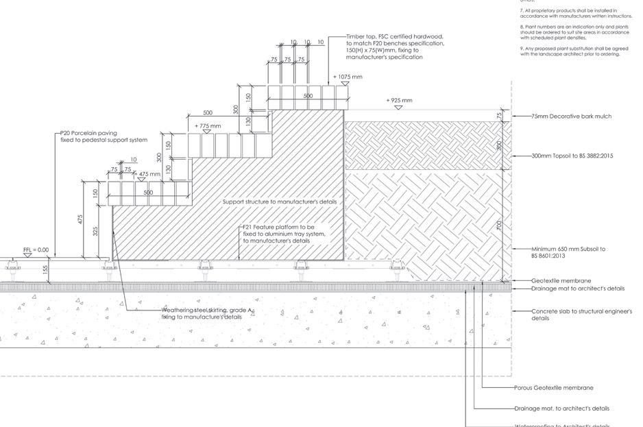
I’ve started working on this project directly on construction detail for Final stage. Here some example of the detail I worked on.
 A previous version of GF-FIRST FLOOR link
latHam COurt rOad
Studio: Turkington Martin
Site: London (UK)
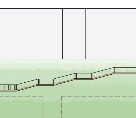
Program: Comunal Garden and Playground
The project located in London is an existing residential development. The existing space was poorly maintained, and the idea is to give back a new playground area and a community space for the tenants. After a different consultation panel with the residents, we land upon the favourite type of play equipment.

In this project, I’ve worked with my senior to understand the space requirements of the falling zone and work out the construction details sets for tender. These are some graphics examples of pictures produce for the panel consultation.

F1 F1 PY02 Existing planter to be cleaned and made good Existing planter to be cleaned and made good +7.29 +7.36 +6.74 To tie into existing levels into existing levels +7.31 +7.30 A-A LS301 B-B LS301 C-C LS301 D-D LS301 D-D LS302 N Key Plan 1:200 01 F1 Existing planter to be cleaned and made good +6.22 +7.29 +6.60 +6.42 To tie into existing levels F4 2m Top Counter E3 F5 F1a +6.855 +7.31 D-D LS302 1/26 F2 PY04 F3 F3 F2 PY01 +6.88 +7.17 D-D LS302 Long Section Part 1:50 Key Plan 1:200 01 D-D LS302 Long Section Part II 1:50 Note: All play equipment to be installed with steel feet as per spec and materials GA
merstHam reC
refurbisHmeNt fOr a urbaN park
Job: Turkington Martin
Site: London (UK)
Project: Playground and Park improvement

Concept: Public Garden
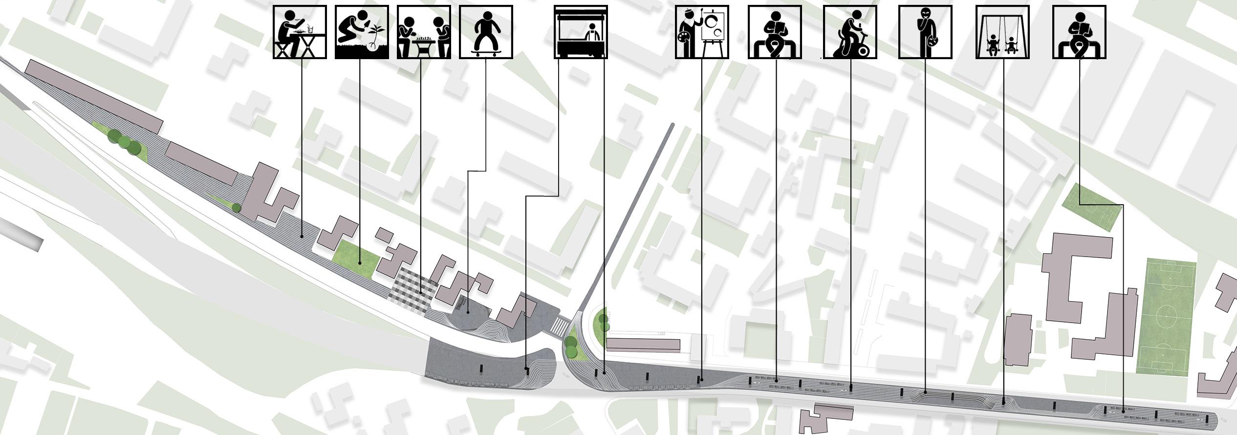
Reigate & Banstead Borough Councillors have approved the funding to project and design proposals for Merstham Recreation Ground Refurbishment. The emerging design has been informed by the feedback gathered since September 2020, from the community through a number of routes, such as surveys and discussion groups.
The main facilities are placed all together in a central location to be convenient to users and to keep a large space for sports pitches. The proposals include a new play area, youth space, parkour course ,outdoor gym, picnic areanand community orchard. This helps define the Recreation Ground as a central ‘green heart’ in Merstham.


Ambitions for the new play area are:


• Accessible for all - achieve ‘Plan Inclusive Play Areas’ gold accreditation
• Delivering fun, challenging play, to allow all stages of development and to be able to enjoy the space together
• Use of natural elements and formal equipment
• Sensory play opportunities: use of colour, texture, sound, smell
• Robust and easy to maintain.
Playground design development
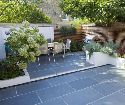
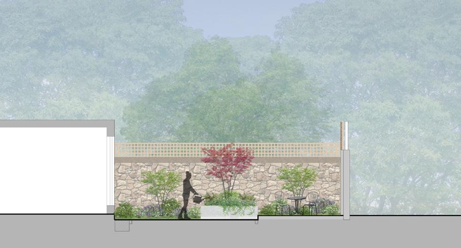
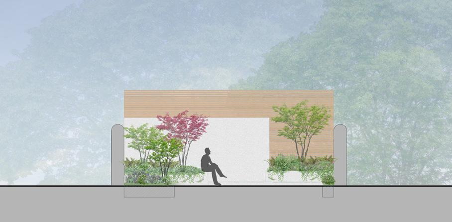
WOOlbediNG GardeN
detail desiGN fOr a GardeN
Studio: MRG + Heatherwick
Site: London (UK)
Program: Public Garden

Together with Heatherwick Studio and The Woolbeding Charity, we have designed a garden that evokes a diverse range of natural environments found along the historical Silk Road.
The aim is to create an immersive experience of these different habitats, not simply by planting the same plants in the gardens, but by interpreting the environments that have been used as inspirational references through the design of new topographies , plateaus and rock formations.
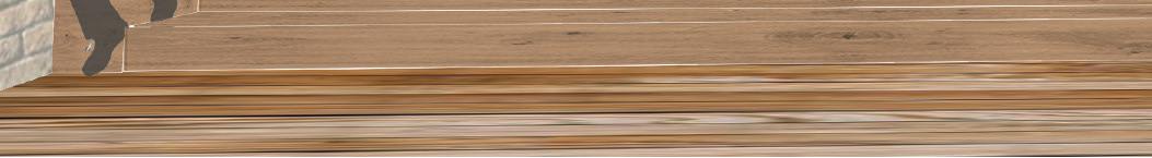
Specifically, I’ve worked on the hardscape design and detail from RIBA Work Stage 3 to Stage 5. S These included the Ha-ha wall design and elevation, the footpath along the public garden and slate path in the Heatherwick designed glasshouse. Construction has just started on site.


COmmerCial aNd resideNtial laNdsCape

spatial layOut aNd paviNG fOr a mixed use aNd a resideNtial COurtyard


Studio: MRG
Site: Dublin (IE)
Program: Mixed-use area
I contributed to the design of the paving and the rendered plan. This space is made of two distinct areas, connected by a small passageway. These spaces are designed for two different purposes: one is a connection between an existing office building and a new building. The other is a residential courtyard adjacent to the new building. The paving strategy creates modules from three different sizes of standard setts in five natural stone colours. Together, these create a geometrical and varying pattern with larger units of colour along the new building which gradually become smaller units towards the existing building. Even during concept design, these modules were studied and tested precisely in AutoCad and Photoshop.

Modules size concept
Manual

Paving concept layout Paving DWG layout
Paving Render layout
Containerisation 1980s
Containerisation present day
east OxfOrd street
desiGN spaCes fOr
a rOOftOp GardeN

Studio: MRG + AHMM Architects
Site: London (UK)
Program: Rooftop garden for office building


The project is a rooftop garden designed as a refuge from the noise and congestion of East Oxford Street. The garden concept design is based around the discoveries of naturalist and botanist Joseph Banks, who used to live in Soho Square Gardens.
The upper terrace on Level 8 will feel open, offering visitors a bigger sense of the sky and city views.
Dark materials have been proposed in Level 8 to evoke the dark sand beach landscapes.
The lower garden on Level 7 will feel more closed and intimate with smaller seating areas located in the main viewing point.
A lighter material can be used in Level 7 to create contrast between the two levels.


Also, as this floor is more densely planted, a lighter material will help to brighten up the space.
Flexible space
Viewing “ Balcony”
Primary circulation
Threshold Secondary circulation
Seating
 Level 8
Level 7
Level 8
Level 7
COmiNGGap
Site: Piacenza (Italy)
Project: Urban Revedelopment
Concept: Market sqaure MAIN STRATEGY
The project site is located in Piacenza, Italy. The concept idea is to develop a connection between the rural outskirt of the city “two disconnected landscapes”, specifically located in the north and south. This idea is achieved through the use of the nodes and empty spaces located in the urban grip, thus that the voids do not divide the void links! Specifically, I’ve dealt with developing the first node located between the agricultural field and the city, in the south area. In the space is located a big supermarket, the idea is to use a big square as a dedicated market space, but the entrance of this space is designed as an urban backdrop, thus to create an ideal the connection between the historical city and the fields


OC INTERNATIONAL SUMMER SCHOOL PIACENZA
Two disconnect landscape


park market parking framework
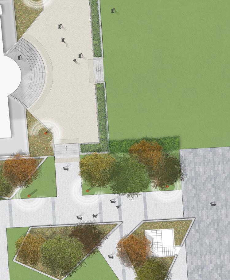
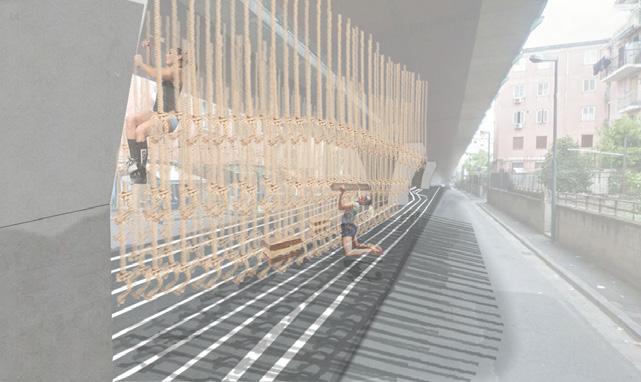
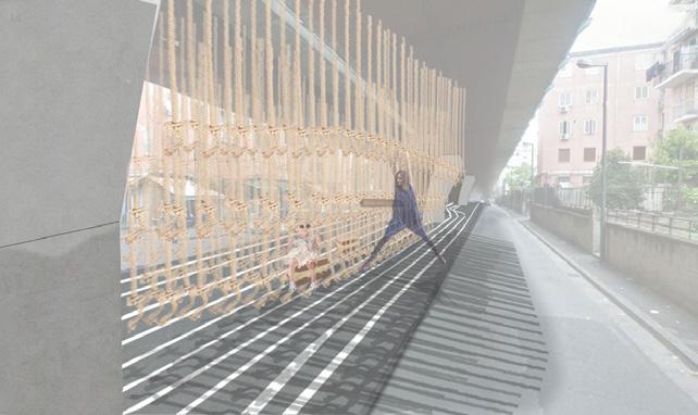
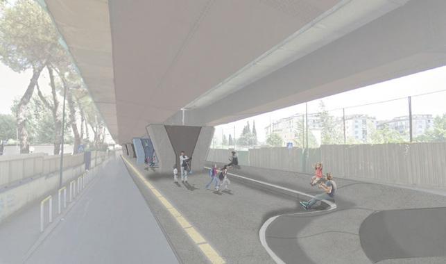
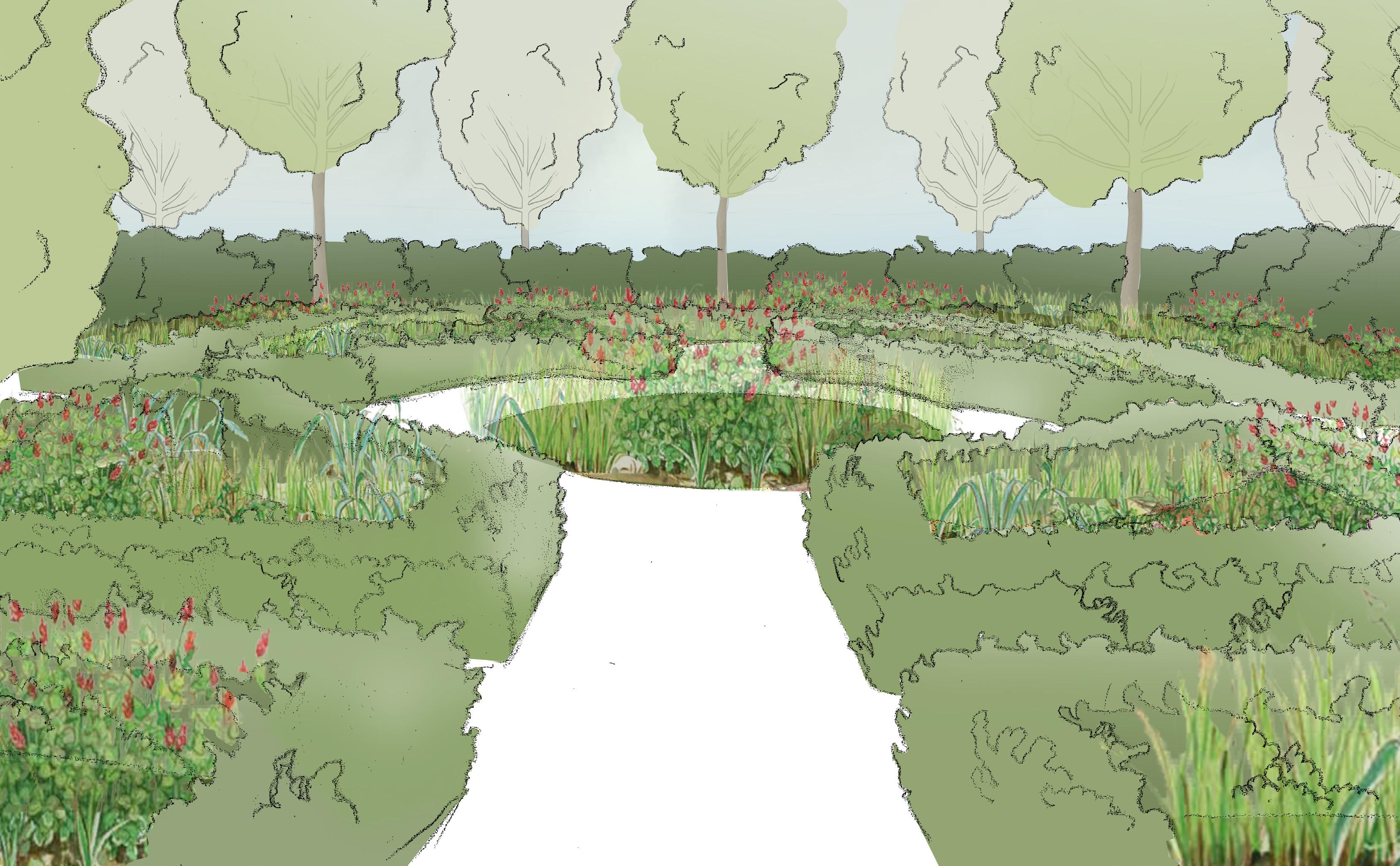
belCamp laNd:
urbaN square fOr a resideNtial area


Job: TBS
Site: Dublin (IE)
Project: Urban square
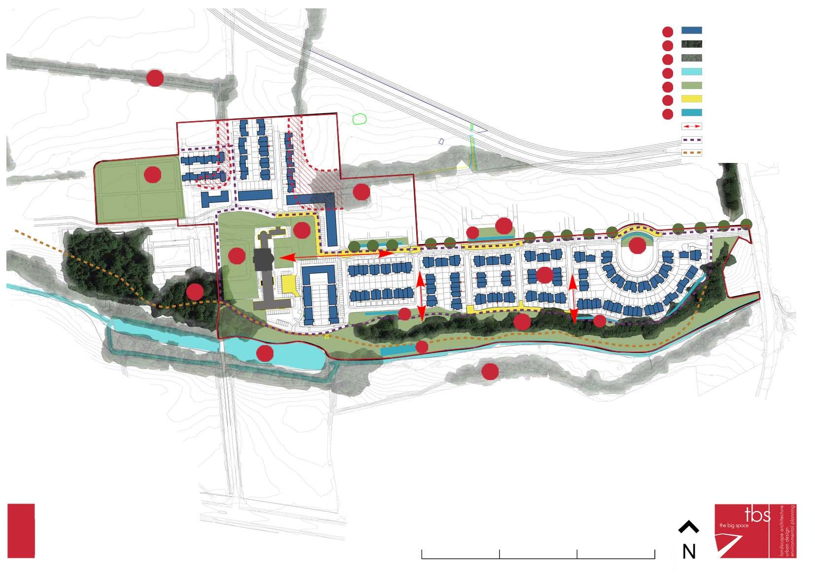
Concept: Mixed-use Area
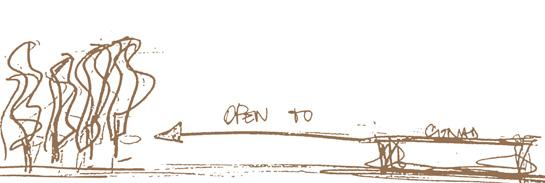
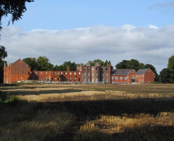
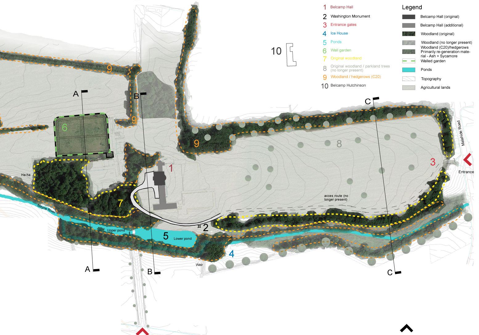
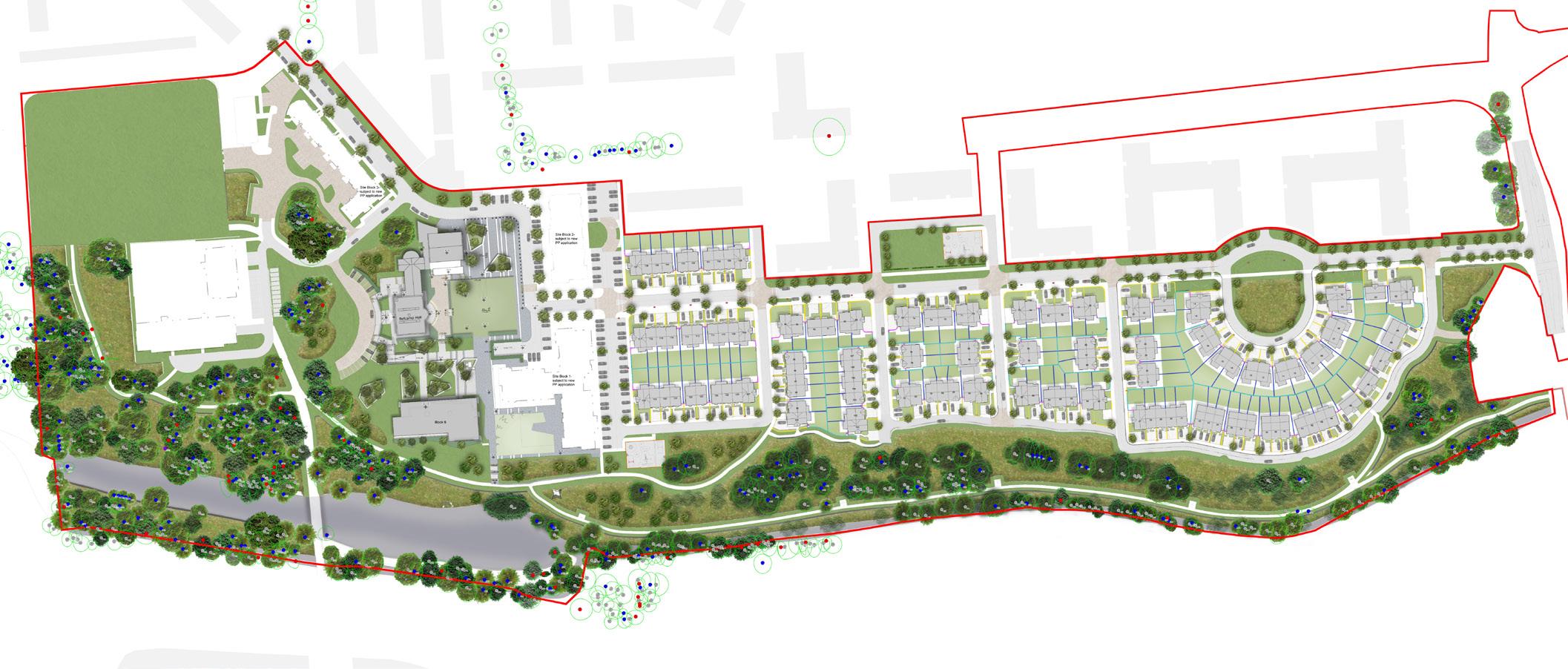
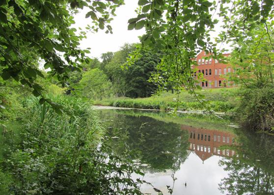
The subject site (Belcamp lands) is located off the Malahide Road, near Dublin City Centre. The site comprises an existing house (with associated additions) and walled garden accessed by an internal access road. Much of the site is relatively level. However, the lands to the south of Belcamp Hall is divided by the Mayne River, the course of which forms a substantial change in level between the main site and the adjoining lands and contains significant woodland.The main aims within the valley area include: Provide public access along the river valley and provide greater ‘visual’ connection to the ponds.
600x200 Limestone paving flags
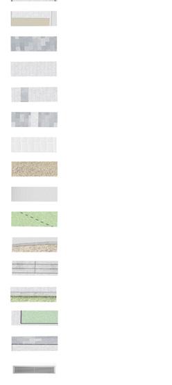
600x200 Granite paving flags
600x400 Limestone paving flags

600x400 Granite paving flags
Tactile paving Granite slab matching the existing
Bound gravel
200x100 Grnaite Setts
Reinforced grass surface
TerraKerb silver granite
Granite steps
Insitu concrete walls or similar

Galvanised metal edging
Slot drainage channel
Basement vent
Lighting locations
Proposed shrubs
Proposed hedge
Outline of basement carpark
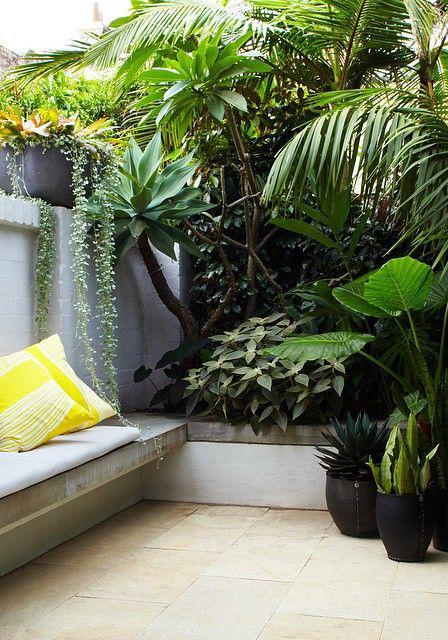
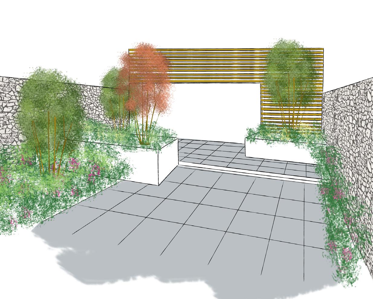
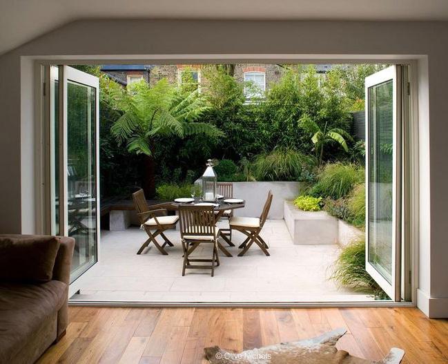
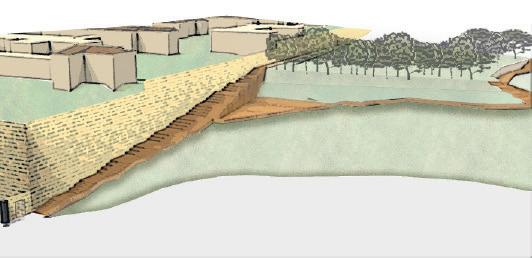
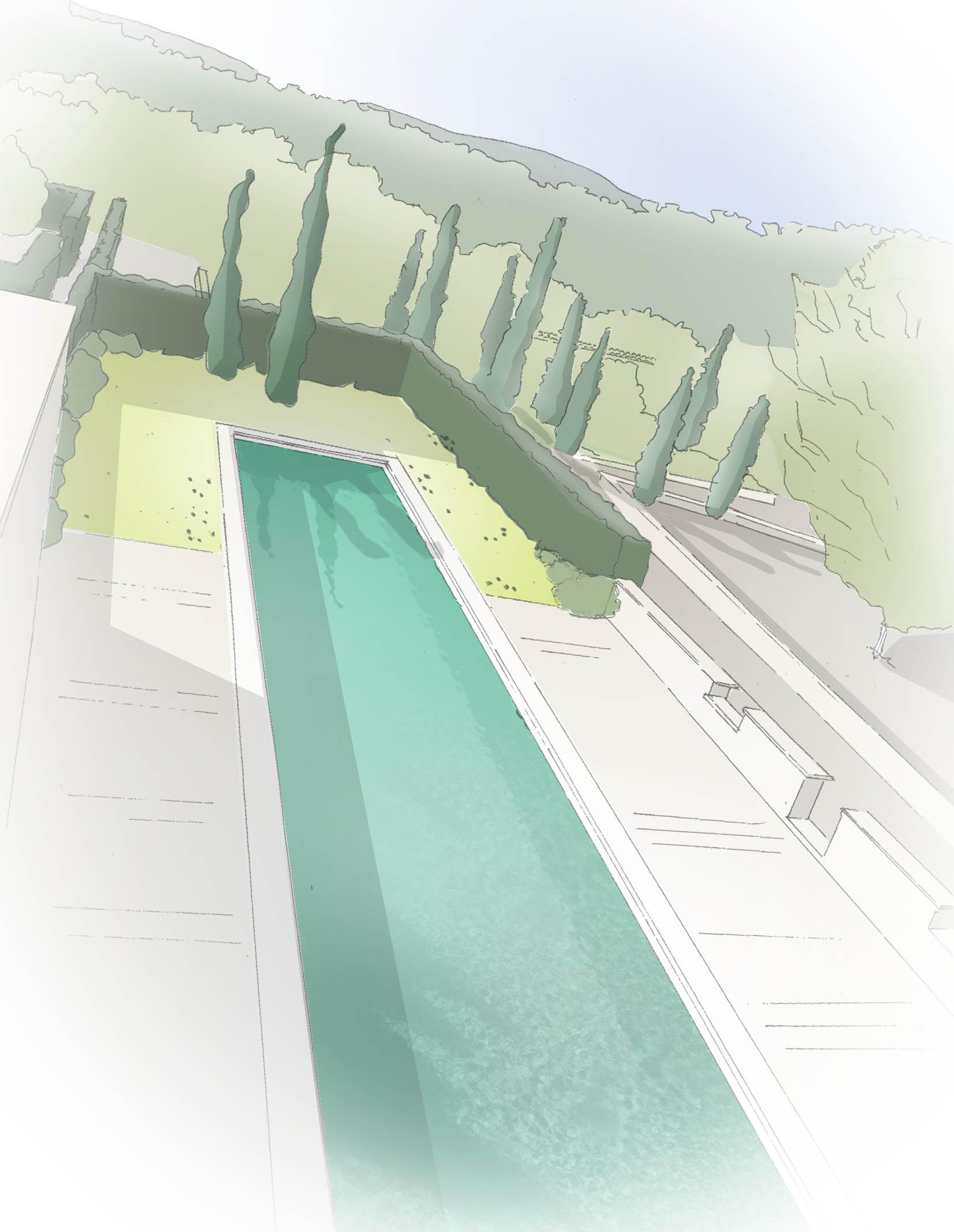
pembrOke laNe: private GardeN desiGN
Job: TBS
Site: Dublin (IE)
Project: Landscape Desing
Concept: Private Garden
This site is located in a newly renovated house. The idea is to create a multi-purpose space thus the resident can make a better use of their private rear garden. Because of the small size of the garden, different layers have been used to create different spaces, by enclosing the view through the use of plating
tHe spaCe Of tHe ObjeCts: prOpOsal Of a

Site: Scampia,NA (Italy)
Project: Urban Park
Concept: Mixed-use Area
The Project is located in Naples in the neglected quarter of Scampia.
As shown by the analysis this place thanks to the undergroung station is well connect to the city center, however the station is never been completed entirely.


We can see how this quarter is completly sorrunded by hight velocity speed, this indicates a poorly connetion to the sourrander quarter, that it creates isolation.
From the analysis we can say that there are a great number of young people and it has one of the bigger green area in Naples.
In Scampia is placed the foumous builgings complex “Le Vele” which even if they are negleted buildings, they are the symbol of this area!
The poject aim is to create a pedestrian connetion with the surrounding through the creation of a linear park which allows different use thanks to its structure, that can change depending on the required purpose.
tO
NOde P l anning Context Land use Shops Medical Church Police School City hall Youth Center Roma Camp Metro Highways Fast lane Main roads Secondary Roads Railway track Main bus station Train depot Metro Stop Gr eenery Analysis Privat Residuals Urban Park Sport Area Agricultura Fields Opportunity Node Constrain Neglect Buildings No access Stop Fast lane Pedestrian Connection Vehicle Connection Landmark Landmark Reference Point Service Pedestrian Connections Via M no Opportunityand constrain
liNear park
tHe pisCiNOla-sCampia
Morning Afternoon


Same spaces different activities


concept of folding ground concept of flows to define spAces concept of grouping the rooMs progrAMMAtic indeterMinAcy


Small pavers for grass Hard pavers for walking Medium size pavers Seating Larger stepped planters Larger planters for tree Playing Talking Looking Climbing Playgrounds (Aldo VanEyck) Taiping Bridge Materials decontextualization Superkilen Affordance “children has to move not the object” Sport Relax Play Renovation 2009 2005 1900 1700 Quing Dynasty 1950
(refereNCe)
Site: Naples (Italy)
Project: Urban Connection
Concept: Pedestrian way
The project site is located near the airport of Naples and besides to the former asylum Leonardo Bianchi. The analysis shows the relationship between the outside walls of the hospital and the surrounding. The hospital has two main sides: the front one, In Calta Capodichino, and the back one in Via F.M. Briganti.


The massive wall and the big scale of the Mental Hospital isolate the building from the outside.
Drop Main road
Secondary road
Connetion Path
Connect ion Point
urbaN CONNeCtiON (leONardO
i) 1 2 1 2
biaNCHi vOl
V i a F.M.Brig a n t i
Former Asylums Leonardo Bianchi CalataCapodichino
The concept idea is to create a connection system that starts from the Giovanni Bosco Hospital and ends up in the disuse Asylum.


This idea con be achieve by usign the existing drop to create a peculiar stair case that follow the ideal contour line of it. Futhermore desinging a raised platform located at main entrance after the hospital exiting ramps, thus to create an ascension through the climbing up of the hospital ramps.


 Ospedale Giovanni Bosco
This stair has a concept the idea to lead on the wall of the Mental Hospital, thus to work together, therefore the hospital doesn’t anymore represent as place of fear, but a place where you can rest thanks to the big steps desgined to create sitting areas.


Site: Naples (Italy)
Project: auto-contruction

Concept: Multi-purpose Pavilion
The project site is located in the back of the former asylum Leonardo Bianchi.
The auto/contrusction pavilion is an allegory of how the patients were disposed inside the hospital, therefore is a journey from the quite patiens untill the more troubled once. The aim is to reverse the direction of the big and monumental block of the former hospital, thus not to have just a

paviliON(leONardO biaNCHi vOl ii) concept of Module coMposition concept of Allegory


bakeri City: masterplaN Of develOpmeNt zONe
Site: Ahmedabat (India)
Project: Urban Planning
Concept: Residential Area
The site is located in Ahmedabat, in India. In This map we can see the opportunity and constrain. There is a wall that surrounds the boundaries of the site, that can be use for a division from the rest, because in India most of the residential communities have a personal gate access. Take into consideration when planning the residential project that the unit should be protected from south exposure, because having a house with a south exposure in India means that the house becomes uninhabitable. One of the constrain that we front is the Indian developing law that impose us to plan the distance between the building as the half of the total height.
Police complex Crematorium New commercial node NewClubhouse NewTemple Primary School Market Area MakarbaRd Shrinand Nagar Rd B a ghE -Ni s hat So c i et y Rd 100FeetRd Recently developed Neglected Activity


The masterplan shows there are four main entrances to this area, all connected to the local roads. The four main accesses are for cars, pedestrians and bicycles. The south area has a different configuration from the north one, the buildings are all the same, for better integration with its surrounding. In the north area we can find the medium and high density buildings, the geometric shape that help to repair from the sun. The tallest buildings are on the back to the area for a more interesting landscape, thanks to the use of lower density in the south area therefore to create a gradual visual grown. The green area in the south is semiprivate, just for a group of buildings. About the green space in the north area it is public, so no fences, but for a proximity it is assumed that it will be used by the buildings surrounding it. Most important of all about the green space is the use of the green corridors, the major once are used to made connection between the sport field and the club house, since their activities are compatible. Increase of the height, that represent an important node.


SKETCHES
alesbaldo@hotmail.com
Alessandra Baldo
