To promote the public health, safety, convenience, comfort, prosperity, and general welfare.
General Provisions
1101: General Provisions
1101.01 TITLE
Title One of Part Eleven of the Plain City, Ohio, municipal code is hereby established and referred to as the Subdivision Regulations.
1101.02 EFFECTIVE DATE
These Subdivision Regulations shall be in force on the earliest date allowed by law.
1101.03 AUTHORITY
These Subdivision Regulations are adopted pursuant to the authority contained in the Ohio Revised Code, Chapters 711 and 713.
1101.04 PURPOSE
These Subdivision Regulations are to guide and facilitate the orderly, beneficial growth of the community by assuring the orderly subdivision of land and its development, and to promote the public health, safety, convenience, comfort, prosperity, and general welfare.
1101.05 JURISDICTION
These Subdivision Regulations shall be applicable throughout the Municipality.
1101.06 REPEAL OF PRIOR ZONING ORDINANCE
These Subdivision Regulations are adopted in whole. These Subdivision Regulations replace any prior Subdivision Regulations or Subdivision Ordinance.
1101.07 CONFLICTING PROVISIONS
Where conflicts exist between requirements of these Subdivision Regulations and other ordinances adopted by Council, the strictest interpretation as interpreted by the Zoning Administrator shall apply and thereby supersede the less strict requirements.
1101.08 SEVERABILITY
If any section, subsection, sentence, clause or phrase of these Subdivision Regulations is held to be invalid, such invalidity shall not affect the validity of the remaining portions of these Subdivision Regulations.
1101.09 INTERPRETATION OF TERMS
All interpretation of terms and phrases in this title follow the rules for interpretation and definitions as found in Title Three, the Zoning Ordinance.
1101.10 WAIVERS
The Planning and Zoning Commission and Council, where they find that extraordinary and unnecessary hardship may result from strict compliance with these regulations as a result of topographic or other physical conditions, may waive such requirements provided that such a waiver does not violate the intent of these regulations and will not be detrimental to the public interest and also reflects the spirit of the comprehensive plan. Under no circumstances shall waiver be granted under this section to any requirements of the Zoning Ordinance.
1101.11 TESTING
Testing to ensure compliance with the standards contained herein shall be required by the Engineer and shall be at the expense of the subdivider.
1101.12 VIOLATIONS AND PENALTIES
Any person, firm, or corporation who fails to comply with, or violates, any of these Subdivision Regulations or Chapter 711 of the Ohio Revised Code shall be subject to the penalties as set forth in said Chapter 711.
The Zoning Administrator shall serve a written notice or order upon the person responsible whenever the Zoning Administrator determines that any work is being done or any transactions are being made in violation of the provisions of these Subdivision Regulations. Such notice shall direct the discontinuance of any illegal action and the remedying of the condition that is in violation. In case such notice or order is not promptly complied with, the Zoning Administrator may stop all services to the property where such violation is concerned and to refuse such services until the violation is corrected. The Zoning Administrator may also request the Solicitor to institute the appropriate action or proceeding at law or equity to restrain, correct, remove or prosecute such violation.
1101.13 APPEALS
Any person, firm, or corporation who believes they have been aggrieved by these regulations has all the rights of appeal as set forth in Chapter 711 of the Ohio Revised Code.
Subdivision Approval Processes
Chapter 1103
1103: Subdivision Approval Processes
1103.01 PURPOSE
This chapter is intended to outline the process by which a parcel of land is subdivided.
1103.02
PLATTING REQUIRED
(a) No land shall be subdivided until:
(1) The subdivider submits plats as described in these Subdivision Regulations;
(2) Said plats have been approved as provided herein; and
(3) The approved plats are recorded in the County Record of Plats.
(b) No Zoning Permit shall be issued for any parcel or plat of land which was created by subdivision after the effective date of, and not in conformity with, the provisions of these Subdivision Regulations, and no excavation of land or construction of any public or private improvements shall take place or be commenced except in conformity with these regulations and other applicable local codes.
1103.03 APPLICATION
REQUIRED
Application for subdivision must be submitted to the Zoning Administrator. The following procedure shall be followed with regard to the submittal, review, and approval of subdivision plats.
1103.04
STEP 1: PRE-APPLICATION CONFERENCE
(a) Prior to submission of a preliminary plat, the applicant shall submit a Concept Plan to the Zoning Administrator for review.
(b) After the Concept Plan and any other plans and data are submitted, the Zoning Administrator shall arrange and conduct a joint meeting with the Engineer, planning staff, and the applicant to review the documents and to familiarize the applicant with the Planning and Zoning Commission’s requirements, the comprehensive plan, the thoroughfare plan, the parks and open space plan, the Zoning Ordinance, and the Municipality’s drainage, sewerage, and water systems.
1103.05
STEP 2: SUBMITTAL OF PRELIMINARY PLATS
(a) The applicant shall submit a preliminary plat, together with supplementary materials and required fees, to the Zoning Administrator no fewer than 30 calendar days prior to the Planning and Zoning Commission meeting at which it is to be considered. Whether the proposed subdivision is proposed to develop the tract in one phase or in sections or stages, layout of the entire tract is required.
(b) The Zoning Administrator shall review submitted materials for completeness. The Zoning Administrator’s determination of completeness shall be presented in writing to the Planning and Zoning Commission and the applicant.
(c) The application shall be considered filed as of the date the application and the filing fee are received by the Zoning Administrator.
(d) At a public Planning and Zoning Commission hearing, the Planning and Zoning Commission shall review said preliminary plat and shall:
(1) Approve the preliminary plat as submitted or modified;
(2) Conditionally approve the plat and stipulate the conditions of such approval; or
(3) Disapprove the preliminary plat and express the reasons therefore.
(e) The action of the Planning and Zoning Commission shall be noted on two copies of the preliminary plat. One copy shall be returned to the applicant within 15 calendar days of the Planning and Zoning Commission’s decision, and the other shall be filed by the Zoning Administrator.
(f) Approval of a preliminary plat shall not constitute approval of the final plat and improvement plans, but rather shall be deemed an expression of approval of the layout as a guide to preparation of the final plat.
(g) Components of a Preliminary Plat. A preliminary plat must include the following elements:
(1) All dimensions necessary for locating boundaries of the land to be subdivided, including lots, streets, alleys, easements and building line setbacks, and any other similar public or private areas;
(2) The current zoning district or districts of the land to be subdivided and of the contiguous properties;
(3) The acreage of the land to be subdivided;
(4) The location, dimensions, area (in square feet), and numbering of all proposed lots. When lots are located on a curve or when side lot lines are at angles other than 90 degrees, the width of the lot at the building line shall be shown;
(5) The location, dimensions, and area of all land proposed to be set aside for parks, open space, other public or private reservation, with designation of the purpose and proposed ownership thereof;
(6) The location, width, names, and classification of all existing and proposed streets, rights of-way, and easements, and, where pertinent, their designated use within 500 feet of the proposed subdivision. Streets that are obviously in alignment with others already existing and named shall bear the names of the existing streets. New street names shall not duplicate names of existing streets in Madison or Union Counties and are subject to approval by the Planning and Zoning Commission;
(7) The location of existing and proposed water bodies, wells, streams, drainage ditches, stands of trees and trees of more than 6 inches in diameter, and other pertinent features within 500 feet of the proposed subdivision;
(8) Delineation of the drainage areas involved, with a plan for draining the total upstream watershed through the development. The major storm routing path shall be delineated;
(9) The 100-year floodplain of any stream identified as having a flood hazard area;
(10) Location and illustration of existing storm and sanitary sewers, culverts, drainage tiles, water lines, gas lines, CATV, utility poles, and utility lines within and adjacent to the proposed subdivision. In addition, the name(s) and service boundaries of the utility provider(s) shall be clearly identified;
(11) Proposed connections to existing water supply and sanitary sewer systems and for the collection and discharge of surface water drainage including the location and size of existing and proposed water mains, sanitary sewers, and drainage facilities; and written indication from the Municipal Administrator that capacity for both water and sanitary sewer service is available;
(12) Soils information derived from the United States Department of Agriculture Soil Survey. The location and results of tests made to ascertain subsurface soil conditions, if required by the Planning and Zoning Commission, shall be shown;
(13) The name and address of the developer, the name and registration number of the registered surveyor, the name and registration number of the registered engineer;
(14) The names and locations of all adjoining property owners and adjacent subdivisions within 150 feet of the proposed subdivision;
(15) Approximate location of all existing buildings within 500 feet of the proposed subdivision;
(16) Existing topography with a maximum contour interval of two feet. The location of bench marks and their elevation and all other monuments shall be shown; and
(17) Where it is proposed to develop the tract in sections or stages, a tentative delineation of the sections and their phasing, including an estimated time frame.
1103.06 STEP 3: SUBMITTAL OF FINAL PLATS
(a) Following the approval of a preliminary plat, the applicant must submit a final plat for approval.
(b) Final plats shall be subsequent to and substantially in conformance with a previously approved preliminary plat.
(c) The final plat, required fees, and supporting data shall be submitted to the Zoning Administrator no fewer than 30 calendar days prior to the Planning and Zoning Commission meeting at which it is to be considered.
(d) If final plats are not submitted to the Zoning Administrator within 12 months after the approval of the preliminary plats, such preliminary plat approval shall become null and void unless an extension of time has been granted by the Planning and Zoning Commission upon showing of cause. Only one extension of time may be granted. An extension may not exceed a period of 12 months.
(e) Final plats shall be prepared by a registered surveyor, engineer, architect, or landscape architect.
(f) The Zoning Administrator shall review the submittal for completeness and compliance with the preliminary plat, appropriateness of any modifications, and these Subdivision Regulations. The final plat submission shall be considered complete on the date that the following items have been received by the Zoning Administrator.
(1) A final plat with components as outlined later in this section;
(2) A landscaping plan;
(3) An erosion, sediment, and stormwater control plan as described in the Zoning Ordinance;
(4) A letter from the Municipality’s Administrator and Engineer approving the improvement plans for the water distribution, storm water, and sanitary sewer systems;
(5) Bonds or other guarantees as may be required;
(6) All approvals from other municipal, county, state, Federal, or district regulatory agencies; and
(7) Payment of all required fees.
(g) The Zoning Administrator’s findings of completeness shall be presented in writing to the Planning and Zoning Commission and to the applicant.
(h) Communications with the State Director of Transportation
(1) Before any final plat is approved by the Planning and Zoning Commission, the applicant shall give notice to the State Director of Transportation of the proposed improvements and obtain a letter from the State Director of Transportation stating that:
(i) The property is not within 300 feet of the centerline of a proposed new highway, or within 500 feet of the centerline of a highway for which changes are proposed; or
(ii) The property is within these limits but that acquisition of the land at this time is not in the public interest.
(2) At the request of the applicant, the Planning and Zoning Commission may give conditional approval and allow the applicant to proceed with completion of the plat. However, it shall be clearly at the applicant’s own risk and the conditional approval shall be withdrawn if the State Director of Transportation proceeds to acquire the land.
(3) A copy of correspondence to the State Director shall be mailed to the Zoning Administrator. The correspondence to the State Director shall indicate a 120-calendar day notification deadline.
(4) If the State Director of Transportation notifies the Planning and Zoning Commission that the State shall proceed to acquire the land needed, then the Planning and Zoning Commission may refuse to approve the plat, according to provisions of Section 5511.01 of the Ohio Revised Code.
(5) If the State Director of Transportation notifies the Planning and Zoning Commission that acquisition at this time is not in the public interest, or upon expiration of a 120-calendar day period from date of notice to the State Director or any extension thereof agreed upon by the State Director of Transportation and the property owner, the Planning and Zoning Commission shall, if the plat is in conformance with all provisions of this Subdivision Ordinance, approve the plat.
(i) The Planning and Zoning Commission shall review the final plat and recommend either:
(1) Approval;
(2) Approval with conditions; or
(3) Disapproval.
(j) The final plat, together with a letter signed by the Chair of the Planning and Zoning Commission stating the Planning and Zoning Commission’s recommendation, shall then be immediately forwarded to Council.
(k) The final plat will be heard by Council no more than 30 calendar days after receipt of the final plat as reviewed by the Planning and Zoning Commission.
(l) Council shall either approve or disapprove the plat.
(m) Should Council approve the final plat, the applicant shall deliver to the Municipality’s Finance Director a bond as described in these Subdivision Regulations.
(n) Upon review and approval of said items, the Municipal Administrator shall sign the final plat, and it shall be recorded. The placement of the Municipal Administrator’s signature on the plat shall constitute final approval of the subdivision.
(o) The required bonds shall be posted and the plat placed on record within six months from the date of Council’s approval or the plat shall be null and void, except that said time may be extended by Council for good cause.
(p) If the plat is disapproved by Council, it shall be returned to the Planning and Zoning Commission with recommendations for modification. A two-thirds majority vote is required by Council to overturn a recommendation by the Planning and Zoning Commission.
(q) A hard copy of an approved final plat as recorded shall be submitted to the Zoning Administrator by the applicant. The applicant may then begin constructing the infrastructure improvements. Upon satisfactory completion of the subdivision as determined by the Engineer, “as-built plans” based on the Municipality’s inspection records and prepared by the developer shall be submitted to the Zoning Administrator. Acceptance of the improvements shall occur upon adoption by Council of an ordinance stating such acceptance.
(r) Application for building permits for lots within the subdivision shall not be submitted until after the plat is recorded, all additional engineering fees incurred by the Municipality for review have been paid, and a bond is posted for the estimated construction and inspection cost of the improvements, and other items as required by these Subdivision Regulations.
(s) Components of a Final Plat. A final plat must include a plan drawing, stamped by a registered surveyor, which includes all information required for a preliminary plat, plus the following:
(1) The location of setback lines from all rights-of way, public or private;
(2) The proposed elevation of the top of all street curbs adjacent to each lot, reserve, or other parcel, based on USGS elevation or those as approved by the Engineer;
(3) Radii, arcs, delta, arcs, chords, and points of tangency, central angles for centerlines of all curvilinear streets, and radii for all rounded corners of streets, alleys, curbs, and pedestrian paths;
(4) Stations at every 100 feet on centerline of each street and at the limits of development;
(5) All water mains, their sizes, valves, and fire hydrants, and location of mains to centerline of street;
(6) All storm sewers and appurtenances. Identify storm sewer appurtenances by type. All appurtenances shall be numbered. Indicate the top elevation of each structure. Storm sewer appurtenances and locations should be referenced to the centerline station of street;
(7) All sanitary sewers and appurtenances. Identify sanitary sewer appurtenances by type. All appurtenances shall be numbered;
(8) The location of all or any natural springs whether within or draining to street right-of-way and indicate proposed treatment of same. All springs will be capped and piped in a minimum 6-inch diameter perforated pipe encased in washed gravel, and connected into the nearest storm manhole or curb inlet;
(9) Guard posts or barricades at the end of streets which are to be extended in the future;
(10) Any private restrictions;
(11) A certificate showing that all taxes due have been previously paid and a certificate of title or photocopy thereof;
(12) A certificate by the owner of the land to the effect that he has caused the land to be platted and that he dedicates to public use the streets, parks, and other land indicated on the plat as intended for public use;
(13) A statement signed by the owner setting forth the rights associated with the easements and reserve parcels shown on the plat;
(14) A tabulation showing the exact area of each lot, reserve, or other parcel on the plat, other than streets and alleys, such area to be computed inclusive of and after the extensions of lot or parcel lines to the centerline of contiguous public ways, such as streets or alleys. The purpose of this requirement is to facilitate calculation of the trunk sanitary sewer benefit charges for each lot and parcel;
(15) Certification by a registered surveyor that the information contained on the plat is true and correct and conforms to the requirements of these Subdivision Regulations;
(16) An approval block for the endorsement of the plat upon the approval by Council; and
(17) Notes that may be necessary to explain the intent and purposes of the plan.
A final plat must also include a profile view that includes the following:
(1) Elevations at beginning and end of all vertical curves;
(2) Length of vertical curves with elevations and stations of vertical points of intersections (VPI);
(3) Elevations computed every 50 feet on all tangent sections, and grades computed every 25 feet in all vertical curves;
(4) Extension of centerline profile 300 feet beyond property line or boundary on all streets that provide for access to adjoining property;
(5) Existing centerline profiles for 200 feet minimum distance to ensure proper grade tie, when proposed street is an extension of, or connects with, an existing street or road; and
(6) Centerline profile of existing street or road 300 feet minimum distance to right and left of proposed connection when a proposed street intersects with an existing street or road.
1103.07 APPROVAL PERIOD
(a) The approval of the preliminary plat shall be effective for a maximum period of twenty-four (24) months and shall guarantee that the terms under which the approval was granted will not be affected by changes to these regulations, or changes in the Planning and Planning and Zoning Ordinance provided that a final plat is filed within this period.
(b) The approval of the Planning Commission shall be null and void for all undeveloped portions of a development as shown on the preliminary plat:
(1) If a final plat has not been submitted to the Planning Commission for the first phase of development within twenty-four (24) months of the preliminary plat approval or on the schedule as established in the approval of the preliminary plat.
(2) If a final plat has not been submitted to the Planning Commission for the next phase of development within twenty-four (24) months of the approval by the City of a preceding phase of development or on a schedule as established in the approval of the previous final plat, or
(3) The City Planning Commission, upon demonstration in writing of extenuating circumstances may at their discretion grant extensions of the twenty-four (24) month approval period. Granting of such extensions may result in additional bond being required.
(4) If the time limits stated in subsections (b)(1) or (b)(2) hereof have been exceeded and no time extension has been granted per subsection (b)(3) hereof by the Planning Commission.
(5) All phases occurring after the original approval period, as described in this section, shall be in conformance with the current zoning standards in effect at the time of filing.
1103.08 MINOR SUBDIVISIONS
(a) Minor subdivisions may seek approval without plat if the subdivision of the parcel meets the following criteria:
(1) The parcel and proposed new lots are situated along an existing street right-of-way
(2) The parcel’s subdivision does not involve the opening, widening, or extension of any street, road, or access point; and
(3) The subdivision involves an existing tract of land from which no more than five lots can and will be created that meet the current lot requirements for the zoning district in which they are located.
(b) If the Zoning Administrator is satisfied that such proposed subdivision complies with applicable zoning requirements, that the subdivision will not necessarily preclude anticipated future development or redevelopment, and the proposed subdivision does not interfere with the provision of municipal services, the Zoning Administrator, acting on behalf of the Planning and Zoning Commission, shall stamp conveyances for lots within the subdivision “Approved by: Planning and Zoning Commission. No Plat Required.”
(c) The Zoning Administrator, acting on behalf of the Planning and Zoning Commission, may also establish reasonable necessary procedures and requirements to be met by the subdivider. Such necessary procedures and requirements may include requirements for the extension or improvement of public infrastructure to support the subdivision or possible growth or development for the area.
(d) No Zoning Permit shall be issued until all provisions stipulated by the Planning and Zoning Commission have been completed and accepted by the Municipality in accordance with the site development process.
(e) Filing Fee. Each application submitted and processed for a subdivision without plat shall be accompanied by a filing fee.
(f) Appeal. Any person aggrieved by a Planning and Zoning Commission decision under this section shall have the right to appeal said decision to the Council by filing a written appeal within 10 calendar days of receipt of notification of the decision.
1103.09 PLATTED EASEMENTS
The following standards shall govern the provision of easements:
(a) Drainage Easement
(1) Where a subdivision is traversed by a water course, drainage way, channel, storm conduit, stormwater basin, or stream, there shall be provided to the Municipality a stormwater easement or drainage right-of-way conforming substantially with the lines of such water course and containing additional width as required for maintenance.
(b) Utility Easements
(1) Easements, a minimum of 10 feet in width shall be provided adjacent to each side of and contiguous with all proposed rights-of-way. Such easements may be used for any and all public or private underground utilities.
(2) Easements across lots or along side or rear lot lines shall be a minimum 20 feet in width. The Engineer may require additional width where appropriate, based on the proposed usage.
(3) If a proposed utility is outside the right-of-way, a minimum of eight feet of clearance must be provided between the centerline of the proposed utility and the edge of the easement. If a proposed utility is within the right-of-way, an easement must be provided adjacent to the right-of-way if the utility is less than eight feet from the right-of-way line.
(c) Access Easements
(1) Where subdivisions are adjacent to schools, parks, or other public facilities, access easements shall be provided to those facilities where deemed appropriate by the Planning and Zoning Commission.
(2) Such access easement shall be a minimum of 20 feet in width, and side yard setbacks for adjacent lots shall be measured from the easement.
1103.10 BONDING REQUIREMENTS
Three types of bonds are required upon approval of a final subdivision plat: a performance bond, a warranty/ maintenance surety, and a restoration bond.
(a) Performance Bond Required
Upon approval of a final plat by Council, the subdivider shall furnish a performance bond or other acceptable security prior to endorsement of the plat by the Mayor. Said bond shall be in one of the following forms:
(1) The subdivider shall deposit a cash security with a local bank in the amount of 100 percent of the estimated cost of the public improvements (e.g., storm sewers, sanitary sewers, water lines, pavements, sidewalks, bikeways, curb and gutter, drainageways, and landscaping) based on the then current State of Ohio prevailing wage rates. Said security shall be in favor of the Municipality which shall have sole control of the bond’s disbursement. The local bank shall be directed to pay out portions of the cash security towards the completion of said improvements to the subdivider only with the approval of the Municipal Administrator, who may require a balance to be maintained, which in their opinion is sufficient to complete said improvements in accordance with the plans and specifications of the Municipality and who shall authorize the release of any balance to the subdivider only upon acceptance of said improvements by Council.
(2) The Municipal Administrator, Zoning Administrator, and Engineer, in consultation with the subdivider, shall establish a time period for the completion of required improvements. In the event that said improvements are not constructed within the designated time period and not maintained, the Municipality shall have the option, after 30 days’ written notice to the subdivider, to complete and maintain said improvements and to collect and receive from the local bank any remaining balance of said deposit to be applied toward payment of costs and expenses of completing said improvements, or
(3) The subdivider may furnish corporate surety bond in the principal amount of the estimated cost of said improvements to the satisfaction of the Mayor and Council, in such a form approved by the Solicitor, guaranteeing completion and maintenance of said improvements according to plans, profiles, and specifications and to the satisfaction of the Engineer. Said bond shall remain in effect until said improvements have been completed and maintained as provided in these regulations and until released by authority of Council. Said bond shall provide that, upon default of performance by the subdivider, the Municipality may complete the same improvements after 30 days’ written notice.
(b)
Warranty/Maintenance Surety Required
(1) Concurrent with acceptance of the subdivision, the subdivider shall submit a warranty/maintenance surety in an amount of 10 percent of the original cost of the improvements which shall be in force for two years following acceptance of any required improvements and shall guarantee satisfactory performance of the said improvements.
(c) Restoration Bond Required
(1) Upon approval of a final plat by Council, the subdivider shall furnish a restoration bond in addition to the performance bond.
(2) Said restoration bond shall be to insure repair of any damage done to existing curb, gutter, sidewalk, driveways, street pavement, landscaping, drainageway, or other items within the right-of-way adjacent to a subdivision, and damages as a result of a poorly executed erosion, sediment, and stormwater control plan. The amount of said bond shall be as determined by the Municipal Administrator based on their estimate of potential damage. Restoration bonds shall be released when all damaged facilities, if any, have been restored to the satisfaction of the Engineer.
(d) Maintenance and Repair of Public Improvements
(1) The subdivider shall maintain all improvements in the subdivision and provide for snow removal in the same until final acceptance of all improvements is granted.
(2) For a period of two years from the date the constructed improvements are accepted by Council, the subdivider shall make such repairs or replacements as may be required by reason of defective workmanship or material.
(e) Appeal
Where the subdivider is aggrieved by a decision of the Engineer, they may appeal said decision to the Planning and Zoning Commission.
1103.11 INDEMNITY INSURANCE.
(a) A policy of indemnity insurance in the amount of $500,000/$1,000,000 personal liability and $1,000,000 property damage protecting the Municipality against any claims for damage to person or property resulting from or by reason of the construction of the above mentioned improvements shall be furnished to the Municipality’s fiscal officer and maintained in force by the subdivider.
(b) The insurance policy shall remain in full force and effect until all improvements are completed and maintained to the satisfaction of the Council.
1103.12 SUBDIVISION REVIEW FEES
(a) Subdividers shall be responsible for payment of the subdivision review fees which shall be submitted with the plats. The fees shall be established by Council and available upon request.
(b) Retainer. A retainer is required to be deposited by the subdivider for inspection, supervision, and testing of materials, in the amount of 10 percent of the cost of construction of the required improvements based upon the subdivider’s detailed estimate of said cost as approved by the Engineer. Said fee shall be paid prior to recordation of the plat.
If the inspection, supervision, and testing fees are anticipated to exceed the retainage amount, additional retainage will be required to be deposited. Any retainage remaining at the completion of construction will be returned to the subdivider.
(c) Tests performed for the Municipality by commercial laboratory to verify compliance with construction standards shall be billed to the subdivider at the rates as charged by said laboratory.
(d) If the costs incurred by the Municipality, including legal, civil engineering or other outside services, exceed the fees collected for processing of plats or improvement plans, the additional costs must be paid by the developer. Zoning permits will not be granted for any structure until all fees incurred as a part of the processing of plats or improvement plans, including inspection and engineering review, supervision, and testing fees are paid.
1103.13 PARK FEES
(a) A fee, known as a park fee, shall be paid to the Municipality by the subdivider of any lot prior to issuance of a zoning permit.
(b) The amount of the park fee shall be determined by Council and shall be listed on a comprehensive fee schedule and available to the public upon request of the Zoning Administrator.
(c) Park fees shall be expended by the Municipality for the improvement and purchase of recreational facilities, property and equipment, excluding maintenance and maintenance equipment.
1103.14 PLAT ADJUSTMENTS
No changes shall be made to any final plat after approval by Council except that minor technical adjustments or corrections which do not significantly change the plat as approved may be made with the approval of the Zoning Administrator or the Engineer.
1103.15 VACATION OF PLATS
Any plat or portion thereof may be vacated by filing a written instrument declaring said plat or portion thereof to be vacated. Such instrument shall be submitted to the Planning and Zoning Commission, which shall review same and make a recommendation to Council. Council may approve or reject any such instrument. A two-thirds majority vote by Council is required to overturn a recommendation by the Planning and Zoning Commission. Upon approval by Council, said instrument may be recorded in like manner as plats of subdivisions and shall operate to destroy the force and effect of the plat, or portion thereof, so vacated.
1103.16 VARIANCES
(a) Criteria. Where the Planning and Zoning Commission finds that extraordinary hardships may result from strict compliance with these Subdivision Regulations or where the purposes of these Subdivision Regulations may be served to a greater extent by an alternative proposal, it may approve variances to these Subdivision Regulations so that substantial justice may be done and the public interest secured, provided that such variance shall not have the effect of nullifying any intent or purpose of these Subdivision Regulations; and further provided that the Planning and Zoning Commission shall not approve variances unless it shall make findings based upon the evidence presented to it in each specific case that:
(1) The granting of the variance will not be detrimental to the public safety, health, or welfare or injurious to other property;
(2) The conditions upon which the request for a variance is based are unique to the property for which the variance is sought and are not applicable generally to other property; and
(3) Because of the particular physical surroundings, shape, or topographical conditions of the specific property involved, a particular hardship to the owner would result, as distinguished from a mere inconvenience, if the strict letter of these Subdivision Regulations are carried out.
Variances contrary to other applicable guidelines and ordinances shall not be granted.
(b) Conditions. In approving variances, the Planning and Zoning Commission may require conditions that will, in its judgment, substantially advance the objectives of these Subdivision Regulations.
Subdivision Development Standards
1105: Subdivision Development Standards
1105.01 PURPOSE
This chapter sets forth standards for the development of subdivisions in order to protect the health, safety, welfare, and environmental quality of the residents, visitors, and neighbors of the Municipality.
1105.02
GENERAL REQUIREMENTS
(a) The construction material specifications of the City of Columbus, Ohio, shall govern the required improvements except as modified within these Subdivision Regulations.
(b) All items of work covered and stipulated in the final plat plans, including altering or any extra work shall be performed in accordance with the lines, grades, typical cross sections, and dimensions shown on such construction plans.
(c) All areas within the rights-of-way and easements shall be graded in accordance with the grading plan.
(d) All other areas shall be rough graded such that building construction (including basement excavation) will satisfy final grading in accordance with the grading plan and City of Columbus Stormwater Manual.
(e) The setting and marking of all lines, profile, and grade stakes necessary for the layout of the work in accordance with the improvement plans will be performed under the supervision of a registered engineer or registered surveyor.
(f) Should any misunderstanding arise as to the intent or meaning of the construction plans, or any discrepancy appear in same, or in the proper method of setting and marking of the construction stakes, the decision of the Engineer in such cases shall be final.
1105.03 MONUMENTS
Iron pins and permanent markers shall be set under the direction of a registered surveyor at all changes in direction of all outside boundary lines of the platted property and at all changes in direction of the rightof-way lines. Iron pins shall be minimum 0.5 inch inside diameter, 30 inches long with a plastic plug placed in the top bearing the initials of the surveyor. A minimum of four permanent markers shall be set. All monumentation shall meet the minimum standards for boundary surveys in the State of Ohio.
1105.04
STREETS
All public and private streets shall be designed and constructed so as to meet the following criteria:
(a) Right-of-way and pavement widths are set forth in the following table. Pavement widths shall be measured from the face of one curb to the face of the opposite curb.
Table 1105.01: Street right-of-way and pavement widths.
(b) Streets shall be so arranged as to provide for the continuation of existing streets.
(c) Open connections, such as stub streets and sidewalks shall be provided to adjoining properties for future access.
(d) Local residential streets shall provide for interconnection of neighborhoods.
(e) Cul-de-sacs shall include a bulb type turnaround. Where islands are provided in cul-de-sacs, the HOA or owners of lots fronting on the turnaround shall maintain the vegetation on the island as part of their tree lawn and a note indicating such and identifying of lots shall be included on the final plat.
(f) Dead-end streets and/or cul-de-sacs that are not intended to be lengthened at a later date shall not exceed a length of 600 feet except where this requirement is specifically waived by the Commission based on topography or property configuration or such other conditions deemed reasonable.
(g) The following regulations shall govern the design and layout of blocks:
(1) Rectangular blocks are encouraged.
(2) Block patterns that require pedestrians to walk 1.5 times or more of the actual distance (“as the crow flies” distance) between two points are discouraged.
(3) No block shall be longer than 1,200 feet, except where unusual topography or other exceptional physical circumstances exist, as determined by the Zoning Administrator.
(4) Where blocks exceed 750 feet in length, an elevated crosswalk at or near the midpoint of the block is required. Crosswalks must adhere to the crosswalk requirements found in Section 1105.05.
(h) Street names shall be approved by the Commission and shall not duplicate names of existing streets in the Municipality or in Madison or Union County.
(i) Access management. Traffic safety measures and the restriction of location and number of access points onto existing and proposed streets shall be as required by the Engineer. In order to improve access control or safety, the following may be required, as specified by the Engineer:
(1) Marginal access streets or frontage roads.
(2) Reverse frontage lots with access on interior streets.
(3) Buffering and screening, or other treatment for separation of through traffic and impacts from development areas.
(4) Driveways with turnarounds.
(5) Combined access points to the public right-of-way.
(6) Restrictions on the number and location of drives.
(7) Any development less than 0.5 acre must be curbed.
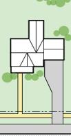
1105.05 SIDEWALKS AND BIKE PATHS
(a) Sidewalks and/or bike paths shall be installed on both sides of all streets at the time of the construction of the street. Sidewalks shall be constructed of Portland cement concrete or other similarly durable and navigable material and shall be located with the outside edge 12 inches inside the right-of-way boundary. The minimum thickness of sidewalks shall be four inches; however, at driveways and other points of vehicle crossing, the thickness shall be six inches. For commercial or industrial driveways where heavy truck traffic is present, thickness shall be eight inches. Sidewalks shall extend to the street at all intersections and shall include wheelchair ramps. Sidewalk shall be of a minimum width as indicated below:
Table 1105.02: Sidewalk width standards.
(1) Crosswalks. Crosswalks must be provided on all sides of an intersection. For example, the crossing of two streets must include four crosswalks, or one on each side of the intersection. Crosswalks must meet the following standards:
(i) Crosswalks of all streets, with the exception of collector and arterial streets, must be elevated. An elevated crosswalk must be at least 4 inches higher than the street grade, thereby requiring vehicles to slow upon approach and mounting of the crosswalk.
(ii) All crosswalks must be at least 10 feet in width, not including ramped areas of elevated sidewalks.
(iii) All crosswalks must be equipped with permanent indicating signage, including the following text: “State Law: Yield to Pedestrians in Crosswalk.”
(2) Bike paths. Bike paths shall be installed to provide non-motorized connections to all parks, schools, adjacent neighborhoods, commercial areas, existing bike paths, etc.. All bike paths shall be at least 10 feet in width and shall be constructed of Portland concrete, asphalt, or a similarly durable and navigable material. Bike path stubs must be included wherever a street stub is constructed in order to facilitate connectivity with future development of adjacent parcels.
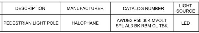
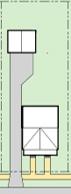
1105.06 STREET LIGHTING
(a) Street lighting shall be required for all new planting strips for streets on residential blocks with at least four lots per 500 linear feet of frontage.
(b) Street lighting shall comply with regulations in Title Three, Section 1141.10.
(c) Street lighting shall be full cutoff type, and shall be designed, selected, and installed by the subdivider following the recommendations of the 8th Edition of the Lighting Handbook of the Illuminating Engineering Society (IES) of North America.
(d) Street lighting shall be directed towards street, sidewalk, and bikeway surfaces only.
(e) Illumination provided shall be uniform and compatible with adjacent light sources. Lamps shall be controlled by dusk-to-dawn photocells.
1105.07 LOTS
Each lot shall have access to a public or private street.
1105.08 TRAFFIC AND STREET SIGNS
All traffic and street name signs shall be installed by the subdivider and shall conform to the requirements as set forth by the Engineer. A schedule of traffic signs conforming to the Ohio Manual of Uniform Traffic Control Devices as updated 12-22-05, shall be submitted to the Engineer for review and approval.
1105.09 WATER
(a) Evidence that the construction plans of the water supply system have been approved by the Municipal Administrator and the Engineer shall be submitted to the Zoning Administrator prior to approval of the Final Plat.
(b) Adequate public water service shall be provided for all lots in conformance with the following criteria:
(1) All water mains, service lines, and appurtenances shall be constructed in accordance with the rules, standards, and specifications of the City of Columbus construction material specifications and appendix or Plain City specifications document and shall be approved by the Engineer prior to acceptance by Council.
(2) Minimum cover depth of buried pipes shall be 48 inches.
(3) Wherever practical, water mains shall be laid within the right-of-way.
(4) All water mains over 600 feet in length shall be looped to provide a second source of supply.
(5) Water mains shall be laid at least 10 feet horizontally from any existing or proposed sanitary or storm sewer or force main. The distance shall be measured edge-to-edge. In cases where it is not practical to maintain a 10-foot separation, the Municipality may allow deviation on a case-by-case basis as approved by the Engineer, provided that the bottom of the water main is at least 18 inches above the top of the sewer.
(6) Water mains that cross sewers shall be laid to provide a minimum vertical distance of 18 inches between the outside of the water main and the outside of the sewer. This shall be the case where the water main is either above or below the sewer. At crossings, one full length of water pipe should be located so both joints will be as far from the sewer as possible. Special structural support for the water and sewer pipes may be required. At all crossings of sewers and other utilities, compacted granular material is required between the deeper and shallower pipe.
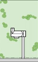
Figure 1105.01: Standard detail for street light in residential planting strip.
(c) The following requirements shall be met for fire protection:
(1) In an area with predominantly one-unit dwelling uses, there shall be a minimum distribution of fire hydrants on a ratio of one to each 120,000 square feet of area. The distance between fire hydrants shall not exceed 400 feet, and one hydrant shall be placed within 200 feet of the end of a cul-de-sac or dead-end street.
(2) In an area with predominantly commercial, business, industrial, and multi-unit dwelling uses, there shall be a distribution of public and/or private fire hydrants on a ratio of one to each 80,000 square feet of area. A minimum of one hydrant shall be provided within 300 feet of every building or part thereof with a minimum of one additional hydrant within 500 feet of every building or part thereof.
(3) Fire hydrants shall be placed two feet clear behind the back of the curb, whenever possible, or eight feet clear behind the edge of pavement in uncurbed streets.
(4) Fire hydrants shall be placed a minimum of 40 feet from buildings whenever possible.
(5) Fire hydrants shall be located at all intersections and approximately in the center of the frontage of any proposed lot.
(6) Computations shall be required to verify that the minimum fire hydrant flow in the proposed improvement meets the requirements for the appropriate insurance ratings. The computations shall be based on a Hazen Williams coefficient of 100. For areas dominated by one-unit dwelling uses, the fire flow should be 1,000 gallons per minute (gpm) at 20 pounds per square inch (psi). For areas dominated by industrial, multi-unit dwelling, or commercial uses, the fire flow should be a minimum of 2,000 gpm at 20 psi. Higher flows may be required depending on the type of use. Fire flows shall be provided in addition to maximum daily requirements.
(7) Fire hydrants shall conform to AWWA C502 and shall conform to the Plain City Water System Material Specification Sheet. The Water System Material Specification Sheet may be obtained from the Engineer. A drainage sump two feet in diameter and two feet deep shall be excavated below each hydrant and filled with coarse gravel or stone, compacted in place, under and around the shoe of the hydrant and to a level of six inches above the waste opening. No drainage sump shall be connected to a sanitary sewer. A hydrant wrench shall be furnished to the Municipal Administrator with each five hydrants or fewer furnished.
(d) Valves shall be placed outside of pavement wherever practical. In general, two valves shall be installed at every main line tee, and three valves shall be placed at every main line cross. The maximum distance between main line valves shall be 1,000 feet. All valves shall conform to the Plain City Material Specification Sheet. The Water System Material Specification Sheet may be obtained from the Engineer.
(e) At high points in water mains 12-inch diameter and larger where air can accumulate, provisions shall be made to remove the air by means of hydrants or manual air relief valves.
(f) All tees, bends, plugs, and hydrants shall be provided with reaction blocking, tie-rods, or joints designed to prevent movement. Tie-rods shall be minimum 3/4-inch diameter and coated with epoxy or two coats of bitumastic material equal to Inertol No. 49 Thick. All water mains provided with reaction blocking shall be wrapped with 8-mil polyethylene film for ease of future reaction blocking removal.
(g) Meters shall be supplied by the Municipality and paid for by the customer.
(h) The subdivider shall provide the Municipal Administrator with all required OEPA approvals and pay all OEPA review fees.
1105.10 SANITARY SEWERS
Each lot shall be served by an adequate sanitary sewage collection and disposal system. Evidence that the sewer construction plans have been reviewed and approved by the Engineer shall be submitted to the Zoning Administrator prior to approval of the final plat.
(a) All sanitary sewage collection systems shall be constructed in accordance with the rules, regulations, standards, and specifications of the City of Columbus 10 State Standards construction material specifications, EPA, and the Ohio Department of Health, and shall be approved by the Engineer prior to acceptance by the Council.
(b) Only under circumstances of extreme hardship, and with the approval by the Engineer and the Council, shall sewage lift stations or sewage grinder pumps be permitted. Where approved, such systems shall meet the standards and specifications of the Engineer and the Municipality. No individual household sewerage systems are to be permitted.
(c) A map must be provided delineating the contributing area in acres to the sanitary sewer system. All sanitary sewer manholes shall be numbered, consistent with the numbering on the improvement plans. A copy of the location map may be used for this purpose.
(d) Wherever practical, sanitary sewers shall be laid within or adjacent to the right-of-way.
(e) The subdivider shall provide the Municipal Administrator with all required OEPA approvals and pay all OEPA review fees.
(f) Service shall be provided to each lot and to each unit of a multi-unit structure. If basement service is not provided, it shall be so noted on the sanitary sewer improvement plans and on the plat. Risers shall be provided where the service is greater than 12 feet deep, provided that basement service will still be provided. In cases of multi-unit apartments or condos, if the units are master-metered for water service, one service shall be provided lateral to the building.
(g) All sanitary sewers shall be videorecorded after construction prior to acceptance of the sewers by the Council. The videorecord shall remain the property of the Municipality and shall be maintained by the Municipal Administrator. The videorecord shall clearly identify the location of the camera within the sewer and date and time of videorecord, and be of sufficient quality to determine the acceptable condition of the sewers.
1105.11 DRAINAGE
An adequate storm drainage system shall be provided for each subdivision. The design of said system shall be prepared using the Rational Method and shall be based on a minimum 2-year frequency. Rainfall intensity, runoff coefficients, and concentration time used in computing flows and structure sizes shall be in accordance with the tables, charts, and the data established by the Engineer for such calculations. All areas which contribute storm water to the proposed drainage system must be considered on the determination of the sizes of structures and channels.
(a) A separate grading plan shall be submitted at a scale of 1” = 50’ or 1” = 100’. The grading plan shall indicate ground elevations with existing and proposed contours shown at intervals of not more than five feet where the slope is greater than 10 percent and not more than two feet where the slope is less than 10 percent. Sufficient proposed elevations shall be shown such as at all lot corners in order to explain the proposed grading. First floor elevations of all existing and proposed structures shall be included. Routing of the major storm shall be shown. Sanitary sewer and storm sewer top of castings must be shown on the grading plan.
(b) The minimum building elevation adjacent to the 100-year routing path shall be set a minimum of one foot above the 100-year flood elevation. No basement entrances, windows, or basement level garages shall be permitted adjacent to and below the 100-year routing path.
(c) Swales necessary to carry surface water must have a minimum gradient of one percent.
(d) Open Watercourses
(1) Maintenance access to storm drainage ditches and channels shall be assured by means of maintenance easements. Such maintenance easements shall be not less than 20 feet in width, measured horizontally from the top of the bank, exclusive of the width of the ditch or channel, and shall be provided on each side of the ditch.
(2) Maintenance easements are to be kept free of obstructions. Detailed provisions regarding the entities to be responsible for maintenance of the facility shall be submitted in text form with the subdivision plat. As applicable, notes regarding maintenance shall be made on the plat.
(3) Design storm frequency for open channels shall be based on bank full for 10-year storm, with a one-foot freeboard.
(4) The minimum velocity for open channels shall be two feet per second. The maximum velocity is dependent on the type of channel protection provided. The desirable minimum grade for an open channel is 0.4 percent.
(5) The Manning “n” values shall be as follows:
Sod or jute mat lining: 0.05
Paved lining: 0.015
Rock protection: 0.08
Manning “n” values for other lining materials will be reviewed by the Engineer on a case-by-case basis.
(6) If the proposed improvements are located in a floodplain area as identified by FEMA, the limits of the floodway and floodway fringe must be shown on the final plats.
(e) Roadway Culverts
(1) Single-span culverts, including concrete box or slab top, should always be considered in lieu of multiple-cell pipe culverts in order to meet the physical requirements introduced by rigid headwater controls.
(2) The plan for each culvert shall indicate the drainage area in acres and the design discharge in cubic feet per second.
(3) The culvert invert elevation should be set such that it will be deep enough to provide an adequate outlet for future storm sewer improvements upstream.
(4) The design storm frequency for culverts is 10 years for local roadways or cul-de-sacs, 25 years for collector roadways, and 50 years for arterial roadways, or as otherwise approved as required, with a maximum allowable headwater of 12 inches below edge of pavement with consideration for effects on upstream property.
(5) The Manning “n” values shall be as follows:
Box culvert: 0.011
Slab top culvert: 0.03-0.05
Smooth pipe: 0.012
(6) The minimum cover to sub grade shall be nine inches from top of pipe to bottom of sub grade. The structural design of culverts shall be the same as that required by the Ohio Department of Transportation, Construction and Material Specifications Section 706.05 for culverts with a span of 12 feet or less. Design calculations for all culverts shall be approved by the Engineer.
(f) Stormwater Detention
(1) If the post-development runoff volume is greater than the pre-development runoff volume, stormwater detention must be provided to detain such increase in runoff volume per critical storm method:
(2) The maximum allowable release rate from any storm sewer outfall shall be based on the two-year storm under pre-developed site conditions per critical storm method.
(3) Urban Hydrology for Small Watershed, Technical Release No. 55 should be used to determine predevelopment and post-development runoff volumes. Required detention volume calculations shall be based on Chapters 4 and 6 of TR-55.
(4) Detention basins shall have a minimum one percent transverse slope.
(5) All stormwater detention facilities shall be owned and maintained by a homeowners’ association comprised of properties served by the detention facility. Such homeowners’ association shall be established and inserted into the chain of title of each lot within such subdivision.
(6) All control facilities shall be designed with overflow provisions to handle the post-development 100-year discharge.
(7) For more information on Sustainable BMPs for Water Quality, see Chapter 1151: Appendix.
1105.12 STORM SEWER DRAINAGE
(a) Storm Sewer Requirements
(1) Minimum cover for storm sewer pipe shall be one foot clear from the bottom of the curb and gutter or from the bottom of the underdrain to the outside top of the pipe, except as approved by the Engineer. Storm sewer pipe must maintain a minimum of two feet of cover from the finished ground surface to the outside top of the pipe for any storm sewer system located beyond the limits of street right-of-way.
(2) Standard headwalls are to be constructed at the inlet and outfall of all storm sewers, and shall be shown on the plan and profile.
(3) The invert of the first storm sewer appurtenance shall be above the computed floodplain elevation, unless otherwise permitted by the Engineer.
(4) Pipe for storm sewers shall not be less than 12 inches in diameter. All storm sewer pipe shall be extra strength vitrified clay, reinforced concrete, or smooth lined corrugated polyethylene pipe. Other materials shall require the approval of the Engineer. All pipe installations shall have sufficient strength to withstand an HS-20 live load.
(5) A stormwater management report shall stay on file with the project.
(6) The inverts of all curb inlets, manholes, yard inlets, and other appurtenances shall be formed to reduce turbulence to a minimum.
(7) Manholes shall be provided at all changes in alignment and grade of storm sewers and at such other locations as necessary to maintain a maximum interval of 500 feet between manholes or storm sewers.
(8) Storm inlet or catch basin grates shall be of a type to permit safe crossing by bicycles as approved by the Engineer.
(9) The maximum distance for overland flow shall be 300 feet before entering a surface yard inlet or 425 feet before entering a curb inlet, except that the maximum overland drainage area contributing to any yard inlet or curb inlet shall not exceed 1.5 acres. The maximum spacing for curb inlets shall not exceed 400 feet unless approved by the Engineer. The maximum spread of flow during a 2-year storm shall not exceed eight feet for 30-foot wide streets and nine feet for streets wider than 30 feet. Spread calculations may be required at the discretion of the Engineer.
(10) The flow lines of pipes shall be set such that either the crown or the 0.8 depth points at junctions are at the same elevation. However, the crown of the outlet pipe may be lower.
(11) Where a 72-inch pipe is inadequate for a two-year storm, an open watercourse may be permitted. When so permitted, an easement shall be provided at least equal to the area required for the 100-year rainfall. The easement shall be shown on the final plat as a “Watercourse and Utility Easement.” Restrictions as to the use of this easement shall be shown on the final plat. No buildings, plantings, or other improvements shall be permitted within that easement.
(b) Storm Sewer Design Criteria
The method outlined herein will provide a general guide as to the criteria and procedures to be used for storm sewer design.
(1) No rooftop, parking area, or street shall be connected directly to storm sewer inlets via ungrassed conveyances, such as gutters, downspouts, roadways, or channels. All impervious surfaces shall be separated from storm sewer inlets by at least 5 feet of vegetated land area.
(i) Adequate horizontal distribution of storm water flows must be maintained in order to reduce the erosive force of peak flows.
(ii) The maintenance of vegetated areas receiving storm water flows is the responsibility of the landowner. Bare soil and rill and/or gully erosion are indications of inadequate maintenance or over-concentration of flows.
(2) The Rational Method shall be used for all stormwater drainage design for areas up to 200 acres. Storm sewers shall be designed to carry a two-year storm flowing full Q = CIA, in which:
Q = Quantity of stormwater runoff in cubic feet per second
C = Coefficient of runoff (0.4 for single-family residential areas)
I = Average rainfall intensity in inches per hour for the period of concentration to the point under consideration. The minimum length of time of concentration is 10 minutes to a curb inlet or 15 minutes to a ditch catch basin.
A = Drainage area in acres tributary to the point of concentration.
(3) For drainage areas over 200 acres, the method explained in “Urban Hydrology for Small Watershed, Technical Release No. 55” (known as TR-55), dated June 1986, and the “Ohio Supplement to Urban Hydrology for Small Watersheds, Technical Release No. 55,” dated April 1981, shall be used.
(4) The minimum time of concentration to the first inlet shall be 10 minutes. The minimum time of concentration to the first catch basin shall be 15 minutes. The elevations at the curb line shall be provided to the Municipality in order to assure that this requirement is met.
(5) Storm sewer pipe sizes are to be determined by using Manning’s Formula with a minimum coefficient of roughness of n = 0.013.
(6) The minimum allowable velocity shall be three feet per second (fps) in pipe. The maximum allowable velocity shall be seven fps.
(7) A hydraulic grade line check based on a five- or ten-year storm may be required at the discretion of the Engineer.
1105.13 BRIDGES
Bridges over walkways or watercourses shall be designed in conformance with the most recent publication of the Ohio Department of Transportation Bridge Design Manual. Calculations shall be submitted to the Engineer to demonstrate that these standards have been met.
1105.14 EROSION AND SEDIMENT CONTROL
Measures shall be taken to minimize erosion and its impact during subdivision construction activity consistent with the requirements of Title Three Section 1141.15. Detailed erosion, sediment, and stormwater control plans as described in Title Three Section 1141.15 shall be submitted with the final plats and shall indicate the techniques to be used both during construction and post-construction. All erosion control devices shall be in place at the start of construction and other measures shall be implemented according to the approved time schedule.
1105.15 STREAM OR DRAINAGE CHANNEL RELOCATION PROHIBITED
Streams and other drainage channels may not be relocated or channeled as a part of any subdivision.
1105.16 ENVIRONMENTAL STANDARDS
(a) Land Suitability. Land which experiences flooding, improper drainage, slopes, geology, unfavorable soil conditions, threatened water quality or quantity, utility easements, or other features which may reasonably be harmful or detrimental to safety, health, environmental quality, and general welfare shall not be approved by the Commission to be subdivided or developed unless measures adequate to resolve the problems are formulated by the applicant and approved by the Commission. The Commission must find that a proposed subdivision meets the following standards.
(b) Floodplain. The creation of new building sites in floodplain areas is discouraged. When a portion of the property is in a floodplain, the subdivider shall include the location in the plat drawings.
The following sources shall be used to determine floodplain area:
(1) National Flood Insurance Program (NFIP) maps and data;
(2) County Soil Survey; and
(3) Data developed by a registered professional engineer using accepted engineering practices.
(c) Watercourses and Drainage Ways. The applicant shall take steps to assure watercourses, drainage ways, streams, creeks, ditches, and swales continue to function in their natural or intended manner.
(d) Soils with Development Limitations. Soils with potential wetness, drainage or strength limitations are identified by the County Soil Survey. The Soil Survey notes limitations for home sites, roads and other development activities. Special street sections shall be required to deal with soil limitations. Plat wording or deed restrictions shall be required to alert future owners of lots of potential limitations or to otherwise specify development conditions or restrictions.
(e) Wetlands. In addition to the standards in these Subdivision Regulations, the U.S. Army Corps of Engineers and the OEPA have jurisdiction over wetlands. Subdivision approvals shall be denied if the subdivider or developer fails to secure proper wetlands permits.
(f) Wooded Areas. When wooded areas are developed, the developer shall plan for the retention of as many trees and as much of the area’s character as possible, consistent with the requirements of Section 1141.19. Care should be taken to maximize the aesthetic value of the trees. Development impacts shall be minimized with proper construction and urban forestry management practices.
1105.17 LANDSCAPING
(a) All improved areas within dedicated street rights-of-way shall be graded, topsoiled, and seeded in accordance with the construction schedule and in a manner approved by the Engineer.
(b) Street trees shall be required and planted in accordance with an approved tree preservation plan, as described in Title Three Section 1141.19 and ANSI 3000 construction and planting standards.
(c) The number, type and location of trees planted shall be based upon the existing trees preserved on the site and shall be shown on a tree preservation plan to be submitted with the final plat. Tree preservation plans shall be in accordance with a master tree plan.
(d) The builder shall be responsible for the establishment of required trees and such responsibility shall extend for two years from the date of original planting.
(e) A bond shall be posted to ensure the planting and replacement of trees. The amount of said bond shall be based on the estimated cost of planting and establishing the required trees, and may be reduced as trees are planted.
(f) Irrigation Systems. An irrigation system shall not be allowed within the right-of-way, unless approved by the Commission. If said approval is given, the location of the irrigation system must be included on the final plat. In addition, a waiver must be signed which holds the Municipality harmless for improvements in the right-of-way that require the relocation or removal of the irrigation system.
(g) Interior Landscaping Requirements
(1) On a lot with a front setback of 20 feet or greater to the principal structure, there shall be planted a minimum of one tree per 20 feet of lot frontage. Such tree(s) shall be planted in the front yard. Such tree(s) shall be planted at the time of development.
(2) On a lot with less than 20 feet of front setback to the principal structure, there shall be planted a minimum of one tree per 30 feet of lot frontage. Such tree(s) shall be planted at the time of development. Such tree(s) shall be planted in the front yard at the unless the front yard, due to its depth, is inadequate in facilitating the growth of such tree(s), in which case the required tree(s) may be planted in other yards on the lot.
(3) Trees shall meet the same standards as for the street trees of the subdivision. Trees shall not be planted closer than five feet to a side lot line.
(4) When calculating the lot frontage for corner and through lots, all frontages shall be considered, and trees shall be evenly distributed along frontages when practicable.
1105.18 SUBDIVISION SIGNS
The developer of each subdivision, other than a minor subdivision, may erect on the site of said subdivision, informational signs meeting the following criteria:
(a) Permanent Signs. Permanent signs may include traffic and parking control signs. Each pedestrian pathway or bikeway must include directional signage indicating the destination of such pedestrian pathway or bikeway and indicate the accessibility of such pathway or bikeway with terms “Paved” and “Public.” Permanent signs may be illuminated as permitted in the comprehensive sign table in the Zoning Ordinance.
(b) Temporary Signs. Temporary signs in a subdivision may include signs advertising the sale of platted lots in a subdivision, provided that there is not more than one of such sign facing any one street. Such signs are limited to 24 square feet in area and eight feet in height, limited to one year in duration, and may not be located closer than 15 feet to a public right-of-way.
Construction signs announcing the names of contractors, materials, developers, designers, and financial institutions participating in the construction of a building shall be permitted only during the actual time of construction and shall be limited to only one sign per project, shall not exceed 20 square feet in area for a residential project and 32 square feet for a non-residential or mixed-use project, shall not exceed four feet in height for a residential project and 10 feet in height for a non-residential or mixed-use project, and shall not be located closer than 15 feet from any public right-of-way. Such signs shall be removed within 30 days after a Certificate of Zoning Compliance is issued for the property.
(c) Maintenance of Subdivision Signs. Maintenance of all signs shall be the responsibility of the developer during the construction process. Maintenance of all signs shall be the responsibility of the landowner after the construction process has finalized.
1105.19 HILLSIDE REGULATIONS
(a) Cuts and Fills. No land shall be graded, cut, or filled so as to create a slope exceeding a vertical rise of one foot for each 3 feet of horizontal distance between abutting lots, or between adjoining tracts of land, unless a retaining wall of sufficient height and thickness is provided to retain the graded bank, or other acceptable control measures are provided.
(b) Compaction of Fill. All fill outside the right of way shall be compacted to a density of 90 percent dry density or greater, to within four inches of finished grade.
1105.20 PUBLIC SITES AND OPEN SPACES
(a) Relationship to Comprehensive Plan. Where a proposed conservation area, park, or school site, as shown in the comprehensive plan or other officially adopted planning documents, is located in whole or in part within a proposed subdivision, the Commission may require the following:
(1) The dedication to the public of part or all of the proposed site, as discussed below, and/or (2) Reservation of the site for a period of up to three years to enable acquisition by the appropriate agency.
(b) Minimum Dedication Requirements for Open Space. The subdivider shall reserve a minimum of 25 percent, unless greater standards are required by the development standards of the district.
(c) The open space shall either be dedicated to the Municipality or to another public agency which has expressed a desire to accept and maintain the open space, or it shall be transferred to a private association or entity with a mission to preserve land in perpetuity for the promotion of public health and environmental quality. The Municipality shall be given the right of first refusal. If the open space is transferred to a private association or entity, acceptable provisions for the perpetual maintenance of the open space shall be stated on the final plat.
(d) The Zoning Administrator shall have the authority to determine whether or not the proposed open space and maintenance provisions are acceptable. Lands used for sewage, stormwater detention/retention, and/ or other utilities shall not be considered open space for the purposes of these Subdivision Regulations unless such land use has a dual or elevated purpose and considered both functional and aesthetic.
(e) Payment in Lieu of Open Space Dedication. When the Commission and/or Zoning Administrator determines that open space dedication is not desirable within a proposed subdivision, the subdivider shall be required to pay a fee in lieu of open space dedication. The fee shall be collected at the time final plat approval is requested.
(1) As to residential property the fee shall be calculated as follows:
Total land dedication required in acres = A
Value of land per acre = B
Fee in lieu of land dedication = A x B
(2) Determining value of land per acre. This amount shall be determined in the following manner:
(i) If the property has been sold within the past two years, and if the Municipality does not exercise its ability to independently appraise the property, this value shall be determined by dividing the most recent sales price by the total number of acres of the property;
(ii) If the property has not been sold within the past two years, and if the Municipality does not exercise its ability to independently appraise the property, this value shall be determined by a fair market valuation provided by the subdivider and performed by a qualified land appraiser acceptable to the Municipality;
(iii) If the Municipality so elects, and notwithstanding the foregoing provisions of this section, this value shall be determined by a fair market valuation performed by a qualified land appraiser employed by the Municipality. If such an appraisal is elected, it shall be final and dispositive of the valuation issue.
(3) For each lot or parcel intended for commercial, office, or other business or industrial use, the in lieu fee shall be at the rate of $1,500 for each acre of such lot or parcel.
(f) Minor Subdivision. Minor subdivisions shall not be exempt from open space dedication or payment in lieu of dedication requirements. Minor subdivisions shall not be exempt from the park fee.
1105.21 SEWAGE DISPOSAL AND WATER SUPPLY
Connection to central sewer and water systems shall be required for all major subdivisions within the Municipality.
1105.22 PRIVATE UTILITIES
All proposed utilities (including gas, electric, telephone, and CATV cables) shall be located underground throughout the subdivision, unless otherwise approved by the Municipal Administrator and Engineer. Wherever existing utility facilities are above ground they shall be relocated underground, wherever possible.
1105.23 PROTECTION OF WELLS
(a) Where a subdivision is proposed to be located in an area in which there are existing water wells within 300 feet of proposed sanitary sewers or other potential pollution sources, the Commission or Engineer may require that information be provided by the developer sufficient to determine the potential impact of the installation of underground utilities within the subdivision on the water table servicing said wells. The Engineer shall determine if a high probability for impact exists. If so, the Engineer may require that an approved barrier method be placed on underground lines in such locations as the Engineer shall designate to control said impact.
(b) A permanent easement is required within 300 feet of a public water supply well to provide a sanitary control radius of protection.
(c) All subdivisions must comply with the Wellhead Protection Buffer standards found in Title Three Section 1137.17.
(d) Furthermore, the Municipality may require wellhead protection easements in accordance with the Wellhead Protection Plan on file with the Municipality.
Title Three: Zoning Ordinance
To promote the public health, safety, convenience, comfort, prosperity, and general welfare.
Introduction to the Zoning Ordinance
1135: Introduction to the Zoning Ordinance
1135.01 DESIGNATION
Title Three of Part Eleven of the Plain City, Ohio, municipal code is hereby established and referred to as the Zoning Ordinance.
1135.02 EFFECTIVE DATE
This Zoning Ordinance shall be in force on the earliest date allowed by law.
1135.03 PURPOSE
The regulations in this Zoning Ordinance are established for the promotion of public health, safety, convenience, comfort, prosperity, and general welfare.
1135.04 JURISDICTION
The provisions of the Zoning Ordinance shall apply to all land, structures, and uses now within and hereafter annexed to the Municipality.
1135.05 REPEAL OF PRIOR ZONING ORDINANCE
This Zoning Ordinance replaces and effectively repeals any prior zoning ordinance in effect in the City. All ordinances or parts of ordinances of the City, in conflict with any regulation, provision, amendment or supplement of this Zoning Ordinance are, to the extent of such conflict, hereby repealed.
Any enforcement action pending under the prior zoning ordinance at the date of enactment of this Zoning Ordinance shall continue, provided that the violation is not made legal by the enactment of this Zoning Ordinance.
1135.06 CONTINUANCE
The Zoning Ordinance shall not require any change in the plans, construction, size, or designed use of a structure for which a valid permit has been issued or lawfully approved before the effective date of this Zoning Ordinance, provided, however, that construction under such permit or approval was started within one year and ground story framework, including structural parts of the second floor, if any, is completed within one year of the effective date of this Zoning Ordinance. Extension may be granted for unforeseen circumstances as deemed appropriate by staff.
Nothing contained in this Zoning Ordinance shall affect the validity or effectiveness of an existing Conditional Use Permit issued under the prior zoning ordinance and as thereafter amended and effective prior to the enactment of this Zoning Ordinance.
1135.07 CONFLICTING PROVISIONS
Where the provisions of this Zoning Ordinance establish greater restrictions on a lot, a structure, or a use than the provisions of any other ordinance or regulation, private deed restriction, or private covenant, the provisions of this Zoning Ordinance shall govern. Where the provisions of another ordinance, regulation, private deed restriction, or private covenant establish greater restrictions than the provisions of this Zoning Ordinance, then provisions of the other ordinance, regulation, private deed restriction, or private covenant shall govern.
1135.08 PRIVATE PROVISIONS
The provisions of this Zoning Ordinance are not intended to nullify, abolish, or repeal any easement, covenant, or other private agreement or restriction.
1135.09
COMPLIANCE REQUIRED
Compliance with this Zoning Ordinance is required. Failing to comply with the regulations of the Zoning Ordinance shall constitute a violation of its provisions.
1135.10
SEVERABILITY
If any section, subsection, sentence, clause or phrase of this Zoning Ordinance is held to be invalid, such invalidity shall not affect the validity of the remaining portions of this Zoning Ordinance.
1135.11 MINIMUM REQUIREMENTS
(a) Except as hereinafter provided, no structure or part thereof shall be moved, erected, converted, enlarged, reconstructed, or structurally altered except in compliance with the regulations of this Zoning Ordinance.
(b) No structure or land shall be used or occupied except in compliance with the regulations of this Zoning Ordinance.
(c) No structure shall be erected or structurally altered except when such structure is located on a lot.
(d) No lot shall be created or changed in dimension or area except in conformity with the requirements set forth in this Code.
1135.12 RULES OF INTERPRETATION
(a) Interpretation of Terms and Words
(1) Except where specifically defined in the Zoning Ordinance, all words used in the Zoning Ordinance shall carry the meanings contained in a dictionary of common usages.
(2) Words used in the present tense include the future tense; the singular number includes the plural, the word “structure” includes the word “building”; the word “lot” includes the word “plot” or “parcel”; the term “shall” is always mandatory; the word “may” is permissive; the words “used” or “occupied”, as applied to any land or structure shall be construed to include the words “intended, arranged or designed to be used or occupied”.
(b) Interpreting Conjunctions
Where a regulation involves two or more items, conditions, provisions, or events which are connected by a conjunction—”and”, “or”, or “either...or“—the conjunction shall be interpreted as follows:
(1) “And” indicates that all the connected items, conditions, provisions, or events shall apply.
(2) “Or” indicates that the connected items, conditions, provisions, or events may apply singly or in any combination.
(3) “Either ... or” indicates that all the connected items, conditions, provisions, or events shall apply singly but not in combination.
(c) Interpreting Text and Graphics
(1) Text in the Zoning Ordinance is regulatory.
(2) Graphics in the Zoning Ordinance are illustrative unless specifically captioned as regulatory.
(d) Interpreting Zoning Map Boundaries
(1) Boundaries indicated as approximately following the centerlines of streets, highways, or alleys; platted lot lines; municipal limits; railroad lines; or the centerlines of streams, rivers, canals, lakes, or other bodies of water shall be construed as such.
(2) Where district boundaries are so indicated that they are approximately parallel to the center lines or street lines of streets, or the center lines or right-of-way lines of highways, such district boundaries shall be construed as being parallel thereto and at such distance therefrom as indicated on the Zoning Map. If no distance is given, such dimension shall be determined by the use of the scale shown on the Zoning Map.
(3) Where a district boundary line divides a lot that was in single ownership at the time of passage of this Zoning Ordinance, the Zoning Administrator or their designee may permit the extension of the regulations for either portion of the lot beyond the district line into the remaining portion of the lot.
1135.13 RULES OF MEASUREMENT
(a) Measuring Lot Dimensions
(1) A lot extends to its lot lines, which should be coterminous with the lot lines of abutting lots or with the boundaries of a public right-of-way.
(2) Area dimensions are measured on a horizontal plane in plan view and do not consider topography or the actual surface area of non-level ground.
(3) Areas of lots that are occupied by easements, such as access or utility easements, contribute to total lot area and are considered in calculating impervious coverage and other standards.
(4) Lot frontage. Lot frontage is the aggregate length of all front lot lines (see Figure 1135.01).
(5) Impervious coverage. Impervious coverage is the percent of the lot’s horizontal plane that is occupied by impervious, man-made materials, including buildings, asphalt, concrete, swimming pools, barns, and carports, but excluding porous pavement, permeable pavers, decks with gaps between decking for drainage, lawn grasses, gardens, and other landscaping.
(b) Measuring Setbacks
(1) When measuring a required distance, such as the minimum setback, the measurement is made at the point where the two entities are closest (see Figure 1135.02).
(2) Where a lot borders two streets that do not intersect at a corner of the lot, such as in a through lot, two front lot lines will exist, one along each right-ofway. The required front setback must be provided for each street frontage. Lot lines abutting alleys are not considered front lot lines and do not require front setbacks.
(3) When a lot borders two or more streets that intersect at a corner(s) of the lot, such as in a corner lot, the front setback shall be provided for each street
Figure 1135.01: Lot frontage
The graphic above shows the lot frontage of a corner lot: the sum of the lengths of the arrows. The alleyway does not constitute a street right-of-way for the purposes of this Zoning Ordinance, and the lot line that abuts the alleyway is, therefore, not included in the measurement of lot frontage.
Figure 1135.02:
Setbacks as shortest distances
The graphic above shows the front setback as the measure of the length of the arrows. The front setbacks are measured from front lot lines to the nearest point on the nearest structure. Note that the alleyway does not constitute a street right-ofway for the purposes of this Zoning Ordinance, and, therefore, a front setback is not applied at the alleyway. The front steps are not considered when measuring the setback.
frontage. Lot lines abutting alleys are not considered front lot lines and do not require front setbacks.
(4) When a lot borders one street with an acute curve of 55 degrees or more so that the street effectively creates two sides of the lot, the lot line(s) along that street shall be considered a front lot line, and a front setback shall be applied to the entire lot frontage.
(c) Measuring Structure Height
Structure height is measured as the difference in elevation of:
(1) A horizontal line at the average grade along the structure’s front elevation; and
(2) The highest point of a coping flat roof; the top of a mansard roof; the midpoint of any pitched gable, the midpoint of any hip roof, the midpoint of the upper portion of a gambrel roof; or the midpoint between the top floor ceiling and peak of an “A” frame roof (see Figure 1135.03).
1135.14 EXCEPTIONS TO SETBACK AND HEIGHT REGULATIONS
(a) Permitted Exceptions to Minimum Setback Regulations
(1) An open porch may have a front yard setback equal to eight feet less than the front yard setback defined for principal structures in the district.
(2) A deck or patio may extend into a rear yard setback 10 feet for principal structures in the district.
(b) Permitted Exceptions to Maximum Structure
Height Regulations
(1) Renewable energy generation systems may exceed the maximum structure height defined for the district by up to five feet.
(2) Chimneys, elevators, poles, spires, tanks, towers, and other similar projections may exceed the maximum structure height defined for the district by up to 14 feet.
(3) Spires and steeples on structures used for religious assembly shall not be subject to structure height limitations.
1135.03: Structure height
The graphic above shows the height of the structure as the length of the two-sided arrow. It spans the difference in elevation between the horizontal line at the average grade along the structure’s front elevation and the top of the roof.
Figure 1135.04: Structure height on steep grade
The graphic above shows the height of the structure as the length of the two-sided arrow. It spans the difference in elevation between the horizontal line at the average grade along the structure’s front elevation and the top of the roof.
Figure
ILLUSTRATION OF DIMENSIONAL STANDARDS
Below are illustrative graphics indicating the measures of lot frontage, front setback, side setback, rear setback, lot area, and impervious coverage. These dimensional terms are also defined in the Glossary, Chapter 1149.
1135.05: Illustration of lot frontage, front setback, side setback, and rear setback dimensions.
1135.06: Illustration of lot area and impervious coverage dimensions.
Figure
Figure
Districts
1137: Districts
1137.01 INTRODUCTION TO DISTRICTS
(a) Establishment of the Zoning Map
The Municipality is divided into districts as shown on the Zoning Map, which, together with all explanatory matter thereon, is adopted by reference and declared to be a part of this Zoning Ordinance.
(1) The Zoning Map shall be the authority as to the current zoning status of structures and lots in the Municipality.
(2) No changes of any nature shall be made in the Zoning Map or matter shown thereon except in accordance with the procedures set forth in this Zoning Ordinance. Any unauthorized change of whatever kind by any person or persons shall be considered a violation of this Zoning Ordinance.
(3) The Zoning Map shall be maintained in an accurate manner and available to the public at the Municipal offices and online at https://www.plain-city.com/planning---zoning.
(b) List of Districts
The Municipality includes the following districts:
(1) Agricultural District (A-1)
(2) Rural Residential District (RR)
(3) Suburban Residential District (SR)
(4) Uptown Neighborhood District (UN)
(5) Village Residential District (VR)
(6) Uptown District (UP)
(7) Corridor District (C)
(8) Innovation and Employment District (IE)
(9) Open Space District (OS)
(c) Purpose of Districts
(1) Districts intend to promote compatible land uses within a defined geographic area by establishing limitations on the use, placement, and scale of structures within the district.
(2) One district designation may be applied to numerous, non-contiguous geographies that share existing or desired development patterns.
(d) Compliance with Regulations
Specific standards by district are set forth in this chapter. Additional development standards are included elsewhere in the Zoning Ordinance, such as use-specific standards in Chapter 1139 or generally applicable standards in Chapter 1141.
1137.02
Agricultural District (A-1)
USES
Agricultural
• Agriculture
Dwelling
• Accessory Dwelling Unit (A)
• One-Unit Dwelling
• Two-Unit Dwelling
Industrial
• Artisan Manufacturing
• Small Food Manufacturing
• Small Scale Light Industrial (C)
• Large Scale Light Industrial (C)
Institutional
• Post-Secondary School (C)
• Primary School
• Religious Place of Worship
• Secondary School
• Technical School (C)
Lodging
• Bed and Breakfast
Recreation and Leisure
• Conservation Recreation
• Large Scale Outdoor Recreation
• Recreation with Lodging
• Restaurant or Bar (C)
• Small Scale Outdoor Recreation
• Specialty Food and/or Beverage Facility (C)
Services
• Air Transport Services (C)
• Animal Care with or without Outdoor Runs
• Professional Services (C)
Note: (C) indicates a use that is conditionally permitted. (A) indicates a use that may be accessory to a principal use.
A Superscript A indicates that, when a conservation development is applied, conservation development standards may apply; see Section 1141.14.
PURPOSE
The Agricultural District intends to promote rural character and economic prosperity through large lots and modern agricultural uses.
DEVELOPMENT STANDARDS
Structure Height for Agricultural Facilities
Table 1137.01: Development standards for the Agricultural District.
Figure 1137.01: An illustrative graphic showing a possible development pattern in the Agricultural District.
1137.03
Rural Residential District (RR)
USES
Agricultural
• Agriculture (C)
• Neighborhood Agriculture (A)
Dwelling
• Accessory Dwelling Unit (A)
• One-Unit Dwelling
• Two-Unit Dwelling
Institutional
• Assembly, Meeting Facilities, and Event Space (C)
• Primary School
• Religious Place of Worship
• Secondary School
• Technical School (C)
Lodging
• Bed and Breakfast
Recreation and Leisure
• Conservation Recreation
• Large Scale Outdoor Recreation
• Recreation with Lodging
• Restaurant or Bar (C)
• Small Scale Outdoor Recreation
• Specialty Food and/or Beverage Facility (C)
Services
• Animal Care with or without Outdoor Runs
Note: (C) indicates a use that is conditionally permitted. (A) indicates a use that may be accessory to a principal use.
A Superscript A indicates that, when a conservation development is applied, conservation development standards may apply; see Section 1141.14.
PURPOSE
The Rural Residential District intends to support low-density residential development compatible in character with a rural landscape.
DEVELOPMENT STANDARDS
Table 1137.02: Development standards for the Rural Residential District.
Figure 1137.02: An illustrative graphic showing a possible development pattern in the Rural Residential District.
1137.04
Suburban Residential District (SR)
USES
No more than one principal use is permitted per lot.
Agricultural
• Neighborhood Agriculture (A)
Dwelling
• Accessory Dwelling Unit (A)
• One-Unit Dwelling
• Two-Unit Dwelling
Institutional
• Arts, Science, and Cultural (C)
• Assembly, Meeting Facilities, and Event Space (C)
• Primary School
• Religious Place of Worship
• Secondary School (C)
• Technical School (C)
Recreation and Leisure
• Conservation Recreation
• Large Scale Outdoor Recreation
• Recreation with Lodging (C)
• Restaurant or Bar (C)
• Small Scale Outdoor Recreation
• Specialty Food and/or Beverage Facility (C)
Sales
• Residential Sales Services
• Family Care Services (C)
Note: (C) indicates a use that is conditionally permitted. (A) indicates a use that may be accessory to a principal use.
A Superscript A indicates that, when a conservation development is applied, conservation development standards may apply; see Section 1141.14.
B Superscript B indicates that in order to vary how buildings are spaced along a block front, one of two required side setbacks must be greater than the minimum side setback of 10 ft.
PURPOSE
The Suburban Residential District intends to support medium-density residential uses in well-connected, walkable neighborhoods.
DESIGN STANDARDS
Development in the Suburban Residential District is subject to the design standards as described in Section 1137.07.
DEVELOPMENT STANDARDS
Lot Area - One Unit Dwelling 8,000 sq. ft. min. A
Lot Area - Two Unit Dwelling 4,000 sq. ft. min. per dwelling unit A Lot Frontage
Setback
Table 1137.03: Development standards for the Suburban Residential District.
Figure 1137.03: An illustrative graphic showing a possible development pattern in the Suburban Residential District.
1137.05
Uptown Neighborhood District (UN)
PURPOSE
Agricultural
• Neighborhood Agriculture (A)
Dwelling
• Accessory Dwelling Unit (A)
• Multi-Unit Dwelling
• One-Unit Dwelling
• Two-Unit Dwelling
Industrial
• Artisan Manufacturing
• Small Food Manufacturing (C)
• Small Scale Light Industrial (C)
Institutional
• Arts, Science, and Cultural
• Assembly, Meeting Facilities, and Event Space (C)
• Government Administration
• Post-Secondary School (C)
• Primary School
• Public Safety
• Religious Place of Worship
• Secondary School (C)
• Technical School (C)
Lodging
• Bed and Breakfast
Multi-Use
• Live-Work Unit
Recreation and Leisure
• Conservation Recreation
• Large Scale Indoor Recreation (C)
• Recreation with Lodging (C)
• Restaurant or Bar
• Small Scale Outdoor Recreation
• Specialty Food and/or Beverage Facility Retail
• Small Scale Retail
Services
• Family Care Services
• General Personal Services
• Professional Services
• Residential Care Services
Note: (C) indicates a use that is conditionally permitted. (A) indicates a use that may be accessory to a principal use.
The Uptown Neighborhood District promotes a pedestrian-friendly, well connected neighborhood within walking distance of the Uptown District.
DESIGN STANDARDS
Development in the Uptown Neighborhood District is subject to the design standards as described in Section 1137.07.
DEVELOPMENT
STANDARDS Lot Area
Front Setback
Side Setback 0 ft. exactly, or more than 4 ft.
Rear Setback
Structure Height
Impervious Coverage
12 ft. min. for principal structures; 5 ft. min. for accessory structures
Table 1137.04: Development standards for the Uptown Neighborhood District.
Figure 1137.04: An illustrative graphic showing a possible development pattern in the Uptown Neighborhood District.
1137.06
Village Residential District (VR)
USES
Agricultural
• Agriculture
• Neighborhood Agriculture (A)
Dwelling
• Accessory Dwelling Unit (A)
• Multi-Unit Dwelling
• One-Unit Dwelling
• Two-Unit Dwelling
Institutional
• Arts, Science, and Cultural (C)
• Assembly, Meeting Facilities, and Event Space (C)
• Primary School
• Religious Place of Worship
• Secondary School (C)
• Technical School (C)
Multi-Use
• Live-Work Unit
Recreation and Leisure
• Conservation Recreation
• Large Scale Outdoor Recreation
• Recreation with Lodging (C)
• Restaurant or Bar (C)
• Small Scale Outdoor Recreation
• Specialty Food and/or Beverage Facility (C)
Sales
• Residential Sales
Services
• Family Care Services (C)
Note: (C) indicates a use that is conditionally permitted. (A) indicates a use that may be accessory to a principal use.
PURPOSE
The primary purpose of the Village Residential (VR) District is to permit a range of housing types in a pedestrian-oriented neighborhood with a sense of community and place. Specifically, the Village Residential District is intended to:
(a) Create a mixed residential village character that complements existing village development.
(b) Accommodate a variety of housing types and discourage one housing type from dominating the streetscape.
(c) Promote pedestrian orientation of streets and buildings.
(d) Develop streets and homes that promote social interaction as well as privacy.
(e) Alleviate the perceived impact of high-density developments, such as apartments and townhouses, by requiring them to be of a pedestrian scale, bulk, and orientation.
(f) Give priority to pedestrian movement and access to buildings, open spaces, and streets; and discourage design that gives priority to vehicular convenience only.
(g) Create a street circulation system that provides safe and convenient access but discourages fast or heavy traffic that is incompatible with a residential neighborhood.
(h) Use scale, building orientation, and landscaping to establish community identity.
(i) Use open and recreational spaces as a community focal point.
(j) Provide recreational opportunities.
(k) Ensure that new development is compatible with existing neighborhoods.
DESIGN STANDARDS
Development in the Village Residential District is subject to the design standards as described in Section 1137.07.
DEVELOPMENT STANDARDS
Lot and Building Dimensions
Building Typology B
Single Unit Detached (Front Loaded)
Single Unit Detached (Front Loaded, Single Unit Detached (Rear Loaded)
Single Unit Detached (Front Loaded), Single Unit Detached (Rear Loaded)
Duplex Stacked, Two Unit Side-by-Side
Table 1137.05: Development standards for the Village Residential District.
A The minimum development size for the Village Residential District shall be 10 acres.
B See Section 1143.02 for building typologies.
Duplex Stacked, Two Unit Side-by-Side
Triplex Stacked, Fourplex Stacked, Multiplex
Development Only
Figure 1137.05: An illustrative graphic showing a possible development pattern in the Village Residential District.
When a structure or portion of a structure is erected or rebuilt, or when more than 50% of the surface area of a street-facing facade is altered in form, material, or color within the Suburban Residential, Uptown Neighborhood, and Village Residential Districts, the following design standards apply to all street-facing facades and publicly visible elements:
CATEGORY
Entryways
Front & Rear Facade Articulation
Building Materials
Exterior Materials
Garage Windows
Garage Proportions (One-Unit Dwellings)
Window Trim
ADMINISTRATIVELY APPROVED
An entryway (e.g., doorway) is visible from the front lot line and is connected to a paved driveway or sidewalk by a clearly delineated pedestrian walkway.
A building frontage greater than 50 feet and rear greater than 50 feet incorporates articulation and offsets of the wall plane to inhibit a large expanse of blank wall and add interest to the facades.
At least 2 building materials are used on street-facing facades (excluding materials used for trim and cornices).
At least 2 of the following:
• Stucco;
• Wood;
• Brick;
• Stone;
• Tile;
• Metal panels;
• Glass panels;
• Veneer; or
• Vinyl or plastic materials only when used in conjunction with natural materials
For side-entry garages, windows are included on the street-facing elevation.
No garage door or combination of garage doors occupies more than 60% of the width of the ground-level street-facing facade of a principal structure.
There is at least 2 inches of trim around all front facade windows.
APPROVED AT THE DISCRETION OF THE COMMISSION
An entryway (e.g., doorway) is not visible from the front lot line or is not connected to a paved driveway or sidewalk by a clearly delineated pedestrian walkway.
A building frontage greater than 50 feet or rear greater than 50 feet does not incorporate articulation and offsets of the wall plane to inhibit a large expanse of blank wall and add interest to the facades, but the building frontage does provide interest and enhancement to the pedestrian experience.
Fewer than 2 building materials are used on street-facing facades (excluding materials used for trim and cornices).
Materials not otherwise listed that are determined to be visually compatible with the listed approved materials and is consistent with other exterior materials found within 500 feet of the site.
For side-entry garages, windows are not included on the street-facing elevation, but other elements are included that enhance the pedestrian experience.
A garage door or combination of garage doors occupies more than 60% of the width of the ground-level street-facing facade of a principal structure, but other elements are included that enhance the pedestrian experience.
There is less than 2 inches of trim around all front facade windows.
Table 1137.06: Residential District Design Standards. Standards that are administratively approved are reviewed and approved by the Zoning Administrator. Standards that are approved at the discretion of the Planning Commission are reviewed according to procedures outlined in Chapter 1147.
1137.08
Uptown District (UP)
PURPOSE USES
Dwelling
• Accessory Dwelling Unit (A)
• Multi-Unit Dwelling
• One-Unit Dwelling
• Two-Unit Dwelling
Industrial
• Artisan Manufacturing
• Small Food Manufacturing
• Small Scale Light Industrial
Institutional
• Arts, Science, and Cultural
• Assembly, Meeting Facilities, and Event Space
• Government Administration
• Post-Secondary School (C)
• Primary School
• Public Safety
• Religious Place of Worship
• Secondary School (C)
• Technical School (C)
Lodging
• Bed and Breakfast
• Hotel or Motel
Multi-Use
• Live-Work Unit
Recreation and Leisure
• Conservation Recreation
• Large Scale Indoor Recreation
• Outdoor Entertainment Venue (C)
• Recreation with Lodging (C)
• Restaurant or Bar
• Small Scale Outdoor Recreation
• Specialty Food and/or Beverage Facility
Retail
• Large Scale Retail
• Small Scale Retail
Services
• Animal Care with or without Outdoor Runs (see 1139.05)
• Automotive Services (C)
• Commercial Services (C)
• Family Care Services
• General Personal Services
• Ground Transport Services (C)
• Professional Services
• Residential Care Services
• Taxi and Car Rental Services
The Uptown District is the community’s historic village core and supports vertically integrated uses in attached buildings situated close to the sidewalk.
DESIGN STANDARDS
Development in the Uptown District is subject to the design standards as described in Section 1137.08.
DEVELOPMENT STANDARDS
Lot Area 1,000-30,000 sq. ft.
Lot Frontage 8 ft. min.
Front Setback 0-10 ft.
Side Setback 0 ft. exactly, or more than 4 ft.
Rear Setback 0 ft. exactly, or more than 4 ft.
Structure Height
Impervious Coverage
max.
Table 1137.07: Development standards for the Uptown District.
Figure 1137.06: An illustrative graphic showing a possible development pattern in the Uptown District.
Note: (C) indicates a use that is conditionally permitted. (A) indicates a use that may be accessory to a principal use.
1137.09 UPTOWN DISTRICT COMMERCIAL DESIGN STANDARDS
In the Uptown District, when any portion of a commercial structure’s street-facing facade is altered in form, material, or color, the following design standards apply to that street-facing facade or publicly visible element.
Note: All commercial or non-residential projects in the Uptown District are reviewed by the Zoning Administrator. Commercial or non-residential projects in the Uptown Historic District are reviewed by the Historical Design Review Board.
A material not otherwise listed that is determined to be consistent with other roofing materials found within 500 feet of the site.
A material not otherwise listed that is determined to be consistent with other foundation and chimney facade materials found within 500 feet of the site.
A material not otherwise listed that is determined to be consistent with other column facade materials found within 500 feet of the site.
A material not otherwise listed that is determined to be visually compatible with the listed approved materials and is consistent with other railing or balustrades found within 500 feet of the site.
A material not otherwise listed that is determined to be visually compatible with the listed approved materials and is consistent with other doors found within 500 feet of the site.
Not completely screened from view from public areas
No new curb cut is installed along OH-161. A curb cut is installed along OH-161.
Table 1137.08: Uptown District Commercial Design Standards. Standards that are administratively approved are reviewed and approved by the Zoning Administrator. Standards that are approved at the discretion of the Historical Review Board are reviewed according to procedures outlined in Chapter 1147.
UPTOWN DISTRICT COMMERCIAL DESIGN STANDARDS (CONT’D.)
In the Uptown District, when more than 50% of the surface area of a commercial structure’s street-facing facade is altered in form, material, or color, the following design standards apply to all street-facing facades and publicly visible elements.
Note: All commercial standards in the Uptown District are reviewed by the Zoning Administrator. Commercial standards in the Uptown Historic District are reviewed by the Historical Design Review Board.
CATEGORY
Building Massing
Primary Facade Masonry
Horizontal Heterogeneity
Parapet Finishing
ADMINISTRATIVELY APPROVED
Structure width is less than structure height, and structure depth is less than double structure height.
50% or more of street-facing facade surface area (excluding window area) is mortared masonry
Architectural elements break up the horizontal homogeneity of structures at least every 50 linear feet using variations in façade elements, height, mass, roof forms, or wall plane setbacks, or using vertical break elements.
Both sides are finished in the same material as the elevation directly below the parapet wall.
Transparency 20% or more of the area of the street-facing elevation is fenestrated.
Windows:
• Are not flush with exterior wall treatments;
• Have an architectural surround at the jamb and header;
APPROVED AT THE DISCRETION OF THE HISTORICAL DESIGN REVIEW BOARD OR ZONING ADMINISTRATOR
The structure’s width is equal to or more than its height, and the structure’s depth is equal to or more than double its height, and the structure’s massing is pedestrian-oriented and in keeping with the character of the district.
Less than 50% of street-facing facade surface area (excluding window area) is mortared masonry
Architectural elements are not included which may break up the horizontal homogeneity of structures at least every 50 linear feet, but other architectural elements are provided that may enhance the pedestrian experience.
Both sides are not finished in the same material as the elevation directly below the parapet wall.
Less than 20% of the area of the street-facing elevation is fenestrated.
Windows:
• Are flush with exterior wall treatments;
• Do not have an architectural surround at the jamb and header;
Windows
Awnings
Doorways
Accessory Structure Height
Column Bays
Power Line Connections
• Have a projecting sill; and
• Have mullions or muntins that break up areas of glass larger than 2 feet in any direction, except on shopfronts.
Awnings or canopies are included along at least 50% of a structure’s frontage with OH-161 and extend at least 4 feet over the sidewalk.
Hinged doors that swing towards OH-161 when opening are set back at least 3 feet from the sidewalk if single-hinged and at least 1.5 feet from the sidewalk if double-hinged. Door setbacks are measured when in the door is in the closed position.
Accessory structure height is shorter than principal structure
Columns or piers, if present, are spaced no further apart than they are tall.
Overhead electrical supply is connected to a structure from the non-street-facing side.
• Do not have a projecting sill; or
• Do not have mullions or muntins that break up areas of glass larger than 2 feet in any direction, except on shopfronts.
Awnings or canopies are not included along at least 50% of a structure’s frontage with OH-161 or do not extend at least 4 feet over the sidewalk, but other amenities are provided that may enhance the pedestrian experience.
Hinged doors that swing towards OH-161 when opening are not set back at least 3 feet from the sidewalk if single-hinged or at least 1.5 feet from the sidewalk if double-hinged.
Accessory structure height is taller than or equal to principal structure
Columns or piers, if present, are spaced further apart than they are tall.
Overhead electrical supply is connected to a structure from a street-facing side, but other amenities are provided that may enhance the streetscape and pedestrian experience.
Table 1137.09: Uptown District Commercial Design Standards. Standards that are administratively approved are reviewed and approved by the Zoning Administrator. Standards that are approved at the discretion of the Historical Review Board are reviewed according to procedures outlined in Chapter 1147.
1137.10
Corridor District (C)
USES
Adult Use
• Adult Use (C)
Dwelling
• Accessory Dwelling Unit (A)
• Multi-Unit Dwelling (C)
• One-Unit Dwelling (C)
• Two-Unit Dwelling (C)
Industrial
• Artisan Manufacturing
• Small Food Manufacturing
• Small Scale Light Industrial
• Large Scale Light Industrial (C)
Institutional
• Arts, Science, and Cultural
• Assembly, Meeting Facilities, and Event Space
• Government Administration
• Post-Secondary School
• Primary School (C)
• Public Safety
• Religious Place of Worship
• Secondary School (C)
• Technical School (C)
Lodging
• Bed and Breakfast
• Hotel or Motel
Multi-Use
• Live-Work Unit
Recreation and Leisure
• Conservation Recreation
• Large Scale Indoor Recreation
• Outdoor Entertainment Venue (C)
• Recreation with Lodging (C)
• Restaurant or Bar
• Small Scale Outdoor Recreation
• Specialty Food and/or Beverage Facility
Retail
• Large Scale Retail
• Small Scale Retail
Sales
• Automotive Sales (C)
• Commercial Sales (C)
Services
• Air Transport Services (C)
• Animal Care with or without Outdoor Runs
• Automotive Services
• Commercial Services
• Emergency Medical Services
• Family Care Services
PURPOSE
The Corridor District is intended for a mix of uses, including autooriented uses, that may be incompatible with the historical character of the Uptown District.
DEVELOPMENT STANDARDS
Table 1137.10: Development standards for the Corridor District.
Figure 1137.07: An illustrative graphic showing a possible development pattern in the Corridor District.
• General Personal Services
• Ground Transport Services
• Professional Services
• Residential Care Services
• Taxi and Car Rental Services
Note: (C) indicates a use that is conditionally permitted. (A) indicates a use that may be accessory to a principal use.
USES
Innovation and Employment District (IE)
PURPOSE
Adult Use
• Adult Use (C)
Agricultural
The Innovation and Employment District intends for development of industrial, office park, or corporate campus-type development geared toward meeting the needs of mid- to large, single format users. 1137.11
• Agriculture (C)
Dwelling
• Multi-Unit Dwelling (C)
Industrial
• Artisan Manufacturing
• Heavy Industrial (C)
• Small Food Manufacturing
• Small Scale Light Industrial
• Large Scale Light Industrial
Institutional
• Arts, Science, and Cultural
• Assembly, Meeting Facilities, and Event Space
• Government Administration
• Post-Secondary School (C)
• Primary School (C)
• Public Safety
• Religious Place of Worship
• Secondary School
• Technical School
Recreation and Leisure
• Conservation Recreation
• Large Scale Outdoor Recreation (C)
• Recreation with Lodging
• Restaurant or Bar (C)
• Small Scale Outdoor Recreation
• Specialty Food and/or Beverage Facility
Retail
• Large Scale Retail
Sales
• Automotive Sales (C)
• Commercial Sales
Services
• Air Transport Services
• Automotive Services
• Commercial Services
• Emergency Medical Care
• General Personal Services
• Ground Transport Services
• Professional Services
• Self-Storage Center
Note: (C) indicates a use that is conditionally permitted. (A) indicates a use that may be accessory to a principal use.
DEVELOPMENT STANDARDS
Side Setback 50 ft. min. from any lot permitting a dwelling use by right; 15 ft. min. from all other lots; service and loading areas must be set back same distance
Rear Setback
100 ft. min. from any lot permitting a dwelling use by right; 15 ft. min. from all other lots Structure Height
Impervious Coverage
Table 1137.11: Development standards for the Innovation and Employment District.
Figure 1137.08: An illustrative graphic showing a possible development pattern in the Innovation and Employment District.
1137.12
Open Space District (OS)
USES
Agricultural
• Agriculture
• Neighborhood Agriculture (A)
Institutional
• Arts, Science, and Cultural (C)
• Government Administration
• Public Safety
Recreation and Leisure
• Conservation Recreation
• Large Scale Outdoor Recreation
• Recreation with Lodging
• Small Scale Outdoor Recreation
PURPOSE
The Open Space District is intended to promote environmental and recreational wellness through the protection of nature preserves, parklands, and natural resources management areas.
DEVELOPMENT STANDARDS
Note: (C) indicates a use that is conditionally permitted. (A) indicates a use that may be accessory to a principal use.
Table 1137.12: Development standards for the Open Space District.
Figure 1137.09: An illustrative graphic showing a possible development pattern in the Open Space District.
Uses
1139: Uses
1139.01 INTRODUCTION TO
USES
(a) Allowed Uses
Land and structures may only be used or intended to be used for purposes expressly permitted by this Zoning Ordinance.
(1) Permitted Uses. A permitted use is subject to administrative approval.
(2) Conditionally Permitted Uses. A conditionally permitted use is subject to quasi-judicial approval by the Board of Zoning Appeals. The Board of Zoning Appeals may, in addition to the development standards for the zone or district, set forth additional requirements as will, in its judgment, render the conditionally permitted use compatible with the existing and future use of adjacent lots and the vicinity.
(b) Uses Not Listed
Uses not expressly listed in the Zoning Ordinance as permitted or conditionally permitted are prohibited. Such uses, if existing at the time of the enactment of this Zoning Ordinance may be permitted to continue if considered legal nonconforming uses. See the nonconforming uses regulations Chapter 1145.
(c) Similar Uses Not Listed
(1) Any person may submit a zoning permit application for a use of land or structure that is not listed as permitted or conditionally permitted but is similar in definition and impact to a permitted or conditionally permitted use.
(2) The Zoning Administrator shall determine whether the use is similar in definition and impact to a listed permitted or conditionally permitted use. Impacts that shall be considered include and are limited to safety, public health, and environmental degradation. If the use is similar in definition and impact to a listed permitted or conditionally permitted use, the proposed use shall be determined to be likewise permitted or conditionally permitted.
(3) The applicant may appeal the decision of the Zoning Administrator to the Commission. The Commission shall have the right to override the Zoning Administrator’s determination if it should find that the determination was arbitrary, unreasonable, or capricious.
(4) The determination by the Zoning Administrator or the Commission shall not act as a commitment by the Zoning Administrator or the Commission or any other agency of the Municipality as to future zoning, approval of uses, or any other zoning matter.
(d) Use-Specific Regulations
Certain uses are subject to specific regulations, which are set forth in this chapter.
Comprehensive Use Table
Comprehensive Use Table (Cont’d.)
Table 1139.01: Comprehensive Use Table
Key: P = Permitted Use; C = Conditionally Permitted Use; (A) = A use which may be either an accessory use or a principal use.
1139.02 USE-SPECIFIC REGULATIONS
Unless otherwise stated, any use listed in the following sections must comply with the applicable regulations.
1139.03 ACCESSORY USES
(a) The accessory uses included in the Comprehensive Use Table are permitted only in those districts indicated as permitted. Other accessory uses are permitted in all districts.
(b) All accessory uses must be operated in conjunction with a customarily associated principal use and must be subordinate to that principal use.
(1) The accessory use must be located on the same lot or an adjacent lot to the principal use with which it is associated.
(2) The accessory use may not cause a greater impact on surrounding properties than typically associated with other permitted uses in that zoning district.
(3) The accessory use contributes to and must comply with lot coverage regulations.
(4) The accessory use must comply with setback and height regulations, unless otherwise noted in this Zoning Ordinance.
(c) Customarily Associated Accessory Uses
(1) Customarily associated accessory uses are permitted in all districts.
(2) Determination of a whether a use is “customarily associated” with the principal use of the lot shall be made by the Zoning Administrator.
(3) Examples of customarily associated accessory uses to one-unit dwellings include private swimming pools, automobile storage, and patios.
(d) Accessory Dwelling Unit
(1) An accessory dwelling unit must be located on the same lot as a principal dwelling use.
(2) No more than one accessory dwelling unit may exist per lot.
(3) An accessory dwelling unit may be located within the same structure as the principal use or may be located within a structure that is detached from the principal use but located on the same lot, such as a detached garage.
(4) The floor area of the accessory dwelling unit must be less than that of the principal use.
(5) If an accessory dwelling unit is located within a structure that is detached from the principal use, all utilities must be routed underground to the accessory dwelling unit, with the exception of electricity and telecommunications cables.
(6) An accessory dwelling unit is considered accessory to a principal use if it is smaller in GFA than the principal use, is generally occupied by the landowner, or is rented to a tenant or tenants by the residential occupant of the principal structure on the lot.
(e) Accessory Structure. Except as otherwise provided in this Zoning Code, an accessory structure:
(1) Shall not be located closer to any public right-of-way than the main building and shall not be located in the required front yard;
(2) Shall not be located closer than three (3) feet to any rear lot line and not closer than three (3) feet to any side lot line;
(3) Shall not be located closer than five (5) feet to a main building;
(4) Shall not occupy more than twenty percent (20%) of the required rear yard;
(5) In residential districts, the lot coverage of accessory structures shall not be more than fifty percent (50%) of the finished floor area of the main structure;
(6) In commercial districts, open-sided accessory structures such as pergolas are permitted in the required front or side yard;
(7) Shall not contain facilities for dwelling purposes, except for accessory dwelling units where permitted; and
(8) Shall not exceed fifteen (15) feet in height.
(f) For the purposes of this section, a storage building equal to or less than fifty (50) square feet in area, and not permanently attached to the ground, is not considered a structure. Only one (1) such storage building may be placed on a lot without a zoning certificate. Any additional buildings shall be considered accessory structures and subject to the provisions of this section. Storage buildings of this type shall be located behind the main structure and shall conform with the minimum lot line setbacks listed in this section.
1139.04 ADULT USE
(a) No adult use shall be established within a radius of 1500 feet of any school, library, or teaching facility, whether public or private, governmental or commercial, which school, library, or teaching facility is attended by persons under 18 years of age.
(b) No adult use shall be established within a radius of 1500 feet of any park or recreational facility attended by persons under 18 years of age.
(c) No adult entertainment facility shall be established within a radius of 1500 feet of any religious place of worship which is attended by persons under 18 years of age.
(d) No advertisements, displays or other promotional materials shall be shown or exhibited so as to be visible to the public from pedestrian sidewalks or walkways, or from other areas public or semi-public.
(e) All building openings, entries, windows, for adult uses shall be located, covered, or serviced in such a manner as to prevent a view into the interior from any public or semi-public area, sidewalk or street. For new construction, the building shall be oriented so as to minimize any possibility of viewing the interior from public or semi-public areas.
(f) No screens, loudspeakers or sound equipment shall be used for adult motion picture theaters (enclosed or drive-in) that can be seen or discerned by the public from public or semi-public areas.
1139.05 ANIMAL CARE WITH OR WITHOUT OUTDOOR RUNS
(a) Animal care uses with outdoor runs must maintain a distance of 200 feet between outdoor runs and lots that list dwellings as permitted uses.
(b) Any outdoor runs must be located to the rear of the principal structure on the lot.
(c) In the Uptown District, outdoor runs shall not be permitted and only small animals shall be allowed. Examples of small animals include but are not limited to dogs, cats, rabbits, and caged birds.
1139.06 ARTS, SCIENCE, AND CULTURAL
(a) Arts, science, and cultural uses must have a central mission of promoting the advancement of art, science, and/or culture and the delivery of art, science, and/or culture to the general public.
(b) Arts, science, and cultural uses may not have central missions to sell products, produce products to sell, or provide direct for-profit services.
(c) Research and development activities, universities, galleries that display art for the primary mission of selling art, and artist studios that are not open to public visitation are not considered arts, science, and cultural uses.
(d) Arts, science, and cultural uses may dedicate up to 25% of the principal structure to office uses in association with the management or development of the principal use or to gift shops in association with the principal use.
1139.07 BED AND BREAKFAST
(a) A bed and breakfast use may not have more than 8 guest rooms.
(b) A bed and breakfast use may occupy no more than 5,000 square feet of GFA.
(c) A bed and breakfast use may provide meals to guests, provided that the only meal provided to guests is breakfast.
(d) No room may be rented to any person for a period of more than 15 consecutive days or for more than 31 nonconsecutive days in any calendar year.
1139.08 DRIVE-THRU
Drive-thrus are regulated in Chapter 1141 Generally Applicable Standards.
1139.09 HOME OCCUPATION
No home occupation shall hereafter be established, altered or enlarged in any district unless such home occupation is permitted by this Zoning Ordinance and complies with the following restrictions or standards:
(a) No person other than residents of a dwelling on a lot shall be engaged in a home occupation on such lot.
(b) There shall be no change in the outside appearance of the building or premises or other visible evidence of the conduct of such home occupation that would alter the dwelling’s essential character.
(c) No home occupation shall be used in such a manner as to create offensive odors, noise, vibration, smoke, or other particulate matter, heat, humidity, glare, electronic interference or otherwise constitute a nuisance or safety hazard to any occupant of adjacent or nearby properties.
(d) There shall be no outdoor storage of equipment or materials used in the home occupation.
(e) Not more than four motor vehicles, used by customers of the home occupation, shall be parked at the location of the home occupation at one time.
(f) Vehicles used by customers shall be parked in a driveway, a parking area on the lot containing the home occupation, or along the street curb abutting the premises.
1139.10 LIBRARY
A library shall be permitted in any district that lists primary schools as permitted uses. A library shall be conditionally permitted in any district that lists primary schools as conditionally permitted uses.
1139.11 LIVE-WORK UNIT
(a) A live-work unit may not exceed 3,000 square feet of GFA.
(b) A live-work unit may not store hazardous compounds in volumes that constitute a safety or health hazard to occupants of the structure or adjacent structures.
(c) The non-dwelling use portion of a live-work unit must comprise at least 40% of that live-work unit’s GFA.
1139.12 MULTI-UNIT DWELLING
(a) The front elevation of an attached garage of a multi-unit dwelling must be set back from the right-of-way at least half of the distance of the front elevation of the living area of such multi-unit dwelling.
(b) An attached garage of a multi-unit dwelling must conform to the setback requirements for principal structures in the district in which it is located.
(c) Open space shall be provided for recreational activities for the residents of all multi-unit dwellings that exceed 20,000 square feet of GFA.
(1) The open space shall maintain the residential character of the development.
(2) If the development is adjacent to a public park, school, recreational area, or commercial area, or similar type area, pedestrian access shall be provided to those areas.
(3) Where open space is required, it must be provided at the rate of 1 square foot of open space per 10 square feet of GFA.
(4) Where open space is required, but the site creates practical limitations, the Zoning Administrator shall permit the applicant to pay a fee in lieu of providing open space. The in lieu fee shall be equal to two times the current per-square-foot land value of the lot (without any structures) times the required open space (in square feet). The current per-square-foot land value of the lot (without any structures) shall be determined by the County Auditor.
1139.13 NEIGHBORHOOD AGRICULTURE
(a) No food or other goods produced by neighborhood agriculture uses may be sold, except in order to provide revenue necessary to maintain or enhance the use and its amenities.
(b) Neighborhood agriculture uses may not exceed one acre in area per lot.
(c) No more than one chicken, duck, rabbit, or similar small animal shall be kept outdoors for each 725 square feet of lot area.
(d) All animals shall be provided with a covered, predator-proof coop or cage or other shelter that is thoroughly ventilated, designed to be easily accessed, maintained and cleaned, and of sufficient size to permit free movement of the animals, exclusive of areas used for storage of materials or vehicles.
(e) If the neighborhood agriculture use is an accessory use, any coops or cages housing animals may not be located closer to the street right-of-way than the principal structure on the lot.
(f) No roosters, geese, or turkeys may be kept outdoors except on lots of at least one-half acre where the coop or cage housing the animal(s) is at least 100 feet from all lot lines.
(g) Goats, pigs, sheep, horses, cows, llamas, alpacas and similar animals are only permitted in the Agricultural District and the Rural Residential District. Lots must have at least one acre for this to apply.
(h) Bees. No lot of less than 8,000 square feet shall have more than two bee colonies. One additional colony is permitted per additional 3,200 square feet with a maximum of six colonies per lot. No beehive shall be kept closer than 15 feet to any lot line. A supply of fresh water shall be maintained in a location readily accessible to all bee colonies on the site throughout the day to prevent bees from congregating at neighboring swimming pools or other sources of water on nearby properties. No Africanized bees may be kept on a property.
(i) Compost. Compost heaps must maintain a setback of 10 feet from all lot lines.
(j) Hoop houses and greenhouses are permitted. Hoop houses and greenhouses must be included in impervious surface calculations and must be set back from all lot lines by at least 10 feet.
1139.14 ONE-UNIT DWELLING
(a) The front elevation of an attached garage of a one-unit dwelling may not be more than eight feet closer to the right-of-way than the front elevation of the living area of such one-unit dwelling.
(b) The front elevation of an attached garage of a one-unit dwelling must be set back from the right-of-way at least half of the distance of the front elevation of the living area of such one-unit dwelling.
(c) An exception may be made to (a) and (b) when the front elevation of the garage is more than eight feet closer to the right-of-way but the garage doors are facing the side yard.
(d) An attached garage of a one-unit dwelling must conform to the setback requirements for principal structures in the district in which it is located.
1139.15 OUTDOOR ENTERTAINMENT VENUE
If a structure associated with an outdoor entertainment venue use is within 1,000 feet of a lot that permits dwelling uses, the hours of operations during which noise is amplified must be restricted as regulated in Part Five, Section 509.10, Excessive Noise of the Plain City Codified Ordinances.
1139.16 PRIMARY
SCHOOL
A separate school usually including the first three elementary grades and, sometimes, kindergarten.
1139.17 PUBLIC SAFETY
Public safety uses must be operated by a governmental division or a community fire or medical district.
1139.18 RELIGIOUS PLACE OF WORSHIP
A religious place of worship that operates weekday educational classes for more than 100 children shall also be considered a school use.
1139.19 RENEWABLE ENERGY GENERATION SYSTEMS
(a) Renewable energy generation systems may be installed beneath the ground surface, mounted to a building, or mounted to a non-building support structure.
(b) If a renewable energy generation system is mounted on a building and does not include moving
components or is installed beneath the ground surface, it must maintain a five-foot setback from the vertical plane of all lot lines, regardless of the setbacks applicable to principal structures in the district.
(c) If a renewable energy generation system is mounted on a non-building support structure or includes moving components, such as a wind energy tower, it must be situated such that all components, including spinning blades of a wind turbine, maintain setbacks applicable to principal structures in the district.
(d) Renewable energy generation systems may exceed the maximum structure height permitted in the district in which it is located, provided that such systems do not exceed the maximum structure height permitted in the district in which it is located by more than five feet.
(e) Solar panels. A solar photovoltaic panel, or solar hot air or water panel collector device, which relies upon solar radiation as an energy source for the generation of electricity or transfer of stored heat, shall comply with the following restrictions:
(1) Location.
(i) Ground mounted solar panels exceeding two (2) square feet in area shall be located in a side or rear yard only, shall maintain a setback of ten (10) feet from property lines, and shall not be located in a platted easement. However, utility companies may install solar panels within an easement, subject to aesthetic considerations.
(ii) Roof and flush-mounted solar panels may be located on any principal residence, detached garage or accessory structure.
(2) Height.
(i) Ground mounted solar panels shall not exceed eight (8) feet in height.
(ii) Roof and flush-mounted solar panels shall not project vertically above the peak of the roof to which it is attached, or project vertically more than five (5) feet above a flat roof installation.
(3) Aesthetic consideration.
(i) Ground mounted solar panels shall be fully screened from adjacent properties by fencing or structures (detached garages, neighboring accessory structures, etc) or a combination of evergreen and deciduous plantings.
(4) Exemptions.
(i) Solar panels less than two (2) square feet in area and those installed within the right-of-way by a utility company or by the City are not subject to the regulations set forth above.
1139.20 RESTAURANT OR BAR
(a) Where permitted or conditionally permitted, restaurants and bars shall be located at intersections on corner lots and shall not establish a precedent for higher density zoning between nodes or intersections.
(b) All mechanical equipment visible from the street (excluding alleys), an adjacent residential use or residential zoning district shall be screened using architectural features consistent with the principal structure or a landscape screen.
(c) Lighting for parking areas, outdoor eating areas (if any), entryways, and loading/unloading areas shall be shielded to prevent light from spilling onto any residential use.
(d) The size, location, and intensity of the restaurant or bar use may be considered by the Planning and Zoning Commission and/or Zoning Administrator to ensure the use is harmonious with the surrounding property uses and not unduly disruptive to adjacent and/or neighboring property uses.
(e) As a condition of approval, the Planning and Zoning Commission may impose restrictions on the following:
(1) The hours of operation to ensure that the business use is not in conflict with adjacent and/or neighboring property uses that could cause excessive noise, traffic, and/or smell to those neighboring uses.
(2) Parking requirements to ensure that sufficient parking exists on-site and/or within close proximity to the business for its customers and employees.
(3) Outdoor or patio seating shall follow the requirement of Section 1143.04, (6) Frontage Typologies and 1143.02, Building Typologies, Neighborhood Commercial
1139.21 SPECIALTY FOOD AND/OR BEVERAGE FACILITY
(a) Specialty food and/or beverage facility means a facility wherein food and/or beverage is produced and is:
(1) sold on a wholesale and/or retail basis;
(2) distributed; and/or
(3) consumed on the premises.
(b) This may include but is not limited to a winery, brew pub, micro-brewery, distillery, coffee roaster, bakery, charcuterie, cheese making and/or other facilities producing crafted alcoholic or non- alcoholic beverages and/or artisan food.
1139.22 TELECOMMUNICATIONS FACILITIES
(a) Purpose
The purpose of this section is to regulate the placement, construction and modification of towers and Wireless Telecommunications Facilities in order to protect the health, safety and welfare of the public, while at the same time not unreasonably interfering with the development of the competitive wireless telecommunications marketplace in the Municipality. Specifically, the purposes of this chapter are:
(1) To direct the location of towers and Wireless Telecommunications Facilities in the Municipality.
(2) To protect residential areas and land uses from potential adverse impacts of towers and Wireless Telecommunications Facilities.
(3) To minimize adverse visual impacts of towers and Wireless Telecommunications Facilities through careful design, siting, and landscaping techniques.
(4) To promote and encourage shared use/co-location of towers and Antenna Support Structures as a primary option rather than construction of additional single-use towers.
(5) To avoid potential damage to adjacent properties caused by towers and Wireless Telecommunications Facilities by ensuring such structures are soundly and carefully designed, constructed, modified, maintained and removed.
(6) To the greatest extent feasible, ensure that towers and Wireless Telecommunications Facilities are compatible with surrounding land uses.
(7) To the greatest extent feasible, ensure that proposed towers and Wireless Telecommunications Facilities are designed in harmony with natural settings and in a manner consistent with current development patterns.
(b) Applicability
(1) All towers, Antenna Support Structures, and Wireless Telecommunications Facilities, any portion of which are located within the Municipality, are subject to this chapter.
(2) Except as provided in this chapter, any use being made of an existing tower or Antenna Support Structure on the effective date of this section (herein “Nonconforming Structures”) shall be allowed to continue even if in conflict with the terms of this section. Any tower site that has received Municipal approval in the form of a Special Permit or building permit, but has not yet been constructed or located, shall be considered a Nonconforming Structure so long as such approval is current and not expired.
(c) Use Regulations
Wireless Telecommunications Facilities shall be a conditional use in the Innovation and Employment District, contingent upon a number of requirements being met. These criteria are in place in an attempt to minimize adverse health, safety, public welfare or visual impacts through buffering, siting, design and construction, and reduction of the need for new towers.
(d) Application Requirements
The following additional information shall be provided when applying for a conditional use approval:
(1) A plot plan indicating all building uses within 200 feet of the proposed facility. Aerial photos and/ or renderings may be required.
(2) A diagram or map showing the viewshed of the proposed Wireless Telecommunications Facilities or Antenna Support Structure.
(3) Photo simulations of the proposed facility from affected residential properties and public rights-ofway at varying distances.
(4) A list of the location of every tower, building, or structure within the area that could support the proposed antenna. The applicant must show that it has pursued a reasonable shared use arrangement with the owner(s) of the existing towers and that such pursuit was unsuccessful.
(e) Standards
(1) The tower and Equipment Shelter shall be 1,000 feet from the nearest dwelling use or public park.
(2) The maximum size of the Equipment Shelter shall not exceed 400 square feet.
(3) Minimum setback for the tower from all property lines shall be a distance equal to the height of the tower. Setback shall be defined as the distance from the property line to the nearest portion of the structure. The Equipment Shelter shall meet the minimum setback requirements of the appropriate district.
(4) Underground wiring to the site shall be required.
(5) Equipment, mobile or immobile, not used in direct support of the transmission or relay facility, shall not be stored or parked on the site except in connection with a repair or maintenance being made to the installation.
(6) The owner of the tower shall annually file with the Zoning Administrator a declaration ascertaining the continued operations, according to the Board of Zoning Appeal’s approval, of each tower approved.
(7) Obsolete or unused facilities shall be removed within six months of ceasing operation.
(8) No employees shall be employed on a regular basis at the installation site.
(9) The location of the tower and Equipment Shelter and Antenna Support Structure shall comply with all natural resource protection standards established in the Zoning Ordinance.
(10) Security fencing eight feet in height shall be required to surround the tower, Equipment Shelter and any guy wires, either completely or individually as determined by the Board of Zoning Appeals. No barbed or razor wire shall be permitted. The Municipality and co-locators shall have reasonable access. No fence shall be required on top of a building or other structure if access to the roof or top of the structure or building is secure.
(11) Buffer plantings shall be located around the perimeter of the security fence as deemed appropriate by the Board of Zoning Appeals. Options are an evergreen screen to be planted that consists of either a hedge, planted three feet on center maximum, or a row of evergreen trees planted five feet on center maximum, or other screens determined to be appropriate by the Board of Zoning Appeals.
(12) Existing vegetation (trees and shrubs) shall be preserved to the maximum extent possible.
(13) The tower shall be painted a non-contrasting gray or similar color minimizing its visibility, unless otherwise required by the Federal Communications Commission (FCC) or Federal Aviation Administration (FAA).
(14) Except for tower or Monopole structures, all appurtenances shall be aesthetically and architecturally compatible with the surrounding environment.
(15) No advertising is permitted anywhere on the Wireless Telecommunications Facility, with the exception of identification signage.
(16) No tower under 150 feet shall be artificially lighted except to assure safety or as required by the FAA.
(17) “No Trespassing” signs shall be posted around the Wireless Telecommunications Facility with a telephone number of who to contact in the event of an emergency.
(18) Underground Equipment Shelters are encouraged, and may be requested by the Board of Zoning Appeals.
(19) Towers must be designed and certified by an Engineer to be structurally sound and, at a minimum, in conformance with the Ohio Basic Building Code.
(20) Any Wireless Telecommunications Facilities which are not attached to a Tower shall be a permitted ancillary use to any commercial, industrial, or professional structure, regardless of the zoning restrictions applicable to the zoning district where the structure is located and a zoning permit shall be required and issued provided that the person making such ancillary use files a written certification with the Municipality establishing the following:
(i) The total height of the Antenna Support Structure and Wireless Telecommunications Facilities do not exceed the structural height limitations in the applicable zoning district by more than 20 feet;
(ii) The Antenna Support Structure and Wireless Telecommunications Facilities comply with the Ohio Basic Building Code;
(iii) Any Wireless Telecommunications Facilities and its appurtenances, located on the roof of a building, are set back one foot from the edge of the roof, not including the penthouse, for each one foot in height of the Wireless Telecommunications Facilities. However, this setback requirement shall not apply to antennas less than two inches in thickness, which are mounted to the sides of Antenna Support Structures, but which do not protrude more than six inches from the side of such an Antenna Support Structure;
(iv) The Wireless Telecommunications Facilities will utilize camouflaging techniques or will be sidemounted to an Antenna Support Structure in order that the Wireless Telecommunications Facilities harmonize with the character and environment of the area in which they are located.
(21) No new tower shall be constructed in the Municipality unless such tower is capable of accommodating at least one additional Wireless Telecommunications Facility owned by other persons.
1139.23 TEMPORARY USES
(a) A temporary use must be customarily associated with the principal use of a lot. For example, a customarily associated temporary use of a religious place of worship is a church festival; a customarily associated temporary use of a dwelling is a weekend yard sale; and a customarily associated temporary use of a small retail use is a sidewalk sale.
(b) The Zoning Administrator may approve a temporary use if such use complies with the following criteria:
(1) The temporary use is limited in duration to 31 consecutive calendar days or fewer;
(2) The temporary use is not anticipated to negatively impact the public health, safety, general welfare, or environmental quality of nearby properties or nearby property users; and
(3) The temporary use contributes to the achievement of the objectives of the comprehensive plan.
1139.24 TWO-UNIT DWELLING
(a) The front elevation of an attached garage of a two-unit dwelling must be set back from the right-of-way at least half of the distance of the front elevation of the living area of such two-unit dwelling.
(b) An attached garage of a two-unit dwelling must conform to the setback requirements for principal structures in the district in which it is located.
(c) An exception may be made to (a) and (b) when the front elevation of the garage is more than eight feet closer to the right-of-way than the front elevation of the living area but the garage doors are facing the side yard.
Generally Applicable Standards
1141: Generally Applicable Standards
1141.01 INTRODUCTION TO GENERALLY APPLICABLE STANDARDS
All uses, structures, and lots in any district must comply with the generally applicable standards set forth in this chapter.
1141.02 PERFORMANCE STANDARDS
Each use subject to the provisions of this Zoning Ordinance shall be located, arranged, and operated in accordance with the following performance standards in order to minimize the use’s interfere with the development and enjoyment of adjacent properties.
Vibrations and Noise Smoke Dust
Noise or vibration shall be so controlled that at the property line on which such noise or vibration is produced it will not be at a level above that normally perceptible from other developments in the area or from the usual street traffic observed at the street right-of-way line of the lot, except occasional blast or shock required in normal operation and produced in such manner as not to create a hazard.
Fire and Explosion Hazards
All activities, including storage, involving flammable or explosive materials shall include the provision of adequate safety devices against the hazard of fire and explosion.
All standards enforced by the Occupational Safety and Health Administration shall be adhered to.
Burning of waste materials in open fire is prohibited, as enforced by the Ohio Environmental Protection Agency.
Smoke shall be controlled in its emission so as to be less dark in shade than that designated as No. 2 on the Ringelman Chart, except that an emission above such level shall be permitted for a period of three minutes or less during the operation of starting or cleaning a fire.
Dust or particulate matter shall be so controlled as not to produce a hazardous, or obnoxious situation beyond the property lines of the lot on which such dust or particulate matter is produced.
Liquid and Solid Wastes
No discharge at any point into any public sewer, private sewage disposal system, stream, or the ground of any materials of such nature or temperature as can contaminate any water supply or interfere with bacterial processes in sewage treatment shall be permitted. The standards of the Ohio Environmental Protection Agency shall apply.
Odor and Glare
Odor or noxious fumes shall be so controlled as not to be offensive nor to create a hazard.
Glare or heat from processing or other activity or lighting shall be so screened as not to be perceptible beyond the property lines of the lot on which such glare or heat is produced.
(a) General Requirements
(1) No building or structure shall be erected, substantially altered, or its use changed unless permanently maintained off-street parking and/or loading spaces have been provided in accordance with the provisions of this Planning and Zoning Ordinance.
(2) The provisions of this chapter, except where there is a change of use, shall not apply to any existing building or structure.
(3) Whenever a building or structure constructed after the effective date of this Planning and Zoning Ordinance is changed or enlarged in floor area, number of employees, number of dwelling units, seating capacity or otherwise to create a need for an increase in the number of existing parking spaces, additional parking spaces shall be provided on the basis of the enlargement or change.
(4) Whenever a building or structure existing prior to the effective date of this Planning and Zoning Ordinance is enlarged by fifty percent or more in floor area, number of employees, number of housing units, seating capacity or otherwise, such building or structure shall then and thereafter comply with the full parking requirements set forth herein.
(b) Location of Parking Areas
(1) The following regulations shall govern the location of off-street parking spaces and areas:
(i) Parking spaces for all detached residential uses shall be located on the same lot as the use which they are intended to serve;
(ii) Parking spaces for commercial, industrial or institutional uses shall be located on property under common ownership not more than 700 feet from the principal use;
(iii) Parking spaces for apartments or similar residential uses shall be located on property under common ownership located not more than 300 feet from the principal use.
(c) Parking Area Access
Parking area access drives shall not exceed 35 feet in width.
(d) Pedestrian Walkways
(1) Pedestrian walkways must be provided within the vehicle use space of all parking area facilities.
(2) Pedestrian walkways must connect adjacent sidewalks on each frontage with the entrance(s) of the establishment, and pedestrian walkways must connect parking areas for the establishment’s employees and visitors with the entrance(s) of the establishment.
(3) The pedestrian walkways must be at least five feet wide and must be unobstructed by vegetation, parking spaces, steps, utility poles, and other permanent objects.
(4) The pedestrian walkways shall be clearly marked and distinguished with reflective pavement markings. Vehicle use lanes within parking areas should be designed to avoid such pedestrian walkways.
(e) Parking Space Count
(1) The minimum required parking spaces by building function are as follows:
(i) Residential: The number of dwellings on each lot is limited by the requirement of 1.5 parking places for each dwelling.
(ii) Lodging: The number of bedrooms available on each lot for lodging is limited by the requirement of 1.0 assigned parking places for each bedroom, up to twelve.
(iii) Office: The building area available for office use on each lot is limited to the first story of the principal building and/or to the accessory building, and by the requirement of 3.0 assigned parking places per 1000 square feet of net office space.
(iv) Retail/Service: The building area available for retail use is limited to 4.0 assigned parking places per 1000 square feet of net retail space.
(v) Industrial: 1.0 parking places per business vehicle, and:
(a) 1.0 parking places for every 1,000 square feet of gross floor area for buildings up to 20,000 square feet
(b) 1.0 parking places for every 5,000 square feet of gross floor area for buildings 20,001 to 120,000 square feet
(c) 1.0 parking places for every 10,000 square feet of gross floor area for buildings over 120,000 square feet
(vi) Recreation: 4.0 parking places per 1000 square feet
(vii) Institutional: 4.0 parking places for every 1000 square feet of gross floor area up to 2,000 sq. ft.; plus 1.0 parking places per employee on the largest shift.
(viii) Hospital/Medical Center/Clinic: 4.0 parking places per 1000 square feet, plus 1.0 parking places for every employee on the largest shift.
(ix) Automotive Service: 3.0 parking places for every 1000 square feet of gross floor area plus 2.0 parking places for each service bay/gas pump.
(2) Fractional numbers shall be increased to the next whole number.
(3) Joint Use.
(i) A building or group of buildings containing two (2) or more uses even if a use in the building(s) is under the same ownership, operating during the same hours and which have different off-street parking requirements, may jointly provide spaces for not less than the sum of the spaces required for each use.
(ii) Two or more nonresidential uses may jointly provide and use parking spaces when their hours of operation do not normally overlap, provided that a written agreement approved by the Zoning Administrator shall be filed with the application for a zoning per mit.
(f) Parking Area Screening
A parking area that (1) is an accessory use to a principal commercial use and (2) is at any point closer to the street right-of-way than any portion of the principal structure must be completely screened from view of the street right-of-way, except for where vehicular or pedestrian access is provided to the parking area.
(g) Parking Area Interior Landscaping
(1) For parking areas of 1,000 square feet or more or intended for five or more vehicles, interior landscaping is required.
(2) Five percent of the total parking area is required to be landscaped. For the purposes of this provision, the portion of the parking area that is landscaped is considered parking area.
(3) Interior landscaping in parking areas shall be dispersed throughout the parking area in landscaping peninsulas and islands.
(4) The minimum landscaped peninsula size shall be 50 square feet and a minimum length or width dimension of 5 feet.
(5) Required landscaping shall be maintained. Dead or diseased plants shall be replaced.
(h) Parking Area Surfaces
(1) Parking areas must have surfaces that are improved with all-weather, dustless materials, such as, but not limited to, concrete, asphalt, and pavers.
(2) All off-street parking areas including spaces, driveways, aisles and circulation drives shall be graded and maintained so that water does not ordinarily drain onto adjacent public or private property.
(3) All such surfaced areas shall be kept in a proper state of repair and free of potholes, litter, glass, nails or other hazardous or other dangerous materials.
(i) ADA Parking Requirements
(1) Nothing in this Zoning Ordinance shall be construed to conflict with the regulations set forth by the Americans with Disabilities Act.
(2) Parking spaces designated and designed for people with disabilities shall be in compliance with the universal parking space design set forth in the Americans with Disabilities Act Accessibility Standards, Section 208 and Section 502, which can be reviewed at the following website: https:// www.access-board.gov/ada/.
(3) All such spaces shall be designated by free-standing signs pursuant to the Ohio Secretary of State guidelines.
(j) Parking Area Electrical Vehicle Charging Stations
In new construction, at least one parking space per 50 parking spaces on a lot must be equipped with an electric vehicle charging station. For the purposes of this regulation, in the case that the number of parking spaces on a lot is not divisible by 10, round up to the nearest multiple of 10. Lots with fewer than 10 parking spaces and less than 3,500 square feet of parking area are not required to provide electric vehicle charging stations.
1141.04 BICYCLE PARKING
(a) Applicability. Bicycle parking facilities are required for any principal structure of more than 10,000 square feet of GFA on a lot, except when the principal structure is occupied by a one-unit dwelling use or an agriculture use.
(b) Design and Construction of Bicycle Parking. Bicycle parking facilities shall be designed so that when fully occupied, bicycles shall not obstruct an adjacent sidewalk, path, or other pedestrian way. Bicycle parking spaces should include a rack, an enclosed compartment, or a similar structure upon which or within which a bicycle frame can be secured using a standard U-shaped bicycle lock. The rack or similar structure should be secured to the ground or adjacent building in a way that reduces the risk of detachment by vandals, such as by anchoring the structure in concrete or by securing it to the pavement or structure using anti-theft-style nuts and bolts.
(c) Bicycle Parking Count. Bicycle parking spaces shall be provided at a rate of one (1) bicycle parking space per 5,000 square feet of GFA. Where the number of square feet of GFA is not evenly divisible by 5,000, round up to the nearest multiple of 5,000.
(d) Bicycle Parking Location. Bicycle parking spaces shall be located not more than 200 feet from the main entryway into the principal structure. Alternatively, bicycle parking spaces may be located inside the principal structure if information about the structure’s hours of public access are clearly posted at the location of the indoor bicycle parking spaces.
1141.05 OFF-STREET LOADING
(a) Whenever a use requires goods, merchandise, or equipment to be delivered to or shipped from that use, off-street loading and unloading areas shall be provided to accommodate the delivery or shipment operations in a safe and convenient manner.
(b) The location of areas for loading and unloading of inventory, waste, and other products from all land uses must not require loading/unloading vehicles to back into or maneuver within a street right-of-way or overhang an adjacent property. Maneuvering within a public alleyway is permissible.
(c) Loading or unloading may not interfere with, block access to, or encroach on fire and emergency vehicle lanes, parking areas, sidewalks, bike lanes, drive aisles or queuing areas.
(d) Dedicated loading and unloading areas must be screened from view from the street right-of-way but may be visible from public alleyways.
(e) Loading areas must be located to the side or the rear of the building and may not be placed between the street and the building or any front façade of a building.
(f) Commercial truck operation shall not occur between the hours of 11 p.m. and 7 a.m. when within 100 feet of a district that lists dwellings as permitted uses.
(g) Loading spaces shall conform to the following minimum dimensions:
(1) Type A - (for semi-truck vehicles) fourteen (14) feet width, fifty-five (55) feet length, fifteen (15) feet clearance.
(2) Type B - twelve (12) feet width, thirty (30) feet length, fifteen (15) feet clearance.
(h) Number of spaces required are as follows:
greater
greater than 20,000 square feet but less than
Equal to or greater than 100,000 square feet but less than
Equal to or greater than 350,000 square feet but less than
1141.06 DRIVE-THRUS
The following standards apply to all new or expanded drive-thru facilities.
(a) Neither a drive-thru menu board nor a drive-thru stacking space may be located within 100 feet of a district that lists dwellings as permitted uses.
(b) If within 200 feet of a district that lists dwellings as permitted uses, drive-thrus may not operate between the hours of 11:00 PM and 5:00 AM.
(c) All queuing vehicles shall be located on the lot on which the drive-thru services are being provided and shall not interfere with the movement of vehicles or pedestrians on public rights-of-way.
(d) All establishments with drive-thrus must provide a by-pass lane whereby vehicles may exit the lot at any point without proceeding through the drive-through lane.
(e) Pedestrian Walkways
(1) Pedestrian walkways must connect adjacent sidewalks on each frontage with the entrance(s) of the establishment, and pedestrian walkways must connect parking areas for the establishment’s employees and visitors with the entrance(s) of the establishment.
(2) The pedestrian walkways must be at least four (4) feet wide and must be unobstructed by vegetation, parking spaces, steps, utility poles, and other permanent objects.
(3) The pedestrian walkways shall be clearly marked and distinguished with reflective pavement markings.
(f) Menu boards. A maximum of two (2) menu boards per drive-thru aisle are permitted. Menu boards may not flash or have any visible lighting elements. All menu boards must be oriented toward the drive-thru aisle that they are serving. See additional sign regulations in Section 1141.07.
(g) Speakers. Drive-thru speakers shall not emit more than 50 decibels and shall not be audible from adjacent properties. Drive-thru speakers shall not emit outdoor music.
1141.07 SIGNS
(a) Purpose
The purpose of the sign regulations is to establish permissive standards by which signs shall be regulated relative to time, place and manner.
It is the City’s intent to provide business and industry in the City with equitable sign standards in accordance with fair competition and aesthetic standards acceptable to the community; to provide the public with a safe and effective means of locating businesses, services and points of interest within the City; and to provide for a safe vehicular and pedestrian traffic environment. This chapter is based on the premise that signs are subject to control as much as noise, odor, debris and other similar characteristics of land use, and that if not regulated, can become a nuisance to adjacent properties or the community in general, or depreciate the value of other properties within the community. To mitigate the potential negative consequences, reasonable limitations on signs are appropriate with respect to the size, height and construction of signs, and the time, place and manner of their display.
Specifically, the City has determined that regulations for signs are desirable in order to:
(1) Prevent or limit traffic or pedestrian accidents, injuries, deaths, and property damages resulting from obstructed vision, distraction or confusion to the public due to the undue proliferation of signs;
(2) Minimize the risk of damage and injuries from signs that are dilapidated, structurally deficient, wind-blown or electric shock hazards;
(3) Achieve a degree of uniformity and balance in the size, height, number and placement of signs;
(4) Enhance the aesthetics of the City by regulating the amount of time which temporary signs may be displayed, regulating the location of signs relative to public rights-of-way, and regulating the manner that signs are displayed;
(5) Visually promote and maintain residential, commercial and industrial districts;
(6) Maintain and preserve the City’s values in residential, commercial and industrial districts;
(9) Facilitate an equitable, regulatory and administrative process involving signs located within the City; and
(10) Protect the public’s right to receive information protected by the First Amendment of the United States Constitution.
(b)
Generally Applicable Sign Regulations for All Signs
(1) Sign Height. The height of a sign shall be measured from the finished grade which shall be defined as that point where the grade line intersects the front wall of the building. The height of the sign may not be artificially increased beyond the permitted height by placement of the sign on an earthen mound.
(2) Sign Setback. Signs shall be located in conformity with side and rear yard setback requirements of the applicable district. No free-standing sign shall be closer than eight (8) feet to the public right of way and shall not interfere with the sight distance triangle.
(3) Sign Colors. No sign requiring a permit under the provisions of this chapter shall contain more than four colors, including white or black. Where a corporate logo is used, the logo shall count as one of the four (4) colors. Where a multi-tenant sign is present, no individual sign face panel may contain more than four colors.
(4) Construction. All signs shall be properly constructed and maintained to ensure that no safety hazard is created. All signs shall be built in conformity with the requirements of the Building Code and the procedures of the Building Department.
(5) Location. Except otherwise provided in this Zoning Code, no sign or any part of any sign shall be placed in, over, or extended into any public right-of-way, except as provided in Section 1141.07 (p).
(6) Illumination. The level of illumination emitted or reflected from a sign shall not be so intense as to constitute a safety hazard to vehicular movement on any street from which the sign may be viewed. Illuminated signs shall be constructed and maintained so that the source of illumination is shielded or otherwise prevented from beaming directly onto adjacent lots or streets.
(7) Concealment of Wires and Components. Irrespective of the sign type permitted under this section, all wiring and components of such sign shall be concealed from public view.
(8) Contractor Identification. All signs shall be plainly marked with the name of the person or company that installed the sign.
(9) Maintenance and Repair Required
(i) The owner of a sign shall repair, support, clean, repaint, or preform any maintenance service necessary to maintain the reasonable and proper appearance and condition of the sign. Whenever the Zoning Administrator determines a sign to be in need of repair, support, cleaning, repainting, or other maintenance, they may issue a notice to the sign owner to complete the needed maintenance.
(ii) All sign panels shall be intact and free from cracks. No sign shall be permitted to exist without an intact face panel. Whenever the Zoning Administrator determines a sign face is cracked or not intact, they may issue notice to the sign owner to replace the sign face.
(iii) The use of wood as a primary material of signs is discouraged due to its high maintenance and low durability.
(iv) If the Zoning Administrator determines that the existing condition of the sign creates an immediate hazard to the public health, safety, or welfare, they shall issue notice to the owner requiring the sign be removed immediately.
(c) Supplemental Signs Permitted on Lots of Only Non-Dwelling Uses
(1) Banner Sign. In the Uptown, Corridor, Innovation and Employment, and Open Space Districts, a maximum of one banner sign may be permitted in accordance with the provisions set forth in this subsection. Banner signs shall be a maximum of thirty-two (32) square feet and shall be located a maximum of eight (8) feet above grade. The display of banners shall be allowed for no more than 45 days per year.
(2) Flags. Flags are permitted in the Uptown, Corridor, Innovation and Employment, and Open Space Districts.
(3) Sandwich board signs. A maximum of one sandwich board sign may be permitted in accordance with the provisions set forth in this subsection. Sandwich board signs shall have a maximum sign face area of six (6) square feet with a maximum board width of two feet and maximum sign board height of 45 inches. The sign shall not be placed with the public right-of way, unless special permission is granted by the Municipality, and shall be not be displayed outside of business hours.
(4) Window sign. Up to two window signs no larger than thirty percent (30%) of the surface area of the window or windows on which such sign or signs are placed may be located on a window or windows on the front façade of the principal building.
(5) Temporary sign. Temporary signs are permitted, provided that any temporary sign may have a maximum area of two (2) square feet and may be located a maximum of three (3) feet above grade. Any temporary sign located in accordance with theses previsions shall be constructed of vinyl with metal supports.
(d) Non-conforming Signs
(1) Any sign that does not meet the requirements of this chapter shall be deemed a nonconforming sign.
(2) A nonconforming sign shall exist and be maintained in accordance with the following:
(i) The size and shape of the sign structure shall not be altered, except that sign face panels may be replaced.
(ii) If damage occurs to a sign to the extent that sixty percent (60%) or more of the structure, the sign shall be brought into compliance with the previsions of this Zoning Code.
(iii) A nonconforming sign shall not be structurally relocated or replaced, unless the new sign is in compliance with this chapter.
(e) Abandoned Signs and Sign Faces
(1) A sign or sign face shall be considered abandoned when:
(i) The sign or sign face remains after the discontinuance of use. A use is considered to be discontinued after at least ninety (90) consecutive days.
(ii) The sign or sign face is not maintained in accordance with the provisions of this chapter and the owner of the sign has not complied with notices to maintain the proper appearance and condition of the sign.
(2) Whenever the Zoning Administrator determines that a sign has been abandoned, the right to maintain and use such sign shall terminate immediately. Physical removal of the sign may be accomplished pursuant to the nuisance abatement procedures and ordinances of the Municipality.
(3) Whenever the Zoning Administrator, determines that a sign face has been abandoned, they may issue a notice to the sign owner to remove the abandoned panel and replace it with a blank panel. This shall not apply to signs maintained on lots that have a discontinuance of use.
(4) Whenever the Zoning Administrator, determines that a sign face in a multi-tenant sign has been abandoned but the other panels on the sign are not abandoned, they may issue a notice to the sign owner to remove the abandoned panel, and replace it with a blank panel.
(f) Special Sign Regulations for Gasoline Stations
Gasoline stations present several unique challenges for signage purposed due to the industry-wide advertisement of the fuel price. In order to address these unique challenges, ground signs on lots with gasoline stations shall be permitted to incorporate electronic signage. Exempted ground signs of this type shall be subject to the following regulations:
(1) The electronic signage shall be no more than one-third (1/3) of the sign area permitted by this chapter.
(2) The electronic signage shall consist of a solid background with only one illuminated color per electronic panel.
(3) Such signs shall be subject to all other regulations of this chapter, and of the applicable district.
(g) On-Premises Signs
All permanent signs shall be classified as one of the following: an attached sign, a detached sign, or an architectural canopy sign.
(1) Attached signs are signs which are physically attached to a building or fixed awning. In addition:
(i) The total area of all attached signs shall not exceed in the aggregate one (1) square foot of area for each linear foot of building frontage for each business use;
(ii) An attached sign shall project not more than three (3) feet horizontally from a building facade;
(iii) An attached sign shall project not more than three (3) feet above the average height of the roof of the structure involved, and no sign shall be erected on a roof;
(iv) An attached sign may project downward from a fixed awning only so far as shall allow eight (8) feet of vertical clearance from the ground to the bottom of the sign.
(2) Detached signs are signs which are not attached to a building. There shall not be more than one detached sign per business activity along each street frontage the use abuts. Where commercial uses are located on the same property with common features, all such business signs shall be supported by only one structure per lot with street frontage. In addition, detached signs:
(i) Shall not be located on or project over any right-of-way;
(ii) Shall be affixed to the ground by a minimum two (2) feet tall masonry, stone, or brick foundation/base, with no more than a three (3) foot opening between the top of the base and bottom of the sign;
(iii) Shall have a sign face of a maximum of half (1/2) square feet of area for each linear foot of building frontage;
(iv) The topmost portion of the sign shall not exceed eleven (11) feet above grade;
(v) Shall not obstruct or adversely affect vision clearance or traffic visibility;
(vi) Shall not be closer than twenty-five (25) feet to the sign of an adjacent lot; and
(vii) May be lit internally or by direct lighting.
(3) Architectural canopy signs are signs which are attached to a building with the message integrated into the canopy surface. In addition:
(i) The total area of all architectural canopy signs shall not exceed in the aggregate one (1) square feet of area for each linear foot of building frontage, and, if combined with attached signs, the total area of all signage shall not exceed in the aggregate two (2) square feet of area for each linear foot of building frontage.
(ii) In applying sign area limits, only the area occupied by the sign message will be used. The sign area shall be the rectangular space occupied by lettering or insignia and the space immediately surrounding such lettering or insignia.
(iii) An architectural canopy sign shall project not more than six (6) feet horizontally from a building facade.
(iv) An architectural canopy sign shall have a minimum clearance of nine (9) feet above the sidewalk grade or the edge of roadway grade nearest the sign and shall not be located closer than two (2) feet from the curb of any roadway.
(v) Architectural canopy signs shall be limited to single-story buildings or to the first level only of multistory buildings, unless otherwise authorized by the Board of Appeals.
(vi) Principal graphics, copy, logos, etc., shall be limited to the face or street side of the structure.
(vii) When an electric awning sign covers multiple store fronts, each store or tenant shall be allowed copy space no more than eighty percent (80%) of its store width in order to maintain adequate separation of tenant spaces.
(h) On-Premises Signs in the Uptown District
The provisions of this section apply to all attached signs, detached signs, architectural canopy signs and sidewalk signs in the Uptown District Unless otherwise stated, all other signs shall comply with applicable sections of Section 1141.07 of the Zoning Code.
Figure 1141.01: Example of an architectural canopy sign.
(1) Number of Signs
(i) For each street level business, a maximum of one attached wall sign and either one attached projecting sign or one architectural canopy sign is permitted for each frontage on a public street.
(ii) A business with an attached projecting sign shall not be permitted an architectural canopy sign.
(2) Size of Signs. The size standards for all signs regulated elsewhere in this Section shall apply, except that:
(i) The maximum area for signs in aggregate per frontage shall be fifteen percent (15%) of the area of the face of the building on which the signs are proposed.
(ii) An attached projecting sign shall be permitted a minimum four (4) square feet and a maximum sixteen (16) square feet per side.
(3) Location of Sign. The location standards for all signs regulated elsewhere in this Section shall apply, except that an attached projecting sign shall
(i) Extend no further than three (3) feet from the building wall;
(ii) Have a minimum clearance of eight (8) feet between the lowest portion of the sign and the surface of a walkway;
(iii) Have a maximum height of fifteen (15) feet above grade;
(iv) Not extend into any part of an alleyway; and
(v) Detached on-premises signs shall not be located within one-block perimeter of the Uptown.
(4) Insurance Required. No permit shall be issued for any sign extending into the public right-of-way until the same insurance requirements that apply to architectural signs, as regulated elsewhere in this Section, are met.
(5) Sidewalk Sign. Each street-level business in the Uptown District is permitted one sidewalk sign per the following specifications:
(i) The sidewalk sign shall be placed directly in front of the business for which the sign is advertising.
(ii) The sidewalk sign shall be a maximum of four (4) feet in height.
(iii) The face of the sidewalk sign shall be a maximum of eight (8) square feet in area.
(iv) The sidewalk sign shall be placed with a maximum of twelve (12) inches between the sign and the building facade.
(v) The sidewalk sign shall be permitted for a period not to exceed twelve (12) months.
(vi) The sidewalk sign shall not be composed of the following materials: paper, cardboard, or rough-sawn lumber.
(vii) The sidewalk sign shall be maintained; no chipped, scaled, or worn paint, rust, splinters or sharp edges shall be permitted.
(viii) The hours for sidewalk sign displays shall be limited to 6:00 a.m. to 10:00 p.m.
(i) Directional Signs. Directional signs may be permitted in addition to detached business signs, subject to the following provisions:
(1) All directional signs shall comply with Section 1141.07 (i), and no such sign shall be permitted in the right-of-way of any street or alley.
(2) The area of a directional signs shall not exceed four (4) square feet in area.
(3) Not more than one directional enter sign and one directional exit sign shall be permitted for each curb cut or other permitted access to a public right-of-way. Directional signs other than enter and exit signs are permitted as needed.
(4) The maximum height for an enter/exit sign shall be six (6) feet, and such sign shall not obstruct or adversely impact traffic visibility.
(j) Portable and Temporary Signs
The intent of this section is to recognize the individual or entity who occasionally desires to display a temporary commercial message in conjunction with a permitted land use, and to provide the time, place, and manner limitations allowing certain sign types for these purposes. It is further intended to recognize the negative affect temporary signs can have on the attractiveness of a community, including the deterioration of the natural environment, the clutter temporary signs contribute to the landscape, the distractions and obstructions this sign type may cause to motorist, and the hazards that the aforementioned concerns may cause. Thus, this section is intended to establish regulations that allow portable and temporary signs without their becoming a nuisance to the community.
(1) Compliance with Provisions. Portable and temporary signs shall be permitted as an accessory use to a lawfully established principal, conditional or nonconforming use conducted on the premise, subject to the limitations included in this code. All portable and/or temporary signs shall comply with Section 1141.07 (j) and the following provisions:
(i) All electrical work and equipment involved with a portable or temporary sign shall conform to the National Electric Code (NEC).
(ii) No sign portable or temporary by intent or design shall be used as a permanent sign.
(iii) It shall be the applicant’s or owner’s responsibility to maintain a portable or temporary signs in good condition. Signs or banners that are torn, damaged, faded, or otherwise in a state of disrepair must be immediately replaced or removed.
(iv) It shall be the applicant’s or owner’s responsibility to remove all portable and temporary signs when the time limit for the sign has expired. If the sign is not removed after the time limit, the applicant is subject to fines at the discretion of the Zoning Administrator.
(2) Location
(i) Portable and temporary signs shall be permitted on the building face or in the yard adjacent to any building elevation facing a street, parking lot, drive through lane, or service drive.
(ii) Portable and temporary signs shall be permitted only on the same lot or parcel as the business or activity for which it is displaying information.
(iii) No temporary sign shall be placed in the right-of-way or attached to utility poles, or traffic control signs or devices.
(3) Number
(i) Not more than one portable or temporary sign shall be permitted for each street frontage.
(ii) A sidewalk sign and a temporary sign shall not be displayed at the same time.
(4) Period of Display
(i) Portable and/or temporary signs shall be displayed for no more than one-hundred and five (105) days in any calendar year.
(ii) Temporary signs shall be permitted for an additional period of thirty-five (35) days per calendar year only if the temporary sign is an attached sign per Section 1141.07 (g) (1).
(iii) Temporary and/or portable signs may be displayed for a period of time not to exceed thirty-five (35) consecutive days. A lapse of seven (7) days must occur before another temporary sign can be displayed.
(iv) Twenty (20) days per calendar year will be subtracted as a penalty from a business activity’s allotted number of temporary sign display days when that activity maintains a temporary sign past the expiration date for the permit, or displays a temporary sign without a permit. If the business activity has fewer than twenty (20) allotted temporary sign days remaining for the calendar year in which the penalty is imposed, the balance of those penalty days will be subtracted from that activity’s allotted temporary sign days in the following calendar year. This penalty is in addition to all other penalties as established in Section 1147.16.
(5) Attached temporary signs or banners are temporary/portable signs that are attached to a permanent building or structure. Attached temporary signs shall comply with the following provisions as well as Sections 1141.07 (j)(1) through (4).
(i) The sign or banners shall be mounted flat against the façade of the building or structure so that no part of the sign or banner projects more than four inches from the façade. The banner or sign must be secured, at a minimum at all four corners.
(ii) Attached sign or banner size is limited to ten percent (10%) of the area of the façade of the building or structure on which it is mounted, with a maximum of fifty (50) square feet.
(iii) The mounting location of the banner shall not obstruct any ingress, egress, fire exits or ventilation openings.
(iv) Attached temporary signs or banners shall not be mounted on the roof, eaves, gutter, or overhang.
(6) Detached temporary signs or banners are temporary/portable signs that are supported by poles, uprights, or braces extending from the ground or from an object on the ground, or any sign located on the ground, providing that no part of the sign is attached to any part of a building.
(i) The maximum height for a detached (freestanding) portable or temporary sign shall be eight (8) feet.
(ii) The area of a portable or temporary sign shall not exceed fifty (50) square feet per face.
Figure 1141.02: Illustration of a temporary sign
(k) Professional or Announcement Signs and Institutional Bulletin Boards
Professional or director signs accessory to a dwelling or a home occupation shall not exceed one square foot in area. A church, educational institution, special or private school, community center, public library or other public or institutional building may have for its own use a bulletin board not over twelve (12) square feet in area which, if not attached flat against a building, shall be at least ten feet distant from all street right-of-way lines.
(l) Lighting
Signs may be illuminated subject to the following standards and regulations:
(1) Any sign illumination shall be so arranged as to confine the illumination to the sign, avoid glare or other disturbance on adjacent property and shield the source of illumination.
(2) No portion of any sign may fluctuate in light intensity or use intermittent, strobe or moving light or light that changes in intensity in sudden transitory bursts, streams, zooms, twinkles, sparkles or in any manner that creates the illusion of movement.
(3) Signs must not exceed a maximum illumination of 460 foot-candles during daylight hours and a maximum illumination of forty-six (46) foot-candles for the time period between one half hour before sunset and one half hour after sunrise as measured from the sign’s face at maximum brightness, measured at grade level within ten (10) feet of the sign face. Each sign must have a light sensing device that will automatically adjust the brightness of the display as the natural ambient light conditions change to comply with the limits set here within.
(4) Glare control shall be achieved primarily through the use of such means as cutoff fixtures, shields, and baffles, and appropriate application of fixture mounting height, wattage, aiming angle, and fixture placement. Vegetation screens shall not be employed to serve as the primary means for controlling glare.
(m) Electronic Variable Message Signs
EVMS shall be permitted on changeable copy signs subject to the following standards:
(1) Amount of a sign that can contain an EVMS. The portion of a sign dedicated for an EVMS shall not exceed forty percent (40%) of the sign size.
(2) No sign containing an EVMS as a component shall be located within one hundred twenty-five (125) feet of any signalized intersection of two (2) or more streets. The distance shall be measured from the point where the existing right-of-way lines of the intersecting streets meet. In a case where rounded or cut property corner exists, this measurement shall be taken from the point of the intersection of the existing rights-of-way lines, as extended. The distance shall be measured along the right-ofway line from the point of intersection.
(3) Any EVMS that is located within three hundred (300) feet of any residential use must automatically turn off between the hours of 11:00 p.m. and 6:00 a.m. daily.
(4) In all districts where the full sign image or any portion thereof changes, the change sequence must be accomplished by means of fading, dissolving, scrolling or traveling, and be completed in no less than 1 second but no more than 2.0 seconds.
(5) No portion of any sign may change its message or background in a manner or by a method of display characterized by motion or pictorial imagery, or depicts action or a special effect to imitate movement, or the presentation of pictorials or graphics displayed in a progression of frames that give the illusion of motion or the illusion of moving objects, moving patterns or bands of light or expanding or contracting shapes.
(6) EVMS shall be designed to either freeze the display in one static position, display a full black screen, or turn off in the event of a malfunction.
(7) Portable or temporary EVMS shall be prohibited.
(n) Registration, Permits, Exceptions, Fees
(1) No person shall install any sign or perform any related sign work within the City without first obtaining a certificate of registration from the Administrator. The provisions of this section shall not apply to a property owner as an individual desiring to perform work on his own premises. However, any sign work performed by such property owner shall be subject to all other provisions of this chapter.
(2) A sign permit shall be obtained from the Administrator for the installation or major modification of all signs with the exception of real estate signs, political signs or garage sale signs. A sign permit shall be required to change, alter or replace signs, except for the message content of advertising and changeable copy signs.
(3) The sign installer or owner shall make application for the permit on forms provided by the Administrator and, in the case of permanent business signs, shall submit an application for a permit to the appropriate Commercial Building Office with jurisdiction.
(4) Plans shall accompany the application which indicate the location and structural stability of the sign, and in the case of electrical signs, comply with applicable building codes.
(5) If deemed necessary, these plans shall bear the seal of a registered engineer or architect.
(6) The fee schedule for sign permits shall be in accordance with the applicable fees resolution.
(o) Sign Locations Relative to Street Right-of-Way
(1) No signs shall be permitted to be located on or project over any street right-of-way except existing signs regulated by Section 1141.07 (b) (9), attached projecting signs; architectural canopy signs; or sidewalk signs as regulated by Section 1141.07 (h).
(2) No advertising or business sign shall be erected or maintained within 660 feet of each edge of the right-of-way of the interstate highway located within the corporate limits of the City, except the following:
(i) Advertising or business signs which are erected or maintained on property for the purpose of setting forth or indicating the name and address of the owner, lessee or occupant of such property; or information required by law to be posted or displayed thereon.
(ii) Signs indicating the sale or leasing of the property upon which they are located.
(iii) Directional or other official signs and signals erected or maintained by the City, State or other public agency having jurisdiction.
(p) Exempt Signs
These sign regulations shall not regulate:
(1) The copy and message of signs;
(2) Official traffic signs, or signs mounted in the public right-of-way by government agencies having jurisdiction within such right-of-way;
(3) A public art mural designated by the Zoning Administrator;
(4) Flags of any nation or government jurisdiction;
(5) Scoreboards on athletic fields;
(6) Gravestones;
(7) The display of street numbers; or
(8) Any display or construction not defined herein as a sign.
(q) Signs Prohibited in All Districts
The following sign types are prohibited in all districts:
(1) Abandoned signs;
(2) Bench signs;
(3) Moving, flashing and animated signs of any sort, including rotating or revolving signs, exposed neon, exposed LED, monopole signs, flashing message signs, video signs with moving text or pictures, streamers, ribbons, pennants, spinners, and/or other similar moving devices; except for streamers, ribbons and pennants used for a length of time not to exceed fifteen (15) days to call attention to initial openings of businesses;
(4) Hazardous signs;
(5) Inflatable, lighter-than-air, or kite-type materials containing commercial messages;
(6) Merchandise, equipment, products, trailers, or other items not themselves for sale and placed for advertising purposes; this prohibition is not intended to prohibit any form of vehicular signage used in the normal day-to-day operations of a business, such as a sign attached to a bus or lettered on a motor vehicle, unless the primary purpose of such vehicle is for such advertising;
(7) Pole signs;
(8) Portable signs, except as provided in Section 1141.07 (j);
(9) Roof signs;
(10) Street banners;
(11) Signs within the sight triangle of an intersection;
(12) Signs within the public right-of-way located on utility or street light poles, utility boxes, or street signs, unless granted permission by the right-of-way authority;
(13) Signs resembling traffic signs or traffic control devices on a public street or road;
(14) Signs which obstruct ingress or egress of a property; and
(15) Signs with reflective materials, except for those required by the Ohio Department of Transportation.
1141.08 BUFFERS AND SCREENING
(a) Buffers. Buffers are easement areas along the boundary of one property that insulate adjacent properties from the effects of the property’s incompatible use, such as noise, dust, light, odors, and unattractive aesthetics. The buffering requirements are set forth in the comprehensive buffer table. Standards are described below:
(1) Grass or ground cover shall be planted on all portions of the buffer easements not occupied by other landscaping material.
(2) Trees required by the comprehensive buffer table do not have to be equally spaced but may be clustered.
(b) Screening. Screening is used as a visual buffer between adjacent uses and provides little noise, dust, and odor insulation. Standards for screening are established below:
(1) Screening shall have an opaqueness of 80 percent or more. Opaqueness will be determined by comparing the amount of opening in the screening material against the total area.
(2) Screening shall be at least six feet in height.
(3) Screening should be accomplished using vegetation, such as evergreen plants, if practicable. If screening is to be accomplished by vegetation, the vegetative materials shall achieve the height standard stated above within a period of five years or less. If vegetative screening is not practicable for the site, structural screening, such as an opaque fence, wall, or mound, may be used, but such fence, wall, or mound may not be more than eight feet in height.
(c) Buffer requirements. When one zoning classification abuts another zoning classification, a minimum buffer zone shall be required as follows:
(1) Any residential zone adjoining the Corridor District shall have a buffer zone that is fifteen (15) feet adjacent to all common boundaries except street frontage and shall include one (1) tree for each forty (40) feet of linear boundary, or fraction thereof, and a continuous six (6) foot high planting, hedge, fence, wall, earth mound or combination thereof.
(2) Any residential use adjoining a property located in a residential zone operating with a conditional use shall have a buffer zone that is fifteen (15) feet adjacent to all common boundaries except street frontage and shall include one (1) tree for each forty (40) feet of linear boundary, or fraction thereof, and a continuous six (6) foot high planting, hedge, fence, wall, earth mound or combination thereof.
(3) Any residential zone or any residential use in any zoning classification adjoining an Innovation (IE) District shall have a buffer zone that is twenty (20) feet adjacent to all common boundaries except street frontage and shall include one (1) tree for each twenty (20) feet of linear boundary, or fraction thereof, and a continuous six (6) foot high planting, hedge, fence, wall, earth mound or combination thereof.
(4) Any zone adjoining a freeway or arterial street prohibiting driveways shall have a buffer zone that is twenty (20) feet for residential zones and fifteen (15) feet for all other zones adjacent to a freeway or arterial and shall include one (1) tree for each thirty (30) feet of linear boundary, or fraction thereof, and a continuous six (6) foot high planting, hedge, fence, wall, earth mound or combination thereof.
(5) Any zone (except IE) adjoining a railroad shall have a buffer zone that is twenty (20) feet for residential zones and fifteen (15) feet for all other zones adjacent to railroad boundaries and shall include one (1) tree for each thirty (30) feet of linear boundary, or fraction thereof, and a continuous six (6) foot high planting, hedge, fence, wall, earth mound or combination thereof.
1141.09 FENCES
No fence shall be erected or altered without an approved fence permit, which must clearly be displayed during construction. Replacement of a fence shall be allowed without a fence permit, provided materials, height and location do not vary from existing fence and the placement is conforming to the Zoning Ordinance.
Any fence constructed shall comply with the following standards:
(a) Height. Fences shall not exceed six feet in height in side and rear yards. Fences that enclose athletic fields and courts are exempt from the six-foot height limit. Fences which provide a secure area in the Innovation and Employment District are exempt from the six-foot height limit but may not exceed 10 feet in height.
(b) Location
(1) Fences may be erected in advance of the minimum required setbacks for principal structures in a district. However, only decorative, open fences of a height no greater than four feet may be erected in a location that violates the minimum required front setback for principal structures. On corner lots, such fences may not be located so as to encroach upon the required sight triangle area.
(2) Fences on easements. A fence of permitted height and design may be constructed along or upon common property lines and across any utility easement so as to allow maximum use of the area to be enclosed. Fences placed on utility easements shall provide access to manholes, utility boxes, cleanouts or other apparatus that may be used from time to time for maintenance of the utility. Fences placed on drainage easements shall allow for the proper flow of water. A fence shall not be located within three feet of a utility box, manhole or other apparatus that may be used for maintenance of the utility. However, a gate and/or removable section of fencing may be placed within this three-foot restriction if such gate and/or removable section provides sufficient access to the utility box, manhole or other apparatus. When a fence obstructs access to a utility box, manhole or other public apparatus for maintaining utilities,
the owner shall be required to remove and replace such fence at his/her expense without remuneration from the Municipality. Any fence placed on a drainage easement must allow for the unimpeded flow of water in the drainage way. This section shall not prohibit the Municipality from removing any fence located in a utility or drainage easement that obstructs a utility box, manhole or other apparatus or obstructs the proper flow of water.
(c) Material. No fence shall have barbed wire, concertina wire, razor wire, or any similar material, except that barbed wire is permitted on the top of chain link fences in the Innovation and Employment District. With the exception of the Agricultural District , no fence other than an invisible pet fence shall have an electrified portion.
(d) Emergency Access. Any fence constructed between the required building setback line and street public right-of-way shall not prevent or hinder access to the residence by vehicles and personnel responding to a fire, police or medical emergency.
(e) Swimming Pool Fences. A swimming pool shall be enclosed by a fence erected wholly on the lot containing the swimming pool. All fences surrounding swimming pools shall conform to the following requirements:
(1) In-ground swimming pool fences (See Figure 1141.04)
Figure 1141.04: Illustrative graphic showing fencing located around an in-ground swimming pool.
(i) For in-ground pools, the top of the fencing shall be at least four feet above the grade measured on the side of the fence which faces away from the pool, but not to exceed six feet in height as measured from grade along the line of the fence as installed.
(ii) The maximum vertical clearance between grade and the bottom of the fence shall be four inches measured on the side of the fence which faces away from the pool.
(iii) To prevent the fence from being climbed, solid fences which do not have openings, such as masonry or stone wall, shall not contain indentations or protrusions except for normal construction tolerances and tooled masonry joints.
(iv) Spacing between vertical members of a wood or vinyl fence shall not exceed one and three-quarters inches in width.
(v) Maximum mesh size for chain link fences shall not exceed one and three-quarters inches square unless the fence is provided with slats fastened at the top or bottom which reduce the openings to no more than one and three-quarters inches.
(vi) In a lattice fence, the maximum opening formed by the diagonal members shall be no more than one and three-quarters inches.
(vii) Spacing between vertical members of a decorative metal fence shall be no more than four inches and any gate shall have no opening greater than one-half inch within 18 inches of the release mechanism.
(viii) Access gates to the pool shall be equipped with a lock operated by a key, or combination lock, and shall be locked when not in use. Pedestrian access gates shall open outward, away from the pool, and shall be self-closing and have a self-latching device. Where the release mechanism of a self-latch-
ing device is located less than 4.5 feet from the bottom of the gate: (a) the release mechanism shall be located on the pool side of the gate at least three inches below the top and (b) the gate and fence shall have no opening greater than one-half inch within 18 inches of the release mechanism.
(2) Aboveground swimming pool fences. For aboveground pools, fencing shall be the same as required by this section for in-ground pools except that, if the sides of the pool are 42 inches or more above the minimum adjacent grade, and the pool is equipped with a removable ladder or a ladder that folds up and locks in an upright position when the pool is not in use, or the steps or ladder is surrounded by a fence as described in this section, then additional fencing will not be required. If an aboveground pool has a fence at the top of the pool, the maximum vertical clearance between the top of the pool and the bottom of the fence shall not exceed four inches. A 3-foot minimum guardrail conforming to the Residential Code of Ohio is required for any porch, balcony or raised floor surface located more than 30 inches above the floor or grade below, such as elevated pool decks. (See Figure 1141.05)
Figure 1141.05: Illustrative graphic showing fencing located around an aboveground swimming pool.
(f) Snow fences. Temporary snow fences not exceeding four feet in height, may be erected in non-residential areas without permit between December 1 and the following March 31 for the purpose of controlling snow drifting across sidewalks, driveways, and roadways. Snow fences shall not be erected or located as to cause snow to accumulate in a manner which would encroach upon or block any public right-of-way, hinder proper operation of Municipal snow removal equipment, or block access to, or cause damage to, adjacent properties.
(g) Maintenance. Fences shall be maintained in good condition, be structurally sound, safe, and attractively finished at all times. Any repairs or replacement ordered by the Zoning Administrator shall be made within 30 days of the date of the order. Grounds between fences and property lines and between fences shall be well maintained at all times. Any fence shall be designed, constructed and finished so the supporting members thereof shall face the property of the owner of the fence.
1141.03 :
showing fencing placed at least three feet from a utility box, manhole, or other utility maintenance apparatus.
1141.10 OUTDOOR LIGHTING
(a) All Outdoor Lighting
(1) In order to protect the public health and environmental quality, no outdoor lighting source may produce light that exceeds a correlated color temperature
of 3000 Kelvin between the hours of 10 PM and 6 AM.
(2) In order to enhance the pedestrian experience and reduce night-time sight impairment, lighting sources within 40 feet of a public sidewalk must be shielded in a manner that prevents any light emittance within 45 degrees of a horizontal plane.
(3) Light pollution. All light fixtures shall be required to have cut-off-type shielding so that all light is reflected downwards. (See Figure 1141.07) Visible light emanating from the top of the fixtures shall not be permitted. The use of up-lighting to highlight building features shall not be permitted. (See Figure 1141.06)
Figure 1141.06: Up-lighting to highlight building features is prohibited. Light Shield 45 degrees
Figure 1141.07: Image showing shielding that prevents light from being emitted within 45 degrees of a horizontal plane.
Figure
Image
(b) Parking Lot Lighting
(1) Minimum lighting levels. Any nonresidential parking area with 10 or more off-street parking spaces and any residential parking area with 20 or more off-street parking spaces shall be illuminated during poor visibility to provide an average intensity of one-half foot candles of light as measured at the parking surface area. All outdoor lighting shall be constant intensity, and shall be directed, reflected or shielded so as not to be of excessive brightness or cause glare hazardous to pedestrians or drivers, create a nuisance or unreasonably interfere with a neighboring property owner’s right to enjoy his/her property.
(2) Height standards. Light poles are not permitted to exceed 36 feet in height measured from the top of the pole to the pavement surface. Lamp heights may not exceed 20 feet in height when within 100 horizontal feet of a residential use.
(c) Building-Mounted Lighting
(1) Building-mounted lighting shall be permitted for the purposes of security, safety, identification of entries and illumination of sidewalk areas.
(2) Building-mounted lighting shall not be permitted to shed light or cause glare on to adjacent properties or public rightsof-way.
(3) The illumination of any building roofs other than for temporary examination or emergency repair shall be strictly prohibited.
1141.11 SIGHT TRIANGLE
(a) At every intersection of street rights-of-way, a sight triangle shall be established. The sight triangle is the area contained by the right-ofway lines of the two streets and a third line. The third line connects two points, where each point is distanced from the intersection of the two right-of-way lines by a distance equal to half the average width of the rightof-way. (See Figure 1141.08)
a street.
(b) At every intersection of one street right-ofway and one driveway, a sight triangle shall be established on each side of the driveway. Each sight triangle is the area contained by the right-of-way line, the driveway edge on that side of the driveway, and a third line. The third line connects two points, where one point is located along the edge of the driveway 10 feet from the intersection of the driveway and the street right-of-way, and the other point is located along the right-of-way line 20 feet from the intersection of the driveway and the street right-of-way. (See Figure 1141.09)
(c) Within the sight triangle there shall be maintained a clear visibility between the heights of two feet and ten feet above the average center line grade of the intersection
Figure 1141.08: Graphic illustrating the sight triangle at the intersection of two streets.
Figure 1141.09: Graphic illustrating the sight triangle at the intersection of a driveway and
streets within the sight triangle, except trunks of existing trees or light or sign supports.
(d) Light or sign supports shall have a maximum dimension of six inches or less of its horizontal section. If there are two or more supports on a framework, they shall not have an opaqueness of more than ten percent (10%) when viewed parallel to the third side of the sight triangle.
(e) Trees shall be permitted as long as, except during early growth stages, only the tree trunk is visible between the ground and eight feet above the ground, or otherwise does not present a traffic visibility hazard.
(f) There shall be no vehicle parking or standing space provided within the sight triangle.
1141.12 NUISANCES
(a) Deposit of Dead Animals
No person shall put the carcass of a dead animal or spoiled meat, spoiled fish, or other putrid substance or the contents of a privy vault, upon or into a lake, river, bay, creek, pond, canal, well, spring, reservoir of water works, road, street, alley, lot, meadow, public ground, market place, or common ground. No owner or occupant of such place shall knowingly permit such thing to remain therein to the annoyance of any citizen or neglect to remove or abate the nuisance occasioned thereby within 24 hours after knowledge of the existence thereof, or after notice thereof in writing from the Zoning Administrator.
(b) Weeds and Litter
(1) No person, whether as owner, lessee, agent, tenant, or any other person having charge or care of land (which includes the unimproved street right-of-way, and also any ditches and/or culverts along the property), shall permit litter to accumulate on the land and/or grasses, weeds, noxious weeds, or other undesirable vegetation to grow thereon to a height in excess of 10 inches within five feet of a lot line.
(2) Any accumulation of litter and/or growth of grass, weeds or other undesirable vegetation in violation of this section constitutes a detriment to public health and hereby is declared a nuisance.
(3) Composting shall be permitted and limited to coffee grounds, egg shells, fruits or vegetables, landscape or garden plant materials, and manure from herbivores. Composting shall be limited to the rear portion of any lot and the composting site shall not exceed sixteen (16) square feet and the height of which shall not exceed four feet. Bins or composting area shall be reasonably maintained so as to avoid nuisance to neighboring properties.
(4) Notice to Cut Weeds, Remove Litter
(i) The owner or occupant, or any other person, firm or corporation, having care of any lot or land within the Municipality shall cut down and remove therefrom all offensive and noxious weeds, vines and grass of a height of 10 inches or more within five feet of a lot line and any and all weeds, vines, and grass constituting a threat to the public health, safety, comfort or welfare of the community.
(ii) If the owner or occupant does not maintain the property accordingly with the previous text, the Municipality will remedy any grass, noxious weeds, undesired vegetation, litter, etc on the property.
(5) Initial violation notice. When determined by the Zoning Administrator, that a violation of this section exists, a written notice of violation shall be served to the owner, lessee, agent, tenant, or person having charge or care of the land. This notice may be served by certified mail or personal service and shall contain an order to remove the litter and/or cut or destroy the grasses, weeds, noxious weeds, undesirable vegetation, etc., within seven days. If the service via certified mail is unclaimed or refused, this notice may be served by ordinary United States Mail or by posting the
notice at the property. If the address of the owner or other person having charge of the land is unknown, it is sufficient to publish the notice once in a newspaper of general circulation in the county.
(6) Failure to comply with notice. In the event the owner, lessee, agent, tenant, or person having charge or care of the land does not comply with the notice and order to remove the litter and/ or cut or destroy the grasses, weeds, noxious, weeds, undesirable vegetation, etc., within the time limit specified in the notice, after notice of violation has been issued, the Zoning Administrator shall cause such litter to be removed and/or grasses, weeds, noxious weeds, undesirable weeds or vegetation to be cut, and may employ the necessary labor and equipment to perform such task, together with any cleanup work required, with appropriations from the General Fund. The owner is liable to the penalties provided herein.
(7) Only one notice of violation will be sent out per calendar year to any given lot or parcel in violation of this section. If, after a notice has been served in accordance with this section, a subsequent violation occurs, the Municipality may proceed with remedying the property without further notice.
(8) Fees and liens. When litter is removed and/or grasses, weeds, noxious weeds, and undesirable weeds etc. are removed, cut and/or destroyed by the Municipality as a remedy to a violation, a statement of cost thereof shall be mailed, by the Zoning Administrator, to the owner of such land by certified mail, return receipt requested. Such statement shall include the following costs to the Municipality:
(i) $100.00 for administrative costs; and
(ii) All fees and costs incurred for administration and supervision; transportation of equipment; equipment rental; equipment operator; incidental labor; materials provided; and legal fees.
(9) The owner, lessee, agent, tenant, or any other person having charge or care of land, shall pay such fees as are charged in accordance with this subsection to the Municipality within 30 days after receipt of the statement of costs. Any payment so received shall be restored to the General Fund. If the fee is not paid when due, the Finance Director shall certify to the County Auditor the proceedings taken under this chapter, together with a statement of the charges for services listed in this section and a legal description of the premises. Such amounts shall be entered upon the tax duplicate and shall be a lien upon such lands from the date of entry, and shall be collected as other taxes and returned to the Municipality.
(10) Service fees. The Police Chief, Zoning Administrator, Finance Director, or any Municipality police officer may make service of process and return of the notices provided for in this chapter and shall be allowed the same fees as that provided for service and return of summons in civil cases before a court or magistrate. Service fees shall not apply to the first notice of violation.
(11) Exceptions. The failure of any officer or employee of the Municipality to perform any official duty imposed by this section and its subsections shall not subject the officer or employee to the penalty imposed for a violation of this section.
(12) Criminal penalties. Whoever violates this section and its subsections is guilty of a minor misdemeanor. Each day that the litter, grasses, weeds, noxious weeds, undesirable vegetation, etc. are permitted to continue to accumulate and/or grow after the specified time limit has expired shall constitute a separate offense.
(a) In the Agricultural District, Rural Residential District, and Suburban Residential District, a conservation development pattern may be voluntarily elected into by the landowner for a particular property or group of contiguous properties, provided that the property or group of contiguous properties has an area of at least five acres.
(b) If a conservation development pattern has been voluntarily elected into by the landowner, the land shall be considered a conservation development.
(c) In a conservation development, the development standards described in Sections 1137.02, 1137.03, and 1137.04 are modified in the following manner:
(1) The minimum lot area is reduced to 80% of the minimum lot area described in the district’s development standards table;
(2) The minimum front setback is reduced to 80% of the minimum front setback described in the district’s development standards table;
(3) The minimum side setback for the Agricultural and Rural Residential Districts is reduced to 80% of the minimum side setback described in the district’s development standards table. For the Suburban Residential District, the minimum side setback shall be eight feet;
(4) The minimum rear setback is reduced to 80% of the minimum rear setback described in the district’s development standards table;
(5) The maximum impervious coverage is increased by 30% for the Agricultural and Rural Residential Districts and 10% in the Suburban Residential District.
(d) In a conservation development, 50% of the area must be permanently dedicated as a natural conservation area. Land area is measured on a horizontal plane (plan view). Requirements for the permanently dedicated natural conservation area are detailed on the following page.
(e) In a conservation development, no lot may be smaller in area than one acre, required by the county health authority to accommodate on-site sewage treatment, if required.
Figure 1141.10: Illustrative graphic showing a traditional development pattern with half-acre lots (top) and a conservation development pattern with quarter-acre lots (bottom). Note the increased open space afforded by the smaller lots in the conservation development pattern.
NATURAL CONSERVATION AREA STANDARDS
All permanently dedicated natural conservation areas within a conservation development must conform to the following requirements.
Siting Design and Maintenance Administration and Use
• The permanently dedicated natural conservation area must comprise at least 2.5 contiguous acres.
• The permanently dedicated natural conservation area may not be narrower than 150 feet, except for a length of less than 300 feet.
• The permanently dedicated natural conservation area may not include any land within any FEMA-mapped floodway.
• The permanently dedicated natural conservation area must be geographically situated in the following priority areas, in order of their listing, until the 50% threshold has been reached:
• Land within 25 feet of the OHWM of stream channels, even if such stream channels are outside of the conservation development; then
• Land within 50 feet of the OHWM of such stream channels; then
• Land within 100 feet of the OHWM of such stream channels; then
• Land within existing wetlands, as mapped by the USFWS National Wetland Inventory; then
• Land within 50 feet of the perimeter of such wetlands; then
• Land within 100 feet of the perimeter of such wetlands; then
• Land with existing mature trees, hydric soil, or slopes greater than 10%; then
• Any other contiguous area.
• The permanently dedicated natural conservation area must include an ecological succession plan, stamped by a landscape architect licensed in Ohio. The plan must be approved by the Municipality during the issuance of a zoning permit.
• The permanently dedicated natural conservation area must be maintained by the owner or, if indicated on a private covenant, another responsible party. Maintenance means implementing the ecological succession plan and keeping the area in a condition that facilitates native plant and wildlife habitation or neighborhood agriculture.
• The permanently dedicated natural conservation area may receive stormwater effluent only from collection areas that direct stormwater first to properly designed and maintained detention basins, rain gardens, and other stormwater best management practices, or from sheet flow from roadways or driveways.
• Access to the permanently dedicated natural conservation area must be available from a public street right-of-way via a permanent easement.
• If walking or other nonmotorized recreation trails are used, such trails must be accessible to the general public from a public street right-of-way and must be open during daylight hours.
• If walking or other nonmotorized recreation trails are used, such trails must stub-end at lot lines that abut lots of at least five acres or must connect to abutting stubs from other lots, if present or planned.
• Permanent dedication to a natural conservation area must be accomplished through:
• A deed restriction on the lot or lots, recorded by the county, that restricts use to those listed in this section;
• A conservation easement granted to a land conservancy whose mission is the permanent preservation of land in its natural state;
• Donation of the land to a land conservancy whose mission is the permanent preservation of land in its natural state; or
• Donation of the land to the Municipality and, additionally, the recording of a conservation deed restriction that limits uses to those listed in this section.
• Land in the permanently dedicated natural conservation area may be used only for the following purposes:
• Preservation of land in its natural state and implementation of the ecological succession plan;
• Walking or other nonmotorized recreation trails up to 10 feet in width and open to the general public, plus the trails’ associated signage;
• Prescribed burns and annual March mowing, stream restoration, and invasive species removal; and
• Neighborhood agriculture (on area outside of a 100-foot buffer of streams or wetlands).
1141.14 EROSION, SEDIMENT, AND STORMWATER CONTROL DURING CONSTRUCTION ACTIVITIES
(a) An erosion, sediment, and stormwater control plan shall be submitted to the Zoning Administrator for all zoning permit applications for projects involving earth-disturbing activities of one acre or larger.
Such a plan shall contain elements as found in the Erosion, Sediment, and Stormwater Control Plan Elements on the following page and shall be maintained on site during construction and shall be archived by the developer after construction for a period of no less than seven years.
(b) The Zoning Administrator shall, within 30 calendar days of receipt of an erosion, sediment, and stormwater control plan, indicate the plan’s status of compliance or non-compliance to the person who filed the plan. Indication of non-compliance shall include the plan deficiencies and the procedures for filing a revised plan. Pending preparation and determination of a status of compliance of a revised plan, earth-disturbing activities shall proceed only in accordance with conditions outlined by the Zoning Administrator.
(c) No earth-disturbing activities shall commence prior to review and approval of the erosion, sediment and stormwater control plan by the Zoning Administrator.
(d) The Zoning Administrator shall be notified 72 hours before the commencement of earth-disturbing activities. However, in the event that activities are scheduled to begin on a Monday, the Zoning Administrator must be notified by 3:00 PM on the preceding Thursday. The Zoning Administrator shall also be notified when the project is completed. Failure to notify the Zoning Administrator is a direct violation of these regulations. Each day that construction activity continues without notification constitutes a separate violation.
(e) All improvements shall be constructed in conformity with approved plans.
(f) Soil Stabilization
(1) Permanent soil stabilization. Permanent soil stabilization shall comply with the Soil Stabilization Table and other requirements of this Zoning Ordinance. A permanent vegetative cover shall be established on denuded areas not otherwise permanently stabilized. Permanent vegetation shall not be considered established until ground cover is achieved which is mature enough to control soil erosion satisfactorily and to survive severe weather conditions.
(2) Temporary soil stabilization. Temporary soil stabilization shall comply with the Soil Stabilization Table and other requirements of this Zoning Ordinance.
(3) Stabilization practices. Soil stabilization refers to measures which protect soil from the erosive forces of raindrop impact and flowing water. Soil stabilization practices include vegetative establishment, mulching, and the early application of gravel base on areas to be paved. Soil stabilization measures should be selected to be appropriate for the time of year, site conditions and estimated time of use.
(4) Soil stockpiles. Soil stockpiles shall be stabilized or protected with sediment-trapping measures to prevent soil loss. All stockpiles shall be located at least three feet from any curbs, roads, storm inlets, or other structures that may be declared a potential hazard in the event of a large storm event. Soil stockpiles shall not be located within 50 feet of a free-flowing stream. “Other structures” will be declared, as necessary, for each individual site by the site inspector.
(g) Adjacent Properties
(1) Properties adjacent to the site of an earth-disturbing activity shall be protected from sediment deposition. This may be accomplished by preserving a well-vegetated buffer strip around the lower perimeter of the land disturbance, by installing perimeter controls such as sediment barriers, filters or dikes, or sediment basins, or by a combination of such measures.
(2) Vegetated filter strips may be used alone only where runoff in sheet flow is expected. Filter strips should be at least 15 feet in width. If at any time it is found that a vegetated filter strip alone is ineffective in stopping sediment movement onto adjacent property, additional perimeter controls shall be provided.
(h) Construction Entrances
Construction entrances shall be established prior to the start of construction and shall be the sole entrances on and off the property. The location of the construction entrance(s) shall be shown on the erosion, sediment, and stormwater control plan.
(i) Sediment-trapping Measures
(1) Sediment basins and traps, perimeter dikes, sediment barriers and other measures intended to trap sediment onsite shall be constructed as a first step in grading and be made functional before upslope land disturbance takes place.
(2) Earthen structures such as dams, dikes and diversions shall be seeded and mulched within two days of completion of installation. These structures will be inspected every seven days or within 24 hours of a rain event greater than 0.5 inch and will be maintained until vegetative cover sufficient enough to control erosion is established.
(j) Sediment Basins
Where earth-disturbing activities total five acres or more, stormwater runoff shall pass through a sediment basin or other suitable sediment trapping facility with equivalent or greater storage capacity.
(1) Sediment basins or traps may be required for smaller disturbed areas if deemed necessary.
(2) The sediment basin requirement may also be waived, by variance, if the approving agency agrees that site conditions do not warrant its construction.
(3) The sediment settling basin shall be sized to provide at least 67 cubic yards of storage per acre of total contributing drainage area. When determining the total contributing drainage area, off-site area and areas which remain undisturbed by construction must be included unless runoff from these areas is diverted away from the sediment settling basin and is not co-mingled with sediment-laden runoff.
(4) The depth of the sediment settling basin must be less than or equal to five feet. The configuration between inlets and the outlet of the basin must provide at least two units of length for each unit of width (>2:1 length: width ratio).
(5) Sediment must be removed from the sediment settling basin when the design capacity has been reduced by 40% (this typically is reached when sediment occupies one-half of the basin depth).
(6) Public safety, especially as it relates to children, shall be considered as a design factor for the sediment basin. Alternative sediment controls must be used where site limitations would preclude a safe design.
(7) The use of a combination of sediment and erosion control measures in order to achieve maximum pollutant removal is encouraged.
(8) For drainage locations serving less than five (5) acres, smaller sediment basins, and/or sediment traps shall be used.
(9) Unless otherwise designed, sediment basins are temporary and shall be removed following final stabilization of the site when vegetation is sufficient enough to control erosion.
(k)
Cut and Fill Slopes
(1) Cut and fill slopes shall be designed and constructed in a manner which will minimize erosion.
(2) Consideration should be given to the length and steepness of the slope, the soil type, upslope drainage area, groundwater conditions and other applicable factors.
(3) Slopes which are found to be eroding excessively during the first year after construction shall be provided with additional slope stabilizing measures by the developer until the problem is corrected.
(4) The following guidelines are provided to aid in the development of and adequate design for the site:
(i) Roughened soil surfaces are generally preferred to smooth surfaces on slopes.
(ii) Diversions should be constructed at the top of long steep slopes which have significant drainage areas above the slope. Diversions or terraces may also be used to reduce slope length.
(iii) Concentrated stormwater should not be allowed to flow down cut and fill slopes unless contained within an adequate channel, flume, or slope drain structure.
(iv) Wherever a slope face crosses a water seepage plane which endangers the stability of the slope, adequate drainage or other protection should be provided. A geotechnical engineer may be utilized to evaluate the site in questionable situation.
(l) Type and Stabilization of Conveyances
All on-site stormwater conveyance channels shall be designed and constructed to withstand the expected velocity of flow from a 10-year frequency storm without erosion. Stabilization adequate to prevent erosion shall also be provided at the outlet of all pipes and paved channels.
(m) Storm Sewer Inlet Protection
All storm sewer inlets which are made operable during construction shall be protected so that sedimentladen water will not enter the conveyance system without first being filtered or otherwise treated to remove sediment.
Said inlet protection cannot be removed from the inlet until the section of the site surrounding it has been deemed sufficiently stable by the site inspector.
(n) Working in or Crossing of Watercourses
(1) Construction vehicles should be kept out of a watercourse to the extent possible.
(2) Where in-channel work is necessary, precautions shall be taken to stabilize the work area during construction to minimize erosion.
(3) The channel (including bed and banks) shall always be restabilized immediately after in-channel work is completed.
(4) Where a live (wet) watercourse will be crossed by construction vehicles regularly during construction, a temporary stream crossing shall be provided.
(o) Disposition of Temporary Measures
(1) All temporary erosion and sediment control measures shall be disposed of within 30 days after final site stabilization is achieved, as determined by the inspecting agency or after temporary measures are no longer needed, unless otherwise authorized by the inspecting agency.
(2) Trapped sediment and other disturbed soil areas resulting from the disposition of temporary measures shall be permanently stabilized to prevent further erosion and sedimentation.
(p) Maintenance
(1) All temporary and permanent erosion and sediment control practices shall be maintained and repaired as needed to assure continued performance of their intended function.
(2) The developer will be responsible for such maintenance until the final inspection.
(q) Pumping Water
(1) Under no circumstance shall water be directly pumped into the receiving stream or other waterways.
(2) There shall be no turbid discharges to surface waters of the State resulting from de-watering activities.
(3) If trench or ground water contains sediment, it must pass through a sediment settling basin or other equally effective sediment control device, prior to being discharged from the construction site. Alternatively, sediment may be removed by settling in place or by de-watering into a sump pit, filter bag, or comparable practice.
(4) Groundwater de-watering which does not contain sediment or other pollutants is not required to be treated prior to discharge. However, care must be taken when discharging ground water to assure that it does not become pollutant-laden by traversing over disturbed soils or other pollutant sources.
(r) Dust Control
(1) A water truck equipped with suitable sprinkling devices and street-sweeping equipment shall be on-site during periods of dry weather for dust control.
(2) Water shall be applied at least four times a day to all unpaved surfaces during periods of dry weather to help control dust.
(3) Streets shall be swept daily to remove material from paved streets onto which such material has been deposited by trucking, earth-moving, erosion by water, or other means.
(4) Evaluations shall be performed during representative, normal working conditions by the contractor. No evaluation shall be necessary if the area is covered with snow, ice, or if precipitation has occurred that is sufficient for dust control.
(5) The following information shall be recorded by the contractor for dust control maintenance:
(i) The date and reason any required inspection was not performed, including those evaluations that were not performed due to snow and/or ice cover or precipitation;
(ii) The date of each evaluation where it was determined that it was necessary to implement the dust control measures; and
(iii) The dates and the type of control measures that were implemented.
(6) The County Engineer may require additional measures as covered by ODOT CMS 616.
(s) Inspection of Development Areas
(1) The Zoning Administrator shall inspect development areas to determine compliance with these regulations. If periodic inspections or other information indicates that an erosion or sediment control measure has been used inappropriately or incorrectly, the contractor must replace or modify the control measure for the site conditions.
(2) If the inspection reveals that an erosion or sediment control practice is in need of repair or maintenance, with the exception of sediment basin clean-out or sediment basin removal, it must be repaired or maintained within 48 hours of the transmission of the inspection report. Sediment basin clean-out or removable must occur within seven calendar days of the transmission of the inspection report.
(3) If the inspection reveals that an erosion or sediment control measure fails to perform its intended function and that another, more appropriate control practice is required, the sediment and erosion control plan must be amended and a new control practice must be installed within seven calendar days of the transmission of the inspection report.
(4) If the inspection reveals that an erosion or sediment control practice has not been implemented in accordance with the schedule contained on the plan, the control practices must be implemented within seven calendar days from the transmission of the inspection report.
(5) If the inspection reveals that a planned control practice is not needed, the record must contain a statement as to why the control practice is not needed.
(6) If it is determined at the time of inspection that the magnitude of the violation is such that the issue requires immediate resolution, the inspecting agency may define the time frame in which such violation must be resolved.
(7) If a deficiency or non-compliance has not been corrected or the plans have not been approved by the Zoning Administrator for its correctness, said deficiency or non-compliance shall be reported to the Solicitor for action, who shall seek an injunction or other appropriate relief to abate excessive erosion and sedimentation and to secure compliance with these regulations.
(8) In granting relief, the court may order the construction of erosion or sediment control improvements or implementation of other control measures.
(9) After construction has terminated, a final inspection shall be made to determine if the criteria of these regulations have been satisfied.
1141.15 EROSION, SEDIMENT, AND STORMWATER CONTROLS AFTER CONSTRUCTION ACTIVITIES
(a) Stormwater Runoff Regulations
The following stormwater runoff regulations apply to Major Development projects only.
(1) The runoff from a two-year frequency, 24-hour storm occurring on the development area does not exceed the volume of runoff from a two-year frequency, 24-hour storm occurring on the same area under pre-development conditions.
(2) To determine the vertical runoff from a parcel, calculate Q using the National Resource Conservation Service TR-55, Urban Hydrology for Small Watersheds, or its replacement. If the curve number (CN) cannot be determined, employ a curve number (CN) of 95 for the purposes of this calculation.
(3) To calculate total volume of runoff from a contributing area in cubic feet, divide Q by 12 and multiply by the number of square feet in the contributing area.
(4) Permanent stormwater management controls must account for and intercept any post-development runoff that exceeds pre-development runoff, as calculated according to the National Resource Conservation Service TR-55 Urban Hydrology for Small Watersheds manual.
(5) Stormwater runoff volumes may be controlled by:
(i) Inducing infiltration of stormwater runoff into the soil and/or evaporation into the atmosphere by employing leach lines and leach fields, blue roofs, green roofs, dry wells, rain gardens, and ponds; or
(ii) Storing and reusing excess runoff by employing underground water storage and graywater use systems.
(b) Maintenance of Permanent Erosion, Sediment, and Stormwater Controls
(1) Permanent runoff control installations. When permanent runoff control installations are necessary, the maintenance responsibility shall be determined by the Zoning Administrator. The maintenance responsibility of said installation(s) will be either the Municipality, through appropriate sections of the Ohio Constitution, or privately by the property owner or a group of property owners.
EROSION, SEDIMENT, AND STORMWATER CONTROL PLAN ELEMENTS
The Erosion, Sediment, and Stormwater Control Plan is required for all development projects involving earth-disturbing activities of one acre or larger. The erosion, sediment, and stormwater control plan shall be certified by a professional engineer registered in the State of Ohio. The plan must include the following elements:
Map
• A scale of one inch = 100 feet.
• The entire development area and its relation to off-site areas susceptible to sediment deposits or to erosion caused by accelerated runoff and off-site areas affecting potential accelerated runoff and erosion control.
• Existing topography of the development area and adjacent land within 200 feet of the development area’s boundaries. The topographic map shall contain existing contours at an interval of not greater than one foot if the slope of the ground is six percent or less and not greater than two feet where the slope is more than six percent, to clearly portray the conformation and drainage pattern of the area. Pre-construction and postconstruction contours shall be provided.
• The location of existing buildings, structures, utilities, water bodies, drainage facilities (including drainage tiles utilized by upland property owners), vegetative cover, paved areas, and other significant natural or manmade features on the development area and adjacent land within 100 feet of the boundaries.
Description
• Total site acres and total disturbed acres.
• The name of the receiving waters which will receive the stormwater discharge.
• A description of the predominant soil types, their location, and their limitations for the proposed use (refer to the Soil Survey of Madison County, Ohio, or Soil Survey of Union County, Ohio).
• The proposed use of the development area with detail on soil cover, both vegetative and impervious.
• All proposed earth disturbance, including: areas of excavation, grading and filling, installations of utilities, removal or destruction of top soil, and spreading of earth material and including a time schedule of such operation; the finished grade, stated in feet horizontal to feet vertical, of cut and fill slopes; kinds of utilities and proposed areas of installation; proposed paved and covered areas in square feet or to scale on the map; the makeup of proposed surface soil (upper six inches) on areas not covered by buildings, structures, or pavement.
• A time schedule for all earth-disturbing activities and installation of all erosion and stormwater management provisions. The sequence of construction shall, at a minimum, include a schedule and time frame for the following activities: Clearing and grubbing for those areas necessary for installation of perimeter controls; construction of perimeter controls; remaining clearing and grubbing; road grading; grading for the remainder of the site; utility installation and whether storm drains will be used, protected or abandoned after construction; final grading, landscaping, or stabilization; and removal of temporary controls.
Practices
• Provisions for the management of stormwater, derived from both on-site and off-site sources, including the control of acceleration of runoff, and delivery to a stable receiving area.
• Provisions for temporary and permanent erosion controls, including the location, number, types, dimensions, and schedule of installation and disposition of all erosion or sediment control devices to be utilized.
• Provisions for maintaining erosion and sediment controls.
• Seeding, fertilizer, and mulching mixtures, rates, application methods, and schedules.
Other
• Cost estimations of implementation of erosion and sediment controls;
• Names, addresses, and phone numbers of plan authors, the property owner(s), contractor(s), subcontractor(s), and site supervisors;
• All documentation and permits required/levied by other natural resource agencies, including but not limited to certified wetland delineations, permits from the U.S. Army Corps of Engineers regarding impacts to Waters of the US, Ohio Environmental Protection Agency (EPA) National Pollution Discharge Elimination System (NPDES) permit; and/or floodplain permits.
• Certification that all development will be performed pursuant to the plan.
Soil stabilization must be established as set forth in the following table.
How Long Is the Area Predicted to Remain Idle Before a Future Earth-Disturbing Activity? Is the Area within 50 ft. of a Stream?
No Up to 365 days Yes
No Up to 365 days No
No More than 365 days Yes
No More than 365 days No
No Over winter Yes or No
Yes - Yes
Yes - No
What Type of Stabilization Is Required and When Must It Be Applied?
Temporary soil stabilization practices shall be applied within two days of the most recent earth-disturbing activity..
Temporary soil stabilization practices shall be applied within seven days of the most recent earth-disturbing activity. in the area and shall be achieved at least seven days prior to transfer of permit coverage to another party.
Table 1141.02: Soil Stabilization Table. This table sets forth the regulations for applying and achieving temporary or permanent soil stabilization at sites of earth-disturbing activities. Is the Area at Final Grade?
Permanent soil stabilization practices shall be applied within two days of the most recent earth-disturbing activity.
Permanent soil stabilization practices shall be applied within seven days of the most recent earth-disturbing activity..
Temporary soil stabilization practices shall be applied before the onset of winter weather
Permanent soil stabilization practices shall be applied within two days of reaching final grade.
Permanent soil stabilization practices shall be applied within seven days of reaching final grade.
SITE IMPACT ASSESSMENT REQUIREMENTS
A Site Impact Assessment is required for all development projects that temporarily or permanently impact the ground surface, the soil, or vegetation within the Resource Protection Buffer. The Site Impact Assessment shall be certified by a professional engineer and/or landscape architect as applicable licensed to practice in the State of Ohio. The plan must include the following elements:
Map
• Location of the development area.
• Location of the Resource Protection Buffer.
• Location of paving material(s); areas of clearing or grading; location of any structures, driveways or other impervious cover; and sewage and rain water collection, treatment and conveyance systems.
• Type and location of proposed best management practices to mitigate the proposed site development impacts.
• Location of existing vegetation and areas to be re-vegetated.
Hydraulic and Geological Assessment
• A combined hydraulic and geological assessment that describes in plan or text the existing topography (indicating areas of 15-25% slope and areas of more than 25% slope), soils (including the percentage of the overall site and location of hydric soils), hydrology, and geology of the site; describes in plan or text the anticipated impacts of the proposed development on topography (indicating areas of 15-25% slope and areas of more than 25% slope), soils (including the percentage of the overall site and location of hydric soils), hydrology, and geology on the site including any impact to adjacent lands; and indicates the following:
• Conformance with Ohio EPA permit requirements;
• Disturbance or destruction of wetlands and justification for such proposed actions;
• Changes in the supply of water to wetlands, streams, lakes, rivers or other water bodies;
• Changes to existing hydrology including wetland and stream circulation patterns;
• Description of proposed fill material to be utilized for the site;
• Location of and anticipated impacts on shellfish beds, aquatic vegetation, and fish spawning areas;
• Proposed point source discharges to watercourses to be incorporated as part of the project;
• Percent of site to be cleared for the project;
• Anticipation, duration and phasing schedule of the proposed construction project; and
• Listing of all required permits from the applicable regulatory agencies necessary in order to develop the project.
• Proposed mitigation measures for the potential hydro-geological impacts.
Landscape and Wastewater Assessment
• Identification of the natural processes and ecological relationships inherent in the site, and identification of the anticipated impact of the proposed use and development of land on these processes and relationships. The location of all significant plant material, including all trees on site six ( 6) inches or greater diameter at breast height. Stands of trees may be outlined as groups with significant trees identified within the groups.
• A description of the impact(s) the development or use will have on the existing vegetation.
• A description of existing plants to be disturbed or removed.
• A description of mitigation measures, such as replanting trees and other significant vegetation removed for construction and a list of proposed plants and trees to be used within the development.
• Demonstration that the design of the plan will preserve to the greatest extent possible any significant trees and vegetation on the site and will provide maximum erosion control and overland flow benefits from such vegetation.
• Justification for any sewer main locations in environmentally sensitive areas.
• A description of applicable construction techniques and standards for wastewater conveyances.
• A description of any proposed on-site collection and treatment systems, their design treatment levels, identification of receiving waters, and probable impacts on the receiving waters.
• A description of the potential impacts of the proposed wastewater systems, including the proposed mitigative measures provided for these impacts.
(2) Maintenance by Union County or Madison County. When determined appropriate by the Municipality, the person(s) developing a site shall petition the County for maintenance of permanent runoff control installations under Ohio Revised Code Chapter 6131, provided that such required installations:
(i) Benefit two or more property owners; and
(ii) Are designed for cost-effective maintenance.
(3) Maintenance by the Property: Owner or Group of Property: Owners. When determined appropriate by the Zoning Administrator, permanent runoff control installations which are to be privately maintained by the property owner or a group of property owners shall be:
(i) Designed and constructed by the person(s) developing the site with easements or agreements sufficient to allow adequate access for inspections and corrective actions, if necessary, by the Municipality;
(ii) Regularly inspected by the Zoning Administrator to ensure that privately maintained installations are properly maintained and, if not, maintained at the expense of the responsible owner(s) by order of the Zoning Administrator. In any controversy arising between the owner(s) and the Zoning Administrator regarding the maintenance of said installations, the decision of the Zoning Administrator shall be final.
(iii) Maintained and installed by the person(s) developing the site according to the approved design and not altered unless approved by the Zoning Administrator. In the event of a change in ownership, the new party is responsible for compliance.
(4) Maintenance Within Subdivisions. Should the maintenance of any permanent runoff control installations be within a subdivision plat, the maintenance responsibilities shall be described on the recorded plat of the said subdivision.
1141.16 RESOURCE PROTECTION BUFFER
(a) Resource Protection Buffer Area
(1) The Resource Protection Buffer shall include all areas within:
(i) 100 feet of any perennial stream as measured from the high water mark;
(ii) 100 feet any intermittent or ephemeral streams as measured from the stream centerline;
(iii) 50 feet of any agricultural drainageway or road ditch, as measured from its centerline;
(iv) 100 feet of the outer edge of all wetlands as indicated on the National Wetland Inventory online mapping service; and
(v) The 100-year floodplain.
(2) Furthermore, the Resource Protection Buffer applies to all sloped land where average grades exceed 15% and that overlaps or abuts areas in parts i-v above.
(3) Note: Percentage of average slopes shall be determined by plotting a transect from the outer edge of the design buffer to the top of the adjoining slope, defined as the point at the top of slope where the slope falls below 15%, and calculating an average slope from the slope percentages crossed by the transect. The number of transects will vary depending on the uniformity of slopes adjoining a particular reach of a stream. Transects may be spaced up to 100 feet apart, regardless of slope uniformity. However, transect spacing exceeding 100 feet shall be based on slope uniformity.
(4) The buffer shall be measured horizontally outward perpendicularly from the stream channel centerline and without regard for topography.
(b) Use Regulations within Resource Protection Buffer
(1) Prohibited Uses
The following uses are prohibited within the Resource Protection Buffer:
(i) Mining or excavation, except for existing operations;
(ii) Dredging, except as may be permitted under state law;
(iii) Deposit or landfilling of fill, refuse and solid or liquid waste, except for manure applied as a crop fertilizer or acceptable fill permitted by the United States Army Corps of Engineers for streambank erosion control;
(iv) Alteration of the stream bed and bank of a waterway, except for best management practices to reduce stream erosion and construction and maintenance of stream crossings for permitted uses;
(v) Clearing of vegetation and grading, except as may be permitted in accordance with an approved and monitored site development;
All work along the Resource Protection Overlay District shall be monitored and inspected for compliance with the approved development standards, Ohio EPA Notice of Intent and the Storm Water Pollution Prevention Plan for the site development.
(2) Permitted Uses
The following land uses shall be permitted within the Resource Protection Buffer, provided that the conditions herein are met:
(i) Agriculture. Agricultural uses shall be permitted provided they maintain a 50-foot vegetative filter strip adjoining watercourses;
(ii) Public utility improvements including stormwater management facilities and storm drainage improvements, except that stormwater detention ponds may not be permitted within the 100-year floodplain; and
(iii) Recreational trails intended for pedestrians or nonmotorized vehicles constructed of a pervious surface.
(3) Conditionally Permitted Uses
The following land uses shall be permitted within the Resource Protection Buffer upon conditional use approval of the Board of Zoning Appeals:
(i) Recreational nonmotorized vehicle trails constructed of an impervious surface;
(ii) Public environmental education facilities; and
(iii) Facilities for recreational access to a stream and associated clearing provided the project is designed to minimize disturbance, clearing, and grading, and an erosion, sediment, and stormwater control plan has been approved by the Municipality.
(c) Conservation Area Credit
Land within the Resource Protection Buffer may be used to meet open space requirements of the subdivision regulations and/or conservation area requirements of the Conservation Development Pattern Standards, provided that its use meets the requirements of the open space requirements and/or Conservation Development Standards.
(d) Protections During Construction
(1) The outer edge of the Resource Protection Buffer shall be field staked and clearly delineated as the limit of clearing and grading prior to the commencement of clearing and grading activities within 50 feet of the Resource Protection Buffer, permitted clearing and grading in the Resource Protection Buffer excepted.
(2) The limits of permitted clearing and grading within the Resource Protection Buffer shall likewise be field staked and clearly delineated.
(e) Site Impact Assessment
A Site Impact Assessment shall be required for any development within or partially within the Resource Protection Buffer. The requirements of the Site Impact Assessment are set forth in this chapter as the Site Impact Assessment Requirements.
1141.17 WELLHEAD PROTECTION BUFFER
(a) Wellhead Protection Buffer Area
(b) Use Regulations in the Wellhead Protection Buffer
All uses generally permitted within a district but falling on a development site within or partially within the Wellhead Protection Buffer are hereby considered conditionally permitted uses and must conform with conditional use approval procedures as set forth in Chapter 1147 Administration and Procedures.
Figure 1141.11: Illustrative graphic showing the wellhead protection buffer area in blue.
(c) Fee for Wellhead Protection Buffer Development
An applicant of a development project that falls within or partially within the Wellhead Protection Buffer shall be responsible for payment of the following fees and deposit of the following retainer:
(1) A general filing fee of two hundred dollars ($200.00) which shall be paid upon filing of the application;
(2) An amount equivalent to the engineering fees and testing expenses incurred in processing and evaluating such application, including the cost of any necessary appearance before the Board of Zoning Appeals or Commission by the Municipal Engineer.
(3) A retainer for engineering fees and testing expenses shall be paid upon filing of the application. If the costs of testing expenses and engineering fees incurred in the processing and evaluation of the application, including the cost of any necessary appearance before the Board of Zoning Appeals or Commission by the Municipal Engineer, are anticipated to exceed the retainer amount, an additional retainer amount will be required to be deposited.
(4) If the retainer collected exceeds the costs incurred by the Municipality, the balance will be returned to the applicant.
(5) If the costs incurred by the Municipality exceed the retainer collected, the applicant shall deposit and pay the difference.
1141.18 TREE PRESERVATION STANDARDS
(a) Applicability
This chapter shall apply to all proposed projects involving excavation, earth moving, demolition, road widening, road construction, road extensions, parking lot development, utility service lines, utility structures, bikepaths, sidewalks, the construction of new buildings, the construction of building additions, and the construction of detached accessory buildings.
(b) Definitions
A major tree is a tree that has a minimum six-inch diameter at breast height and located on public and private land in any zoning district.
(c) Compliance with Tree Preservation Standards
No Zoning Permit shall be issued for any development, significant alteration, or expansion of any building, structure, or vehicular use without it first being determined through the development plan review process that the proposed development is in conformance with the provisions of this section.
(d) Tree Preservation Plan Required
(1) A tree preservation plan which includes a tree survey shall be filed in connection with the following projects: excavation, earth moving, demolition, road widening, road construction, road extensions, parking lots, utility service lines, utility structures, bikepaths, sidewalks, the construction of new buildings, the construction of building additions, and the construction of detached accessory buildings.
(2) The tree preservation plan and tree survey shall be filed prior to the commencement of any construction activities, including clearing and grading, and must be approved by the Zoning Administrator.
(3) The tree preservation plan shall specify the following:
(i) The location, species, the condition, and the outline of the critical root zone or 15 feet, whichever is greater, of all major trees. The Municipality may, at its discretion, accept an estimate of the
number and size of trees on a site when the site exceeds three acres. In considering estimates, the Municipality may allow the use of techniques such as site photographs, aerial photographs, site visits, etc.
(ii) Identification of the tree preservation area(s), including all existing major trees that will be preserved and remain on site after construction and development.
(iii) Identification of all major trees that will be removed from the site.
(iv) The location, common name, and size of all replacement trees to be planted on the site.
(v) The location of all proposed protective fencing.
(vi) The location of all utility lines.
(vii) The locations for ingress, egress, operation and parking of all construction vehicles and equipment;
(viii) The location of storage of solvents, hazardous materials, and soil and material stockpiles.
(ix) The locations for all clearing, grubbing, grading and excavation.
(x) Other measures such as construction pruning and root pruning of trees directly impacted by construction.
(xi) Short term and long term maintenance plans.
(e) Review of the Tree Preservation Plan
The Tree Preservation Plan shall be reviewed by the Zoning Administrator during zoning permit application review and shall be forwarded along with the zoning permit application to the Board of Zoning Appeals or Commission, if required by the provisions of Chapter 1147.
The Zoning Administrator shall find that:
(1) All structures and construction activity are located upon a parcel of land in such a way as to minimize tree damage and/or removal, consistent with the various setback requirements of the Zoning Ordinance and consistent with standard engineering practices for the design of public and private utilities, and with established erosion and sedimentation control practices, and consistent with the Municipality’s stormwater management regulations.
(2) The required drainage and grading plan, including stormwater management facilities, is developed in such a way as to avoid removal of major trees in the tree preservation area thereby causing risk of loss through change in grade or moisture.
(3) Proposed placement of all utility service lines is shown on the tree preservation plan and major trees are to be protected during the placement of utility service lines including augering and/or jacking as opposed to open cutting as appropriate.
(4) Effort is made to preserve major trees on adjacent parcels through sensitivity to the critical root zones of said protected trees.
(f) Removal of Major Trees
A tree shall be deemed removed if one or more of the following occurs:
(1) Damage is inflicted to the root system by machinery, storage of materials, and/ or soil compaction.
(2) The natural grade is changed above or below the root system or around the trunk.
(3) Damage is inflicted on the tree that would permit fungus or pest infection.
(4) The tree is excessively pruned or thinned.
(5) Areas are paved with concrete, asphalt or other impervious material within such proximity to the tree as to be harmful to the tree.
The Municipal Administrator may approve the cutting down, removal, or destruction of a major tree when the tree interferes with the proper development of the lot, provided that the lot is the subject of application for approval of a zoning permit, development plan, variance or conditional use permit; such application is approved; and one of the following applies:
(1) The tree is located within a proposed public right-of way.
(2) The proposed structure cannot be located in a manner to avoid removal of the tree and, at the same time, permit the desirable and logical development of the lot.
(3) The tree is damaged or diseased.
(4) The tree is an invasive species according to the Ohio Administrative Code Section 901:5-30-01.
(5) The tree poses potential danger to life or property.
(g) Replacement of Removed Trees
(1) Each major tree with a caliper less than 18 inches removed during the course of the development of a lot shall be replaced by the owner of the lot with two trees, each having a minimum caliper of 2 inches and a clear trunk height of at least six feet.
(2) Trees with a caliper of 18 inches or more removed from the lot shall be replaced on a 1:1 caliper basis.
(3) Acceptable trees. The Zoning Administrator shall approve the caliper, species, and health of all proposed replacement trees, provided that the species is listed by the Ohio Department of Natural Resources as native to Ohio.
(4) Tree planting location. Replacement trees that may reach a height of 30 feet shall not be planted within 20 feet of an overhead power line. Trees shall be planted an adequate distance from access drives and intersections so that, at full maturity, such planting does not obstruct the visibility of motorists and pedestrians.
(5) Failure to replace a major tree within one and a half (1 ½) years of the approval of the zoning permit shall constitute a violation of this Zoning Ordinance for each tree that was not replaced.
(6) In the event the Zoning Administrator determines that full replacement would result in the unreasonable crowding of trees upon the lot, a fee equivalent to the cost to purchase trees totaling the excess aggregate caliper shall be paid into the Tree Fund to be used for reforestation on public property. The fees required to be paid by this section shall be used solely for the planting of trees on publicly owned property.
(h) Planting and Maintenance of Major Trees
(1) Pruning shall be performed in accordance with International Society of Arboriculture Standards.
(2) The developer/owner shall be required to maintain all replacement trees and to replace any tree that dies within two years.
(3) Preserved or replacement trees shall not subsequently be removed from a site unless approved pursuant to this chapter.
(i) Construction Activities
(1) Protective fencing. The owner shall be responsible for the construction, erection, and maintenance of temporary fencing or other physical barrier around the tree preservation areas so that all major trees shall be preserved. The fencing or other protective barrier must be located a distance from the trunk that equals, at a minimum, the distance of the critical root zone or 15 feet, whichever is greater, unless otherwise approved by the Zoning Administrator. The fencing or other physical barrier must remain in place and be secured in an upright position during the entire construction period to prevent impingement of construction vehicles, materials, spoils, and equipment into or upon the tree preservation area. Tree protection signs must be located along the fencing. Any change in the protective fencing must be approved by the Zoning Administrator.
(2) Tree preservation plan. The approved tree preservation plan shall be available on the building site before work commences and at all times during construction of the project. The owner shall be responsible for notifying all contractors and utilities involved with a given project of the tree preservation plan.
(3) Construction measures. During all phases of construction, all steps necessary to prevent the destruction or damage to major trees (other than those specified to be removed) shall be taken, including but not limited to the following:
(i) No construction activity, movement and/or placement of equipment, vehicles, or materials or spoils storage shall be permitted within the tree preservation area. No excess soil, additional fill, liquids, or construction debris shall be placed within the critical root zone of any tree that is to be preserved;
(ii) No attachments, including but not limited to ropes, nails, advertising posters, signs, fences or wires (other than those approved for bracing, guying or wrapping) shall be attached to any trees;
(iii) No gaseous liquids or solid substances which are harmful to trees shall be permitted within the tree preservation area;
(iv) No fire or heat shall be permitted within the tree preservation area;
(v) Unless otherwise authorized by the tree removal permit, no soil is to be removed from or placed upon the critical root zone of any tree that is to remain; and
(vi) All utilities, including service lines, shall be installed in accordance with the tree preservation plan.
Typologies
1143: Typologies
1143.01 INTRODUCTION TO TYPOLOGIES
(a) This chapter identifies three typologies: (1) Building Typologies; (2) Open Space Typologies; and (3) Frontage Typologies.
(b) The typologies and their standards are suggestive rather than regulatory. Graphic representations and other descriptions of the typologies are intended to illustrate possible and desired typologies in the zoning districts.
(c) Nonconformance with the typologies described in this chapter shall not constitute a violation of this Zoning Ordinance.
1143.02
Building Typologies
The building typologies described in this section are suggested for the zoning districts as shown in the table below.
BUILDING TYPOLOGIES
SINGLE-UNIT DETACHED (FRONT LOADED)
SINGLE-UNIT DETACHED (REAR LOADED)
SINGLE-UNIT ATTACHED
DUPLEX STACKED
TWO-UNIT SIDE-BY-SIDE
TRIPLEX STACKED
FOURPLEX STACKED
MULTIPLEX
ACCESSORY DWELLING UNIT
LIVE-WORK
CONGREGATION / COMMUNITY FACILITY
EDUCATION / PUBLIC INSTITUTION
NEIGHBORHOOD COMMERCIAL
COMMERCIAL RETAIL
BUILDING TYPOLOGIES
Within the Uptown District, the following recommended Building Typology diagrams and their accompanying illustrations are provided to help ensure that proposed development is compatible in form and character with the District’s existing built environment.
SINGLE-UNIT DETACHED (FRONT LOADED)
A. Typical Configuration
Note: Diagram is illustrative, not regulatory
B. A detached structure with narrow side and street setbacks. Garage access is typically from the street, but garages are clearly subordinate to the principal structure.
SINGLE-UNIT DETACHED (REAR LOADED)
A. Typical Configuration
Note: Diagram is illustrative, not regulatory
B. A detached structure with narrow side and street setbacks where garages are clearly subordinate to the principal structure. This type of housing can be placed on a narrow (35-foot) lot with a shared driveway.
DUPLEX STACKED
A. Typical Configuration
Note: Diagram is illustrative, not regulatory
B. This type has two units stacked, with one unit on the ground floor and the other on top. This type of housing can also be placed on a narrow lot with a building maximum width of 55’and depth of 65.’
TRIPLEX STACKED
A. Typical Configuration
Note: Diagram is illustrative, not regulatory
B. This type has a small-to-medium size structure consisting of three dwellings stacked on top of each other on consecutive floors with a building maximum width of 55’and depth of 65.’
FOURPLEX STACKED
A. Typical Configuration
Note: Diagram is illustrative, not regulatory
B. This type of small-to-medium-sized structure consists of two units on the ground floor and two units stacked directly above them with a building maximum width of 75’and depth of 80.’
MULTIPLEX
A. Typical Configuration
Note: Diagram is illustrative, not regulatory
B. This type of small-to-medium-sized structure is made to look like a large mansion with 5-12 units stacked on top of one other on consecutive floors, often with a shared entry with a building maximum width of 75’ and depth of 80.’
SINGLE-UNIT ATTACHED
A. Typical Configuration
Note: Diagram is illustrative, not regulatory
B. An attached structure with narrow side and street setbacks. Garage access is typically from a rear parking lot or garage, but garages are clearly subordinate to the principal structure.
ACCESORY DWELLING UNIT
A. Typical Configuration
Note: Diagram is illustrative, not regulatory
B. An attached or detached secondary structure that allows for additional dwelling unit(s) on a single property. These may be over a garage, attached to the primary structure, or stand alone units.
TWO-UNIT SIDE-BY-SIDE
A. Typical Configuration
Note: Diagram is illustrative, not regulatory
B. A detached structure with two units that is massed as a single structure. Setbacks can range from narrow to wide and units are typically side-by side, but may be stacked.
EDUCATION/PUBLIC INSTITUTION
A. Typical Configuration
Note: Diagram is illustrative, not regulatory
B. An institution or place for instruction or education, such as kindergarten; elementary, middle, or junior high school, and high school.
CONGREGATION/COMMUNITY FACILITY
A. Typical Configuration
Note: Diagram is illustrative, not regulatory
B. Usually a public building where community can gather for group activities, social support, public information, and other purposes. It can be open for the whole community or specialized groups.
NEIGHBORHOOD COMMERCIAL
A. Typical Configuration
Note: Diagram is illustrative, not regulatory
B. Attached or detached structures from one to two stories which can include single or mixed uses. Parking is located in the rear/side of the building accessed from a rear alley when possible.
COMMERCIAL RETAIL
A. Typical Configuration
Note: Diagram is illustrative, not regulatory
FLEX 3-STORY
B. Attached or detached structures from one to four stories which can include single or mixed uses and open store fronts. Parking is located in the rear/side of the building accessed from a rear alley when possible.
LIVE-WORK
A. Typical Configuration
Note: Diagram is illustrative, not regulatory
B. An attached building typology which provides flexible space at the street level for retail or office, with a complete living unit above.
1143.03
Open Space Typologies
The open space examples are for new development in the districts described below. New buildings and alterations to existing buildings shall be reviewed in accordance with the development standards contained within this Article.
OPEN SPACE EXAMPLES AGRICULTURAL DISTRICT (A-1) RURAL RESIDENTIAL DISTRICT (RR) SUBURBAN RESIDENTIAL DISTRICT (SR) UPTOWN NEIGHBORHOOD DISTRICT (UN) VILLAGE RESIDENTIAL DISTRICT (VR) UPTOWN DISTRICT (UP) CORRIDOR DISTRICT (C) INNOVATION AND EMPLOYMENT DISTRICT (IE) OPEN SPACE DISTRICT (OS)
GREEN INFRASTRUCTURE
GREEN
GREENWAY AND TRAIL
PARK PASSAGE
PLAZA
POCKET PARK
POCKET PLAZA
SPORT FIELD
SQUARE
GREEN INFRASTRUCTURE
Typical Configuration
Green infrastructure, in the form of Bioswales are linear, vegetated ditches which allow for the collection, conveyance, filtration and infiltration of stormwater. They can also be referred to as “grass swales,” or “filter strips.” As they behave like gutters, these trenches are best suited along roads or parking lots, but are less practical for dealing with stormwater that falls on rooftops.
GREENWAY AND TRAIL
Typical Configuration
Greenways are primarily linear open spaces that connect other types of open spaces as part of a larger open space system. They typically include a path or trail, and may include public art as a primary feature. The greenway and trail open space is most effective when connecting to another open space type. Lighting can be provided and spaced to enhance pedestrian safety.
GREEN
Typical Configuration
Greens are medium-scale, informal open spaces fronting a primary or secondary street and designed to provide for active or passive recreation in neighborhood settings, including some landscape areas and is generally for those who live within walking distance.
PARK
Typical Configuration
Parks are larger-scale, typically informal open spaces designed to provide a variety of active and passive recreational opportunities to the general public. Parks may include natural areas, green infrastructure and public art. These open spaces may have a variety of forms, with edges defined by urban or natural features. Landscaping may be required as deemed appropriate by the Review Authority.
Note: Diagram is illustrative, not regulatory
Note: Diagram is illustrative, not regulatory
Note: Diagram is illustrative, not regulatory
Note: Diagram is illustrative, not regulatory
PASSAGE
Typical Configuration
A passage is an informal or formal gathering space that serves equally as a pedestrian connector between other gathering places or between streetscapes. Passages are near the middle of a block, providing easy walking access through the block. A passage provides additional frontage opportunities for the shops and/or houses along its edges.
POCKET PARK
Typical Configuration
Pocket parks are small-scale, primarily landscaped open spaces fronting a primary or secondary street and designed to provide opportunities for neighborhood gathering and typically passive recreation. Pocket parks are typically located in residential neighborhoods, but can be in commercial neighborhoods. Landscaping, including public art, may be required as determined appropriate by the Review Authority.
PLAZA
Typical Configuration
Plazas are spaces available for civic purposes and commercial activities intended to add to the vibrancy of streets and neighborhoods. Building frontages typically define the edges of these spaces. The landscape consists of primarily hardscape and can include public art, If trees are included, they are formally arranged and of appropriate scale to the space.
POCKET PLAZA
Typical Configuration
Pocket plazas are small, primarily hardscaped open spaces that provide opportunities for gathering and resting. They are typically designed as extensions of the sidewalk, but defined as separate spaces using features such as landscaping and public art. They are typically located along highly trafficked streets and in commercial areas with frequent pedestrian activity.
Note: Diagram is illustrative, not regulatory
Note: Diagram is illustrative, not regulatory
Note: Diagram is illustrative, not regulatory
Note: Diagram is illustrative, not regulatory
SPORTS FIELD
Typical Configuration
Note: Diagram is illustrative, not regulatory
A Sports Field typology is a space or series of open spaces designed for sports activities. Sports fields often accommodate several individual sports games at the same time and may feature a concession area and seating for spectators. Due to the larger amounts of people attracted to this type, sports fields are located to maintain compatibility with adjacent neighborhoods. Landscaping may be required as deemed appropriate by the Review Authority.
SQUARE
Typical Configuration
Note: Diagram is illustrative, not regulatory
Squares are medium scale formal open spaces designed to serve as gathering spaces in prominent commercial, civic and mixed-use settings. Squares are typically rectilinear and framed on all sides by streets. They are typically designed with both hardscape and landscape areas and contain amenities including seating and planting areas, walking paths, gazebos, fountains, and public art.
1143.04
Frontage Typologies
The frontage typologies are for new development in the districts described below. New buildings and alterations to existing buildings shall be reviewed in accordance with the development standards contained within this Article.
FRONTAGE EXAMPLES AGRICULTURAL DISTRICT (A-1) RURAL RESIDENTIAL DISTRICT (RR) SUBURBAN RESIDENTIAL DISTRICT (SR) UPTOWN NEIGHBORHOOD DISTRICT (UN) VILLAGE RESIDENTIAL DISTRICT (VR) UPTOWN DISTRICT (UP) CORRIDOR DISTRICT (C) INNOVATION AND EMPLOYMENT DISTRICT (IE) OPEN SPACE DISTRICT (OS)
Front Yard
Raised Yard
Stoop
Forecourt
Porch
Patio
Shopfront Arcade Gallery
(1) FRONT YARD
I. Typical Configuration
Note: Diagram is illustrative, not regulatory
II. Description
(a) A planted frontage wherein the façade is setback from the frontage line.
An encroaching porch may also be attached to the façade. A fence or wall at the property line may be used to define the private space of the yard.
III. Dimensions
The yard is a typical landscape setback which may consist of open lawn, landscape beds, or some combination of the two. It may contain hardscape elements as a secondary feature and may be edged by a low fence or masonry wall. Yards are typically at the same or similar grade as the adjacent sidewalk and include a front walk connecting the public sidewalk to the main entrance of a building (see Raised Yard as a variation). SIZE
IV. Standards
(a) Fences between front yards or between the sidewalk and front yard are not allowed.
(b) Yards shall be used in conjunction with another allowed frontage type, such as Porch frontage type.
(c) A minimum of one prominently designed main building entrance must be located on the front facade with a direct walk connection to the public sidewalk.
(2) RAISED YARD
I. Typical Configuration
Note: Diagram is illustrative, not regulatory
II. Description.
(a) The Raised Yard Frontage Type is a variation of the front yard. It generally represents an historic residential lot character in which the front yard is elevated above the sidewalk, often in a sloped condition and sometimes with a masonry retaining wall (often composed of dry-laid limestone) at the sidewalk edge, or some combination of the two. The raised yard is often a continuous frontage condition for multiple adjacent lots. Front walks connecting the public sidewalk to the main building entrance are typically terraced with a set of steps at or near the public sidewalk and a second set of steps at the building facade, often at a front porch or stoop.
III. Dimensions.
SIZE
IV. Standards.
(a) Elevation varies according to existing site topography.
(b) Sidewalk connections must be terraced through the raised yard as appropriate to the elevation.
(3) STOOP
I. Typical Configuration
Note: Diagram is illustrative, not regulatory
II. Description.
(a) A component type featuring set of stairs with a landing leading to the entrance of a building.
III. Dimensions.
IV. Standards.
(a) Stoops may be recessed into the building facade.
(b) Stoop may be built perpendicular or parallel to the building face, but must lead directly to ground level or an abutting sidewalk from the building entrance.
(c) A recessed stoop may not be enclosed.
(d) Stoops, when built as part of a townhouse or live/work flex building, may be configured as a split stair to access a below grade unit.
(e) Stairs are not permitted to encroach onto any abutting sidewalk.
(4) FORECOURT
I. Typical Configuration
Note: Diagram is illustrative, not regulatory
II. Description.
(a) A portion of the main facade of the building is at or near the property line and a small percentage is set back, creating a small court space. The space could be used as an entry court or shared garden space for apartment buildings, or as an additional shopping or restaurant seating area within commercial areas. The proportions and orientation of these spaces should be carefully considered for solar orientation and user comfort.
III. Dimensions.
IV. Standards.
(a) This frontage type should be used sparingly and should not be repeated along a frontage.
(b) A short wall, hedge, or fence shall be placed along the Build-to Line (BTL) where it is not defined by a building.
(c) Sidewalk(s) connecting entry door and public sidewalk must have a direct walk connection to the public sidewalk.
(5) PORCH
I. Typical Configuration
Note: Diagram is illustrative, not regulatory
II. Description.
(a) Common frontage type for residential building types. Porches should be an extension of the internal living space.
III. Dimensions.
SIZE
A Width 8’ min or 50% of facade width, whichever is greater
B Depth 6’ min, 12’ max
C Height 1 story
IV. Standards.
(a) Stairs are not permitted to encroach onto any abutting sidewalk.
(b) A porch may be screened provided the percentage of window area to wall area is seventy percent (70%) or greater. Permanent enclosure of a porch to create year-round living space is not permitted.
(6) PATIO
I. Typical Configuration
Note: Diagram is illustrative, not regulatory
II. Description.
(a) The patio frontage is used primarily to provide outdoor seating associated with ground floor dining uses within a building. The patio is a hardscaped area that may be located to the front or side of a building between the building and sidewalk.
III. Dimensions.
B
may extend the full width of a building or individual storefront tenant space, except that access to the main building or storefront must be unobstructed with a direct connection to the public sidewalk.
IV. Standards.
(a) Patio may be structurally raised above sidewalk level to the height of the finished floor elevation of the
associated building.
(b) Patios may be partially covered using awnings, canopies or an open structure including, but not limited to a pergola. A pergola or similar structure must be limited in height to the eave line of the associated principal building.
(c) Patios may be partially enclosed with an open fence, masonry wall, or raised planters.
(d) The materials and design of patio enclosures must be coordinated with the design and style of the associated and surrounding buildings or storefronts.
(e) Enclosures or barriers for outdoor dining shall be a minimum of 36” in height and a maximum of 42” in height.
(7) SHOPFRONT
I. Typical Configuration
II. Description.
(a) A shopfront is a non-load bearing assembly of commercial entry doors and windows providing access and light to a commercial space and a place to display goods, services, and signs.
III. Dimensions. SIZE
IV. Standards.
(a) An unobstructed view of the interior space or a lighted and maintained merchandise display(s) must be provided for a depth of at least four (4) feet behind storefront display windows.
(b) When shopfronts are set back from the front lot line, the frontage area must be paved or surfaced with brick, pavers, or stone.
(c) When present, awnings and canopies must be mounted between columns, pilasters, or piers; above doorways and display windows; and below the sign band. Awnings that incorporate any type of graphic design that is not a sign must be approved by the DRB.
(d) Exterior security grilles, gates, and rolldown security doors and windows are prohibited.
Note: Diagram is illustrative, not regulatory
(8) ARCADE
I. Typical Configuration
II. Description.
(a) An arcade is a frontage type featuring a pedestrian walkway covered by the upper floors of a building. The ground story facade is setback and upper floors are supported by a colonnade or supports.
III. Dimensions.
SIZE
IV. Standards.
(a) Arcades must extend the entire width of a building and must have a consistent depth.
(b) Support columns or piers may be spaced not farther apart than they are tall.
(c) Arcades are considered part of the building for the purpose of measuring facade build-out.
(d) Arcades may be combined only with storefront and lobby entrance frontages.
(e) The finished ceiling of an arcade interior may be arched or flat, but must have a greater clearance than the openings between columns or piers.
Note: Diagram is illustrative, not regulatory
(9) GALLERY
I. Typical Configuration
Note: Diagram is illustrative, not regulatory
II. Description.
(a) The main facade of the building is at the frontage line and the gallery element overlaps the sidewalk. This frontage type is intended for buildings with ground-floor commercial or retail uses and may be one or two stories. The gallery must extend close enough to the curb so that a pedestrian cannot bypass it. Due to the overlap of the right-of-way, an easement is usually required.
III. Dimensions.
IV. Standards.
(a) Galleries must have a consistent depth along a frontage.
(b) Gallery must project over a sidewalk. Sidewalk shall be placed on private property with a public easement.
Nonconformities
1145: Nonconformities
1145.01 NONCONFORMITIES
(a) Nonconformities are lots, structures, or uses that:
(1) Existed at the date of enactment of this Zoning Ordinance, were permitted or otherwise legally allowed under the prior zoning ordinance, and do not comply with the regulations of this Zoning Ordinance; or
(2) Existed at the date of an amendment to this Zoning Ordinance, were permitted or otherwise legally allowed under this Zoning Ordinance prior to such amendment, and do not comply with the regulations of this Zoning Ordinance.
(b) Regulations are categorized into regulations for nonconforming lots, nonconforming structures, and nonconforming uses, and are set forth in the following sections.
1145.02 NONCONFORMING LOTS
(a) The construction of a conforming structure or the conduct of a permitted use shall be allowed on any nonconforming lot of record which does not comply with the Zoning Ordinance’s minimum lot area or minimum lot frontage standards.
1145.03 NONCONFORMING STRUCTURES
(a) Permitted uses may continue to be conducted in nonconforming structures.
(b) Structures, which due to their size, type, location, or such other non-conforming attribute are in conflict with regulations of the zoning district in which they are located may be altered, reconstructed or expanded upon application to and approval by the Zoning Administrator for expansions of 50% or less of the gross floor area of the principal structure.
(c) Nonconforming signs are considered nonconforming structures for the regulatory purposes of this chapter.
(d) This Zoning Ordinance shall not prevent the necessary maintenance of any part of any nonconforming structure.
1145.04 NONCONFORMING USES
(a) The nonconforming use of a lot or a structure may be continued, expanded, or changed only if:
(1) The nonconforming use is changed to a permitted use;
(2) The nonconforming use is changed to a use found by the Zoning Administrator to be similar in definition and impact as a permitted use;
(3) The nonconforming use is expanded within an existing structure that it currently occupies and that is manifestly arranged or developed for such use; or
(4) The nonconforming use is expanded with accessory structures such as garages, porches, decks, sheds, or other non-habitable space.
(b) No nonconforming use may be reestablished where such nonconforming use has been discontinued for a period of twelve months or longer, except as regulated below.
(c) A nonconforming use or uses within any structure damaged by fire, explosion, flood, riot, or act of nature may be continued as prior to such calamity, provided that:
(1) Reconstruction of the structure within which the use was or will be conducted is started within 12 months of such calamity and is continued in a reasonable manner until completion; and
(2) Reconstruction of the structure within which the use was or will be conducted does not result in a larger area dedicated to the nonconforming use than prior to the calamity.
(d) The owner of any property on which a nonconforming use has been voluntarily discontinued delivers a notice to the Municipality expressing such owner’s intent to list the subject property for resale within thirty (30) days of the date of the notice, then such nonconforming use may be voluntarily discontinued for a total of two (2) years, provided that the subject property is actually listed for resale following the delivery of the notice and prior to one (1) year of voluntary discontinuance.
Administration and Procedures
1147: Administration and Procedures
1147.01
INTRODUCTION TO ADMINISTRATION AND PROCEDURES
This chapter sets forth the roles of the Zoning Administrator, the Board of Zoning Appeals, the Planning and Zoning Commission, and the Municipal Council in administering the regulations of this Zoning Ordinance and outlines procedures for applying for permits, amending the Zoning Ordinance, and appealing decisions.
1147.02
PERMIT REQUIRED
A land owner must secure a zoning permit prior to:
(a) The erection, reconstruction, or alteration of a structure, including but not limited to commercial buildings, dwellings, signs, parking areas, and accessory structures such as pools, sheds, and fences;
(b) A change of use of a structure or lot; or
(c) The subdivision of a lot or consolidation of multiple lots.
1147.03
OBTAINING ZONING PERMIT APPLICATIONS
Electronic or hard copies of the zoning permit application forms may be obtained from the Zoning Administrator.
1147.04
SUBMITTING ZONING PERMIT APPLICATIONS
(a) Recipient of Zoning Permit Application. All zoning permit applications shall be submitted to the Zoning Administrator.
(b) Zoning Permit Application Fee. At the time of submission, the applicant must pay a zoning application fee. The fee is determined by the fee schedule established by Council, and the fee schedule shall be furnished by the Zoning Administrator by request.
(c) Components of Zoning Permit Application. All zoning permit applications must include a plot plan, drawn to an easily readable scale no smaller than 1 inch:20 ft., showing and labeling by name and dimensions:
(1) All uses and intended uses of the structure(s) or lot and approximate portions of the structure(s) or lot that are intended to be occupied by each use.
(2) All existing and proposed property lines;
(3) All existing and proposed easements;
(4) All buildings and other structures;
(5) All vehicular use areas, including parking stalls, driveways, service areas, loading areas, and approximate square footage of such areas;
(6) Locations of structures on adjoining parcels;
(7) For projects that include earth-disturbing activities of one acre or larger, an erosion, sediment, and stormwater control plan;
(8) For Major Developments, permanent stormwater runoff volume control measures;
(9) The extent of the Resource Protection Buffer, as applicable, and a label stating, “Resource Protection Buffer” for the area within the Resource Protection Buffer and a note stating: “There shall be no clearing, grading, construction, or disturbance of vegetation in the Resource Protection Buffer except as may be permitted by the Planning and Zoning Commission.”
(10) For projects in the Resource Protection Buffer, a Site Impact Assessment;
(11) Water outlets and other drainage ways;
(12) Landscape material, including botanical name and common name, installation size, on center planting, dimensions where applicable, and quantities for all plants used;
(13) A tree preservation plan;
(14) Architectural elevations and cross sections as relevant to the proposed project;
(15) A title block with pertinent names and addresses of the property owner(s), person drawing the plan, applicant, scale, date, north arrow, coordinates, nearest cross-streets, and zoning district.
(d) Zoning Permit Application Completion. The Zoning Administrator will determine whether the submitted zoning permit application is complete. If the zoning permit application is incomplete, the Zoning Administrator will notify the Permit Application Review within 14 calendar days. If the applicant does not resubmit a complete application within 14 calendar days of notification by the Zoning Administrator, the zoning permit application will not be processed, and the permit application fee will be surrendered to the Municipality.
1147.05 ZONING PERMIT APPROVALS
(a) Compliance with Regulations Determinations
(1) The Zoning Administrator shall review applications for compliance with the regulations of this Zoning Ordinance, including all district-specific standards, use-specific standards, and generally applicable standards.
(2) Within 14 calendar days of receipt of the zoning permit application, the Zoning Administrator shall send an email notification or post-mark a letter to the applicant, notifying the applicant that:
(i) The zoning permit application is incomplete and requires additional application materials;
(ii) The zoning permit application is denied and indicating the rationale for such determination and optionally recommending that the applicant seeks a variance or other remedy;
(iii) The zoning permit application constitutes a Minor Development and is approved due to the proposed project’s compliance with the regulations of the Zoning Ordinance;
(iv) The zoning permit application constitutes a Minor Development and is approved with a de minimis variance due to the proposed project’s near compliance with the regulations of the Zoning Ordinance;
(v) The zoning permit application requires a variance or conditional use approval and has been forwarded to the Board of Zoning Appeals for review;
(vi) The zoning permit application includes design elements that may not be administratively approved and has been forwarded to the Design Review Board for review;
(vii) The zoning permit application constitutes a Major Development and has been forwarded to the Planning and Zoning Commission for review; or
(viii) The zoning permit application requires a zoning text or map amendment and has been forwarded to the Planning and Zoning Commission for review.
(3) If a zoning permit application is denied due to incompletion or noncompliance with a regulation of the Zoning Ordinance, the applicant may re-submit the zoning permit application with modifications to the Zoning Administrator. If the applicant re-submits the zoning permit application within 14 calendar days of receipt of notification of denial, no application submission fee payment will be required in excess of the initial application submission fee, except if the type of application is modified.
(b) De Minimis Variances
During the zoning permit application review process, the Zoning Administrator may approve de minimis variances. A de minimis variance is a deviation of 10% or less of a dimensional or numerical standard. For example, if a district requires a front setback of 30 feet, a de minimis variance may be approved to reduce the required setback by 10%, or, in this case, 3 feet.
In order to approve a de minimis variance, the Zoning Administrator must determine that the strict application of the Zoning Ordinance would create practical difficulties for the property owner in using the property for its intended purpose(s).
A de minimis variance is valid until the lot or structure that is the subject of the de minimis variance is further modified.
(c) Variances
A zoning permit application initial submission or re-submission may indicate that a variance is sought for a particular dimensional or non-dimensional regulation of the Zoning Ordinance.
A zoning permit application seeking a variance should include the following elements:
(1) The nature of the variance, including the specific provisions of the Zoning Ordinance upon which the variance is requested;
(2) A legal description of the property;
(3) A statement of the special circumstances or conditions applying to the land or structure and not applying generally throughout the district;
(4) A statement showing that the special conditions and circumstances do not result from the actions of the applicant;
(5) A statement showing that the granting of the application is necessary to the preservation and enjoyment of substantial property rights;
(6) Such other information regarding the application for variance as may be pertinent or required for appropriate action by the Board of Zoning Appeals; and
(7) A list containing the names and mailing addresses of all owners of property within 250’ of the parcel at issue.
If such application for variance is made, the Zoning Administrator, during review of the zoning permit application, shall review all other elements of the zoning permit application. If all other elements of the zoning permit application are found to be compliant with the regulations of the Zoning Ordinance, the Zoning Administrator shall, within 14 calendar days of receipt of the zoning permit application initial submission or re-submission, forward the application to the Board of Zoning Appeals with certification of compliance, pending the approval of a variance.
The Board of Zoning Appeals, upon receipt of the application, shall begin the review and hearing procedures as outlined later in this chapter.
A variance, if approved, is valid until the lot, structure, or use that is the subject of the variance is modified, except when the Board of Zoning Appeals prescribes other expiration conditions during its approval of the variance.
(d) Conditional Use Approvals
If a zoning permit application proposes the conduct of a use that is listed as a conditionally permitted use in the district in which it is located, it shall include the following elements:
A zoning permit application seeking a conditional use approval should include the following elements:
(1) A legal description of the property;
(2) The proposed use of the property;
(3) A statement of the necessity or desirability of the proposed use to the neighborhood or community;
(4) A statement of the relationship of the proposed use to adjacent property and land use;
(5) Such other information regarding the property, proposed use, or surrounding area as may be pertinent to the application or required for appropriate action by the Board of Zoning Appeals; and
(6) A list containing the names and mailing addresses of all owners of property within 250’ of the parcel at issue.
The Zoning Administrator shall review all other elements of the zoning permit application. If all other elements of the zoning permit application are found to be compliant with the regulations of the Zoning Ordinance, the Zoning Administrator shall, within 14 calendar days of receipt of the zoning permit application, forward the application to the Board of Zoning Appeals with certification of compliance, pending the approval of the conditional use.
The Board of Zoning Appeals, upon receipt of the application, shall begin the review and hearing procedures as outlined later in this chapter.
(e) Certificate of Appropriateness - Uptown District
(1) Certificate of Appropriateness (COA). A certificate of appropriateness must be obtained prior to commencing new construction or any exterior remodeling, reconstruction or other exterior building modifications of non-residential structures located within the Uptown District. The Planning and Zoning Administrator shall not issue a zoning certificate prior to the Design Review Boards’ review and approval of a certificate of appropriateness in accordance with the provisions of this chapter. The Planning and Zoning Administrator shall review all zoning certificate applications for projects within the design review districts exempted from a COA by this section or any other section of this Zoning Code, for compliance with the standards of design guidelines adopted by the Board or City Council. If in the professional opinion of the Zoning Administrator the proposed project does not meet those standards or design guidelines, a certificate of appropriateness from the Board shall be required.
(2) Application for COA. All applications and attachments for a COA shall be made to the Zoning Administrator at least fourteen (14) days prior to a regularly scheduled meeting of the Design Review Board.
(3) Exception to COA. A certificate of appropriateness shall not be required in the case of customary building maintenance activities that do not alter the building material types or exterior colors.
(4) COA Review. The Planning Commission shall review an application for a COA to determine if proposed new construction or alteration to an existing non-residential structure promotes, preserves and enhances the overall architectural character and integrity of the Uptown District, as applicable, and to endeavor to assure that the proposed structure or alteration would not be at variance with existing non-residential structures within such district. In considering the new construction or alteration, the Design Review Board shall evaluate the application based whether the proposal:
(i) Enhances the attractiveness and desirability of the district;
(ii) Encourages the orderly and harmonious development in a manner in keeping with the overall character of the district;
(iii) Improves residential amenities in any adjoining residential neighborhood;
(iv) Enhances and protects the public and private investment in the value of all land and improvements within the district;
(v) Satisfies the applicable guidelines set forth under Section 1137.08; and
(vi) Accounts for overall effects of the project or development on the appearance and environment of the district.
(5) Time for Decision on COA. The Board shall render a decision on all applications within sixty (60) days from the original hearing of the Design Review Board unless additional time is requested by the applicant. Upon approval by the Board, the Zoning Administrator shall issue a COA to the applicant.
(6) Other Land Use Approvals. An application for a COA in which the design under consideration would require a variance granted by the BZA or a site plan and design review by the Planning Commission prior to construction shall not be considered until a final determination has been made on all required variances or site plan and design reviews. If during the course of a review, the BZA or Planning Commission determines that a zoning variance or other approval will be required in order to implement the proposal under consideration, it shall suspend further action on the application until such time as the additional approval has been heard and approved by the BZA or the application has been amended to eliminate the need for such additional approval.
(7) Appeal of COA. The BZA shall hear all appeals of individuals who are directly affected by a decision of the Design Review Board when such appeal is properly and timely filed as required by this chapter. An applicant refused such certificate shall appeal in writing to BZA within thirty (30) days of the date of refusal by the Design Review Board. The BZA shall set a date for a hearing on the appeal and render a decision on the appeal within thirty (30) days of the receipt of such written request. A resolution stating the decision of BZA shall be introduced and passed at the next regular meeting following the hearing.
(f) Major Development
If a zoning permit application proposes a project that constitutes a Major Development, the Zoning Administrator shall, within 14 calendar days of receipt of the zoning permit application, forward the application to the Commission for review.
The Commission, upon receipt of the application, shall begin the review and hearing procedures as outlined later in this chapter.
COMPREHENSIVE DECISIONS TABLE
Decisions on zoning permit application completion, compliance with regulations, de minimis variances, variances, conditional use approval, zoning map and text amendments, and violations are carried out by the responsible parties as set forth in the Comprehensive Decisions Table below.
Comprehensive Decisions Table
Application Type Zoning Administrator Board of Zoning Appeals (BZA) Planning and Zoning Commission Design Review Board Municipal Council County Court of Common Pleas
Zoning Permit Application Completion Submit To: X Decision By: A
Compliance with Regulations Determinations; Minor Developments
Map and Text Amendments
Table 1147.01: Zoning Ordinance Decisions Chart. This chart assigns roles to the Zoning Administrator, Board of Zoning Appeals, Planning and Zoning Commission, Municipal Council, and the County Court of Common Pleas.
Key: X = Responsible for Application Intake; A = Administrative Decision; QJ = Quasi-Judicial Decision; J = Judicial Decision; QL = Quasi-Legislative Decision; L = Legislative Decision
1147.06 REVIEW AND HEARING PROCEDURES FOR VARIANCES, CONDITIONAL USE APPROVALS, AND MAJOR DEVELOPMENTS
(a) Collection of Fees. A fee in such amount as may be established by the Council acting by ordinance or resolution shall be paid to the Zoning Administrator for each application for appeal, variance, conditional use, or major development to cover the necessary administrative and advertising costs.
(b) Schedule Public Hearing. Upon receipt from the Zoning Administrator of an application that requires review and hearing by the Board of Zoning Appeals or the Planning and Zoning Commission or the Design Review Board, the Board of Zoning Appeals or Commission or Historical Preservation Review Board shall schedule a public hearing. Such public hearing shall be no more than 45 calendar days from the date of such receipt.
(c) Public Notice of Public Hearing in Newspaper: The Board of Zoning Appeals or Commission or Historical Preservation Review Board shall provide public notice of the public hearing. The notice shall be published at least 15 calendar days before the public hearing in one or more newspapers of general circulation in the Municipality and set forth the time, place, and general nature of the meeting agenda.
(d) Public Notice of Public Hearing via Post: Public notice shall be provided by the Zoning Administrator via First Class Mail at least 15 calendar days before the public hearing to all property owners of lots within 250 feet of the lot lines of the parcel(s) of concern. Addresses for the property owners shall be acquired by the County Auditor. Failure of delivery of notice does not invalidate said notice. The mailed notices shall include the time, place, and general nature of the meeting agenda.
(e) Public Hearing
(1) The secretary shall and shall keep records of its examinations and other official actions, all of which shall be immediately filed in the office of the Finance Director, and be a public record.
(2) During the public hearing, each member of the public may speak once per issue to express support or dissent and rationale for such support or dissent.
(3) With permission of the chairperson, a member of the public may speak more than once per issue.
(4) The Board of Zoning Appeals or Commission or Historical Preservation Review Board may pose questions to the applicant, to the Zoning Administrator, or to legal counsel during the public hearing.
(f) Decision Criteria
(1) Non-numerical Variances
Variances are intended to allow the flexibility necessary to adapt to changed or unusual conditions, both foreseen and unforeseen, under circumstances which to not ordinarily involve a change of the primary use of the land or structure permitted. Variances shall not be granted on the grounds of convenience or reduced or greater profit, and evidence of variances granted under similar conditions elsewhere is irrelevant.
In order to grant a variance for a non-numerical standard, the Board of Zoning Appeals must find that the strict application of the Zoning Ordinance would cause the property owner to suffer the loss of all economically viable use of their property. The Board of Zoning Appeals may request that an applicant present a recent and credible appraisal and financial statements to aid in any such determination.
(2) Numerical Variances
Variances are intended to allow the flexibility necessary to adapt to changed or unusual conditions, both foreseen and unforeseen, under circumstances which to not ordinarily involve a change of
(3)
the primary use of the land or structure permitted. Variances shall not be granted on the grounds of convenience or reduced or greater profit, and evidence of variances granted under similar conditions elsewhere is irrelevant.
In order to grant a variance for a numerical standard, the Board of Zoning Appeals must find that the strict application of the Zoning Ordinance would create practical difficulties for the property owner. Applications for zoning permits that include numerical variance requests shall include evidence that sufficient practical difficulties exist to warrant a variance. The Board of Zoning Appeals, in determining whether the strict application of the Zoning Ordinance would create practical difficulties for the property owner, shall consider:
(i) Whether the property in question will yield a reasonable return or whether there can be any beneficial use of the property without the variance;
(ii) Whether the variance is substantial;
(iii) Whether the essential character of the neighborhood would be substantially altered or whether adjoining properties would suffer a substantial detriment as a result of the variance;
(iv) Whether the variance would adversely affect the delivery of governmental services (e.g., water, sewer, garbage);
(v) Whether the property owner purchased the property with knowledge of the zoning restriction;
(vi) Whether the property owner’s predicament feasibly can be obviated through some method other than a variance; and
(vii) Whether the spirit and intent behind the zoning requirement would be observed, and whether substantial justice would be done by granting the variance.
Conditional Uses
In order to grant a conditional use approval, the Board of Zoning Appeals shall consider whether the proposed use:
(i) Contributes to the essential character of the neighborhood;
(ii) Would likely cause detrimental impact to adjoining properties;
(iii) Aligns with the intent of the adopted comprehensive plan and other long-range planning publications; and
(iv) May adversely affect the delivery of governmental services (e.g., water, sewer, garbage).
In order to grant a conditional use approval, the Board of Zoning Appeals must find that:
(i) The proposed use is a conditional use of the district, and the applicable development standards established in the Zoning Ordinance are met;
(ii) The proposed development is in accord with appropriate plans for the area; and
(iii) The proposed development will be in keeping with the existing land use character and physical development potential of the area.
(4)
Design Standards
In order to approve a zoning permit application for commercial design standards in the Uptown Historic District, the Design Review Board must find that:
(i) The proposed design element meets the condition described the design standards tables in Chapter 1137; or
(g)
(ii) If no conditions are described in the design standards tables in Chapter 1137, the proposed design element takes into consideration its surroundings, enhances the adjacent public realm, and contributes to objectives of the comprehensive plan.
(5) Major Developments
In order to approve a zoning permit application for a Major Development, the Commission must find that:
(i) The proposed Major Development conforms with all requirements of this Zoning Ordinance, or, where it does not conform with the requirements of this Zoning Ordinance, the proposed project has secured necessary variances;
(ii) The proposed Major Development does not unreasonably impair public health, safety, general welfare, or environmental quality;
(iii) The proposed Major Development advances the objectives of the comprehensive plan and all other adopted plans; and
(iv) The proposed Major Development is in keeping with the existing and/or desired land use character of the neighborhood.
Making a Decision
The members of the Board of Zoning Appeals or Commission or Design Review Board shall publicly vote for approval, approval with conditions, or disapproval of the application.
(1) If the Board of Zoning Appeals or Commission or Design Review Board votes to approve the application with conditions, the conditions must be intended to be in accord with appropriate plans for the area, and to prevent undesirable effects on adjacent property and the surrounding area. Such conditions may be a limitation on the extent or intensity of development, a requirement for additional screening by fence or landscaping, a change in the method or plan for lighting, control of access or other conditions of development as may be required. Recommendations regarding the modification of plans or other appropriate actions shall be stated with the reasons for each recommendation.
(2) Disapproval of an application must include the reasons for such decision.
(3) For voting to occur, quorum must be reached in the Board of Zoning Appeals or Commission or Design Review Board. If a member abstains from voting on an issue due to conflict of interest or any other reason, that member shall not contribute to the quorum.
(4) If conditions are to be applied to an application approval, the members may, prior to a vote, determine which conditions are to be applied for the intent of clarifying the decision.
(5) A vote for approval, approval with conditions, or disapproval may take place only when a quorum is reached. If a quorum is not reached, the chairperson shall bench the issue and revisit the issue during the next meeting.
(6) The chairperson shall call a vote and the secretary shall keep minutes showing the vote of each member upon each issue or, if absent or failing to vote, indicating such fact.
(7) A decision for approval, approval with conditions, or disapproval shall be established with the vote of a majority of present members. A tie vote shall be interpreted as disapproval.
(h) Delivery of Decision. Within 14 calendar days after the public hearing, the Board of Zoning Appeals or Commission or Design Review Board shall transmit its decision to the Zoning Administrator for recording. In the case of zoning text or map amendments, the Commission shall transmit its decision
directly to Council. The Zoning Administrator shall issue the zoning permit, with the appropriate conditional use approval or variance, to the applicant within 14 calendar days of receipt of decision from the Board of Zoning Appeals or Commission or Design Review Board. Such zoning permit shall be properly recorded with the County Auditor.
1147.07 PROCEDURE FOR ZONING TEXT AND MAP AMENDMENTS
Council may change or amend the text of the Zoning Ordinance, or the Zoning Map.
(a) Initiation of Amendment Procedure
(1) Amendment Brought by Council. Proposed changes or amendments may be initiated by Council by resolution or by motion of the Planning and Zoning Commission.
(2) Amendment Brought by Owner or Lessee of Land. Proposed changes or amendments may be initiated by one or more owners or lessees of land within the area that is proposed to be changed by amendment of the Zoning District Map or by one or more owners or lessees of land to be affected by change or amendment of other provisions of the Zoning Ordinance.
The application for any proposed change or amendment shall contain:
(i) A description or statement of the present and proposed provisions of the Zoning Ordinance or the proposed change of the district boundaries of the Zoning District Map;
(ii) A description, by map and text, of the property to be affected by the proposed change or amendment;
(iii) A statement of the relation of the proposed change or amendment to the general health, safety and welfare of the public in terms of need or appropriateness within the area by reason of changed or changing conditions and the relation to appropriate plans for the area; and
(iv) A statement of the relation of the proposed change or amendment to the comprehensive plan.
When making application for an amendment, the investigation and compliance fees, in such amount as may be established by Council from time to time, shall be paid to the Municipality for each application.
(b) Scheduling a Public Hearing at Commission. Upon adoption of a motion by the Planning and Zoning Commission to recommend amendment of the Zoning Ordinance to Council, or upon receipt of notice of a resolution adopted by Council recommending amendment of the Zoning Ordinance, or upon transmittal of a completed application for amendment by the Zoning Administrator, the Planning and Zoning Commission shall schedule a public hearing thereon. Said hearing shall be no more than 30 calendar days from the date of such motion, notice of a resolution, or transmittal of such application.
(c) Notice to the Public via Newspaper for Commission Hearing. Notice of the public hearing shall be in one or more newspapers of general circulation in the Municipality. Said notice shall be published at least 15 calendar days before the date of the public hearing. The published notice shall set forth the time and place of the public hearing and the general nature of the proposed amendments.
(d) Notice to Property Owners via Post for Commission Hearing. If the proposed amendment intends to rezone or redistrict 10 or fewer parcels of land, as listed on the tax duplicate, written notice of the hearing shall be mailed by the Zoning Administrator, by First Class mail, at least 20 calendar days before the day of the public hearing, to all owners of property within 250 feet of the boundary lines of the area to be rezoned or redistricted to the addresses of such owners appearing on the County Auditor’s tax list. Failure of delivery of the notifications as provided in the Section shall not invalidate any such amendment. The
notice shall contain the same information as required of notices published in newspaper(s).
(e) Public Hearing at Commission.
(1) The secretary shall keep records of its examinations and other official actions, all of which shall be immediately filed in the office of the Finance Director, and be a public record.
(2) During the public hearing, each member of the public may speak once per issue to express support or dissent and rationale for such support or dissent.
(3) With permission of the chairperson, a member of the public may speak more than once per issue.
(4) The Commission may pose questions to the applicant, to the Zoning Administrator, or to legal counsel during the public hearing.
(f) Decision Criteria by Commission.
In evaluating whether a zoning text or map amendment is warranted, the Commission shall consider whether the change will:
(1) Better facilitate the implementation of the comprehensive plan’s objectives;
(2) Improve the public health, safety, general welfare, and environmental quality; and
(3) Lead to a more efficient use of government services (e.g., water, sewer, police) or improve financial sustainability.
(g) Making a Commission Decision.
The members of the Commission shall publicly vote to recommend or not recommend the amendment to Council.
(1) The decision to recommend or not recommend an amendment to Council must include reasons for such decision.
(2) For voting to occur, quorum must be reached in the Commission. If a member removes themselves from voting on an issue due to conflict of interest or any other reason, that member shall not contribute to the quorum.
(3) A vote may take place only when a quorum is reached. If a quorum is not reached, the chairperson shall bench the issue and revisit the issue during the next meeting.
(4) The chairperson shall call a vote and the secretary shall keep minutes showing the vote of each member upon each issue or, if absent or failing to vote, indicating such fact.
(5) A decision to recommend or not recommend the amendment shall be established with the vote of a majority of present members. A tie vote shall be interpreted as not recommending the amendment.
(h) Delivery of Commission Decision to Council.
(1) Within 45 days of the public hearing on the issue, the Planning and Zoning Commission shall transmit its recommendation to the Council. The Planning and Zoning Commission may recommend that the amendment be granted as requested, or it may recommend a modification of the amendment as requested, or it may recommend that the amendment be denied.
(i) Scheduling a Public Hearing at Council. Upon receipt of the recommendation from the Planning and Zoning Commission, Council shall schedule a public hearing therein. Said hearing shall be no more than 60 calendar days from the receipt of the recommendation from the Planning and Zoning Commission.
(j) Notice to the Public via Newspaper for Council Hearing. Notice of the public hearing shall be given by at least one publication in one or more newspapers of general circulation in the Municipality. Said notice shall be published at least 30 calendar days before the date of the required Council hearing. The published notice shall set forth the time and place of the public hearing and the general nature of the
proposed amendments. During such 30 days, the text or copy of the text of such ordinance, measure, or regulation, together with the maps or plans or copies thereof forming part of or referred to in such ordinance, measure or regulation, and the maps, plans, and reports submitted by the Planning and Zoning Commission, Board of Zoning Appeals, or officer shall be on file, for public examination, in the office of the Finance Director or in such other office as is designated by Council.
(k) Notice to the Public via Newspaper for Council Hearing. If the proposed amendment intends to rezone or redistrict 10 or fewer parcels of land, as listed on the tax duplicate, written notice of the hearing shall be mailed by the Finance Director, by First Class mail, at least 20 calendar days before the day of the public hearing to all owners of property within 250 feet of the boundary of the area to be rezoned or redistricted to the addresses of such owners appearing on the County Auditor’s tax list. Failure of delivery of the notifications as provided in this Section shall not invalidate any such amendment. The notice shall contain the same information as required of notices published in newspapers.
(l) Making a Decision. No ordinance, measure, or regulation which violates, differs from, or departs from the plan or report submitted by the Planning and Zoning Commission shall take effect unless passed or approved by not less than three-fourths of the members of Council.
No ordinance, measure, or regulation which is in accordance with the recommendations, plans, or report submitted by the Planning and Zoning Commission shall be deemed to pass or take effect without the concurrence of at least a majority of the members of Council.
1147.08 EFFECTS OF ANNEXATION
(a) When a lot developed with an agricultural use or one (1) single-family dwelling is annexed into the City, it shall be classified as Village Residential (VR) upon passage of the ordinance accepting the annexation.
(b) Any land within the City not designated or otherwise included within another zoning district shall be included in the Suburban Residential (SR) District.
(c) When a lot owned by any public authority is annexed into the City via annexation, it shall be classified as Open Space (OS) upon adoption of the ordinance accepting the annexation.
(d) Except for land annexed in accordance with Section 1147.08 (a), annexed land may be incorporated into one of more zoning districts provided the applicant files a development plan satisfying the requirements of Section 1147.05 that depicts the proposed zoning classification(s) for the annexed land.
1147.09 APPEALING A DECISION
(a) Appeals to the Board of Zoning Appeals may be taken by any person aggrieved, or by any officer of the Municipality affected by any decision of the Zoning Administrator.
(b) Appeals from decisions made by the Board of Zoning Appeals may be taken to the County Court of Common Pleas.
(c) Appeals from decisions made by the Design Review Board may be taken to members of Council.
(d) No appeals from zoning text or map amendment decisions may be made.
(e) Appeals to the Board of Zoning Appeals shall be taken within 20 calendar days after the decision by filing an appeal with the Zoning Administrator and specifying the grounds for the appeal. The Zoning Administrator shall transmit to the Board of Zoning Appeals all the papers constituting the record upon which the action was taken.
(f) In exercising appeal powers, the Board of Zoning Appeals may reverse or affirm, wholly or partly, or modify the order, requirement, decision, or determination appealed from and may make such order, requirement, decision, or determination as ought to be made, and to that end has all powers of the officer from whom the appeal is taken.
1147.10 BOARD OF ZONING APPEALS ORGANIZATION
The following regulations apply only if a Board of Zoning Appeals is established and maintained by the Municipality. If a Board of Zoning Appeals is not established or maintained in the Municipality, its typical roles and duties shall be administered by the Planning and Zoning Commission.
(a) The Board of Zoning Appeals shall consist of five members who reside in the Municipality and shall include one member of Council and one member of the Planning and Zoning Commission.
(b) The terms of all members shall be of such length and so arranged that the term of one member will expire each year. Each member shall serve until their successor is appointed and qualified.
(c) Members of the Board of Zoning Appeals shall be removable for nonperformance of duty, misconduct in office, or other cause by Council upon written charges having been filed with Council and after a public hearing has been held regarding such charges, a copy of the charges having been served upon the member so charged at least ten days prior to the hearing, either personally, or by registered mail, or by leaving the same at their usual place of residence. The member shall be given an opportunity to be heard and answer such charges.
(d) Vacancies shall be filled by Council and shall be for the unexpired term.
(e) Organization and Meetings
(1) All meetings of the Board of Zoning Appeals shall be open to the public.
(2) Quorum shall be three members voting on an issue. If a member removes themselves from voting on an issue due to conflict of interest or any other reason, that member shall not contribute to the quorum.
(3) A vote for approval, approval with conditions, or disapproval may succeed only when a quorum is reached and only with such vote of a majority of present members. A tie vote shall be considered disapproval.
(4) Meetings of the Board of Zoning Appeals shall be held at the call of the chairperson, and at such other times as the Board of Zoning Appeals determines.
(5) The chairperson, or in their absence the acting chairperson, may administer oaths, and the Board of Zoning Appeals may compel the attendance of witnesses.
(6) The Board of Zoning Appeals shall keep minutes of its proceedings, showing the vote of each member upon each question or, if absent or failing to vote, indicating such fact, and shall keep records of its examinations and other official actions, all of which shall be immediately filed in the office of the Finance Director, and be a public record.
1147.11 PLANNING AND ZONING COMMISSION ORGANIZATION
Pursuant to Ohio Revised Code Section 713.01, et seq., a Planning and Zoning Commission is hereby created and established.
(a) Composition. Such Commission shall be composed of five members who reside in the Municipality and shall include the Mayor and four citizens of the Municipality to be appointed by the Mayor for terms of six years each, except that the term of one of such members of the first commission shall be four years and one for two years.
(b) The Commission shall adopt rules necessary to the conduct of its affairs in keeping with the provisions of the Zoning Ordinance.
(c) Commission meetings shall be held at the call of the Chairperson and at such other times as the Commission may determine.
(d) All meetings shall be open to the public.
(e) The Commission shall keep minutes of its proceedings showing the vote upon each question, or if absent or failing to vote, indicating such fact, and shall keep records of its examinations and other official actions, all of which shall be a public record.
(f) All such members shall serve without compensation.
(g) The powers and duties of the Commission shall be those granted or imposed by Ohio Revised Code 713.01 to 713.27, 735.17 to 735.26, 735.15, and all other sections of the Ohio Revised Code, those provided by this Zoning Ordinance, such as are otherwise provided by ordinances passed by Council relating to the Planning and Zoning Commission, and the following:
(1) Review of preliminary and final plats and recommendations that are finalized by Council;
(2) Approval of variances to the Subdivision Regulations;
(3) Initiate and review amendments to the Zoning Map and to the Zoning Ordinance and recommendation of action to Council;
(4) Initiate rezoning applications;
(5) Initiate the inclusion of annexed territory in one or more of the zoning districts defined in the Zoning Ordinance as amended;
(6) Review and approve final development plans, amended and revised development plans;
(7) Review and approve site development plans;
(8) Initiate planning activities within the Municipality including comprehensive planning, land use planning, park and recreation planning, and all other types of planning activities as may be appropriate; and
(9) Hear and determine appeals provided by the Subdivision Regulations and Zoning Ordinance.
1147.12 DESIGN REVIEW BOARD
(a) Power and Responsibilities. The Design Review Board is hereby authorized and vested with the power and responsibility to:
(1) Authorize variances from the provisions of this chapter as provided herein;
(2) Hear and decide appeals of administrative actions taken hereunder and as provided herein;
(3) Review and approve, conditionally approve or disapprove actions made subject to its authority;
(4) Recommend to the Planning Commission and City Council amendments to the provisions of this chapter; and
(5) Adopt rules to enable the implementation of its authority.
(b) Actions Requiring Review and Approval. The following actions shall require the review and approval of the Design Review Board:
(1) Any new construction or any exterior remodeling, reconstruction or other exterior building modifications of non-residential structures located within the Uptown District; and
(2) Any demolition of an existing building or structure within the Uptown District.
(c) Certificates of Appropriateness. An applicant seeking to undertake any of the above-noted alterations must secure the approval of, or variances from, the Design Review Board in the form of a certificate of appropriateness, before any other necessary permits are issued by other departments and officials of Plain City, Ohio.
(d) Appointments; Term of Office. Whenever possible, at least three (3) members shall be residents of the Village of Plain City. The remaining two (2) members shall be residents, property-owners, or owners/ managers of a business within the Village. Whenever possible, the appointments should be made so that the following qualifications are represented by the total membership of the Board:
(1) One member of the Planning Commission;
(2) One owner of property within the Uptown District;
(3) Two architect, landscape architect, City planner, interior designer, graphic artist or other design professional holding the license, registration or professional certification customary among practicing professionals in the particular field; and
(4) One member of the Plain City Historical Society.
(5) Two of the original members appointed shall serve a term of three years; two a term of two years; and one a term of one year. All subsequent appointments to the Board shall be for a period of three years. All members shall serve without compensation.
(e) Organization. The members of the Board shall elect one member to serve as Chairperson and another to serve as Vice-Chairperson, to serve as Acting Chairperson, in the absence of the Chair.
(f) Meetings. Meetings shall be held at least once each month when there are applications to be considered and not less than once every three (3) months in any event. Special meetings may be held at the call of the Chairperson of the Board.
(g) Time Limit for Board Action. All applications and attachments for a COA shall be made to the Design Review Board at least fourteen (14) days prior to a regularly scheduled meeting. The Design Review Board shall render a decision on all applications within sixty (60) days from the original hearing unless additional time is requested by the applicant. Upon approval, the Design Review Board shall issue a COA to the applicant.
(h) Application Process. Parties wishing to make alterations to affected properties within the Uptown District shall submit an application, along with drawings and information that are deemed to be suitable by the Administrator or the Administrator’s designee to describe the applicant’s intended plans. Staff shall evaluate the plans, make a recommendation on the suitability of the plans in accordance with the adopted design standards, and forward the materials to the Design Review Board for disposition, in accordance with the provisions set forth in this chapter. The Board shall provide for a hearing, wherein the applicant can represent the proposal to the Board. The Board shall have final authority over the approval, outright or conditional, or denial of the plans.
(i) Approval Criteria. In granting approval or conditional approval of any application, the Design Review Board shall prepare written findings of the fact that:
(1) The proposed action is not likely to cause a significant depreciation in, or obstruction to, values of the subject property or its environs;
(2) The proposed action is not likely to have a harmful effect on the maintenance and improvement of the environment for retail business in the Uptown area;
(3) The Board’s decision will not deprive affected property owners of a reasonable economic return from their property; and
(4) The proposed action is generally consistent with the applicable design review criteria set forth in Section 1147.13.
(j) Appeals. Appeals of decisions made by the Design Review Board shall be made to Village Council and/ or County Court of Common Pleas.
1147.13 DESIGN REVIEW CRITERIA
In addition to the standards in Chapter 1137.08, the following standards shall be used to guide decisions on rehabilitation projects undertaken within the Uptown Historic District:
(a) A property shall be used for its historic purpose or be placed in a new use which requires minimal change to the defining characteristics of the building, its site and the environment.
(b) The historic character of a property shall be retained and preserved. The removal of historic materials, or the alteration of features and spaces that characterize a property, shall be avoided.
(c) Each property shall be recognized as a physical record of its time, place and use. Changes that create a false sense of historic development, such as adding conjectural features or architectural elements from other buildings, shall not be undertaken.
(d) Most properties change over time; those changes that have acquired historic significance in their own right shall be retained and preserved.
(e) Distinctive features, finishes and construction techniques, or examples of craftsmanship that characterize a historic property, shall be preserved.
(f) Deteriorated historic features shall be repaired rather than replaced. Where the severity of deterioration requires replacement of a distinctive feature, the new feature shall match the old in design, color, texture and other visual qualities and, where possible, in materials. Replacement of missing features shall be substantiated by documentary, physical or pictorial evidence.
(g) Chemical or physical treatments, such as sandblasting, that cause damage to historic materials, shall not be used. The surface cleaning of structures, if appropriate, shall be undertaken using the gentlest means possible.
(h) Significant archaeological resources affected by a project shall be protected and preserved. If such resources must be disturbed, mitigation measures shall be undertaken.
(i) New additions, exterior alterations or related new construction shall not destroy historic materials that characterize the property. The new work shall be differentiated from the old and shall be compatible with the massing, size, scale and architectural features to protect the historic integrity of the property and its environment.
(j) New additions and adjacent or related new construction shall be undertaken in a manner that, if removed in the future, the essential form and integrity of the historic property and its environment would be unimpaired.
1147.14 RESUBMISSION
If a zoning permit application or zoning text or map amendment proposal is denied by the Zoning Administrator, the Board of Zoning Appeals, or the Planning Commission, a zoning permit application or zoning text or map amendment proposal of exact likeness may not be resubmitted within a period of one year from the date of disapproval.
1147.15 EXPIRATION OF ZONING PERMIT
A zoning permit expires after one year if the subject of the zoning permit, such as erection of a structure or conduct of a use, has not been initiated.
1147.16 EXPIRATION OF CONDITIONAL USE APPROVAL
A conditional use approval expires after one year if the subject of the conditional use approval, such as the use of a lot as a secondary school or the erection of the structure needed to conduct such use, has not been initiated.
1147.17 EXPIRATION OF VARIANCE APPROVAL
A variance approval expires after one year if the subject of the variance, such as the erection of a structure within the minimum required front setback, has not been initiated.
A variance is valid until the lot, structure, or use that is the subject of the variance undergoes significant modification that alters the element that was the subject to the variance, except when the Board of Zoning Appeals establishes other expiration conditions during its approval of the variance.
1147.18 VIOLATIONS
(a) Any resident or employee of the Municipality may report violations of this chapter to the Zoning Administrator for appropriate actions.
(b) When any premises is in violation of this chapter, the Zoning Administrator or their designee shall issue a notice of violation to the owner, lessee, agent or tenant of the owner having charge of the premises, by certified mail, return receipt requested, or by personal service by a Municipal employee designated by the Zoning Administrator to perform such service. This notice of violation shall specify the violation committed and contain an order to conform to this Zoning Ordinance within a certain number of days, not to exceed 180 days. In the event that weather or other unforeseen circumstances prevents correcting or abating the violation, the Zoning Administrator may extend the time set forth herein.
(c) Each day any such violation continues after receipt of a violation notice shall constitute a separate offense. The owner or tenant of any building, structure, premises, or part thereof, and any architect, builder, contractor, agent or other person who commits, participates in, assists in, or maintains, such violation, may each be found guilty of a separate offense and suffer the penalties herein provided.
1147.19 ENFORCEMENT
(a) The Zoning Administrator shall enforce the Zoning Ordinance and take all necessary steps to remedy any condition found in violation.
(b) If the owner does not comply with the order contained in the notice of violation, then the Zoning Administrator or their designee shall have the provisions of this Zoning Ordinance enforced and shall cause the violation to be corrected.
(c) Whenever the person responsible with the maintenance of a structure or premises fails to comply with any final order as provided in this Zoning Ordinance, the Solicitor may file an action seeking injunctive relief or any other remedies as provided by law.
(d) Municipal Action
(1) Upon the approval of Council, the Municipal Administrator may employ the necessary labor and equipment to perform such task, together with any cleanup work required. All expenses incurred shall, when approved by Council, be paid out of the General Fund of the Municipality.
(2) Whenever any violation of this Zoning Ordinance is corrected by the Municipality, having given prior notice as set forth in this section and upon completion of the work, the Municipal Administrator shall invoice the owner, lessee, agent or tenant of the owner having charge of the premises in violation, at the last known address of such person and require payment of the charges incurred within five days. The invoiced costs of the corrective work required shall be for the actual costs incurred by the Municipality, including the following:
(i) Administration and supervision;
(ii) Transportation of equipment;
(iii) Equipment rental;
(iv) Equipment operator;
(v) Incidental labor;
(vi) Materials provided; and
(vii) Legal fees.
(3) If such charges are not paid within 30 days after receipt of the notice, then the Finance Director shall make a written notice to the County Auditor of its action under this Zoning Ordinance, with a statement of the approved charges, the amount paid for the performing of labor, the fees of the officers who made the service of the notice and return and a proper description of the premises by legal description or permanent parcel number.
(4) Such amounts, as approved by the Council, shall be entered upon the tax duplicate, shall be a lien upon such lands from the date of the entry and shall be collected as other taxes and returned to the Municipality with the General Fund.
(e) In addition, the owner shall be liable for the penalties provided in this chapter.
(f) Nothing herein contained shall prevent the Municipality from taking such other lawful action as is necessary to prevent or remedy any violations.
1147.20 PENALTY
Whoever violates any of the provisions of this chapter is guilty of a minor misdemeanor and shall be fined not more than one hundred dollars ($100.00) for each offense. A separate offense shall be deemed committed each day during or on which a violation occurs or continues.
Glossary
1149: Glossary
100-year Floodplain. Land susceptible to being inundated by water from a base flood that has a one percent or greater chance of being equaled or exceeded in any given year.
A.
Abandoned Sign. A sign which is discontinued for a period of 90 consecutive days. It shall be prima facie evidence of the intent of the owner to discontinue any further interest in a sign after a cessation of all use of the sign or removal of the face or supportive structure of the sign for the required period.
Access Sign. A freestanding or building sign that is located within 10 feet of the street right-of-way and within 10 feet of a curb cut or other vehicular accessway to a lot.
Accessory Dwelling Unit. A dwelling unit that is subordinate to and associated with a principal use on the lot.
Accessory Structure. A subordinate structure, the use of which is incidental to and customarily associated with the principal structure’s use and which is located on the same lot as the principal structure and principal use.
Accessory Use. A subordinate use which is incidental to and customarily associated with the principal use and which is conducted on the same lot as the principal use.
ADT. Average daily traffic, or the total traffic volume during a given time period in whole days divided by the number of days in that period.
Adult Book Store. An establishment having as a substantial or significant portion of its stock in trade, books, magazines, and other periodicals which are distinguished or characterized by
their emphasis on matter depicting or relating to “specified sexual activities” or “specified anatomical areas” as herein defined or an establishment with a segment or section devoted to the sale or display of such material.
Adult Mini Motion Picture Theater. A facility with a capacity for less than 50 persons, used for presenting material distinguished or characterized by an emphasis on matter depicting, describing or relating to “specified sexual activities” or relating to “specified anatomical areas” for observation by patrons therein.
Adult Motion Picture Theater. A facility with a capacity of 50 or more persons used for presenting material distinguished or characterized by an emphasis on matter depicting, describing or relating to “specified sexual activities” or “specified anatomical areas” for observation by patrons therein.
Adult Entertainment Business. Any establishment involved in the sale or services of products characterized by the exposure or presentation of “specified anatomical areas” or physical contact of live males or females, and which is characterized by salacious conduct appealing to prurient interest for the observation or participation in by patrons. Services or products included within the scope of adult entertainment business are photography, dancing, reading, massage and similar functions which utilize activities as specified above.
Adult Use. A principal use involving the sale of adult goods or services. Adult uses consist of adult entertainment facilities, such as adult book stores, adult mini motion picture theaters, adult motion picture theaters.
Agent. An authorized representative of an applicant.
Agriculture. See the definition of agricultural activities in the Ohio Revised Code, Section 1.61, excluding Large and Major Farms. Agriculture also includes agritourism uses, as defined by the Ohio Revised Code Section 901.80.
Air Transport Services. A principal use consisting of the use of aircraft to transport goods or persons. Air transport services include airports. However, airport designers and administrators and logistics brokers are considered professional services uses.
Alley. A public or private right-of-way of a width of 20 feet or less, which provides secondary access to property(s) abutting such alley.
Alteration. Any action that changes the height, size, or shape of a structure or any action that affects the structural supports of a sign.
Animal Care With or Without Outdoor Runs.
A principal use consisting of the housing, training, exercising, and/or providing medical services for large and small animals, including any outside runs, kennels, or training areas.
Animated Sign. Any attention-diverting apparatus, equipment or devices in a sign that uses movement or change of lighting to depict action or create a special effect or scene. Animated signs shall include: blinking, coursing, flashing, moving, racer-type, rotating, revolving, spinning, and other similar types of apparatus, equipment or devices.
(See “electronic message” and “flashing” signs.)
ANSI. The American National Standards Institute.
Antenna. Any transmitting or receiving device used in communications that radiate or capture electromagnetic waves, digital signals, analog signals, radio frequencies, wireless communications signals, or other communication signals.
Antenna Support Structure. Any building or structure other than a tower which can be used for the location of wireless communications facilities.
Appeal. A request for review of the interpretation of the Zoning Administrator or their designee or the Planning Commission of any provision of this Zoning Ordinance or of a request for a variance.
Applicant. The owner or authorized representative of a lot that is requesting a permit, variance, or other permission from the Municipality.
Architect. An architect registered by the State of Ohio.
Arterial Street. A street that accommodates traffic to and from an expressway or to or through major commercial districts and that generally experiences traffic volumes exceeding 10,000 ADT.
Artisan Manufacturing. The preparation, display, and/or sale of individually crafted products, such as artwork, jewelry, furniture, sculpture, pottery, leathercraft, hand-woven articles, and related items or handcrafted food products in an establishment not exceeding 3,000 square feet of GFA.
Assembly/Event Space. A principal use consisting of the gathering of people or holding of activities in one area for a specific purpose.
Automotive Sales. A principal use consisting of the selling or leasing of personal vehicles, including cars, light trucks and SUVs, motorcycles, RVs, ATVs, and motorized watercraft, new and used.
Automotive Services. A principal use consisting of the commercial care of personal automobiles and light trucks, including repair, cleaning, maintenance, and refueling. Deliveries of parts and towing of vehicles may occur daily, but heavy truck traffic is infrequent and typically limited to refueling and delivery of fuel. Facilities for heavy truck repair are considered commercial services uses.
Average Grade. The lower of:
(f) Existing grade prior to construction; or
(g) The newly established grade after construction, exclusive of any filling, berming, mounding, or excavating solely for the purpose of locating or increasing the height of the sign.
Awning. A permanent roof-like cover, often of fabric, metal, or glass, which projects from a wall or roof of a structure over a window, walkway, doorway, or the like and is designed and intended for protection from the weather or as a decorative embellishment. An awning is not differentiated from a canopy.
Awning Sign. A sign located on an awning.
AWWA. The American Water Works Association.
B.
Banner Sign. Any sign with or without characters, letters, illustrations, or ornamentations applied to cloth, paper, flexible plastic, lightweight fabric, or similar non-rigid material of any kind with only such material for backing that is mounted to a pole, staff, or a building by a string, rope, wire, or frame at one or more edges. All banners are temporary signs.
Basement. A story having more than one-half of its height below the average grade.
Bed and Breakfast. A principal or accessory use consisting of a one-unit dwelling in which rooms are rented to paying transients or travelers on a per-night, per-weekend, or per-week basis.
Bench Sign. A sign located on the seat or back of a bench placed on or adjacent to a public rightof-way.
Block. All or part of one side of a street between two intersecting streets.
BMP. Best Management Practice. A range of management procedures, schedules of activities, prohibitions on practices and other management practices which have been demonstrated to effectively control the quality and/or quantity of water runoff and which are compatible with the planned land use.
Board of Zoning Appeals. The Board of Zoning Appeals of Plain City, Ohio, or, if a board of zoning appeals is not active in the Municipality, the Planning and Zoning Commission of Plain City, Ohio.
Bond. Any form of security, including cash deposit, surety bond, collateral, property, or instrument of credit, in an amount and form satisfactory to the Council.
Buffer. An undeveloped easement area that lies at the periphery of a lot and insulates the negative effects of one property from impacting a neighboring property or zone.
Building. Any structure with substantial walls and roof securely affixed to the land, and which is entirely separated on all sides from any similar structure by space or by walls in which there are no communicating doors, windows, or similar openings.
C.
Canopy. See Awning.
Cemetery. Land used or intended to be used for the burial of the dead and dedicated for cemetery purposes including mausoleums, but excluding crematoriums and funeral establishments. Depending on the size of the use, a cemetery is considered either a Large Scale Outdoor Recreation or a Small Scale Outdoor Recreation.
Certificate of Deposit. A certificate held on deposit by a financial institution for the Municipality under such time as a subdivider has fulfilled their obligation to install any required improvements.
Commercial Sales. A principal use consisting of the sale or leasing of goods to other businesses rather than directly to household consumers. Examples of commercial sales include the selling of raw materials, equipment, office furniture, and commercial vehicles.
Commercial Services. A principal use that provides services to other companies rather than directly to household consumers. These services typically involve the arrival and departure of heavy trucks more than once per day. Examples of commercial services are farm equipment rental services, machinery repair services, and commercial linen laundering. A crematorium is considered a commercial services use.
Commercial Unit. All or part of a structure occupied by commercial uses, but not including shared amenities, such as hallways, stairwells, communal bathroom facilities, and building concierge service areas. Each commercial unit shall include walls, a ceiling, a floor, and a securable door that allows it to be isolated from other areas within the structure and from space outside of the structures. A space is considered a commercial unit only when the occupants of each commercial unit have access to the exterior of the building and to sanitation facilities without having to pass into or through the securable area of another commercial unit.
Comprehensive Plan. A central organizing document for planning and managing growth.
Connection. A sidewalk and/or bike path that links neighborhoods to other neighborhoods, schools, parks, and other destinations.
Conservation Area. An area designated by the Planning and Zoning Commission, the current comprehensive plan, or another officially adopted planning document as an area where development should not occur due to the area’s environmental, aesthetic, social, or cultural significance to the Municipality.
Conservation Easement. A nonpossessory interest in real property imposing limitations or affirmative obligations, the purposes of which include retaining or protecting agricultural, natural, scenic, or open space values of real property; protecting natural resources; or maintaining air or water quality.
Conservation Recreation. A principal use that preserves natural habitat or recreates natural communities in outdoor settings. Associated educational interpretation, trails, and shelters are included in conservation recreation uses. Examples of conservation recreation uses include arboreta, preserves, scenic river corridors, and hiking areas.
Construction Plans. The maps or drawings accompanying a subdivision plat and showing the specific location and design of improvements to be installed in a subdivision.
Corner Lot. A lot abutting upon two or more streets at their intersections, or upon two parts of the same street, and in either case forming an interior angle of 135 degrees or less as measured at the center line of the road or the interior rightof-way line as applicable.
Council. The legislature of Plain City, Ohio.
Crematorium. A use containing properly installed, certified apparatus intended for use in the act of cremation. A crematorium is considered a commercial services use.
D.
Deck. A deck is a roofless outdoor space built as an aboveground platform projecting from the wall of a building and is connected by structural supports at grade or by the building structure.
Development. Construction, reconstruction, conversion, structural alteration, relocation or enlargement of any structure; the construction, expansion or modification of any parking areas, loading areas, access drives or other paved surfaces; any mining, excavation, landfill or other modification of the natural landscape; any changes to approved landscape plans including plant materials, grading, walls, or fences.
Diameter at Breast Height. The diameter of a tree’s main stem measured at 4.5 feet above the soil surface at the tree’s base.
Director of Law. The solicitor of Plain City, Ohio.
District. A distinct geographic area of the municipality wherein regulations of the Zoning Ordinance are uniformly applied. For the purposes of this Zoning Ordinance, the term district is used synonymously with the term zone.
Double-frontage Lot. A lot with frontage on more than one street. Double-frontage lots include corner lots and through lots.
Driveway. Any unenclosed motor vehicle pathway that (a) does not exceed 18 feet in width and (b) in the shortest distance practicable, provides a vehicular path from a street right-of-way to a private garage or to an area to the side or rear of the principal structure.
Dwelling. A structure which is wholly or partly used or intended to be used for living or sleeping quarters by one or more human occupants.
Dwelling Unit. A room or group of rooms occupied as separate living quarters or, if vacant, intended for occupancy as separate living quarters. Separate living quarters are those in which the
occupants live and eat separately from any other persons in the building and which have direct access from outside the building or through a common hall.
E.
Earth-disturbing Activity. Actions taken to alter the existing vegetation and/or underlying soil of site, such as clearing, grading, site preparation (e.g., excavating, cutting, and filling), soil compaction, and movement and stockpiling of top soils.
Easement. The right to use the real property of another owner for a specific purpose. The easement is itself a real property interest, but legal title to the underlying land is retained by the original owner for all other purposes.
Electronic Message Sign. A sign with a fixed or changing display or message, wherein the sequence of message and the rate of change is electronically programmed and can be modified by electronic process.
Emergency Medical Care. A principal use consisting of services provided by medical personnel that include emergency room care, trauma care, or overnight care. Emergency ambulance services may frequently visit emergency medical care uses.
Engineer. The staff engineer of Plain City, Ohio, or an engineer registered by the State of Ohio.
Environmental Impact Statement. A detailed analysis of the environmental consequences of a project or proposed action as required by the U.S. Environmental Protection Agency or the Ohio Environmental Protection Agency.
Equipment Shelter or Equipment Cabinet. The structure in which the electronic receiving and relay equipment or other necessary equipment for a wireless communications facility is located.
Escrow. A deposit of cash with the Municipality in lieu of an amount required and still in force on a performance or maintenance bond.
Excavation. The removal or recovery by any means of soil, rock, mineral substances, or organic substances other than vegetation, from on or beneath the surface of water or land.
External Illumination. A sign illumination technique that uses light sources outside of the sign face that project light towards or across the sign face. An example of external illumination is gooseneck lighting.
F.
Family Care Services. A principal use that provides human services related to child day care, adult day care, or funeral services, and where customers are not overnight residents of the property. Funeral homes are considered family care services, except when crematory services are provided, in which case the funeral home is considered a commercial services use.
FCC. The U.S. Federal Communications Commission and any legally appointed, designated, or elected agent or successor.
FEMA. Federal Emergency Management Agency; the agency with the overall responsibility for administering the National Flood Insurance Program.
Fence. A constructed barrier of wood, masonry, stone, wire, metal, or other manufactured material or combination of materials erected to enclose, screen, or otherwise separate areas of land, including agricultural fences.
Flag. A fabric, banner, or bunting containing distinctive colors, patterns or symbols, used as a symbol of a recognized government or political subdivision, corporation, lodge, fraternity or sorority, political party, nonprofit organization, charity, club, association or other similar entity.
Flag Sign. A flag that conveys a message other than representing a recognized government or political subdivision.
Flashing Sign. A sign, the illumination of which is not constant in intensity when in use, and which exhibits sudden or marked changes in lighting effects.
Flood or Flooding. A general and temporary condition of partial or complete inundation of normally dry land areas from the overflow of inland or tidal waters; and/or the unusual and rapid accumulation or runoff of surface waters from any source.
Flood Insurance Rate Map (FIRM). An official map on which the Federal Emergency Management Agency has delineated the areas of special flood hazards.
Flood Insurance Study (FIS). The official report in which the Federal Emergency Management Agency has provided the flood profiles, floodway boundaries, and the water surface elevations of the base flood.
Floodplain. The areas adjoining a watercourse that are expected to be flooded as a result of a severe combination of meteorological and hydrological conditions.
Floodway. The channel of the watercourse and those portions of the adjoining floodplain which are reasonably required to carry and discharge the 100-year flood.
Floodway Fringe. That portion of the floodplain outside of the floodway.
Footprint. The outline of the total area covered by a structure or paved area’s perimeter at the ground’s surface.
Freestanding Sign. A sign that is attached to, erected on, or supported by some structure, such as a post, mast, or frame that is not itself an integral part of or attached to a building or other structure whose principal function is something other than support of a sign.
Frontage. That portion of a lot abutting on a dedicated street right-of-way.
Front Lot Line. A lot line that separates a lot from a street right-of-way. (see figure)
Front Setback. The shortest horizontal distance between the front lot line and any portion of a structure on the lot.
Front Setback Line, Minimum. A line formed by connecting points, where each point is internal to the lot and distanced from the front lot line by the minimum required front setback.
Front Yard. Any undeveloped area of a lot that has a setback from the front lot line equal to or less than X, where X equals the distance between a front lot line and the most distant point of a front facing exterior wall of a principal structure, measured perpendicularly from the front lot line. For this definition, a front facing exterior wall is any wall that is within 60 degrees of parallel of a front lot line.
Funeral Home. A principal use consisting of undertaking services, such as preparing the dead for burial, and arranging and managing funerals. Typical uses include funeral homes or mortuaries. Funeral homes are considered family care services, except when crematory services are provided, in which case the funeral home is considered a commercial services use.
G.
General Personal Services. A principal use that provides services for a person’s quotidian functions in spaces of less than 3,000 square feet of floor area. These services include salons, spas, laundromats, dry cleaners, shoe repair, physical fitness centers, and dance studios, martial arts studios, art education centers, and electronics repair. For these services, customers may stop in and out throughout the day. Heavy truck shipments to the location of general personal services uses are infrequent.
GFA. Gross floor area, or the total number of square feet of floor area within the outside line of walls and including the total of all space on all floors of a building, including porches and garages, but not including space in a basement or cellar when the basement or cellar space is used only for storage or incidental uses, and not including floor space with less than 78 inches of vertical clearance.
Government/Institutional Administration/ Offices. A principal use that provides for community meetings and/or activities including, but not limited to, Village Hall, school administration, recreation center (public or private), property listed on the National Register of Historic Places, Chamber of Commerce building, or other public buildings owned or used to operate the Village, but not including police and fire stations.
Grade. The slope of any surface, specified in percent grade terms, where percent grade is the ratio of vertical elevation change over horizontal distance multiplied by 100. Grade may also mean Average Grade.
Ground Level. See Street Level.
Ground Sign. A type of freestanding sign whose support structure is imbedded in the ground. A ground sign is sometimes referred to as a monument sign.
Ground Transport Services. A principal use involving the use of trains, trucks, or buses to transport goods or persons. Ground transport services include truck depots, train stations, and bus stations, but not taxi depots or car rental centers. Ground transport services do not include the storage of goods to be transported and, therefore, do not include warehouses.
H.
Hazardous Sign. Any sign or sign support structure that is structurally or electrically unsafe, as determined by the Municipality.
Heavy Industrial. A principal use consisting of an establishment engaged in manufacturing, assembly, fabrication, packaging or other industrial processing of products primarily from extracted or raw materials or the bulk storage and handling of such products and materials, or an industrial establishment having potential to produce noise, dust, glare, odors or vibration beyond its property line. This term includes but is not limited to: (a) processing and packaging of alcohol beverages; (b) chemical manufacturing; (c) stonework or concrete product manufacturing; (d) fabrication of metal products; (e) manufacturing of agricultural, construction, or mining machinery; (f) motor vehicle manufacturing; (g) lumber milling; (h) ship or boat construction (i) permanent concrete/ batch plant.
Home Occupation. An accessory use of a dwelling unit for legitimate businesses, professions, trades or vocations conducted within an enclosed dwelling unit, which is clearly incidental and accessory to residential occupancy and does not change the residential character thereof.
Hotel or Motel. A principal use consisting of a building, or a part of a building, in which guest rooms are offered for public hire to any given individual(s) for no more than 35 days in a calendar year, and where a general kitchen and dining room may be provided within the building or in any accessory building.
Impervious Coverage. The percent of the lot’s horizontal plane that is occupied by impervious, man-made materials, including, but not limited to, buildings, asphalt, concrete, swimming pools, barns, and carports, but excluding porous pavement, permeable pavers, decks with gaps between decking for drainage, lawn grasses, gardens, and other landscaping.
Interior Lot. A lot that has only one street frontage.
Internal Illumination. A sign illumination technique involving a light source that is located either in the interior of the sign so that the rays go through the face of the sign or the sign’s letters or symbols, or which is attached to the face of the sign and is perceived as a design element of the sign.
Irregular Lot. A lot that is not rectangular.
Landscape Architect. A landscape architect registered by the State of Ohio.
Large Scale Indoor Recreation. A principal use that includes indoor leisure and recreation uses of more than 3,000 square feet but smaller than 50,000 square feet, such as banquet and event halls, skating rinks, gymnastics studios, dance studios, boxing clubs, bowling alleys, large physical fitness centers, and cinemas. Large scale indoor recreation uses also include organization and membership club centers that are meeting areas for the membership of fraternal organizations, political organizations, and business organizations. Up to 50% of the floor area of a large scale indoor recreation use may be used as the offices of administrators associated with the recreation use. Physical fitness centers smaller than 3,000 square feet are categorized as general personal services uses.
Large Scale Light Industrial. A principal use consisting of an establishment engaged in the indoor warehousing, manufacturing, assembly, fabrication, packaging or other industrial processing of finished parts or products, primarily
from previously prepared materials, or the indoor provision of industrial services, where there are few external effects across property lines. This term includes but is not limited to a business engaged in the processing, fabrication, assembly, treatment, or packaging of food, textile, leather, wood, paper, chemical, plastic, or metal products, but does not include basic industrial processing from raw materials. Large scale light industrial uses have principal structures of 25,000 square feet or more per lot. Renewable energy generation systems with 25,000 square feet of structure or more are considered large scale light industrial uses.
Large Scale Outdoor Recreation. A principal use that provides opportunities to play and relax on lots larger than two acres. Such uses may include disc golf courses, golf courses, non-professional and non-collegiate sports fields, regional beaches, large pools, shotting ranges, and sledding hills. Cemeteries of more than two acres are considered large scale outdoor recreation uses.
Large Scale Retail. A principal use consisting of the selling or leasing of goods directly to household consumers in retail spaces exceeding 5,000 sq. ft. of GFA per lot. For the purposes of calculating GFA for this definition, retail units in attached structures that straddle lot lines and under common ownership or management shall be calculated as being located on the same lot. Retail includes, but is not limited to, the selling or leasing of clothing, unprepared food, home goods and furnishings, collectibles and antiques, electronics, non-motorized recreation equipment, art and décor, pets and pet care products, and appliances.
Library. A principal use consisting of a public, nonprofit facility in which literary, musical, artistic, or reference materials such as but not limited to books, manuscripts, computers, recordings, or films are kept for use by or loaning to patrons of the facility, but are not normally offered for sale.
Litter. Garbage, trash, waste, rubbish, ashes, cans, bottles, wire, paper, cartons, boxes, automobile parts, furniture, glass or anything else of an unsightly or unsanitary nature.
Local Street. A street intended to provide access to other streets from individual properties,
generally bearing a volume of traffic no greater than 800 ADT.
Lot. A tract, plat, or portion of a subdivision or other parcel of land intended as a unit for the purpose, whether immediate or future, of transfer of ownership or for a building development. A lot is recorded by the Madison County, AL, Tax Assessor.
Lot Frontage. The aggregate length of all front lot lines.
Lot Line. The bounding line that separates a lot from another lot or from a right-of-way.
M.Major Collector Street. A street which carries traffic from the minor collector system to an arterial street and that generally experiences traffic volumes of less than 10,000 ADT.
Major Development. A development involving the addition of at least 10,000 square feet of impervious surface on a lot or cluster of lots under common development; or involving the addition or significant modification of at least 40,000 square feet of GFA of a structure or structures on a lot or cluster of lots under common development; or involving any portion of the 100-year floodplain, one or more wetlands, hydric soils on 25% or more of the site, an agricultural drainage ditch, slopes of over 20% grade on 25% or more of the site, or woodlands on 25% or more of the site; or, in the discretion of the Zoning Administrator, involving the potential impairment of an adjacent historical, archaeological, or environmentally sensitive feature.
Mayor. The mayor of Plain City, Ohio.
Menu Board Sign. A ground-mounted sign displaying the bill of fare for a restaurant, drive-in or drive-thru restaurant, or instructions or services for other drive-thru establishments.
Minor Collector Street. A street that carries internal traffic within a neighborhood, connects local streets to major collector streets or to arterial streets and that generally experiences traffic volumes of less than 4,000 ADT.
Minor Development. Any development that does constitute a major development.
Minor Subdivision. Any subdivision involving no more than five lots after the original tract has been completely subdivided, all of the lots of which front on an existing street and with which there is no new street or right-of-way required or proposed.
Mobile Sign. A sign attached to, mounted to, pasted, painted or drawn on any vehicle, whether motorized or pulled, that is placed, parked or maintained at one particular location for the express purpose and intent of promotion or conveying an advertising message.
Monopole. A support structure constructed of a single, self-supporting hollow metal tube securely anchored to a foundation.
Monument Sign. A ground sign with low overall height and the base of the sign structure on the ground.
MORPC. The Mid-Ohio Regional Planning Commission.
Multi-Unit Dwelling. A principal use that consists of a dwelling or group of detached dwellings on one lot that, together or separately, contains three or more dwelling units. An apartment with three or more dwelling units or a condominium development with three or more dwelling units is considered a multi-unit dwelling. Multi-unit dwellings are sometimes referred to as multi-family dwellings or multiple-family dwellings.
Municipality. Plain City, Ohio, and its administration.
Municipal Administrator. The staff
administrator of municipal operations for Plain City, Ohio.
N.
Neighborhood Agriculture. A use involving agricultural activities, as defined by the Ohio Revised Code Section 1.61, provided that the activities are limited to one acre per lot and provided that no food or other goods produced by neighborhood agriculture uses are sold, except in order to provide revenue necessary to maintain or enhance the use and its amenities.
Neighborhood Scale Multi-Use. A principal use consisting of a lot and its structures that are used or intended to be used simultaneously for more than one principal use. Use-specific regulations are found in Chapter 1139.
O.
ODOT. The Ohio Department of Transportation.
OEPA. The Ohio Environmental Protection Agency.
OHWM. The Ordinary High Water Mark, as defined by the U.S. Army Corps of Engineers.
One-Unit Dwelling. A principal use that consists of a dwelling that contains exactly one dwelling unit, not including an accessory dwelling unit. One-unit dwellings are sometimes referred to as single-family dwellings or single-family homes.
Open Space. Land reserved from development. It is often intended to be used for passive recreation purposes, but it may also include pedestrian plazas, active recreation areas, swimming pools, rooftop terraces, and playgrounds. Open space shall not be deemed to include paved areas such as roads, driveways, or parking lots, and shall not be deemed to include spaces required for minimum setbacks.
Outdoor Entertainment Venue. A principal use that entertains large volumes of visitors in an outdoor setting, has an occupancy capacity of more than 5,000 persons, and may induce high volumes of traffic, light, and/or noise. Examples of outdoor entertainment venues include commercial water parks, regional amusement
parks, professional or collegiate sports venues, and outdoor music venues.
P.
Parking Area. Any all-weather, dustless surface used or intended to be used for the temporary storage of a motor vehicle.
Parking Space. The area required for parking one automobile, not including drive aisles.
Patio. A level, surfaced area directly adjacent to a principal building, at or within three feet of the finished grade, without a permanent roof, intended for outdoor lounging, dining, and the like.
Penal Institution. A principal use consisting of a publicly or privately operated facility housing persons awaiting trial or persons serving a sentence after being found guilty of a criminal offense.
Permanent Sign. A sign affixed to a structure or embedded in the ground whose principal supporting structure is intended, by design and construction, to be used on a permanent basis.
Pick-up Window. An opening in a building, including windows, doors, chutes, or mechanical devices, through which occupants of a motor vehicle or persons on foot are passed or otherwise receive or obtain a product or service.
Planning and Zoning Commission. The Planning and Zoning Commission of Plain City, Ohio.
Pole Sign. A permanent freestanding sign that is mounted on one or more poles or other support so that the bottom edge of the sign face is six feet or more above the grade.
Porch, Open. A unheated, open-air projection from the main wall of a building that may or may not use columns or other ground supports for structural purposes, which may be partially enclosed with a roof on top, and railings or walls on the sides not exceeding 40 inches in height from the floor. The area between the roof and the railings or walls may be covered with screening or netting material only, and cannot be enclosed with windows or other material.
Post-Secondary School. A principal use
consisting of an educational institution authorized by the state to award associate, baccalaureate, or higher degrees.
Primary School. A principal use consisting of an educational institution providing full time instruction for children not more than 15 years of age and including accessory facilities traditionally associated with a program of study. In the case that an educational institution provides full-time instruction only for students between the ages of 13 and 15, the use shall be considered a secondary school, not a primary school. In the case that an educational institution provides full-time instruction for students of ages 12 and younger and ages 16 and older, the institution shall be considered a secondary school, not a primary school.
Principal Structure. A building or other structure that is designed for or occupied by a principal use.
Principal Use. A use that is the primary function of land or structure(s) on a lot.
Private Street. A privately owned strip of land providing access to abutting properties, but not a driveway.
Professional Services. A principal use involving professional activities in an office setting, where shipments from heavy trucks are rare. The majority of the persons on site are employees, and work schedules are typically day-time. Professional services do not include the storage, processing, testing, or production of materials that may pose a threat to nearby residential or commercial uses, such as materials that are carcinogenic, flammable, explosive, or unstable, other than those in quantities typically found in personal computing equipment and office settings. Professional services include financial services, such as insurance and banking firms, realtors, travel agents, engineers, pet trainers, and consultants. Professional services also includes medical office services but not those that provide emergency medical care or in-patient services.
Projecting Sign. Any permanent building sign attached perpendicular to a building wall and extending laterally more than 12 inches but not more than 48 inches from the face of such wall.
Public Safety. A principal use consisting of
police, fire, and emergency medical services and their associated garages, offices, grounds, boarding halls, and sleeping facilities.
Q.
None.
R.
Rear Lot Line. Any lot line that does not intersect with a front lot line.
Rear Setback. The shortest horizontal distance between a rear lot line and any portion of a structure on the lot.
Rear Yard. Any undeveloped area of a lot that has a setback from a front lot line equal to or more than X, where X equals the distance between a front lot line and the most proximal point of a rear facing exterior wall of a principal structure, measured perpendicularly from the front lot line. For this definition, a rear facing exterior wall is any wall that is more than 120 degrees off of parallel of all front lot lines. (See Figure)
accessory buildings and use, where persons regularly assemble for religious purposes and related social events and which building, together with its accessory buildings and uses, is maintained and controlled by a religious body organized to sustain religious ceremonies and purposes.
Renewable Energy Generation System. An accessory use that consists of mechanical equipment for the production of energy. An example of a renewable energy generation system is an array of solar panels mounted to the roof of a dwelling or commercial building. When a renewable energy generation system acts as a principal use, it shall be considered a small scale light industrial use or a large scale light industrial use.
Residential Sales. Also known as a model home; a dwelling unit temporarily used for display purposes as an example of dwelling units available or to be available for sale or rental in a particular subdivision or other residential development approved by the Municipality. Model homes may also incorporate sales or rental offices for dwellings within the development.
Restaurant or Bar. A principal use consisting of the preparation and on-premise sale of food and/ or beverages.
Residential Care Services. A principal use that provides services such as nursing care, rehabilitation care, senior assisted living care, homeless day and/or night shelters, and “halfway home” care, where customers may remain overnight and where on-site supervisory staff are present during all operating hours.
Right-of-way. A strip of land occupied by or intended to be occupied by a street, crosswalk, walkway, bikeway, or other public improvement relating to public travel or access.
Recreation with Lodging. A principal use that allows for the lodging of guests in tents, cabins, or recreational vehicles, where each guest may not stay for not more than 180 consecutive days, including associated sales of camping-related sundries, laundry services, and equipment rental.
Redevelopment. See Alteration.
Religious Place of Worship. A principal use consisting of a building, together with its
Roof Sign. A sign that is mounted on the roof of a building or that is wholly dependent upon a building for support and projects above the highest point of a building.
S.
Secondary School. A principal use consisting of an educational institution providing full-
time instruction only for children older than 12 years of age and including accessory facilities traditionally associated with a program of study. In the case that an educational institution provides full-time instruction only for students between the ages of 13 and 15, the use shall be considered a secondary school, not a primary school. In the case that an educational institution provides fulltime instruction for students of ages 12 and younger and ages 16 and older, the institution shall be considered a secondary school.
Self-Storage Facility. A building or group of buildings consisting of individual, self-contained units leased to individuals, organizations, or businesses for self-service storage of personal property.
Setback. The shortest horizontal distance between a lot line and a structure on the lot.
Setback Line. A line parallel to the relevant lot line (front, back, and side) and spaced from such lot line by the minimum required setback distance. Where no minimum front, side, or rear setback is specified, the setback line shall be coterminous with the corresponding lot line.
Side Lot Line. Any lot line that is not a front lot line and does intersect with a front lot line.
Side Setback. The shortest horizontal distance between a side lot line and a structure on the lot.
Side Yard. Any undeveloped area of a lot that has a setback from a front lot line of more than X and less than Y, where X equals the distance between a front lot line and the most distant point of a front facing exterior wall of a principal structure, and where Y equals the most proximal point of a rear facing exterior wall of a principal structure, measured perpendicularly from the front lot line. For this definition, a front facing exterior wall is any wall that is less than 60 degrees off of parallel of a front lot line, and a rear facing exterior wall is any wall that is more than 120 degrees off of parallel of all front lot lines.
Sight Triangle. The horizontal and vertical areas at the intersections of streets and/or driveways which must remain unobstructed in order to ensure that drivers can see traffic and pedestrians around the corner of the intersection, entrance or driveway.
Sign. Any device, fixture, placard, or structure that uses any color, form, graphic, illumination, symbol, or writing to advertise, announce the purpose of, identify the purpose of a person or entity, or to communicate information of any kind.
Sign Area. The entire face of a sign including the advertising surface and any framing, trim, or molding, but not including the supporting structure.
(a) Any frame, material, or color forming an integral part of the display or used to differentiate a sign from the background against which it is placed shall count toward the maximum permitted sign area. For example, if a wall sign is painted with background colors and/or graphics integral to the overall graphic scheme of a sign, the entire wall shall be considered a sign and its measurement computed as such. If a sign is painted on a wall, and the sign can be logically separated and measured separately from the background graphics, the background graphic scheme shall not be computed in the sign area.
(b) Necessary supports or uprights on which a sign is placed are excluded from the computation of sign area.
(c) The permitted actual area of a sign shall apply to each facing of a sign structure; however, where signs are double-faced, placed backto-back, or in a “V-type” construction when the “V” is at a 45-degree angle or less, only one side of the sign shall be counted. Backto-back signs must be enclosed within the same cabinet or affixed to the same pole or structural support and not separated by more than two feet to qualify under this section.
Sign Area
Sign Clearance. The vertical distance between the surface of a public walkway, bikeway, or street, and the lowest point on a sign or any sign support structure directly above such public walkway, bikeway, or street.
Sign Content Height. The vertical distance between the lowest point on a sign, not including the supporting structure, and the highest point on a sign, not including the supporting structure.
Significant Modification. Any development, other than cosmetic or decorative, or any change in the structural members of buildings, such as bearing walls, columns, beams, or girders, that changes the footprint or height of a structure or its associated paved areas.
Small Food Manufacturing. A principal use of a lot consisting of the preparation of food products or meals in a facility smaller than 10,000 square feet. Consumers of the food products may not purchase the food products at the small food products manufacturing facility, which differentiates small food manufacturing from carry-out restaurants. Catering kitchens, ghost kitchens, food processing centers, and commercial kitchens are examples of small food manufacturing uses.
Sign Height. The vertical distance measured from the lowest adjacent grade to the highest point of the sign or sign structure. The overall height of a freestanding sign shall be computed as the distance from the base of the sign support structure at average grade to the top of the highest attached component of the sign. In cases in which the average grade cannot reasonably be determined, sign height shall be computed on the assumption that the elevation of the grade at the base of the sign is equal to the elevation of the nearest point of the crown of a public road or the grade of the land at the primary entrance to the lowest principal structure on the lot, whichever is lower.
Small Scale Light Industrial. A principal use of a lot consisting of an establishment engaged in the indoor warehousing, manufacturing, assembly, fabrication, packaging or other industrial processing of finished parts or products, primarily from previously prepared materials, or the indoor provision of industrial services, where there are few external effects across property lines. This term includes but is not limited to a business engaged in the processing, fabrication, assembly, treatment, or packaging of food, textile, leather, wood, paper, chemical, plastic, or metal products, but does not include basic industrial processing from raw materials. Small light industrial uses have principal structures of less than 25,000 square feet per lot. A renewable energy generation system that is the principal use of a lot and comprises less than 25,000 square feet of structure is considered a small scale light industrial uses. An electricity substation of less than 25,000 square feet is considered a small scale light industrial use.
Small Scale Outdoor Recreation. A principal use that provides small outdoor parks for play and relaxation within walking distance of residential neighborhoods, on a lot of under two acres in size, and with no more than eight off-street parking spaces. This use includes playgrounds, pocket parks, parklets, basketball courts, tennis courts, small pools, shooting ranges, and promenades. Cemeteries of two acres or less are considered small scale outdoor recreation uses.
Small Scale Retail. A principal use consisting of the selling or leasing of goods directly to household consumers in retail spaces up to 5,000 sq. ft. of GFA per lot. For the purposes of calculating GFA for this definition, retail units in attached structures that straddle lot lines and are under common ownership or management shall be calculated as being located on the same lot. Retail includes, but is not limited to, the selling or leasing of clothing, unprepared food, home goods and furnishings, collectibles and antiques, electronics, non-motorized recreation equipment, art and décor, pets and pet care products, and appliances.
Specified Anatomical Areas. The less than completely and opaquely covered human genitals, pubic region, buttock, and female breast below a point immediately above the top of the areola, or the human male genitals in a discernibly turgid state even if completely and opaquely covered.
Specified Sexual Activities. Activities that include human genitals in the state of sexual stimulation or arousal; acts, real or simulated, of human masturbation, sexual intercourse, sodomy, cunnilingus, or fellatio; fondling or other erotic touching of human genitals, pubic regions, buttock, or female breasts.
Story. That part of a building between the surface of a floor (whether or not counted for purposes of computing floor area) and the ceiling immediately above.
Stream. A body of water running or flowing on the earth’s surface or a channel in which such flow occurs. Flow may be ephemeral, seasonally intermittent, or perennial.
Street Level. In buildings with more than one story, the story of a building that has a floor elevation most nearly the same as the average grade
of the front setback line and that receives persons entering at the primary architectural entranceway of the building. In buildings with two street frontages, the street level for one frontage may differ from the street level for another frontage due to significant average grade differences between the frontages.
Street Right-of-way. A public or private right-ofway of a width of more than 20 feet or providing primary access to property(s) abutting such street right-of-way. A street right-of-way differs from an alley in that it provides primary access to property and is typically wider. A street right-of-way differs from other rights-of-way, such as walkways and bikeways, in that it is typically intended for motor vehicles, although many street rights-of-way also contain walkways or bikeways adjacent to motorways, and, in such cases, the walkways or bikeways are considered to be parts of the street rights-of-way. A street right-of-way differs from a driveway in that a driveway is contained majorly within a lot intended for purposes other than the movement of people and vehicles, whereas a street right-of-way is not contained by a lot.
Structure. A combination of materials, other than a fence, that form a construction for use, occupancy, or ornamentation whether installed on, above, or below the surface of land or water.
Structure Height. Structure height is measured as the difference in elevation of:
(1) A horizontal line at the average grade along the structure’s front elevation; and
(2) The highest point if a coping flat roof; the top of a mansard roof; the midpoint of any pitched gable, hip, or the upper portion of a gamble roof; or midpoint
Front Setback Line
Street Level
between the top floor ceiling and the peak of the roof on an “A” framed structure.
Exceptions to structure height regulations are found in Chapter 1135.
on a bucket truck, crane, crank-up tower, tower; or another wireless communications facility required to evaluate a site for a temporary placement of a wireless communications facility as permitted by this chapter or for providing communications during an emergency, special event, conference, or other situations for limited periods while the use of a permanent wireless communication facility is temporarily interrupted or overwhelmed.
Topsoil. The surface and upper surface soils which presumably are darker colored, fertile soil materials, ordinarily rich in organic matter or humus debris.
T.
Taxi and Car Rental Services. A principal use consisting of the hiring or leasing of a taxi or personal car or light truck for a period as brief as a portion of one day. A taxi and car rental services use may also conduct cleaning, refueling, and light maintenance on a vehicle fleet, and may provide space for offices, respite, and hiring of drivers and support staff. The term taxi and car rental services does not include uses that regularly perform collision or heavy repair to automobiles and does not includes uses that sell vehicles on premises.
Technical School. A principal use consisting of a school, other than a primary school, a secondary school, and a post-secondary school, established to provide for the teaching of industrial, clerical, managerial, or artistic skills. This definition applies to schools that are owned and operated privately for profit and that do not offer a complete educational curriculum (e.g., beauty school, modeling school).
Temporary Sign. A sign that is not permanently affixed to a structure or permanently embedded in the ground, and is designed to be displayed for a short period of time, specifically fewer than 180 days in a calendar year.
Temporary Wireless Communications Facilities. A cellular-on-wheels unit; an antenna
Tower. Any structure designed and constructed primarily for the purpose of supporting one or more antennas for telephone, radio, and similar communication purposes, including selfsupporting, or monopole towers. The term includes radio and television transmission towers, microwave towers, common-carrier towers, wireless communications towers, and the like. The term includes the structure and any necessary supports.
Through Lot. A lot with two street frontages that do not intersect. Typically, a through lot is a rectangular lot with streets forming the boundaries of the lot on opposing sides.
Two-Unit Dwelling. A principal use that consists of a dwelling or group of detached dwellings on one lot that, together or separately, contain exactly two dwelling units on the lot, not including an accessory dwelling unit. A duplex situated entirely on one lot is considered a two-unit dwelling. A duplex that is situated on two lots, with the lot line separating the two attached units, is considered two distinct one-unit dwellings. Two-unit dwellings are sometimes referred to as two-family dwellings.
U.
Use. The specific purpose for which land or a building is designed, arranged, intended or for which it is or may be occupied or maintained. The term “permitted use” or its equivalent shall not be deemed to include any nonconforming use.
USGS. The United States Geological Survey.
V.
Variance. A grant of relief from the standards of this Zoning Ordinance consistent with the variance conditions herein.
W.
Wall Sign. Any building sign painted on, attached flush against, or extending not more than one foot from an exterior wall in a parallel manner.
Window Sign. A permanent sign that is painted or mounted onto a windowpane, or that is hung directly inside a window for the purpose or effect of identifying any premises from the sidewalk or street; or a temporary sign advertising special sales, events, or products.
Wireless Communications Facilities or WCF. Includes, but shall not be limited to, towers, poles, cables, wires, lines, wave guides, antennas, microwave dishes, and/or any other equipment or facilities associated with the transmission or reception of communications as regulated by the
FCC (or other unregulated wireless communication facility). The term shall not include:
(a) Any satellite earth station antenna two meters or less in diameter or diagonal measurement located in a non-residential district.
(b) Any satellite earth station antenna one meter or less in diameter or diagonal measurement that is designed to receive direct broadband satellite service, including direct-to-home satellite services, or to receive or transmit fixed wireless signals via satellite regardless of zoning category.
(c) Any antenna that is one meter or less in diameter or diagonal measurement and is designed to receive video programming service via broadband video services (wireless cable) or to receive or transmit fixed wireless signals other than via satellite.
(d) Any antenna that is designed to receive local television broadcast signals and does not use a mast higher than 12 feet above the tallest point of the roof of the tallest principal or accessory structure, excluding chimneys, cupolas, or other architectural elements.
(e) Antennas used by amateur radio operators.
(f) Towers, structures, antennas, or other equipment used for the purposes of operating a public safety voice or data radio network or an outdoor early warning system within the City limits. This includes directional and omnidirectional antenna equipment, as well as microwave and point-to-point equipment.
Zoning Administrator. The Zoning Administrator of Plain City, Ohio, or their designee.
Zoning Ordinance. The current Zoning Ordinance of Plain City, Ohio, including the Subdivision Regulations.
1151: Appendix
SUSTAINABLE BMPS FOR WATER QUALITY
Stormwater systems should follow the U.S. EPA Sustainable Best Management Practices (BMPs). A link to the BMPS site with more detailed information is here:
(1) Sites must retain a prescribed volume of stormwater.
(2) Sites must establish stormwater controls to control the peak flow rates of stormwater discharges from specified design storms and to reduce the generation of stormwater.
(3) Areas of new development may not discharge untreated stormwater directly into a jurisdictional wetland or local waterbody without adequate treatment.
(4) Site designs must maintain annual groundwater rates through structural and non-structural methods that promote infiltration.
(5) Structural stormwater controls must remove a certain percentage of the average annual post-development pollutants.
(6) Stormwater discharges to critical areas with sensitive resources may be subject to additional performance criteria or may require the use or restriction of certain stormwater controls.
(7) Stormwater discharges from land uses or activities with higher potential pollutants may require the use of specific structural
stormwater treatment and pollution prevention practices.
(8) Before design, applicants must consult with the Village Engineer to determine if they are subject to additional stormwater design requirements.
(9) Design engineers must use the calculations for peak flow, as identified in TR-55, to size all structural stormwater controls.
(h) Stormwater management plans should address:
(1) The 1-year or 2-year storm, also known as the “water quality storm,” to protect natural channels from erosion;
(2) The 10-year or 25-year storm to size storm drainage infrastructure; and
(3) The 100-year storm to address flooding.
(i) Development Plan Review Process.
(1) Education and training should be required for all plan review staff and provided to developers and engineers who are interested in new approaches to stormwater management.
(2) Pre-submittal meetings should be held to allow for early interactions with developers and engineers to set standards for natural practices and requirements.
(3) Review of conceptual and final design plans ensures that designs include appropriate approaches early on in the process.
(j) Inspections. Routine inspections of stormwater systems should be performed on a regular basis to mitigate the effects of unexpected storms and decrease the need for large-scale repairs. The site superintendent or
other qualified members of the construction team should perform inspections. Inspectors should be familiar with the design and procdures for the specific site they are inspecting.
(1) Inspections should be completed before expected rain events. This includes:
(i) Covering all dumpsters, paint, and other chemicals present on site;
(ii) Cleaning up any spills (e.g., oil); and
(iii) Inspecting the basins and drainage systems to ensure they are operating properly.
(2) After rain events, inspections should prepare the drainage system for the next storm event. This includes:
(i) Inspecting the site to identify any parts that may be clogged or damaged;
(ii) Clearing any blocked pipes or drains; and
(iii) Cleaning debris from traffic and pedestrian areas.
(3) Inspections should be documented properly, with at least the date of inspection, name and title of personnel conducting the inspection, a summary of observations, and weather conditions or measurements.
(k) Maintenance agreements should include:
(1) A description of routine maintenance requirements;
(2) Schedules for maintenance;
(3) Inspection requirements;
(4) Provisions for the municipality to access stormwater controls;
(5) Penalties for failure to maintain stormwater controls; and
(6) A provision to legally record the maintenance agreement.
(l) Examples of green infrastructure and pollution prevention practices are
(1) Using permeable pavers or green parking;
(2) Constructing right-sized residential streets and following innovative street design and patterns;
(3) Eliminating curbs and gutters;
(4) Installing green roofs;
(5) Using bioretention (e.g., rain gardens, wet ponds, swales, etc.);
(6) Incorporating infiltration basins or infiltration trenches into the design;
(7) Providing storm drain stenciling and signage;
(8) Designing outdoor material storage areas to minimize exposure to stormwater;
(9) Designing trash storage areas to minimize exposure to stormwater;
(10) Using efficient irrigation systems and landscape design;
(11) Designing vehicle and equipment wash areas to minimize discharges to the storm drain; or
(12) Designing fueling areas to prevent spills and exposure to stormwater.