Nothing contained in this document shall be deemed or considered to be legal advice. Although some ZoneCo professionals are also attorneys who may be separately engaged to provide legal representation in states where we are licensed to practice law, ZoneCo is not a law firm. ZoneCo professionals do not provide legal representation or services and are not engaged in the practice of law in any jurisdiction. Engaging ZoneCo does not form an attorney-client relationship and, as such, the protections of the attorney-client relationship do not apply. If you wish to create an attorneyclient relationship, you are encouraged to contact an attorney of your choosing.
1 Introduction
1.1 Development Codes and How They Evolve
This report, referred to as the Diagnostic Report, was developed as the first step in Powell’s Planning and Zoning Code Rewrite project. Development codes like Part 11: Planning and Zoning Code, define how land can be used within a city. Over time, as cities evolve and planning priorities shift, these codes require updates. Both "zoning ordinance rewrites" and "text amendments" are mechanisms for updating and refining these regulations, but they differ in scope and purpose. Throughout this document, the terms “development code” and “code” will be used interchangeably.
A development code rewrite represents a thorough revamp of a city's zoning ordinance and development regulations, requiring a holistic re-evaluation and potential redrafting of the existing code to implement the goals of long-range plans. Cities opt for such rewrites to modernize in line with current planning practices, cater to urban growth, resolve inconsistencies in older codes, further specific development priorities, achieves desired policy outcomes, and respond to contemporary challenges. This endeavor is usually prolonged and rigorous, demanding widespread community consultation, expert insights, multiple public discussions, and several rounds of meticulous review. Ultimately, the process culminates in a fresh, updated development code that supersedes the previous one.
Text amendments to the development code, which could occur piecemeal or as batches of amendments, entail targeted modifications to an existing zoning code, making incremental changes rather than overhauling the entire policy document. These amendments are typically pursued to address highly specific issues, clarify vague language, or integrate previously unconsidered land uses. The amendment process is not as lengthy as a full rewrite, but depending on its extent, might necessitate public hearings, reviews by the Planning and Zoning Commission, and final approvals by governing bodies. As a result, the overall development code remains intact, but with precise adjustments to selected sections.
In essence, a development code rewrite is like writing a new book, while a text amendment is like editing or updating specific chapters or sections of an existing book. Both serve important roles in ensuring that the development code remains relevant, clear, and effective in guiding land use and development in a community.
1.2 What is a Diagnostic Report?
1.2.1 Introduction
The development of this Diagnostic Report is the first step in the Powell Planning and Zoning Code Rewrite project. This report evaluates the Planning and Zoning Code in its ability to achieve the community’s objectives as stated in the Comprehensive Plan and how it fares against regional and national best planning practices. Powell’s long-range planning efforts have been active since the start of the millennium. The consultant team reviewed several other long-range plans, studies, and
projects that effect the Planning and Zoning Code Rewrite project Additionally, the consultant team visited Powell on September 16, 2024, and conducted interviews about the Planning and Zoning Code with the Planning and Zoning Commission Chair, the Mayor and Vice-Mayor, and the Chair and Vice-Chair of the Historic Downtown Advisory Commission. The through line of the feedback received from these meetings is that the Planning and Zoning Code is not advancing the current vision for the City, particularly the downtown area, and is actively serving as a barrier to achieving the vision. This feedback is important to understanding on a granular level the efficiencies and deficiencies of the current Planning and Zoning Code pertaining to the Comprehensive Plan and planning best practices.
It is important to note that the Diagnostic Report and Planning and Zoning Code are different from the Powell Comprehensive Plan. The City’s Comprehensive Plan was the result of a lengthy, longrange planning process involving community engagement, visioning, and goal setting. A comprehensive plan is adopted by a local legislative body, but it functions as a high-level roadmap to guide future development decision-making. The Planning and Zoning Code, on the other hand, is codified into law that establishes the rules and regulations for development activity in Powell. This Diagnostic Report serves as a link between the long-range vision of the Comprehensive Plan and the existing regulations of the Planning and Zoning Code
This report was produced by a team of unbiased professionals through review of existing adopted plans, policies, and regulations. Professionals working on this report used the Powell Comprehensive Plan, professional expertise in the planning discipline, experience working with peer cities, and familiarity with national best practices to evaluate the Powell zoning code and generate recommended revisions or areas for additional analysis.
1.2.2 Diagnostic Report Structure
This report is categorized into seven chapters as provided in Table 1.2-1: Diagnostic Report Organizational Chart.
Chapter
1 – Introduction
2 – Adopted Plans and Policies
3 – Regulatory Approaches
4 – Planning and Zoning Code Overview
5 – Planning and Zoning Code Topical Analysis
Overview
Introduces the reader to the diagnostic stage of the Planning and Zoning Code rewrite process
Summarizes the City’s most recently adopted plans and policies and their implications on the Planning and Zoning Code rewrite
Synopsizes the various zoning approaches and the additional regulatory tools used to shape a modern development code
Analyzes the current Planning and Zoning Code with high-level recommendations
Analyzes the critical components of the Planning and Zoning Code with topic-specific recommendations
6 – Standards Missing in the Planning and Zoning Code
7 – Conclusion
1.3 The Powell Context
Addresses the missing standards within the Planning and Zoning Code that should be considered in the revised code
Summarizes the Diagnostic Report and identifies the next steps in the rewrite process
Powell, Ohio, is a small suburban city located in Delaware County, north of Columbus. Its history can be traced back to the early 19th century when European settlers arrived in the early 1800s. This new area was formally platted in 1801 by Abraham and Nancy Powell, after whom the city is named. Powell was a small rural village that mainly served as an agricultural community, but grew gradually over the years, with the construction of roads and other infrastructure post-World War Two. Noticeable population growth soon occurred in the 1950s and 1960s as suburban development in the Columbus area began to expand. Powell became increasingly attractive for families and businesses due to its proximity to the growing urban center. While Powell was an official place and a desirable location for many people, it did not become a city until 2002. Since incorporation, commercial and residential development has increased, while maintaining its small-town charm. Today, Powell is known for its historical buildings, family-friendly environment, parks and recreational activities, and a strong sense of community. Overall, Powell has evolved from a cozy rural village into a thriving suburban community, balancing growth with its historical roots. While its location near Columbus continues to make it an attractive place for both residents and businesses, development should continue to honor its heritage and preserve small-town charm.
1.4 Historical Planning Inequities
The United States has a deeply rooted history of inequitable land use practices and, unfortunately, Delaware County is not immune from this troubling past. While outright race-based zoning was deemed unconstitutional by the United States Supreme Court in 1917, other racially restrictive land use practices, including redlining and race-or-religion-based restrictive covenants, took hold soon after.
Redlining refers to the discriminatory lending practice dating back to the 1930s in which neighborhoods were “graded” for perceived lending risk based on characteristics of the residents and property owners in that neighborhood. Often, neighborhoods where primarily Black and minority residents lived received failing grades, such that the homes within them were excluded from government-backed homeownership and lending programs. These areas were marked with red ink redlined on the map. Conversely, areas where primarily white residents lived were given better grades and were thereby included in government-backed programs. Many of those redlined neighborhoods suffered from the corresponding disinvestment and are still segregated.
Around the same time, racially restrictive covenants contractual agreements between neighbors that prohibited the sale, lease, or even occupation of property in certain neighborhoods to communities of color and diverse backgrounds—became commonplace. Despite the United
States Supreme Court (SCOTUS) holding the practice to be unconstitutional in 1948, many people still included them in their deeds. And despite the Fair Housing Act outright abolishing the practice in 1968, the covenants themselves remained, and remain, recorded in county records all across the country.
The legacy of these antiquated practices continues to impact the fabric of our cities and affect people’s access to different housing opportunities. It is against this backdrop that zoning regulations correct planning shortcomings, but to do so, acknowledgement of these problematic practices must be the starting point.
2 Adopted Plans and Policies
2.1 Introduction
As part of the Planning and Zoning Code rewrite process, existing plans and policies adopted by the City, as well as planning policy efforts in progress, were reviewed. Goals, objectives, and action items were extracted and examined to navigate the Diagnostic module of the rewrite process. This section of the report provides an overview of the most recent planning policies, plans, and studies that guide Powell’s development.
2.2 Comprehensive Plan
The Powell Comprehensive Plan was adopted in October 2015. The Comprehensive Plan is a longrange planning document that establishes the City’s vision and recommends strategies to achieve the goals for the continued growth and development of the City. It includes goals and themes and provides recommendations related to land use, transportation, utilities, economic development, parks and recreation, and implementation.
The Powell Ohio Comprehensive Plan outlines key findings and recommendations for the City's development and growth. Here are the highlights:
• Key Findings:
o Population Growth: Powell is experiencing steady population growth, leading to increased demand for housing and services.
o Community Identity: Residents value Powell's small-town charm, community engagement, and quality of life, which should be preserved and enhanced.
o Infrastructure Needs: The existing infrastructure requires upgrades to accommodate growth, particularly in transportation and public services.
o Economic Development: There is potential for strengthening the local economy through targeted commercial development and support for existing businesses.
o Parks and Recreation: The community prioritizes access to parks and recreational facilities, highlighting the need for more green spaces and amenities.
• Recommendations:
o Diverse Housing Options: Encourage the development of a range of housing types to meet the needs of different demographics, including affordable options.
o Mixed-Use Development: Promote mixed-use projects that combine residential, commercial, and recreational spaces to create vibrant neighborhoods.
o Infrastructure Investment: Prioritize investments in transportation, water, and sewer infrastructure to support growth and enhance connectivity.
o Economic Incentives: Develop incentives to attract new businesses and support local entrepreneurs, enhancing Powell's economic landscape.
o Enhanced Parks and Recreation: Expand and improve parks and recreational facilities, ensuring they are accessible and meet community needs.
o Community Engagement: Foster ongoing community involvement in planning and development processes to ensure that changes reflect resident priorities and values.
Overall, the Comprehensive Plan aims to guide Powell's growth in a way that maintains its character while promoting sustainability and community well-being.
2.3 Downtown Powell Revitalization Plan 2004
The Downtown Revitalization Plan aims to enhance the area's economic vitality, aesthetic appeal, and community engagement. Key components include:
• Improved Infrastructure: Upgrading roads, sidewalks, and public spaces to promote walkability and accessibility.
• Mixed-Use Development: Encouraging a blend of residential, commercial, and recreational spaces to create a vibrant downtown atmosphere.
• Cultural and Community Spaces: Establishing parks, plazas, and event areas to foster community interaction and host local events.
• Business Support: Implementing initiatives to attract and retain businesses, including financial incentives and marketing efforts.
• Sustainability: Incorporating green practices in development and landscaping to promote environmental stewardship.
Overall, the plan seeks to create a thriving, attractive downtown that serves as a hub for residents and visitors alike.
2.4 Downtown Powell Street System and Circulation Plan
The Downtown Street System and Circulation Plan focuses on improving transportation and accessibility in the downtown area. Key elements include:
• Enhanced Roadways: Upgrading existing streets to improve traffic flow and safety for vehicles and pedestrians.
• Pedestrian and Bicycle Infrastructure: Creating more sidewalks, crosswalks, and bike lanes to encourage walking and cycling.
• Traffic Management: Implementing strategies to manage vehicle speeds and reduce congestion, including traffic signals and signage improvements.
• Public Transportation Access: Enhancing connections to public transit options to support accessibility for all residents.
• Parking Solutions: Developing efficient parking strategies to accommodate visitors and residents without overcrowding.
Overall, the plan aims to create a safer, more efficient, and user-friendly transportation system that supports the revitalization goals of Downtown Powell.
2.5 Downtown Parking Study 2022
The Downtown Powell Parking Study evaluates the current parking situation and provides recommendations to improve accessibility and efficiency in the downtown area. Key findings and suggestions include:
• Parking Inventory and Utilization: Analyzing existing parking spaces to assess usage patterns, peak demand times, and areas of congestion.
• Parking Management Strategies: Proposing solutions such as time limits, permit systems, and pricing adjustments to optimize space usage.
• Accessibility Enhancements: Suggesting improvements for pedestrian access to parking areas, including better signage and connections to downtown destinations.
• Future Development Considerations: Planning for additional parking needs in line with projected growth and new developments in the area.
• Community Engagement: Emphasizing the importance of involving local stakeholders in discussions about parking solutions to ensure they meet community needs.
Overall, the study aims to create a balanced parking system that supports the economic vitality of Downtown Powell while ensuring convenience for residents and visitors.
2.6 Downtown Architectural Guidelines
The Downtown Powell Architectural Guidelines provide a framework for maintaining and enhancing the character of the downtown area through thoughtful design. Key aspects include:
• Contextual Design: Encouraging buildings that complement the existing architectural styles and historical context of downtown Powell.
• Building Materials and Colors: Promoting the use of high-quality materials and a cohesive color palette to create visual harmony.
• Scale and Massing: Guiding the appropriate scale of new developments to ensure they fit well within the streetscape and surrounding buildings.
• Landscaping and Public Spaces: Advocating for well-designed landscaping that enhances aesthetics and fosters outdoor community interactions.
• Sustainability: Encouraging sustainable design practices, including energy-efficient building systems and green materials.
• Signage and Lighting: Providing standards for signage and lighting that contribute to a welcoming and navigable environment.
Overall, these guidelines aim to foster a vibrant and attractive downtown that reflects the community's identity while supporting economic growth.
2.7 Pedestrian Scale Design Manual 2009
The Powell Pedestrian Scale Design Manual outlines guidelines to enhance the pedestrian experience in Powell, Ohio. Key elements include:
• Walkability: Promoting designs that prioritize safe and accessible pathways for pedestrians, encouraging walking as a primary mode of transportation.
• Streetscape Improvements: Recommending enhancements such as wider sidewalks, pedestrian-friendly crossings, and landscaping to create inviting public spaces.
• Building Design: Encouraging building designs that engage with the street, including ground-floor transparency and active uses that draw pedestrians in.
• Connectivity: Emphasizing the importance of connecting different parts of the community, including parks, commercial areas, and residential neighborhoods, through a network of paths and trails.
• Public Amenities: Suggesting the inclusion of seating, lighting, and other amenities that enhance comfort and safety for pedestrians.
• Community Engagement: Advocating for involving community members in the design process to ensure that improvements meet local needs and preferences.
Overall, the manual aims to create a more pedestrian-friendly environment that fosters community interaction and promotes healthy lifestyles.
2.8 Real Estate Market Study
The Real Estate Market Study and Strategic Recommendations Analysis for the City of Powell, Ohio, includes several key findings and recommendations:
• Key Findings:
o Market Demand: There is a growing demand for diverse housing options, particularly for affordable and multi-family units, reflecting a shift in demographics.
o Commercial Opportunities: The study identifies potential for growth in retail and service sectors, especially in areas that enhance walkability and community engagement.
o Vacancy Rates: Certain areas exhibit higher vacancy rates, indicating an oversupply of specific property types or a need for revitalization.
o Site Potential: Specific underutilized sites in downtown Powell present opportunities for redevelopment to meet both residential and commercial needs.
• Recommendations:
o Diverse Housing Development: Encourage the development of a variety of housing types, including affordable and multi-family options, to attract a broader demographic.
o Mixed-Use Projects: Promote mixed-use developments that integrate residential, commercial, and recreational spaces to create vibrant, walkable neighborhoods.
o Incentives for Development: Implement financial incentives, such as tax abatements or grants, to attract developers and stimulate investment in targeted areas.
o Focus on Key Sites: Identify and prioritize specific underutilized sites for redevelopment, emphasizing community engagement in planning processes.
o Strengthening Commercial Areas: Support initiatives to enhance the attractiveness of commercial districts, including streetscape improvements and branding efforts.
o Long-Term Planning: Develop a comprehensive long-term vision for growth that aligns with community goals and reflects the character of Powell.
These findings and recommendations aim to guide Powell's real estate strategy, fostering sustainable growth and improving overall community quality.
3 Regulatory Approaches
3.1 Euclidean Zoning
3.1.1 What is it?
Euclidean zoning divides a city into districts that establish uniform uses and dimensional standards, such as setbacks, height, and density.
3.1.2 Advantages
Euclidean zoning is one of the most common zoning approaches used in American cities. Because of its frequent use, it is widely familiar to zoning administrators and applicants. This approach is effective at controlling development scale and reducing dimensional standards to accommodate preferred development patterns.
3.1.3 Limitations
While there are some advantages to conventional zoning, there are noticeable limitations of the approach. Euclidean zoning does not comprehensively regulate design as it is primarily focused on use alignment. Additionally, segregating uses and excessive building setback or height regulations can pose barriers to preferred development preferences described in newly adopted planning goals.
3.1.4 Applicability to Powell
Euclidean zoning will continue to play a significant role in Powell, particularly in residential and commercial areas outside of Downtown where uses and spatial arrangement are critical to development patterns
3.2 Form-Based Zoning
3.2.1 What is it?
Form-based zoning divides a city into zones where the regulations vary by physical design characteristics and compatibility of an area rather than by use.
3.2.2 Advantages
Form-based zoning is beneficial in that it directly addresses site design and gives landowners flexibility with a greater use allowance. Because site design is the focal point of form-based zoning instead of use classification, this approach applies well to urban or pedestrian-oriented contexts, such as downtown cores, urban districts, and corridors.
3.2.3 Limitations
Form-based zoning is a newer zoning approach that has gained popularity within the past two decades. Due to its unfamiliarity compared to conventional zoning, form-based zoning tends to be complicated for zoning administrators and code users. Additionally, form-based zoning is typically limited in scope as it does not generally address issues like congestion, suburban corridors, stream corridors, and other context-specific issues.
3.2.4 Applicability to Powell
Form-based zoning is not practical throughout Powell. Instead form-based zoning will be most applicable in Downtown where use classification is less relevant to the style and scale of development
3.3 Performance-Based Zoning
3.3.1 What is it?
Like form-based zoning, performance-based zoning does not focus on use classification, but instead divides districts by prescriptive ratio-based metrics to control development impacts. For example, the regulations could prescribe minimum ratios for landscaping and open space, along with maximum impervious surface, building coverage, or floor area metrics by district to achieve a jurisdiction’s preferred development outcomes.
3.3.2 Advantages
Performance-based zoning is more flexible than Euclidean zoning since the emphasis is on performance metrics instead of use classification. Standards, such as impervious surface, limits effectiveness in controlling development within natural features.
3.3.3 Limitations
Performance-based zoning can be complicated given the assortment of metrics and calculations. Also, development ratios tend to have a very weak relationship to design and are largely limited to restricting the scale and footprint of development.
3.3.4 Applicability to Powell
Performance-based zoning could play a limited role in Powell, particularly in residential and agricultural areas.
3.4 Composite Zoning
3.4.1 What is it?
Rather than having zoning districts of just one component (a list of use districts), composite districts provide separate and independent zoning components such as use, site, and architectural
characteristics. One of each of these components then can be combined to create a "composite" zoning district.
3.4.2 Advantages
Composite zoning provides a very flexible approach to zoning, while preserving the basic standards that code users are familiar with. The various options and layered approach help achieve the preferred development outcomes.
3.4.3 Limitations
Composite zoning has the effect of a series of overlay districts, so it can become more complicated than other zoning approaches.
3.4.4 Applicability to Powell
A composite approach could apply throughout Powell, however given the City’s current development practices, it may be too complex to implement. Composite zoning would best be applicable at focused areas like Downtown and mixed-use areas where use, site, and architectural components are critical to achieving the desired character.
3.5 Overlay Zoning
3.5.1 What is it?
Overlays are zoning districts that overlap base zoning districts to establish additional standards or incentives.
3.5.2 Advantages
Overlays allow a city to supplement existing districts with additional design standards and are frequently used in conventional zoning regulations. Due to the common use of overlays, code users understand how overlays work.
3.5.3 Limitations
Overlays can complicate development because they involve several layers of regulations that can vary in detail and scope.
3.5.4 Applicability to Powell
Overlays could still apply to Powell if the City elects to use Euclidean zoning but in a more limited capacity. While there currently are a few overlays that provide additional regulations to encourage the preferred development patterns like the Downtown District (DD) Overlay District and Olentangy River Environment (OR) Overlay District, some of these overlays would probably be incorporated into base districts. Although these overlay district regulations may be more appropriately into base districts, the Architectural Review (AR) Overlay District may not. The AR Overlay provides an additional set of development conditions to control building design that essentially applies
throughout Powell An overlay like this should fixate on specific areas and not generally across the corporate limits.
3.6 Planned Development
3.6.1 What is it?
Planned Developments (PDs) allow negotiated development standards modifications for master planned developments. This development tool provides more creative approaches to development that are outside the scope of conventional development proposals.
3.6.2 Advantages
Planned Developments are a fairly common practice. Code users are familiar with the functionality and applicability of Planned Developments. Applicants and zoning administrators often like the PD tool because of its flexibility to allow standards to be negotiated on a case-by-case basis through a basic set of parameters.
3.6.3 Limitations
While Planned Developments spur specific advantages, they are limited in certain ways. Because Planned Developments vary from each other and sometimes the code itself, unpredictable and undesirable development outcomes can occur. Additionally, this can result in an uncertain and lengthy approval process.
3.6.4 Applicability to Powell
The City currently uses Planned Districts which are forms of Planned Developments. Although most of Powell outside of Downtown has been developed through the City’s Planned District tool, the use of Planned Districts does not seem as practical as it once was. Instead of using Planned Districts as a preferred development tool, Powell should rely on other zoning approaches to deliver the desired development outcomes. Planned Districts should be retained but used sparingly for large, complex and innovative developments that are hard to achieve due to the City’s regulations.
3.7 Design Guidelines
3.7.1 What is it?
Design guidelines are documents typically maintained separately from the code that contain flexibly written, and typically nonbinding, considerations for site design. These guidelines are usually administered by a board, such as the planning commission or a separately created design review board.
3.7.2 Advantages
Design guidelines are flexible in that a city and applicants retain more discretion in negotiating design solutions and can better customize design objectives to specific projects than through
specific standards. Because of this flexibility, design guidelines can be amended more readily than the zoning regulations.
3.7.3 Limitations
Design guidelines are limited in that they can scatter design considerations among separate documents, which can lead to confusion and complexity. Additional confusion occurs because design guideline applicability can become unclear to applicants and administrators whether a guideline is binding. This can further complicate the development process with delays and unpredictable results because of constant back-and-forth compliance negotiations.
3.7.4 Applicability to Powell
Design guidelines will continue to shape development outcomes, particularly for Downtown. Design guidelines may be incorporated as standards in a Form-based zoning approach or retained outside of the code where Euclidean zoning is used.
3.8 Floating Zones
3.8.1 What is it?
Floating zones establish conditions that must be met before a zoning district can be approved for an existing piece of land. The zone "floats" until a development application is approved.
3.8.2 Advantages
Floating zones are ideal in circumstances where growth is uncertain or for communities that wish to achieve specific goals outlined in long-range planning policies. This zoning tool provides development flexibility by allowing density bonuses, design modifications, and height adjustments.
3.8.3 Limitations
Floating zones can provide unpredictable development outcomes if not carefully calibrated and managed.
3.8.4 Applicability to Powell
The floating zone tool could be applicable to Powell as it relates to density bonuses and transfer of development rights. The City currently uses the floating zone tool in this capacity so carrying forward this tool would not be surprising to facilitate areas of increased density and development activity.
3.9 Regulatory Approach Table
While Chapter 3 of this report provides insight about the various regulatory approaches and tools, Table 3.9-1: Regulatory Approach Applicability provides an initial assessment about which regulatory approach most appropriately suits Powell.
Development Context
Development
Screening
Table 3.8.4-1: Regulatory Approach Applicability
4 Planning and Zoning Code Overview
4.1 Organization and Usability
4.1.1 Background
The Planning and Zoning Code is codified in Part 11 of the Codified Ordinances of Powell housed on the City’s Municode website. The Planning and Zoning Code is organized into three titles with each title including multiple chapters and sections. Table 4.1.1-1: Part 11 Summary highlights the key functions of each chapter of the Planning and Zoning Code.
Table 4.1.1-1: Part 11 Summary
Chapter 1101: General Provisions
Chapter 1103: Definitions
Chapter 1105: Development Regulations and Required Improvements
Chapter 1107: Submission Procedures for Development
Chapter 1109: Plan Content and Requirements
Title One: Subdivision and Development Regulations
Chapter 1111: Minimum Design Standards
• Describes the purpose and intent of subdividing land
• Establishes subdivision procedures
• Houses definitions pertaining to the subdivision process
• Defines the types of development and establishes the general requirements for developing property in the City
• Details the landowners’ obligations throughout the subdivision/development process
• Establishes subdivision procedures
• Details the procedural and administrative requirements for governing bodies
• Provides the appropriate submittal requirements for each application type
• Establishes the minimum requirements for the layout and design of the site improvements and required infrastructure for land development in the City
• Calculations and measurements are provided for streets, easements, culverts, storm water, and erosion and sediment control
Chapter 1113: Minimum Standards for Construction Improvements
Chapter 1115: Inspection Guarantees and Acceptance
• Establishes the minimum standards for constructing sanitary sewers, waterlines, pavements, storm sewers, street lighting, and the like within the City
• Design specifications are provided for the construction of improvements
• Provides the City’s inspection and acceptance procedures for any public improvements that will become the responsibility of the City
• Details the financial responsibilities and maintenance guarantees the developer must agree to with the City
Chapter 1121: General Provisions
Chapter 1123: Definitions
Chapter 1125: Nonconformities
Chapter 1127: Appeals and Variances
Chapter 1129: Conditional Use
Title Three: Zoning Administration
Title Five: Zoning Districts and Regulations
Permits; Similar and Accessory Uses
Chapter 1131: Amendment
Chapter 1133: Administration; Fees
Chapter 1135: Enforcement and Penalty
Chapter 1141: Establishment of Districts
Chapter 1143: District Regulations
Chapter 1145: Supplementary Regulations
Chapter 1147: Special Regulations
Chapter 1149: OffStreet Parking and Loading
Chapter 1151: Signs
• Establishes the Zoning Ordinance of Powell
• Lists the purpose of the Zoning Ordinance
• Highlights the relevant terms and definitions
• Encompasses general provisions that apply to the various nonconforming situations
• Details the two regulatory relief mechanisms –appeals and variances – and summarizes the process to use those mechanisms
• Provides the required regulations for conditional uses
• Establishes the procedure for conditional use permit approval
• Addresses accessory uses and the necessary requirements for accessory use approval
• Provides the process of how to amend the Zoning
• Establishes the powers and duties of the Planning and Zoning Commission, the Board of Zoning Appeals, the City Council, and the Zoning Administrator within the confines of the Zoning Ordinance
• Stipulates the procedures to be followed in obtaining zoning certificates and other legal or administrative approvals under the Zoning Ordinance
• Summarizes the process to enforce the Zoning Ordinance by issuing violations and tickets
• Establishes the City’s different zoning districts
• Addresses the City’s zoning map
• Indicates allowed uses for each zoning district
• Lists and defines the pertinent land uses used in the Zoning Ordinance
• Provides supplemental use standards (use limitations) for specific land uses
• Sets specific conditions for various uses and development items where problems may occur in certain situations
• Addresses some specific development standards such as dimensional regulations, landscaping, and screening and indicates when those standards are applicable
• Provides additional applicable use-specific regulations to protect the character of Powell
• Establishes minimum parking requirements for various land uses
• Provides loading space specifications
• Prescribes parking space design standards
• Defines the pertinent signage terms
• Provides exempt and prohibited signs
Chapter 1155: Bed and Breakfast Inns
Appendices: Architectural Guidelines
• Establishes the sign classification system and provides the different sign types
• Allocates standards for specific sign types and regulates those signs zoning districts
• Provides specific regulations applicable to the development and maintenance of Bed and Breakfast Inns
• Establishes the standards and guidelines for development and redevelopment in the Historic District Overlay
At it’s core, the Planning and Zoning Code is a legal document that implements various Cityadopted planning policies. While the Planning and Zoning Code should be legally enforceable, it should also communicate effectively to a variety of audiences, including residents, applicants, business owners, elected officials, and City staff. Addressing organization, improving readability and enhancing ease of use will serve to 1) improve administration by making information easier to find and understand; 2) enhance public input by making complex, technical information accessible to casual users; and 3) encourage economic development by making development standards and procedures clearer to applicants.
Rewriting the Planning and Zoning Code is not a simple matter of convenience. Well-written regulations can save time and money for both public and private investments and potentially create new opportunities for economic development and community design. The following global recommendations in Chapter 4 of this report can improve the Planning and Zoning Code’s readability and increase the user experience.
4.1.2 Recommendation(s) and Analysis
4.1.2.1 Modernize Part 11’s (Planning and Zoning Code) organizational structure to adhere to contemporary best practices by establishing a Unified Development Code (UDC) in a similar format as provided in Appendix: Unified Development Code Outline.
Part 11’s three titles (Title One - Subdivision and Development Regulations, Title Three - Zoning Administration, and Title Five - Zoning Districts and Regulations) have significant room for organizational improvement. There are instances where regulations should be in other locations while there are other instances where regulations are embedded in random locations. The revised titles (the Planning and Zoning Code) need to place like and related regulations in the same location as opposed to having them spread throughout the titles. The three titles should be rearranged to establish a unified development code (UDC) to create a modern organizational code structure (see Appendix: Outline) that makes provisions accessible and easy to understand for a wider audience.
4.1.2.2 Locate high-priority content near the beginning of the UDC.
4.1.2.3
It takes the code user a while to get to the most important parts of the Planning and Zoning Code (zoning district regulations, subdivision design standards, etc.). The UDC should emphasize placing the most pertinent information upfront after an introductory title to improve ease and quickness of use.
Provide Instructions on how to use the UDC.
Nothing is more important than creating a document that is navigable and easy to understand. Before the contents of the UDC are presented to the code user, there should be an instructional guide to educate the user on how to navigate the UDC, and generally inform the user of the development process while using the UDC
4.1.2.4 Create a hybrid UDC that incorporates Euclidean, Form-Based, and PerformanceBased regulatory components that appropriately fits the context and character of Powell.
Development codes can take many forms; however, the best modern development codes are those that adequately address the various contexts of a jurisdiction. The current Planning and Zoning Code lacks context-sensitivity, promotes code rigidity, is susceptible to arbitrary decisions by approval bodies, and encourages antiquated development practices to effectively capture the City’s preferred development patterns. The new development code should strive to be modern, innovative, practical, and understandable, and should do so by tackling the different contexts within Powell and balancing those contexts with regional and national best practices. The new code should be a unified development code (UDC) that incorporates components from the various code structures as mentioned in Chapter 3 of this report. The Powell UDC should include principles and practices from Euclidean, form-based, and performance-based codes to implement the Powell Comprehensive Plan and achieve the community’s preferred development patterns.
4.2 Language
4.2.1 Background
The Planning and Zoning Code is generally specific and precise in it’s phrasing and diction, although there are notable lapses of vague or ambiguous language. Much of the language within the three titles is highly technical and replete with legal jargon and complex sentence structure which can, at times, render it difficult to interpret. Further, some terms with specific definitions are used interchangeably, and other important terms are either undefined or given definitions which differ between titles.
4.2.2
Recommendation(s) and Analysis
4.2.2.1 Clarify all vague language.
Vague language has its advantages and disadvantages. For instance, vague language is good at times because it can allow for more staff and decision-maker discretion. However, vague
language can also create problems. For example, vague language can facilitate more interpretations ultimately leading to code inconsistencies over time. To avoid unnecessary interpretations, the UDC will provide improved language that is clear, concise, and enforceable
4.2.2.2 Replace outdated terminology and gender-preferred language to reflect contemporary best practices.
The Planning and Zoning Code explicitly states, “his agent” and “he shall/may/has” numerous times. Modern codes provide gender neutral language and strike gender preferred language by not implicitly defining gender as male or female. The UDC will align with modern regulatory practices and provide gender neutral language that eliminates gender bias.
4.2.2.3 Reduce legalese terms and emphasize word choice supportive of plain English approachable to a wider audience of code users.
The City’s Planning and Zoning Code contains technical and legal jargon that lengthens the document’s text. There are many sentences containing legalese terms such as “thereby, hereto, hereafter, said, hereinafter, etc.”, which elongate sentences and make them difficult to understand. A legalese audit for the contents within the Planning and Zoning Code, found at least 315 legalese terms (see Table 4.2.2-1: Legalese Term Audit). These terms must be converted into plain English to help improve readability. The UDC will reduce legalese and convert those terms into simpler language by using basic English terminology. This will create a UDC that is less technical sounding and more conversational.
4.2.2-1: Legalese Term Audit
4.3 Graphics
Table
4.3.1 Background
Not all topics addressed by a development code can be enhanced by the inclusion of graphics, but regulations addressing certain characteristics of built form and dimensions can often be clarified through diagrams, renderings, or reference images. Processes and procedures can also be clarified through diagrams representing the sequence of actions required.
4.3.2
Recommendation(s) and Analysis
4.3.2.1 Use reference images, graphics, or diagrams to depict dimensions and design requirements, when appropriate.
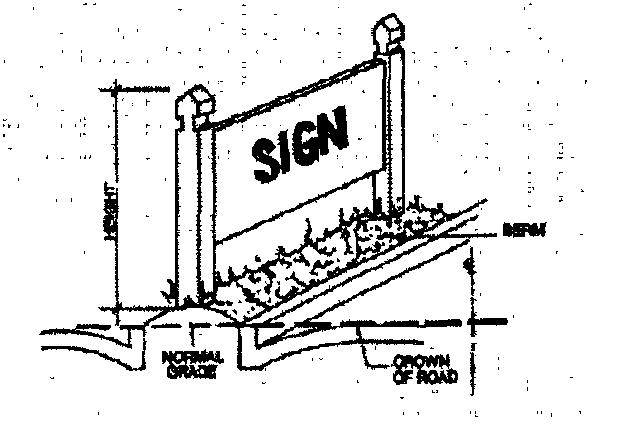
Graphics should illustrate dimensional relationships and development concepts to help explain or amplify content that is sometimes difficult for casual or non-technical users to understand. The current Planning and Zoning Code utilizes a handful of graphics, which makes for a text-rich development code. This inundation of text makes regulations dense and burdensome for the user by adding to the time needed to understand the development code’s content. The largely text-only format of the development code does not give readers much of an idea of what the City requires without diving into the details and carefully reading the text. Additionally, when graphics are provided, they are grainy and hard to understand (see Figure 4.3.2-1: Existing Sign Graphic). These shortcomings of the Planning and Zoning Code’s existing graphics only exacerbate the user’s challenging experience with the code’s regulations.
Figure 4.3.2-1: Existing Sign Graphic
4.4 Procedural Streamlining
4.4.1 Background
Development processes should be streamlined, avoiding wasteful and time-consuming processes, but should include meaningful public input. It is essential to allow citizens to voice input on projects that affect them. The modern best practice is to assign as many processes as possible to staff when a project proposal meets the development code’s standards and public hearings are not necessary.
Usually, public hearings are unnecessary when a use is subject to very clear regulations defined in the development code (leaving no room for interpretation or discretion), or where the application is the final step in multi-step approval processes where discretionary decisions have already been made. Where development has unique impacts, or impacts that are incapable of resolving completely through the standards of the development code, public hearings may be needed to give residents an opportunity to weigh in on applications that affect them.
4.4.2 Recommendation(s) and Analysis
4.4.2.1
Map each development process with a newly established common procedural format, beginning with applicability, and continuing to initiation and completeness, decision making, appeals, and the scope of approval.
By following a uniform layout for each process, the development process will become easier to follow for all code users. Each section relating to a specific process should have subsections that address the following questions as seen in Table 4.4-1: Procedural Components
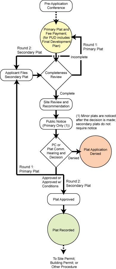
Answering the questions from Table 4.4-1: Procedural Components and incorporating graphics like Figure 4.4.2-1: Development Approval Flowchart (Valparaiso, IN) to depict contentsaturated processes are necessary features that improve code transparency, readability, and usability.
Component
Applicability
Initiation
Completeness
Notice and Hearing(s)
Decision
Standards
Subsequent Applications
Appeals
Questions the component addresses?
Who needs to go through this process?
How and to whom is an application submitted?
What is required when an application is ready to process?
What noticing requirements apply to a development application? Are there any public hearings required, and how many?
Who reviews, recommends, and makes decisions, and how?
What specific standards or criteria apply to the application?
If an applicant withdraws or is denied, can they file a new application, and when?
Who and how can an applicant appeal a decision?
Table 4.4.2-1: Procedural Components
Scope of Approval
What does this approval allow the applicant to do? What is the next step in the process?
Recordation Who records the final document and where can it be found?
Figure 4.4.2-1: Development Approval Flowchart (Valparaiso, IN)
4.4.2.2 Clearly establish the governing bodies such as the City Council, Planning and Zoning Commission, Zoning Administrator, Architectural Review Board, Historic Downtown Advisory Commission, etc., and outline each of their unique roles in the development process.
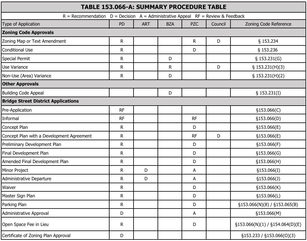
While the Planning and Zoning Code addresses who acts on each development application, the development code can be improved by providing an authority summary table (see Figure 4.4.2-1: Approval Summary (Dublin, OH)) to make it clear to the user who reviews and acts on a specific development application without sifting through each development application procedure. The common understanding is that the City staff (Zoning Administrator), Planning and Zoning Commission, and City Council play critical roles in the development process by making recommendations and approving the numerous development applications. Since these bodies are frequently involved with the development process, it is imperative that the code user knows how these bodies interact with the development process without wasting time combing through the Planning and Zoning Code’s text.
4.4.2.3 Expand staff-level approval opportunities for development applications.
Figure 4.4.2-2: Approval Summary (Dublin, OH)
The development process often takes time to navigate. Sometimes the development process does not have to take as long if the development code has clear regulations, well-defined procedures, and empowers staff to make decisions. Older development codes like Powell’s tend to produce little opportunities for staff to levy decisions on development applications because the practice is to let the Planning and Zoning Commission or City Council decide. While that may be the historical practice, it is an older one that can come with a litany of problems. The biggest potential problem is when these approval bodies have too much decision discretion. When this happens, the developer is subject to the preferences of the approval body which sometimes falls outside the bounds of the development code. To curb these instances, the development code should rely on the standards of the code but also empower staff to make decisions on nonlegislative applications. Ultimately, the Planning and Zoning Commission and the City Council should make decisions on quasi-legislative and legislative applications instead of becoming involved with every single development application. Reducing the Planning and Zoning Commission and City Council’s plate to only quasi-legislative and legislative development applications and increasing staff-level approvals will achieve four things: 1) improve staff confidence and expand their role in the development process; 2) expedite the development process; 3) ensure the development process is fair and devoid of any arbitrary conditions at the behest of the Planning and Zoning Commission/City Council; and 4) reduce taxpayer spending by not exhausting City-resources for noticing, staff reports, and unnecessary meetings. The UDC should provide opportunities for staff to approve non-legislative development applications to improve the development process.
4.4.2.4 Provide regulatory relief tools approved by staff like alternative compliance and minor modifications to alleviate code rigidity and to expedite the development process.
Like many older development codes, the City’s Planning and Zoning Code fails to do much in terms of development flexibility. Typically, in older codes, the available development relief options are variances and the PUD process. Powell’s approach is consistent with this practice. While this practice may have been practical decades ago when land availability was abundant, and development pressures were less prevalent, modern development codes tend to maximize development flexibility by establishing additional relief options. For instance, many recently adopted development codes, provide regulatory relief tools like alternative compliance, special exceptions, minor modifications, and design exceptions, to accommodate development scenarios that meet the intent of the regulations but may fail to strictly adhere to all the regulations’ requirements. Additionally, these regulatory relief options are available because the proposed development may not meet the hardship requirements typically required for a variance request. Given the Planning and Zoning Code’s limited development relief opportunities and preference for strict code adherence, the UDC should encourage development relief that produces similar development outcomes consistent with the spirit and intent of the regulations. These relief options should be clearly defined and lack arbitrary criteria to avoid abuse and misuse of the relief tool and reinforce the UDC’s intent. While such a recommendation will alleviate UDC rigidity and development inflexibility, establishing
additional regulatory relief tools should expedite and improve the development process as provided in recommendation 4.4.2.3.
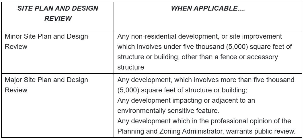
4.4.2.5 Formalize the site planning process.
Given that site planning is a critical part of the land development process, site planning procedures should be clearly understandable The City’s Planning and Zoning Code provides uncertainty about the role of the site plan in the development process. Site plans are mentioned 12 times in the Planning and Zoning Code but there is no concrete site plan criteria or actual requirements for a site plan submittal. The UDC needs to clarify if and when site plans are required, and if so, establish a clear site plan process with bonafide submittal criteria Such an example can be noted in Reynoldsburg, OH (see Figure 4.4.2-2: Reynoldsburg, OH Site Plan Applicability) where the City stratifies site plan review into two categories: major and minor
4.5 Definitions
4.5.1 Background
All understanding starts with definition, yet many development codes fail to realize this. Welldefined terms go a long way by reducing unnecessary interpretations, clarifying textual inconsistencies, and improving understanding. Development codes that lack definitions or poorly defined critical terms leave the code susceptible to unnecessary scrutiny. The Planning and Zoning Code has room for improvement when it comes to definitions. There are multiple occasions where a term should be defined but fails to provide a definition. Instances like these need to be audited and appropriately addressed to improve the code users’ experience.
Figure 4.4.2-3: Reynoldsburg, OH Site Plan Applicability
4.5.2 Recommendation(s) and Analysis
4.5.2.1 Create an exclusive title for terms, definitions, acronyms, and commonly used phrases and label that title as “Definitions”. Once created, then locate the definitions title towards the end of the UDC.
Definitions are embedded in multiple places throughout each title. This approach to definition management is dated. Modern UDCs establish definitions as its own title where terms, acronyms, and uses are provided in one location. This type of approach improves code usability by making definition easy to find. Also, while it may seem to be appropriate to have definitions at the beginning of a development code or in locations where a certain set of definitions are more applicable, it is best practice to locate all definitions towards the end of the UDC due to the number of terms and sheer length of the code’s text The UDC should place the definitions near the back to emphasize the most pertinent information upfront.
4.5.2.2 Align UDC definitions with any recent State Law changes.
Often when development codes have not been updated for a while, there are instances where definitions are inconsistent with amendments to State Law. Powell’s Planning and Zoning Code has a few instances where definitions are not adequately aligned with State Law. As such, the UDC should address these inconsistencies by aligning definitions and terminology with that of the Ohio Revised Statutes, Ohio Administrative Code, and any other State regulation which addresses development.
5 Planning and Zoning Code Topical Analysis
5.1 Zoning Districts and Dimensional Standards
5.1.1
Background
In the United States, zoning regulations establish what land uses are permitted on a given piece of land, and govern characteristics of design, construction, and spatial relationships between buildings and other structures, roads, easements, and other rights of way. By creating zoning districts, cities can promote the development of cohesive and harmonious neighborhoods, commercial centers, downtowns, employment centers, and mixed-use areas. Zoning best practices have evolved over the last century, moving from a tool to separate noxious uses such as heavy industry from residential areas to a means of separating different uses during the Post-World War II highway expansion era, to its contemporary standing as a tool to build walkable, attractive, sustainable mixed-use communities.
Zoning regulations typically include the following elements:
• Zoning Districts
Zoning divides cities into districts where various regulations apply. These can include conventional districts, overlay districts, special use districts, floating zones, and formbased zoning.
• Planned Unit Development
Planned Unit Developments (PUDs) are typically standalone districts where an applicant can deviate from the normal district standards in exchange for providing a higher level of design, amenities, or other community benefits.
• Density & Intensity
Zoning districts control the density and intensity of development by prescribing minimum lot area and dimensional requirements. Some communities also specify the minimum or maximum number of dwelling units allowed per acre of land.
• Bulk & Setbacks (Dimensional Regulations)
Zoning districts regulate the size or bulk of structures through the application of minimum or maximum setbacks (from property lines, streets, or other structures), height, floor area ratio, and lot coverage requirements.
• Uses
In each district, some uses are permitted, some are prohibited, and others are regulated through discretionary review (i.e., conditional/special use permit approval). Many uses have conditions or standards that apply whether the use is permitted or requires conditional use permit approval.
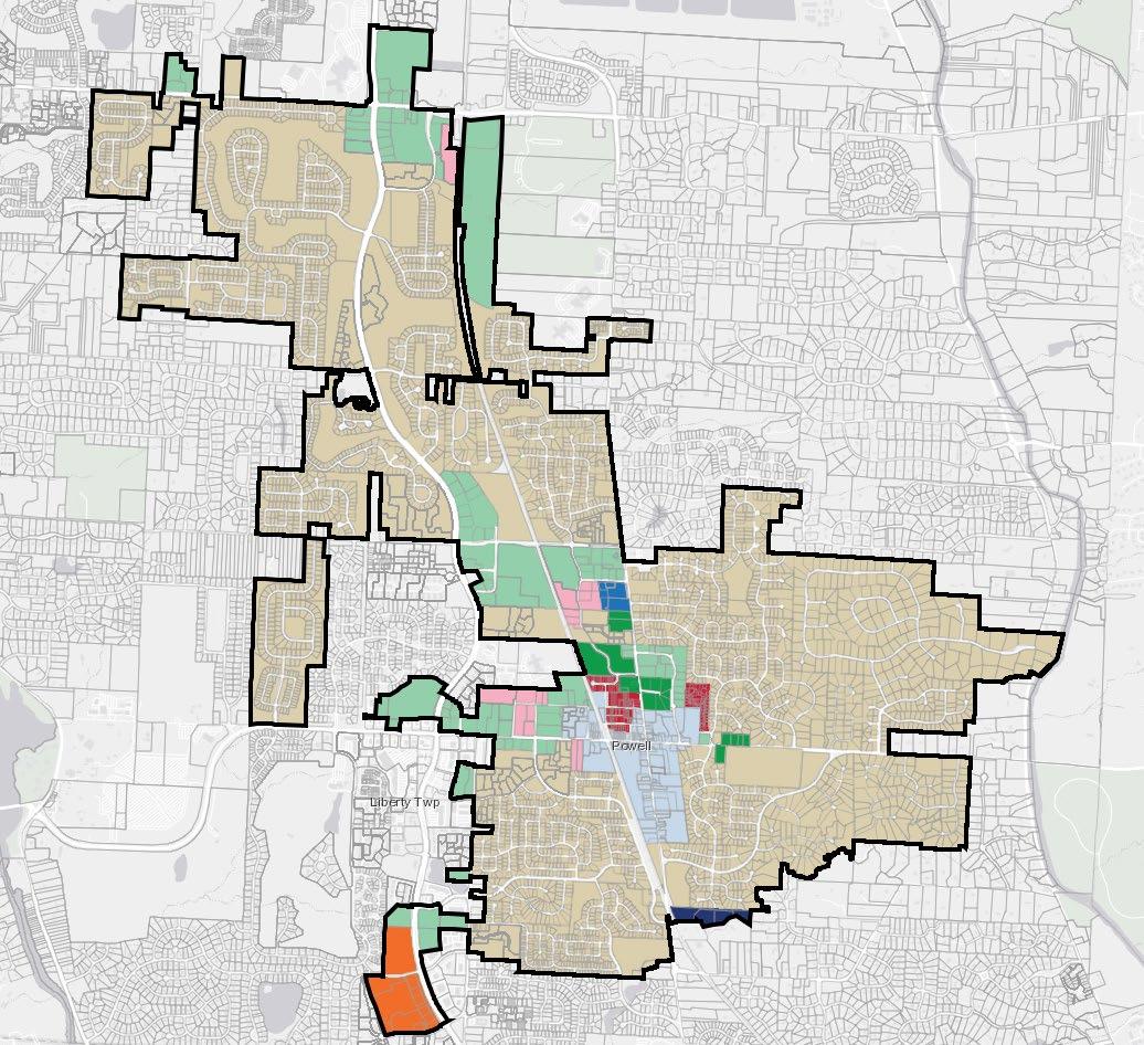
In Powell, the Planning and Zoning Code uses zoning regulations to establish 11 total zoning districts, including three overlay districts (see Table 5.1-1: Current Zoning Districts and Figure). The current base zoning district regulations have produced development outcomes the City is accustomed to
Table 5.1.1-1: Current Zoning Districts
District Category
Residential
Nonresidential
Overlay
District
Map Color
R – Residence Dark Green
DR – Downtown Residence Red
PR – Planned Residence Beige
PRC – Planned Residence
Conservation
PO – Planned Office Royal Blue
PC – Planned Commercial Light Green
PI – Planned Industrial Pink
DB – Downtown Business Light Blue
DD – Downtown District Overlay
OR – Olentangy River
Environment Overlay
AR – Architectural Review Overlay
When assessing the Zoning Map (see Figure 5.1.1-1: Powell Zoning Map), it is evident that residential zoning dominates Powell’s development landscape. Although the majority of Powell is zoned residential, there are few nonresidentially zoned areas seen in and around downtown and along some of the City’s busy roadways (Home, Seldom Seen, Sawmill, Liberty, and Powell). As the City continues to grow, redevelop, and reach buildout as envisioned in the Comprehensive Plan, zoning will play a more critical role than what it has currently.
5.1.2 Recommendation(s) and Analysis
5.1.2.1 Deviate from planned and non-planned districts by treating them as base districts.
The current Planning and Zoning Code establishes two sets of zoning districts: planned districts and those that are not. The UDC should eliminate this distinction because both sets of zoning districts act similarly. The primary distinction between the two are that the planned districts require additional submittals for approval. The original intent of the planned districts was to
Figure 5.1.1-1: Powell Zoning Map
establish parameters for new, large-scale areas of Powell, but with the rapid growth of the region, planned districts are reaching build out.
5.1.2.2 Revise and reduce the number of districts through the consolidation of similar districts.
While the current code provides four residential districts, some of those districts are seldom used. For that purpose, it is reasonable to reduce the number of residential districts by consolidation. For example, most of the City’s residential zoning is PR (Planned Residence) so it is unnecessary to have additional residential districts that achieve similar development patterns. Instead, the UDC could have two or three residential districts. While that may seem like an oversimplification to zoning consolidation that fails to consider various single-family housing contexts, it does not mean that the district cannot have additional regulations to provide residential variety. This can be addressed by establishing criteria for housing variety. However, if the City prefers to keep multiple residential districts, it will be critical to provide missing middle housing types (duplexes, triplexes, quadplexes, manor apartment buildings, etc.) in higher density residential districts.
For the nonresidential districts, consolidation should be targeted to align with best practices. Modern development codes are deviating from the conventional district classification system of office, commercial, and industrial and moving towards a more holistic, flexible classification system. For example, development codes have started combining office and commercial districts together, and in some instances, have consolidated industrial districts with office and heavy commercial districts. In Powell, the separation of office, commercial, and industrial districts is unnecessary and should gravitate towards the modern zoning model. As such, the UDC should consider consolidating the PO (Planned Office) and PC (Planned Commercial) districts into one commercial district. This consolidation is even more attainable because of office space trends. Since the Pandemic, office space demands have drastically decreased resulting in less office development Unsure of the demand for new office space given market conditions, it is reasonable to consolidate the PO and PC districts.
5.1.2.3 Rightsize, and in some instances, reduce district dimensional standards to balance best practices and existing community character.
Although Powell wants to retain its rural character and unique heritage, the zoning district standards should strike a balance between the past and present. For instance, some of the district standards are out of touch with best practices and market conditions, particularly the standards in the nonresidential districts. Specifically, the PC district dimensional standards are not conducive to contemporary development practices. Large minimum setbacks make little sense especially given the City’s preference for smaller-scale, village-type development. Minimum setbacks in these circumstances should be reduced by at least 50% to achieve such a development pattern. Large setbacks in the PC district incentivizes automobile-oriented development by allowing front-entry parking seas Opportunities like these should be carefully considered within the UDC to achieve the City’s preferred development outcomes.
5.1.2.4 Generally, retain low-density development patterns but increase density in targeted areas of town.
The Comprehensive Plan emphasizes retaining the community’s rural character and maintaining low-density development patterns. However, the Comprehensive Plan seeks targeted development of denser, mixed-use areas in certain locations. The UDC should continue providing zoning districts that retain the City’s preference for low-density development but also strengthen nonresidential zoning district standards to allow for more and improved mixed-use development in specific locations Districts with context-sensitive intricacies like the DB and DD Overlay should be carried forward but applied to other areas of the city where mixed-use development is preferred.
5.1.2.5 Expand existing density bonuses to facilitate development patterns as envisioned in the Comprehensive Plan.
While the Planning and Zoning Code provides density bonuses, it only does so subtly. In the PR district, a base gross density bonus of 0.70 du/gross acre can apply depending on street classification, public land dedication/reservation, and the fiscal impact of the project. This bonus does little to achieve increased density. The UDC should build on this approach but calibrate the density bonus somewhere to the scale of 1-4 du/gross acre.
5.1.2.6 Retain transfer of development rights (TDR) options but expand the scope of TDR to other zoning districts.
The Planning and Zoning Code is progressive in that TDR is an option to retain the City’s rural character while allowing denser development in other higher-intensity areas. The UDC should expand on the existing TDR standards and allow transfers to occur to targeted mixed-use areas. Modifying the TDR regulations could facilitate and incentivize mixed-use development.
5.1.2.7 Refrain from regulating residential minimum floor area (rely on IRC and IBC standards).
Most of the Planning and Zoning Code’s zoning districts maintain certain minimum floor area requirements. While the intent of these regulations may be well-intentioned to ensure appropriate living spaces, these types of requirements should be removed from the UDC due to litigation risks. Currently, in Georgia there is litigation challenging a city’s ability to regulate residence size. The case has not been heard yet, but nonetheless, the issue has been raised and something jurisdictions should steer clear from to avoid legal exposure. Instead, the UDC should remove residential minimum floor area requirements and rely on IRC and IBC standards.
5.1.2.8 Opt to let the market regulate density instead of mandating density maximums in the UDC.
5.1.2.9
Although regulating density is a common practice, it is one that is becoming increasingly outdated. Density has always been a topic of concern for many suburban and rural communities, but data shows the lower the development density, the more strain a community places on its infrastructure system and greater tax burden placed on its residents. To offset this situation, communities with modern development codes are starting to increase density. While communities are increasing density some are doing so by relying on the market. Because of the mix of high land prices, homebuyer purchasing power constraints, steep interest rates, building material costs, and inflation, developers are reluctant to build conventional, larger lot singlefamily homes because the numbers do not work. As a result, home lot sizes have decreased while density has increased to return a positive return on investment. Instead of requiring certain densities that are hard to manage, the UDC should still emphasize low-density, singlefamily development but let the market decide the appropriate density.
Provide the following changes to the DR district:
a) Remove lot size minimum requirements and include lot size maximums.
Requiring maximum lot sizes and limiting lot consolidations can curb the development of largescale residences that do not meet the desired village residential scale, form, and density.
b) Remove unit size minimums.
As previously mentioned, removing residential minimum floor area requirements should be strongly encouraged. In this instance, removing this standard will allow for flexibility in housing options and choices in the only walkable village development pattern within Powell.
c) Allow townhouses and duplexes in all areas of Downtown but cap the number of attached townhouses at groups of no more than five.
Downtowns typically have multiple housing options available for both renters and owners ranging from vertical mixed-use apartment buildings to multi-story brownstones. Powell should continue providing other housing options like townhouses and plexes that are consistent with Downtown development practices. However, there should be additional regulations, like endcapping townhouses to five in a row and only allowing stacked, multi-story rear-entry duplexes, to help retain Downtown’s character.
d) Expand accessory dwelling unit (ADU) options in Downtown.
Accessory dwelling units are a consistent element of Downtown residential areas. The UDC should allow for ADUs either attached to or detached from the principal structure in all areas of downtown to continue with village residential development patterns. However, ADU-specific standards need to be robust and be compatible with the form and scale of Downtown.
e) Require rather than suggesting that all parking areas or garages enter from rear alleys or drive aisles leading from the principal street to rear yard parking or garages.
5.1.2.10
The Planning and Zoning Code does not require rear entry parking but encourages it. The UDC should specify rear entry parking arrangements in the DR district to align with traditional village residential development patterns. Requiring rear entry parking will protect the traditional village context by prohibiting front-loaded garages and additional front yard pavement.
Provide the following changes to the DB district:
a) Eliminate the need for setbacks and allow for zero lot line development.
Setbacks are typically necessary for suburban greenfield development but not so much in walkable developments. To achieve walkability and the appropriate pedestrian-scale, setbacks, particularly minimum front setbacks as well as side setbacks, in the DB district should be eliminated. Such a change would allow for development to front the right-of-way and encourage zero lot line development where arbitrary side setbacks are no longer necessary. However, setbacks can serve a critical purpose for walkable developments if regulated intentionally Maximum setbacks or a setback range could be suggested to ensure buildings are situated near the right-of-way to protect the form of the development
b) Include some form and scale standards for the development of multi-family housing.
Walkable, mixed-use areas often do not work if housing variety and density are not appropriately accommodated Such accommodation means adequately addressing the form and scale of buildings, particularly multi-family buildings. Often times in suburban communities, multi-family housing carries a negative connotation because of renter bias, density, and safety concerns, but in many cases, communities prefer to see a certain style of multi-family housing. In the DB district, multi-family housing should be compatible with the character of the area. Large low-rise garden-style apartments do not fit the character of the area and should be discouraged. Instead, other forms of smaller-scale multi-family housing units like courtyard apartments or apartment lofts may better suit the area.
c) Allow for maximum lot coverage more than 50% to ensure a denser and more walkable development pattern and to discourage surface parking.
One of the biggest inhibitors to densifying development are lot coverage requirements. Low maximum lot coverage requirements can result in sprawling development because it prevents the lot from being fully developed. Ultimately, in dense contexts, such requirements are unsuitable for denser areas. Maximum lot coverage should exceed 50% to achieve density and the appropriate character. While intense urban environments typically have high or even no maximum lot coverage requirements, Powell’s approach should not reach that level. Instead, the UDC should consider the scale of the area and allow for maximum lot coverage requirements between the 50-85% range.
d) Create off-street parking minimums specific to certain uses in the context of Downtown.
If minimum parking ratios are provided, they should always be done so with context-sensitivity. Given that Powell has suburban-style development, it makes sense to have higher minimum parking ratios in those areas. However, in an environment where walkability is highly sought, parking ratios may need to be further calibrated. In the DB district, certain uses should have lower parking ratios while others have higher ones The lowest ratio possible should be used to ensure adequate on-site parking for small-scale uses to avoid overcrowding of on-street parking. For example, restaurants should have higher required minimum off-street parking than a retail boutique or small professional office. The UDC should keep this type of context-sensitivity at the forefront of district-specific regulations to ensure areas like Downtown maintain its traditional development character.
5.1.2.11 Provide the following changes the DD overlay district (if retaining) as related to the DR and DB districts:
a) Combine the DR, DB, and DD overlay districts into a new DV – Downtown Village District. that allows a mix of the uses permitted in the DR and DB districts in all areas of downtown with exceptions for certain streets where commercial uses are not desired.
As previously mentioned, district consolidation should be considered. In the case of the DR, DB, and DD (overlay) districts, a new district called the Downtown Village (DV) district, combining the three should be established. The DV district should be rightsized to fit the various residential and mixed-use subareas of the Downtown area. The district would provide multiple subareas to facilitate the preferred development outcomes. For example, one subarea could be the residential one and the other the mixed-use subarea. Within those subareas a mix of uses would be carefully calibrated to accomplish the subarea’s intent. Additionally, with the subarea approach development can be further calibrated by street to prevent certain uses along specific streets. For instance, development along Powell Road could be restricted to commercial uses while N Liberty Street could allow for commercial and residential uses.
b) Refine and recalibrate use allowances for both residential and commercial uses in the Downtown area. Eliminate single unit uses as a use in the downtown area.
Use allowances must make sense, especially when character and compatibility are critical to an area’s fabric. As mentioned later in this report, uses have to be specifically tailored for the subareas of Downtown. Uses like retail storefronts, boutique hotels, and cozy restaurants, are typical to Downtown.
c) Refine and recalibrate the development standards for all uses in the downtown area to promote reasonable additional density and walkable form.
Downtowns usually thrive on increased density and walkability. Powell’s Downtown should be no different. While Powell’s Downtown may not be as dense as Columbus, a baseline density should be maintained to retain the area’s vibrancy. Development standards like parking,
landscaping, and signage play a critical role for pedestrian-friendly downtowns. Such standards should bring the building to the street as close as possible, prohibit front-loaded parking facilities, and allow various pedestrian-sized signs conducive to a vibrant mixed use area.
d) Combine the planned development review and certificate of appropriateness processes for efficiency and removal of redundancies.
If the City prefers to retain the planned development review and certificate of appropriateness processes, then the UDC should find ways to streamline the development process and reduce procedural inefficiencies. For instance, instead of two separate processes for planned development review and certificate of appropriateness, the UDC could combine the two processes into one.
e) Implement the City’s policy for historic properties in Downtown after the conclusion of the historic property survey.
The City is currently conducting a historic property survey Downtown to form a holistic view of which buildings are significant. Once properties have been identified as significant, then the UDC needs to appropriately address the redevelopment of those properties of significance. The survey should help the UDC clarify the Downtown development process and retain transparency by informing which bodies (Planning and Zoning Commission, Historic Downtown Advisory Commission, staff, etc.) make recommendations and approval decisions pertaining to renovations, alterations, and development of historically significant properties Additionally, the survey should guide the decision-making criteria for those bodies in the UDC.
f) Introduce more specific design standards to provide more certainty to the reviewing agency or tribunal on making determinations of appropriateness.
While there are Downtown design guidelines, these guidelines need to be strengthened and codified to avoid arbitrary determinations of appropriateness. The standards should not be so strict that development becomes difficult, instead, a baseline standard of what is acceptable should be provided. Additional standards to increase the development aesthetic should be enhancement features and considered when determining appropriateness
5.1.2.12 Remove restrictions limiting the number of principal buildings per lot requirement.
Zoning restrictions that limit the number of principal buildings per lot can be problematic when faced with housing and development strains. Such a requirement limits development potential and places barriers to certain types of development. For example, an apartment complex cannot be built on one lot due to this restriction which is impractical given contemporary apartment development practices. Also, multiple homes of equal size are not allowed on a lot even if it’s a large acreage lot and shared by one family. This type of living situation is common with historical villages and exurban communities and should not be illegal because of restrictive regulations The UDC should remove this restriction and allow for multiple principal buildings on lot to align with modern development practices and regulatory approaches.
However, if Powell aspires to retain this standard, at the minimum, specific exceptions should be considered to facilitate development instead of limiting it.
5.1.2.13 Create more flexibility and context sensitivity in sight triangle requirements.
Sight triangle requirements are an important and often overlooked aspect of a community’s development standards. While the City has a standard to ensure visibility is protected, sometimes these standards need to be rightsized because development conditions vary. For instance, it may be more necessary to require a larger sight triangle at the intersection of two arterial streets as opposed to requiring that same sight triangle at the intersection of two local streets. While it is important to provide various sight triangle contexts, it is equally critical to define sight triangles appropriately. Sight triangles should be defined in such a way that explicitly prevents obstructions like signs, buildings, driveways, trees, light poles, fences, and utilities to avoid traffic conflicts.
5.2 Uses
5.2.1 Background
The appropriate identification, definition, and understanding of land use is the foundational piece as to why zoning exists. Without uses, development patterns may become disjointed particularly for Euclidean zoning approaches. If there are no identified uses, zoning would be irrelevant because any land use activity would be allowed. In sum, uses are critical to the UDC because it implements a zoning district’s intent and establishes development activity allowances.
5.2.2 Recommendation(s) and Analysis
5.2.2.1 Create a singular Use Title that encompasses the use table, including specific, accessory, and temporary uses, and references to use-specific standards.
Unlike most modern codes, the current Planning and Zoning Code does not provide a title solely focused on uses. This title should house the use table, use-specific standards, and accessory and temporary uses to improve code usability. In the current code, uses and use-related regulations are sporadically placed. This sporadic placement adds unnecessary time for the user because they must look up the allowed use in the district regulations, find the definition of that use, and finally check if any additional standards apply to that use. A UDC with its own use title will eliminate this unwarranted process by placing all pertinent use information in one location.
5.2.2.2 Eliminate prescriptive use allowances by zoning district and establish a Use Table.
The current Planning and Zoning Code provides use allowances for each zoning district at the beginning of the district’s section. While the use allowances are clearly identified, the current approach is rather outdated. Previously, development codes listed all the permitted uses in each district, which would lead to missing use allowances in other districts. Best practices have evolved by establishing a Use Table that lists all uses and assigns allowances by zoning
district in one location. This type of best practice is becoming increasingly prevalent in Central Ohio as seen in the City of Gahanna in Figure 5.2.2-1: Use Table Excerpt (Gahanna, OH). Powell should follow a similar approach to Gahanna’s and allocate uses in a comprehensive, succinct, and understandable manner.
5.2.2-1:
OH)
5.2.2.3
Create context-sensitive use-specific standards that are tailored appropriately for specific zoning districts.
Although the current Planning and Zoning Code provides some use-specific standards in Chapter 1147 (Special Regulations), there is room to improve the function of certain uses in specific zoning districts. Most modern development codes expand on use-specific standards to ensure a particular use adequately fits the zoning district’s character and intent. For example, a retail store could be allowed in all commercial zoning districts with the use-specific standards regulating the size, location, and form of that use for each district (see Table 5.2-1: Sample UseSpecific Standards by District). These additional regulations can protect districts from improperly scaled development and promote land use compatibility, thus generating the best product that aligns with a particular district’s intent.
Table 5.2.2-1: Sample Use-Specific Standards by District
Figure
Use Table Excerpt (Gahanna,
Location from single-family
Front-entry parking allowed
parking allowed
Drive-thru Facilities
5.2.2.4 Reduce the number of uses that require conditional use and special use permits by implementing use-specific standards.
While it is typical to allow uses by-right and by conditional or special use permit, it is generally a best practice to reduce the need for conditional and special use permit approval as much as possible. This means more room for uncertainty since the Planning and Zoning Commission uses their discretion to decide whether the use should be allowed in a district. As an alternative to the overuse of conditional/special use permits, the UDC should find ways to reduce conditional/special use permits by implementing use-specific standards where necessary. As previously mentioned, these standards are helpful for regulating development scale and land use compatibility without Planning and Zoning Commission intervention.
5.2.2.5 Clearly distinguish the difference between special use permits and conditional use permits by establishing a clearer use allowance system.
The Planning and Zoning Code provides instances where special use permits and conditional use permits are required. To say the least, these distinctions are confusing since they are not adequately defined, nor are there clear processes establishing the two permits. Use allocations and their associated regulations should not be as convoluted as it is in the Planning and Zoning Code. Although the previous recommendations address creating a use table, clarifying uses via specific use regulations, and maintaining a comprehensive use title, this recommendation focuses on distinguishing the by-right, conditional, and special use allowances through a clear method. To ease the confusion with use allowances, the UDC should establish a system that identifies permitted uses by-right, by limited use, and as conditional uses. For instance, Raleigh uses this approach to clearly communicate to the user the allowance difference and what that means in the development process. In the use table, there are P’s, L’s, and S’s which indicate if a use is allowed by-right (P) by staff, as a limited use (L) by staff, or as specific use (S) by quasilegislative approval. P’s do not have use-specific regulations whereas L’s do. Essentially, L’s are allowed by-right with the stipulation that use-specific regulations are met. Where an S exists, additional use-specific regulations may apply but such a use requires review and approval by a quasi-legislative body. The system Raleigh uses is not only modern but easy to understand from a code users’ perspective. The Powell UDC should consider implementing this type of use allowance system to improve clarity particularly when navigating use regulations.
5.2.2.6 Expand the housing typology.
One of the most vital sets of land uses are those related to housing. Recently, housing has become increasingly relevant in national planning efforts. Housing, particularly in urban fringe communities like Powell, tend to have limited housing diversity and should aim to expand those options to accommodate the different needs of residents. The UDC should act on this approach by establishing new housing types at various densities to fill in missing housing gaps. Housing uses like triplexes, multiplexes, cottage courts, and courtyard apartments should be provided in the UDC and allowed in zoning districts where density is encouraged or preferred.
5.2.2.7 Deviate from preferential housing choices which could potentially violate the Fair Housing Act.
The Planning and Zoning Code provides some unique housing options available to Powell residents. While its meaningful to address elderly housing, the UDC should refrain from specifically calling out accessory elderly dwelling unit due to fairness concerns about other types of accessory dwelling units. At the end of the day, an accessory elderly dwelling unit is simply an accessory dwelling unit, so why is there this distinction? The UDC should refrain from these types of semantics but instead regulate accessory dwelling units fairly and consistently across the board. Eliminating this distinction will alleviate any perceived barriers to accessory dwelling unit development overall.
5.2.2.8 Continue to provide attainably priced housing options but use holistic measures to achieve affordability.
Many communities discuss housing costs but often face implementation challenges. In some instances, communities provide attainable housing options but do so with area median income (AMI) metrics. In Loudoun, there are provisions to assist people of moderate incomes (incomes between 30% and 70% AMI) find affordable housing solutions. Under this model, certain new developments provide a percentage of housing units to accommodate people at these income thresholds. While it appears affordable housing options are required, they are not. Affordable housing options are allowed through an incentive-based approach that allows additional
Figure 5.2.2-2: Use Table (Raleigh, NC)
density. The UDC should continue with housing affordability options but should use more holistic measures like AMI thresholds and proximity to public services to encourage such housing types
5.2.2.9 Define all land uses.
Every land use mentioned in the Planning and Zoning Code needs to be defined. There are some instances where a land use is provided, however, the definition is missing. The UDC needs to scrub for these instances, define all land uses, and include those uses in the Use Table.
5.3 Parking and Loading
5.3.1 Background
Minimum parking requirements were historically designed to reduce street congestion and to avoid spillover parking in residential neighborhoods. Parking regulations establish a minimum number of parking spaces for new development, typically tied to land use. They usually spell out the geometric design of parking spaces and bays, along with required surfacing. The Planning and Zoning Code currently provides requirements.
5.3.2
Recommendation(s) and Analysis
5.3.2.1 Reduce minimum parking requirements.
While developments need parking to accommodate customers and community members, overparking should be avoided. Overparking can disrupt land use patterns, increase the urban heat island effect, negatively impact stormwater drainage basins, add extra costs to development, and promote greater reliance on the automobile. In modern development codes, conventional parking metrics like parking minimums can be reduced or replaced with (or supplemented by) parking maximums. Generally, the UDC should reduce minimum parking requirements by 50% to align with best practices.
5.3.2.2 Right-size parking regulations by identifying different parking ratios and matching them within certain development contexts.
Most modern development codes do not use a one-size-fits-all parking approach because it promotes overparking and automobile reliance. Instead, the City should reduce parking ratios in higher density, mixed use areas for certain uses to achieve a more pedestrian-friendly environment. This means the City will implement a right-sized parking approach that ties together development context, neighborhood character, and the goals of the City’s long-range planning policies to deliver on pedestrian-friendly mixed-use development. For instance, in a conventional commercial district it may still be suitable to provide more parking since the automobile is the primary mode of transportation, whereas in a mixed-use district, its more attenable to provide less parking and use other parking management techniques to achieve a vibrant, walkable mixed use area.
5.3.2.3 Assign parking ratios to every listed land use as provided in the Use Table.
While the Use Table provides all the listed uses in the UDC, it also should house the required parking ratios. In the Planning and Zoning Code, some of the parking ratios are missing or the use listed in the parking section is inconsistent with the use provided in the zoning district standards. For example, the Planned Industrial district allows for “service and repair facilities” and “auto service stations” but the parking space requirements in 1149.07 lists parking ratios for “motor vehicle repair station” and “motor vehicle service station”. Also, in the parking section, “consumer and trade service” uses have a specific ratio, but this use classification is not provided in the zoning district standards. These types of use inconsistencies need to be addressed and align with one another when parking ratios are provided, and the simplest way to fix that is by including the required parking ratio alongside the use in the Use Table.
5.3.2.4 Use fixed parking ratio variables, like building square footage, site acreage, etc., to eliminate fluctuating required parking rates.
The Planning and Zoning Code currently assigns parking ratios dependent on multiple variables. There are over ten different variables the City uses to determine required parking. Some of those are unfixed variables like employees, washing machines, and dining room seats. While this may not seem problematic, it is because at any given moment employees, washing machines, and dining room seats can fluctuate. In Powell, a drive-in restaurant requires one space for every 125 square feet of floor area plus one space for every two employees. In the restaurant industry, shifts change and require fluctuations in staffing depending on the flow of business. So if a restaurant has 10 employees working a breakfast shift, 15 working the lunch shift, and 20 working the dinner shift on the same day then the required parking ratio changes three times. Determining parking with these types of variables create more problems, which champions that parking ratios be assigned to fixed variables like floor area to generate the fairest parking ratios.
5.3.2.5 Provide context-sensitive parking adjustments and reductions to prevent excessive parking.
Excessive parking has been a constant development theme over the past decade, and while reducing parking minimums may be a start, sometimes it is not enough to curb overparking. Communities can provide parking adjustments or reductions to further mitigate overparking. For example, in Loudoun County, VA and Valparaiso, IN there are multiple ways to reduce parking. One can do so, particularly in Downtown and mixed-use areas, is by using shared parking ratios, public parking lot and on-street parking credits, and constructing structured parking facilities. Powell should consider these types of parking adjustments and encourage other ways to control overparking aside from lowered minimum parking ratios.
5.3.2.6 Retain rear and side-loaded off-street parking standards particularly in Downtown and mixed-use areas.
The current Planning and Zoning Code does a good job of addressing parking in Downtown and should continue requiring rear and side-loaded parking. This type of parking practice ensures parking does not detract from Downtown’s character while still providing access to the
numerous shops and restaurants. Rear and side-loaded parking is not mutually exclusive to Powell, but a practice noticed throughout Central Ohio like Dublin.
5.3.2.7 Implement bicycle parking requirements applicable to certain development contexts like downtown and mixed-use areas.
Although parking regulations tend to focus on vehicle accommodations, parking standards should be expanded to include other modes of transportation such as cycling. Bicycle parking should be prioritized particularly in areas like downtowns and mixed-use nodes where pedestrian-oriented development is preferred. While bicycle parking should be accommodated, it should be done so in practical manners as seen in Loudoun County, VA; Edmond, OK; and Valparaiso, IN. In these communities bicycle parking standards are provided and assigned contextually throughout the jurisdiction. For instance, in Loudoun County, there are five development contexts: urban, suburban, transition, rural, and joint land management areas. Vehicular parking requirements apply to each development context, but bicycle parking is only required for development in urban and suburban contexts (see Figure 5.3.2-1: Bicycle Parking Ratios Excerpt (Loudoun County, VA)). Powell should follow a similar approach to expanding parking regulations to bicycle facilities to encourage multimodal transportation and pedestrian-oriented development in some of the City’s premier locations like Downtown.
Additionally, while bicycle ratios should be provided, the UDC should also implement robust standards and specifications to ensure that bicycle parking is not only provided but
Figure 5.3.2-1: Bicycle Parking Ratios Excerpt (Loudoun County, VA)
accommodated in an aesthetically appealing manner. Valparaiso and Knoxville are examples where there are clear standards for bicycle parking and its associated facilities.
5.3.2.8 Adjust minimum loading requirements from 3,000 square feet to 10,000 square feet of gross floor area.
The requirement threshold for loading should be increased from 3,000 to 10,000 square feet to ensure loading is needed on-site. Typically, buildings less than 5,000 square feet generate less loading needs, unless it’s a restaurant It may be in the best interest of the City to reduce unnecessary pavement such as loading areas if there is not a significant demand for loading facilities.
5.3.2.9 Rightsize loading space requirements.
Loading demand is not the same for every development. Some developments like industrial parks might require intensive loading facilities whereas a suburban office complex might require substantially less loading. While industrial parks and suburban office complexes are clearly not the same, loading will most certainly be needed on-site. In the industrial park, loading facilities should probably accommodate large delivery trucks like semi-trailer trucks while the office complex should suit smaller delivery vehicles like cargo vans and box trucks. Some communities in Central Ohio realize the variety of loading needs and have provided regulations that address those needs. For example, Marysville provides two loading types and allocates the loading types by land use group and gross floor area (see Figure 5.3.2-2: Loading Requirements Excerpt (Marysville, OH)). Type A loading is reserved for semi-trailer trucks, requiring a 14-foot wide by 55-foot long by 15-foot tall (clearance height) space. Meanwhile Type B loading accounts for smaller service vehicles, requiring a 12-foot wide by 30-foot long by 15-foot tall (clearance height) space Powell should consider an approach like Marysville’s where the UDC accounts for various loading needs by establishing rightsized loading facilities according to land use group, gross floor area, and the anticipated type of delivery trucks onsite.
5.3.2.10 Expand loading options in mixed-use areas.
On-site loading facilities are often overlooked components of the development process. In most instances, loading facilities consume much needed usable space. Loading facilities should not be required for all development but instead a context-sensitive approach should be considered. As an example, on-street loading may be allowed during non-peak hours but prohibited during peak hours for a development in Downtown. The UDC should continue emphasizing context-sensitive regulations to appropriately address the City’s preferred development patterns.
5.3.2.11 Prohibit on-lawn vehicular parking.
While the Planning and Zoning Code prohibits lawn parking, it does not always do so. For example, lawn parking can occur as long as the vehicle is not parked on a lawn for more than 24 hours. That means a residential lot can have parked vehicles in the front yard overnight as long as the car is moved in the morning. The current regulation needs to be expanded and prohibit lawn parking at any time, particularly in residential areas If lawn parking should be needed, then the City should require a special permit in those instances.
5.4 Landscaping
5.4.1 Background
Most modern development codes have landscaping standards to mitigate environmental site conditions, reduce heat island effects, minimize conflicts between incompatible uses, and soften the visual impacts of parking areas and intensive uses. Landscaping adds to development costs both upfront and over time through maintenance and irrigation, although long-term savings from
stormwater management and energy savings through shading of building and parking areas can offset some of these costs.
5.4.2 Recommendation(s) and Analysis
5.4.2.1 Provide more robust landscaping standards that adequately capture the various context in Powell.
The Planning and Zoning Code provides some solid landscaping standards. The current regulations could benefit from an expanded and flexible regulatory approach Landscaping regulations should be strengthened to allow for more context sensitivity by specifying additional instances in which alternative methods or varying landscaping arrangements may be suitable. Additionally, to improve context sensitivity, a points-based regulatory framework could be explored. The UDC could establish a points-based system where the developer chooses from a menu of landscaping elements to provide sufficient on-site landscaping. For instance, the UDC could require varying landscaping points for different buffer strip widths, the number of trees on-site, the size and spacing of those trees, use of shrubs, implementation of native plant materials and xeriscaping techniques. For example, Oklahoma City utilizes a points-based landscaping system where points are calculated by the number of site points, parking lot points, and frontage tree requirements applicable to zoning district in which those points determine the percentages and location of plantings, quantity, type, and size of plant materials needed on site. While Oklahoma City is a completely different makeup than Powell, this type of flexible landscaping approach is something that could be implemented in Powell to avoid rigid landscaping standards that fail to accommodate the City’s various contexts
5.5 Signs
5.5.1
Background
Signs are a pervasive element of the built environment. Signs serve important purposes, such as identifying places of business or institutions, directing traffic, and expressing opinions. Businesses rely on signs to create a street presence and to generate sales from motorists or pedestrians who might not otherwise become aware of their presence. Politicians and activists rely on signs to get the word out about their campaigns or matters of public interest. Institutions (such as churches and schools) use signs to announce events, speakers, and inspirational messages. Some signs can also have a negative impact on the public. Signs are often identified with clutter along roadway corridors, driver distraction, and when not properly maintained blighting influences. Excessively bright signs can disrupt the quiet enjoyment of residential neighborhoods or distract drivers (while, at the same time, making those signs more visible to motorists). Sign regulations should avoid potential negative impacts, while enabling freedom of expression and commerce.
Among other things, sign regulations typically establish:
• Sign categories such as wall and freestanding signs,
• Locations where the sign types are permitted,
• Dimensional standards (i.e., maximum size and height, minimum setbacks),
• Maximum number of signs allowed,
• Design features such as illumination, materials, and use of LED technology, and
• Whether sign permits are required.
5.5.2 Recommendation(s) and Analysis
5.5.2.1 Consider expanding sign standards to be less restrictive.
The current Planning and Zoning Code sign regulations are fairly restrictive leaving little opportunity to provide unique signs. There are instances where the regulations restrict the number of fonts, the amount of characters, and how many colors a sign can use. This is too burdensome for modern sign regulations, and regulatory overreach. The UDC should loosen these restrictions and allow for greater freedom of expression.
5.5.2.2 Continue regulating signs in a manner that protects constitutional principles.
Overall, the Planning and Zoning Code does a good job of protecting constitutional principles guaranteed by the 1st and 14th Amendments. However, there are occasional lapses where constitutional principles need to be revised. For instance, “permanent subdivision identification signs” should be tweaked to better align with 1st Amendment liberties because the sign type regulates the content of the sign The UDC needs to clean up these content-based restrictions and strengthen constitutional principles by ensuring sign standards only regulate the time, manner, and place of signs.
5.5.2.3 Correct inconsistencies between sign types.
The Planning and Zoning Code has some occasional inconsistencies with its various sign types One of those inconsistencies is the distinction between portable signs and sidewalk signs. Both are the same sign product but referred to differently throughout the sign section. The references of these sign types makes it difficult for the reader to understand the difference between the two and the applicable standards. The UDC should clean up these instances and provide sign types an d regulations that are consistently referenced appropriately.
5.5.2.4 Find practical and fair ways to regulate signs on nonresidential properties in residential zoning districts (i.e., churches and schools in residential districts).
The current Planning and Zoning Code stays silent on regulating circumstances where a nonresidential use may exist on a residentially zoned parcel. While instances like these may be infrequent throughout the city limits, they do happen, particularly in residentially zoned areas with institutional uses (schools, churches, etc.). Because the Planning and Zoning Code does not adequately address sign regulations in these circumstances, it is hard to know the appropriate sign requirements that apply. The UDC should clarify sign regulations in these instances, and ensure regulations are fair and reflective of constitutional protections.
5.5.2.5 Remove sign color restrictions.
The Planning and Zoning Code limits the number of colors a sign may incorporate. The regulation mandates that no more than five colors are allowed, however, this requirement needs to be removed to avoid legal exposure citing 1st and 14th Amendment principles. For example, what if a business owner wanted to provide a sign symbolizing the color scheme of the LGBTQ flag. If the sign is prohibited because of the color criteria then it’s a fair decision per the application of the regulations but struggles to meet constitutional requirements. The business owner could argue that the regulation violates the 1st and 14th Amendments citing infringement upon freedom of expression and equal protection, respectively. As such, the UDC should avoid these possible risks and eliminate the color restriction requirement.
5.5.2.6 Allow changeable copies on sidewalk/portable signs.
Not all changeable copies are the same. Sidewalk/portable signs are important features of bustling downtowns and mixed-use areas and to highlight the vibrancy of the area. While changeable copies on signs are sometimes unfavorable, sidewalk/portable signs in pedestrianfriendly areas should allow for changeable copies. Downtown storefronts often promote specials and sales so these businesses should be allowed to do so if the sign is not of a disproportionate size allowed in the area. The UDC should allow for such signs to encourage Downtown vibrancy through signage.
5.5.2.7 Simplify the sign size measurements.
The wall sign size allowances should be simplified because there is additional information that is unnecessary. For wall signs, “the total area shall not exceed one square foot per one lineal foot of the length of the wall on which the sign is to be attached up to a maximum of 36 square feet”. This is a convoluted way to say the maximum sign size is 36 square feet. All the language in the former part of that sentence should be omitted to improve clarity and limit interpretation issues. The UDC should be mindful of instances like these and provide standards that are clear and straightforward
5.6 Screening and Fencing
5.6.1 Background
Screening is a focal development standard for modern development codes. Screening typically uses a physical barrier or landscape elements to restrict viewing capabilities and shield neighboring properties from unsightly, incompatible, or intensive development impacts. Good screening regulations can make noticeable differences in development outcomes, while poor screening standards can result in cluttered, noisy, and unattractive development patterns. Additionally, fence regulations play a critical role in the development process in communities like Powell where single-family residences dominate the development landscape. Fences act as privacy barriers between residences and security measures for industrial and institutional development. Typical fence materials include wood, metal, and vinyl. While screening and fencing both provide barriers between properties and land uses, they differ in material, purpose, and application.
5.6.2 Recommendation(s) and Analysis
5.6.2.1 Strengthen screening standards by providing visual examples to show the different screen types.
One way to clarify any uncertainty with screening standards is to provide visual aids that clearly depicts the acceptable screen types. The current Planning and Zoning Code lacks these types of visuals and relies on descriptive language to communicate the various screen types. The UDC should fill in gaps in the regulations where visual examples can improve clarity and usability as exemplified in the Covington (KY) Neighborhood Development Code (see Figure 5.6.2-1: Screening Types (Covington, KY)).
5.6.2-1: Screening Types (Covington, KY)
5.6.2.2 Provide a screening matrix that indicates the screening type, design specifications, and how a screen type applies in different development contexts.
Although the screening standards are straightforward, the requirements could be better communicated to the reader. Instead of requiring the reader to scour through sentences of regulations, the UDC should reduce these sentences by providing the relevant content into a master screening matrix that indicates the permissible screening type, when a particular screen type is required, and the specifications of that screen type. Examples of these types of matrices can be seen throughout the Rust Belt region in Valparaiso and Covington (see Figure 5.6.2-2: Screening Matrix (Valparaiso, IN)).
Figure
5.6.2.3 Require evergreen (year-round) plant materials for any proposed vegetative screen.
The current Planning and Zoning Code encourages the use of year-round plant materials instead of requiring them. For any required vegetative screening, year-round plant materials should be used to ensure a continuous screening effect. Vegetative screens that do not use evergreen plant materials are susceptible to missing gaps within the screen, so it is essentially vegetative screening provides coverage year-round
5.6.2.4 Clearly distinguish screening and fencing.
This is a general best practice but has particular salience to help improve outcomes in terms of screening and fencing. Generally, screening buffers less intensive uses from more intensive uses whereas fencing provides for privacy/security between residential uses. For example, screening via a masonry wall, wrought iron fence with shrubs, landscaping elements, or combination of those items typically applies for a commercial business that abuts a singlefamily residential subdivision. The goal for screening in this situation is to alleviate some of the ongoing activities generated from commercial businesses. On the other hand, a typical fencing situation occurs when multiple single-family residences want privacy along their shared lot
Figure 5.6.2-2: Screening Matrix (Valparaiso, IN)
lines. Usually in those instances, a wood fence is provided to maintain privacy. It is imperative that the UDC acknowledges the difference between screening and fencing and provides clear regulations that accurately depict the two.
5.7 Subdivision Design Standards
5.7.1 Background
Subdivision design standards are essential for the development process because they establish procedures and standards for dividing raw land into subdivisions. These standards typically include lots, blocks, easements, infrastructure, flood protection, and platting requirements. Regulations that are cohesive, detailed, and rightsized is the DNA for a city’s preferred development outcomes. Without relevant and detailed subdivision standards, cities would face numerous challenges that affect development. Issues related to rights-of-way, public utilities, connectivity, and open space, are all addressed through subdivision standards and must have carefully tailored regulations to prevent poor and disjointed development outcomes.
5.7.2
Recommendation(s) and Analysis
5.7.2.1 Increase the minimum sidewalk width to reflect best practices.
The Planning and Zoning Code currently requires a minimum sidewalk width of five feet. While it is a good start to have a minimum sidewalk width, this standard is on the lower end. Communities with modern development codes typically require six-to-eight-foot minimum sidewalk widths for newly constructed sidewalks. In Powell, the UDC should strive to increase the minimum sidewalk width to encourage connectivity and better community amenities for residents to enjoy.
5.7.2.2 Provide rightsized access management standards that reduce driveway proliferation.
Access management standards are critical code components, for without them, development becomes disjointed, safety risks increase, and congestion mounts. These standards typically include driveway locations and alignment, the number of driveways per development, connectivity, and shared cross access between developments. It is best practice to provide at least two points of access for nonresidential development to facilitate emergency vehicle access and distribute through traffic. However, two access points does not always mean two driveways off a street. The UDC should specify instances requiring cross access. For example, a requirement for cross access for three or more adjoining nonresidential lots located on arterials can alleviate additional driveways, improve site circulation, and encourage safer streets.
Additionally, it is important that the UDC provides adequate driveway spacing standards to reduce congestion and improve traffic safety (See Figure 5.7.2-1: Access Management and Spacing Standards (Brownsville, TX UDC)). Developments that have multiple driveways spaced closely together create conflict points because vehicles must constantly start and stop to enter and exit the development. Driveways should be minimized and sufficiently spaced from one
another to eradicate conflict points The UDC should follow this approach and explore ways to improve traffic safety and circulation.
Figure 5.7.2-1: Access Management and Spacing Standards (Brownsville, TX UDC)
5.7.2.3
Require the implementation of traffic calming devices for new street segments to produce safer streets.
A city’s failure to produce safe streets stems from ineffective street design standards and tunnel vision on moving vehicles quickly along streets. Streets are an important part of a city’s development fabric and cannot be simply viewed as a mode to move vehicles. Street design should use a holistic approach that encompasses varied travel lane widths, improved pedestrian facilities, multi-modal thinking, and traffic calming devices to create safe streets and protect pedestrians. While there are street design standards in the Planning and Zoning Code, these standards are limited and do little to ensure a safer street network. For instance, specific requirements like crosswalks, street jogs, bicycle facilities, and traffic calming devices are missing throughout (See Figure 5.7.2-2: NACTO Design Guidance: credit NACTO). Street design standards should provide a gamut of traffic calming regulations. Such regulations include a list of approved traffic calming devices, triggers for required traffic calming devices, and for large developments, narrower travel lanes and mandatory street jogs for longer length streets.
5.7.2-2: NACTO Design Guidance: credit NACTO
There are cities across the nation that provide a complete assortment of design criteria that address all the critical street components. Some cities specify acceptable traffic calming devices, list bicycle facilities specifications, and provide detailed street design standards for each street type. However, other cities take similar standards further by providing tables and graphics that show street design criteria and additional streetscaping standards like street furniture and planting requirements. Ultimately robust street design standards should be calibrated to Powell’s preferences to create a safer street network.
5.7.2.4 Establish a pedestrian facilities zone (bike path, sidewalk, on-street parking, street furniture, etc.) within street ROW.
Some of the most critical components of a street right-of-way are its accompanying facilities. Streets should not be simply a paved set of travel lanes for vehicular movement, but a holistic set of amenities and features that accommodate multiple modes of traffic and improve traffic safety. Street rights-of-way should not only include space for bike facilities, sidewalks, onstreet parking, and street furniture but require dedicated areas within the right-of-way to achieve safer, more complete streets (see Figure 5.7.2-3: Expanded Row Design Requirements (Brownsville, TX UDC)). As previously mentioned, the street design standards should be expanded, and establishing pedestrian facilities zones are another way to meet the City’s goals.
Figure
5.7.2.5 Align sidewalk and street standards and specifications with those provided in Part 9: Streets, Utilities and Public Services Code.
Although a majority of the street standards fall within the Planning and Zoning Code, there are other locations where street standards exist. For instance, in Part 9, there are street-related standards. While the standards of Part 9 may be outside of the scope of the Planning and Zoning Code rewrite, the UDC should be congruent with one another and reconcile any differences between the two parts.
5.7.2.6 Expand the street lighting regulations to include light spacing, height, and other specifications.
Street lighting is sometimes overlooked in development codes but a crucial component of the land development process. Poorly spaced street lights, improper light height, and permissive lighting specifications can make a noticeable impact on roadways and neighborhoods. The UDC should provide more intentional street lighting requirements to enhance development products and improve pedestrian and vehicular safety
5.7.2.7 Provide connectivity regulations, including a connectivity index, and embed these regulations as a part of subdivision design.
Connectivity and access management go hand in hand. Residential subdivisions should always strive to be a place where residents can navigate the neighborhood conveniently and easily engage in city-wide amenities like parks and trails. While the Planning and Zoning Code is quiet on connectivity, other cities are not. Some cities establish a connectivity index to indicate the level of connectedness within a subdivision during the platting process (See Figure 5.7.2-4:
Subdivision Connectivity Requirements (Brownsville, TX UDC)) Such an index means new subdivisions must meet a minimum connectivity ratio by taking the number of links and dividing it by the number of nodes. Links are defined as non-arterial roadway segments that connect the nodes, whereas nodes are the intersection and terminus of non-arterial streets. Nodes include any location where a street name changes and any curve that exceeds 75 degrees. This type of approach improves connectivity by assuring a well-designed, minimum level of access to and from destinations in a new subdivision. Powell should consider a similar approach to implementing a connectivity index but should include amenities like trails and open space as components of the connectivity index equation. Intentionally designed and well-implemented connectivity standards are preferable given the City’s planning policies on enhancing community amenities, improving walkability, and encouraging more accessible neighborhoods.
5.7.2.8 Provide sensible baseline lot standards with built in flexibility through the subdivision design.
The Planning and Zoning Code is fairly silent on lot standards and regulations pertaining to flag lots and lot frontage requirements during the subdivision process While it is typically conventional best practice to establish baseline lot design standards and to prohibit flag lots, there is some utility allowing deviations from the baseline standards in certain circumstances. For example, in communities with challenging terrain or jurisdictions facing land scarcity, flag lots are appropriate because it eradicates vacant land parcels and allows meaningful development. Flag lots should not be the preferred development solution, but there should be exceptions when flag lots are acceptable depending on specific criteria. Such criteria could include requiring a certain amount of street frontage, obtaining an additional access easement, and pledging to provide enhanced fire/life safety features The UDC should not only provide basic lot standards but include flexible regulations in situations where atypical lots may pose development difficulties.
5.8 Enforcement
5.8.1 Background
When the UDC is finalized, enforcement and penalties must be included to apply the UDC. Without enforcement and penalty regulations, the UDC is pointless. Enforcement regulations need to be clear, fair, and effective to ensure the UDC’s standards are upheld consistently over time
5.8.2 Recommendation(s) and Analysis
5.8.2.1 Strengthen existing enforcement and penalty regulations but simplify the language, list all violations, verify any cross-references to the City’s Code of Ordinances and Ohio State Law, and establish consistent enforcement mechanisms and procedures.
The City’s existing regulations establish cursory enforcement measures and penalties for those who violate the Planning and Zoning Code. The existing enforcement regulations warrant necessary revisions since they are limited and reduce the City’s enforcement teeth. There is opportunity to improve and clarify Powell’s enforcement requirements by: 1) providing more specificity about which governing bodies are responsible for enforcement, 2) expanding on the mechanisms by which the City will enforce the UDC, 3) clearly identifying the circumstances that will trigger enforcement action. Enforcement can also be improved by being deliberate about what the UDC should enforce or has authority to enforce. The focal point of the UDC’s enforcement measures should be those items related to planning and development For instance, the UDC should list all violations, including but not limited to those pertaining to illegal land uses, improper signage, conducting construction without appropriate approvals, etc. and provide definitive enforcement protocols to rectify the violations. The Powell UDC should provide robust enforcement measures to ensure the UDC’s standards are upheld.
5.9 Code Transitioning and Nonconformities
5.9.1 Background
When the new code is adopted, there will be instances where existing development does not conform to the new standards. These instances are referred to as “nonconformities”. Nonconformities can arise with permitted uses, lot dimensions, building design, and development standards such as parking, screening, and landscaping. Resolving these issues in a way that protects the integrity of the new regulations, prevents redevelopment barriers, and respects property rights is a delicate balance that needs careful attention.
5.9.2 Recommendation(s) and Analysis
5.9.2.1 Create a conversion chart to best address nonconforming uses.
One of the biggest concerns about revising a code is the topic of nonconformities. Stakeholders typically wonder what will happen to properties once new standards are adopted. This component of the UDC should strive to accommodate what happens when those new standards are adopted, and when a property seeks to be modified. Establishing a conversion chart is one way where an existing nonconformity may change through an identified path without requiring all of the new standards to apply. For instance, some communities allow for a nonconforming use to change to another nonconforming use if that new use is at a lower or similar intensity. An example of this would be a nonconforming local office use seeking conversion to a small-scale multi-family residential use. In this instance, the City would not require the nonconforming use to meet all of the new development requirements (i.e. setbacks, lot size, building footprint size, signage, etc.) for an existing structure for habitation.
5.9.2.2 Expand and elaborate on nonconforming uses, structures, lots, and signs.
Often communities provide vague, one-size-fits-all language that attempts to capture nonconformities. The UDC should provide more nuance to accommodate how the various nonconformities can affect development and property rights. For instance, signs that will become nonconforming after the adoption of the UDC need to have the appropriate nonconforming requirements to ensure that the property owner’s first amendment privileges are protected. If not, then the City will run the risk of forcing property owners to meet the new sign regulations even if there are no proposed changes to the sign.
5.9.2.3
Conduct a city-wide rezoning to align properties with the UDC’s new zoning districts via a zoning district conversion chart.
A common concern raised by the public about revising documents like a zoning ordinance, is what will happen to my property. Will my property be rezoned? Will I be restricted to use my property as previously agreed upon? All fair questions that facilitate a proper answer. One way to address those questions is to provide a zoning district conversion chart that establishes the new zoning districts by showing the relationship of the old zoning districts to the new ones. Such a chart clearly indicates to the UDC user that the old zoning districts are now converted
and modified into the new zoning districts. For additional clarity and transparency, the zoning district conversion chart can recognize the new zoning districts’ relationship to the Comprehensive Plan by addressing the future land use map and special policy areas. While many communities in Central Ohio fail to provide zoning district conversion charts, communities in the Midwest/Rust Belt like Covington do. The Covington, KY Neighborhood Development Code provides a detailed zoning district conversion chart that establishes the new zoning districts, while accounting for the previous zoning districts and the Comprehensive Plan’s future land use designations (see Figure 5.8.2-1: Zoning District Conversion Chart Excerpt (Covington, KY)). The Powell UDC should follow a similar approach and provide a zoning district conversion chart to: 1) establish the new zoning districts in a transparent manner, 2) reconcile the old zoning districts with the new zoning districts, and 3) formalize the new zoning districts relationship to the Comprehensive Plan.
5.9.2.4 Retain existing Planning and Zoning Code zoning district standards via legacy districts; however, any new development must be rezoned or converted to the new zoning districts and its associated standards.
During the implementation phase of a new code, some communities prefer to conduct a fullscale, city-wide rezoning or conversion of zoning districts, while others prefer to update the zoning map and convert old zoning districts into the new ones at an incremental pace. If it is not feasible for Powell to use the city-wide rezoning method, then the City can use the latter approach. This approach can be more involved but consists of three pillars: 1) the establishing of legacy districts (the existing zoning districts), 2) the recognition of legal nonconformities and
Figure 5.9.2-1: Zoning District Conversion Chart Excerpt (Covington, KY)
the ability to operate as is, and 3) the process of rezoning properties as development and redevelopment occurs. While the City possesses the right to conduct a city-wide rezone, in states where individual property rights are favored, the incremental approach is most practical. For instance, in Raleigh, NC, old zoning districts are recognized and properties are allowed to function under legacy districts (the current regulations), but any instance that the property wants to expand, alter, redevelop, etc., rezoning to the new zoning district is required. This approach is particularly effective for balancing individual property rights, maintaining status quo, and limiting public concern about implementing the UDC. If there is any anxiety about a city-wide rezoning to align the new zoning districts with the UDC, then the City should consider the incremental approach.
6 Standards Missing in the Planning and Zoning Code
6.1 Infill
6.1.1
Background
Infill standards are important for any city with limited greenfield development opportunities. Infill development mitigates suburban sprawl by encouraging the development of underused or vacant land in existing developed areas. Well-intentioned infill standards can generate numerous benefits. One benefit includes revitalizing vacant and underutilized parcels within existing areas by improving local amenities, increasing housing options, and creating economic opportunities. Highperforming infill standards are essential in more mature communities, and as Powell develops, more infill opportunities will arise. The City currently has infill development potential so providing standards that better encompass redevelopment should be considered in the UDC.
6.1.2 Recommendation(s) and Analysis
6.1.2.1 Establish a specific development standards chapter that provides infill and redevelopment regulations.
The Comprehensive Plan highlights the importance of infill and redevelopment to the future of Powell and its adaptation to regional growth and change. Attuning regulations to handle these types of projects optimally will be invaluable to ensuring a cohesive, safe, aesthetically pleasing, and prosperous community. Generally, infill standards should include specific requirements to ensure development is compatible with buildings in an existing neighborhood. For instance, a new residence should not vastly differ from the other residences in the neighborhood. Residential infill standards should balance the need for the structure and its intent to provide a seamless transition within an existing neighborhood. Typical regulations to ensure compatibility include height, building size, setback averaging, and architectural style/form.
In addition to residential infill standards, the UDC should provide nonresidential infill standards. These standards should be specifically targeted in higher intensity, more pedestrian-scaled development like a downtown or main street area. Infill regulations would reduce the number of vacant properties, incentivize development flexibility, and provide measures that ensure redevelopment fits the existing development context. These types of infill situations would benefit from less stringent development standards like lot size requirements, and benefit better from specific, right-sized standards that capture the block’s existing fabric. Infill opportunities come in all shapes and sizes but cannot be ignored, instead they must be managed effectively to create necessary redevelopment in Powell.
6.1.2.2 Implement Missing Middle Housing standards to encourage compatible redevelopment reflective of Powell’s existing development character.
Over the past decade, the Missing Middle Housing (MMH) concept has grown exponentially. MMH is the housing typology between single-family houses and apartment complexes typically including duplexes, triplexes, multiplexes, and patio home housing options. The UDC should implement MMH standards to encourage the intentional development of MMH in areas prime for infill development Most communities address MMH through infill standards, but some communities take a more focused approach by providing a set of MMH standards. In Knoxville, TN there is a section designated for MMH that addresses the various housing types, alternative dimensions, architectural requirements, and specific MMH allowances. This type of approach emphasizes MMH development but also provides clear standards for anyone seeking to erect such housing types. The Powell UDC should follow a similar approach like Knoxville’s to bolster infill development and provide alternative housing options in redevelopment areas.
6.2 Site Lighting
6.2.1 Background
Outdoor lighting is a critical development standard that can be overlooked in the development process. Poor lighting standards that allow excessively bright, unshielded lights often create light spillover and trespass. Those types of lighting standards not only cause safety issues with vehicular traffic but also encourages undesirable development. On the other hand, effective shielded lighting can increase safety, prevent light pollution, and encourage energy conservation. Effective and sensible lighting standards can generate attractive development by providing safe lighting levels and uniform site lighting.
6.2.2 Recommendation(s) and Analysis
6.2.2.1 Establish a specific development standards chapter that provides site lighting regulations.
Unlike street lighting, site lighting is not addressed in the Planning and Zoning Code. The UDC should establish a site lighting section in the development standards chapter to provide attractive, safe, and well-lit sites.
6.2.2.2 Establish context-sensitive lighting zones or tie specific lighting standards to zoning districts.
The City could regulate site lighting through a lighting zone approach to ensure lighting fits certain development patterns. For instance, Powell could identify multiple lighting zones and assign different lighting standards to each zone to provide appropriate site lighting. Alternatively, the City could tie lighting standards to zoning districts. Either approach provides effective site lighting outcomes, specifically for rural and low-density areas where light pollution can affect quality of life. Additionally, these regulations should specify appropriate lighting types and acceptable light fixtures to reduce light pollution. The UDC should find ways to accommodate Powell’s various development contexts by marrying clear, measurable standards such as illumination levels, light spillover metrics, and acceptable light fixtures to
certain areas. Ultimately, this type of approach will mitigate negative lighting impacts and accelerate safe, well-lit developments in Powell.
6.3 Refuse Collection and Waste Management Standards
6.3.1 Background
Refuse collection and waste management regulations are items that can be glossed over in a Zoning Ordinance. When developing a site, codes should have sufficient provisions for dumpsters. Particularly, there should be baseline standards that regulate dumpster location, size, screening, and accessibility to ensure sightly and orderly development. Without these regulations, developments can become unsightly, increase site congestion, and draw unwanted wildlife on site.
6.3.2 Recommendation(s) and
Analysis
6.3.2.1 Establish a specific development standards chapter that provides refuse collection and waste management regulations.
The City does not provide sufficient standards regulating on-site refuse collection. Title 5 briefly mentions required refuse collection areas in Section 1145.07 where the only requirements are to provide an on-site refuse collection area and screen that area according to Section 1145.33 While refuse collection areas are mentioned, these sparse regulations are not enough for a modern UDC. At the minimum, refuse collection and waste management standards ought to regulate refuse collection location, size, screening, and accessibility. Powell should include a new chapter in the UDC that adequately addresses refuse collection and waste management to ensure sightly and orderly development.
6.4 Architectural Standards
6.4.1 Background
Architectural design regulations are intended to ensure quality development by providing visual interest in building design and compatibility with existing and preferred built patterns and building materials. These regulations are important because they directly affect development appearance. Items related to aesthetics like building materials, roof types, architectural articulation, and scale are considered. Architectural design standards should retain the City’s unique character and incentivize aesthetically appealing development.
6.4.2 Recommendation(s) and Analysis
6.4.2.1 Provide architectural/form standards by incorporating the City’s existing architectural guidelines into the UDC.
The City currently has design guidelines which are housed both on the City’s website and in the appendix of the Planning and Zoning Code. While it is a good thing that the City provides some sort of architectural requirements for development in certain areas, design guidelines are not
hard-set and are vulnerable to arbitrary requirements. The UDC should build on these guidelines and establish architectural design standards within it’s own chapter.
6.5 Level of Service Standards/APF
6.5.1 Background
Subdivision regulations and adequate public facilities (APF) regulations go hand in hand. APF regulations are critical, particularly in communities where growth and infrastructure capacity are a concern. These regulations are designed to balance the timing of new development with planned public expenditures such as roads, transit facilities, water and sewer service, and emergency services. APF regulations condition the approval of new development on a finding that sufficient public facilities and services are in place or will be provided within a reasonable time frame to serve the new development. The most effective APF regulations are closely tied to planned land use groups, infrastructure phasing maps, and level of service standards laid out in a community’s comprehensive plan and capital improvement plan.
6.5.2
Recommendation(s) and Analysis
6.5.2.1 Consider providing adequate public facilities (APF) or level of service standards to determine the appropriateness of development and potential impact on existing infrastructure systems.
Growing cities, particularly those more exurban in nature are prone to infrastructure strain. Roads, schools, emergency services, water and sewer capacity are all affected by development and growth pressure. Future growth concerns should be addressed by APF regulations or level of service standards. This can be accomplished by requiring calculation thresholds to condition development intensity. For instance, Howard County, MD uses APF regulations to determine if a proposed development can be supported by the County’s existing infrastructure. If a development cannot by supported, then the developer must provide the required infrastructure for development approval. The UDC should consider APF regulations and determine a calculation system to ensure new development is feasible and the City grows responsibly.
7 Conclusion
7.1 Overview
The current development codes have some effective provisions, but most sections will require significant updates, revisions, or additions to adequately reach the City’s planning goals and objectives. Further reorganizing, rewriting, and illustrating existing and revised development requirements will make the UDC easier to read and create higher quality development.
7.2 Next Steps
This report is one of the initial steps in a process as it sets the road map for the UDC. The rewrite process will build on the recommendations within this report and will be further discussed to determine the best approach to each of the issues presented. Once this report is finalized, the drafting phase of the project will commence.
8 Recommendations and Best Practices Matrix
Table 6.5.2-1: Recommendations and Best Practices Matrix
4.1.2.1
Planning and Zoning Code
4.1.2.2
Modernize Part 11’s (Planning and Zoning Code) organizational structure to adhere to contemporary best practices by establishing a Unified Development Code (UDC) in a similar format as provided in Appendix: Unified Development Code Outline.
Locate high-priority content near the beginning of the UDC.
4.1.2.3
Provide Instructions on how to use the UDC.
Valparaiso, IN UDO
Raleigh, NC UDO
Marysville, OH Zoning Code
Language
4.1.2.4
4.2.2.1
4.2.2.2
4.2.2.3
Create a hybrid UDC that incorporates Euclidean, Form-Based, and Performance-Based regulatory components that appropriately fits the context and character of Powell.
Clarify all vague language.
Replace outdated terminology and gender-preferred language to reflect contemporary best practices.
Reduce legalese terms and emphasize word choice supportive of plain English approachable to a wider audience of code users.
Covington, KY NDC
South Bend, IL Zoning Ordinance
Reynoldsburg, OH Planning and Zoning Code
Valparaiso, IN UDO
Raleigh, NC UDO
Marysville, OH Zoning Code
Gahanna, OH Zoning Code
Valparaiso, IN UDO
Graphics 4.3.2.1
Use reference images, graphics, or diagrams to depict dimensions and design requirements, when appropriate.
Raleigh, NC UDO
Marysville, OH Zoning Code
Covington, KY NDC
South Bend, IL Zoning Ordinance
4.4.2.1
4.4.2.2
Procedural Streamlining
4.4.2.3
Map each development process with a newly established common procedural format, beginning with applicability, and continuing to initiation and completeness, decision making, appeals, and the scope of approval.
Clearly establish the governing bodies such as the City Council, Planning and Zoning Commission, Zoning Administrator, Architectural Review Board, Historic Downtown Advisory Commission, etc., and outline each of their unique roles in the development process.
Expand staff-level approval opportunities for development applications.
Valparaiso, IN UDO
Olathe, KS UDO
Valparaiso, IN UDO
Loudoun County, VA Zoning Ordinance
4.4.2.4
4.4.2.5
Provide regulatory relief tools approved by staff like alternative compliance and minor modifications to alleviate code rigidity and to expedite the development process.
Formalize the site planning process.
Covington, KY NDC
McKinney, TX UDC
Reynoldsburg, OH Planning and Zoning Code
Marysville, OH Zoning Code
Planning and Zoning Code
Topical Analysis
Definitions
4.5.2.1
Create an exclusive title for terms, definitions, acronyms, and commonly used phrases and label that title as “Definitions”. Once created, then locate the definitions title towards the end of the UDC.
4.5.2.2
5.1.2.1
5.1.2.2
Zoning Districts and Dimensional Standards
5.1.2.3
5.1.2.4
Align UDC definitions with any recent State Law changes.
Deviate from planned and non-planned districts by treating them as base districts.
Revise and reduce the number of districts through the consolidation of similar districts.
Rightsize, and in some instances, reduce district dimensional standards to balance best practices and existing community character.
Generally, retain low-density development patterns but increase density in targeted areas of town.
5.1.2.5
5.1.2.6
5.1.2.7
5.1.2.8
5.1.2.9
a)
Expand existing density bonuses to facilitate development patterns as envisioned in the Comprehensive Plan.
Retain transfer of development rights (TDR) options but expand the scope of TDR to other zoning districts.
Refrain from regulating residential minimum floor area (rely on IRC and IBC standards).
Opt to let the market regulate density instead of mandating density maximums in the UDC.
Provide the following changes to the DR district:
Remove lot size minimum requirements and include lot size maximums.
b) Remove unit size minimums.
c) Allow townhouses and duplexes in all areas of Downtown but cap the number of attached townhouses at groups of no more than five.
d) Expand accessory dwelling unit (ADU) options in Downtown.
e)
5.1.2.10
Require rather than suggesting that all parking areas or garages enter from rear alleys or drive aisles leading from the principal street to rear yard parking or garages.
Provide the following changes to the DB district:
a) Eliminate the need for setbacks and allow for zero lot line development.
b) Include some form and scale standards for the development of multi-family housing.
c) Allow for maximum lot coverage more than 50% to ensure a denser and more walkable development pattern and to discourage surface parking.
d) Create off-street parking minimums specific to certain uses in the context of Downtown.
5.1.2.11
Provide the following changes the DD overlay district (if retaining) as related to the DR and DB districts:
Wellson, OH Planning and Zoning Code
Watertown, WI Subdivision Regulations
King County, WA Zoning Ordinance
Montgomery, MD Zoning Code
Dublin, OH Bridge Street District Development Code Cleveland, OH
Neighborhood Form-Based Code
Knoxville, TN Zoning Code
McKinney, TX UDC
Loudoun County, VA Zoning Ordinance
Buffalo, NY UDO
a)
b)
Combine the DR, DB, and DD overlay districts into a new DV – Downtown Village District. that allows a mix of the uses permitted in the DR and DB districts in all areas of downtown with exceptions for certain streets where commercial uses are not desired.
Refine and recalibrate use allowances for both residential and commercial uses in the Downtown area. Eliminate single unit uses as a use in the downtown area.
c)
d)
Refine and recalibrate the development standards for all uses in the downtown area to promote reasonable additional density and walkable form.
Combine the planned development review and certificate of appropriateness processes for efficiency and removal of redundancies.
e) Implement the City’s policy for historic properties in Downtown after the conclusion of the historic property survey.
f)
5.1.2.12
5.1.2.13
5.2.2.1
Introduce more specific design standards to provide more certainty to the reviewing agency or tribunal on making determinations of appropriateness.
Remove restrictions limiting the number of principal buildings per lot requirement.
Create more flexibility and context sensitivity in sight triangle requirements.
Create a singular Use Title that encompasses the use table, including specific, accessory, and temporary uses, and references to use-specific standards.
5.2.2.2
5.2.2.3
Eliminate prescriptive use allowances by zoning district and establish a Use Table.
Create context-sensitive use-specific standards that are tailored appropriately for specific zoning districts.
Duncanville, TX Zoning Ordinance
Gahanna, OH Zoning Ordinance
Gahanna, OH Zoning Ordinance
Covington, KY NDC
Covington, KY NDC
South Bend, IL Zoning Ordinance
Anna, TX Zoning Ordinance
Parking and Loading
5.2.2.4
5.2.2.5
5.2.2.6
5.2.2.7
5.2.2.8
Reduce the number of uses that require conditional use and special use permits by implementing usespecific standards.
Clearly distinguish the difference between special use permits and conditional use permits by establishing a clearer use allowance system. Raleigh, NC UDO
Expand the housing typology.
Deviate from preferential housing choices which could potentially violate the Fair Housing Act.
Continue to provide attainably priced housing options but use holistic measures to achieve affordability.
5.2.2.9 Define all land uses.
5.3.2.1
5.3.2.2
Reduce minimum parking requirements.
Right-size parking regulations by identifying different parking ratios and matching them within certain development contexts.
5.3.2.3
5.3.2.4
5.3.2.5
Assign parking ratios to every listed land use as provided in the Use Table.
Use fixed parking ratio variables, like building square footage, site acreage, etc., to eliminate fluctuating required parking rates.
Provide context-sensitive parking adjustments and reductions to prevent excessive parking.
Knoxville, TN Zoning Code
Shawnee, OK UDC
Brownsville, TX UDC
Loudoun County, VA Zoning Ordinance
Valparaiso, IN UDO
Loudoun County, VA Zoning Ordinance
Loudoun County, VA Zoning Ordinance
Valparaiso, IN UDO
Loudoun County, VA Zoning Ordinance
Anna, TX Zoning Ordinance
Loudoun County, VA Zoning Ordinance
Valparaiso, IN UDO
Loudoun County, VA Zoning Ordinance
5.3.2.6
Retain rear and side-loaded off-street parking standards particularly in Downtown and mixed-use areas.
5.3.2.7
Dublin, OH Bridge Street District Development Code
Implement bicycle parking requirements applicable to certain development contexts like downtown and mixed-use areas. Jefferson Township, OH Zoning Resolution
Loudoun County, VA Zoning Ordinance
Edmond, OK Zoning Ordinance
Valparaiso, IN UDO Buffalo, NY UDO
5.3.2.8
Adjust minimum loading requirements from 3,000 square feet to 10,000 square feet of gross floor area.
5.3.2.9 Rightsize loading space requirements. Marysville, OH Zoning Code
5.3.2.10
5.3.2.11
Landscaping 5.4.2.1
5.5.2.1
5.5.2.2
5.5.2.3
Signs
5.5.2.4
Expand loading options in mixed-use areas. Jefferson Township, OH Zoning Resolution
Prohibit on-lawn vehicular parking.
Provide more robust landscaping standards that adequately capture the various context in Powell.
Monroe Planning and Zoning Code
Oklahoma City, OK Planning and Zoning Code
Consider expanding sign standards to be less restrictive. Gahanna, OH Zoning Ordinance
Continue regulating signs in a manner that protects constitutional principles.
Correct inconsistencies between sign types.
Find practical and fair ways to regulate signs on nonresidential properties in residential zoning districts (i.e., churches and schools in residential districts).
5.5.2.5 Remove sign color restrictions.
5.5.2.6
Allow changeable copies on sidewalk/portable signs.
5.5.2.7 Simplify the sign size measurements.
5.6.2.1
Screening and Fencing
5.6.2.2
5.6.2.3
Dublin, OH Bridge Street District Development Code
Shawnee, KS Sign Code Westminster, CO Sign Regulations
Oklahoma City, OK Sign Regulations
Strengthen screening standards by providing visual examples to show the different screen types. Covington (KY) NDC
Provide a screening matrix that indicates the screening type, design specifications, and how a screen type applies in different development contexts.
Require evergreen (year-round) plant materials for any proposed vegetative screen.
Valparaiso, IN UDO Covington (KY) NDC
5.6.2.4
5.7.2.1
5.7.2.2
5.7.2.3
Clearly distinguish screening and fencing.
Increase the minimum sidewalk width to reflect best practices.
Provide rightsized access management standards that reduce driveway proliferation.
Require the implementation of traffic calming devices for new street segments to produce safer streets.
Shawnee, OK UDC Anna, TX Zoning Ordinance
Knoxville, TN Zoning Code Valparaiso, IN UDO
5.7.2.4
Subdivision
Design Standards
5.7.2.5
5.7.2.6
5.7.2.7
5.7.2.8
Establish a pedestrian facilities zone (bike path, sidewalk, on-street parking, street furniture, etc.) within street ROW.
Align sidewalk and street standards and specifications with those provided in Part 9: Streets, Utilities and Public Services Code.
Expand the street lighting regulations to include light spacing, height, and other specifications.
Provide connectivity regulations, including a connectivity index, and embed these regulations as a part of subdivision design.
Provide sensible baseline lot standards with built in flexibility through the subdivision design.
Brownsville, TX UDC
Enforcement
5.8.2.1
Code
Transitioning and Nonconformities
5.9.2.1
5.9.2.2
Strengthen existing enforcement and penalty regulations but simplify the language, list all violations, verify any cross-references to the City’s Code of Ordinances and Ohio State Law, and establish consistent enforcement mechanisms and procedures.
Create a conversion chart to best address nonconforming uses.
Expand and elaborate on nonconforming uses, structures, lots, and signs.
Dublin, OH Bridge Street District Development Code Brownsville, TX UDC
Arlington, TX UDC
Gahanna, OH Zoning Ordinance
Marysville, OH Zoning Code
5.9.2.3
Conduct a city-wide rezoning to align properties with the UDC’s new zoning districts via a zoning district conversion chart.
Covington, KY NDC
Duncanville, TX Zoning Ordinance
Standards Missing in the Planning and Zoning Code
5.9.2.4
6.1.2.1
6.1.2.2
6.2.2.1
Retain existing Planning and Zoning Code zoning district standards via legacy districts; however, any new development must be rezoned or converted to the new zoning districts and its associated standards. Raleigh, NC UDO
Establish a specific development standards chapter that provides infill and redevelopment regulations. Raleigh, NC UDO
Implement Missing Middle Housing standards to encourage compatible redevelopment reflective of Powell’s existing development character.
Knoxville, TN Zoning Code Site
6.2.2.2
Refuse Collection and Waste Management Standards
6.3.2.1
6.4.2.1
Establish context-sensitive lighting zones or tie specific lighting standards to zoning districts.
Establish a specific development standards chapter that provides site lighting regulations. Anna, TX Zoning Ordinance Valparaiso, IN UDO Flagstaff, AZ Zoning Ordinance Winter Park, CO UDC
Establish a specific development standards chapter that provides refuse collection and waste management regulations.
Dublin, OH Bridge Street District Development Code South Bend, IL Zoning Ordinance Knoxville, TN Zoning Code Level of Service
6.5.2.1
Provide architectural/form standards by incorporating the City’s existing architectural guidelines into the UDC.
Consider providing adequate public facilities (APF) or level of service standards to determine the appropriateness of development and potential impact on existing infrastructure systems.
Howard County, MD Planning, Zoning and Subdivisions and Land Development Regulations
9 UDC Annotated Outline
One of the biggest recommendations the consultant team suggests is to create a UDC. Table 6.5.2-1: UDC Annotated Outline follows up on that recommendation and proposes an organizational structure for the UDC. The annotated outline serves as the initial organizational structure of the revised Planning and Zoning Code (the UDC) by establishing the UDC’s various titles, chapters, and sections while accounting for new and existing code content. It is important to note that the annotated outline is a working document used t o guide the drafting process. Proposed content may be rearranged, omitted, or created while drafting the UDC. Shaded cells within the annotated outline represent newly anticipated or significantly modified UDC content.
6.5.2-1:
1121.03 - Zoning Code.
1121.06 - Inclusion of Amendments in Zoning Code.
1121.07 - Periodic Recodification of Amendments.
1121.09 - Interpretation.
1121.08 - Open Meeting Compliance.
- Scope. 1102.05 – Consistency with Comprehensive Plan and Other Planning
1102.06 – Relationship to Other State, Federal, and Local Provisions 1101.03 - Governing Regulations. 1102.07 – Private Restrictions
1121.10 – Severability
1102.08 – Severability
1121.12 - Repeal of Conflicting Ordinances.
1151.14 - Severability
1102.09 – Repeal of Existing Ordinances 1121.11 – Repeal
Table
UDC Annotated Outline
Title 2 – Zoning Districts
Chapter 1103 – General Provisions
1102.10 – Effective Date
1103.01 – Generally
1103.02 – Zoning Districts Established 1
1121.13 – Effective Date.
1141.01 - Purpose
1143.01 - Compliance with Regulations. 1143.02 - Official Schedule of District Regulations Adopted.
1141.02 - Establishment of Districts 1143.17 - Overlay Districts
1121.04 - Zoning Map. 1121.05 - Inclusion of Zoning Map in Zoning Code.
1141.03 - Zoning District Map
1103.03 – Zoning Map and Interpretation of Zoning District Boundaries
1104.02 – Suburban Residential (SR) District 1143.13 - PR-Planned Residence District
1105.01 – Commercial (CO) District
1105.02 – Industrial (IN) District
1106.01 – Downtown (DT) District
Chapter 1106 – Special Zoning Districts
1106.02 – Planned Districts (PD)
1143.14 - PO-Planned Office District 1143.15 - Cc-Planned Commercial District
1143.16 - PI-Planned Industrial District
1143.16.1 - DR-Downtown Residence District
1143.16.2 - DB-Downtown Business District 1143.18 - DD-Downtown District Overlay District
1143.08 - Planned Districts; General 1143.09 - Planned Districts; Purpose 1143.10 - Conditional Uses in Planned Districts
1 This section can also include a zoning district equivalency table that shows how existing zoning districts will be consolidated into the proposed districts. This table is an option if the City chooses not to update the zoning map with adoption of the new code.
Title 3 – Uses
Chapter 1107 – Overlay Districts
1107.01 – Olentangy River Environmental (ORO) Overlay
1143.29 - OR-Olentangy River Environmental Overlay District
1129.01 - Regulation of Conditional Uses.
1129.14 - Procedure and Requirements to Determine That a Use is Substantially Similar.
1129.16 - Standards for Consideration of Substantially Similar Use.
1129.17 - Effect of Determination that a Use Is Substantially Similar.
1129.18 - Record of Substantially Similar Uses.
Chapter 1108 – General Provisions
1108.01 – Generally
1108.02 – Use Table
1109.01 – Generally
1109.02 – Residential Use-Specific Standards
Chapter 1109 – Principal Use-Specific Standards
1109.03 – Commercial Use-Specific Standards
1109.04 – Industrial Use-Specific Standards
1145.01 - General.
1145.03 - Principal Building Per Lot.
1145.08 - Junk.
1145.18 - Activities To Be Conducted in Enclosed Buildings.
1145.23 - Sanitary Sewer Requirements and Pollution Control.
1147.01 - General.
1147.11 - Agricultural-Related Uses.
1155.03 - Conditional Use Permit Required.
1147.05 - Regulation Of Manufactured Home Parks.
1147.09 - Group Residential Facilities
1147.10 - Factory-Built Housing; Design and Appearance Standards.
1155.01 - Purpose.
1155.04 - Development Standards for Residential Districts.
1129.20 - Retail Sales and Services as Accessory Uses.
1145.02 - Conversions Of Dwellings to More Than One Unit.
1147.07 - Long-Term Parking Facilities as Accessory Uses.
1147.08 - Home Occupations.
1147.14 - Recreational Structures.
1145.22 - Temporary Uses.
1147.13 - Seasonal Sales.
1145.03 - Principal Building Per Lot.
1145.04 - Reduction Of Area or Space
1145.05 - Construction In Easements.
1145.09 - Supplemental Yard and Height Regulations
1145.10 - Setback Requirements for Buildings on Corner Lots
2 This section will only include Community or Club Swimming Pool regulations from 1147.06 - Swimming Pools.
3 This section will only include Private Swimming Pool regulations from 1147.06 - Swimming Pools.
1145.12 - Yard Requirements for Multifamily Dwellings.
1145.13 - Side And Rear Yard Requirements for Non-Residential Uses Abutting Residential Districts.
1145.14 - Structural Separation
1145.15 - Exception To Height Regulations
1145.16 - Architectural Projections.
1145.17 - Visibility At Intersections
1145.27 - Special Building Setback Regulations.
1145.06 - Parking And Storage of Vehicles, Motor Homes, Campers, Boats, Recreational Vehicles, And Trailers.
1149.02 – Compliance With Parking Requirements
1149.06 - Determination Of Required OffStreet Parking Spaces
1149.07 – Parking Space Requirements
1149.08 - Handicapped Parking
1149.09 - Location Of Off-Street Parking Facilities
1145.30 - Minimum Required Trees
1145.31 - Required Landscaping of Parking Areas
1145.32 - Required Landscaping Around Building Foundations
1145.33.1 - Hazard Trees
1145.33.2 - Natural Landscaping Chapter
1145.11 - Fence And Wall Restrictions in Front Yards.
1145.34 - Fences, Walls, Shrubbery, And Hedges In "Residence" (R), "Old Powell Residence" (OPR), And "Planned Residence" (PR) Districts, As Well As in All Residential Portions Of Other Planned Districts; Purpose.
1143.30 - AR-Architectural Review Overlay District
1147.12 - Preservation And Enhancement of Community Residential Character.
4 This chapter can be combined with the screening chapter however separate chapters make it abundantly clear that screening and fencing are two different things. Fencing is not a requirement whereas screening is.
- Prohibited Signs
– Exempt Signs 1151.10 - Signs Not Requiring Permits
1151.04 - General Requirements for All Signs and Districts
1151.13 - Substitution Of Messages
1143.12 - Planned Districts; Transfer of Development Rights
1145.19 - Objectionable, Noxious, Or Dangerous Uses, Practices, Or Conditions 1147.16 - Preservation and Enhancement of Community Environmental Character.
1111.06 - Seeding And Mulching. 1111.07 - Erosion And Sediment Control. 1111.11 - Monuments, Lot Pins.
Title 6 – Procedures
Chapter 1127 –Performance Guarantees and Maintenance
Chapter 1137 – Violations and Enforcement Mechanisms
1137.02 – Enforcement Mechanisms and Procedures
Chapter 1138 – Remedies and Penalties 1138.01 – Cumulative Remedies
1138.02 – Penalties
1145.21 - Enforcement Provisions.
1151.99 - Violations, Penalties, And Remedies
1135.15 - Entry And Inspection of Property
1135.16 - Stop Work Order
1135.17 - Zoning Certificate Revocation
1135.18 - Notice Of Violation
1135.19 - Ticketing Procedure
1135.21 - Additional Remedies
1101.99 - Penalty.
1103.99 - Penalty.
1105.99 - Penalty.
1107.99 - Penalty.
1109.99 - Penalty.
1111.99 - Penalty.
1113.99 - Penalty.
1133.01 - Purpose.
1135.20 - Penalties And Fines Title 9 – Governing Bodies
1133.02 - General Provisions. 1133.04 - Zoning Administrator: Bonding
1133.06 – Planning And Zoning Commission 1133.07 – Meetings And Proceedings of The Planning and Zoning Commission 1133.08 – Duties Of the Planning and Zoning Commission
1133.10 – Board Of Zoning Appeals
1133.11 –Proceedings Of the Board of Zoning Appeals
1133.12 – Duties Of the Board of Zoning Appeals
1105.02 – Definitions
1107.03 - Definitions. 1109.03 - Definitions.
1111.02 - Definitions.
1113.02 - Definitions.
Proposed Title
Proposed Chapter
Proposed Section
Chapter 1144 – General Definitions A – Z Terms
Chapter 1145 – Land Use Definitions Use Group 6
6 Sections to be provided per use group (i.e., residential uses, commercial uses, etc.)
Current Section
1115.02 - Definitions.
1103.03 – Acceptance Or Approval
1103.04 – Building Setback Line
1103.05 –Development
1103.06 – Easement
1103.07 –Improvements
1103.08 – Lot
1103.09 – Parcel
1103.10 – Plan
1103.11 – Right-Of-Way
1103.12 – Roadway
1103.13 – Sidewalk
1103.14 – Street
1103.15 – Street Right-Of-Way
1103.16 – Subdivision
1103.17 – Tract
1103.18 – Walk-Way
1103.19 – Zoning
1103.20 – Zoning Code
1123.01 – Definitions
1151.03 - Definitions
1155.02 - Definition.
10 Comprehensive Plan Policy Matrix
Table 6.5.2-1: Comprehensive Plan Policy Matrix
Implementation Element Policy
L1
Use the Future Land Use Map as a guide in making development decisions
L2 Update zoning and development regulations to advance the goals of this plan
L3 Balance land use, community character, infrastructure, transportation and fiscal sustainability goals
L4
Land Use Plan
Ensure adequate development and use of utility infrastructure to support land use and development goals
L5 Undertake more detailed plans and studies for specific focus areas and development corridors.
L6 Develop an annexation strategy to guide decisions about Powell’s physical expansion
L7 Encourage mixed use development in appropriate locations, as designated in the plan
L8 Coordinate with surrounding communities and jurisdictions
L9 Promote sensitive infill development and redevelopment
L10
Create an interconnected open space system throughout the entire community
L11 Maintain the Character of the Community in its Historic Village District and Advance implementation of the Downtown Powell Revitalization Plan
L12
L13
T1
Transportation Plan
Ensure development quality meets Powell’s standards for aesthetic and community character
Preserve rural character by requiring conservation development patterns in growth areas north of Home Road